Embed Size (px)
Citation preview
SEDIMENTARY BASINSSEDIMENTARY BASINS
Red Sea BasinsRed Sea Basins
bybyProf. Dr. Prof. Dr. AbbasAbbas MansourMansour
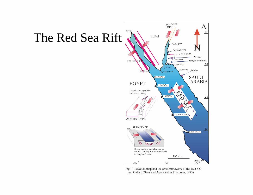
The Red Sea Rift
How the Red Sea Rift initiated?• Results of seismic and other geophysical
investigations suggest that strike-slip processes controlled the break-up of the Arabian plate from Africa and initiated the Red Sea Rift. Early oceanisation was facilitated by nucleation of pull apart basins and massive intrusives (Makris and Rihm, 1991).
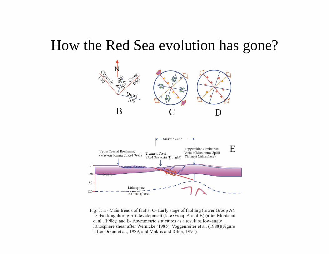
How the Red Sea evolution has gone?• The evolution of the Red Sea has gone through
different stages. It was a zone of structural weakness already during the Pan-African orogeny approximately 600 Ma. A major reactivation, however, that gradually led to the present-day configuration was initiated during the late Oligocene with intense magmatic activity and the development of a continental rift. Wrench faulting played a key role in the early evolution of the Red Sea, as it shaped most of its western flank as a sharp plate boundary and resulted in the generation and rapid oceanisation of linearly arranged pul1 apart basins.
How the Red Sea evolution has gone?• Spatial distribution of these basins reflects the
geometry of the strike-slip zone, which was controlled by pre-existing fault systems like the Najd Shear System, the Central African Fault Zone or the Onib-Hamisana and Baraka suture zones. Strike-slip motion along the latter zones of weakness influenced mainly the Egyptian and Sudanese coastal areas. Arabia was therefore separated from Africa by oceanisation in those regions, where pull apart basins developed. They were still connected in the in-between segments by stretched continental crust.
How the Red Sea evolution has gone?
• With Arabia as the ”moving” and Africa as the ”stable” plate the eastern Red Sea flank was formed by pure shear through stretching, thinning and diffuse extension. As a consequence, the eastern and western flanks of the Red Sea are asymmetrical (Makris and Rihm, 1991)(Fig. 1E). The acceleration of the movement of Arabia in early/middle Miocene could no longer be accommodated by the opening in the Gulf of Suez and consequently the Dead Sea strike-slip fault developed approximately 14 Ma ago.
How the Red Sea evolution has gone?
How the Red Sea evolution has gone?• Since plate motion was still oblique to the major
structural trends, the pull apart evolution on the western flank continued and the oceanisation was accentuated, while in the north the eastern flank developed en-echelon fractures of ”Aqaba-orientation”. Seafloor spreading commenced 5 Ma ago at parts of the central and southern Red Sea. This final stage is also responsible for the bathymetry with maximum depth values of 3000 m in the seafloor spread areas and a much shallower basin in the north. The metalliferous ”Red Sea deeps” are either associated with this infant mid-ocean ridge or with the en-echelon fractures in the north.
The outcropping sediments along the Red Sea coast
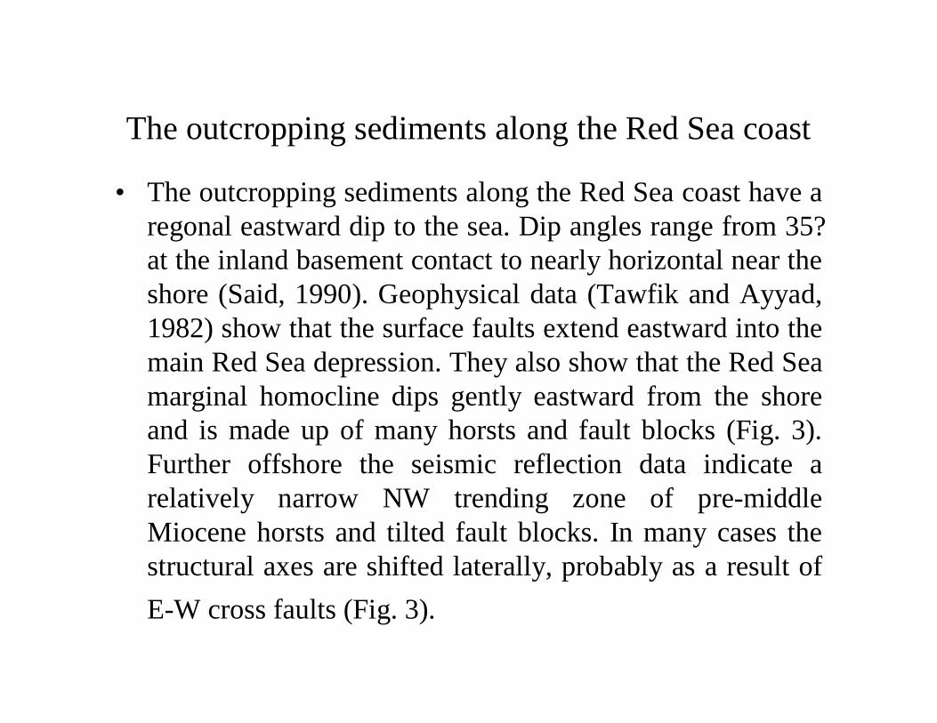
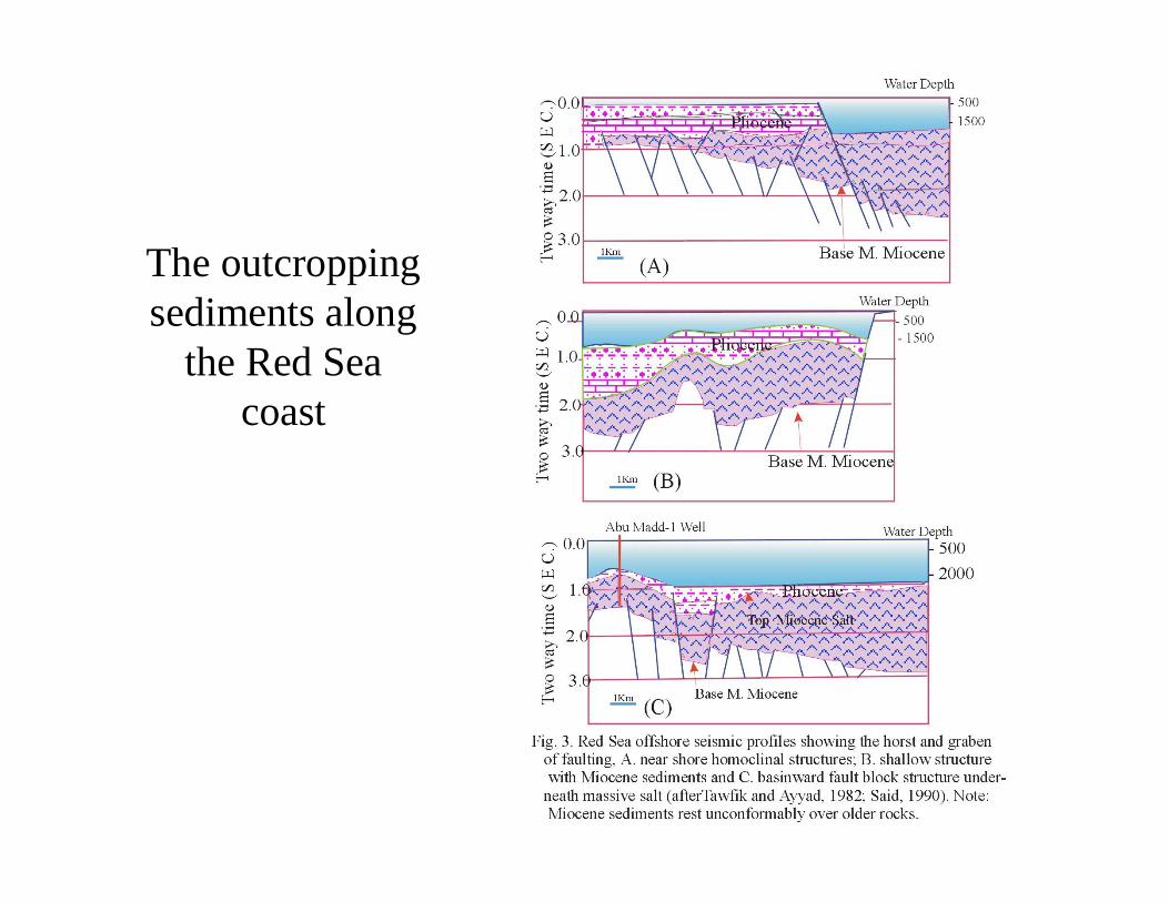
• The outcropping sediments along the Red Sea coast have a regonal eastward dip to the sea. Dip angles range from 35?at the inland basement contact to nearly horizontal near the shore (Said, 1990). Geophysical data (Tawfik and Ayyad, 1982) show that the surface faults extend eastward into the main Red Sea depression. They also show that the Red Sea marginal homocline dips gently eastward from the shore and is made up of many horsts and fault blocks (Fig. 3). Further offshore the seismic reflection data indicate a relatively narrow NW trending zone of pre-middle Miocene horsts and tilted fault blocks. In many cases the structural axes are shifted laterally, probably as a result of E-W cross faults (Fig. 3).
The outcropping sediments along
the Red Sea coast
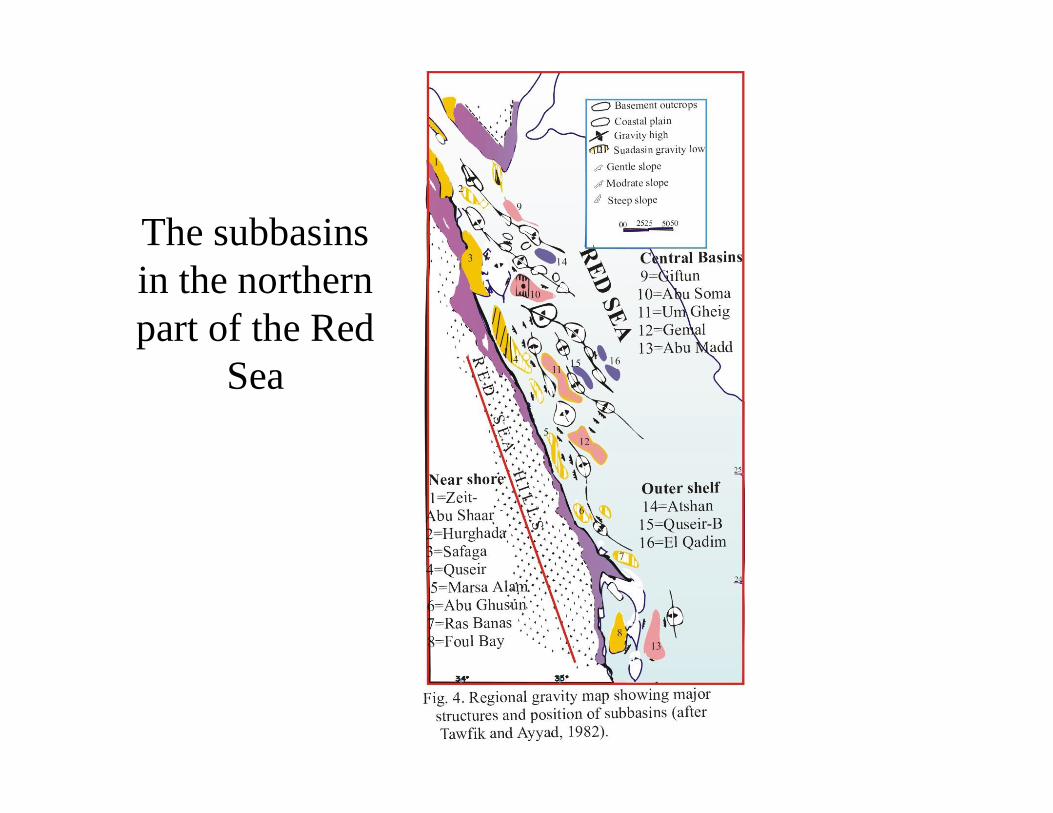
The subbasins in the northern part of the Red Sea• Three sets of NW trending negative gravity
anomalies are shown on the regional gravity map (Fig. 4), which are believed to represent subbasinswithin the Red Sea Basin (Tewfik and Ayyad, 1982). The subbasins trend is generally parallel to the coast line of the Red Sea shelf of Egypt and are separated by structural ridges. The subbasinsin the northern part of the Red Sea extend northward to the southern areas of the Gulf of Suez, which suggest having a similar stratigraphicsequence. The subbasins differ in size, age and stratigraphy, but all seem to have been formed during the development of the regional arching and subsequent collapse of the Red Sea.
The subbasinsin the northern part of the Red
Sea
Near-shore subbasins• This group of elongated north-west trending subbasins are
located adjacent to the Red Sea coastal plain (Fig. 4). Eight subbasins are delineated from north to south, namely: Zeit-Abu Shaar, Hurghada, Safaga, Quseir, Marsa-Alam, Abu Ghussun, Ras Benas and Foul Bay sub- basins.
• This group may have significant merits for hydrocarbon exploration. Sediments reaching 16000 feet in thickness, and including several thousands feet of Early Miocene shales and silts have been penetrated in the eastern flanks of Safaga and Quseir subbasins. However, seismic data suggest that some subbasins (ex. Foul Bay) contain a much thinner sedimentary section, generally of Miocene or younger age.
• Detrital sediments derived from the Red Sea hills are believed to have been accumulated in these subbasins, forming prospective oil reservoirs. Although the pre-rift stratigraphic sequence of Wadi Quseir has not been found, to date, in the offshore wells south of Hurghada, it is assumed that these rocks may be preserved in the near-shore subbasins.
Central subbasins• Central subbasins include the subbasins that are
located in the central shelf further east of the near-shore subbasins. From north to south, five north-west and west-northwest trending subbasins are delineated, as: Giftun, Abu Soma, Un Gheig, Gemal and Abu Madd subbasins.
• Little exploratory drilling has been done in these areas. However, aeromagnetic data suggest that over 18,000 feet of sediments are present in the Abu Madd subbasin. Hydrocarbon gases were encountered during the drilling of Union’s Abu Madd-1 well, indicating the presence of petroleum source rocks within this subbasin.
Outer shelf subbasins• Outer shelf subbasins include gravity lows
in deep water on the outer Red Sea shelf. These are the Atshan, Quseir-B and El Qadim subbasins. These features are relatively small and probably filled with Middle Miocene evaporites and younger continental sediments. This group seems to have the least exploration potential at present.
The Gulf of Suez and its importance as a
main hydrocarbon target
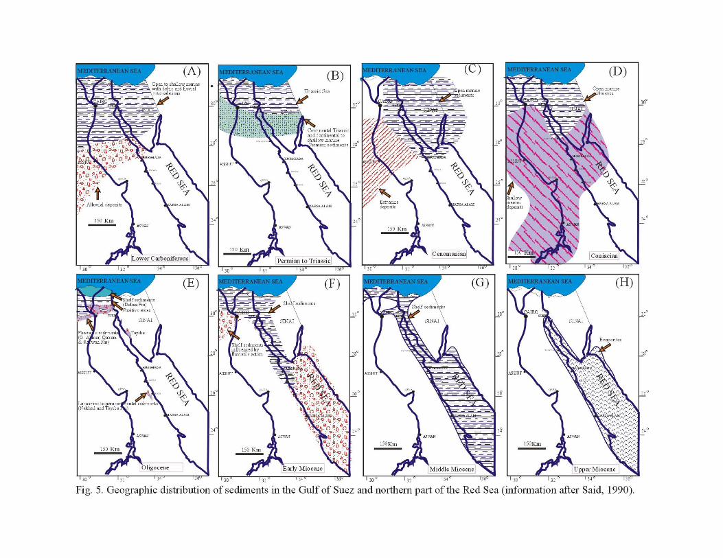
• The Gulf of Suez is considered the most important hydrocarbon province in Egypt, continuous development of exploration reflecting its importance as a main hydrocarbon target (E.G.P.C., 1986). Oil is present in and is produced from Basements, and sediments belonging to the Paleozoic, Mesozoic and Cenozoic (Fig. 5). The fields are mainly structural traps, though some are stratigraphic.

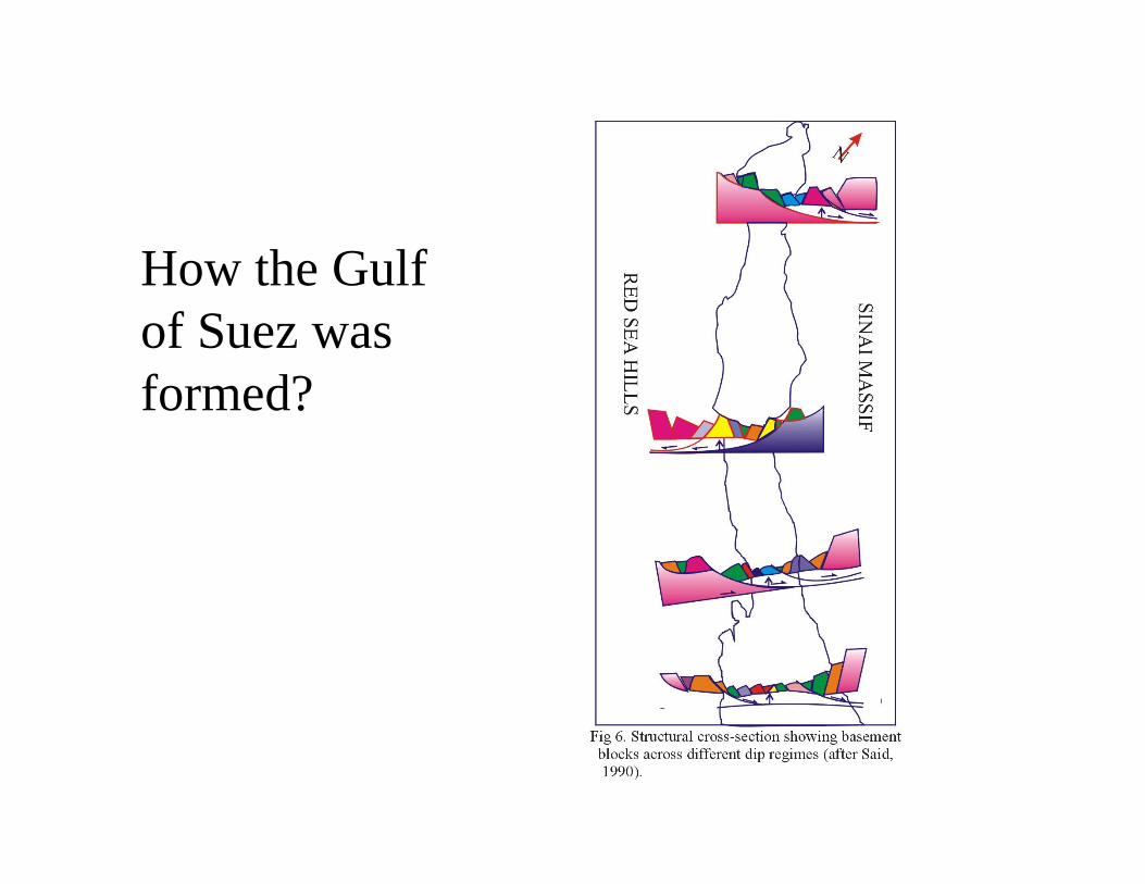
How the Gulf of Suez was formed?• The Gulf of Suez graben was formed as a result of
tectonic movements initiated in the Oligocene, which continued with intensity until post-Miocene times. Tensional faults of considerable displacements determine the configuration of the graben and its boundaries. Within the confines of these boundary faults the graben area is dissected into numerous pre-Miocene fault blocks of various sizes. The tilt of these blocks is predominently to the southwest in the northern and southern parts of the Gulf, and to the northeast in the central part (Fig. 6). The different blocks were subject to varying degrees of erosion.
How the Gulf of Suez was formed?
How the Gulf of Suez was formed?• The Miocene transgression covered an eroded and
topographically uneven surface of pre-Miocene rocks. Accordingly, Miocene sediments rest unconformably over rocks ranging in age from Precambrian to late Eocene (Fig. 3). The rugged topography of the pre-Miocene surface is evident from the presence of both shallow and deep-water marine environments side by side in the early stages of the Miocene transgression. These conditions were favorable for the development of reefs on the uplifted blocks and/or organic-rich clastics on the downthrown blocks.
• The movements continued during the Miocene and latter times, rejuvenating old lines and producing an environment where great lateral facies changes occured. These Miocene and younger events affected the oil habitat of the Gulf, the ’cooking’ conditions of source rockes, the oil migration process, and the type and size of the traps.
Gulf of Suez & The Hydrocarbon Production• According to Said (1962 and 1990) the stratigraphic
succession of the Gulf of Suez province is generally characterized by three main depositional phases, relative to the Miocene rifting events, as: pre-rift phase (Early Paleozoic to Eocene); Syn-rift phase (Early-Middle Miocene) and post-rift (Late Miocene and Pliocene). The first and second phases include important hydrocarbon source and reservoir rocks while the third depositional phase is important because of its evaporitic seal. These major sedimentary successions accumulated under different structural settings on the pre-Cambrian Basement Complex with distinct inter- and intraformationalunconformities and hiatuses of different magnitudes. It is worth mentioning that all type-sections of the formal stratigraphic rock units, except the Paleocene-Early Eocene sequences, occur at surface localities on both edges of the Suez rift.
Gulf of Suez & The Hydrocarbon Production• The oldest rock units are Araba and Naqus formations
of Cambro- Ordovician (?) age. These represent a regressive marine cycle, which terminated in the development of continental facies. The ArabaFormation (Hassan, 1967) is dominated by sandstones and mudstones of shallow marine facies capped by thick, massive, pebbly, cross-bedded sandstones of fluviatile regime (Naqus Formation). As the type-sections of both units are located at the southwest part of Gebel Qebliat it is proposed that they are grouped with the Qebliat Group. These siliciclastic units represent one of the main hydrocarbon reservoirs in July, Ramadan, Bakr, Sidki and October oil fields. They are equivalent to the informal ”Nubia D and C”respectively.
Gulf of Suez & The Hydrocarbon Production• The Qebliat Group is unconformably overlaid by
the Um Bogma Formation (Kostandi, 1959) with characteristic fossiliferous marly dolomite faciesof Early Carboniferous age. These carbonates are overlaid by the marine fossiliferous black shaleswith thin carbonate intercalations of the Abu Durba Formation of Late Carboniferous age (Kora, 1988).
• The second important siliciclastic sequences of alternating marine and continental suites are represented by the Rod El Hamal Formation of Late Carboniferous (?)/Permian age which form the upper unit of the Ataqa Group (Soliman and El Fetouh; 1970 and Darwish, 1992).
Gulf of Suez & The Hydrocarbon Production• The continental red beds of the Qiseib Formation of
Late Permian Triassic age and the overlying MalhaFormation (Abdallah et al., 1963 and Darwish, 1992) that belong to the Jurassic/Early Cretaceous age, represent El Tih Group of Barakat et al. (1986). These rock units include one of the main sandstone hydrocarbon reservoirs in the Ras Gharib, Bakr, ShoabAli, July, Budran and other oil fields.
• The Nezzazat Group of Steen and Helmy (1982) are the first marine upper Cretaceous sequences represented by clastic carbonate facies of fluctuating transgressive sea. It includes the Raha, Wata and Matulla formations of Cenomanian to Early Senonian age. Good reservoirs in the oil fields of Bakr, Ras Gharib, Amer, Kareem, July and Ramadan fields belong to Raha and Matullasandstones.
Gulf of Suez & The Hydrocarbon Production• The Late Senonian Late Eocene sequences are included under
the term El Egma Group (Darwish and El-Araby, 1993) which includes the maximum fIooding events during the Maastrichtian/Paleocene. These are represented by SudrFormation and Esna Shales which are overlain by the Eocene carbonate sequences. The latter are represented by two differentfacies types. The first is the Nile Valley facies which predominates in the southern half of the Gulf of Suez and is represented by the Thebes, Samalut and Mokattam formations. The second Eocene facies type is recorded in the northern half of the Suez Gulf and includes the Waseiyit, Rod El Awad, Thaland Tanka formations (Abu Khadrah et al., 1987 and Barakat et al., 1988). They comprise platform carbonate and reefal faciesreflecting gradual shallowing and pulsative deformational features due to syn-depositional tectonics. The main mature hydrocarbon source rocks are included in Campaniancarbonates, partly the Esna Shales and the Middle-Upper Eocene marls and limestones of Rod El Awad, Thal and Tankaformations.
Gulf of Suez & The Hydrocarbon Production• During the Late Eocene-Early Oligocene Tayiba red beds were
developed with variable thicknesses. They are truncated and capped partly by basaltic sheets and dykes of Oligocene age (about 27 m.a.; Said, 1990).
• The essential Miocene syn-rift marine sequences begin with coarse clastics (conglomerates and sandstones) of Nukhul Formation. These are followed by the open marine calcareous shales, limestones and sandstones, partly of turbiditic origin, of the RudeisFormation. Both units belong to the Lower Miocene GharandalGroup. The evaporite series with inter-evaporite shales and marls of lagoonal and intertidal domains are collectively known as RasMalaab Group. This series is differentiated into Kareem, Belayim, South Gharib and Zeit formations of Middle to Late Miocene age. Hydrocarbon production from these Miocene sequences is realized from most clastic and carbonate rocks of Nukhul, Rudeis, Kareem and upper member of Belayim formations in Rudeis, Bakr, Kareem, Yusr, Belayim, Morgan, Ghara, Ras Fanar, Zeit Bey, Sheab Gharib, Ras El Bahar, Warda and many other fields. The South Gharib and Zeit formations are considered as partially oil-bearing in Belayim and Warda oil fields.
Gulf of Suez & The Hydrocarbon Production
• These open marine syn-rift formations are correlated with their counterparts of coastal and marginal faciesof Abu Gerfan, Gharamul, Gemsa and Sarbut El-Gamal formations (Ghorab and Marzuk, 1967; Stratigraphic sub-Committee, 1974 and Darwish and El Azabi, 1993).
• The post-Miocene sequences are composed mainly of clastics, carbonates and evaporite intercalations, which conformably overlie the Late Miocene evaporites. These are considered to be of Pliocene/Recent age and collectively treated as El Tor Group (Webster and Ritson, 1982).
Gulf of Suez & The Hydrocarbon Production• Studies of the burial history and hydrocarbon source rock
maturation carried out by many workers have indicated a level of maturity sufficient to generate and expel oil and gas in most of the organic rich shales and limestones of Miocene and older sediments (Shaheen and Shehab, 1984; Schlumberger, 1984; Darwish and Hussein, 1991; Tewfik et al., 1992 and others). The level of maturity, accepted as the onset of oil generation, is around 3000m depth and the oil window of 40 to 180 TII is in the average between 3500 and 3800m depth. Oil generation began in Late Miocene to Early Pliocene time during the Late Miocene rift phase and migration began relatively later.
The Red Sea Rift• The Red Sea is the place with the earth’s
largest geologic features; the mid-ocean rift system strikes a continental platform, and splits it (Soliman et al., 1965 with references). Rifting has not been continuous, and pauses in the first half of the Tertiary saw important episodes of basaltic volcanic activity manifested by volcanic islands and other southern coastal reef foundations, and lava flows.
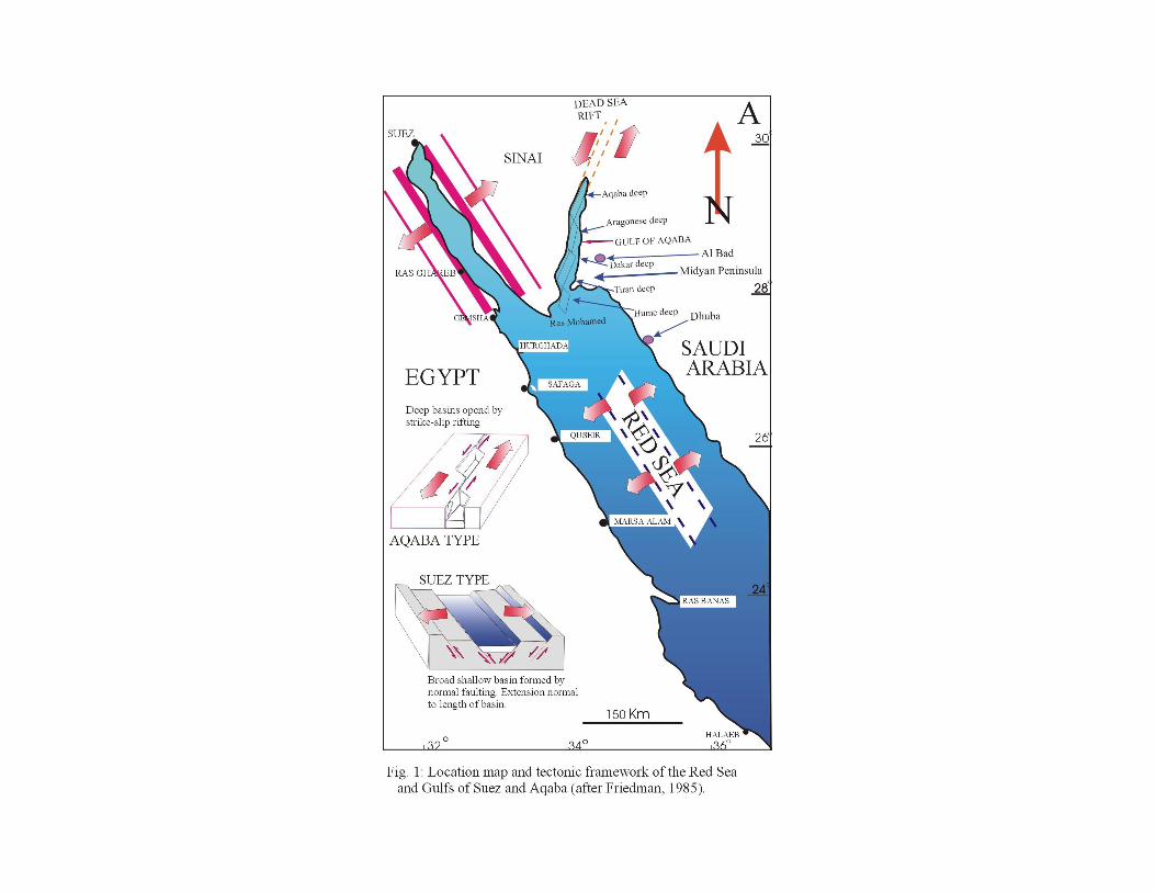
The difference between the Gulf of Suez and the Gulf of Aqaba
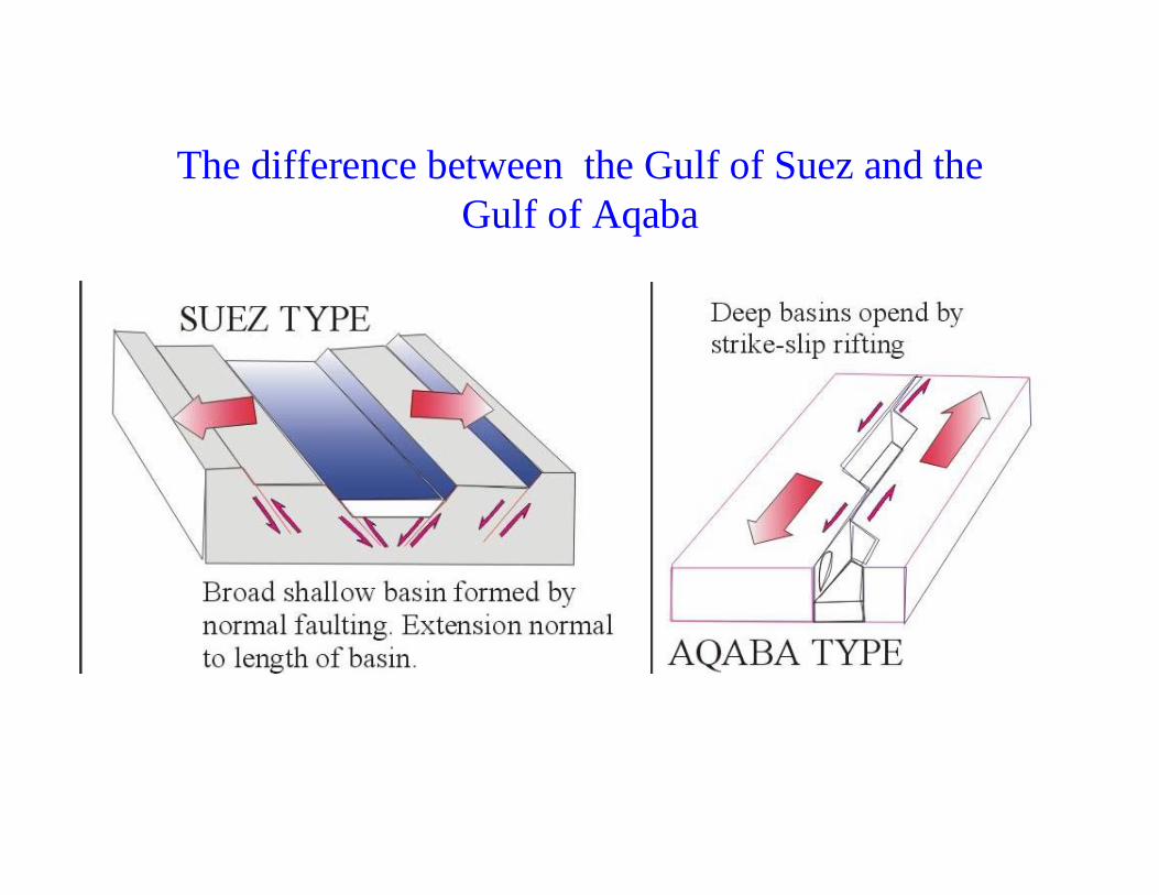
• The Gulf of Aqaba seems not to be a spreading center at present, but instead the Arabian side is sliding northwards relative to Sinai. This center is believed to change to strike-slip faulting in the southern third of the Gulf as the Arabian plate slides more in parallel with the Sinai (Friedman, 1985), and this has led to three deep basins in the Gulf of Aqaba (Fig. 1A). The Gulf with its deeper water, contains more than 2,000 to 3,000m of sediment infill, 5,000m of sediment infill in its northern and southern ends and somewhat less in the central area (Avraham, et al., 1979).
The difference between the Gulf of Suez and the Gulf of Aqaba
• The Gulf of Suez occupies a wide valley bordered by wide plains of low relief. It appears to be spreading and exhibits normal faulting. It has no sill at its connection with the Red Sea.
The difference between the Gulf of Suez and the Gulf of Aqaba
The difference between the Gulf of Suez and the Gulf of Aqaba
• It has been thought that the Gulf of Suez was developed in Miocene (see Soliman et al., 1965, with previous references) with the first stage of formation of the Red Sea, and that only the Gulf of Aqaba marginal faults were formed at that time. The faults that actually bound the modern Gulf and that lie inside the marginal faults (separated from them by the marginal blocks) are considered to have been developed with the second stage of tectonism only 4 to 5 million years ago. The depth of sediment infill of the Gulf of Suez has been known to reach 5000m and most likely to include Miocene-age sediments (Said, 1990).