Embed Size (px)
Citation preview
Social Safeguard Monitoring Report June – December 2014
SRI: National Highway Sector Project – Additional
Financing
Prepared by the Road Development Authority, Ministry of Highways and Investment Promotion for the Asian Development Bank.
This social safeguard monitoring report is a document of the borrower. The views expressed herein do not necessarily represent those of ADB's Board of Directors, Management, or staff, and may be preliminary in nature. Your attention is directed to the “terms of use” section on ADB’s website.' Thank you. In preparing any country program or strategy, financing any project, or by making any designation of or reference to a particular territory or geographic area in this document, the Asian Development Bank does not intend to make any judgments as to the legal or other status of any territory or area
MMIINNIISSTTRRYY OOFF PPOORRTTSS && HHIIGGHHWWAAYYSS DDEEVVEELLOOPPMMEENNTT
RROOAADD DDEEVVEELLOOPPMMEENNTT AAUUTTHHOORRIITTYY
AADDBB LLOOAANN 22776677 -- SSRRII
PROGRESS REPORT OONN
SSOOCCIIAALL SSAAFFEEGGUUAARRDD MMOONNIITTOORRIINNGG
NNAATTIIOONNAALL HHIIGGHHWWAAYYSS SSEECCTTOORR PPRROOJJEECCTT -- AADDDDIITTIIOONNAALL FFIINNAANNCCIINNGG
JJuunnee--DDeecceemmbbeerr 22001144
ii
TTaabbllee ooff CCoonntteennttss
11.. PPrroojjeecctt DDeessccrriippttiioonn ......................................................................................................................... 1
II.. IInnttrroodduuccttiioonn ............................................................................................................. 1
IIII.. IImmppaacctt aanndd OOuuttccoommee .............................................................................................. 2
IIIIII.. OOuuttppuuttss ................................................................................................................... 2
IIVV.. PPrroojjeecctt BBeenneeffiittss aanndd BBeenneeffiicciiaarriieess .......................................................................... 3
VV.. RRiisskkss aanndd AAssssuummppttiioonnss .......................................................................................... 3
VVII.. SSccooppee ooff SSoocciiaall SSaaffeegguuaarrddss.................................................................................... 4
VVIIII.. PPuurrppoossee ooff SSeemmii AAnnnnuuaall MMoonniittoorriinngg RReeppoorrtt ............................................................ 4
VVIIIIII.. MMeetthhooddoollooggyy ........................................................................................................... 4
IIXX.. PPrreeppaarraattiioonn ooff RReesseettttlleemmeenntt PPllaannss ............................................................ 5
XX.. MMeeaassuurreess ttaakkeenn ttoo mmiinniimmiizzee aanndd mmiittiiggaattee iimmppaaccttss .................................... 5
XXII.. EEssttaabblliisshhmmeenntt ooff FFiieelldd OOffffiicceess ................................................................... 5
22.. SSttaattuuss ooff RREESSEETTTTLLMMEENNTT PPLLAANN IImmpplleemmeennttaattiioonn ......................................................................... 6
22..11 IInnssttiittuuttiioonnaall AArrrraannggeemmeenntt aanndd CCaappaacciittyy .................................................................. 6
3. Scope of Impacts ......................................................................................................................... 10
33..22 CCpp--0022 HHiikkkkaadduuwwaa ((00++000000)) -- BBaaddddeeggaammaa -- NNiillhheennaa ((1144++334400)) RRooaadd ...................... 12
3.3. Cp-03 Aluthgama (53+480) - Southern Expressway (42+640) Road .................... 17
3.4. Cp-04 Katukurunda (0+000) - Nagoda (2+720) Road ......................................... 21
33..55 CCpp--0055 KKiirruullaappaannee ((00++000000)) -- HHoommaaggaammaa ((1155++550000)) RRooaadd ...................................... 23
33..66 CCpp--0077 PPaammaannkkaaddaa ((00++552200)) -- KKeessbbeewwaa ((1133++440000)) RRooaadd ........................................ 24
4 INCOME RESTORATION PROGRAMS (IRP) ................................................................................ 29
01. Ariyawithi Aluthge-Katuwawala, Piliyandala. ............................................. 31
55.. CCoommpplliiaannccee ssttaattuuss ....................................................................................................................... 33
1
11.. PPRROOJJEECCTT DDEESSCCRRIIPPTTIIOONN
II.. IINNTTRROODDUUCCTTIIOONN
Road density in Sri Lanka is higher than that in many developing countries. However, road
network standards and conditions are inadequate to meet the rapidly growing freight and
passenger traffic. This situation limits the contribution of roads to national development, economic growth, and poverty reduction. To ensure sustainable and regionally balanced
economic growth within the country, the existing road infrastructure must be improved and
upgraded.
The Asian Development Bank (ADB) has supported the reform program and finances the
improvements & upgrading of national highways (NHs). On 15 December 2005, ADB Board
of Directors approved a loan of $150 million from its ordinary capital resources to help
finance the National Highways Sector Project. The Project is the first sector loan in Sri Lanka. The Loan was signed in Colombo on 14 December 2006 and became effective on 20
February 2007.
A major change of project scope was approved on 9 November 2010 to meet the highway-
upgrading cost increase and included (i) cancelling the component to finance land
acquisition and resettlement along Colombo links and (ii) reducing the pilot performance-
based maintenance component to 300 km from the 1,500 km originally envisaged.
With a minor scope change in February 2011, the road improvement component under the
original loan consists of a total of 238 km national highway sections as shown in table below,
and performance-based maintenance support for 108 km of national highway, which component was completed by the end of December 2012.
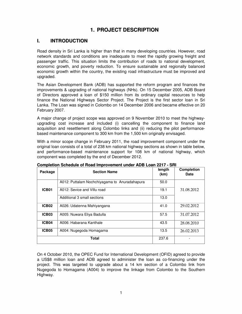
CCoommpplleettiioonn SScchheedduullee ooff RRooaadd IImmpprroovveemmeenntt uunnddeerr AADDBB LLooaann 22221177 -- SSRRII
Package Section Name length
(km)
Completion
Date
ICB01
A012: Puttalam Nochchiyagama to Anuradahapura 50.0
31.08.2012 A012: Sevice and Villu road 19.1
Additional 3 small sections 13.0
ICB02 A026: Udatenna Mahiyangana 41.0 29.02.2012
ICB03 A005: Nuwara Eliya Badulla 57.5 31.07.2012
ICB04 A006: Habarana Kanthale 43.5 28.08.2010
ICB05 A004: Nugegoda Homagama 13.5 26.02.2013
Total 237.6 -
On 4 October 2010, the OPEC Fund for International Development (OFID) agreed to provide
a US$8 million loan and ADB agreed to administer the loan as co-financing under the
project. This was targeted to upgrade about a 14 km section of a Colombo link from
Nugegoda to Homagama (A004) to improve the linkage from Colombo to the Southern
Highway.
2
TThhee FFiirrsstt AAddddiittiioonnaall FFiinnaanncciinngg PPrroojjeecctt -- of US$85 million from ADB’s ordinary capital
resources for the NHSP’s original loan was approved on 5 August 2011, signed on 14
December 2011, and became effective on 23 February 2012. The first additional financing includes rehabilitating and upgrading an additional 62 km of national highways.
IIII.. IIMMPPAACCTT AANNDD OOUUTTCCOOMMEE
The main impact of the additional financing loan is sustainable and regionally balanced
economic growth contributing to reduction of poverty. The outcome is improved accessibility
and connecting through an upgraded and maintained national highway that lowers transport
cost and travel time.
The project will contribute significantly to the urban/semi-urban/rural communities who have been suffering from unbearable traffic congestion created by bad and narrow condition of
roads with lack of road behavioral pattern and accident prone traffic environment. The six
road roads have been made a links with southern expressway and the main cities in western
and southern provinces.
The interviews revealed that men and women like poor employees in beneficiary area could
reach their work place early after the proposed road development. They will have more time
to engage with extra earnings or spend time with family members. Inhabitants are certainly ready to increase their mobility. In this context, improved road will contribute and motivate
these people to convert their impoverished houses in to semi-permanent or permanent
conditions; pit latrines to sanitary toilets; access to safe drinking water sources and
electricity. The cost of land will be increased rapidly with the development, and resulting economic surplus through high cost of land will be invested in economic ventures generating
accelerated economic growth.
It is anticipated to achieve 10% increase of traffic volume, 25% reduction in travel time, 15%
reduction in maintenance cost per Km, reduction of staff per Km and 15% reduction in
vehicle operating cost. Other than that, the project will contribute to increase the usage of
southern expressway and it may effect to development of the tourism.
IIIIII.. OOUUTTPPUUTTSS
The National Highways Sector Project(NHSP) first additional financing has been improved
about 49.4 kilometers of National highways comprising 31.60 km in the Western Province and 17.80 km in Southern Province. The benefit of the road development project is gone to
western and southern provinces.
The main output of the project is rehabilitation and upgrading of six road section and these
selected roads about 49.4 Km is shown in table of selected road sections of first additional
financing of NHSP.
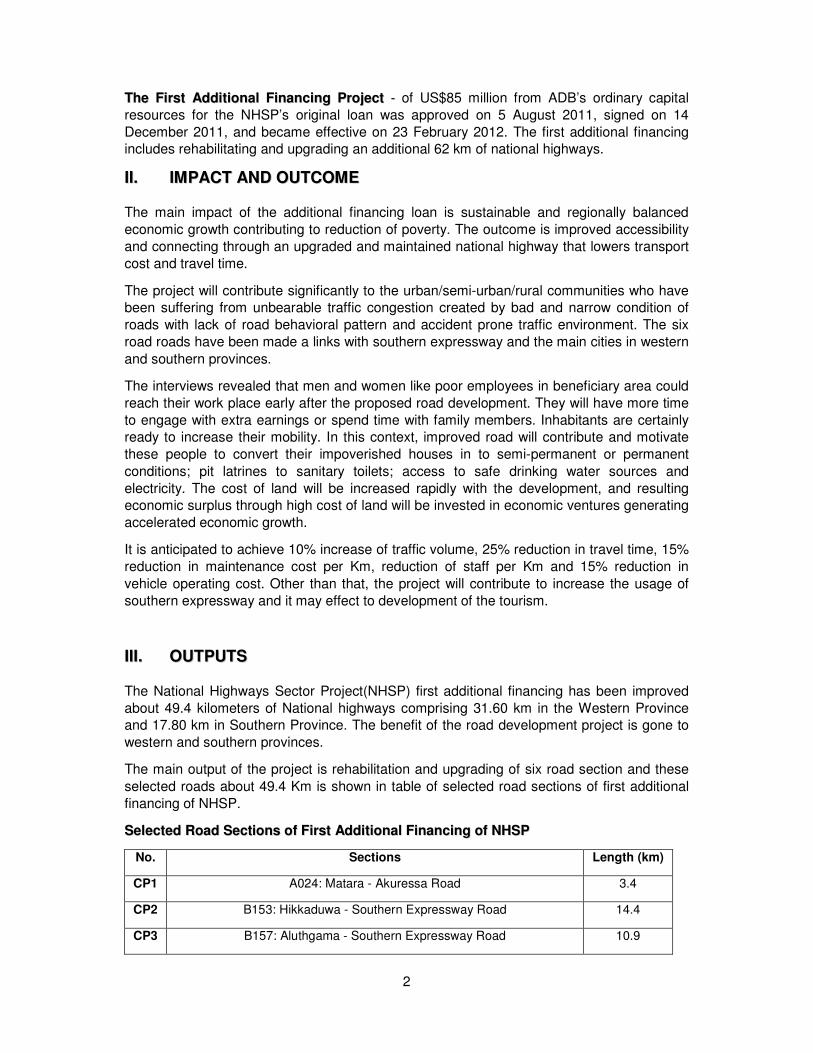
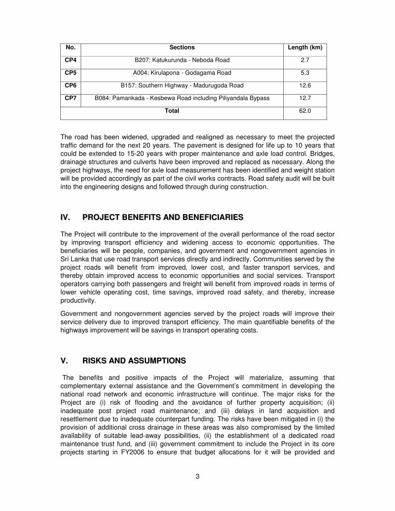
SSeelleecctteedd RRooaadd SSeeccttiioonnss ooff FFiirrsstt AAddddiittiioonnaall FFiinnaanncciinngg ooff NNHHSSPP
No. Sections Length (km)
CP1 A024: Matara - Akuressa Road 3.4
CP2 B153: Hikkaduwa - Southern Expressway Road 14.4
CP3 B157: Aluthgama - Southern Expressway Road 10.9
3
No. Sections Length (km)
CP4 B207: Katukurunda - Neboda Road 2.7
CP5 A004: Kirulapona - Godagama Road 5.3
CP6 B157: Southern Highway - Madurugoda Road 12.6
CP7 B084: Pamankada - Kesbewa Road including Piliyandala Bypass 12.7
Total 62.0
The road has been widened, upgraded and realigned as necessary to meet the projected
traffic demand for the next 20 years. The pavement is designed for life up to 10 years that
could be extended to 15-20 years with proper maintenance and axle load control. Bridges,
drainage structures and culverts have been improved and replaced as necessary. Along the
project highways, the need for axle load measurement has been identified and weight station
will be provided accordingly as part of the civil works contracts. Road safety audit will be built
into the engineering designs and followed through during construction.
IIVV.. PPRROOJJEECCTT BBEENNEEFFIITTSS AANNDD BBEENNEEFFIICCIIAARRIIEESS
The Project will contribute to the improvement of the overall performance of the road sector by improving transport efficiency and widening access to economic opportunities. The
beneficiaries will be people, companies, and government and nongovernment agencies in
Sri Lanka that use road transport services directly and indirectly. Communities served by the
project roads will benefit from improved, lower cost, and faster transport services, and thereby obtain improved access to economic opportunities and social services. Transport
operators carrying both passengers and freight will benefit from improved roads in terms of
lower vehicle operating cost, time savings, improved road safety, and thereby, increase
productivity.
Government and nongovernment agencies served by the project roads will improve their
service delivery due to improved transport efficiency. The main quantifiable benefits of the
highways improvement will be savings in transport operating costs.
VV.. RRIISSKKSS AANNDD AASSSSUUMMPPTTIIOONNSS
The benefits and positive impacts of the Project will materialize, assuming that complementary external assistance and the Government’s commitment in developing the
national road network and economic infrastructure will continue. The major risks for the
Project are (i) risk of flooding and the avoidance of further property acquisition; (ii)
inadequate post project road maintenance; and (iii) delays in land acquisition and resettlement due to inadequate counterpart funding. The risks have been mitigated in (i) the
provision of additional cross drainage in these areas was also compromised by the limited
availability of suitable lead-away possibilities, (ii) the establishment of a dedicated road
maintenance trust fund, and (iii) government commitment to include the Project in its core projects starting in FY2006 to ensure that budget allocations for it will be provided and
4
sustained. The Project will also finance land acquisition and resettlement expenditures of the
Colombo links.
VVII.. SSCCOOPPEE OOFF SSOOCCIIAALL SSAAFFEEGGUUAARRDDSS
The six sub projects have been classified as category A with respect to the Safeguard Policy
Statement, 2009. There are six separate resettlement plans have been prepared for all the sub projects to mitigate and address the resettlement impacts of sub projects and associated
losses. The resettlement plans have been prepared based on the Government’s Land
Acquisition Act (LAA) of 1950, ADB’s Safeguard Policy Statement (2009) and National
Involuntary Resettlement Policy (NIRP) 2001.
The Economic and social assessment found no indigenous people residing in the project
influence area or affected by the project. Most project communities are Singhalese, the rest
being majority Muslim or Tamil. The project will support the equal treatment of all groups,
particularly when land acquisition is required for road widening.
Men and women engaged in construction during subproject implementation will be paid equally for equal work, which will be monitored by construction supervision consultants.
Although the proposed additional financing will not directly empower women, it will provide
opportunities to ensure benefits to women through improved public transport services and
better access to education, health care, markets, etc.
The project has been introduced Grievance Redress Mechanism (GRM) associated with
ADB’s safeguard policy. The GRM is support genuine claimants to resolve their problems
through mutual understanding and consensus reaching process with relevant parties.
VVIIII.. PPUURRPPOOSSEE OOFF SSEEMMII AANNNNUUAALL MMOONNIITTOORRIINNGG RREEPPOORRTT
The monitoring process of the social safeguards compliance of the project is entrusted to Project Management Unit and Environmental & Social Management Unit of RDA. This semi
Annual report is prepared by Project Management Unit to present the situation of social
safeguard of the project and the monitoring results to ADB.
VVIIIIII.. MMEETTHHOODDOOLLOOGGYY
Conduct of Socio-Economic Surveys and Preparation of Resettlement Plans for the A024,
B153, B157, B207, B084 and A004 Highways under ADB Loan 2767-SRI. Socio economic
surveys were conducted for the above highways to ascertain the degree of socio-economic impact on the affected population as a result of acquisition of properties for the improvement
and widening of the relevant highways
Methodology Adopted
Two sets of questionnaires were used to gather information
Land Acquisition (Census)Questionnaire
Socio Economic Questionnaire
5
While total affected population was subjected to the land acquisition survey, a sample of
20% was surveyed to collect information on social issues.
During the land acquisition surveys the data was collected on all assets to be lost including
plants and trees. Socio economic survey was conducted to gather information on house hold
income and expenditure patterns, health status, indebted nests, communication networks, community participation, health parameters, gender issues and migration patterns.
Two local universities were hired to conduct the surveys assisted by the Resettlement
Assistants and supervised by the Resettlement Consultant attached to the project. Data was analyzed electronically by the two universities and the Environmental and Social Division of
the RDA, and required information for the preparation of resettlement plans were generated.
IIXX.. PPRREEPPAARRAATTIIOONN OOFF RREESSEETTTTLLEEMMEENNTT PPLLAANNSS
Resettlement plans were prepared and updated by the Resettlement Consultant hired by the
PMU and Resettlement Experts hired by the PMU, with some inputs at the later stage from External Consultants employed by the ADB which have been already dealt by the
consultants hired by the PMU. The resettlement plans were reviewed by the ESD before
they were submitted to ADB for approval.
XX.. MMEEAASSUURREESS TTAAKKEENN TTOO MMIINNIIMMIIZZEE AANNDD MMIITTIIGGAATTEE IIMMPPAACCTTSS
In keeping with the national policy of minimizing impact on the affected and the social
safeguard policies of the ADB where it categorically states that where possible acquisition should be avoided, action was taken by the PMU to revise the design of the highways
without compromising the utility value of the highways to realize the intended purposes for
which the project had been conceived. The strategies adopted were to reduce the platform
width of the highways where buildings are located in order to avoid demolition of parts of buildings .and in certain instances to avoid buildings completely by adjusting the center lines
towards the land owned by state organizations. The final land surveys are at the completion
stage to accommodate the subsequent changes made to the design. This measure has
resulted in the number of affected coming down drastically.
XXII.. EESSTTAABBLLIISSHHMMEENNTT OOFF FFIIEELLDD OOFFFFIICCEESS
In order to ensure easy access to the affected on services and information field offices had
been established in each of the roads manned by resettlement staff they will interact with the
affected and maintain a continuous dialogue with them.
6
22.. SSTTAATTUUSS OOFF RREESSEETTTTLLMMEENNTT PPLLAANN IIMMPPLLEEMMEENNTTAATTIIOONN
22..11 IINNSSTTIITTUUTTIIOONNAALL AARRRRAANNGGEEMMEENNTT AANNDD CCAAPPAACCIITTYY
Road Development Authority being the execution agency for road development has
administrative responsibility for implementation of the project under general supervision of
the Ministry of Ports and Highways (MoPH). MoPH has established Project Management
Units (PMU) for execution of special projects due to their importance, priority, magnitude of investment and external collaboration etc. PMUs have to accomplish a time-bound
programme through a planned set of interventions agreed upon by concerned authorities.
PMUs work under the general supervision of RDA, but have direct linkages and access to
MoPH to expedite their work. Thus, PMU is the focal institution responsible for RP’s implementation at operational level. PMUs have been strengthened with certain degree of
financial autonomy and administrative flexibility subject to the guidance and supervision
of the Ministry of Ports and Highways and directives of the General Treasury.
Opening of a new road or improving and widening existing roads involve
accomplishments of several legal and social requirements in addition to their construction
related work. In this regard, several agencies have direct involvements with these activities
and early identification of them has several advantages for project implementation. Following are the key state agencies that will have direct involvement with resettlement interventions;
• Ministry of Ports and Highways
• Ministry of Land and Land Development
• Divisional Secretary and his staff including Grama Niladaris
• Survey Department
• Valuation Department
• Government Printer
• Central Environmental Authority
• Urban Councils
• Ceylon Electricity Board
• Water Supply and Drainage Board
• Sri Lanka Telecom Ltd.
Contractors and consultants employed by the PMU, Community Based Organizations of DPs, NGOs and other civic organizations also play a significant role in the implementation
process of the road project.
i. Project Management Unit
The Project Management Unit is headed by Project Director, whose staff consisted of
engineers, technical officers, consultants, land acquisition & resettlement staff and the
administrative staff.
ii. PMU performs following major activities;
Conduct awareness meetings with stake holders to disseminate information in respect of the
project and make continuous efforts to update information with necessary feedback and
support two-way communication regarding information collection and dissemination
• Distribute informative bulletins to ensure transparency
• Conduct Land Acquisition and Resettlement (LARS) and Social and Economic (SES)
surveys to collect necessary data for resettlement planning
7
• Coordinate and assist the land acquisition process with the DS, Survey and Valuation
departments and other relevant government agencies and DPs
• Prepare Resettlement Plans and implement them with the aim of restoring/improving the
lives of the Displaced Persons at least to the pre project level.
• Support execution of reasonable compensation package to realize the objectives of the
NIRP.
• Assist/ and coordinate with relevant agencies to restore/improve the income of the DPs
• Coordinate with the community based organizations to assist the DPs in resettlement
activities.
• Identify resettlement sites in consultation with the DPs and host communities when
necessary
• Assist DPs on resettlement in new sites selected jointly
• Expedite the payment of compensation by assisting the DS and the DPs
• Coordinate/monitor the activities of GRCs.
• Assist vulnerable; including women and poor.
• Monitor the resettlement plan with identifiable indicators.
• Develop a plan to address gender concerns.
• Implement the construction programme through contractors and supervision consultants.
• Monitor the construction programme.
• Prepare/submit required periodic reports to the relevant state agencies and ADB.
• Ensure flow of funds to maintain a healthy cash flow
• Maintain MIS for the project with networking to MoPH and RDA
iii. ESD & Land Division
ESD & Land Division are the focal divisions of RDA for safeguard compliances. ESD assists
PMU in conducting the Land Acquisition and Resettlement and Social and Economic
surveys including training of survey enumerators and data analysts. Reviewing of RPs is a
major function of ESD before they are submitted to the external authorities, including ADB.
ADB has assisted to establish and improve ESD with its technical assistance support in
2006/2007.
iv. Divisional Secretariat
Divisional Secretary is responsible for civil administration of the division and hence land
acquisition comes under his/her purview within the division. He/ She have coordinating
responsibilities of all development work, in addition to planning and implementation of its own development projects/ programmes in the division. DS is empowered with statutory
provisions to acquire land and vest them with the agencies that required land under LAA.
Similarly, before commencement of construction, RDA has to wait till DS vest land in RDA
after going through LAA process. Although, formally all land acquisition work has to be done
by the DS office, now for acceleration of the process, PMU assists DS for various activities
of the acquisition, including arranging meetings with DPs and other stakeholders, preparation of paper work and gazette announcements for DS signature, and distribution of
DS office notices to public. DSs are happy with this arrangement as it helps him to overcome
DS office resource constraints with regard to land acquisition.
v. Field Office of the PMU
A field office will be established to facilitate the land acquisition and resettlement inclusive of
income restoration activity. This office will be located within the project area. A Resettlement Assistant will be stationed at this office with supportive staff to attend to the problems of DPs
and take necessary actions to solve them under the guidance of Project Director/ NHSP. It
8
will help DPs to have better solutions by way of coordinating DPs and relevant authorities
that are functioning in the areas where DPs need attention. Especially, this field office will be
an attractive resource center for DPs who need income restoration support. It will be equipped with information required for various types of livelihood development
opportunities and post product situations, including marketing. This office will help DPs to
identify feasible income generating ventures and implement them successfully with the
support of PMU.
vi. Disclosure and Public Consultation
Twelve public meetings were conducted among the primary stake holders to disseminate
information in respect of the above projects in addition to 28 meetings conducted with the
affected people of other 07 projects which are implementing under the National Highways
Sector Project Additional Finance to engage in a continuous dialogue with the affected and
interested people. The continuous telephone message which we receive daily from the
public on the status of the roads where land acquisition has been temporarily suspended is
an indication of the impact of consultations meetings PMU had with them. Sinhala version of
the entitlement matrix and the information flyer in both Tamil and Sinhala languages were distributed among the affected people.
In addition that, the consultation has been continuing in different stages of the land
acquisition process. The land acquisition process has different gazette notification like Section 02, Section 38(a) and Section 7. Those gazette notification has been distributed
among the displaced persons. Moreover, the Resettlement Assistants are appointed by the
project to each and every sub project. Those officers always work with displaced persons to
solve their problems and assisted to DP’s livelihood restoration.
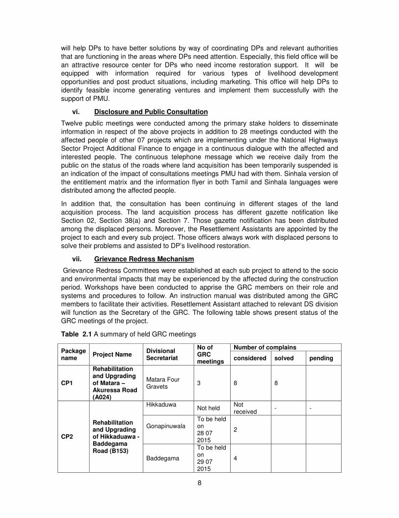
vii. Grievance Redress Mechanism
Grievance Redress Committees were established at each sub project to attend to the socio
and environmental impacts that may be experienced by the affected during the construction
period. Workshops have been conducted to apprise the GRC members on their role and
systems and procedures to follow. An instruction manual was distributed among the GRC members to facilitate their activities. Resettlement Assistant attached to relevant DS division
will function as the Secretary of the GRC. The following table shows present status of the
GRC meetings of the project.
Table 2.1 A summary of held GRC meetings
Package name
Project Name Divisional Secretariat
No of GRC meetings
Number of complains
considered solved pending
CP1
Rehabilitation and Upgrading of Matara – Akuressa Road (A024)
Matara Four Gravets
3 8 8
CP2
Rehabilitation and Upgrading of Hikkaduawa - Baddegama Road (B153)
Hikkaduwa
Not held Not received
- -
Gonapinuwala
To be held on 28 07 2015
2
Baddegama
To be held on 29 07 2015
4
9
CP3
Rehabilitation and Upgrading of Lewwanduwa – Aluthgama Road (B157)
Mathugama
2 2 2
Beruwala 3 60 54 6
CP4
Rehabilitation and Upgrading of Nagoda – Katukurunda Road (B207)
Kaluthara 2 11 11 -
CP7
Rehabilitation and Upgrading of Pamankada - Kesbewa Road (A084)
Thibirigasyaya Construction work not started yet Dehiwala Not received
Kesbewa 2 20 20
10
3. SCOPE OF IMPACTS
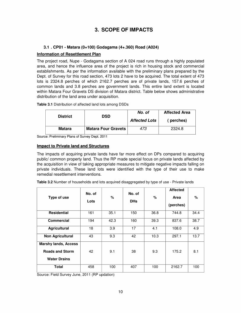
3.1 . CP01 - Matara (0+100) Godagama (4+.360) Road (A024)
Information of Resettlement Plan
The project road, Nupe - Godagama section of A 024 road runs through a highly populated
area, and hence the influence area of the project is rich in housing stock and commercial
establishments. As per the information available with the preliminary plans prepared by the Dept. of Survey for this road section, 473 lots 2 have to be acquired. The total extent of 473
lots is 2324.8 perches of which 2162.7 perches are of private lands, 157.6 perches of
common lands and 3.8 perches are government lands. This entire land extent is located
within Matara Four Gravets DS division of Matara district. Table below shows administrative distribution of the land area under acquisition.
Table 3.1 Distribution of affected land lots among DSDs
District DSD No. of
Affected Lots
Affected Area
( perches)
Matara Matara Four Gravets 473 2324.8
SSoouurrccee:: PPrreelliimmiinnaarryy PPllaannss ooff SSuurrvveeyy DDeepptt.. 22001111
IImmppaacctt ttoo PPrriivvaattee llaanndd aanndd SSttrruuccttuurreess
The impacts of acquiring private lands have far more effect on DPs compared to acquiring
public/ common property land. Thus the RP made special focus on private lands affected by the acquisition in view of taking appropriate measures to mitigate negative impacts falling on
private individuals. These land lots were identified with the type of their use to make
remedial resettlement interventions.
Table 3.2 Number of households and lots acquired disaggregated by type of use - Private lands
Type of use No. of
Lots %
No. of
DHs %
Affected
Area
(perches)
%
Residential 161 35.1 150 36.8 744.8 34.4
Commercial 194 42.3 160 39.3 837.6 38.7
Agricultural 18 3.9 17 4.1 108.0 4.9
Non Agricultural 43 9.3 42 10.3 297.1 13.7
Marshy lands, Access
Roads and Storm
Water Drains
42 9.1 38 9.3 175.2 8.1
Total 458 100 407 100 2162.7 100
Source: Field Survey June, 2011 (RP updation)
11
A great majority of land lots to be acquired are commercial and residential properties
amounting to 77 percent of the land lots under private ownership. These lots represent 73
per cent of the area in extent earmarked for acquisition from private individuals. The resettlement implication with these land lots are that their values are high and mostly owned
by economically and socially better off group of people whose expectations and aspirations
are also high with increased demand for restoration of their lives. The land use for
agricultural purpose accounts for 3.9 per cent of the lots required to be acquired with 4.9 per cent area representation, accounting for 108 perches. This shows relative insignificance of
agricultural land use in the area along the road side, and the predominance land use in
commercial and residential activities. Similarly, land use for non-agriculture purposes looks
meager in the project area showing only 9.3 per cent of land lots for the said purpose. The non-agriculture lot covers an area without a house or any other structure, but may have trees
or bare land portions without generating any income.
Table.3.3 Summary of Land Acquisition/Resettlement Impacts
Impact Extent
Affected Unit No of DHs
Permanent loss of private Residential/Commercial land
10% or less of land affected 93.9
Perch
63
11-50% of land affected 602.3 94
50% -100%of land affected 721.5 116
100% of land affected 164.7 39
Permanent loss of Agricultural/Non Agricultural land
10% or less of land affected 42.0
Perch
33
11-50% of land affected 82.9 16
50% -100%of land affected 174.6 27
100% of land affected 105.6 9
Loss of Structures
Shops 118
No of
Structures
96
Houses 95 90
Shop Houses 38 38
Other secondary structures
(Parapet walls, toilets, wells,
huts…etc.)
243 158
Relocation
Shops 26 No of 23
Houses 8 Structures
8
Shop Houses 8 8
12
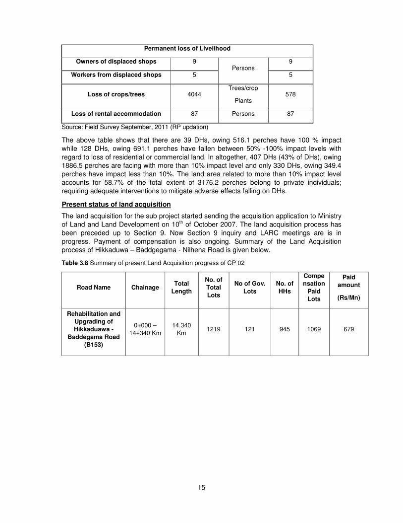
Permanent loss of Livelihood
Owners of displaced shops 34 Persons
34
Workers from displaced shops 27 27
Loss of crops/trees 737 Trees/crop
Plants 102
Loss of rental accommodation 42 Persons 42
SSoouurrccee:: FFiieelldd SSuurrvveeyy JJuunnee,, 22001111 ((RRPP uuppddaattiioonn))
The above table shows that there are 39 DHs, owing 164.7 perches have 100 % impact while 116 DHs, owing 721.5 perches have more than 50% impact with regard to loss of
residential or commercial land. In altogether, 249 DHs, owing 1488.5 perches are facing with
more than 10% impact level and only 63 DHs, owing 93.9 perches have impact less than
10%. The land area related to more than 10% impact level accounts for 69% of the total extent of private land acquired for the project; requiring adequate interventions to mitigate
adverse effects falling on DHs.
Present Status of Land Acquisition
This project road existing with the highly commercialized and densely populated residential
areas close to the Matara town, which is the highest populated township of the Matara
District of the Southern Province The land acquisition for the sub project started sending the acquisition application to Ministry of Land and Land Development on 06th of August 2007.
The land acquisition process has been fully completed and the summary of the Land
Acquisition process of Matara – Godagama Road is given below.
Table 3.4. Summary of Land Acquisition detail of Matara-Godagama(A024)raod
Road Name Chainage Total
Length
No. of
Total
Lots
No of Gov.
Lots
No. of
APs
Comp-
ensati-
on Paid
Lots
Paid
amount
(Rs/Mn)
Rehabilitation and
Upgrading of
Matara – Akuressa
Road (A024)
0+100 –
3+500 Km 3.400 Km 431 14 407 431 746.6
33..22 CCPP--0022 HHIIKKKKAADDUUWWAA ((00++000000)) -- BBAADDDDEEGGAAMMAA -- NNIILLHHEENNAA ((1144++334400))
RROOAADD
Information of Resettlement Plan
The project road, Hikkaduwa-Baddegama-Nilhena road (B 153) runs through agricultural and
semi-urbanized areas, hence the influence area is reasonably rich in human settlements and
commercial establishments. As per the information available with the preliminary plans
prepared by the Dept. of Survey for this road section, 1202 lots2 have to be acquired. The total area extent of 1202 lots is 3864.3 perches; consisting of private individuals owned 1041
13
lots with 3176.2 perches, commonly owned 24 lots with 132.4 perches and government
agencies owned 137 lots with 555.7 perches.
This entire land extent of this road section is located within Hikkaduwa, Gonapinuwela and
Baddegama DS divisions of Galle district.
Table.3. 5 Distribution of affected land lots among DSDs
District DSD No. of Affected
Lots
Affected Area
( perches)
Galle
Hikkaduwa 258 671.7
Gonapinuwala 455 1339.7
Baddegama 489 1852.9
Total 1202 3864.3
SSoouurrccee:: PPrreelliimmiinnaarryy PPllaannss pprreeppaarreedd oonn tthhee rreeqquueesstt ooff rreessppeeccttiivvee aaccqquuiissiittiioonn ooffffiicceerrss bbyy tthhee DDeepptt.. ooff SSuurrvveeyy
((22001111))
IImmppaacctt ttoo PPrriivvaattee LLaanndd && SSttrruuccttuurreess
The impacts of acquiring private lands have far more effect on DPs compared to acquiring
public/ common property land. Thus the RP made special focus on private lands affected by the acquisition in view of taking appropriate measures to mitigate negative impacts falling on
private individuals.
Table 3.6 Number of households and lots acquired disaggregated by type of use - Private lands
Type of use No. of
Lots %
No. of
DHs %
Affected
Area
(perches)
%
Hikkaduwa
Residential 80 7.6 78 8.2 172.7 5.4
Commercial 94 9.0 91 9.6 183.9 5.7
Agricultural 10 0.9 10 1.0 38.7 1.2
Non Agricultural 45 4.3 42 4.4 154.1 4.8
Access Roads 1 0.09 1 0.1 0.2 0.0
Sub Total 230 21.89 222 23.3 549.6 17.3
Gonapinuwala
Residential 129 12.3 126 13.3 312.8 9.8
Commercial 203 19.5 181 19.1 464.5 14.6
Agricultural 43 4.1 39 4.1 224 7.0
Non Agricultural 59 5.6 53 5.6 229.1 7.2
Access Roads 1 0.0 1 0.1 0.47 0.01
Sub Total 435 41.5 400 42.2 1230.8 38.6
Baddegama
Residential 196 18.8 164 17.3 641.4 20.1
Commercial 104 9.9 93 9.8 440.6 13.8
Agricultural 52 4.9 45 4.7 277.3 8.7
Non Agricultural 24 2.3 21 2.2 36.5 1.1
Access Roads 0 0 0 0 0 0
Sub Total 376 35.9 323 34.0 1395.7 43.7
14
Grand Total 1041 100 945 100 3176.2 100
Source: Field Survey September, 2011 (RP updation)
A majority of land lots to be acquired are commercial and residential properties amounting to
around 77.4 percent of the land lots and 70 percent in area extent under private ownership.
The resettlement implications with these land lots are that their values are high and mostly
owned by economically and socially better off group of people whose expectations and
aspirations are also high with regard to restoration of their lives. The next highest land use is
seen with non-agriculture activities with the use of 12.2% of lots with an extent of 13.2% of lands in extent to be acquired, amounting to 419.7 perches. The non- agriculture lots cover
an area without a house or any other structure, but may have trees or bare land portions
without generating any income. In a sense, they are potential land lots for future residential
and commercial uses. As land use for agriculture purposes are not very prominent along public roads running through human settlements, only 9.9% of land lots are recorded being
used for agricultural purposes with 16.9% of the total land extent, representing 540 perches.
Table 3.7 Summary of Land Acquisition/Resettlement Impacts
Impact Extent
Affected Unit No of DHs
Permanent loss of private Residential/Commercial land
10% or less of land affected 349.4
Perch
330
11-50% of land affected 659.3 240
50% -100%of land affected 691.1 128
100% of land affected 516.1 39
Permanent loss of Agricultural/Non Agricultural land
10% or less of land affected 130.5
Perch
83
11-50% of land affected 170.3 44
50% -100%of land affected 227.3 33
100% of land affected 431.6 29
Loss of Structures
Shops 169
No of
Structures
154
Houses 132 122
Shop Houses 151 109
Other secondary structures
(Parapet walls, toilets, wells,
huts…etc.)
415 342
Relocation
Shops 6 No of
Structures
6
Houses 2 2
Shop Houses 3 3
15
Permanent loss of Livelihood
Owners of displaced shops 9 Persons
9
Workers from displaced shops 5 5
Loss of crops/trees 4044 Trees/crop
Plants 578
Loss of rental accommodation 87 Persons 87
SSoouurrccee:: FFiieelldd SSuurrvveeyy SSeepptteemmbbeerr,, 22001111 ((RRPP uuppddaattiioonn))
The above table shows that there are 39 DHs, owing 516.1 perches have 100 % impact
while 128 DHs, owing 691.1 perches have fallen between 50% -100% impact levels with
regard to loss of residential or commercial land. In altogether, 407 DHs (43% of DHs), owing 1886.5 perches are facing with more than 10% impact level and only 330 DHs, owing 349.4
perches have impact less than 10%. The land area related to more than 10% impact level
accounts for 58.7% of the total extent of 3176.2 perches belong to private individuals;
requiring adequate interventions to mitigate adverse effects falling on DHs.
Present status of land acquisition
The land acquisition for the sub project started sending the acquisition application to Ministry
of Land and Land Development on 10th of October 2007. The land acquisition process has
been preceded up to Section 9. Now Section 9 inquiry and LARC meetings are is in
progress. Payment of compensation is also ongoing. Summary of the Land Acquisition process of Hikkaduwa – Baddgegama - Nilhena Road is given below.
Table 3.8 Summary of present Land Acquisition progress of CP 02
Road Name Chainage Total
Length
No. of
Total
Lots
No of Gov.
Lots
No. of
HHs
Compe
nsation
Paid
Lots
Paid
amount
(Rs/Mn)
Rehabilitation and
Upgrading of
Hikkaduawa -
Baddegama Road
(B153)
0+000 –
14+340 Km
14.340
Km 1219 121 945 1069 679
16
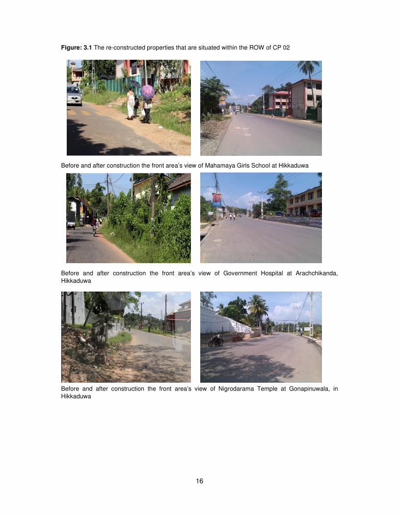
Figure: 3.1 The re-constructed properties that are situated within the ROW of CP 02
Before and after construction the front area’s view of Mahamaya Girls School at Hikkaduwa
Before and after construction the front area’s view of Government Hospital at Arachchikanda,
Hikkaduwa
Before and after construction the front area’s view of Nigrodarama Temple at Gonapinuwala, in
Hikkaduwa
17
3.3. CP-03 ALUTHGAMA (53+480) - SOUTHERN EXPRESSWAY (42+640) ROAD
Information of Resettlement plan
The project road section of, Horana-Anguruwatota-Aluthgama road (B 157) runs through a
semi-urban and agricultural area, and hence the influence area is reasonably rich in
human settlements and commercial establishments. As per the information available with the ATs and PPS prepared by the Dept. of Survey for this road, portions of land within 632 lots
have to be acquired. The total area extent of 632 lots is 3026.0 perches. The entire land
extent of this road section is located within Beruwala and Mathugama DS divisions of
Kalutara district.
Table 3.9 Distribution of affected land lots among DSDs
District DSD No. of Affected
Lots
Affected Area
( perches)
Kalutara Beruwala 282 789.6
Mathugama 350 2236.4
Total 632 3026.0
Source: ATs and PPs prepared on the request of respective acquisition officers by the Dept. of Survey (2011)
IImmppaacctt ttoo PPrriivvaattee llaanndd aanndd SSttrruuccttuurreess
The impacts of acquiring private lands have far more effect on DPs compared to acquiring public/ common property land. Thus the RP made special focus on private lands affected by
the acquisition in view of taking appropriate measures to mitigate negative impacts falling on
private individuals.
Table 3.10 Number of households and lots acquired disaggregated by type of use - Private lands
Type of use No. of
Lots %
No. of
DHs %
Affected
Area
(perches)
%
Beruwala
Residential 131 21.37 122 22.34 318.6 10.86
Commercial 101 16.48 94 17.22 237.2 8.09
Agricultural 24 3.92 16 2.93 115.9 3.95
Non Agricultural 15 2.45 15 2.75 68 2.32
Access Roads 3 0.49 3 0.55 5.4 0.18
Sub Total 274 44.70 250 45.79 745.1 25.41
Mathugama
Residential 183 29.85 154 28.21 801 27.31
Commercial 86 14.03 81 14.84 345.3 11.77
Agricultural 42 6.85 33 6.04 457.6 15.60
Non Agricultural 27 4.40 27 4.95 581.8 19.84
Access Roads 1 0.16 1 0.18 1.8 0.06
Sub Total 339 55.30 296 54.21 2187.5 74.59
18
Type of use No. of
Lots %
No. of
DHs %
Affected
Area
(perches)
%
Grand Total 613 100 546 100 2932.6 100
Source: ATs and PPs prepared on the request of respective acquisition officers by the Dept. of Survey (2011)
A majority of land lots to be acquired are commercial and residential properties amounting to
around 81.73 percent of the land lots and 60 percent in area extent under private ownership. The resettlement implications with these land lots are that their values are high and mostly
owned by economically and socially wealthier group of people whose expectations and
aspirations are also high with regard to restoration of their lives. The next highest land use is
seen with agriculture activities with the use of 10.77% of lots with an extent of 19.55% of lands in extent to be acquired, amounting to 573.5 perches. The agricultural lands are mainly
paddy and rubber. The land use for non-agriculture is not very prominent along this road as
its only 6.85% with 22.16% of the total land extent, representing 649.8 perches. The non-
agriculture lots cover an area without a house or any other structure, but may have trees or bare land portions without generating any income. In a sense, they are potential
land lots for future residential and commercial uses.
Table 3.11 Summary of Land Acquisition/Resettlement Impacts
Impact Extent
Affected Unit No of DHs
Permanent loss of private Residential/Commercial land
10% or less of land affected 303
Perch
300
11-50% of land affected 267.8 113
50% -99%of land affected 316.3 80
100% of land affected 815 20
Permanent loss of Agricultural/Non Agricultural/Access Road land
10% or less of land affected 109.6
Perch
20
11-50% of land affected 289.7 18
50% -99%of land affected 321 28
100% of land affected 510 11
Loss of Structures
Shops 80
No of
Structures
67
Houses 69 6
Shop Houses 39 36
Other secondary structures
(Parapet walls, toilets, tombs, wells,
huts…etc.)
117 71
Relocation
19
Impact Extent
Affected Unit No of DHs
Shops 3 No of
Structures
3
Houses 1 1
Shop Houses 0 0
Permanent loss of Livelihood
Owners of displaced shops 11 Persons
11
Workers from displaced shops 37 37
Loss of crops/trees 3028 Trees/crop plants 188
Loss of rental accommodation 44 Persons 44
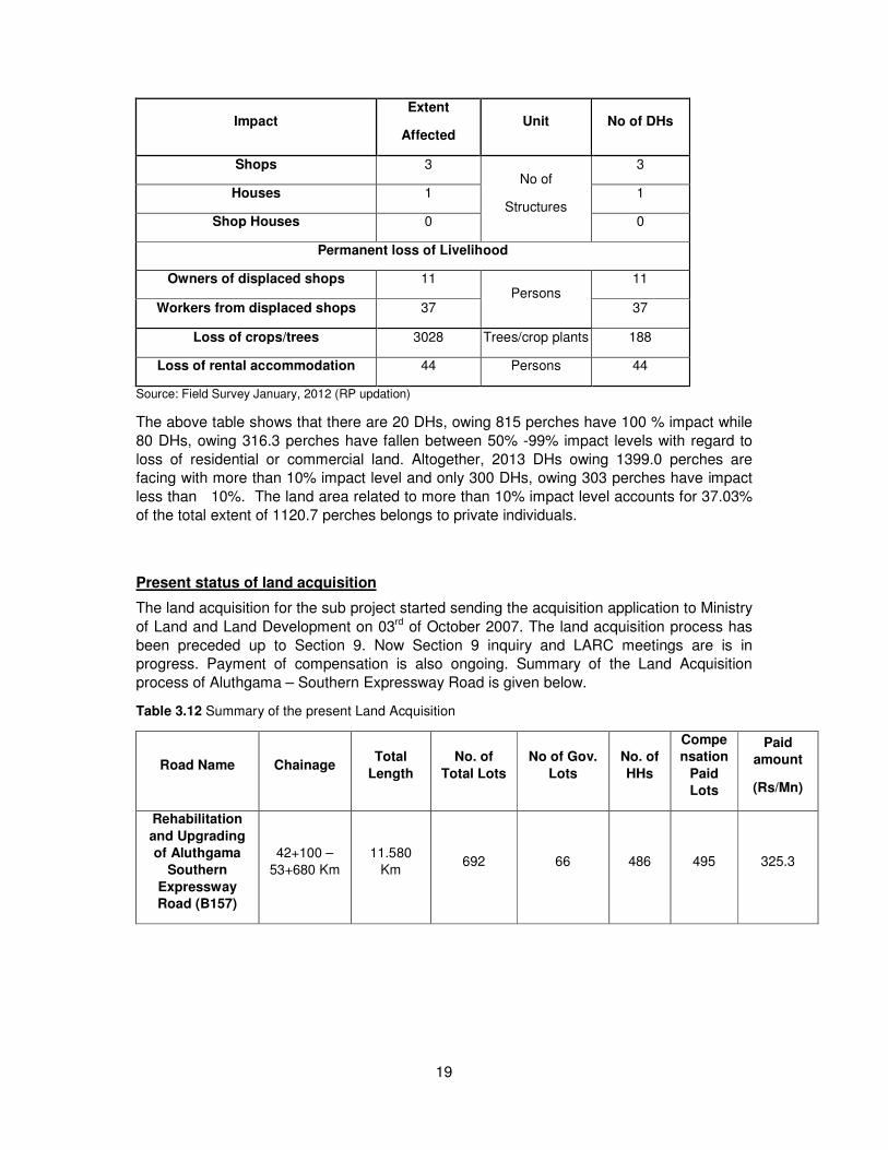
Source: Field Survey January, 2012 (RP updation)
The above table shows that there are 20 DHs, owing 815 perches have 100 % impact while
80 DHs, owing 316.3 perches have fallen between 50% -99% impact levels with regard to
loss of residential or commercial land. Altogether, 2013 DHs owing 1399.0 perches are facing with more than 10% impact level and only 300 DHs, owing 303 perches have impact
less than 10%. The land area related to more than 10% impact level accounts for 37.03%
of the total extent of 1120.7 perches belongs to private individuals.
Present status of land acquisition
The land acquisition for the sub project started sending the acquisition application to Ministry
of Land and Land Development on 03rd of October 2007. The land acquisition process has
been preceded up to Section 9. Now Section 9 inquiry and LARC meetings are is in progress. Payment of compensation is also ongoing. Summary of the Land Acquisition
process of Aluthgama – Southern Expressway Road is given below.
Table 3.12 Summary of the present Land Acquisition
Road Name Chainage Total
Length
No. of
Total Lots
No of Gov.
Lots
No. of
HHs
Compe
nsation
Paid
Lots
Paid
amount
(Rs/Mn)
Rehabilitation
and Upgrading
of Aluthgama
Southern
Expressway
Road (B157)
42+100 –
53+680 Km
11.580
Km 692 66 486 495 325.3
20
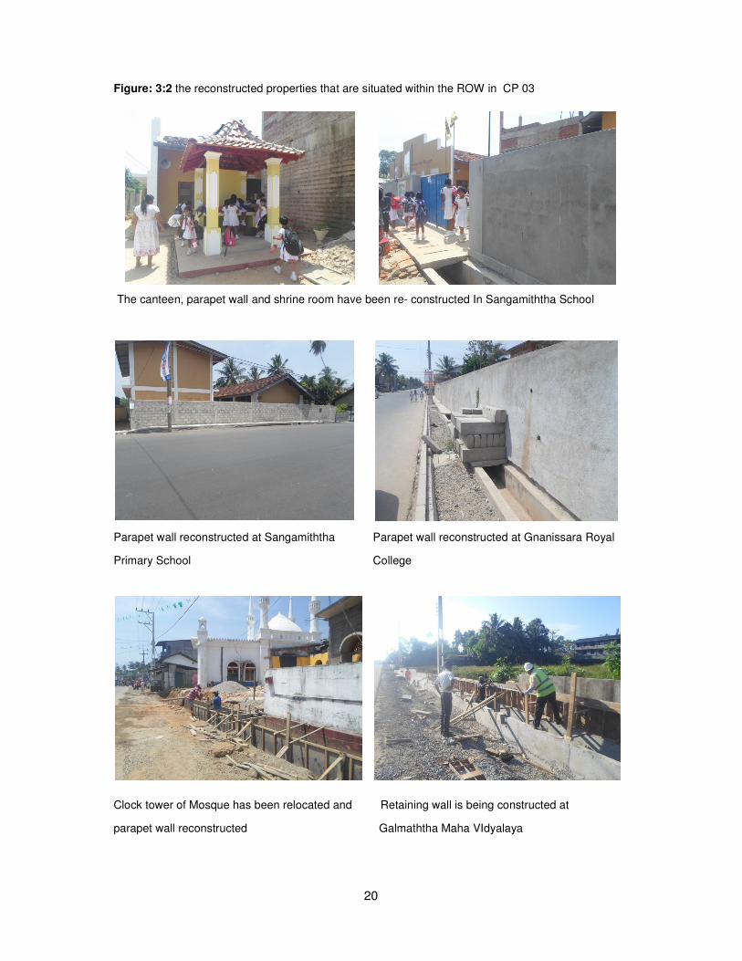
Figure: 3:2 the reconstructed properties that are situated within the ROW in CP 03
The canteen, parapet wall and shrine room have been re- constructed In Sangamiththa School
Parapet wall reconstructed at Sangamiththa Parapet wall reconstructed at Gnanissara Royal
Primary School College
Clock tower of Mosque has been relocated and Retaining wall is being constructed at
parapet wall reconstructed Galmaththa Maha VIdyalaya
21
3.4. CP-04 KATUKURUNDA (0+000) - NAGODA (2+720) ROAD
Information of Resettlement plan
The information available with the primary plans prepared by the Dept. of Survey for this road section indicates that 263 lots2 spreading over 429 perches will be acquired for this
road development project. This total land area is consisted of 386 perches of private lands, 9
perches of common land and 34 perches of government owned lands. Sections of structures
within the acquired portion of land will also be demolished for road improvement works. This entire land extent is located within Kalutara DS division of Kalutara district.
Table 3.13 Distribution of affected land lots among DSDs
DDiissttrriicctt DDSSDD NNoo.. ooff AAffffeecctteedd
LLoottss AAffffeecctteedd AArreeaa
(( ppeerrcchheess))
KKaalluuttaarraa KKaalluuttaarraa 226633 442299
Source: Preliminary Plans of Survey Dept. 2011
IImmppaacctt ttoo PPrriivvaattee llaanndd aanndd SSttrruuccttuurreess
Compared to acquiring public/ common property land, impacts of acquiring private lands
have a far more effect on the DPs. Thus the RP made special focus on private lands
affected by the acquisition in view of taking appropriate measures to mitigate negative
impact falling on private individuals. Thus table below is given the distribution of private
lands on different uses.
Table 3.14 Number of households and lots acquired disaggregated by type of use - Private lands
Type No. of
Lots %
No. of
HHs %
Affected
Area
(perches)
%
Residential 77 32.6 75 33.3 142.2 36.8
Commercial 137 58.0 128 56.8 193.9 50.2
Agricultural 4 1.6 4 1.7 15.6 4.0
Non Agricultural 18 7.6 18 8 34.0 8.8
Total 236 100 225 100 385.8 100
Source: Field Survey June, 2011 (RP updation)
A great majority of land lots to be acquired are commercial and residential properties
amounting to 90.6 percent of the land lots under private ownership. These lots represent
87.0 per cent of the area in extent earmarked for acquisition. The resettlement implication
with these land lots are that their values are high and mostly owned by economically and
socially better off group of people whose expectations and aspirations are also high with
increased demand for restoration of their lives. The land use for agricultural purpose accounts for 1.6 per cent of the lots with 4.0 per cent area representation, accounting for 1.6
perches. This shows relative insignificance of agricultural land use in the area, being its
predominance in commercial activities. Similarly, land use for non-agriculture purposes looks
meager in the project area showing only 7.6 per cent of land lots for the said purpose. The non-agriculture lot covers an area without a house or any other structure, but may have trees
or bare land portions without generating any income.
22
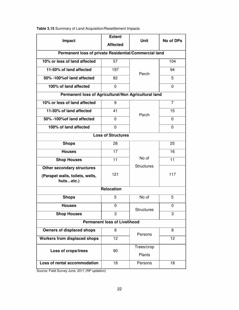
Table 3.15 Summary of Land Acquisition/Resettlement Impacts
Impact Extent
Affected Unit No of DPs
Permanent loss of private Residential/Commercial land
10% or less of land affected 57
Perch
104
11-50% of land affected 197 94
50% -100%of land affected 82 5
100% of land affected 0 0
Permanent loss of Agricultural/Non Agricultural land
10% or less of land affected 9
Perch
7
11-50% of land affected 41 15
50% -100%of land affected 0 0
100% of land affected 0 0
Loss of Structures
Shops 28
No of
Structures
25
Houses 17 16
Shop Houses 11 11
Other secondary structures
(Parapet walls, toilets, wells,
huts…etc.)
121 117
Relocation
Shops 5 No of 5
Houses 0 Structures
0
Shop Houses 3 3
Permanent loss of Livelihood
Owners of displaced shops 8 Persons
8
Workers from displaced shops 12 12
Loss of crops/trees 90 Trees/crop
Plants
Loss of rental accommodation 18 Persons 18
Source: Field Survey June, 2011 (RP updation)
23
The above table shows that there are no DPs with 100 % impact with regard to loss of
residential or commercial land, and 104 DPs, owing 57 perches have less significant impact
affecting less than 10% loss to their land in this category. However, still 99 DPs owing 279 perches are fallen over 10% impact level with regard to the losses incurred to their
residential and commercial land. The land affected over 10% impact level (279 perches)
accounts for 72.2% of the total land area (385.8 perches) under residential and commercial
category. This is a significant loss for a large number of DPs and they need resettlement support to re-establish their affected lives.
Displaced Persons amounting to 52 have lost 56 primary structures in the categories of
shops, houses and shop cum houses while 117 DPs have lost secondary structures like
parapet walls, toilets and wells etc. Five (5) shops and three (3) shop-houses belonged to
eight (8) DPs need relocation. 20 DPs (12 paid workers and 8 shop owners) have lost their
livelihood permanently due to displacing of their shops. 18 DPs loose rental accommodation.
Present status of Land acquisition
The land acquisition for the sub project started sending the acquisition application to Ministry of Land and Land Development on 16th of August 2007. The land acquisition process has
been completed. The LARC meetings and payment of compensation are almost all
completed. Summary of the Land Acquisition process of Nagoda - Katukurunda Road is
given below.
Table 3.16 Summary of the present Land Acquisition
Road Name Chainage Total
Length
No. of
Total Lots
No of Gov.
Lots
No. of
HHs
Compen
sation
Paid
Lots
Paid
amount
(Rs/Mn)
Rehabilitation
and Upgrading
of Nagoda –
Katukurunda
Road (B207)
0+000 –
2+720 Km 2.720 Km 263 20 225 243 211.2
33..55 CCPP--0055 KKIIRRUULLAAPPAANNEE ((00++000000)) -- HHOOMMAAGGAAMMAA ((1155++550000)) RROOAADD
Information of Resettlement Plan
Kirulapona – Homagama section of A 004 road runs through a densly populated and
urbanized area, and hence the influence area of the project is rich in housing stock and commercial establishments. Considering the impact to the society (economic and social
impacts) and the urgency of developing the road section, the designs were completed in
such a way that four operational lanes could be accommodated within the available Right of
Way (ROW).
This road section is located within the DS divisions of Timbirigasyaya, Dehiwala, Kotte,
Maharagama and Homagama. Although land acquisition was not required few impacts to the
public occurred during construction. These issues were resolved through GRC.
24
33..66 CCPP--0077 PPAAMMAANNKKAADDAA ((00++552200)) -- KKEESSBBEEWWAA ((1133++440000)) RROOAADD
Information of resettlement plan
The project road, i.e the section from Pamankada to Kesbewa of Colombo-Horana (B 084) road runs through densely populated urban and semi urban areas, and hence the influence
area is reasonably rich in human settlements and commercial establishments. As per the
information available with the ATS and PPs prepared by the Dept. of Survey for this road
section, 1532 lots have to be acquired. The total area extent of 1532 lots is 7337.4 perches; consisting of private individuals owned 1404 lots with 6822.3 perches, corporately owned 27
lots with 99.2 perches, commonly owned 24 lots with 132.5 perches and government
agencies owned 77 lots with 283.5 perches.
This entire land extent of this road section is located within Thimbirigasyaya, Dehiwala and
Kesbewa DS divisions of Colombo district.
Table 3.17 Distribution of affected land lots among DSDs
District DSD No. of Affected
Lots
Affected Area
( perches)
Colombo
Thimbirigasyaya 90 278.5
Dehiwala 341 875.4
Kesbewa 1101 6183.6
Total 1532 7337.5
Source: Advance Tracing/Preliminary Plans prepared on the request of respective acquisition officers by The Dept. of Survey (2011)
IImmppaacctt ttoo PPrriivvaattee LLaanndd aanndd SSttrruuccttuurreess
The impacts of acquiring private lands have far more effect on DPs compared to acquiring
public/ common property land. Thus the RP made special focus on private lands affected by
the acquisition in view of taking appropriate measures to mitigate negative impacts falling on
private individuals. Thus table below is gives the distribution of private lands on different
uses.
Table 3.18 Number of households and lots acquired disaggregated by type of use - Private owned
lands
Type of use No. of
Lots %
No. of
DHs %
Affected
Area
(perches)
%
Thibirigasyaya
Residential 24 1.7 23 1.8 107.3 1.6
Commercial 49 3.5 46 3.4 124.8 1.8
Agricultural 0 0 0 0 0 0
Non Agricultural 0 0 0 0 0 0
Access Roads 10 0.7 10 0.7 10.6 0.1
Sub Total 83 5.9 79 5.9 242.7 3.5
Dehiwala
Residential 47 3.3 46 3.4 119.3 1.8
Commercial 228 16.2 210 15.6 633.4 9.2
25
Agricultural 0 0 0 0 0 0
Non Agricultural 5 0.4 5 0.5 15.3 0.3
Access Roads 44 3.1 44 3.2 51.6 0.7
Sub Total 324 23.0 305 22.7 819.6 12.0
Kesbewa
Residential 222 15.8 216 16.1 1152.5 16.9
Commercial 636 45.3 610 45.6 1843.5 27.0
Agricultural 83 5.9 75 5.6 2207.6 32.4
Non Agricultural 32 2.3 31 2.4 316.6 4.6
Access Roads 24 1.7 22 1.6 239.8 3.5
Sub Total 997 71.0 954 71.3 5760.0 84.4
Grand Total 1404 100 1338 100 6822.3 100
Source: Advance Tracing/Preliminary Plans prepared for B084 road and Field Survey October, 2011
A large number of land lots to be acquired are commercial and residential properties
amounting to around 85.9 percent of the land lots and 58.3 percent in area extent under
private ownership. The higher percentage value in land lots (85.9%) and comparatively less percentage value in area extent (58.3%) represent smallness of area extent of individual lots
located in urban and semi-urban areas. Land is the most scare resource in the affected area.
The average size of an individual land lot in project area spread over three DSDs is small as
4.8 perches. The resettlement implications with these land lots are that their values are high and mostly owned by economically and socially better off group of people whose
expectations and aspirations are also high with regard to restoration of their lives. The next
land uses such as agriculture, non-agriculture and access roads play a comparatively low
role occupying 5.9%, 2.6% and 5.5% respectively. The non-agriculture lots cover an area
without a house or any other structure, but may have trees or bare land portions without
generating any income. In a sense, they are potential land lots for future residential and
commercial uses. As land use for agriculture purposes are not very prominent along public
roads running through human settlements, only 5.9% of land lots are recorded being used for agricultural purposes with 32.3% of the total land extent, representing 2207.6 perches.
Unlike to residential and commercial lots, the size of agriculture lots is comparatively larger
showing an average extent of 26.5 perches. The agriculture (paddy) land use is seen only in
Kesbewa DS division which is the end section of the road towards Horana away from Colombo, approaching country side gradually.
Table 3.19 Summary of Land Acquisition/Resettlement Impacts
Impact Extent
Affected Unit No of DHs
Permanent loss of private Residential/Commercial land
10% or less of land affected 513.0
Perch
444
11-50% of land affected 1181.6 426
50% -100%of land affected 1131.4 221
100% of land affected 1154.8 65
Permanent losses of Agricultural/Non Agricultural land
10% or less of land affected 60.3 Perch 66
26
Impact Extent
Affected Unit No of DHs
11-50% of land affected 66.2 24
50% -100%of land affected 90.5 16
100% of land affected 2624.5 82
Loss of Structures
Shops 488
No of
Structures
456
Houses 180 168
Shop Houses 120 103
Other secondary structures
(Parapet walls, toilets, wells,
huts…etc.)
878 807
Relocation
Shops 67 No of
Structures
65
Houses 28 27
Shop Houses 15 13
Permanent loss of Livelihood
Owners of displaced shops 78 Persons
78
Workers from displaced shops 54 54
Loss of crops/trees 275 Trees/crops 57
Loss of rental accommodation 384 Persons 384
Source: Advance Tracing/Preliminary Plans prepared for B084 road and Field Survey October,2011
The above table shows that there are 65 DHs, owing 1154.8 perches have 100 % impact
while 647 DHs, owing 2213 perches have fallen between 11% -100% impact levels with
regard to loss of residential or commercial land. In altogether, 712 DHs (53.2% of DHs), owing 3467.8 perches are facing with more than 10% impact level, and only 444 DHs, owing
513 perches have impact less than 10%. The land area related to more than 10% impact
level accounts for 51.0% of the total extent of 6822.3 perches belong to private individuals;
requiring adequate interventions to mitigate adverse effects falling on DHs.
PPeerrmmaanneenntt lloosssseess ooccccuurrrriinngg ttoo aaggrriiccuullttuurraall//nnoonn aaggrriiccuullttuurraall llaannddss,,
2781.2 perches owing to 122 DHs will have more than 10% impact level while only 60.3 perches owing to 66 DHs will have impact less than 10%. The land area under
agricultural/non agricultural use having more than 10% impact level accounts for 40.7% of
the total private land to be acquired. Although agricultural and non agricultural lands contain
sizable portion (40.7%) of the total extent of private land, this portion is owned by only 8.5% of the total DHs units (1404). This disproportional relationship between the extent of land
and the number of owners reminds us the smallness of land available for residential and
commercial purposes and the use of more land per unit of agricultural production. Agriculture
27
being a land base production system, it needs more land for a production unit than for non-
farm activity.
Displaced Households amounting to 727 have lost 788 primary structures in the categories
of shops, houses and shop cum houses while 807 DHs have lost 878 units of secondary
structures like parapet walls, toilets and wells etc. As revealed in the survey, 67 shops belong to 65 DHs, 28 houses belong to 27 DHs, and 15 shops cum houses belong to 13
DHs need relocation. Permanent displacement will occur to 78 shops belong to 78 DHs and
54 workers belong to 54 DHs. Rental accommodation is lost for 384 DHs. The loss of trees
is around 275 belong to 57 DHs. Apparently, PMU has taken precautionary measures to
minimize adverse effect of the project, and therefore need for relocation elsewhere has been
reduced to 110 units of houses, shops and shop cum houses (all primary structures) belong
to 105 DHs, out of 1338 total DH units, representing a small fraction as 7.8% of the total DHs
units.
Present status of land acquisition
The land acquisition for the sub project started sending the acquisition application to Ministry of Land and Land Development on 30th of January 2008. The land acquisition process has
been preceded up to Section 9. Now Section 9 inquiry and LARC meetings are is in
progress. Payment of compensation is also ongoing. Summary of the Land Acquisition
process of Pamankada - Kesbewa Road is given below.
Table 3.20 Summary of the present Land Acquisition
RRooaadd NNaammee CChhaaiinnaagg
ee TToottaall
LLeennggtthh NNoo.. ooff
TToottaall LLoottss NNoo ooff GGoovv..
LLoottss NNoo.. ooff HHHHss
CCoommppeennss
aattiioonn PPaaiidd LLoottss
PPaaiidd aammoouunntt ((RRss//MMnn))
RReehhaabbiilliittaattiioonn aanndd UUppggrraaddiinngg ooff
PPaammaannkkaaddaa -- KKeessbbeewwaa RRooaadd
((AA000044))
00++552200 –– 1133++880000
KKmm
1133..228800 KKmm
11887799 445522 11333388 11225577 11773366..77
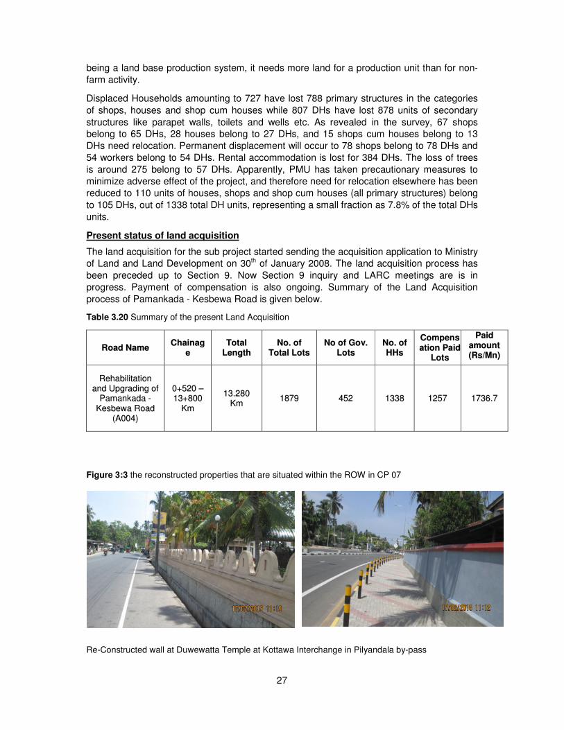
Figure 3:3 the reconstructed properties that are situated within the ROW in CP 07
Re-Constructed wall at Duwewatta Temple at Kottawa Interchange in Pilyandala by-pass
28
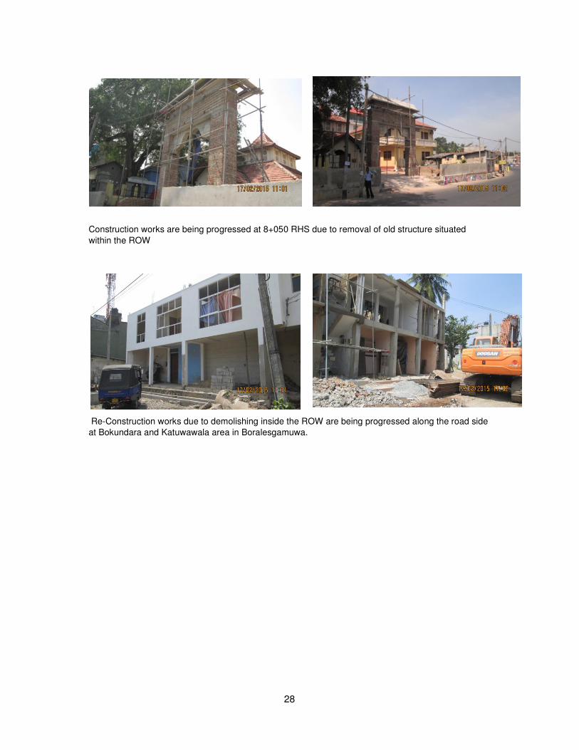
Construction works are being progressed at 8+050 RHS due to removal of old structure situated
within the ROW
Re-Construction works due to demolishing inside the ROW are being progressed along the road side
at Bokundara and Katuwawala area in Boralesgamuwa.
29
4 INCOME RESTORATION PROGRAMS (IRP)
Main purpose of IRP is to mitigate the impact on the livelihoods of the displaced families
(DFs) caused by the road development projects. During this programs the IRP team (Income Restoration and Monitoring Specialists, Social Mobilizer, Business Development Officer and
other vocational trainers) has given priority for the women because they have identified
women and children as the mostly affected group by the road development project.
The activity of restoring income of displaced families is a time consuming process. The
training can be either business development or vocational training. Relevant member is
mostly unemployed female member of DF and therefore women participation was more for
IRP (According to Sri Lanka Labour force survey Female employment rate is higher than male unemployment population.)
The IRP mainly serves the low income earning DFs. When alleviating poverty of DFs microfinance programs play a significant role, which is also common for this program.
Therefore IRP team has included micro –finance component in to the program and all the
micro finance facilities available in Sri Lanka uses Bangladesh’s “Grameen” model with slight
modifications.
i. Income Restoration Programme of Pamankada-Kesbewa Road
The Income Restoration Programme for Pamankada – Kesbewa Road has been started on 2nd of September 2013. The programme is being conducted by the consultant hired by the
project. The progress of work is mentioned below;
ii. Completed tasks
The Consultant has conducted pilot and Social, Economic Survey. They have collected
details from the 1196 land owners and 161 families were given their consent for livelihood
trainings.
The Consultant has conducted further discussion with the selected 161 families to obtain
their expectation form for the livelihood trainings.
Business Development officer and social development officer have met needy families
regularly and discussed their social and business problems.
A programme office has been setup at Katuwawala and a training center at Papiliyana
Samurdhi Bank premises
According to the training plan prepared by the Income Restoration team, the livelihoods development training programme has commenced.
Table 4:1 the summary of the progresses of the trainings are as follows
S.N Theme of the training Number of seasons
Expected participations
Average participation
1 Saree Jackets sewing 08 20 18
2 Mobile phone repairing and LED bulb production
05 10 09
30
3 Ladies shoe production 03 20 18
4 Mosquito net production 02 15 29
5 English language for livelihoods 16 15 19
6 Tailoring 24 20 18
7 Information Technology 48 05 05
8 Beauty culture 48 15 01
9 School bag production 03 15 10
iii. Linkage building with displaced families
Following links have been built by the Income Restoration team during past few months
• 15 families linked to the Samurdhi Authority of Sri Lanka (Samurdhi Bank ) for Micro Finance. Samurdhi bank has taken steps to issue Rs 25,000/= as a livelihood development loan under low interest and group collateral
• 30 families linked to the whole sale dealers for purchase of raw materials for shoe production, mosquito net production and LED bulb production.
• 3 displaced family members were linked to technicians to repair their sewing machines.
• 6 displaced families directed to the Resettlement unit of National Highway Sector project to solve their land problems
• A vulnerable family linked to the government poverty alleviation programme (Samurdhi) and the manager of the relevant Samurdhi bank has given his consent to help this family
• The Income Restoration Team has discussed to make a linkage about Tissue Culture with Department of Botanical Gardens.
iv. Future Plans
1. Following livelihood training programme are expect to conduct
S.N. Theme of the training Potential participation of Af
members 1 Light vehicle driving 20 2 Orchid cultivation 15 3 Screen printing 10 4 Beauty Culture 12 5 Food technology 10
2. To revise the training plan according to the displaced family members livelihoods training needs and to be implemented from month of May.
31
3. To start a process for making awareness about the Income Restoration programme for displaced families, those who have not participated in the livelihood trainings via the participated neighbor displaced families.
v. Success Stories
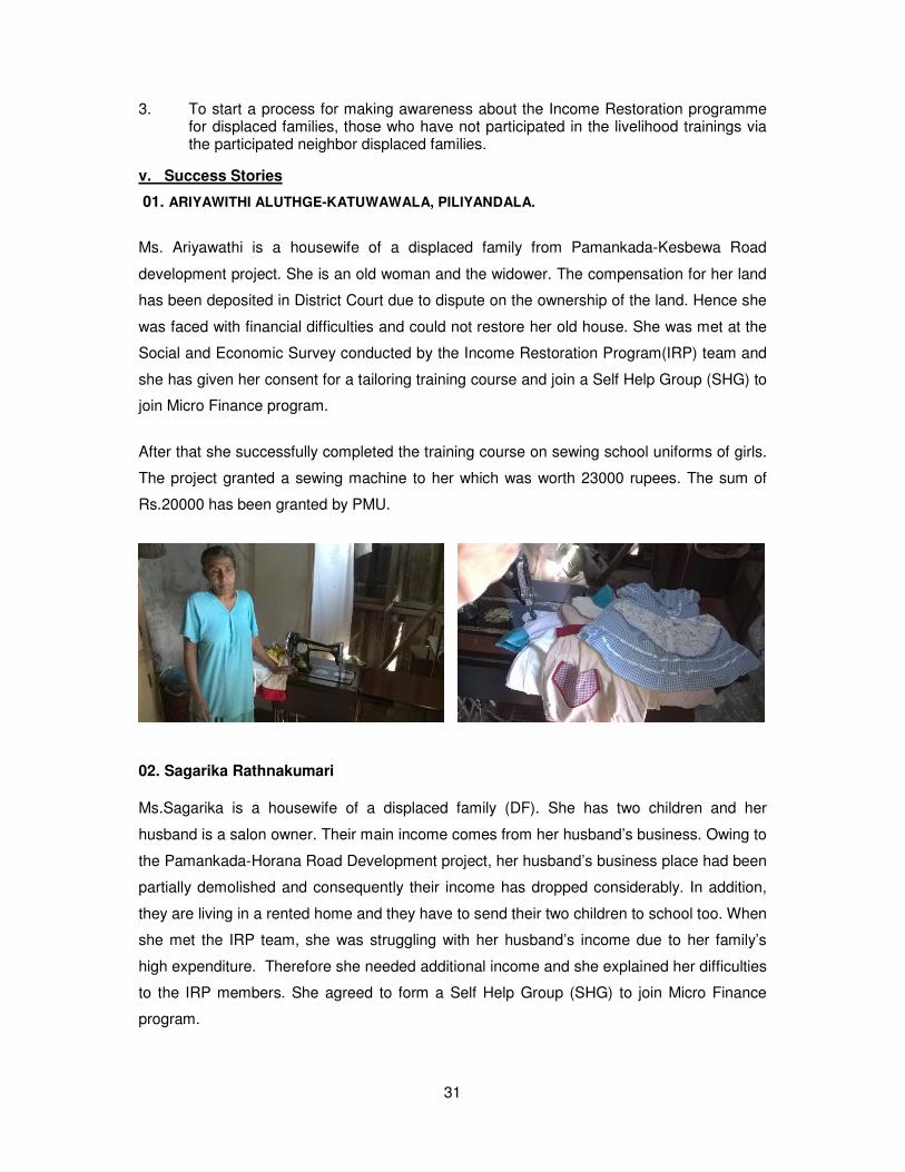
01. ARIYAWITHI ALUTHGE-KATUWAWALA, PILIYANDALA.
Ms. Ariyawathi is a housewife of a displaced family from Pamankada-Kesbewa Road
development project. She is an old woman and the widower. The compensation for her land
has been deposited in District Court due to dispute on the ownership of the land. Hence she
was faced with financial difficulties and could not restore her old house. She was met at the
Social and Economic Survey conducted by the Income Restoration Program(IRP) team and
she has given her consent for a tailoring training course and join a Self Help Group (SHG) to
join Micro Finance program.
After that she successfully completed the training course on sewing school uniforms of girls.
The project granted a sewing machine to her which was worth 23000 rupees. The sum of
Rs.20000 has been granted by PMU.
02. Sagarika Rathnakumari
Ms.Sagarika is a housewife of a displaced family (DF). She has two children and her
husband is a salon owner. Their main income comes from her husband’s business. Owing to
the Pamankada-Horana Road Development project, her husband’s business place had been
partially demolished and consequently their income has dropped considerably. In addition,
they are living in a rented home and they have to send their two children to school too. When
she met the IRP team, she was struggling with her husband’s income due to her family’s
high expenditure. Therefore she needed additional income and she explained her difficulties
to the IRP members. She agreed to form a Self Help Group (SHG) to join Micro Finance
program.
32
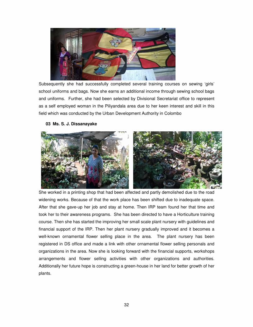
Subsequently she had successfully completed several training courses on sewing ‘girls’
school uniforms and bags. Now she earns an additional income through sewing school bags
and uniforms. Further, she had been selected by Divisional Secretariat office to represent
as a self employed woman in the Piliyandala area due to her keen interest and skill in this
field which was conducted by the Urban Development Authority in Colombo
03 Ms. S. J. Dissanayake
She worked in a printing shop that had been affected and partly demolished due to the road
widening works. Because of that the work place has been shifted due to inadequate space.
After that she gave-up her job and stay at home. Then IRP team found her that time and
took her to their awareness programs. She has been directed to have a Horticulture training
course. Then she has started the improving her small scale plant nursery with guidelines and
financial support of the IRP. Then her plant nursery gradually improved and it becomes a
well-known ornamental flower selling place in the area. The plant nursery has been
registered in DS office and made a link with other ornamental flower selling personals and
organizations in the area. Now she is looking forward with the financial supports, workshops
arrangements and flower selling activities with other organizations and authorities.
Additionally her future hope is constructing a green-house in her land for better growth of her
plants.
33
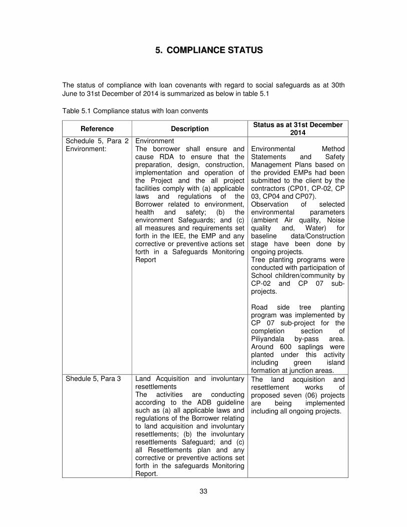
55.. CCOOMMPPLLIIAANNCCEE SSTTAATTUUSS
The status of compliance with loan covenants with regard to social safeguards as at 30th
June to 31st December of 2014 is summarized as below in table 5.1
Table 5.1 Compliance status with loan convents
Reference Description Status as at 31st December
2014 Schedule 5, Para 2 Environment:
Environment The borrower shall ensure and cause RDA to ensure that the preparation, design, construction, implementation and operation of the Project and the all project facilities comply with (a) applicable laws and regulations of the Borrower related to environment, health and safety; (b) the environment Safeguards; and (c) all measures and requirements set forth in the IEE, the EMP and any corrective or preventive actions set forth in a Safeguards Monitoring Report
Environmental Method Statements and Safety Management Plans based on the provided EMPs had been submitted to the client by the contractors (CP01, CP-02, CP 03, CP04 and CP07). Observation of selected environmental parameters (ambient Air quality, Noise quality and, Water) for baseline data/Construction stage have been done by ongoing projects. Tree planting programs were conducted with participation of School children/community by CP-02 and CP 07 sub- projects. Road side tree planting program was implemented by CP 07 sub-project for the completion section of Piliyandala by-pass area. Around 600 saplings were planted under this activity including green island formation at junction areas.
Shedule 5, Para 3
Land Acquisition and involuntary resettlements The activities are conducting according to the ADB guideline such as (a) all applicable laws and regulations of the Borrower relating to land acquisition and involuntary resettlements; (b) the involuntary resettlements Safeguard; and (c) all Resettlements plan and any corrective or preventive actions set forth in the safeguards Monitoring Report.
The land acquisition and resettlement works of proposed seven (06) projects are being implemented including all ongoing projects.
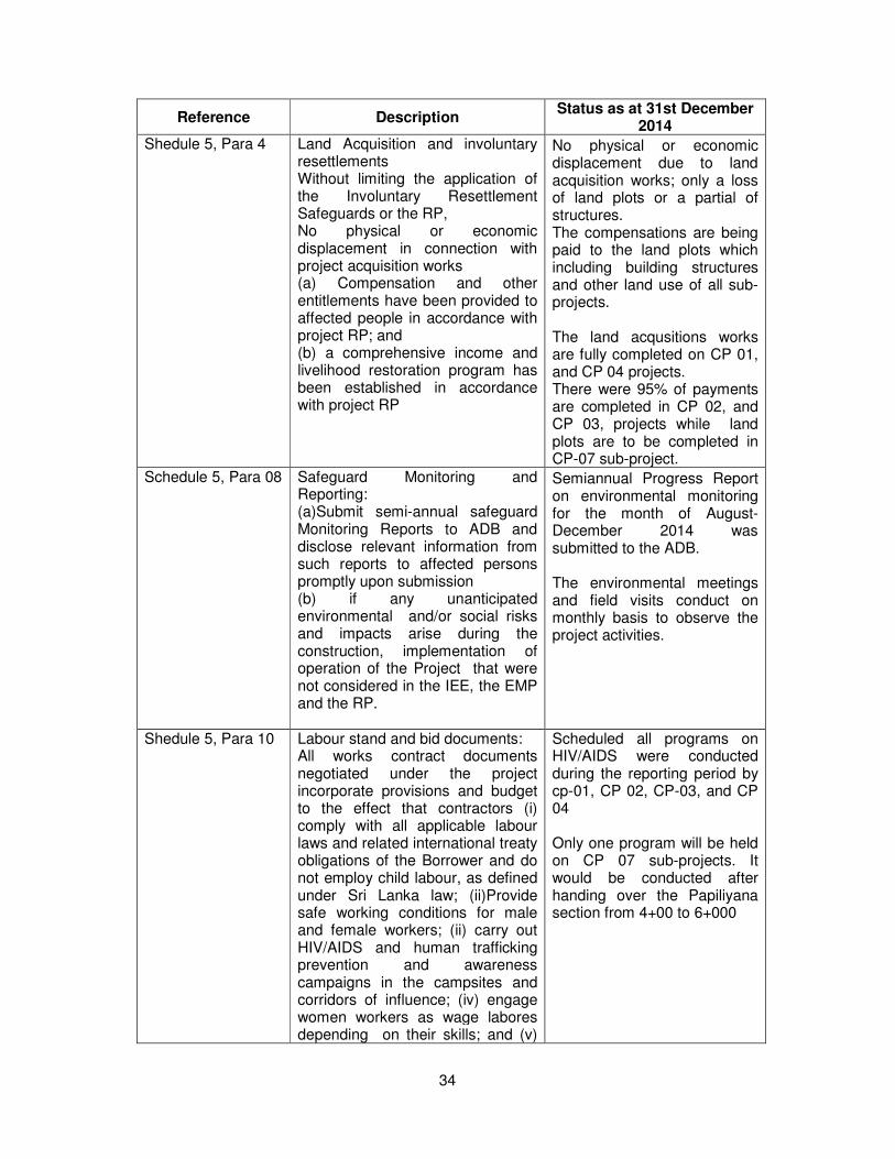
34
Reference Description Status as at 31st December
2014 Shedule 5, Para 4
Land Acquisition and involuntary resettlements Without limiting the application of the Involuntary Resettlement Safeguards or the RP, No physical or economic displacement in connection with project acquisition works (a) Compensation and other entitlements have been provided to affected people in accordance with project RP; and (b) a comprehensive income and livelihood restoration program has been established in accordance with project RP
No physical or economic displacement due to land acquisition works; only a loss of land plots or a partial of structures. The compensations are being paid to the land plots which including building structures and other land use of all sub-projects. The land acqusitions works are fully completed on CP 01, and CP 04 projects. There were 95% of payments are completed in CP 02, and CP 03, projects while land plots are to be completed in CP-07 sub-project.
Schedule 5, Para 08 Safeguard Monitoring and Reporting: (a)Submit semi-annual safeguard Monitoring Reports to ADB and disclose relevant information from such reports to affected persons promptly upon submission (b) if any unanticipated environmental and/or social risks and impacts arise during the construction, implementation of operation of the Project that were not considered in the IEE, the EMP and the RP.
Semiannual Progress Report on environmental monitoring for the month of August-December 2014 was submitted to the ADB. The environmental meetings and field visits conduct on monthly basis to observe the project activities.
Shedule 5, Para 10 Labour stand and bid documents: All works contract documents negotiated under the project incorporate provisions and budget to the effect that contractors (i) comply with all applicable labour laws and related international treaty obligations of the Borrower and do not employ child labour, as defined under Sri Lanka law; (ii)Provide safe working conditions for male and female workers; (ii) carry out HIV/AIDS and human trafficking prevention and awareness campaigns in the campsites and corridors of influence; (iv) engage women workers as wage labores depending on their skills; and (v)
Scheduled all programs on HIV/AIDS were conducted during the reporting period by cp-01, CP 02, CP-03, and CP 04 Only one program will be held on CP 07 sub-projects. It would be conducted after handing over the Papiliyana section from 4+00 to 6+000
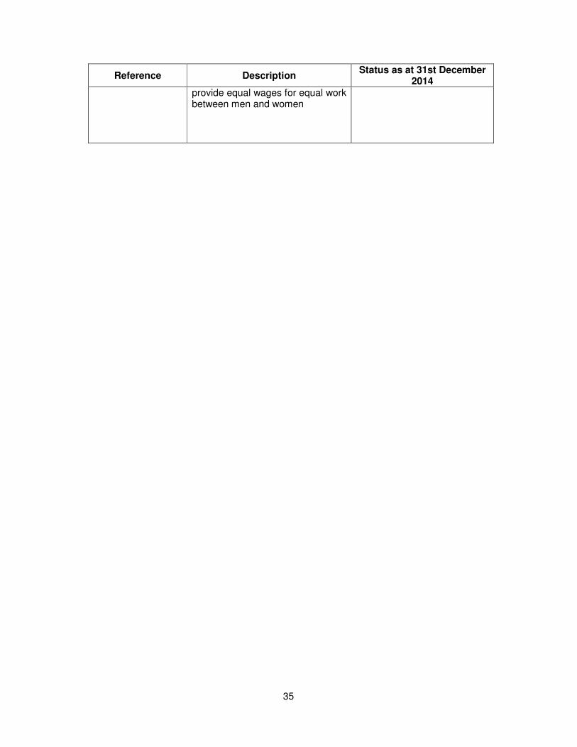
35
Reference Description Status as at 31st December
2014 provide equal wages for equal work between men and women