Embed Size (px)
Citation preview
DEFENSE LANGUAGE INSTITUTE
Geography
FOREIGN LANGUAGE CENTER
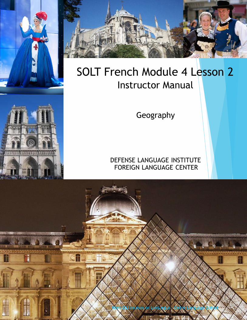
SOLT French Module 4 Lesson 2Instructor Manual
More DLI courses on LiveLingua - Online Language School

More DLI courses on LiveLingua - Online Language School
Geography French SOLT 1Introduction Module 4 Lesson 2
39
At the end of the lesson, you will be able to identify countries and nationalities in French-speaking Africa. You will learn about the geography, people, certain ethnic groups, and languages that make-up Francophone Africa. Recognize Countries and Locations of Francophone Africa
• Recognize location, the capital, and major cities of different African countries • Describe areas and borders of West Africa • Describe the geography of different countries in French-speaking Africa • Identify national flags of the countries in Francophone Africa • Talk about the location of the military installations • Brief about Francophone Africa
Identify Nationalities
• Identify languages in French-speaking Africa • Identify different ethnic groups • Describe demographic composition
More DLI courses on LiveLingua - Online Language School
Geography French SOLT 1Introduction Module 4 Lesson 2
40
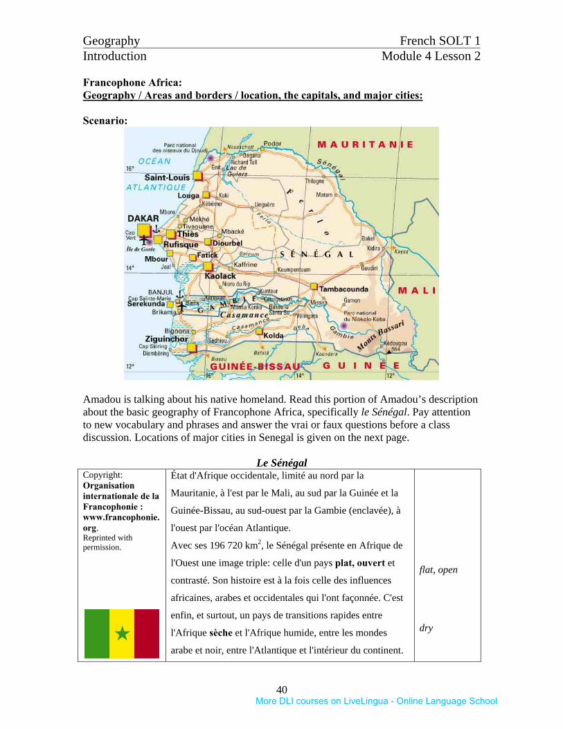
Francophone Africa: Geography / Areas and borders / location, the capitals, and major cities:
Scenario:
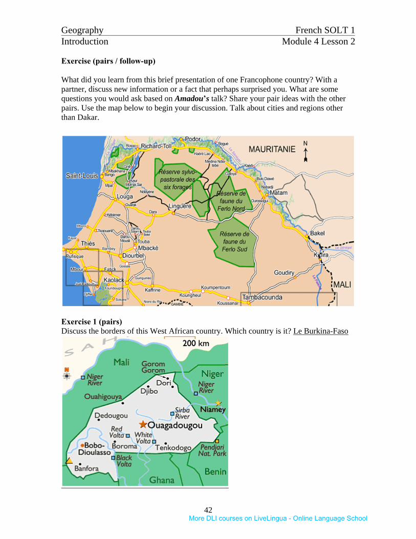
Amadou is talking about his native homeland. Read this portion of Amadou’s description about the basic geography of Francophone Africa, specifically le Sénégal. Pay attention to new vocabulary and phrases and answer the vrai or faux questions before a class discussion. Locations of major cities in Senegal is given on the next page.
Le Sénégal Copyright: Organisation internationale de la Francophonie : www.francophonie.org. Reprinted with permission.
État d'Afrique occidentale, limité au nord par la
Mauritanie, à l'est par le Mali, au sud par la Guinée et la
Guinée-Bissau, au sud-ouest par la Gambie (enclavée), à
l'ouest par l'océan Atlantique.
Avec ses 196 720 km2, le Sénégal présente en Afrique de
l'Ouest une image triple: celle d'un pays plat, ouvert et
contrasté. Son histoire est à la fois celle des influences
africaines, arabes et occidentales qui l'ont façonnée. C'est
enfin, et surtout, un pays de transitions rapides entre
l'Afrique sèche et l'Afrique humide, entre les mondes
arabe et noir, entre l'Atlantique et l'intérieur du continent.
flat, open
dry
More DLI courses on LiveLingua - Online Language School
Geography French SOLT 1Introduction Module 4 Lesson 2
41
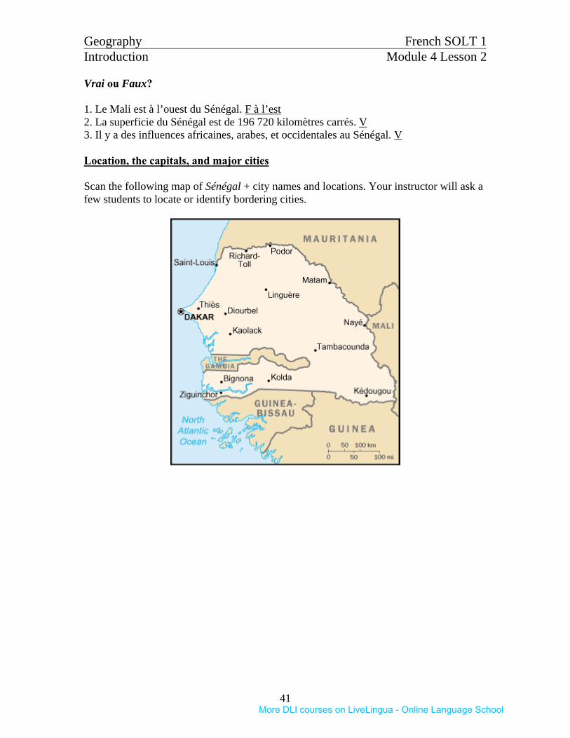
Vrai ou Faux? 1. Le Mali est à l’ouest du Sénégal. F à l’est 2. La superficie du Sénégal est de 196 720 kilomètres carrés. V 3. Il y a des influences africaines, arabes, et occidentales au Sénégal. V Location, the capitals, and major cities Scan the following map of Sénégal + city names and locations. Your instructor will ask a few students to locate or identify bordering cities.
More DLI courses on LiveLingua - Online Language School
Geography French SOLT 1Introduction Module 4 Lesson 2
42
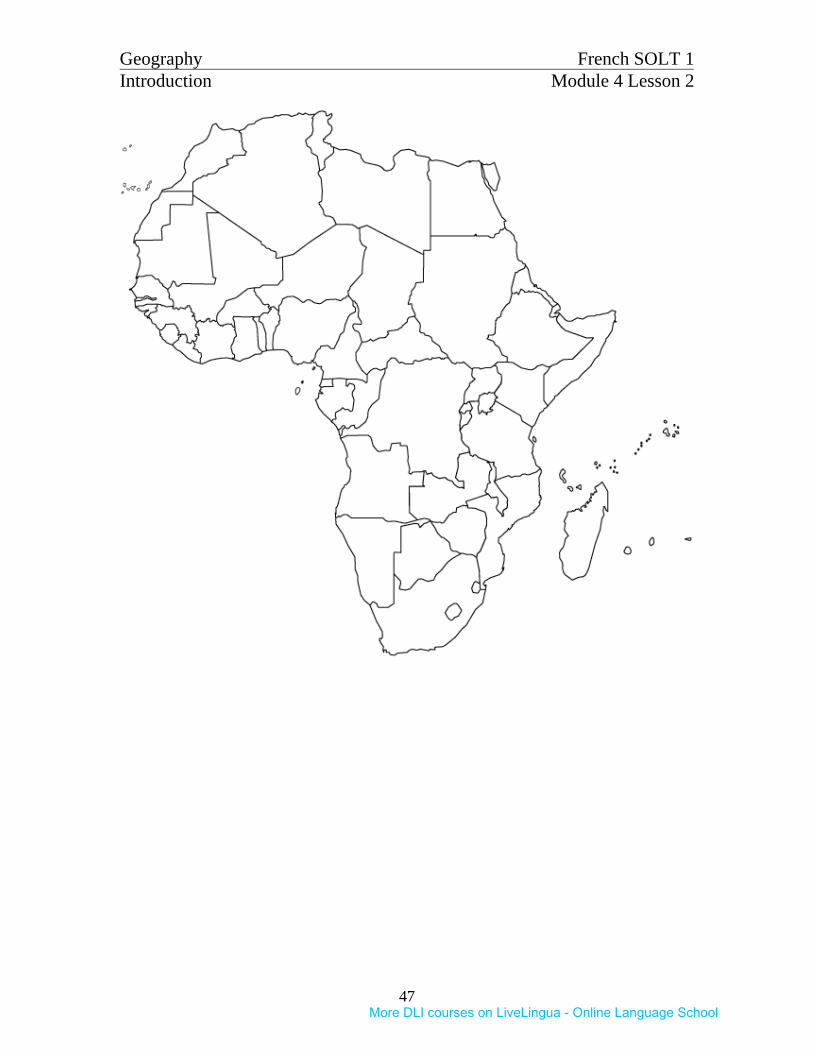
Exercise (pairs / follow-up) What did you learn from this brief presentation of one Francophone country? With a partner, discuss new information or a fact that perhaps surprised you. What are some questions you would ask based on Amadou’s talk? Share your pair ideas with the other pairs. Use the map below to begin your discussion. Talk about cities and regions other than Dakar.
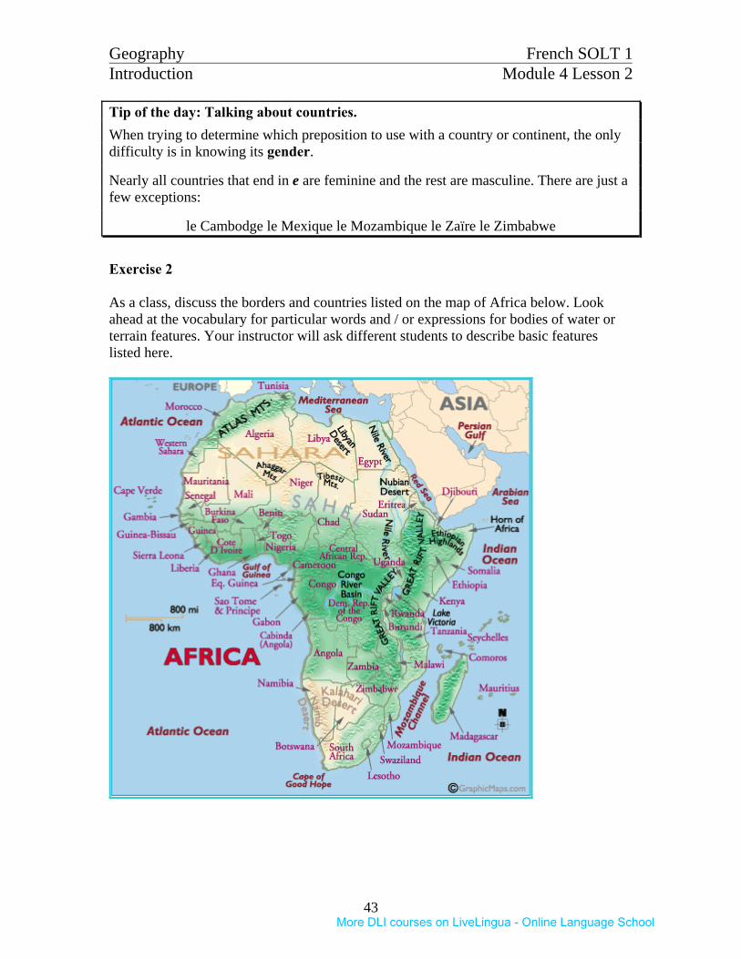
Exercise 1 (pairs) Discuss the borders of this West African country. Which country is it? Le Burkina-Faso
More DLI courses on LiveLingua - Online Language School
Geography French SOLT 1Introduction Module 4 Lesson 2
43
Tip of the day: Talking about countries. When trying to determine which preposition to use with a country or continent, the only difficulty is in knowing its gender.
Nearly all countries that end in e are feminine and the rest are masculine. There are just a few exceptions:
le Cambodge le Mexique le Mozambique le Zaïre le Zimbabwe
Exercise 2 As a class, discuss the borders and countries listed on the map of Africa below. Look ahead at the vocabulary for particular words and / or expressions for bodies of water or terrain features. Your instructor will ask different students to describe basic features listed here.
More DLI courses on LiveLingua - Online Language School
Geography French SOLT 1Introduction Module 4 Lesson 2
44
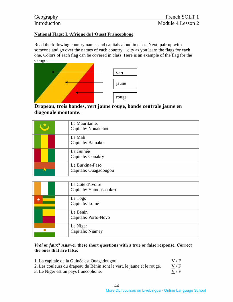
National Flags: L’Afrique de l’Ouest Francophone Read the following country names and capitals aloud in class. Next, pair up with someone and go over the names of each country + city as you learn the flags for each one. Colors of each flag can be covered in class. Here is an example of the flag for the Congo:
Drapeau, trois bandes, vert jaune rouge, bande centrale jaune en diagonale montante.
La Mauritanie. Capitale: Nouakchott
Le Mali Capitale: Bamako
La Guinée Capitale: Conakry
Le Burkina-Faso Capitale: Ouagadougou
La Côte d’Ivoire Capitale: Yamoussoukro
Le Togo Capitale: Lomé
Le Bénin Capitale: Porto-Novo
Le Niger Capitale: Niamey
Vrai or faux? Answer these short questions with a true or false response. Correct the ones that are false. 1. La capitale de la Guinée est Ouagadougou. V / F 2. Les couleurs du drapeau du Bénin sont le vert, le jaune et le rouge. V / F 3. Le Niger est un pays francophone. V / F
vert
jaune
rouge
More DLI courses on LiveLingua - Online Language School
Geography French SOLT 1Introduction Module 4 Lesson 2
45
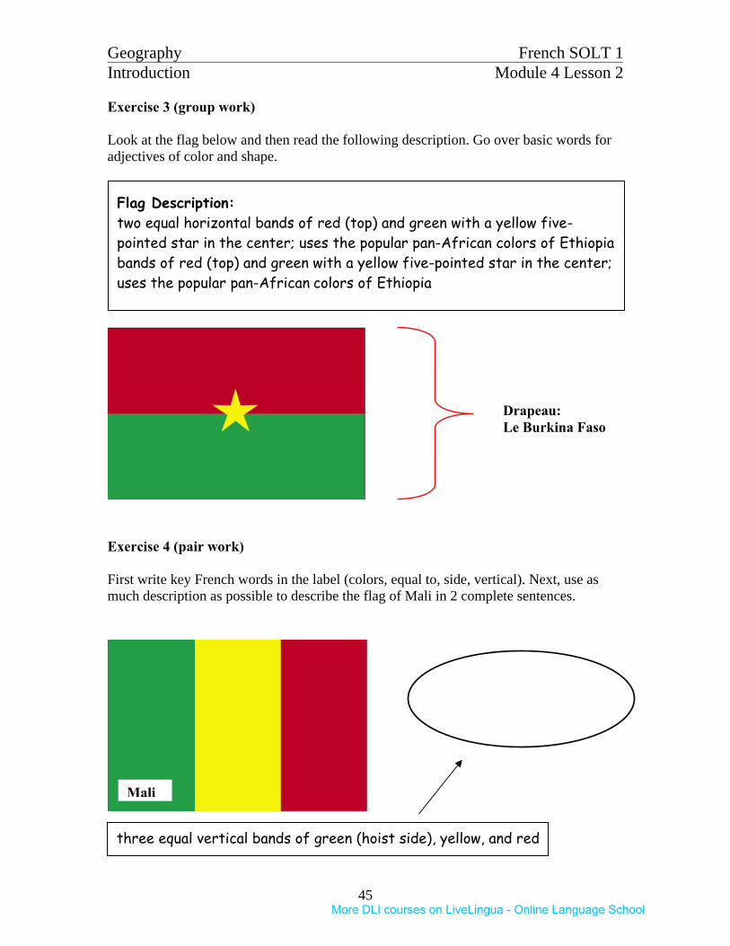
Exercise 3 (group work) Look at the flag below and then read the following description. Go over basic words for adjectives of color and shape.
Exercise 4 (pair work) First write key French words in the label (colors, equal to, side, vertical). Next, use as much description as possible to describe the flag of Mali in 2 complete sentences.
Flag Description: two equal horizontal bands of red (top) and green with a yellow five-pointed star in the center; uses the popular pan-African colors of Ethiopia bands of red (top) and green with a yellow five-pointed star in the center; uses the popular pan-African colors of Ethiopia
Drapeau: Le Burkina Faso
three equal vertical bands of green (hoist side), yellow, and red
Mali
More DLI courses on LiveLingua - Online Language School
Geography French SOLT 1Introduction Module 4 Lesson 2
46
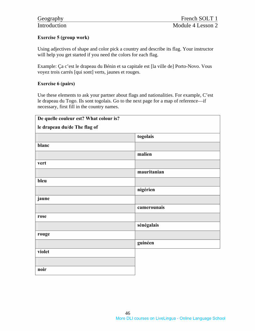
Exercise 5 (group work) Using adjectives of shape and color pick a country and describe its flag. Your instructor will help you get started if you need the colors for each flag. Example: Ça c’est le drapeau du Bénin et sa capitale est [la ville de] Porto-Novo. Vous voyez trois carrés [qui sont] verts, jaunes et rouges. Exercise 6 (pairs) Use these elements to ask your partner about flags and nationalities. For example, C’est le drapeau du Togo. Ils sont togolais. Go to the next page for a map of reference—if necessary, first fill in the country names. De quelle couleur est? What colour is?
le drapeau du/de The flag of
togolais
blanc
malien
vert
mauritanian
bleu
nigérien
jaune
camerounais
rose
sénégalais
rouge
guinéen
violet
noir
More DLI courses on LiveLingua - Online Language School
Geography French SOLT 1Introduction Module 4 Lesson 2
47 More DLI courses on LiveLingua - Online Language School
Geography French SOLT 1Introduction Module 4 Lesson 2
48
Briefing: how to give a brief in French Amadou is giving a brief about Senegal. Read his briefing and pay attention to certain words or expressions to use later. Le Sénégal est situé en Afrique de l’Ouest (ou Afrique occidentale). Il partage ses frontières avec la Mauritanie, la Guinée, la Guinée Bissau, le Mali et la Gambie qui est une enclave dans le pays. Le Sénégal est également limité à l’ouest par l’océan atlantique. La superficie est d’environ 196 190 km2, ce qui est un peu moins que la superficie du Dakota du Sud. Le climat est tropical, avec une saison pluvieuse (de juin à octobre) et une saison sèche (de novembre à mai) dominée par les vents d’harmattan (vent sec en provenance du Sahara). Le Sénégal est une démocratie et le président est élu tous les sept ans. Le Sénégal a un système parlementaire. Il y a au moins sept groupes ethniques dans le pays et chaque ethnie a sa propre langue et sa propre culture. La défense est assurée par l’armée de terre, l’armée de l’air, la gendarmerie, la marine et la police.
Located Borders Which is slightly less than Elected Its own language Navy
Exercise 7 (pairs) With your partner, answer the questions below according to the text above. 1. In which part of the continent is Senegal located?
2. Which ocean borders Senegal?
3. Which country is an enclave of Senegal?
4. Which US state is about the same size as Senegal?
5. What are the two main seasons in Senegal?
6. What kind of government does Senegal have?
7. How many ethnic groups are there in Senegal?
More DLI courses on LiveLingua - Online Language School
Geography French SOLT 1Introduction Module 4 Lesson 2
49
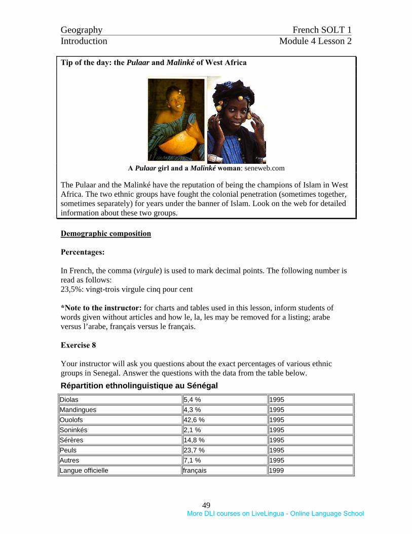
Tip of the day: the Pulaar and Malinké of West Africa
A Pulaar girl and a Malinké woman: seneweb.com
The Pulaar and the Malinké have the reputation of being the champions of Islam in West Africa. The two ethnic groups have fought the colonial penetration (sometimes together, sometimes separately) for years under the banner of Islam. Look on the web for detailed information about these two groups. Demographic composition Percentages: In French, the comma (virgule) is used to mark decimal points. The following number is read as follows: 23,5%: vingt-trois virgule cinq pour cent *Note to the instructor: for charts and tables used in this lesson, inform students of words given without articles and how le, la, les may be removed for a listing; arabe versus l’arabe, français versus le français. Exercise 8 Your instructor will ask you questions about the exact percentages of various ethnic groups in Senegal. Answer the questions with the data from the table below. Répartition ethnolinguistique au Sénégal Diolas 5,4 % 1995 Mandingues 4,3 % 1995 Ouolofs 42,6 % 1995 Soninkés 2,1 % 1995 Sérères 14,8 % 1995 Peuls 23,7 % 1995 Autres 7,1 % 1995 Langue officielle français 1999
More DLI courses on LiveLingua - Online Language School
Geography French SOLT 1Introduction Module 4 Lesson 2
50
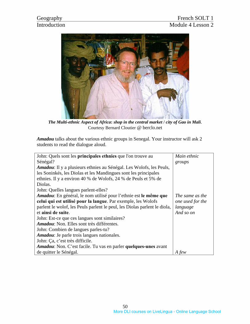
The Multi-ethnic Aspect of Africa: shop in the central market / city of Gao in Mali.
Courtesy Bernard Cloutier @ berclo.net Amadou talks about the various ethnic groups in Senegal. Your instructor will ask 2 students to read the dialogue aloud. John: Quels sont les principales ethnies que l'on trouve au Sénégal? Amadou: Il y a plusieurs ethnies au Sénégal. Les Wolofs, les Peuls, les Soninkés, les Diolas et les Mandingues sont les principales ethnies. Il y a environ 40 % de Wolofs, 24 % de Peuls et 5% de Diolas. John: Quelles langues parlent-elles? Amadou: En général, le nom utilisé pour l’ethnie est le même que celui qui est utilisé pour la langue. Par exemple, les Wolofs parlent le wolof, les Peuls parlent le peul, les Diolas parlent le diola, et ainsi de suite. John: Est-ce que ces langues sont similaires? Amadou: Non. Elles sont très différentes. John: Combien de langues parles-tu? Amadou: Je parle trois langues nationales. John: Ça, c’est très difficile. Amadou: Non. C’est facile. Tu vas en parler quelques-unes avant de quitter le Sénégal.
Main ethnic groups The same as the one used for the language And so on A few
More DLI courses on LiveLingua - Online Language School
Geography French SOLT 1Introduction Module 4 Lesson 2
51
Exercise 9 (group work) Answer the questions below according to the preceding dialogue. Move from the English to French answers. 1. What are the main ethnic groups in Senegal?
2. What is the language spoken by the Wolofs?
3. Do the different ethnic groups speak similar languages?
4. How many languages does Amadou speak?
More DLI courses on LiveLingua - Online Language School
Geography French SOLT 1Introduction Module 4 Lesson 2
52
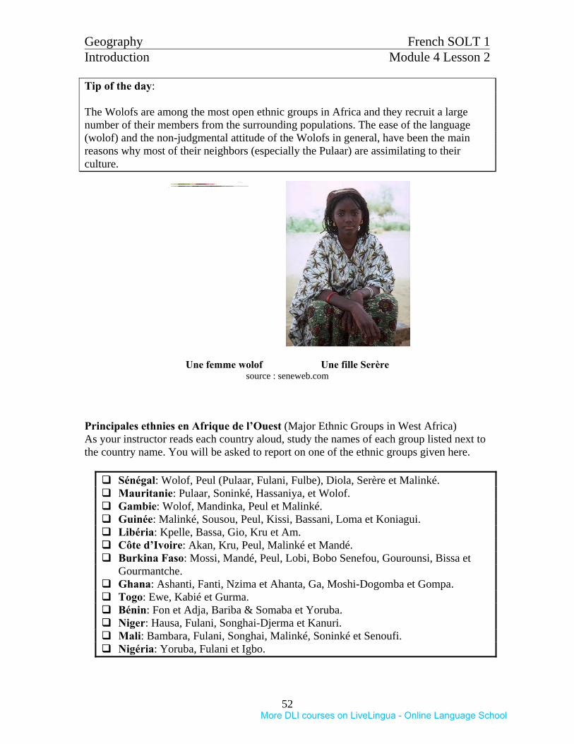
Tip of the day: The Wolofs are among the most open ethnic groups in Africa and they recruit a large number of their members from the surrounding populations. The ease of the language (wolof) and the non-judgmental attitude of the Wolofs in general, have been the main reasons why most of their neighbors (especially the Pulaar) are assimilating to their culture.
Principales ethnies en Afrique de l’Ouest (Major Ethnic Groups in West Africa) As your instructor reads each country aloud, study the names of each group listed next to the country name. You will be asked to report on one of the ethnic groups given here.
Sénégal: Wolof, Peul (Pulaar, Fulani, Fulbe), Diola, Serère et Malinké. Mauritanie: Pulaar, Soninké, Hassaniya, et Wolof. Gambie: Wolof, Mandinka, Peul et Malinké. Guinée: Malinké, Sousou, Peul, Kissi, Bassani, Loma et Koniagui. Libéria: Kpelle, Bassa, Gio, Kru et Am. Côte d’Ivoire: Akan, Kru, Peul, Malinké et Mandé. Burkina Faso: Mossi, Mandé, Peul, Lobi, Bobo Senefou, Gourounsi, Bissa et
Gourmantche. Ghana: Ashanti, Fanti, Nzima et Ahanta, Ga, Moshi-Dogomba et Gompa. Togo: Ewe, Kabié et Gurma. Bénin: Fon et Adja, Bariba & Somaba et Yoruba. Niger: Hausa, Fulani, Songhai-Djerma et Kanuri. Mali: Bambara, Fulani, Songhai, Malinké, Soninké et Senoufi. Nigéria: Yoruba, Fulani et Igbo.
Une femme wolof Une fille Serèresource : seneweb.com
More DLI courses on LiveLingua - Online Language School
Geography French SOLT 1Grammar Notes Module 4 Lesson 2
53
Relative pronouns qui and que (qu’)—who, whom, that, which Relative pronouns link 2 sentences or ideas: a relative clause (a clause that cannot stand alone) to a main clause. This prevents repetition and keeps the flow in written and oral speech. Relative pronouns in French can never be omitted, unlike in English. Relative pronouns include: qui, que, où, dont and lequel. Translation depends on context. The pronoun you use is determined by the grammatical function of the noun in the sentence in which it is replaced. • Qui is used to replace a noun (could be a person, an object…) that is the subject of the
relative clause. Qui does not always translate as “who”. The [i] on qui is not removed (see notes on que).
Examples:
1) Le Sénégal est un pays. Senegal is a country. 2) Ce pays est en Afrique de l’Ouest. This country is in West Africa.
→ Le Sénégal est un pays qui se trouve en Afrique de l’Ouest. Senegal is a country that is located in West Africa.
To link 2 sentences, identify the common noun (pays in the preceding example). In the second sentence, the word pays is the subject of the verb se trouver: therefore, you will use the relative pronoun qui to replace it. The relative pronoun comes right after the noun it replaces. • Que is used to replace a noun (a person, an object…) that is the direct object of the
relative clause. Que becomes qu’ in front of a vowel or mute h. Que is usually followed by a subject, then a verb.
Examples:
1) Le Sénégal est un pays. Senegal is a country. 2) Je voudrais visiter ce pays. I would like to visit this country.
→ Le Sénégal est un pays que je voudrais visiter. Senegal is a country that I would like to visit.
To link 2 sentences, identify the common noun (pays in the preceding example). In the second sentence, the word pays is the object of the verb visiter: therefore, you will use the relative pronoun que to replace it. The relative pronoun comes right after the noun it replaces.
More DLI courses on LiveLingua - Online Language School
Geography French SOLT 1Grammar Notes Module 4 Lesson 2
54
Exercise 1 As a class, discuss the differences in these 2 sentences and how it shapes meaning.
1) Voilà le guide que cherchent les touristes. 2) Voilà le guide qui cherche les touristes.
Exercise 2 Link the following sentences with a relative pronoun. Keep the first sentence as your main clause; the second one will be your relative clause. 1. J’écris à mes parents. Mes parents habitent au Mali.
J’écris à mes parents qui habitent au Mali.
2. Tu lis un livre. Karim t’a donné ce livre.
Tu lis un livre que Karim t’a donné.
3. Elle attend l’avion. L’avion est en provenance de Ouagadougou.
Elle attend l’avion qui est en provenance de Ouagadougou.
4. Ils attendent l’arrivée du général. Le général commande l’armée de terre.
Ils attendent l’arrivée du général qui commande l’armée de terre.
5. Le train va à Dakar. Tu prends le train.
Le train que tu prends va à Dakar.
Exercise 3 Read the following paragraph about Mali and then fill in the blanks with a relative pronoun. Go over your answers with the class.
Le Mali est un pays qui se situe à l’Est du Sénégal. Bamako, sa capitale, est une
ville que j’aime beaucoup. Le Mali, qui est un des plus grands pays d’Afrique, n’a pas de
débouché maritime. Le fleuve Niger, que beaucoup connaissent en Afrique, est la source
d’eau principale du pays. Le Mali, a un climat qui est chaud et sec et des sites historiques
que beaucoup de gens aiment. Le pays, qui est très pauvre, est bien connu dans le monde.
More DLI courses on LiveLingua - Online Language School
Geography French SOLT 1Grammar Notes Module 4 Lesson 2
55
The relative pronoun qui with prepositions Qui can be preceded by a preposition such as à, chez, avec, or pour. Whereas in English the preposition goes at the end of the relative clause, in French it comes between the noun and the relative pronoun. Example: Mariama est une amie. Je fais du ski avec Mariama. Mariama is a friend. I ski with Mariama Mariama est une amie avec qui je fais du ski. Mariama is a friend I ski with Exercise 4 Link the following sentences with a relative pronoun + preposition. 1. Mes parents sont au Cameroun. Je téléphone à mes parents une fois par mois.
Mes parents, à qui je téléphone une fois par mois, sont au Cameroun.
2. Julie est ma voisine. Je joue au tennis avec Julie.
Julie, avec qui je joue au tennis, est ma voisine.
3. Abdou est mon meilleur ami. Je vais chez Abdou tous les week-ends.
Abdou, chez qui je vais tous les week-ends, est mon meilleur ami.
4. M. Dieng est très sympathique. Je travaille pour M. Dieng.
M. Dieng, pour qui je travaille, est très sympathique.
Exercise 5 (pairs) Use qui and rearrange different words to make new sentences with the information from Exercise 4. For example, Je travaille pour Monsieur Dieng qui est très sympa.
Sample Answers: Je vais chez Abdou qui est mon meilleur ami. Je téléphone à mes parents qui sont au Cameroun.
More DLI courses on LiveLingua - Online Language School
Geography French SOLT 1Vocabulary Module 4 Lesson 2
56
Âme (n.f) Arrivée (n.f) Capitale (n.f) Climat (n.m) Confirmer (verb) Connaître (verb) (Se connaître) Croître (verb) Débouché maritime (n.m) Déséquilibre (n.m) Disparité (n.f) Effectif (n.m) Élire (verb) En provenance Estimer (verb) Ethnie (n.f) Frontière (n.f) Gens (n.m.pl.) Habitant (e) noun Histoire (n.f) Langue (n.f) Nationalité (n.f) Océan Atlantique (n.m) Partager (verb) Pauvre (adj.) P.I.B. (n.m) Produit Intérieur Brut Population (n.f) Processus (n.m) Répartition (n.f) Saison pluvieuse (n.f) Se situer (verb) Se trouver (verb) Superficie (n.f) Surpeuplement (n.m) Territoire (n.m) Vent (n.m)
Soul Arrival Capital city Climate To confirm, reinforce To know someone, something, to meet, to master, to be acquainted with To grow Maritime outlet Imbalance Disparity Strength, size (number) To Elect From, Coming from To estimate Ethnic group Border People Inhabitant Story, saga, account, tale, history Language, Tongue Nationality, Citizenship Atlantic Ocean To share Poor Gross Domestic Product Population Process Restitution, mending, redress, repartition Rainy season To be situated To be located (Surface) Area Overpopulation Territory Wind
More DLI courses on LiveLingua - Online Language School
Geography French SOLT 1Culture Notes Module 4 Lesson 2
57
Location of military installations in West Africa
Because of real or imagined internal and external political insecurity, most African nations have engaged in a military race to extend their might to weaker neighbors or to defend themselves against possible attacks. This, in return, has fostered a culture of militarism, which, in many instances, has served to stall the political process in these countries or to put an end to some of the most promising democracies on the continent.
Even though the size of these armies is small in terms of headcounts, some
African countries, like Mauritania, have some of the highest ratio of military personnel to civilians in the world. The main reason for this phenomenon is that in the African context, the role of the army as a defender of a country’s territorial integrity has unfortunately been dramatically altered. Armies are now trained to protect reigning dictatorships and to crush any internal political or military opposition. It is, therefore, not surprising that with the exception of border regions, the bulk of the military camps and bases in African countries are located in “troubled” administrative regions where their presence serves as an intimidation device. For the first 25 years of the country’s independence, for instance, Southern Mauritania had been free of any military presence. However, with the coming to power of the current president, the region has been literally under military siege. Military camps and bases have sprouted everywhere in the South because southern Mauritanians are viewed as opposed to the government.
The new unofficial mission of the army has resulted in the strengthening of the
traditional “Garde présidentielle” (Presidential Guards: soldiers trained specifically for the security of the president), which, in many countries, has become a better-equipped, ethnically based army within the regular army. Because of the frequency of military coups and their mistrust of the army in general, many African presidents recruit members of the “Garde présidentielle” from their own ethnic groups or geographical regions to ensure loyalty. In Guinea, for instance, there is a real social unease as Sousou (the president’s ethnic group) young men are seen, many times a week, receiving military- type training in the capital’s streets. The general population alleges that the country’s president is organizing a militia from his own ethnic group to protect him against coup attempts.
Ethnic repartition and politics in Africa
One of the negative and enduring legacies of the colonial presence in Africa is the ethnic repartition that took place after African countries were divided into European zones of influence at the Berlin summit of 1884. Unmindful of the local realities and simply motivated by economic gain and political control over the region, the European colonizers partitioned the continent through their “divide and rule” philosophy. The express intention was to weaken the traditional sources of power in order to prevent them from posing a potential threat to European presence in that part of the world. Thus, many once united and unified linguistic and ethnic entities were purposefully separated to achieve the intended goal. Beyond the human tragedy of breaking family ties and traditional social and cultural structures, the repartition of Africa into French, British,
More DLI courses on LiveLingua - Online Language School
Geography French SOLT 1Culture Notes Module 4 Lesson 2
58
Portuguese or Spanish colonies has created different mindsets and organizational values. Indeed, each colonial power had unique political and economic agendas and indoctrination schemes. In independent Africa, these different agendas and schemes have caused such stumbling blocks that few unification attempts have been tried throughout the continent.
Thus, the confederation between Senegal and the Gambia, sketched out in the mid-1970s, failed miserably because of incompatible legislative and economic philosophies inherited respectively from France and Britain. Yet, the two countries share common ethno-linguistic backgrounds, and the Gambia is, geographically, almost a Senegalese enclave. Instances of this kind of philosophical incompatibility resulting from the colonial action abound and have been noticed even at the continental level to explain the Organization of African Unity’s (OAU) inefficiency. General opinion is that within this continental organization, countries with the same colonial history tend to cluster together to try and impose their views. Colonial legacy has therefore superseded ethno-linguistic commonality in many cases.
Even in situations where the parties involved share similar ethno-linguistic
backgrounds and colonial history, as was the case in the early 1960s between Mali and Senegal, the failure to unify has been blamed on the former colonizers. European colonial powers are still viewed as exerting strong influence behind the scene to prevent the emergence of unified and stronger states in Africa. The argument is that the former colonizers fear that they would have less influence with a unified Africa than with one made up of small and autonomous states.
It is at the national level that the dynamics of ethno-linguistic repartition takes on
a particular importance. Indeed, ethnic and/or linguistic affiliations have been deliberately and skillfully manipulated, not only by the colonial powers, but also by leaders of independent Africa. In Central Africa, for example, the French divided the Tutsi and the Hutu who, in every respect, constitute one people, into two major ethnic groups. The Tutsi form the overwhelming majority in Burundi and the Hutu the overwhelming majority in Rwanda. This intentional partitioning has become the source of an ongoing ethnic unrest in the region. Whenever one minority feels oppressed in one country, their co-ethnics organize a reprisal in the other. Hence the genocide that took place in both countries as recently as the mid-1990s.
Central Africa is not the only area where ethnic division was deliberately
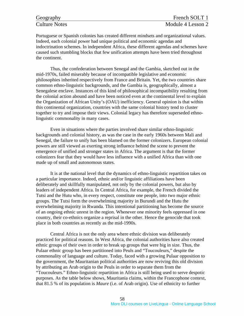
practiced for political reasons. In West Africa, the colonial authorities have also created ethnic groups of their own in order to break up groups that were big in size. Thus, the Pulaar ethnic group has been partitioned into Peuls and “Toucouleurs,” despite the commonality of language and culture. Today, faced with a growing Pulaar opposition to the government, the Mauritanian political authorities are now reviving this old division by attributing an Arab origin to the Peuls in order to separate them from the “Toucouleurs.” Ethno-linguistic repartition in Africa is still being used to serve despotic purposes. As the table below shows, Mauritania claims, within the Francophone context, that 81.5 % of its population is Maure (i.e. of Arab origin). Use of ethnicity to further
More DLI courses on LiveLingua - Online Language School
Geography French SOLT 1Culture Notes Module 4 Lesson 2
59
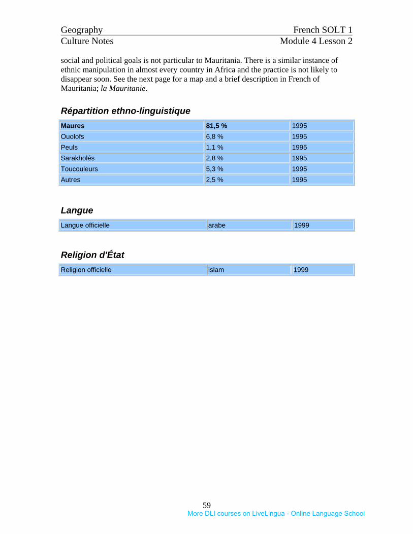
social and political goals is not particular to Mauritania. There is a similar instance of ethnic manipulation in almost every country in Africa and the practice is not likely to disappear soon. See the next page for a map and a brief description in French of Mauritania; la Mauritanie.
Répartition ethno-linguistique
Langue
Religion d'État
Maures 81,5 % 1995 Ouolofs 6,8 % 1995 Peuls 1,1 % 1995 Sarakholés 2,8 % 1995 Toucouleurs 5,3 % 1995 Autres 2,5 % 1995
Langue officielle arabe 1999
Religion officielle islam 1999
More DLI courses on LiveLingua - Online Language School
Geography French SOLT 1Culture Notes Module 4 Lesson 2
60
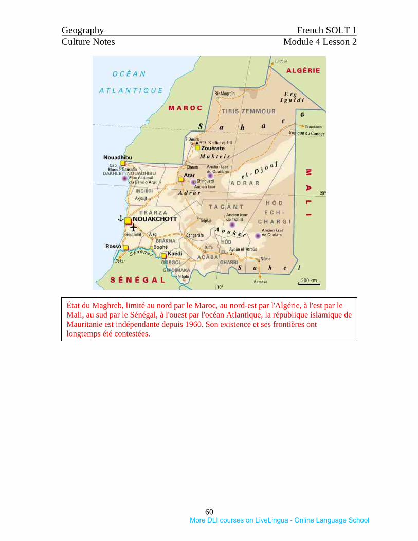
État du Maghreb, limité au nord par le Maroc, au nord-est par l'Algérie, à l'est par le Mali, au sud par le Sénégal, à l'ouest par l'océan Atlantique, la république islamique de Mauritanie est indépendante depuis 1960. Son existence et ses frontières ont longtemps été contestées.
More DLI courses on LiveLingua - Online Language School
Geography French SOLT 1Application Activities Module 4 Lesson 2
61
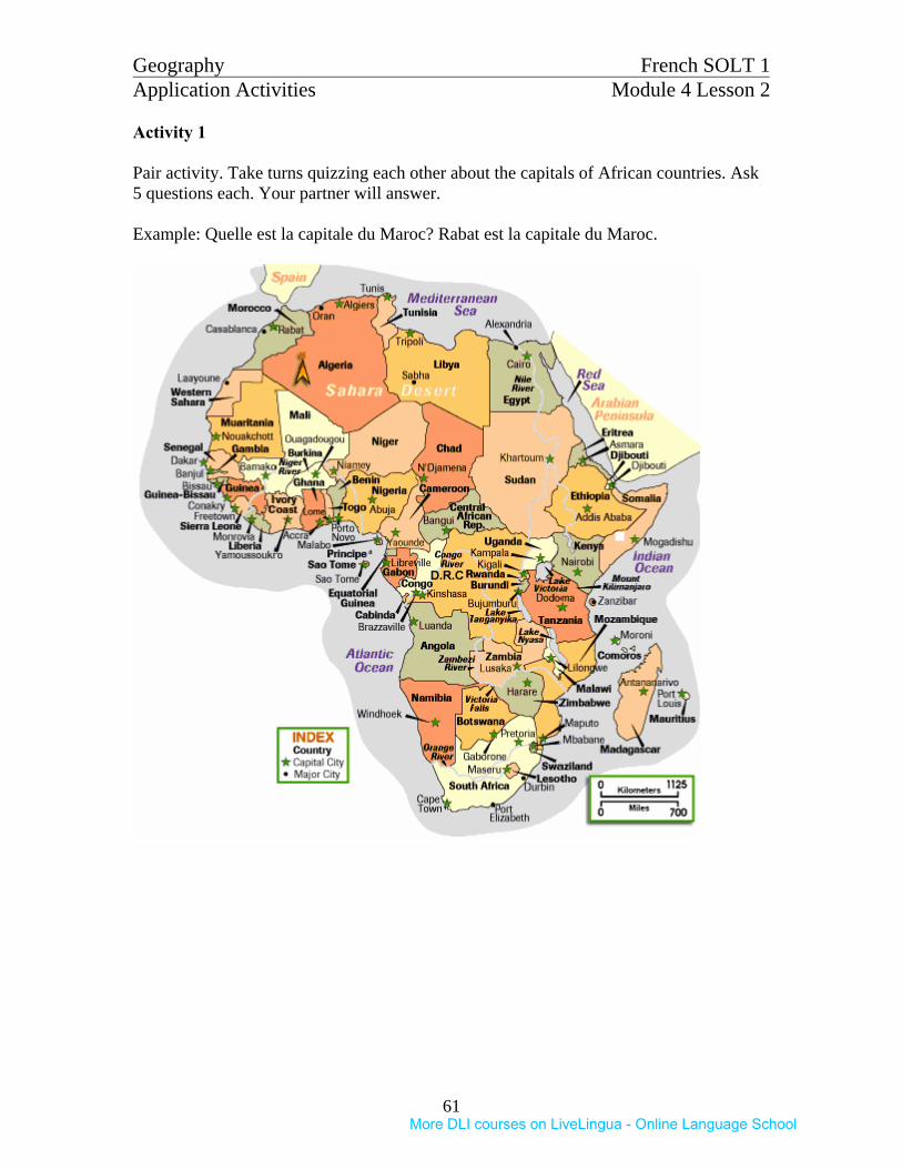
Activity 1 Pair activity. Take turns quizzing each other about the capitals of African countries. Ask 5 questions each. Your partner will answer. Example: Quelle est la capitale du Maroc? Rabat est la capitale du Maroc.
More DLI courses on LiveLingua - Online Language School
Geography French SOLT 1Application Activities Module 4 Lesson 2
62
Activity 2 Your instructor will read about different African countries. Listen while looking at the map from the previous activity and identify which countries are being referred to. Script: 1. Ce petit pays francophone de l’Afrique centrale se situe au sud de l’Ouganda. Il y a eu un génocide entre les Tutsis et les Hutus qui a fait la une des journaux en 1995. Le Rwanda 2. Ce pays anglophone est en Afrique occidentale. Il est entouré de pays francophones: le Bénin, le Niger, le Tchad et le Cameroun. Sa capitale est Lagos. Le Nigeria 3. C’est le plus grand pays d’Afrique du Nord. Il se trouve entre le Maroc et la Tunisie. On y parle le français et l’arabe. L’Algérie
More DLI courses on LiveLingua - Online Language School
Geography French SOLT 1Application Activities Module 4 Lesson 2
63
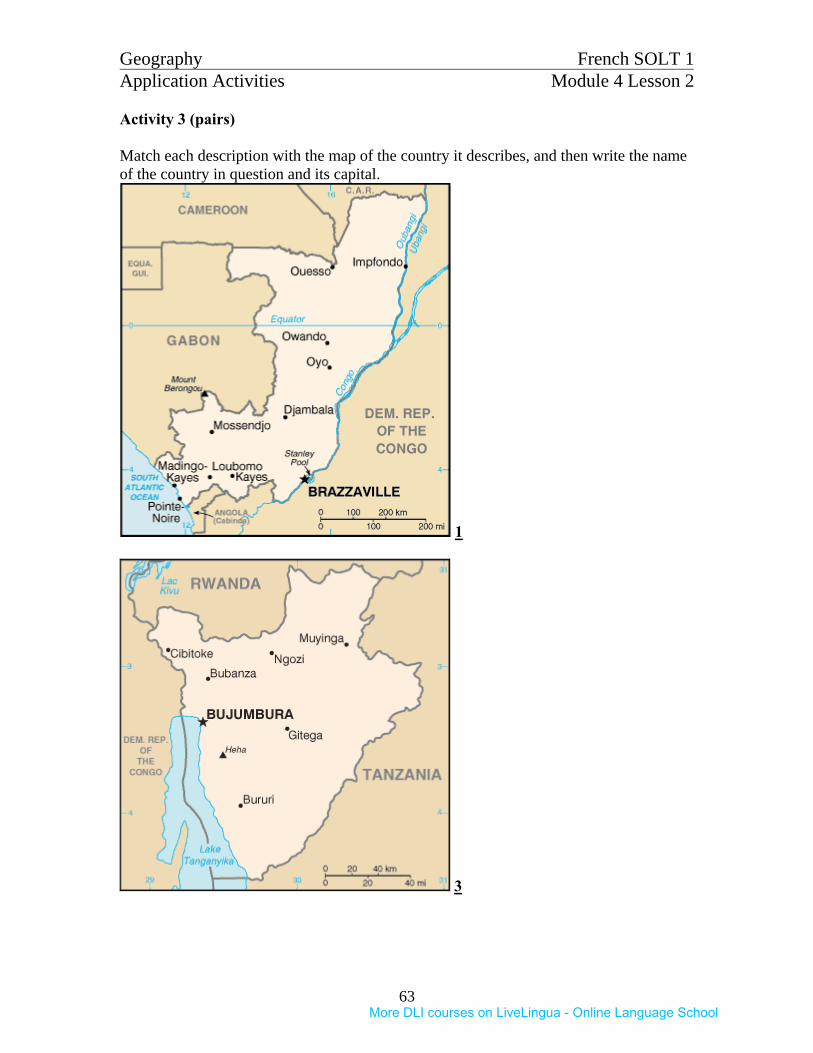
Activity 3 (pairs) Match each description with the map of the country it describes, and then write the name of the country in question and its capital.
1
3
More DLI courses on LiveLingua - Online Language School
Geography French SOLT 1Application Activities Module 4 Lesson 2
64
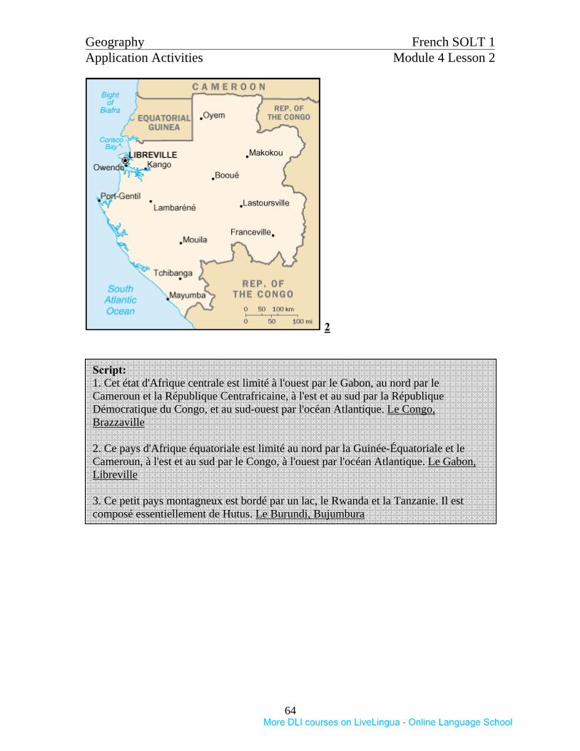
2
Script: 1. Cet état d'Afrique centrale est limité à l'ouest par le Gabon, au nord par le Cameroun et la République Centrafricaine, à l'est et au sud par la République Démocratique du Congo, et au sud-ouest par l'océan Atlantique. Le Congo, Brazzaville 2. Ce pays d'Afrique équatoriale est limité au nord par la Guinée-Équatoriale et le Cameroun, à l'est et au sud par le Congo, à l'ouest par l'océan Atlantique. Le Gabon, Libreville 3. Ce petit pays montagneux est bordé par un lac, le Rwanda et la Tanzanie. Il est composé essentiellement de Hutus. Le Burundi, Bujumbura
More DLI courses on LiveLingua - Online Language School
Geography French SOLT 1Application Activities Module 4 Lesson 2
65
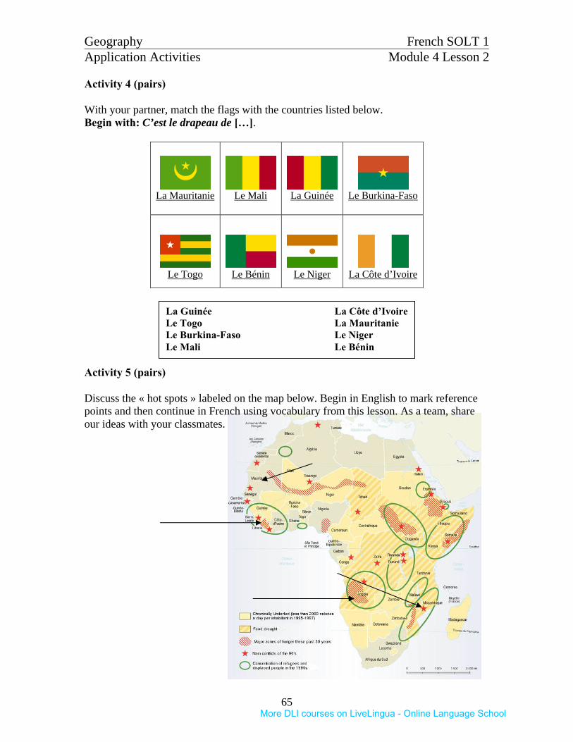
Activity 4 (pairs) With your partner, match the flags with the countries listed below. Begin with: C’est le drapeau de […].
La Mauritanie
Le Mali
La Guinée
Le Burkina-Faso
Le Togo
Le Bénin
Le Niger
La Côte d’Ivoire
Activity 5 (pairs) Discuss the « hot spots » labeled on the map below. Begin in English to mark reference points and then continue in French using vocabulary from this lesson. As a team, share our ideas with your classmates.
La Guinée La Côte d’Ivoire Le Togo La Mauritanie Le Burkina-Faso Le Niger Le Mali Le Bénin
More DLI courses on LiveLingua - Online Language School
Geography French SOLT 1Skill Enhancement Activities Module 4 Lesson 2
66
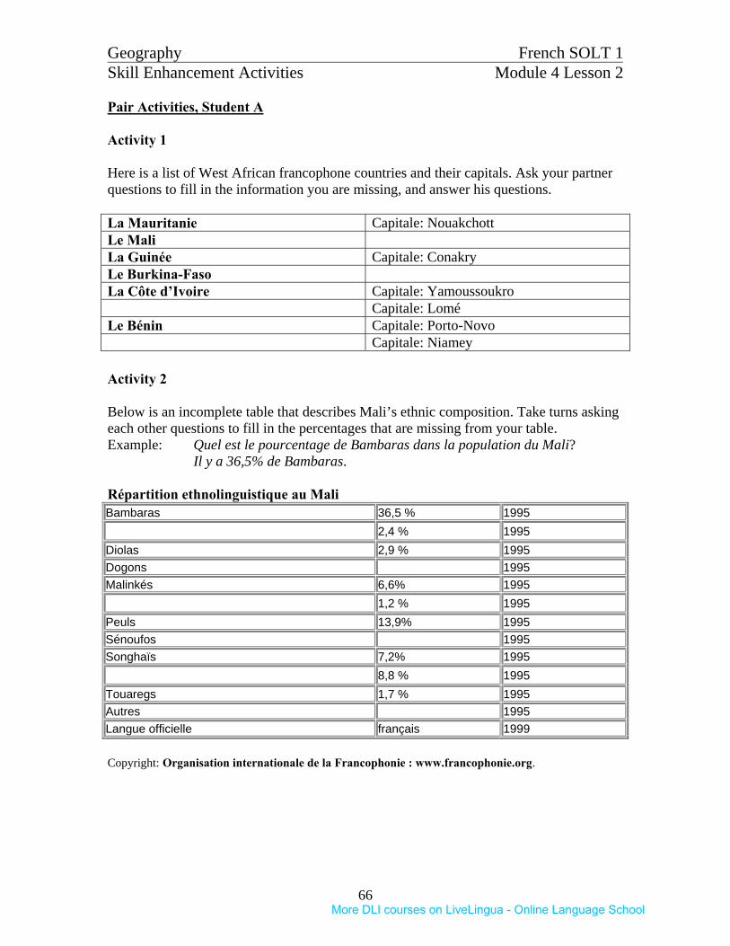
Pair Activities, Student A Activity 1 Here is a list of West African francophone countries and their capitals. Ask your partner questions to fill in the information you are missing, and answer his questions. La Mauritanie Capitale: Nouakchott Le Mali La Guinée Capitale: Conakry Le Burkina-Faso La Côte d’Ivoire Capitale: Yamoussoukro Capitale: Lomé Le Bénin Capitale: Porto-Novo Capitale: Niamey Activity 2 Below is an incomplete table that describes Mali’s ethnic composition. Take turns asking each other questions to fill in the percentages that are missing from your table. Example: Quel est le pourcentage de Bambaras dans la population du Mali? Il y a 36,5% de Bambaras. Répartition ethnolinguistique au Mali Bambaras 36,5 % 1995 2,4 % 1995 Diolas 2,9 % 1995 Dogons 1995 Malinkés 6,6% 1995 1,2 % 1995 Peuls 13,9% 1995 Sénoufos 1995 Songhaïs 7,2% 1995 8,8 % 1995 Touaregs 1,7 % 1995 Autres 1995 Langue officielle français 1999 Copyright: Organisation internationale de la Francophonie : www.francophonie.org.
More DLI courses on LiveLingua - Online Language School
Geography French SOLT 1Skill Enhancement Activities Module 4 Lesson 2
67
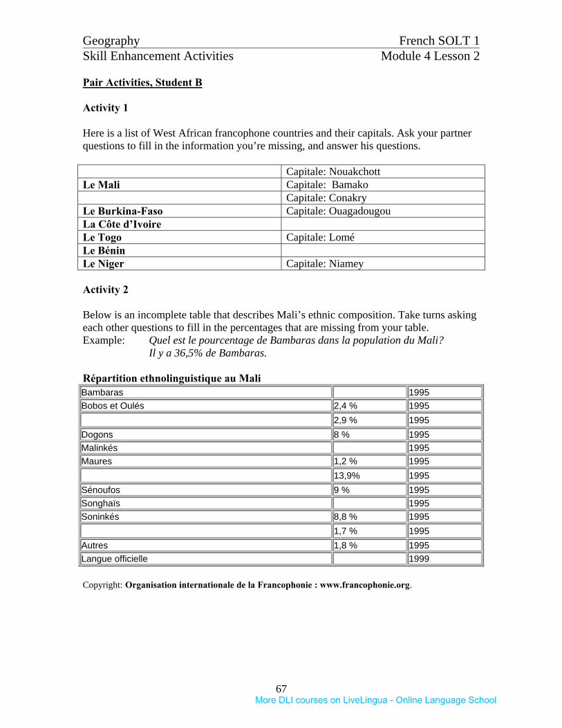
Pair Activities, Student B Activity 1 Here is a list of West African francophone countries and their capitals. Ask your partner questions to fill in the information you’re missing, and answer his questions. Capitale: Nouakchott Le Mali Capitale: Bamako Capitale: Conakry Le Burkina-Faso Capitale: Ouagadougou La Côte d’Ivoire Le Togo Capitale: Lomé Le Bénin Le Niger Capitale: Niamey Activity 2 Below is an incomplete table that describes Mali’s ethnic composition. Take turns asking each other questions to fill in the percentages that are missing from your table. Example: Quel est le pourcentage de Bambaras dans la population du Mali? Il y a 36,5% de Bambaras. Répartition ethnolinguistique au Mali Bambaras 1995 Bobos et Oulés 2,4 % 1995 2,9 % 1995 Dogons 8 % 1995 Malinkés 1995 Maures 1,2 % 1995 13,9% 1995 Sénoufos 9 % 1995 Songhaïs 1995 Soninkés 8,8 % 1995 1,7 % 1995 Autres 1,8 % 1995 Langue officielle 1999 Copyright: Organisation internationale de la Francophonie : www.francophonie.org.
More DLI courses on LiveLingua - Online Language School
Geography French SOLT 1Skill Enhancement Activities Module 4 Lesson 2
68
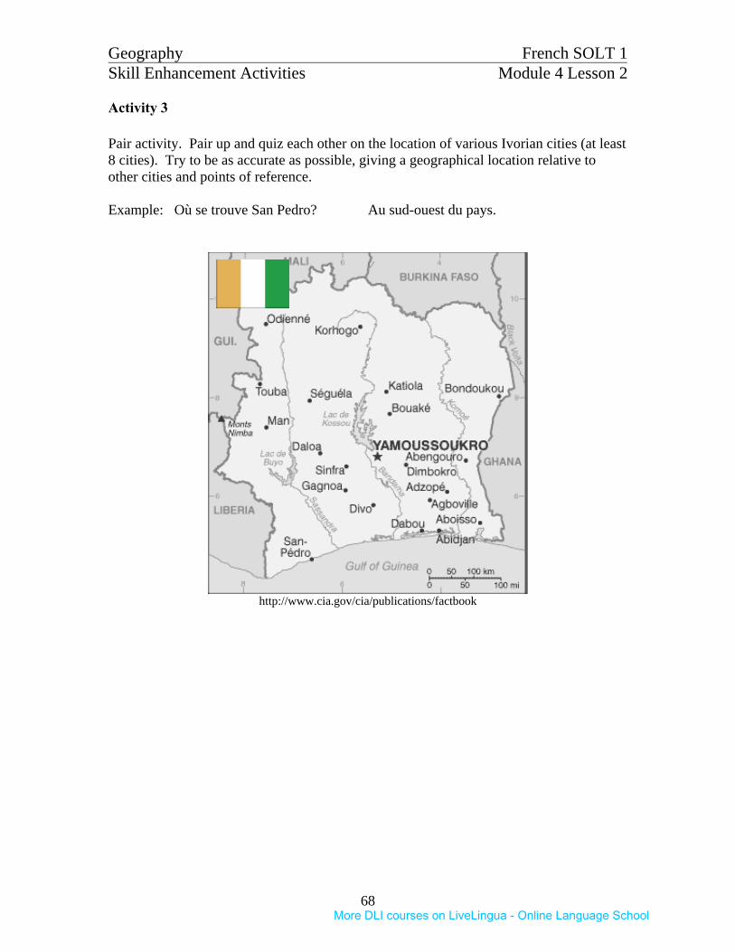
Activity 3 Pair activity. Pair up and quiz each other on the location of various Ivorian cities (at least 8 cities). Try to be as accurate as possible, giving a geographical location relative to other cities and points of reference. Example: Où se trouve San Pedro? Au sud-ouest du pays.
http://www.cia.gov/cia/publications/factbook
More DLI courses on LiveLingua - Online Language School
Geography French SOLT 1Skill Enhancement Activities Module 4 Lesson 2
69
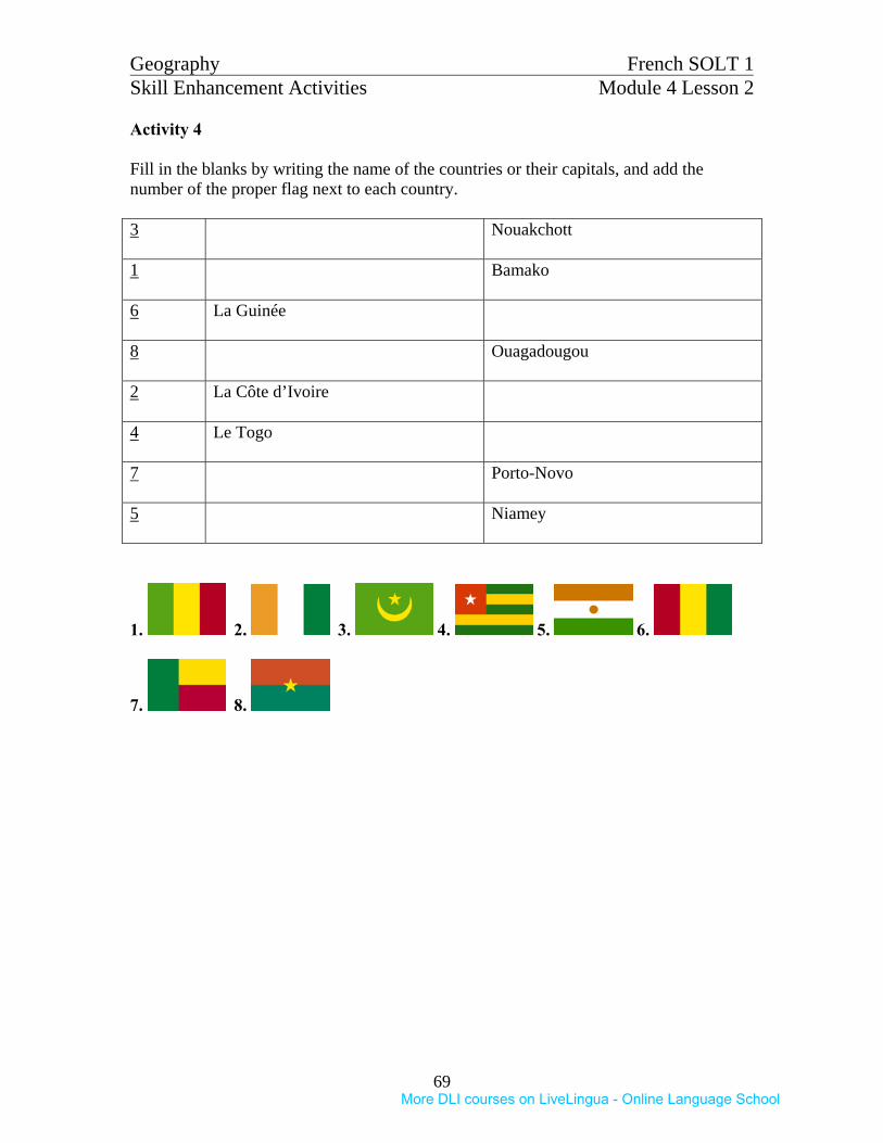
Activity 4 Fill in the blanks by writing the name of the countries or their capitals, and add the number of the proper flag next to each country. 3
Nouakchott
1
Bamako
6 La Guinée
8
Ouagadougou
2 La Côte d’Ivoire
4 Le Togo
7
Porto-Novo
5
Niamey
1. 2. 3. 4. 5. 6.
7. 8.
More DLI courses on LiveLingua - Online Language School
Geography French SOLT 1Homework Module 4 Lesson 2
70
Activity 1 You are asked to give a briefing to Senegalese soldiers about the United States. Write a paragraph about your country. Remember to use relative pronouns whenever possible to keep the flow. Aux États-Unis, En Amérique, Dans mon pays, Activity 2 Be prepared to give a briefing to your team about a West African country of your choice. *Note to the instructor: Before assigning this homework exercise, delegate one student to “lead” the group for country selections. This way, each student will study and present a different Francophone area.
More DLI courses on LiveLingua - Online Language School
Geography French SOLT 1Homework Module 4 Lesson 2
71
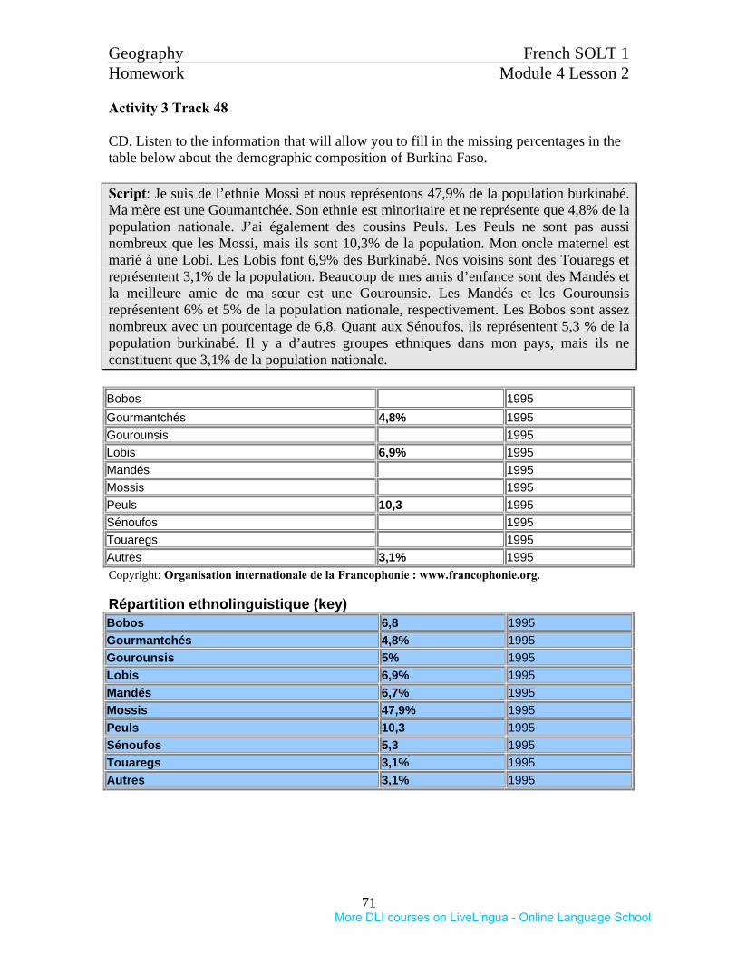
Activity 3 Track 48 CD. Listen to the information that will allow you to fill in the missing percentages in the table below about the demographic composition of Burkina Faso. Script: Je suis de l’ethnie Mossi et nous représentons 47,9% de la population burkinabé. Ma mère est une Goumantchée. Son ethnie est minoritaire et ne représente que 4,8% de la population nationale. J’ai également des cousins Peuls. Les Peuls ne sont pas aussi nombreux que les Mossi, mais ils sont 10,3% de la population. Mon oncle maternel est marié à une Lobi. Les Lobis font 6,9% des Burkinabé. Nos voisins sont des Touaregs et représentent 3,1% de la population. Beaucoup de mes amis d’enfance sont des Mandés et la meilleure amie de ma sœur est une Gourounsie. Les Mandés et les Gourounsis représentent 6% et 5% de la population nationale, respectivement. Les Bobos sont assez nombreux avec un pourcentage de 6,8. Quant aux Sénoufos, ils représentent 5,3 % de la population burkinabé. Il y a d’autres groupes ethniques dans mon pays, mais ils ne constituent que 3,1% de la population nationale. Bobos 1995 Gourmantchés 4,8% 1995 Gourounsis 1995 Lobis 6,9% 1995 Mandés 1995 Mossis 1995 Peuls 10,3 1995 Sénoufos 1995 Touaregs 1995 Autres 3,1% 1995 Copyright: Organisation internationale de la Francophonie : www.francophonie.org. Répartition ethnolinguistique (key) Bobos 6,8 1995 Gourmantchés 4,8% 1995 Gourounsis 5% 1995 Lobis 6,9% 1995 Mandés 6,7% 1995 Mossis 47,9% 1995 Peuls 10,3 1995 Sénoufos 5,3 1995 Touaregs 3,1% 1995 Autres 3,1% 1995
More DLI courses on LiveLingua - Online Language School
Geography French SOLT 1Homework Module 4 Lesson 2
72
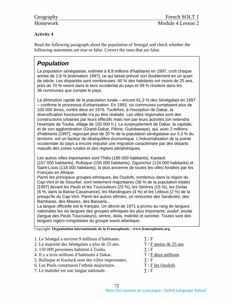
Activity 4 Read the following paragraph about the population of Senegal and check whether the following statements are true or false. Correct the ones that are false.
Copyright: Organisation internationale de la Francophonie : www.francophonie.org. 1. Le Sénégal a environ 9 millions d’habitants. T / F 2. La majorité des Sénégalais a plus de 25 ans. T / F moins de 25 ans 3. 150 000 personnes habitent à Touba. T / F 4. Il y a trois millions d’habitants à Dakar. T / F deux millions 5. Rufisque et Kaolack sont des villes importantes. T / F 6. Les Peuls constituent l’ethnie majoritaire. T / F les Ouolofs 7. Le malinké est une langue nationale. T / F
Population La population sénégalaise, estimée à 8,8 millions d'habitants en 1997, croît chaque année de 2,8 % [estimation 1997], ce qui laisse prévoir son doublement en un quart de siècle. Les disparités sont nombreuses: 60 % des habitants ont moins de 25 ans, près de 70 % vivent dans le tiers occidental du pays et 39 % résident dans les 36 communes que compte le pays. La diminution rapide de la population rurale – encore 61,3 % des Sénégalais en 1997 – confirme le processus d'urbanisation. En 1993, six communes comptaient plus de 100 000 âmes, contre deux en 1976. Toufefois, à l'exception de Dakar, la diversification fonctionnelle n'a pu être réalisée. Les villes régionales sont des constructions urbaines par leurs effectifs mais non par leurs activités (on retiendra l'exemple de Touba, village de 150 000 h.). Le surpeuplement de Dakar, la capitale, et de son agglomération (Grand-Dakar, Pikine, Guédiawaye), qui, avec 2 millions d'habitants [1997], regroupe plus de 20 % de la population sénégalaise sur 0,3 % du territoire, est un facteur de déséquilibre économique. L'industrialisation de la pointe occidentale du pays a encore impulsé une migration caractérisée par des départs massifs des zones rurales et des régions périphériques. Les autres villes importantes sont Thiès (185 000 habitants), Kaolack (157 000 habitants), Rufisque (150 000 habitants), Ziguinchor (124 000 habitants) et Saint-Louis (118 000 habitants), la plus ancienne de toutes les villes fondées par les Français en Afrique. Parmi les principaux groupes ethniques, les Ouolofs, nombreux dans la région du Cap-Vert et de Diourbel, sont nettement majoritaires (36 % de la population totale) [1997] devant les Peuls et les Toucouleurs (23 %), les Sérères (15 %), les Diolas (6 %, dans la Basse-Casamance), les Mandingues (4 %) et les Lébous (2 %) de la presqu'île du Cap-Vert. Parmi les autres ethnies, on rencontre des Sarakolés, des Bambaras, des Maures, des Bassaris... La langue officielle est le français. Un décret de 1971 a promu au rang de langues nationales les six langues des groupes ethniques les plus importants: ouolof, poular (langue des Peuls Toucouleurs), sérère, diola, malinké et soninké. Toutes sont des langues nigéro-congolaises du groupe ouest-atlantique.
More DLI courses on LiveLingua - Online Language School
Geography French SOLT 1Homework Module 4 Lesson 2
73
A Pulaar family in the Senegal Valley: Courtesy Bernard Cloutier @ berclo.net
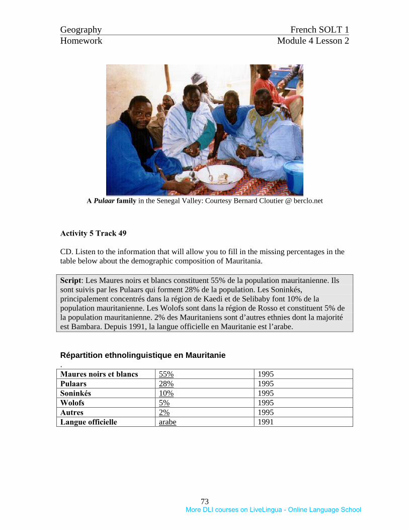
Activity 5 Track 49 CD. Listen to the information that will allow you to fill in the missing percentages in the table below about the demographic composition of Mauritania. Script: Les Maures noirs et blancs constituent 55% de la population mauritanienne. Ils sont suivis par les Pulaars qui forment 28% de la population. Les Soninkés, principalement concentrés dans la région de Kaedi et de Selibaby font 10% de la population mauritanienne. Les Wolofs sont dans la région de Rosso et constituent 5% de la population mauritanienne. 2% des Mauritaniens sont d’autres ethnies dont la majorité est Bambara. Depuis 1991, la langue officielle en Mauritanie est l’arabe. Répartition ethnolinguistique en Mauritanie . Maures noirs et blancs 55% 1995 Pulaars 28% 1995 Soninkés 10% 1995 Wolofs 5% 1995 Autres 2% 1995 Langue officielle arabe 1991
More DLI courses on LiveLingua - Online Language School
Geography French SOLT 1Homework Module 4 Lesson 2
74
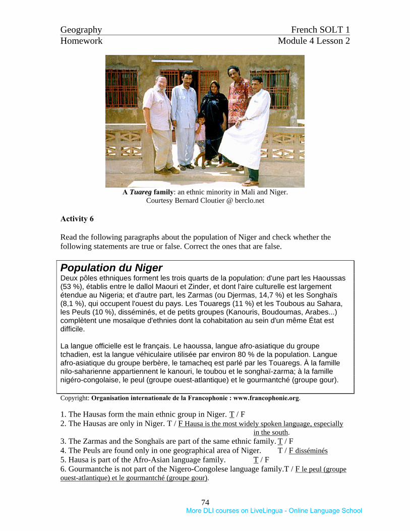
A Tuareg family: an ethnic minority in Mali and Niger.
Courtesy Bernard Cloutier @ berclo.net Activity 6 Read the following paragraphs about the population of Niger and check whether the following statements are true or false. Correct the ones that are false.
Population du Niger Deux pôles ethniques forment les trois quarts de la population: d'une part les Haoussas (53 %), établis entre le dallol Maouri et Zinder, et dont l'aire culturelle est largement étendue au Nigeria; et d'autre part, les Zarmas (ou Djermas, 14,7 %) et les Songhaïs (8,1 %), qui occupent l'ouest du pays. Les Touaregs (11 %) et les Toubous au Sahara, les Peuls (10 %), disséminés, et de petits groupes (Kanouris, Boudoumas, Arabes...) complètent une mosaïque d'ethnies dont la cohabitation au sein d'un même État est difficile. La langue officielle est le français. Le haoussa, langue afro-asiatique du groupe tchadien, est la langue véhiculaire utilisée par environ 80 % de la population. Langue afro-asiatique du groupe berbère, le tamacheq est parlé par les Touaregs. À la famille nilo-saharienne appartiennent le kanouri, le toubou et le songhaï-zarma; à la famille nigéro-congolaise, le peul (groupe ouest-atlantique) et le gourmantché (groupe gour). Copyright: Organisation internationale de la Francophonie : www.francophonie.org. 1. The Hausas form the main ethnic group in Niger. T / F 2. The Hausas are only in Niger. T / F Hausa is the most widely spoken language, especially
in the south. 3. The Zarmas and the Songhaïs are part of the same ethnic family. T / F 4. The Peuls are found only in one geographical area of Niger. T / F disséminés 5. Hausa is part of the Afro-Asian language family. T / F 6. Gourmantche is not part of the Nigero-Congolese language family.T / F le peul (groupe ouest-atlantique) et le gourmantché (groupe gour).
More DLI courses on LiveLingua - Online Language School
Geography French SOLT 1Homework Module 4 Lesson 2
75
Activity 7 Below are some very important dates related to la Francophonie. Do outside research if necessary to find a match for each date listed here.
1999
Septième Sommet francophone à Hanoi, du 14 au 16 novembre.
Création du Secrétariat général. Election de Boutros Boutros-Ghali au poste de Secrétaire général.
1998 La Conférence ministérielle de Bucarest adopte l'appellation d' « Organisation Internationale de la Francophonie ».
1997 Huitième Sommet francophone à Moncton, du 3 au 5 septembre, sur le thème de la jeunesse.
2004 Neuvième Sommet francophone à Beyrouth, du 18 au 20 octobre, sur le thème du dialogue des cultures.
Election d'Abdou Diouf au poste de Secrétaire général.
2002 Dixième Sommet francophone à Ouagadougou, du 26 au 27 novembre, sur le thème de « La Francophonie, un espace solidaire pour un développement durable ».
Answer Key / Correct order: 1997 1998 1999 2002 2004
More DLI courses on LiveLingua - Online Language School