Embed Size (px)
Citation preview
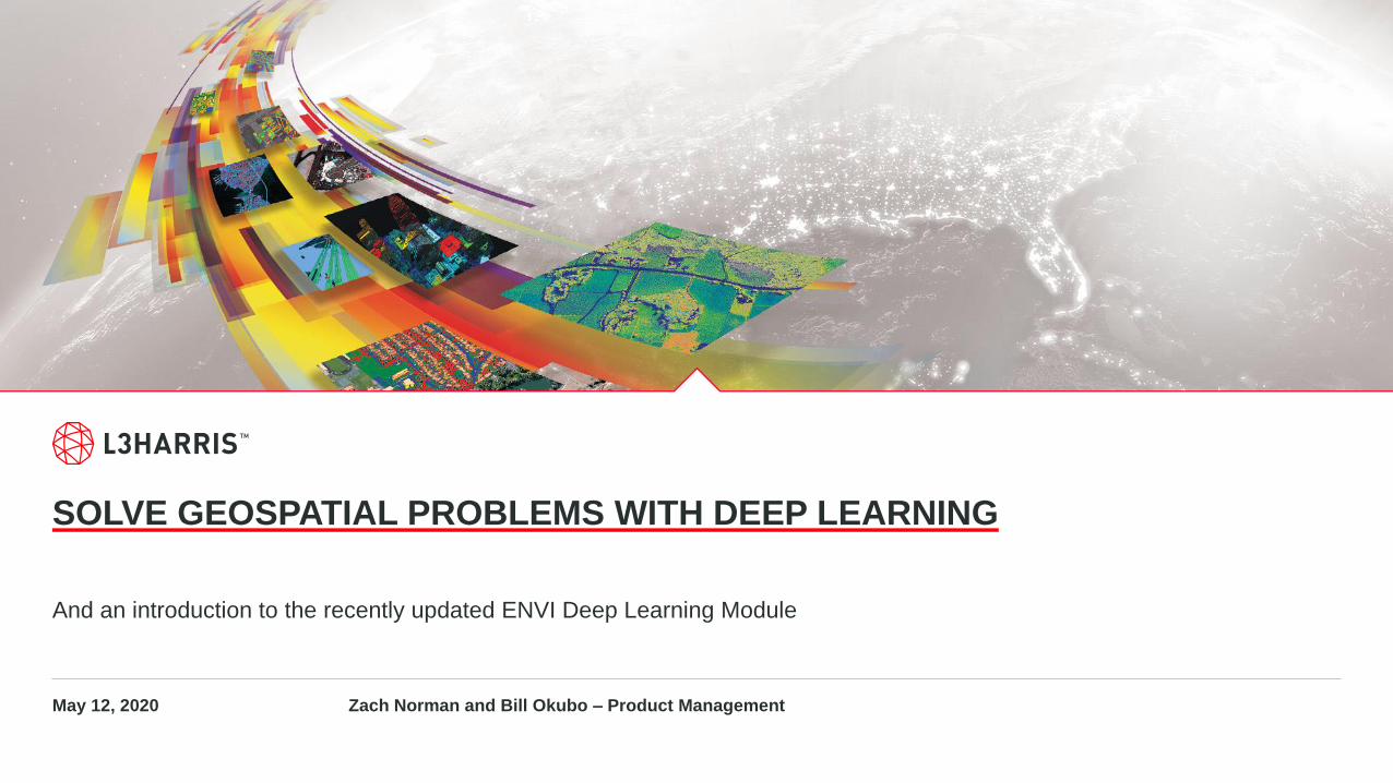
SOLVE GEOSPATIAL PROBLEMS WITH DEEP LEARNING
And an introduction to the recently updated ENVI Deep Learning Module
May 12, 2020 Zach Norman and Bill Okubo – Product Management

L3HARRIS 2SOLVE GEOSPATIAL PROBLEMS WITH DEEP LEARNING
Contact Information and Introductions
Zachary Norman
Product Manager
Bill Okubo
Product Manager
L3HARRIS 3SOLVE GEOSPATIAL PROBLEMS WITH DEEP LEARNING
Agenda
Introduction
Scenario One: Environmental Monitoring
Scenario Two: Disaster Response
• Hands-on Tutorial Overview
• Change Detection with Deep Learning
The ENVI Deep Learning Module
Additional Examples
Questions and Discussion
L3HARRIS 4SOLVE GEOSPATIAL PROBLEMS WITH DEEP LEARNING
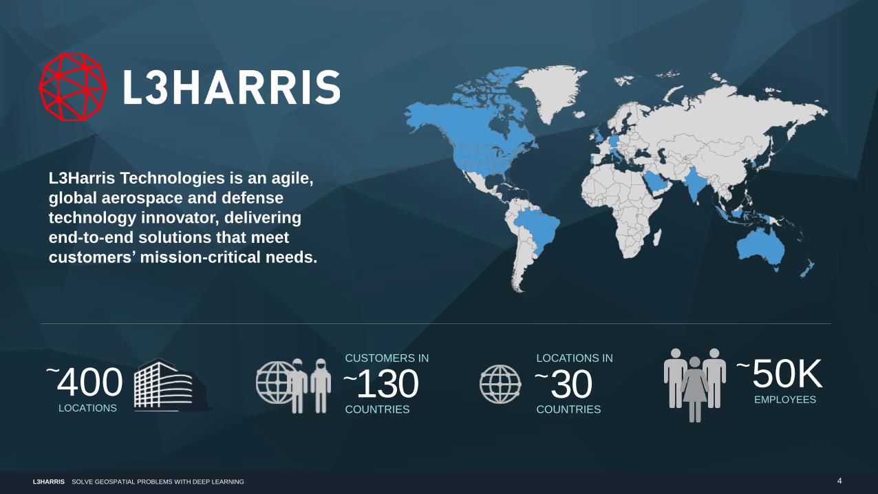
EMPLOYEES
50K~LOCATIONS IN
COUNTRIES
30~LOCATIONS
400~CUSTOMERS IN
COUNTRIES
130~
L3Harris Technologies is an agile,
global aerospace and defense
technology innovator, delivering
end-to-end solutions that meet
customers’ mission-critical needs.
L3HARRIS 5SOLVE GEOSPATIAL PROBLEMS WITH DEEP LEARNING
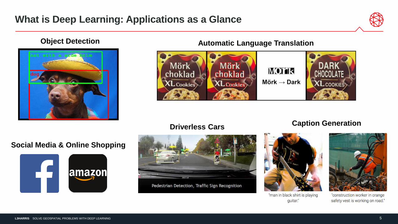
Automatic Language Translation
Driverless CarsCaption Generation
Social Media & Online Shopping
What is Deep Learning: Applications as a Glance
Object Detection
L3HARRIS 6SOLVE GEOSPATIAL PROBLEMS WITH DEEP LEARNING
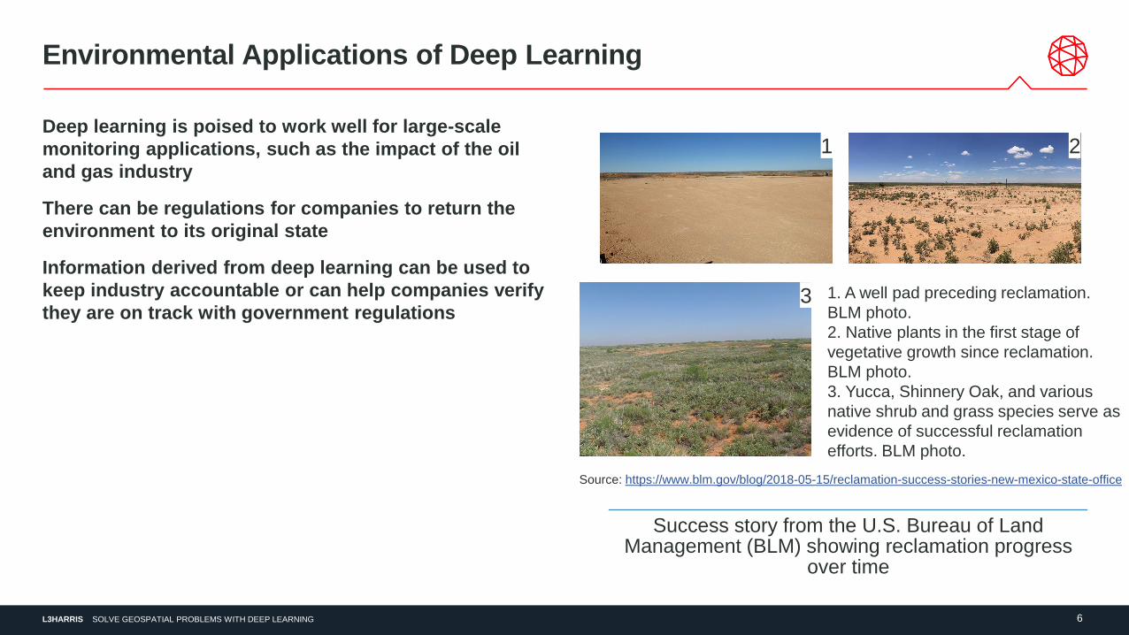
Environmental Applications of Deep Learning
Deep learning is poised to work well for large-scale
monitoring applications, such as the impact of the oil
and gas industry
There can be regulations for companies to return the
environment to its original state
Information derived from deep learning can be used to
keep industry accountable or can help companies verify
they are on track with government regulations
1 2
3 1. A well pad preceding reclamation.
BLM photo.
2. Native plants in the first stage of
vegetative growth since reclamation.
BLM photo.
3. Yucca, Shinnery Oak, and various
native shrub and grass species serve as
evidence of successful reclamation
efforts. BLM photo.
Source: https://www.blm.gov/blog/2018-05-15/reclamation-success-stories-new-mexico-state-office
Success story from the U.S. Bureau of Land Management (BLM) showing reclamation progress
over time
L3HARRIS 7SOLVE GEOSPATIAL PROBLEMS WITH DEEP LEARNING
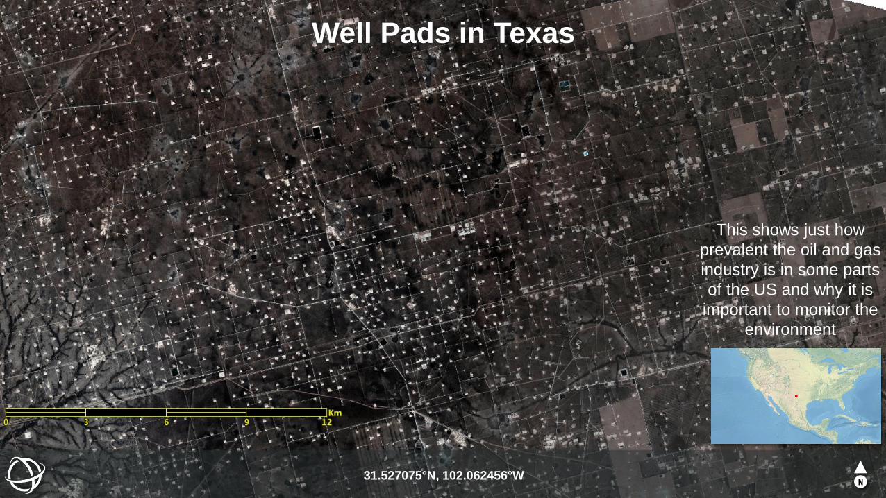
Well Pads in Texas
31.527075°N, 102.062456°WN
This shows just how
prevalent the oil and gas
industry is in some parts
of the US and why it is
important to monitor the
environment
L3HARRIS 8SOLVE GEOSPATIAL PROBLEMS WITH DEEP LEARNING
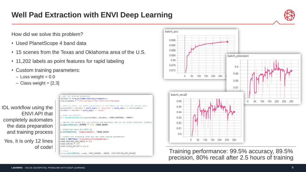
Well Pad Extraction with ENVI Deep Learning
How did we solve this problem?
• Used PlanetScope 4 band data
• 15 scenes from the Texas and Oklahoma area of the U.S.
• 11,202 labels as point features for rapid labeling
• Custom training parameters:
– Loss weight = 0.0
– Class weight = [2,3]
Training performance: 99.5% accuracy, 89.5% precision, 80% recall after 2.5 hours of training
IDL workflow using the
ENVI API that
completely automates
the data preparation
and training process
Yes, it is only 12 lines
of code!

L3HARRIS 9SOLVE GEOSPATIAL PROBLEMS WITH DEEP LEARNING
Well Pads in Texas
31.527075°N, 102.062456°WN
This shows just how
prevalent the oil and gas
industry is in some parts
of the US and why it is
important to monitor the
environment
L3HARRIS 10SOLVE GEOSPATIAL PROBLEMS WITH DEEP LEARNING
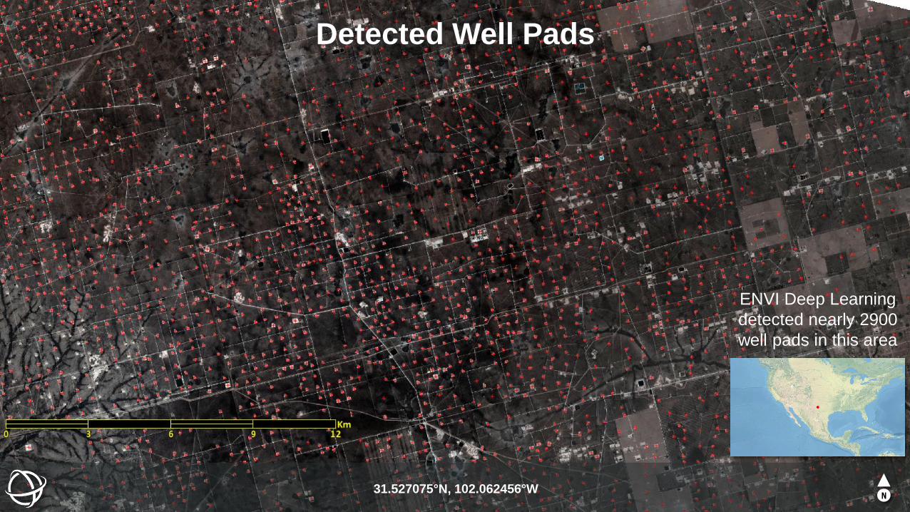
Detected Well Pads
31.527075°N, 102.062456°WN
ENVI Deep Learning
detected nearly 2900
well pads in this area
L3HARRIS 11SOLVE GEOSPATIAL PROBLEMS WITH DEEP LEARNING
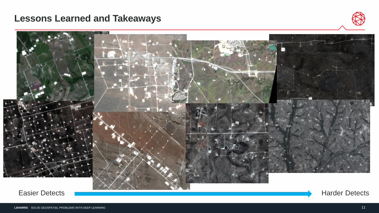
Lessons Learned and Takeaways
Easier Detects Harder Detects
L3HARRIS 12SOLVE GEOSPATIAL PROBLEMS WITH DEEP LEARNING
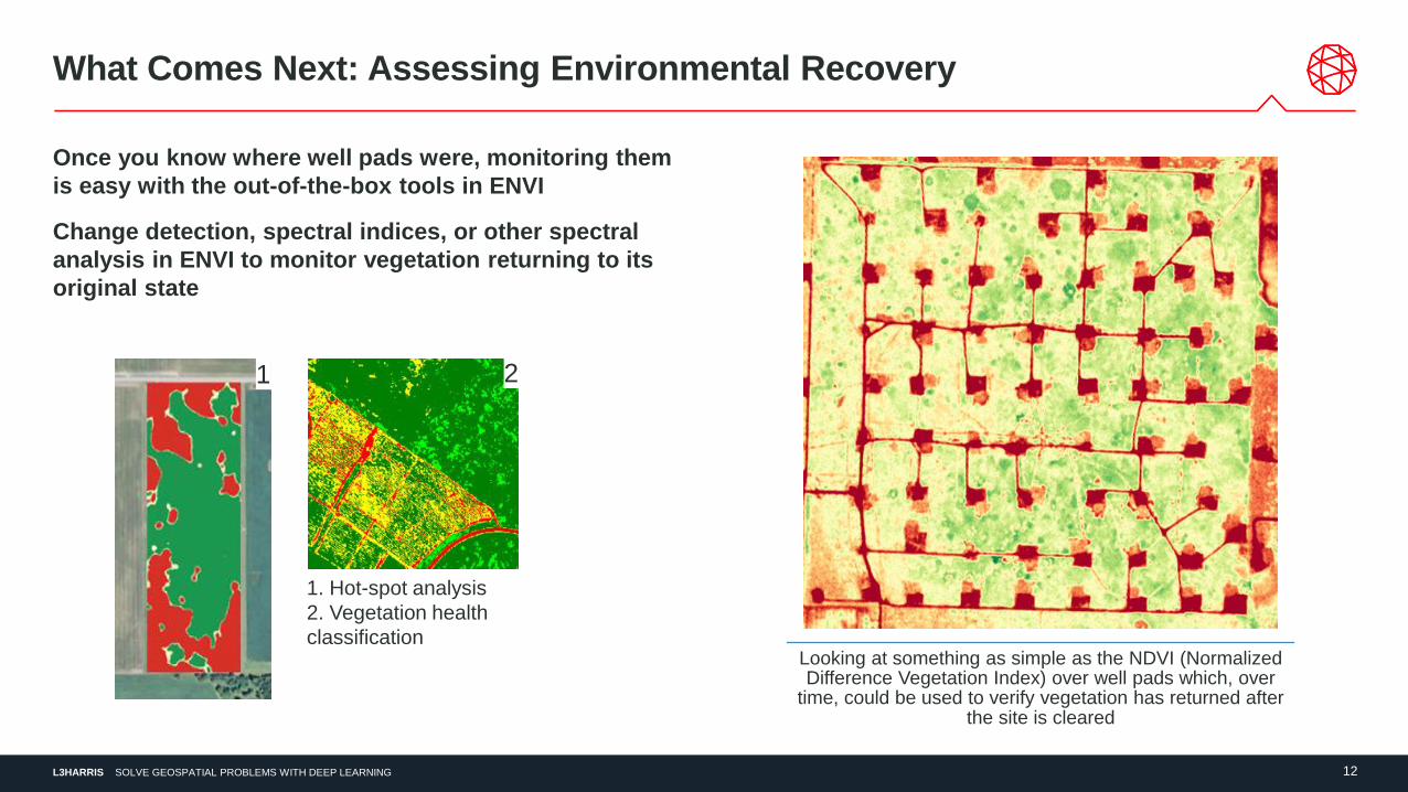
What Comes Next: Assessing Environmental Recovery
Once you know where well pads were, monitoring them
is easy with the out-of-the-box tools in ENVI
Change detection, spectral indices, or other spectral
analysis in ENVI to monitor vegetation returning to its
original state
Looking at something as simple as the NDVI (Normalized Difference Vegetation Index) over well pads which, over
time, could be used to verify vegetation has returned after the site is cleared
1. Hot-spot analysis
2. Vegetation health
classification
1 2
L3HARRIS 13SOLVE GEOSPATIAL PROBLEMS WITH DEEP LEARNING
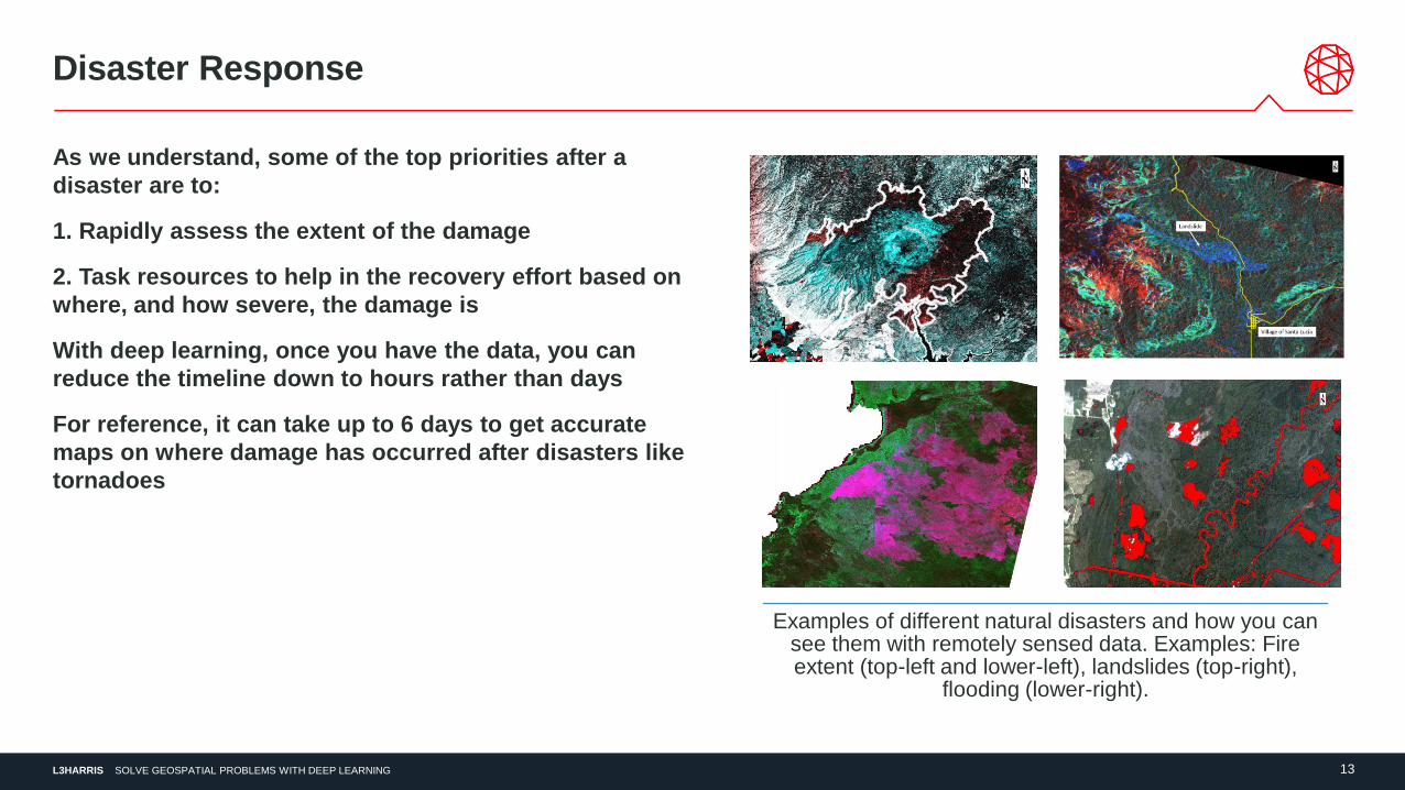
Disaster Response
As we understand, some of the top priorities after a
disaster are to:
1. Rapidly assess the extent of the damage
2. Task resources to help in the recovery effort based on
where, and how severe, the damage is
With deep learning, once you have the data, you can
reduce the timeline down to hours rather than days
For reference, it can take up to 6 days to get accurate
maps on where damage has occurred after disasters like
tornadoes
Examples of different natural disasters and how you can see them with remotely sensed data. Examples: Fire extent (top-left and lower-left), landslides (top-right),
flooding (lower-right).
L3HARRIS 14SOLVE GEOSPATIAL PROBLEMS WITH DEEP LEARNING
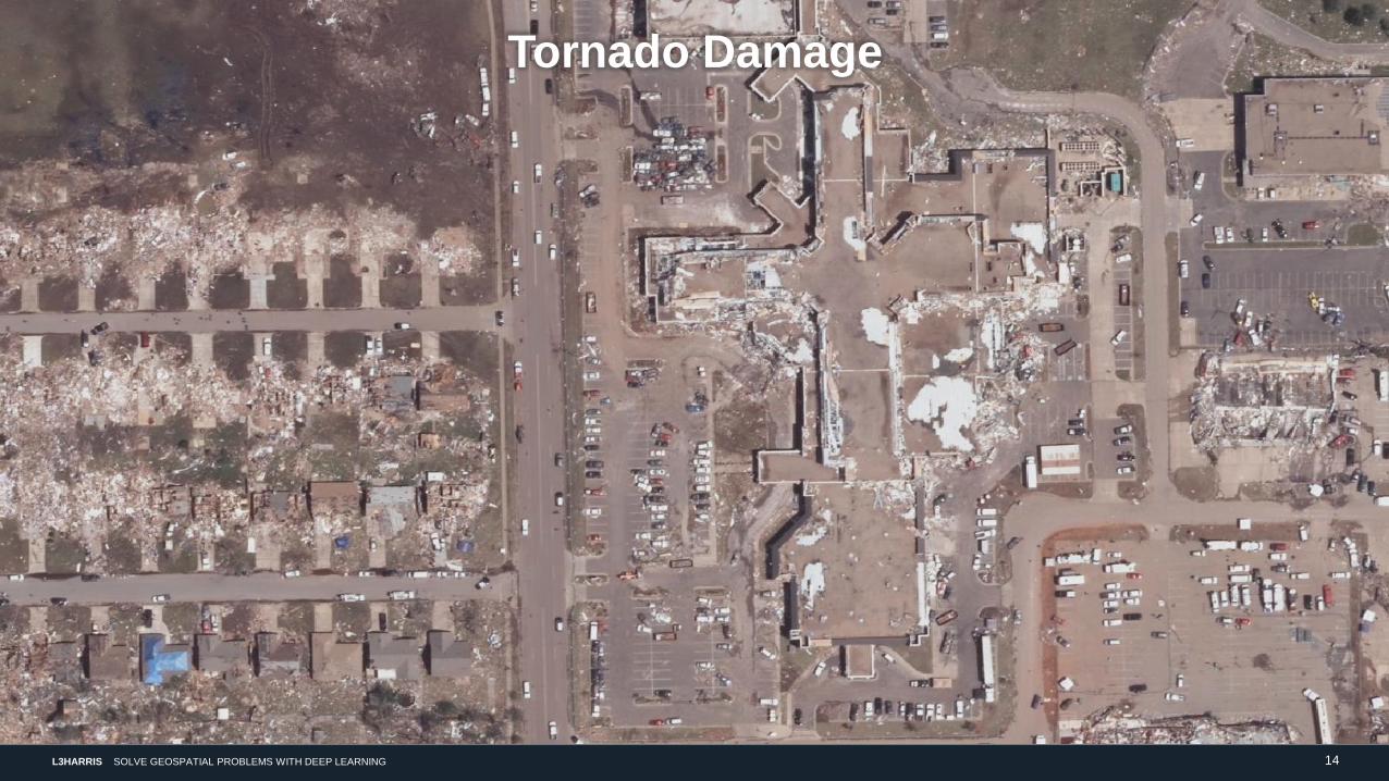
Tornado Damage
L3HARRIS 15SOLVE GEOSPATIAL PROBLEMS WITH DEEP LEARNING
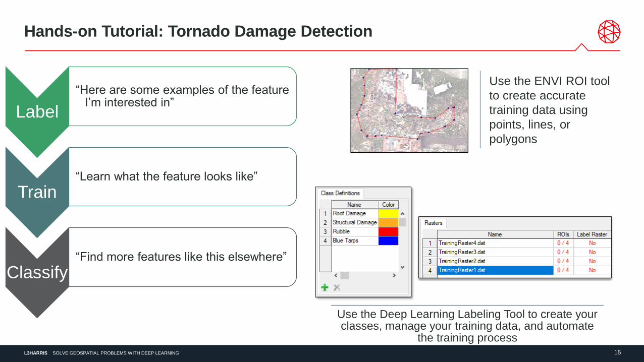
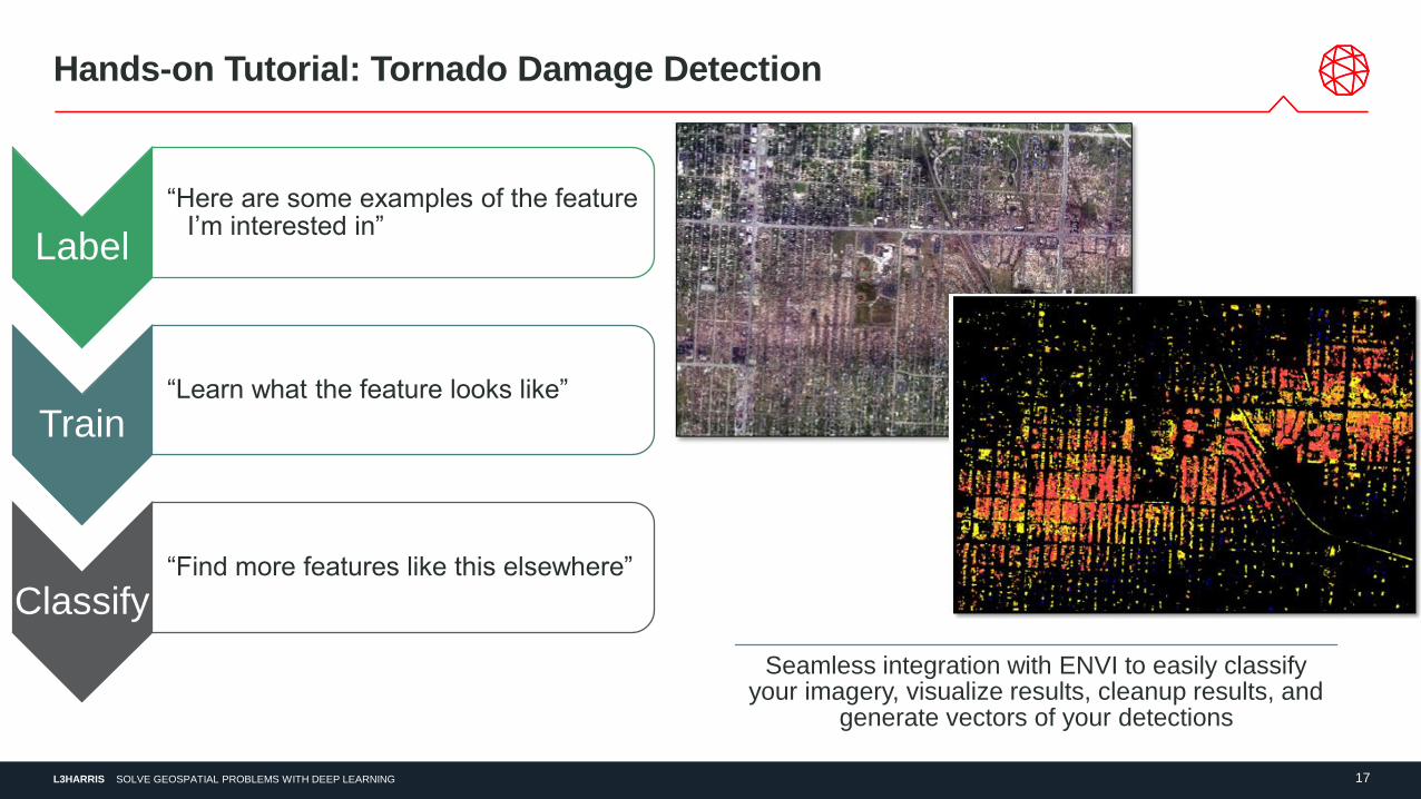
Hands-on Tutorial: Tornado Damage Detection
Label
“Here are some examples of the feature I’m interested in”
Train“Learn what the feature looks like”
Classify“Find more features like this elsewhere”
Use the Deep Learning Labeling Tool to create your classes, manage your training data, and automate
the training process
Use the ENVI ROI tool
to create accurate
training data using
points, lines, or
polygons
L3HARRIS 16SOLVE GEOSPATIAL PROBLEMS WITH DEEP LEARNING
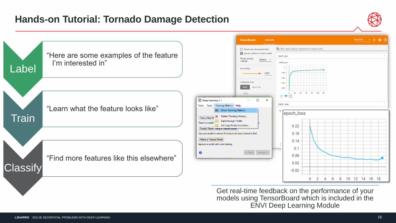
Hands-on Tutorial: Tornado Damage Detection
Label
“Here are some examples of the feature I’m interested in”
Train“Learn what the feature looks like”
Classify“Find more features like this elsewhere”
Get real-time feedback on the performance of your models using TensorBoard which is included in the
ENVI Deep Learning Module
L3HARRIS 17SOLVE GEOSPATIAL PROBLEMS WITH DEEP LEARNING
Hands-on Tutorial: Tornado Damage Detection
Label
“Here are some examples of the feature I’m interested in”
Train“Learn what the feature looks like”
Classify“Find more features like this elsewhere”
Seamless integration with ENVI to easily classify your imagery, visualize results, cleanup results, and
generate vectors of your detections
L3HARRIS 18SOLVE GEOSPATIAL PROBLEMS WITH DEEP LEARNING
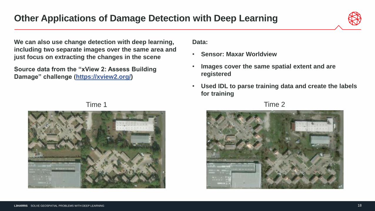
Other Applications of Damage Detection with Deep Learning
We can also use change detection with deep learning,
including two separate images over the same area and
just focus on extracting the changes in the scene
Source data from the “xView 2: Assess Building
Damage” challenge (https://xview2.org/)
Data:
• Sensor: Maxar Worldview
• Images cover the same spatial extent and are
registered
• Used IDL to parse training data and create the labels
for training
Time 1 Time 2
L3HARRIS 19SOLVE GEOSPATIAL PROBLEMS WITH DEEP LEARNING
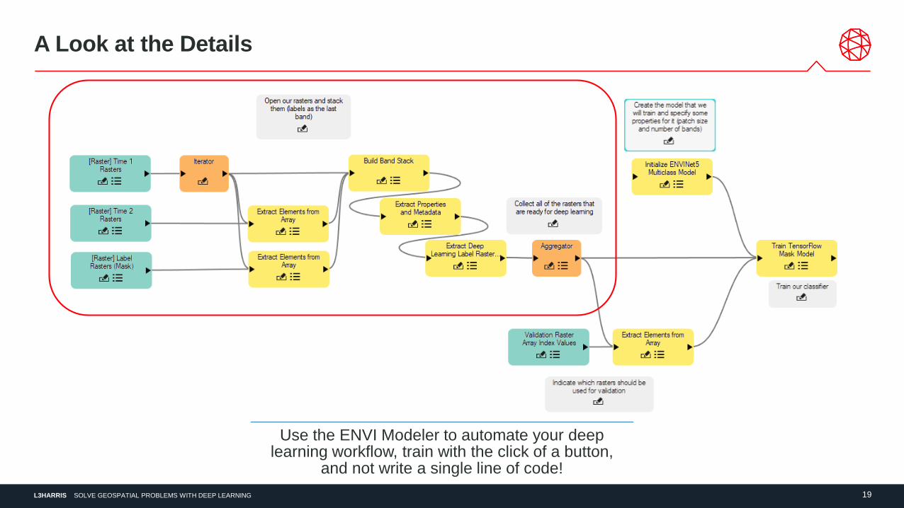
A Look at the Details
Use the ENVI Modeler to automate your deep learning workflow, train with the click of a button,
and not write a single line of code!
L3HARRIS 20SOLVE GEOSPATIAL PROBLEMS WITH DEEP LEARNING
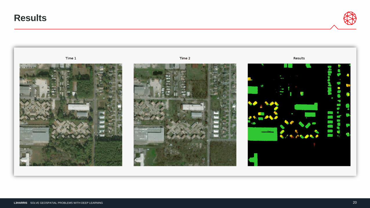
Results
L3HARRIS 21SOLVE GEOSPATIAL PROBLEMS WITH DEEP LEARNING
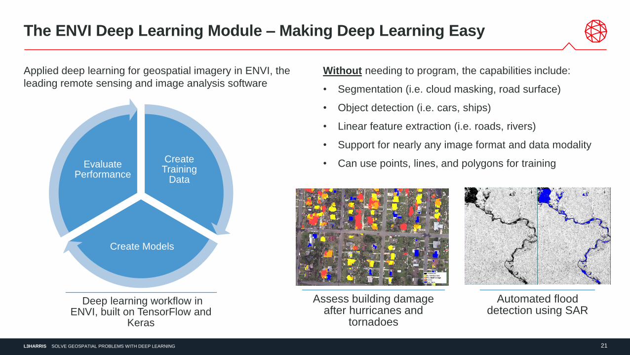
The ENVI Deep Learning Module – Making Deep Learning Easy
Applied deep learning for geospatial imagery in ENVI, the
leading remote sensing and image analysis software
Without needing to program, the capabilities include:
• Segmentation (i.e. cloud masking, road surface)
• Object detection (i.e. cars, ships)
• Linear feature extraction (i.e. roads, rivers)
• Support for nearly any image format and data modality
• Can use points, lines, and polygons for trainingCreate Training
Data
Create Models
Evaluate Performance
Deep learning workflow in ENVI, built on TensorFlow and
Keras
Assess building damage after hurricanes and
tornadoes
Automated flood detection using SAR
L3HARRIS 22SOLVE GEOSPATIAL PROBLEMS WITH DEEP LEARNING
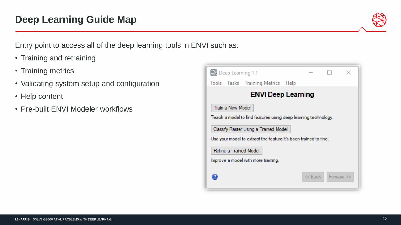
Deep Learning Guide Map
Entry point to access all of the deep learning tools in ENVI such as:
• Training and retraining
• Training metrics
• Validating system setup and configuration
• Help content
• Pre-built ENVI Modeler workflows
L3HARRIS 23SOLVE GEOSPATIAL PROBLEMS WITH DEEP LEARNING
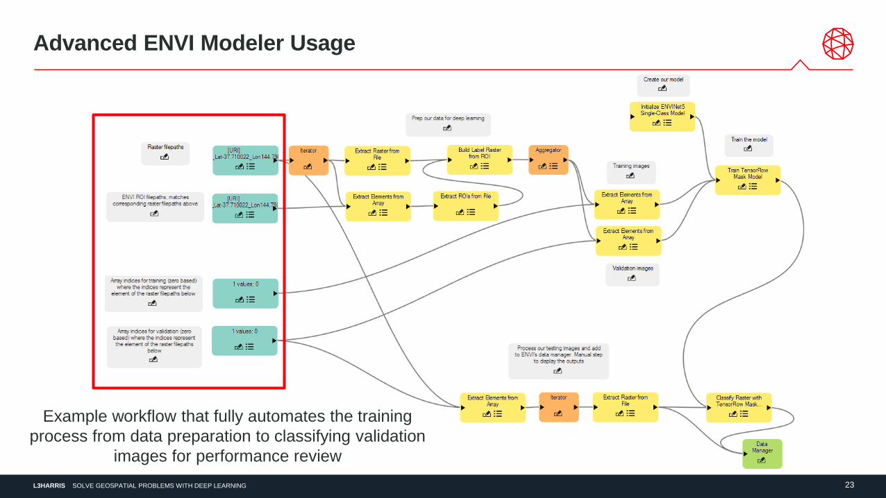
Advanced ENVI Modeler Usage
Example workflow that fully automates the training
process from data preparation to classifying validation
images for performance review
L3HARRIS 24SOLVE GEOSPATIAL PROBLEMS WITH DEEP LEARNING
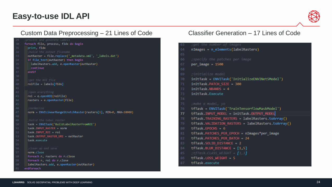
Easy-to-use IDL API
Classifier Generation – 17 Lines of CodeCustom Data Preprocessing – 21 Lines of Code
L3HARRIS 25SOLVE GEOSPATIAL PROBLEMS WITH DEEP LEARNING
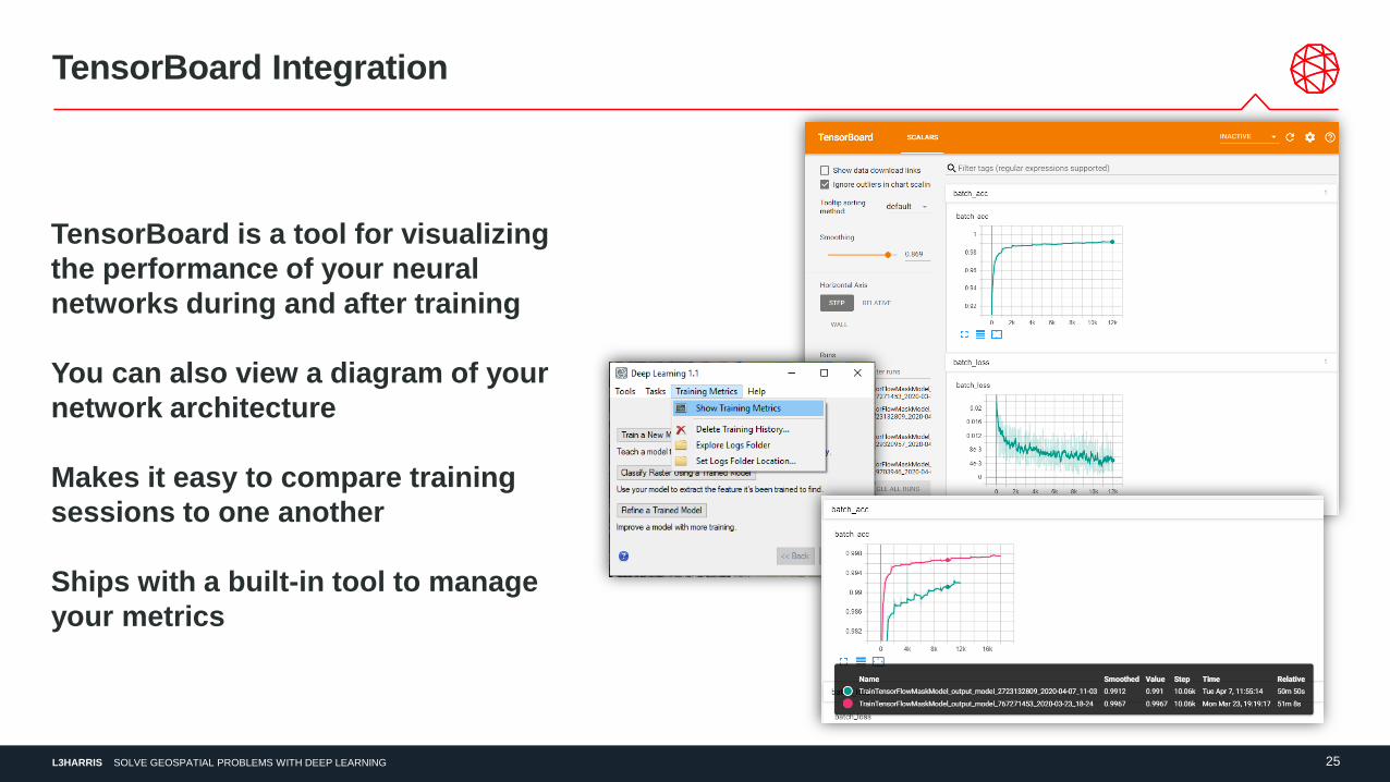
TensorBoard Integration
TensorBoard is a tool for visualizing
the performance of your neural
networks during and after training
You can also view a diagram of your
network architecture
Makes it easy to compare training
sessions to one another
Ships with a built-in tool to manage
your metrics
L3HARRIS 26SOLVE GEOSPATIAL PROBLEMS WITH DEEP LEARNING
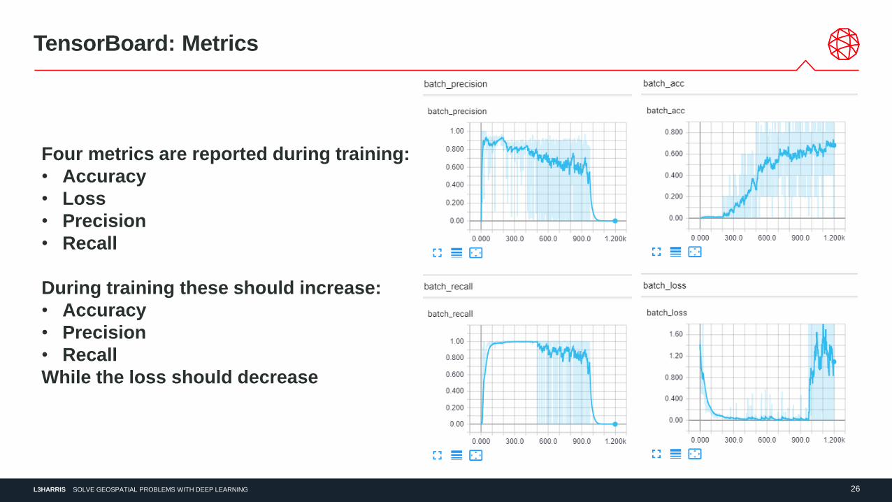
TensorBoard: Metrics
Four metrics are reported during training:
• Accuracy
• Loss
• Precision
• Recall
During training these should increase:
• Accuracy
• Precision
• Recall
While the loss should decrease
L3HARRIS 27SOLVE GEOSPATIAL PROBLEMS WITH DEEP LEARNING
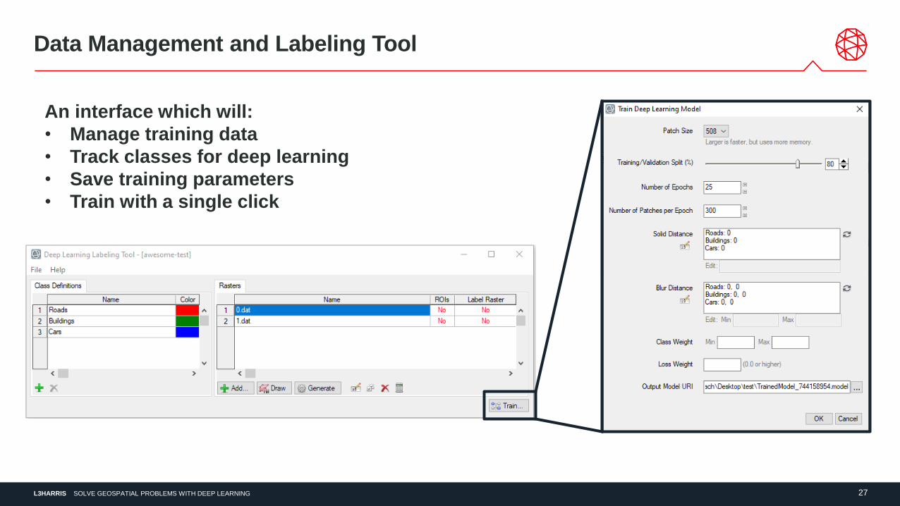
Data Management and Labeling Tool
An interface which will:
• Manage training data
• Track classes for deep learning
• Save training parameters
• Train with a single click
L3HARRIS 28SOLVE GEOSPATIAL PROBLEMS WITH DEEP LEARNING
Examples
L3HARRIS 29SOLVE GEOSPATIAL PROBLEMS WITH DEEP LEARNING
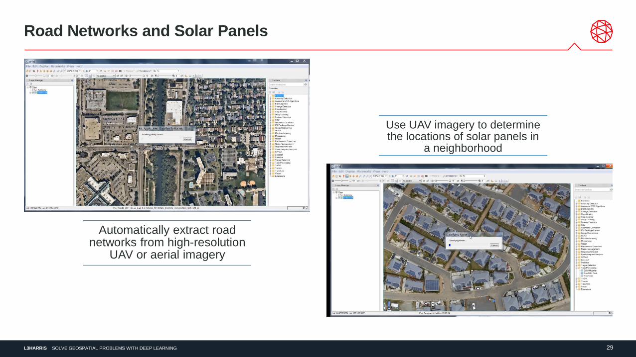
Road Networks and Solar Panels
Automatically extract road networks from high-resolution
UAV or aerial imagery
Use UAV imagery to determine the locations of solar panels in
a neighborhood
L3HARRIS 30SOLVE GEOSPATIAL PROBLEMS WITH DEEP LEARNING
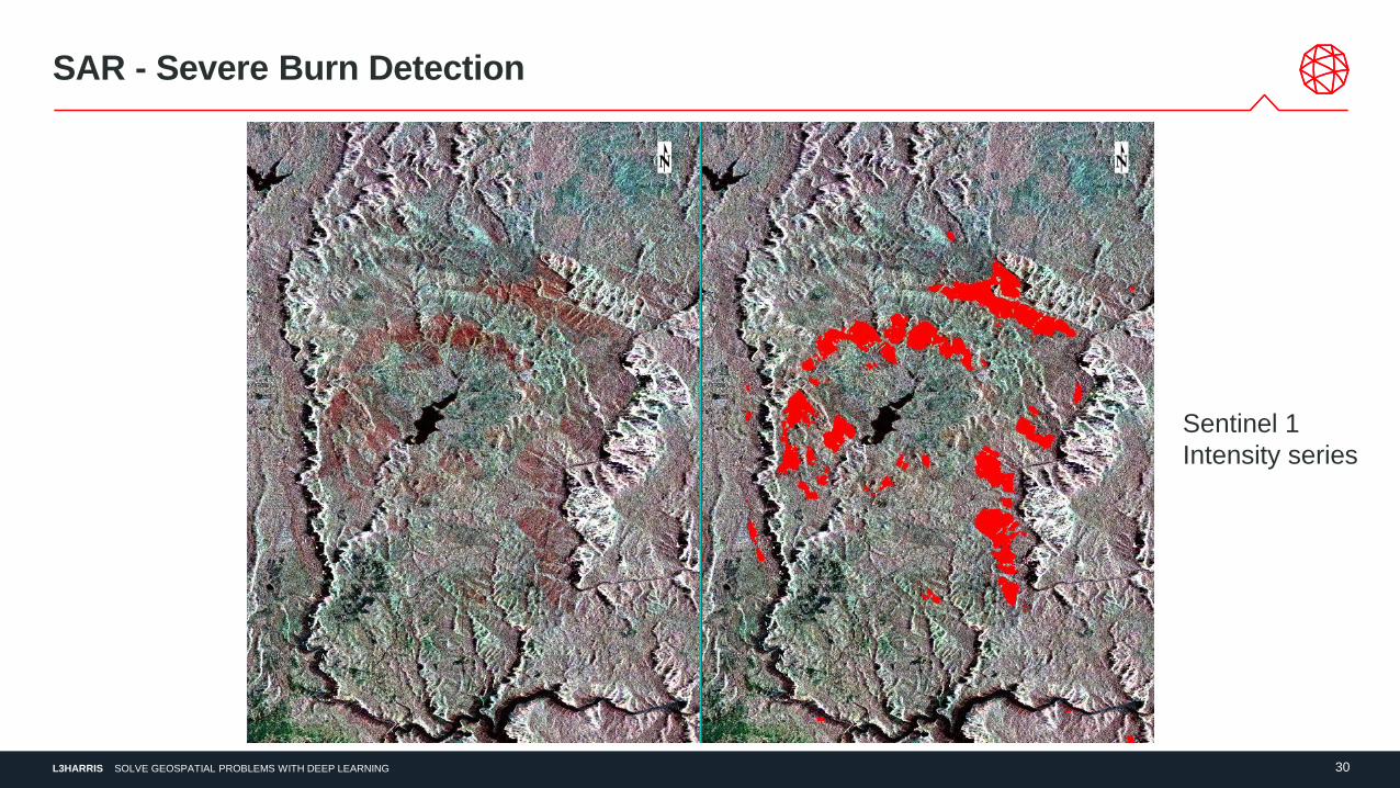
SAR - Severe Burn Detection
Sentinel 1
Intensity series
L3HARRIS 31SOLVE GEOSPATIAL PROBLEMS WITH DEEP LEARNING
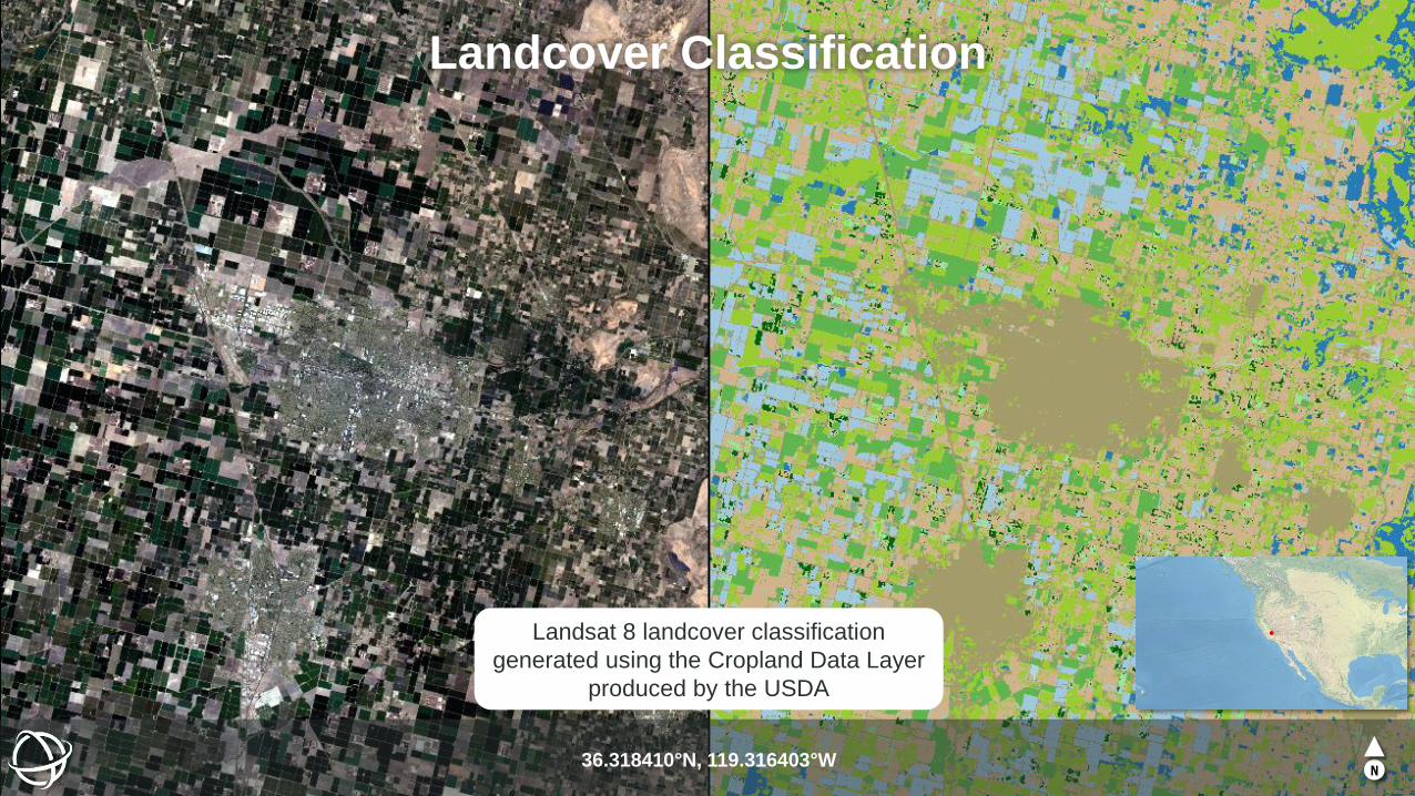
Landcover Classification
36.318410°N, 119.316403°WN
Landsat 8 landcover classification
generated using the Cropland Data Layer
produced by the USDA
L3HARRIS 32SOLVE GEOSPATIAL PROBLEMS WITH DEEP LEARNING
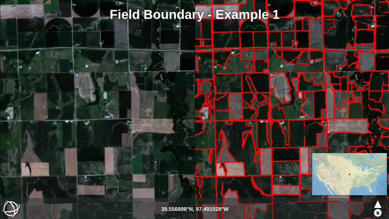
Field Boundary - Example 1
39.556898°N, 97.491028°WN
L3HARRIS 33SOLVE GEOSPATIAL PROBLEMS WITH DEEP LEARNING
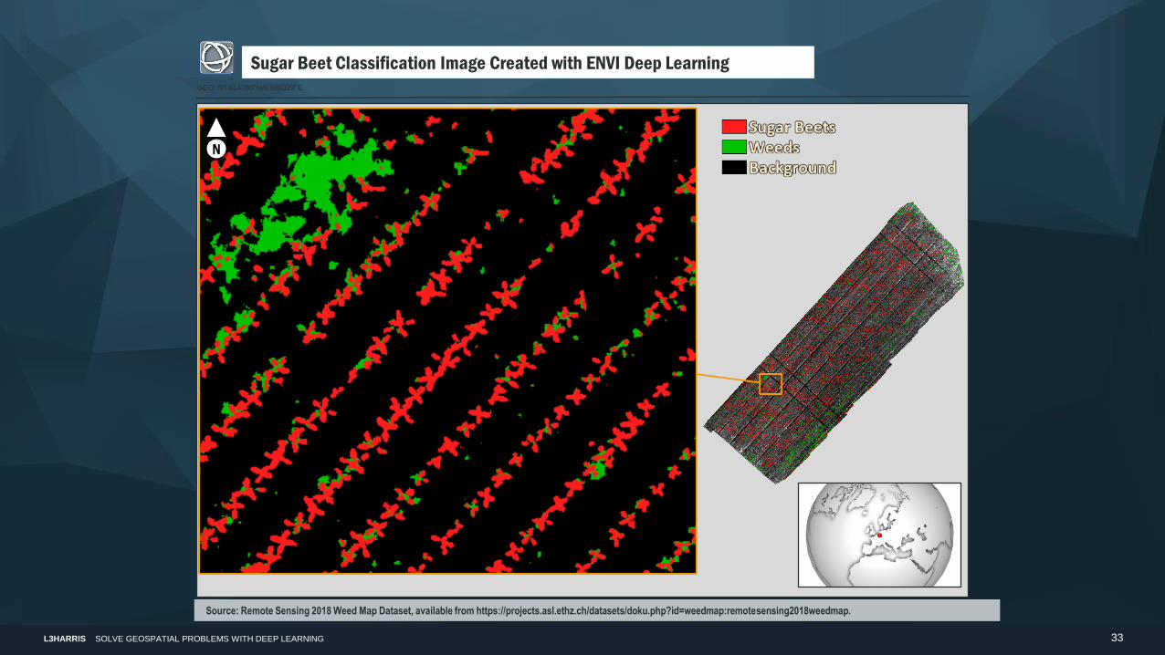
Sugar Beet Classification Image Created with ENVI Deep LearningGEO: 50.614780°N/6.989323°E
N
Source: Remote Sensing 2018 Weed Map Dataset, available from https://projects.asl.ethz.ch/datasets/doku.php?id=weedmap:remotesensing2018weedmap.
L3HARRIS 34SOLVE GEOSPATIAL PROBLEMS WITH DEEP LEARNING
L3Harris Geospatial
www.L3HarrisGeospatial.com
303-786-9900
Questions and Discussion
Release details can be found here: https://www.l3harrisgeospatial.com/Support/Maintenance
Look for the “What’s New in ENVI Deep Learning 1.1” item for more information
Zachary Norman
Product Manager
Bill Okubo
Product Manager