Embed Size (px)
Citation preview

Spednic Lake / Upper St. Croix River Management Plan
Canoeing the Upper St. Croix River
FINAL DRAFT – May 16, 2011

1

2
3
Table of Contents Table of Contents............................................................................................................................ 3 I. Introduction ................................................................................................................................ 5
About This Document................................................................................................................. 5 Map 1: Planning Area ................................................................................................................. 7
II. The Planning Process and Context............................................................................................. 8 Public Participation and the Planning Process............................................................................ 8 Statutory and Policy Guidance.................................................................................................... 8 Supporting Studies and Plans...................................................................................................... 9
III. The Planning Context ............................................................................................................. 11 Culture and History of the Region ............................................................................................ 11 Natural and Geological Resources in the Region ..................................................................... 12 Recreation Resources in the Region ......................................................................................... 13 Other Key Land Managers in the Region ................................................................................. 13 Conservation Partners ............................................................................................................... 14 Regional Conservation Efforts.................................................................................................. 14 Map 2: Regional Conservation Context.................................................................................... 17
IV. Resource, Issues and Management Recommendations .......................................................... 18 Character of the Landbase ........................................................................................................ 18 Acquisition History................................................................................................................... 18 Natural Resources ..................................................................................................................... 19 Natural Resource Management Issues and Recommendations ................................................ 22 Map 3: Spednic Lake - Special Habitat and Natural Resources ............................................... 24 Map 4: Upper St. Croix River Special Habitat and Natural Resources .................................... 25 Historic and Cultural Resources ............................................................................................... 26 Historic and Cultural Resource Management Issues and Recommendations........................... 27 Recreation Resources................................................................................................................ 27 Recreation Resource Management Issues and Recommendations ........................................... 36
404141
Transportation and Administration Considerations .................................................................. 41 Map 6: Transportation Resources ............................................................................................. 43 Transportation and Administrative Management Issues and Recommendations ..................... 44
VI. Monitoring and Evaluation ..................................................................................................... 47 Recreation ................................................................................................................................. 47 Wildlife ..................................................................................................................................... 47 Stewardship Endowment .......................................................................................................... 47
VI. Appendices ............................................................................................................................. 49
Map 5: Recreation Resources ................................................................................................... Timber and Renewable Resources............................................................................................ Timber and Renewable Resources Management Issues and Recommendations: ....................
Acknowledgments The Spednic Lake / Upper St. Croix River Management Plan was prepared through a collaborative effort involving contributions from the following Department of Inland Fisheries & Wildlife (IF&W) and Bureau of Parks & Lands (BPL) staff:
Department of Inland Fisheries & Wildlife staff Mark Caron – Region F Wildlife Biologist Tom Schaeffer – Region C Wildlife Biologist John Pratte – Wildlife Management Section Supervisor Rich Bard – Region C Assistant Wildlife Biologist Allen Starr – Region F Assistant Wildlife Biologist Greg Burr –Region C Fisheries Biologist Gordon Kramer –Region F Fisheries Biologist Bureau of Parks & Lands staff Misha Mytar – Management Plan Coordinator Will Harris – Director Kathy Eickenberg – Chief of Planning Mike Leighton – Northern Parks Regional Manager Julie McPherson – Northern Parks Assistant Regional Manager Tom Dinsmore – Property Records Specialist Brian Bronson – ORV ATV Coordinator Joe Higgins – ORV Snowmobile Coordinator
Planning information related to natural resources, especially geology and soils, hydrology and water quality, natural communities, wetlands, ecological processes, and rare plant and animal species was provided by the Maine Natural Areas Program (MNAP). Information about archaeological and historic resources was provided by Art Spiess at the Maine Historic Preservation Commission. The Bureau also acknowledges the helpful contributions of the Forest City Guides Association, St. Croix International Waterway Commission, Woodie Wheaton Land Trust, and members of the public who participated in meetings and provided information during the preparation of this Plan.
4
I. Introduction About This Document This document constitutes a 15-year Management Plan for almost 4,300 acres and 69 miles of shoreland on Spednic Lake and the Upper St. Croix River. In 2003, a multi-year effort involving many public and private partners resulted in the acquisition of approximately 51 miles (2,773 acres) of shorefront and islands within Maine’s Spednic Lake/Upper St. Croix River corridor, to be maintained for their exceptional undeveloped character and backcountry recreational values, which are of state and international significance. This was the most recent in a series of acquisitions by the State of Maine and the Province of New Brunswick to support policies for this boundary water corridor defined in the inter-governmental Plan for Long-term Cooperative Management of the St. Croix International Waterway. In addition to the 2003 acquisitions, the planning area covered in this document includes several additional properties on Spednic Lake owned or managed by the State of Maine: an 831-acre conservation easement on 14.4 miles of shoreland; 12 islands covering 44 acres (including Birch Island); and the 650-acre Booming Grounds Management Area. Lands on Spednic Lake are managed by Maine Department of Inland Fisheries & Wildlife and lands on the St. Croix River are managed by Maine Department of Conservation, Bureau of Parks and Lands. The Plan summarizes the planning process and regional context, but its primary function is to 1) provide a description of the resources found on the properties addressed, 2) describe management issues identified by members of the public and agency staff, and 3) put forth management recommendations to be implemented over the next 15-year period. The Plan is also a commitment to the public that these properties will be managed within prescribed legislative mandates and in accordance with IF&W and BPL policies. Future revisions to these commitments will occur only after providing opportunities for public comment. The Plan describes guidance to IF&W and BPL staff with responsibility for managing these properties including a degree of flexibility in achieving the stated objectives. This document is not, however, a plan of operations. An important aspect of the management of these lands will be monitoring and evaluation of proposed management activities in terms of stated objectives. The Plan describes monitoring and evaluation procedures. While the Plan will be in effect for the next 15 years, some resources and management issues may undergo more rapid and unanticipated changes. Thus, a review of current issues and progress on implementing the Plan’s recommendations will be undertaken at five-year intervals.
5

6
If amendments to the Plan are proposed, there will be an opportunity for public review and comment prior to their adoption. At the end of 15 years, IF&W and BPL will undertake a full review and revision. It is recognized all recommendations may not be accomplished within the Plan period.

7 7
Map 1: Planning Area
II. The Planning Process and Context
Public Participation and the Planning Process The management planning process included a series of steps, each involving interdisciplinary review and extensive efforts to solicit and consider public comment, in order to achieve a plan that integrates various perspectives and needs while protecting and conserving the resources within the corridor. Research and Analysis: The first phase of the planning process included a study of the resources and opportunities within the corridor. Beginning in September 2010, planning staff began to collect available information on the corridor’s natural, geological, historical and cultural, fisheries and wildlife, recreation, timber and renewable resources. Mapping and GIS-related information was also obtained as part of this phase. Planning staff also participated in two field trips to the planning area. Both trips took place in September 2010 and included a tour of the properties and close inspection of recreation facilities. The first was a canoe trip on the Upper St. Croix River from Vanceboro to Loon Bay Landing. The second was a boat tour of Spednic Lake from Vanceboro. Issue Identification/Public Scoping Session: A Public Scoping Session held in Vanceboro on October 27, 2010 to hear from the public regarding concerns for the future management of the properties. Following this scoping session, meetings were held with representatives from several stakeholder groups including Forest City Guides Association, Woodie Wheaton Land Trust, St. Croix International Waterway Commission, Woodland Pulp, and U.S. Customs and Border Protection. First Draft Circulated for Public Comment: The First Draft Plan was circulated for public comment on April 20, 2011. A public written comment period extended until May 10, 2011. Public Meeting and Comment Period for the Final Draft Plan: A Final Draft Management Plan was circulated on May 16, 2011. A Public Meeting was held in Vanceboro on May 31, 2011 to present and hear public input on the proposed plan. A period for public written comments extended until June 14th, 2011. Review of the Proposed Plan and Plan Adoption: Statutory and Policy Guidance Department of Inland Fisheries & Wildlife Currently the Department does not have an approved Integrated Resource Plan (IRP), although a draft document as been prepared. Work on the Department’s Wildlife Management Areas (WMA) is guided by a SOP manual. This manual is designed to be used by the biologists of IF&W’s Wildlife Division. It seeks to consolidate the many considerations inherent in managing
8

Department lands into one accessible source. The manual is not a wildlife habitat management handbook per se. Rather, it recognizes that each of the Department's wildlife management areas is composed of a unique set of biological circumstances and conditions, which demand site-specific management. Consequently, the manual promotes original thinking, creativity, and flexibility among the Division's biologists. At the same time, it provides a standardized, statewide framework for wildlife management area development and enhancement. Formal WMA Plans for each WMA are also required and are updated every five years. Bureau of Parks & Lands The Bureau’s Integrated Resource Policy (IRP) provides direction to the Bureau as it relates to the management of various resources on Public Reserved and Nonreserved Lands, State Park Lands, and State Historic Sites. This policy directs the Bureau to identify and protect important natural, geological, and historic attributes; enhance important fisheries and wildlife habitat; provide opportunities for a variety of quality outdoor recreation experiences; and, for Public Reserved and Nonreserved Lands, provide a sustained yield of forest products by utilizing forest management techniques and silvicultural practices that enhance the forest environment. The Upper St. Croix River Corridor is designated as State Park Land and the IRP recognizes that State Park Lands will be managed primarily for public recreational or conservation purposes pursuant to Title 12 MRSA § 1801.7. Although statutory requirements regarding the development of management plans are specific to Public Reserved and Nonreserved Lands, the intention is to develop these plans for State Parks Lands and Historic Sites as well. The Bureau’s St. Croix River property is similar to a number of other state park properties such as the Allagash Wilderness Waterway and the Penobscot River Corridor, which are managed as part of the state park system but with customized management plans and rulemaking processes. As opposed to developed State Parks, these properties are often much less developed or undeveloped entirely. Supporting Studies and Plans Over the past three decades, numerous studies and plans have been prepared which provide valuable information on the St. Croix Waterway and guidance for its management of its shorelands:
1982 – The Maine Rivers study identified a 56 mile segment of the St. Croix River from Spednic Lake to Oak Point as one of the State’s 20 “Class A” river segments based on a statewide valuation of natural and recreational values of river resources.
1984 – The Province of New Brunswick nominated the St. Croix River for inclusion in the Canadian Heritage Rivers System for the purpose of providing a representation of natural maritime river environments of prehistoric and early European history in Eastern Canada and for the purpose of providing an outstanding recreational experience for various types of river tourists.
1987 – The St. Croix International Waterway Commission was established by the Province of New Brunswick and the State of Maine to develop and facilitate the implementation of an international plan to protect, manage and develop the heritage resources of the St. Croix boundary corridor.
1991 – A comprehensive summer use survey was carried out on the St. Croix River by the Waterway Commission.
9
1993 – A “Plan for Long-term Cooperative Management of the St. Croix International Waterway” was prepared and accepted in 1994 by Maine and New Brunswick, establishing international management goals, policies and recommended actions. This document outlines specific policies for the conservation and recreational management of the Spednic Lake/ Upper St. Croix River corridor that have resulted in subsequent conservation actions and, ultimately, the current planning process.
1998 – The “St. Croix River: State of the Watershed” report was prepared for the International St. Croix River Watershed Board and the International Joint Commission to help inform and educate, and to support the development of a common understanding and vision for natural resources in both Maine and New Brunswick.
1998 – A “Resource & Recreation Management Concept” proposal was prepared for the Spednic Lake/Upper River Section by the St. Croix International Waterway Commission but not pursued at that time.
1999 – A “Recreational Use Assessment of the St. Croix International Waterway was performed by the University of New Brunswick and University of Maine which provides an overview of recreational user characteristics and opinions.
2006 – The Maine Department of Inland Fisheries & Wildlife developed its management plan for the Booming Grounds Wildlife Management Area.
2009 – The Maine Department of Conservation published its “Eastern Interior Region Management Plan” which constitutes a 15-year management plan for over 57,000 acres of public reserved land in the Eastern Interior region of Maine managed by the Maine Bureau of Parks and Lands. While the Eastern Interior Region extends to the St. Croix Waterway, the plan did not cover the Bureau’s St. Croix River ownership as it is managed as State Park Lands rather than Public Reserved Lands.
This planning effort recognizes that the St. Croix Waterway boundary corridor continues to be guided by the 1993 “Plan for Long-term Cooperative Management of the St. Croix International Waterway”. This Spednic Lake/Upper St. Croix River Management Plan focuses only on specific state-owned or managed lands along the waterway. It is intended to complement the 1993 plan by addressing the need for additional resource and recreational management guidance for these lands in order to retain a high quality backcountry experience, maintain efficiencies in recreation management, and protect the undeveloped character and natural resources of this outstanding corridor.
10
III. The Planning Context The major focus of this document is to plan for the future of the state-owned and managed lands on Spednic Lake and the Upper St. Croix River. However, an overview of the region’s culture and history, natural and wildlife resources, other public and private conservation lands, and other topics, gives important context. The Spednic Lake and the Upper St. Croix River properties are part of the St. Croix River Watershed, which covers an area of 1,649 square miles along the Canada and United States border between New Brunswick and Maine. The 110-mile waterway serves as a natural boundary between Canada and the United States. The St. Croix River, including its headwater lakes, is one of three international boundary rivers in Maine (the St Croix, the St. John, and the St. Francis rivers). It is one of only two international waterways in the country which have received international protection status based on outstanding recreational values, ecological assets, and an undeveloped natural setting, the other being the Boundary Waters Canoe Area between the State of Minnesota and the Province of Ontario. Culture and History of the Region Because of its location, the river has played a unique role in U.S. and Maritime Canadian history. First inhabited almost 11,000 years ago, the St. Croix River Basin has since been continuously occupied. Native peoples, including the Passamaquoddy who still reside in the region today, have used the river as a travel route between traditional coastal and inland settlements and as a connection between the Penobscot and St. John river basins. The St. Croix River Basin contained timber reserves of white pine, spruce, fir and hemlock; fisheries of alewives, shad and salmon; agricultural resources in hay (salt marsh and fresh water meadows), blueberries and peat, and an abundance of water power by which to develop industries of a scale sufficient for permanent settlement and the production of exportable goods. Recorded Euroamerican history begins in 1604 when French explorers established the first New World colony north of Florida on St. Croix Island, located in the estuarine portion of the river. The St. Croix basin was subsequently settled by the English and others. After the American Revolutionary War in 1780, the region began to develop into one of the Northeast's major lumbering and shipbuilding centers. Logs were hauled from inland forests and cascaded to coastal mills and shipyards. Many of the present St. Croix lakes and flowages were created or enlarged by dams installed in the 1880s for seasonal log driving and, since the early 1900s, maintained to help generate hydropower for wood processing. Beginning in the 1800s, the St. Croix region also established a widespread reputation as a premiere sport fishing destination that continues to this day. The St. Croix River Basin’s natural, cultural and historical resources continue to support the local economy. With forest land covering about 80% of the watershed land area, wood harvesting and processing is the most important industry in the area. The watershed also
11
provides abundant recreational opportunities and wildlife habitat, which support a significant regional tourism economy—the second largest component of the local economy on Maine’s side of the waterway. The Waterway’s lakes are managed to provide fisheries and wildlife habitat benefits and for water storage to regulate downstream flows. Natural and Geological Resources in the Region The Physical Landscape: Geology, Soils and Hydrology Maine’s portion of the St. Croix River Basin is characterized by gently rolling hills and low, rounded mountains. Elevations average between 100 and 1,000 feet. Bedrock in the northern parts of the basin is almost entirely composed of interbedded shale, sandstone, and limestone. As you travel south, the sedimentary and metamorphic rocks become intruded by igneous rocks. In the southernmost parts of the basin, the bedrock becomes igneous. The lowlands are covered by marine sediments while thin, stony till and stratified drift overlie the rest of the bedrock. Deposits of swamps, marshes and bogs composed of peat, clay, silt and sand are scattered through the area. The area’s surface geology has been strongly influenced by the last ice age which carved the lakes, valleys and glacial flood plains. The region exhibits glacial features including kames, eskers, and terraces. Present day changes are caused by the remarkable tides in the estuary and by the freshwater processes that continue to mold the region’s lakes, river corridor and wetlands. There are two principal chains of lakes in the St. Croix watershed: the east branch chain of lakes (or Chiputneticook lake system) located along the international border and the west branch lakes, located on the Maine side of the watershed. The east branch lakes include two of the largest lakes in both Maine and New Brunswick: Spednic and East Grand Lake. The West Branch lakes include West Grand Lake, Big Lake, and others. The east and west branch lake systems converge at Grand Falls Flowage at Kellyland. From this point, the St. Croix continues for approximately 18 miles to head-of-tide at Calais and St. Stephen where it joins with the St. Croix estuary, a 15-mile stretch of saline water connected to Passamaquoddy Bay influenced by twice-daily, 23-foot tides. Passamaquoddy Bay is a sub-basin of the Bay of Fundy. According to the National Wetlands Inventory, freshwater forested, shrub and emergent wetlands cover 76,219 acres of the St. Croix basin in Maine. Freshwater emergent wetlands account for 10% of these wetlands while freshwater forested and shrub wetlands make up for the other 90%. Large peatlands are dispersed occasionally throughout the basin. Two exemplary bog communities have been identified by the Maine Natural Areas Program close to the river. An eccentric bog ecosystem is located approximately 1,500 feet from the river in Vanceboro and a Sheep laurel dwarf shrub bog is located approximately 2,500 feet from the river in Fowler Twp. The Biological Landscape: Forest Types, Plants and Animals The landscape of the St. Croix River Basin is about 80% forested in hardwood and conifer forest. Disturbance from fire is rare, although historical documentation of fire occurrence in this region shows considerable variability through time. Severe wind events can cause considerable blowdown in forested communities near coastal areas. Tidal flooding associated with storms occurs along the coast. Insect and disease disturbances have resulted from hemlock looper,
12
spruce budworm, and European larch canker. Severe impacts have resulted from beech bark disease. Two hundred and fifty years of land use activity have affected forest structure and composition across the landscape. The land has been both selectively and intensively logged throughout since the late 1700s. Land has been cleared and farmed since the time of early settlement. Beginning around 1870, land unprofitable for agriculture was abandoned and much was allowed to revert to forest. The natural communities of the basin provide habitat for a number of wildlife species, including snowshoe hare, pine marten, fisher, coyotes, bobcats, black bears, white-tailed deer and moose. Common loons, bald eagles, ospreys, and otters commonly use the many large lakes, rivers, and flowages. Beaver commonly alter drainways and wetlands through damming activities. The fresh waters support regionally-important populations of landlocked salmon, lake trout and smallmouth bass, including an ecologically significant river population of the latter. The St. Croix was one of the East Coast’s more important Atlantic salmon rivers. In addition to the species noted above, the St. Croix estuary supports hundreds of marine animals, including jellyfish, bivalves, crustaceans, sea cucumbers, sea urchins, flatworms and migrant fishes. Recreation Resources in the Region The large land base, series of interconnected lakes and streams, and tidewaters provide opportunities for recreational fishing, boating, canoeing, swimming and other sports, along with many forms of nature appreciation. Hiking, cross-country skiing, snowshoeing, snowmobiling, ATV riding, wildlife viewing and camping are popular land-based activities. A limited number of campgrounds and boat accesses throughout the watershed, and a series of campsites along the boundary waters, serve the recreational public. Thirteen snowmobile clubs manage over 300 miles of trails across the St. Croix River Basin in Maine. Nine ATV clubs manage over 400 miles of trails throughout the St. Croix River Basin in Maine. A vast majority of these trail systems are on private land. The Bureau’s Off-road Vehicle Division (ORV) provides grants to these organizations in support of these trail systems. The St. Croix region is thought to represent the highest density of employment in the sporting camp and guiding businesses in Maine. Sport fishing in the St. Croix area has been popular since the late 1700s, with sportsmen from North America and Europe coming to the St. Croix region for its world renowned outdoor and fishing opportunities. Other Key Land Managers in the Region Much of the landscape in the region is managed in large tracts by industrial and timber management landowners. Wagner Timber Partners, Baskahegan Company, Woodland Pulp, Downeast Lakes Land Trust, and the Passamaquoddy Tribe are some of the key land managers in the planning region. IF&W and BPL communicate with these landowners and consider their various management styles in making decisions on state-managed lands.
13
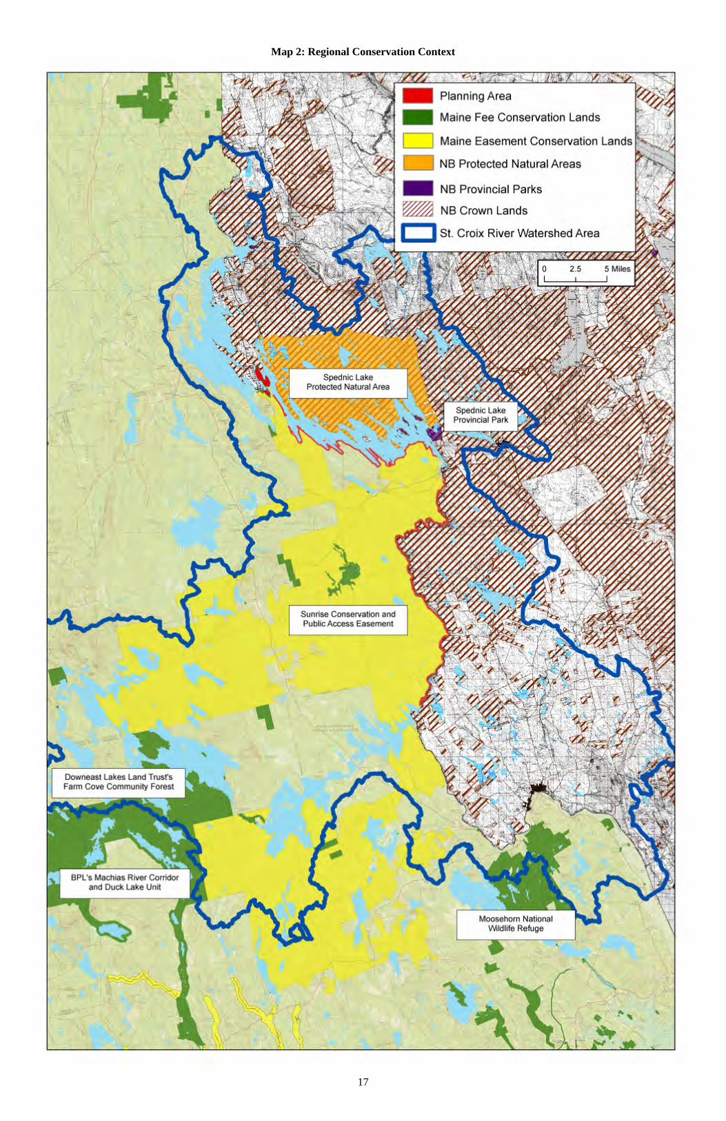
Conservation Partners St. Croix International Waterway Commission (The Waterway Commission) The St. Croix International Waterway Commission was established under Maine and New Brunswick legislation in 1987 to develop and help implement a long term comprehensive management plan for the St. Croix boundary corridor. Preserving the outstanding recreational and natural heritage of the Spednic Lake/Upper St. Croix River portion of the waterway was a primary driver of this international plan. Over the last two decades the Waterway Commission has encouraged and worked with Maine, New Brunswick and broad range of non-governmental partners to secure the Spednic Lake/Upper St. Croix River protection achieved to date. It has also maintained the St. Croix River facilities for much of this time and has secured funding from various sources for campsite maintenance, recreational and resource studies, planning and conservation work. Woodie Wheaton Land Trust (WWLT) The Woodie Wheaton Land Trust’s mission is to protect and preserve land and waters in the Chiputneticook Lakes Region of Maine and New Brunswick. Their conservation goals include securing permanent public access to land and water to ensure ongoing opportunities for nature-based tourism, recreational use, natural-resource-dependent employment, and aesthetic appreciation of scenic and wildlife values. WWLT has played a lead role in several conservation initiatives within the planning corridor and around the region. New England Forestry Foundation (NEFF) The New England Forestry Foundation is dedicated to providing for the conservation and ecologically sound management of privately owned forestlands in New England, throughout the Americas and beyond. The New England Forestry Foundation joined with WWLT, the Waterway Commission, IF&W and BPL to purchase the fee-owned land in the planning corridor. NEFF established the Stewardship Endowment to support the management of Spednic Lake and Upper St. Croix River lands held in fee or managed by IF&W, BPL or WWLT. NEFF has also played a lead role in other regional conservation initiatives. Downeast Lakes Land Trust (DLLT) The mission of the Downeast Lakes Land Trust is to contribute to the long-term economic and environmental well-being of the Downeast Lakes region through the conservation and exemplary management of its forests and waters. DLLT sustainably manages the 33,708-acre Farm Cove Community Forest, with 71 miles of lakeshore, for wildlife habitat, forest products, and public recreation and has played a key role in regional conservation initiatives through the Downeast Lakes Forestry Partnership. Regional Conservation Efforts Over 700,000 acres – two-thirds of the St. Croix River watershed— are under some form of protection and approximately 42% of the watershed is now permanently protected. Of the permanently protected lands, about 80% are located in Maine. The following timeline summarizes a selection of conservation initiatives within or near the planning area.
14
1937 – Moosehorn National Wildlife Refuge purchases with Duck Stamp funds and established by Franklin Delano Roosevelt. It is one of the oldest National Wildlife Refuges and a part of the early conservation movement in America.
1968 – New Brunswick establishes Spednic Lake Provincial Park, and expands it in 1971.
1983 – Maine imposes a 250 foot no development zone along the St. Croix River from the north end of Wingdam Island to Grand Falls Flowage, through the Maine’s Rivers Act.
1992 – Maine purchases 650 acres and four miles of shorefront on Spednic Lake, Mud Lake and Mud Lake Stream, at Forest City, from Georgia-Pacific Corporation, through the Land for Maine’s Future Program. IF&W now manages these lands as the Booming Grounds Wildlife Management Area.
1994 – Maine acquires a conservation easement on 16 miles of Spednic Lake shorefront and purchases 11 Spednic Lake islands in fee from Baskahegan Company, through the Land for Maine’s Future Program
1995 – Maine purchases a 0.6 acre parcel on Mud Lake through the Land for Maine’s Future Program
1995 – Woodie Wheaton Land Trust purchases Birch Island and Little Birch Island, on Spednic Lake, for permanent protection.
1995 – New Brunswick institutes a 75 meter no-development zone along the upper St. Croix River and a 100 meter no-development zone along Spednic Lake.
1995 - Maine receives donation of 144 acres of shorefront land on The Arm, on East Grand Lake. The land is managed by IF&W.
1995 - New Brunswick permanently protects 11 islands (totaling 15.6 acres) in the Grassy Island chain, on the upper St. Croix River, as a provincial ecological reserve.
1996 to 1998 – WWLT purchases the 25-acre Birch Island and Little Birch Island on Spednic Lake through the Land for Maine’s Future Program. Birch Island was later conveyed by WWLT to the State of Maine (IF&W) with restrictive deed covenants.
1999 – Woodie Wheaton Land Trust receives the donation of Freda Island, at Mud Lake in Forest City.
2001 – New Brunswick purchases Georgia-Pacific Corporation’s provincial land holdings, which include a large portion of the St. Croix watershed, for retention as forest land.
2001 – The Nature Trust of New Brunswick receives the donation of a 361-acre property on the upper St. Croix River at Clark’s Point, above Grand Falls Flowage.
2002 – St. Croix Estuary Project purchases a 330-acre property at Todd’s Point on the New Brunswick side of the St. Croix estuary. This has become the area’s first community-owned nature and marine park.
2003 – New Brunswick permanently protects 63,715 acres of land and boundary waters at Spednic Lake, designating these as the province’s second largest protected natural area. It similarly protects another 10,089 acres on the Canoose Flowage that drain to the upper St. Croix River.
2003 – Fee purchase by the State of Maine of 51 miles (2,773acres) of 500-foot shoreland corridor and islands on the lower end of Spednic Lake and the upper St. Croix River. IF&W manages the state’s shorelands on Spednic Lake; BPL manages the state’s
15

16
shorelands and islands on the river. Spednic Lake lands were purchased by WLLT and subsequently conveyed to the State of Maine (IF&W) with restrictive deed covenants.
2005 - Nature Trust of New Brunswick establishes the 30 acre Pagan Point Nature Reserve on the shores of Passamaquoddy Bay, at St. Andrews.
2005 – St. Croix International Waterway Commission, in collaboration with state, federal and local funding partners (including the Land for Maine’s Future Program), completes the fee purchase of 300 shorefront acres on the St. Croix estuary, in Calais. This Devil’s Head Conservation Area is owned by the City of Calais under a permanent protection agreement with BPL.
2005 – Downeast Lakes Forestry Partnership purchases conservation and public access easements that permanently protect 315,000 acres in the St. Croix watershed. Known as the “Sunrise Easement”, New England Forestry Foundation holds the conservation easement and BPL holds a public access easement on these lands which directly abut the planning area.
2005 – Downeast Lakes Land Trust acquires the 27,080–acre Farm Cove Community Forest as part of Downeast Lakes Forestry Partnership.
2006 – The Nature Trust of New Brunswick receives one of the largest ecological gifts of its kind in Canada, a conservation easement on the 2,313-acre MacNichol property along the upper St. Croix River, above Grand Falls Flowage.
2008 – WLLT purchases Greenland Island, a scenic 6-acre island located next to one of the best salmon fishing holes on East Grand Lake.
2009 - Nature Trust of New Brunswick establishes the 28 acre Navy Island Nature Preserve and the 13-acre Leigh Williamson Conservation Easement on a St. Croix estuary island off St. Andrews, NB
Map 2: Regional Conservation Context highlights some of the protected lands in and around the planning area.
17
Map 2: Regional Conservation Context
IV. Resource, Issues and Management Recommendations Vision for Spednic Lake / Upper St. Croix River The following Vision statement is intended to guide the future management of Maine’s Spednic Lake and Upper St. Croix River corridor lands. The Spednic Lake and Upper St. Croix River corridor lands provide traditional, backcountry recreational experiences in a near-wilderness environment with exceptional scenic, natural, cultural and historic values. Primitive recreational facilities are maintained to an exemplary standard with as little impact as possible on the natural character of the land. Recreational and resource information is available through a variety of means. The lands are efficiently and effectively managed through strong partnerships between state and international management agencies, conservation organizations, adjacent landowners, recreation clubs, local businesses and communities. Character of the Landbase Spednic Lake Spednic Lake is one of the largest lakes in Maine. It is largely undeveloped, being surrounded primarily by commercial forestland and conservation land and is notable for its finger-like glacial peninsulas, exceptional recreational fishing. Its 17-mile length contains roughly 200 miles of mainland and island shore frontage. Spednic Lake and its associated shoreland, wetland and upland areas provide a variety of recreational opportunities, including fishing, hunting, boating, camping and nature study. The planning area is 2,503 acres and includes 34-miles of shoreline and 12 islands (totaling 44 acres) in Spednic Lake in Forest City Twp, Forest Twp, T 11 R3 NBPP and the Town of Vanceboro. The primary focus of the Plan is a 500-ft deep shoreland corridor acquired in 2003 - 15.8 miles (978 acres) owned in fee, with the remaining 14.4 miles (831 acres) under conservation easement. The planning area also includes the 650-acre Booming Grounds Wildlife Management Area. Upper St. Croix River The upper section of the St. Croix River, from the base of Spednic Lake to Grand Falls Flowage, is also surrounded by forestland. It is one of the region’s most popular backcountry canoe waters. The planning area includes a 35.2-mile, 500-foot riparian strip (1,750 acres) and a number of islands (totaling 44.3 acres) on the river in the Town of Vanceboro, Lambert Lake Twp, Dyer Twp, and Fowler Twp. This land is owned by the Bureau of Parks and Lands and designated as State Park Land. Acquisition History The State has acquired the planning area through four separate transactions, all supported by the Land for Maine’s Future Program:
18
1994 – Purchase by the State of Maine of 1) conservation easements on 831 acres, creating a 500-foot wide conservation corridor along over 14 miles of undeveloped shorefront on Spednic Lake (see Appendix A); and 2) fee ownership of 11 small islands in Spednic Lake totaling 19 acres, in the mid-section of the lake.
1996 – WWLT purchases the 25-acre Birch Island and later conveyed the island to the State of Maine (IF&W) with restrictive deed covenants (see Appendix B).
1998 – Maine purchases 650 acres and four miles of shorefront on Spednic Lake, Mud Lake and Mud Lake Stream, at Forest City, from Georgia-Pacific Corporation, through the Land for Maine’s Future Program. IF&W now manages these lands as the Booming Grounds Wildlife Management Area.
2003 – Fee purchase by the State of Maine of 51 miles (2,773acres) of 500-foot shoreland corridor and islands on the lower end of Spednic Lake and the upper St. Croix River. IF&W manages the state’s shorelands on Spednic Lake; BPL manages the state’s shorelands and islands on the river. Spednic Lake lands were purchased by WLLT and subsequently conveyed to the State of Maine (IF&W) with restrictive deed covenants (see Appendix C).
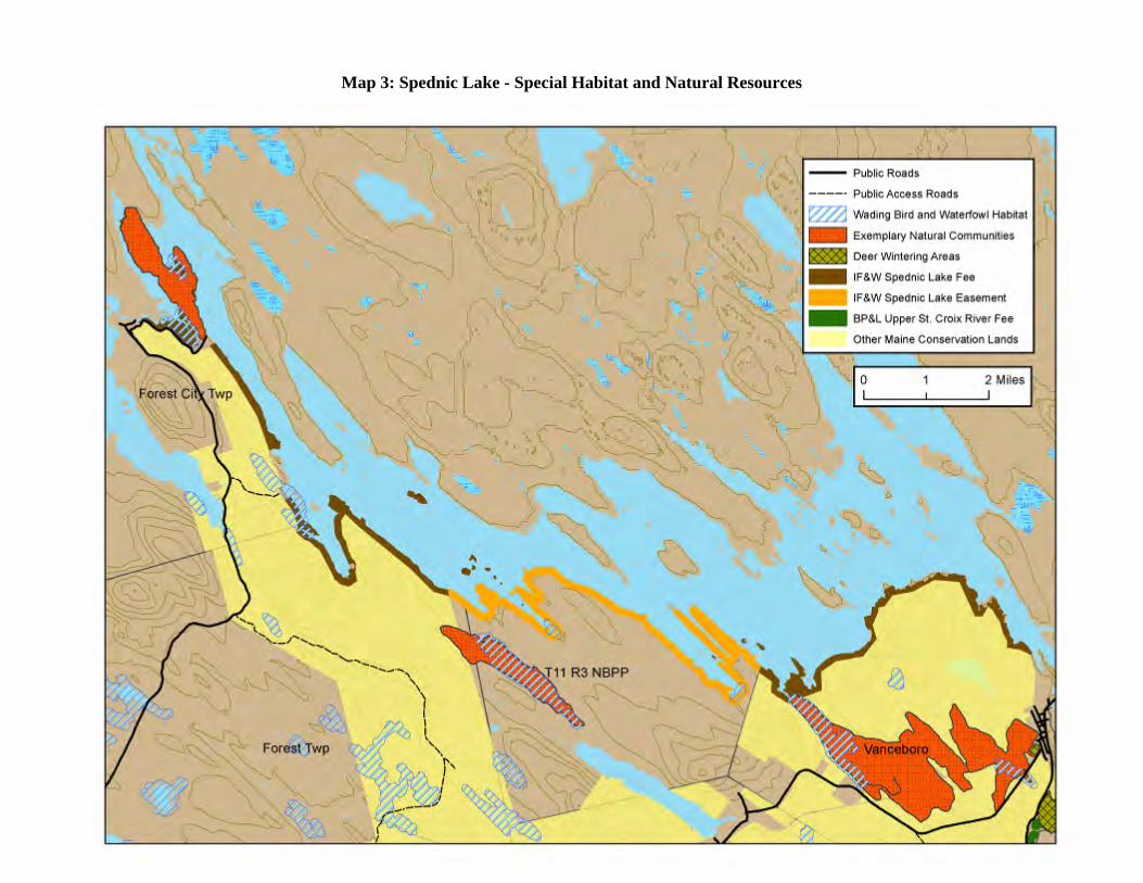
Natural Resources Geology and Soils Spednic Lake and the Upper St. Croix River are located within two of Maine’s principal geographic regions: the Norumbega Hills subregion of the larger Upper Hilly region, which surrounds Spednic Lake, and the Eastern Peatlands Region, which surrounds the river from Vanceboro to Grand Falls flowage. The hills of this region are underlain by igneous bedrock, particularly the granites, and most are rounded monadnocks. The region is cut across by eskers, many of which project into Spednic Lake as narrow peninsulas and form deep protected coves. Eskers are also evident in the area from Vanceboro to Dyer Township, forming ridges running northwest to southeast separated by diverse wetlands and small streams that drain into the St. Croix River. In Fowler Township, the last 5 to 6 miles before Grand Falls Flowage, the river meanders through an extensive wetland typical of the Eastern Peatlands Region. Hydrology, Water Quality and Quantity Hydrology All the water in the planning area flows into Spednic Lake and the Upper St. Croix River which converges with the west branch system at Grand Falls flowage and drain into the St. Croix estuary and, eventually, Passamaquoddy Bay. Water Quality Water quality within the Spednic Lake/Upper River area is excellent. The area’s water quality is protected by Maine’s high water standards (GPA classification o the lakes and A classification on the river) that permits new discharges only if these are of a quality equal to or better than natural waters. In 2000, New Brunswick adopted a surface water classification system compatible with Maine’s system. The International Joint Commission (IJC) has established transboundary guidelines for dissolved oxygen and pH for all St. Croix freshwaters and can recommend other international guidelines at its discretion. Water quality studies have been performed by the Waterway Commission, Maine Department of Environmental Protection, US
19
Environmental Protection Agency, Environment Canada and New Brunswick Department of the Environment. Water Quantity Water quantity in the upstream lakes and main stem of the river is regulated and managed in order to balance uses including the environment, recreation, and power production. Minimum flows have been established for several of the dams as well as maximum and minimum water levels for the storage reservoirs. Both the Forest City and Vanceboro dams are operated by Woodland Pulp in part as hydropower storage facilities but also to maintain minimum flows, prevent flooding and benefit fisheries and recreation objectives. While the Plan outlines some background information related to operation of the Forest City and Vanceboro dams, it is not intended to be a forum for identifying dam management issues or recommendations. Lake level and river flow conditions are subject to national and international regulations and, to a lesser extent, are guided by state fisheries management requests and the recreational recommendations that are outlined in the 1993 Waterway Plan. The International Joint Commission (IJC) was established under the 1909 Boundary Waters Treaty to a) issue conditions and approvals for US/Canada boundary water uses that affect levels and flows and b) carry out studies and address specific boundary issues referred to it by the two federal governments. The IJC has regulatory authority over the Forest City, Vanceboro and Grand Falls dams that affect use of the planning area. The Forest City Dam is pending a U.S. Federal Energy Regulatory Commission (FERC) relicensing decision after the previous license expired in 2000. The Vanceboro Dam’s license is due to expire in 2016 and the owner is currently preparing years in advance to begin the relicensing process. Both the IJC Commission and FERC specify the following legal operating requirements for the Vanceboro dam, which controls Spednic Lake levels and St. Croix River flows:
Maximum lake elevation: 385.85 feet above sea level. Minimum lake elevation, October 1 to April 30: 371.5 feet above sea level. Minimum lake elevation, May 1 to September 30: 376.5 feet above sea level. Minimum water discharge below the dam: 200 cubic feet per second.
IF&W maintains a letter of agreement with the dam owners to seek to hold Spednic Lake levels, May 25 – July 15, within 1 foot of the May 25 level in order to enhance smallmouth bass spawning in the lake. Fisheries & Oceans Canada requires that an operational fishway be maintained in the Vanceboro dam. Other operating practices may, at the dam owner’s discretion, apply to these:
Preferred minimum lake elevation, May 1 to September 30: 378.5 feet, for lake recreation.
Preferred river flow, May 20 to September 30: 650-750 cubic feet per second, for river recreation.
20
Staged river flow reductions (these at 25% every 4 hours) to avoid fish stranding in the river.
Current and historic water data can be accessed through the St. Croix River Basin Cooperative Hydrologic Network website (http://me.water.usgs.gov/stcroix.html). Flows over 350 cubic feet per second are canoeable; 650-750 cubic feet per second is preferred. Additionally, Woodland Pulp maintains a phone line for flow level information (207-427-3117). Natural Communities Maine Natural Areas Program has no records of rare or exemplary communities within the Upper St. Croix River corridor while just 5 acres of a Domed Bog Ecosystem crosses into the Spednic Lake corridor in Vanceboro. Wildlife and Wildlife Habitat Spednic Lake and its environs support a great diversity of wildlife, including large mammals such as moose, deer, and bear. Ospreys, bald eagles, cormorants, loons, great blue herons, geese and ducks are also common. Bald Eagles The St. Croix Waterway was once known for having one of the highest concentrations of bald eagles in Maine, largely attributed to significant nonbreeding eagle population during alewife runs. With changes in the alewife population, the nonbreeding eagle population has declined. However, the number of breeding eagles has continued to steadily rise over the past 25 years. There are currently two known nests locations within the planning area. Two additional nests are located across the river in Canada and three additional nests are located just north of the planning area on Spednic Lake. Inland Wading Bird and Waterfowl Habitat Spednic Lake lands have a total of 87 acres of wading bird and waterfowl habitat—51 within the state’s fee ownership and 36 within the easement lands. The Upper St. Croix River corridor has 233 acres of wading bird and waterfowl habitat. Deer Wintering Areas Deer Wintering Areas, also known as deer yards, serve an important biological role for deer in that the softwood cover reduces snow depths, blocks icy winds, and, especially in the case of cedar, provides access to a browsing opportunity not requiring the expenditure of excessive energy. Only one mapped Deer Wintering Area has been identified by IF&W in the planning corridor, near Wingdam Island on the Upper St. Croix River. However, IF&W is currently in the process reinventorying and remapping deer habitat on the Upper St. Croix River and has tentatively identified over 2/3 of the river corridor as areas where deer have been known to over-winter and also cross into Canada. Fisheries Spednic Lake is an excellent warmwater game fish habitat. Historically, Spednic Lake supported one of the most productive smallmouth bass fisheries in eastern Maine. In the early 1980s, after guides and biologists noted a decline in the smallmouth bass population, studies were initiated to
21
identify smallmouth bass recruitment issues, and remedial action was taken to address a number of those issues. The lake was subsequently closed to all harvest of bass in 1988 to start the rejuvenation of the bass population. Although the lake is still closed to the taking of bass, the population has made a dramatic recovery in the ensuing 20+ years since the closure. So much so that anglers and biologist’s alike hope to be able to open the lake to bass harvest sometime in the future. Spednic Lake also has some notable smelt spawning habitat, and does provides very limited landlocked salmon spawning and nursery areas. Hatchery reared landlocked salmon are stocked annually to supplement the small, wild salmon population, and support a very popular fishery. Landlocked alewives were illegally introduced upstream in East Grand Lake sometime in the 1990s, and have since migrated downstream to Spednic Lake. Other known species include: brown bullhead, creek chub, common shiner, cusk, American eel, fallfish, golden shiner, lake whitefish, ninespine stickleback, chain pickerel, pumpkinseed sunfish, pearl dace, rainbow smelt, white perch, white sucker and yellow perch. The freshwater fish species that are known to inhabit the St. Croix River Drainage include: landlocked salmon, smallmouth bass, brook trout, white perch, yellow perch, chain pickerel, white sucker, lake trout, lake whitefish, round whitefish, slimy sculpin, rainbow smelt, landlocked alewife, golden shiner, common shiner, blacknose dace, fallfish, burbot, American eel, banded killifish, creek chub, pumpkinseed sunfish, brown bullhead, redbreast sunfish, bridled shiner, threespine stickleback, ninespine stickleback and northern redbelly dace. In the main stem of St. Croix River and its impoundments below the Vanceboro Dam to tide-water, there are primary sport fisheries for smallmouth bass, landlocked salmon, brook trout, white perch and chain pickerel. The Plan does not address fisheries management issues. Fisheries management within the waterway is. is coordinated between IF&W’s regional offices in Enfield and Jonesboro and with the New Brunswick DNR in other forums that also allow for public input. Natural Resource Management Issues and Recommendations:
Management Issue Management Recommendation Water quantity: Lake level and river flow conditions can have a significant impact on the corridor’s natural and recreational resources. Water levels and flows can affect recreation resources through effects on the “floatability” of the river, and ease of access to put-ins, take-outs and campsites on the lake and river. Natural resources can be affected by impacts of flows and water levels on streambank and shoreline erosion, flooding, and effects on fisheries habitat in both the lake and river.
IF&W and BPL should continue dialogue with dam owners in the interest of continuing lake levels and river flows that support traditional backcountry recreation and natural resource conservation.
Bald Eagles: Bald eagle nesting can be impacted by visible or highly audible recreation uses, particularly where eagles are
The Bureau should continue dialogue with IF&W on bald eagle nesting areas and follow National Bald Eagle Management Guidelines
22
23
not accustomed to these uses. There are currently two known nest locations within the planning area.
for camping areas. These guidelines recommend a 330-foot buffer during the breeding season. No buffer is necessary around nest sites outside the breeding season.
Deer Wintering Area Management: IF&W considers deer wintering area management to be the most pressing habitat concern on the St. Croix River. Because most recreation use on the river occurs during summer there is little conflict between recreational uses and deer wintering habitat. Management of the corridor lands must recognize the dual objectives of protecting the backcountry recreation experience while supporting enhancement of the riparian area for deer habitat.
The Bureau’s management of its river corridor lands should achieve the dual objectives of supporting IF&W’s objectives for providing quality deer wintering habitat in this region, and maintaining a natural undisturbed character that protects a high quality backcountry recreation experience. Use of the Bureau’s visual class system would be an appropriate tool to guide this management.
24
Map 3: Spednic Lake - Special Habitat and Natural Resources
25
Map 4: Upper St. Croix River Special Habitat and Natural Resources
Historic and Cultural Resources The St. Croix River Basin has been continuously occupied by Indian tribes for over 11,000 years and is the homeland of the Passamaquoddy tribe which has reservation lands at Indian Township on Grand Falls Flowage and Big Lake, and at Pleasant Point on Passamaquoddy Bay. The St. Croix Waterway straddles the international border and archaeological surveys have been conducted by both Maine and New Brunswick archaeologists, with an exchange of survey results and occasional co-operative field effort. New Brunswick began with assessments of archaeological sites in the lakes in the early 1980s. Subsequently, several reconnaissance-level archaeological studies were conducted on Maine’s shoreline of Spednic Lake, largely in response to due diligence requirements of conservation land purchases and hydro-electric re-licensing. Relatively little intensive archaeological excavation has been done, so detailed analyses in this region are rare. The following studies have included visits to collectors willing to share their information, visits to the site locations to assess site integrity, and walking the lake shoreline in an attempt to locate new sites.
A 1984 survey conducted by the University of Maine conducted a survey in of the Chiputneticook Lakes area.
A 1992 survey for purchase of much of the peninsula north of Forest City Landing with some shoreline just east of Forest City with LMFB funds.
A 1994 reconnaissance archaeological survey for purchase of a conservation easement along approximately 16 miles of shore front on Spednic Lake with LMFB funds.
A 1995 reconnaissance archaeological survey and follow-up, intensive archaeological survey at specific sites associated with the hydroelectric relicensing for the Forest City Dam.
In 2001 the Maine Historic Preservation Commission crew revisited sites on the Birch Islands, a response to LMFB purchase. Both sites were found to be completely eroded.
A 2003 archaeological survey on Spednic Lake in response to the purchase proposal for this planning area. Because of low water levels, no survey was conducted at this time for the 33 miles of river downstream from Vanceboro.
In many cases, present day campsites on both Spednic Lake and the Upper St. Croix River are close to locations used traditionally for thousands of years by Native American water travelers. On Spednic Lake, five known archaeological sites have been identified close to established campsites. However, all five sites have been confirmed by the Maine Historic Preservation Commission to be non-significant based on current knowledge. Within the Booming Grounds WMA, the Hawthorne Carry site is considered to be of special interest as an excellent survival of a prehistoric Native American carry trail. This portage trail is considered to be eligible for registration with the National Register of Historic Places and has been recommended for that nomination by the Maine Historic Preservation Commission. The St. Croix River is a different matter because less inventory work has been performed. Two known archaeological sites have been identified near established campsites in the planning area and are listed as potentially significant. However both archeological sites appear to be a sufficient distance from the campsites to prevent conflicts with archaeological resources.
26
Historic and Cultural Resource Management Issues and Recommendations:
Management Issue Management Recommendation Archaeological Resources: Very little is known about the archaeology on the Upper St. Croix River; but studies indicate its probable importance as a travel way used by Native Americans for thousands of years.
The development of any new campsites or the expansion of existing campsites should be preceded by an archeological field check.
Recreation Resources The St. Croix Waterway is one of a handful of places in the northeastern United States and Canada that allows recreationists of all abilities to experience a semi-wilderness environment. Sporting camps in the area have a long history of serving clients from all over the world, offering guide services for fishing for bass and landlocked salmon and serving a traditional campfire cooked lunch on Spednic Lake’s shores. Guides are also available for extended canoe trips. The heaviest used section is the 20-mile section between Vanceboro and Loon Bay. This section is scenic and remote, and characterized by class I-II white water as well as a potential class II pitch at Little Falls, making it ideally suited for relatively inexperienced paddlers. Border Enforcement In May of 2009, the U.S. Border Patrol increased its enforcement of remote border entries, which discontinued the longstanding practice of recreationists accessing campsites on both the Maine and New Brunswick sides of the St. Croix Waterway. Since the majority of the campsites are located on the Canadian side, and most of the users originate from the American side, congestion resulted at the available Maine sites and began to degrade these sites and the recreational experience. Use by fishing and canoe guides, an important traditional user-group of the waterway, was also disrupted by this change. The situation in 2009 highlighted the need for an immediate solution. Competition for sites led to conflicts. Canoe groups paddling Spednic Lake had to compete for the only two Maine campsites on the 17-mile long lake. American canoeists on the St. Croix River had to alter traditional trip plans to use only Maine sites, and hope that these would be available. As there is no reservation system, users were left without a backup if they arrived and their planned site had been taken. As a result, canoeists started making their own sites or camping at Maine guide lunch sites, creating use conflicts. There was the risk that once rogue sites were developed it would be very hard to eliminate them. In 2010, IF&W and BPL responded to this issue by establishing a working group to prioritize new campsite locations. The working group consisted of representatives from IF&W, BPL, the Waterway Commission, WWLT, Forest City Guides Association and several camp organizations that lead group trips on the Waterway. IF&W authorized two new campsites and improved a third campsite that had been occasionally used on Spednic Lake. BPL also developed one new campsite on the Upper St. Croix River. As part of this planning process, BPL and IF&W began to investigate potential solutions to border enforcement challenges. U.S. Customs and Border Protection (CBP) offers a “Canadian
27
Border Boat Landing (I-68) Program”. Form I-68, after an initial inspection, permits a boater to report their arrival into the United States telephonically without having to appear at a port-of-entry for an in person inspection. The initial inspection involves an interview, checking the individual in the Interagency Border Inspection System (IBIS) and possibly other law enforcement databases, completion of the Form I-68, and payment of a fee. I-68 applications can be obtained border crossing facilities along the waterway and more information is available through the CBP’s website at http://www.cbp.gov/xp/cgov/travel/pleasure_boats/boats/cbbl.xml. Although the Canadian Border Boat Landing Program presents a partial solution, there is currently no complementary permit system from the Canadian side of the St. Croix Waterway. The Canada Border Services Agency’s CANPASS Remote Area Border Crossing (RABC) is a similar program that facilitates the border clearance process for individuals wishing to cross the border into Canada at specified remote areas. The St. Croix Waterway is not currently a designated RABC location. Water Access Spednic Lake Access Access from Maine to Spednic Lake is located at three sites near the planning area:
The Spednic Lake launch in Vanceboro. The Forest City Landing at the base of the arm between Mud Lake and Spednic Lake in
Forest City. The Castle Road Landing at the top of Spruce Mountain Cove.
There are three access sites to Spednic Lake in Canada. Of the three Maine access sites, only the Spednic Lake launch in Vanceboro is publicly owned—a paved launch managed by BPL. The Vanceboro Launch was originally donated as part of Woodland Pulp’s FERC licensing agreement in 1966. Private docks in Vanceboro, which are leased by Woodland Pulp, are also sometime used by the public. Forest City Landing and the Castle Road launch are commonly-used access points to Spednic Lake north of Vanceboro and both currently face changing circumstances.
28
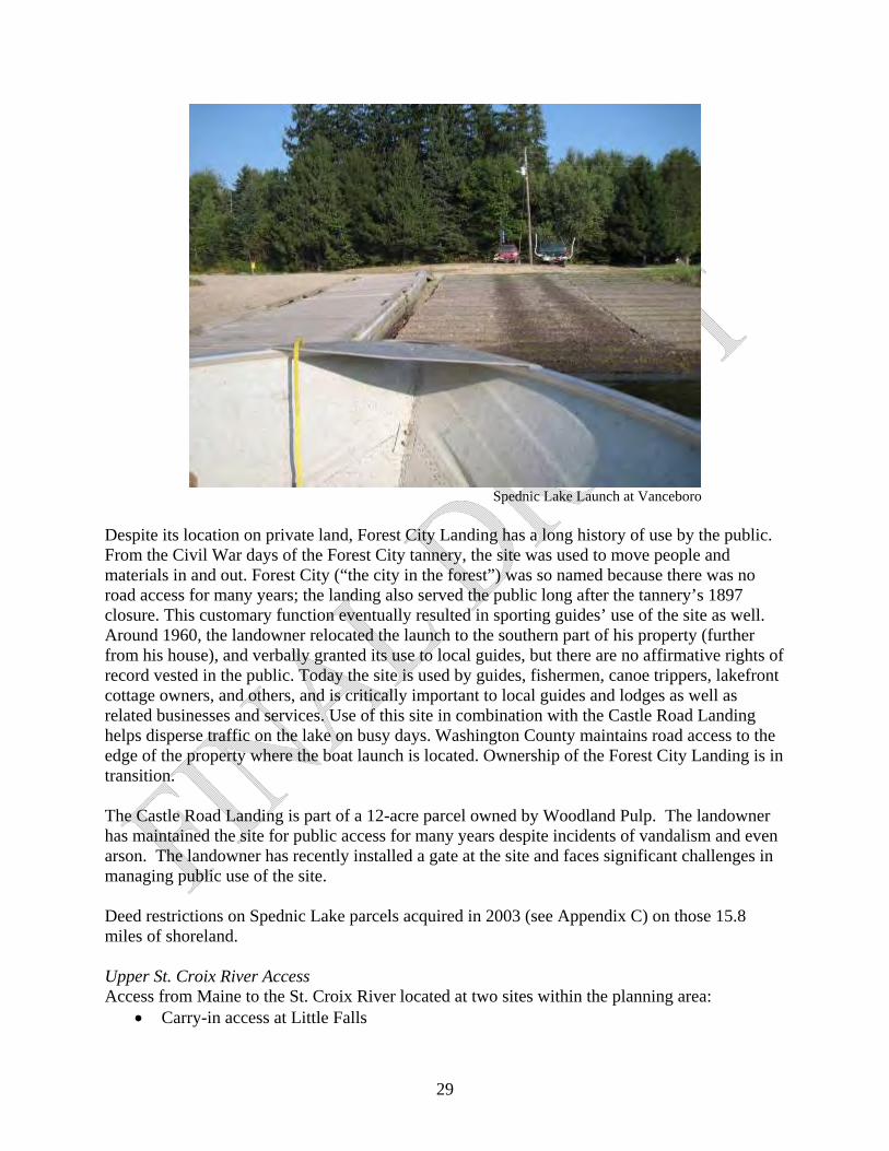
Spednic Lake Launch at Vanceboro
Despite its location on private land, Forest City Landing has a long history of use by the public. From the Civil War days of the Forest City tannery, the site was used to move people and materials in and out. Forest City (“the city in the forest”) was so named because there was no road access for many years; the landing also served the public long after the tannery’s 1897 closure. This customary function eventually resulted in sporting guides’ use of the site as well. Around 1960, the landowner relocated the launch to the southern part of his property (further from his house), and verbally granted its use to local guides, but there are no affirmative rights of record vested in the public. Today the site is used by guides, fishermen, canoe trippers, lakefront cottage owners, and others, and is critically important to local guides and lodges as well as related businesses and services. Use of this site in combination with the Castle Road Landing helps disperse traffic on the lake on busy days. Washington County maintains road access to the edge of the property where the boat launch is located. Ownership of the Forest City Landing is in transition. The Castle Road Landing is part of a 12-acre parcel owned by Woodland Pulp. The landowner has maintained the site for public access for many years despite incidents of vandalism and even arson. The landowner has recently installed a gate at the site and faces significant challenges in managing public use of the site. Deed restrictions on Spednic Lake parcels acquired in 2003 (see Appendix C) on those 15.8 miles of shoreland. Upper St. Croix River Access Access from Maine to the St. Croix River located at two sites within the planning area:
Carry-in access at Little Falls
29
A gravel trailerable launch at Loon Bay Landing and three sites near the planning area:
Carry-in access just below the Vanceboro Dam Carry-in access at the Fire Road in Vanceboro Carry-in access at Grand Falls dam, also known as Kellyland
Access to the Upper St. Croix River from Canada is provided at the village of St. Croix, at drive-in campsites below Scott Brook, Loon Bay, the Canoose River juncture and Grand Falls dam. Only the Little Falls and Loon Bay access points are publicly owned (as they are within the Bureau’s St. Croix ownership). Both these access sites have parking areas and vault toilets, and additionally, the Loon Bay site has a picnic shelter. Both sites have periodic problems with unauthorized camping in the parking lots. On holidays and some weekends, the Little Falls parking area is inadequate for the number of vehicles and canoe trailers. Loon Bay Landing has experienced significant erosion problems from stormwater runoff and occasional high river flows. Major repairs were funded in 2010 by the Recreational Trails Program and a Land for Maine’s Future Access Improvement grant. Both the Vanceboro and Grand Falls dam sites are owned by Woodland Pulp. The Vanceboro dam access site is part of the portage around the dam. This site presents safety concerns as a launch because of its proximity to the dam and its location above the Dam Down Rips. The Vanceboro Fire Road access is off a public road but lacks parking. It also has safety concerns as it launches right into Dam Down Rips. Both Vanceboro sites create conflicts with adjacent private landowners due to users blocking camp roads and private driveways. At the Grand Falls Dam, Woodland Pulp voluntarily provide public access and facilities including parking, a picnic area, a mowed lawn, a fishing dock, and a portable bathroom. Campsites All state authorized campsites are identified from the water by a small tent and name sign. This same signage is also used for all St. Croix Canadian campsites. Each site includes a picnic table, backcountry toilet, and fire ring. Fires are allowed in designated fire rings without special permits. Campsites are occasionally used by large groups and to date there have been no guidelines or limits set on group size.
30
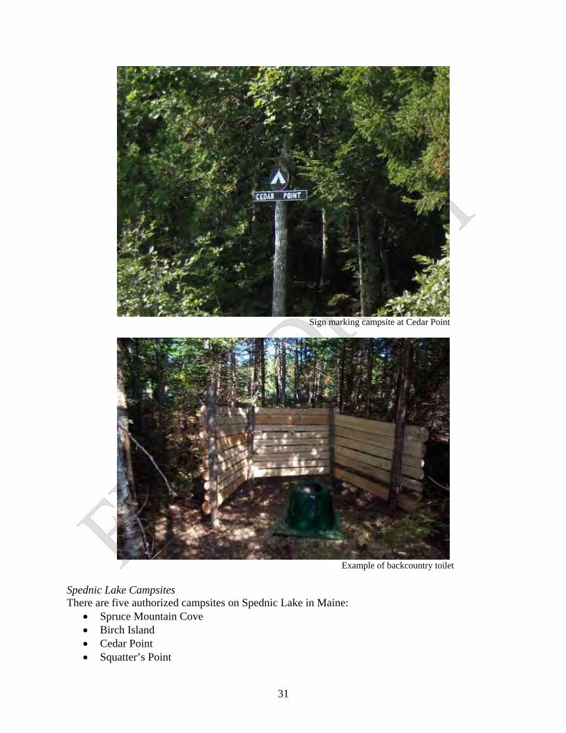
Sign marking campsite at Cedar Point
Example of backcountry toilet Spednic Lake Campsites There are five authorized campsites on Spednic Lake in Maine:
Spruce Mountain Cove Birch Island Cedar Point Squatter’s Point
31
The Narrows The Waterway Commission also maintains eight provincial water-access campsites and one provincial park on the Canadian side of Spednic Lake. Spednic Lake campsites are generally in good condition and are managed for water access only. Use guidelines are not currently posted at Spednic Lake campsites. The campsites at Cedar Point and The Narrows were just established in 2010. The Spruce Mountain Cove site has erosion problems and experiences occasionally land-based access by ATV. Unauthorized camping occasionally occurs on its west shore.
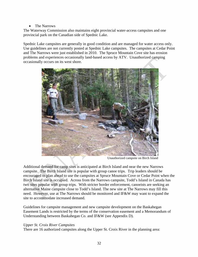
Unauthorized campsite on Birch Island
Additional demand for camp sites is anticipated at Birch Island and near the new Narrows campsite. The Birch Island site is popular with group canoe trips. Trip leaders should be encouraged to plan ahead to use the campsites at Spruce Mountain Cove or Cedar Point when the Birch Island site is occupied. Across from the Narrows campsite, Todd’s Island in Canada has two sites popular with group trips. With stricter border enforcement, canoeists are seeking an alternative Maine campsite close to Todd’s Island. The new site at The Narrows may fill this need. However, use at The Narrows should be monitored and IF&W may want to expand the site to accommodate increased demand. Guidelines for campsite management and new campsite development on the Baskahegan Easement Lands is restricted by the terms of the conservation easement and a Memorandum of Understanding between Baskahegan Co. and IF&W (see Appendix D). Upper St. Croix River Campsites There are 16 authorized campsites along the Upper St. Croix River in the planning area:
32
Porter’s Meadows Tunnel Rips The Cape Little Falls (2) Lower Little Falls Baby’s Grave Scott Brook Split Rock (2) Loon Bay (2) Annapurna Skutik Kendrick Rips Egg Point
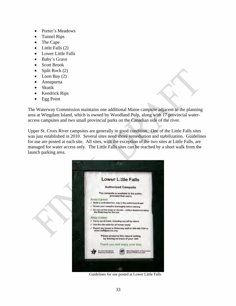
The Waterway Commission maintains one additional Maine campsite adjacent to the planning area at Wingdam Island, which is owned by Woodland Pulp, along with 17 provincial water-access campsites and two small provincial parks on the Canadian side of the river. Upper St. Croix River campsites are generally in good condition. One of the Little Falls sites was just established in 2010. Several sites need shore remediation and stabilization. Guidelines for use are posted at each site. All sites, with the exception of the two sites at Little Falls, are managed for water access only. The Little Falls sites can be reached by a short walk from the launch parking area.
Guidelines for use posted at Lower Little Falls
33
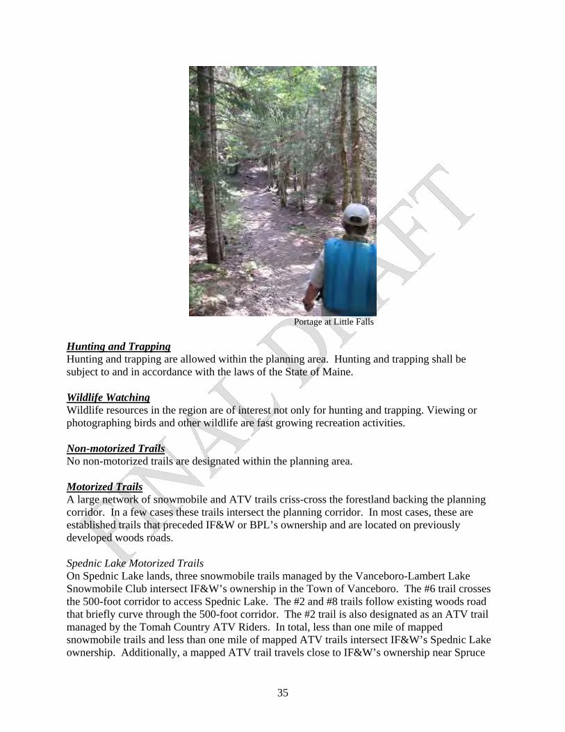
The Scott’s Brook campsite can be accessed by a logging road off the Lambert Lake Road. This site is not intended for vehicular access and, unlike the Lambert Lake Road, the access road was not identified as a Public Access Road as part of the Sunrise Tree Farm Public Access Easement. Unauthorized camping sometimes occurs along the Upper St. Croix River. In particular, there is one clear unauthorized site near the lower end of the Grassy Islands. On a 2010 visit, the site has lashed benches for viewing the sunset, a row of stacked firewood, and a fire pit wedged between two live trees. It appears that the site is used by locals and accessed by ATV. This site may be appropriate for meeting future increased demand for camping on the river. However, current demand and the proximity of the Loon Bay sites downstream do not justify the conversion of this site into an authorized public site at this time. Lunch Sites In addition to the five campsites on Spednic Lake, there are several additional lunch sites maintained by fishing guides out of Forest City. These sites are not marked from the water but their locations are mapped by the Forest City Guides Association and IF&W. Consisting of a picnic table and fire pit, these sites are available to the public for daytime use. The fire pits have not yet been authorized by the Maine Forest Service. These lunch sites are former lease sites that predate IF&W’s management. Currently no formal management agreement exists between IF&W and the Forest City Guides Association for these lunch sites. Portages There are 2 portages with the planning area on Spednic Lake located within the Booming Grounds Wildlife Management Area. There are two portages located within the planning area on the Upper St. Croix River—at Little Falls at Canoose Rips. Both river portage trails need improvements. A portage linking Spednic Lake and the Upper St. Croix River is located outside this management planning area on land owned by Woodland Pulp. The landowner has traditionally maintained the portage trail for pubic access.
34
Portage at Little Falls Hunting and Trapping Hunting and trapping are allowed within the planning area. Hunting and trapping shall be subject to and in accordance with the laws of the State of Maine. Wildlife Watching Wildlife resources in the region are of interest not only for hunting and trapping. Viewing or photographing birds and other wildlife are fast growing recreation activities. Non-motorized Trails No non-motorized trails are designated within the planning area. Motorized Trails A large network of snowmobile and ATV trails criss-cross the forestland backing the planning corridor. In a few cases these trails intersect the planning corridor. In most cases, these are established trails that preceded IF&W or BPL’s ownership and are located on previously developed woods roads. Spednic Lake Motorized Trails On Spednic Lake lands, three snowmobile trails managed by the Vanceboro-Lambert Lake Snowmobile Club intersect IF&W’s ownership in the Town of Vanceboro. The #6 trail crosses the 500-foot corridor to access Spednic Lake. The #2 and #8 trails follow existing woods road that briefly curve through the 500-foot corridor. The #2 trail is also designated as an ATV trail managed by the Tomah Country ATV Riders. In total, less than one mile of mapped snowmobile trails and less than one mile of mapped ATV trails intersect IF&W’s Spednic Lake ownership. Additionally, a mapped ATV trail travels close to IF&W’s ownership near Spruce
35
Mountain Cove in Forest Twp and it appears that some traffic spills into the corridor and to the Spruce Mountain Cove campsite. Upper St. Croix River Motorized Trails On the Upper St. Croix River lands, four snowmobile trails managed by the Vanceboro-Lambert Lake Snowmobile Club and one ATV trail managed by the Tomah County Riders intersect BPL’s ownership in the Town of Vanceboro, Lambert Lake Twp and Dyer Twp. In total, less than 2.5 miles of snowmobile trails and less than 2 miles of ATV trails intersect BPL’s Upper St. Croix River ownership. Recreation Information and Education No information on the Spednic Lake/Upper St. Croix River is currently available through IF&W or BPL websites or publications. The Waterway Commission sells a printed St. Croix recreation map and provides recreation information through its website and other means. Signage in the planning area includes campsite identification markers and basic guidelines posted at the Upper St. Croix River campsites. Recreation Use Survey The last recreation use survey was carried out by the Waterway Commission on the St. Croix River in 1991. Recreation Resource Management Issues and Recommendations:
Management Issue Management Recommendation Border Enforcement: Increased U.S. enforcement has discontinued the longstanding practice of recreationists using the St. Croix International Waterway having unencumbered access to campsites in both Maine and New Brunswick.
IF&W and BPL should continue to work with U.S. Customs and Border Protection to explore solutions to border enforcement challenges.
Border Enforcement: There is currently no Canadian permitting process that allows recreationists to land on the Canadian side of the St. Croix except at formal road entry points, preventing use of both Maine and New Brunswick campsites.
IF&W and BPL should reach out to the Canada Border Services Agency (CBSA) to explore establishing a counterpart to the U.S. I-68 Canadian Border Boating (I-68) Program for St. Croix users. Perhaps the model used on the Boundary Water Canoe Area on the Minnesota and Ontario border, the CANPASS Remote Area Border Crossing permit system, could be applied to the St. Croix.
Spednic Lake Water Access: Public access is not permanently secured north of the Vanceboro launch. Guaranteed public access to the upper end of Spednic Lake is critical to the lake’s backcountry recreational use and to the sporting guides who maintain the area’s traditional local economy.
BPL and IF&W should work with landowners, WWLT, and other interests to secure permanent public access to the Forest City Landing and the Castle Road Landing with the goal maintaining both sites as a primitive gravel ramps.
Upper St. Croix River Water Access: Public BPL should pursue safe and permanent public
36
access is not permanently secured at the upper or lower ends of the upper river. The lack of guaranteed access at these two points is a critical recreation issue as they represent the beginning and end of the traditional St. Croix River trip.
access to the river at Vanceboro and Grand Falls Flowage. BPL should also work with landowners to formalize long-term public access to the portage route around the Vanceboro dam.
Upper St. Croix River Water Access: The parking area for the Little Falls launch and Loon Bay Landing are sometimes used for car camping or trailer camping.
BPL should enforce policy prohibiting camping in parking areas and clearly indicate authorized camping areas nearby.
Parking: Parking demand can exceed capacity at Little Falls.
This problem can be partially alleviated by enforcing no camping policy in the Little Falls parking area. Additionally, BPL should consider developing additional parking at Little Falls to meet excess demand.
Campsites: Group size limits have not been set for campsites.
IF&W and BPL should establish group size limits of 12. Larger groups may be accommodated at designated sites by special permission.
Campsites: Consistent recreational signage guidelines have not been developed for the state's lake and river sites. At present, St. Croix BPL sites and the Canadian sites have similar signage.
Campsites on Spednic Lake and the Upper St. Croix River should continue to be marked with uniform, low-impact, site entrance signage. BPL should continue to use uniform low-impact user signage at campsites to encourage appropriate public use. IF&W should adopt similar signage, for uniformity. The number of signs should be kept to a minimum and be designed for minimal visual impact.
Unauthorized Camping known to occur on Spednic Lake at Birch Island, on the St. Croix River by the Grassy Islands and at other locations. Unauthorized campsites fragment the St. Croix’s semi-wilderness character, create fire hazards and degrade shoreland areas through tree removal, shore erosion and left-behind waste.
IF&W and BPL should post unauthorized sites with “no camping signs” which cannot be seen from the water so not to draw unwanted attention. Public information on authorized campsites and camping rules should be made more widely available. Unauthorized sites should be discouraged through enforcement and by dismantling fire rings and naturalizing impacted sites.
Future campsite development: The vision for the St. Croix International Waterway is for a backcountry, semi-wilderness experience. There is concern that the addition of new campsites will degrade this experience. However, use is also anticipated to grow and competition may increase for existing sites.
IF&W and BPL should give primacy to maintaining the St. Croix’s traditional backcountry experience over meeting increased demand. New campsite development should be limited, determined to have a minimal impact on the backcountry experience, and justified by documented increases in demand. Preference should be given to expanding
37
current sites rather than developing new sites. A second site at The Narrows on Spednic Lake is the only identified potential expansion at this time. Employ more active management when needed to limit use to the desired level for maintaining the remote backcountry experience.
Spednic Lake Lunch Sites: There is no formal management regarding guide lunch sites on Spednic Lake.
IF&W should work with the Forest City Guides Association to develop a formal MOU for use of the Spednic Lake lunch sites.
Spednic Lake Lunch Sites: The fire pits have not yet been authorized by the Maine Forest Service.
IF&W should work with the Forest City Guides Association to ensure all lunch site fire pits meet Maine Forest Service guidelines and receive formal authorization.
Spednic Lake Lunch Sites: Unauthorized overnight use of the lunch sites occurs occasionally.
IF&W should work with the Forest City Guides Association to monitor unauthorized overnight use at Spednic Lake lunch sites. At this time, signage is not deemed necessary to discourage unauthorized camping at Spednic Lake lunch sites. If overnight use should begin to increase, appropriate signage may be warranted.
Spednic Lake Lunch Sites: Although intended primarily for guide use, Spednic Lake lunch sites are open to public use. There is currently minimal overlap between local guides and public users at these sites, but conflicts may increase.
If conflicts should increase over time, IF&W should review its lunch site MOU to consider leasing these sites exclusively for guide use.
Upper St. Croix River Portages: Portage trail improvements are needed.
BPL should improve portage trails at Little Falls and Canoose Rips.
Spednic Lake Motorized trails: IF&W should authorize established motorized trail segments that follow existing woods roads and do not conflict with the primary management goal of maintaining a quiet backcountry wilderness experience along the lake. IF&W should work with the Vanceboro-Lambert Lake Snowmobile Club to investigate the location of the #6 trail in Vanceboro and determine whether it follows existing roads and whether alternative trails provide sufficient access to Spednic Lake in Vanceboro. IF&W should work with the Wagner Forest Management and the Bureau’s Off-road Vehicle Division to investigate the location of ATV trails near Spruce Mountain Cove and
38
39
explore options to prevent unauthorized access to the Spruce Mountain Cove campsite.
Upper St. Croix River Motorized trails: BPL should authorize established motorized trail segments that follow existing roads and do not conflict with primary management goal of maintaining a backcountry wilderness experience along the lake. BPL, through its Off-road Vehicles division, should work with the Vanceboro-Lambert Lake Snowmobile Club and Tomah Country ATV Riders to monitor unauthorized use within the planning corridor.
Recreation Information and Education: IF&W and BPL do not currently provide public information on recreation facilities or user rules for Spednic Lake or the Upper St. Croix River lands.
IF&W and BPL should work to provide public information on recreational facilities and user rules through BPL’s website, printed materials and kiosks at access points.
Recreation Use Survey: The last recreation use survey was conducted on the river in 1991. Additional use information would enhance the ability of the management entities to identify existing and emerging needs and issues.
IF&W and BPL should prioritize and support an updated recreation use survey to provide accurate information on summer use numbers and characteristics to assist with long-range planning. BPL should also gather winter use information through coordination with local snowmobile clubs.
Recreation Use Conflicts: Inappropriate conduct occurs on the river, particularly with prime water levels or holiday weekends.
IF&W and BPL, themselves and through agreements with other agencies, should periodically patrol the planning area to discourage user conduct that negatively affects public safety, the environment and the rights of users to quiet enjoyment of the resource.
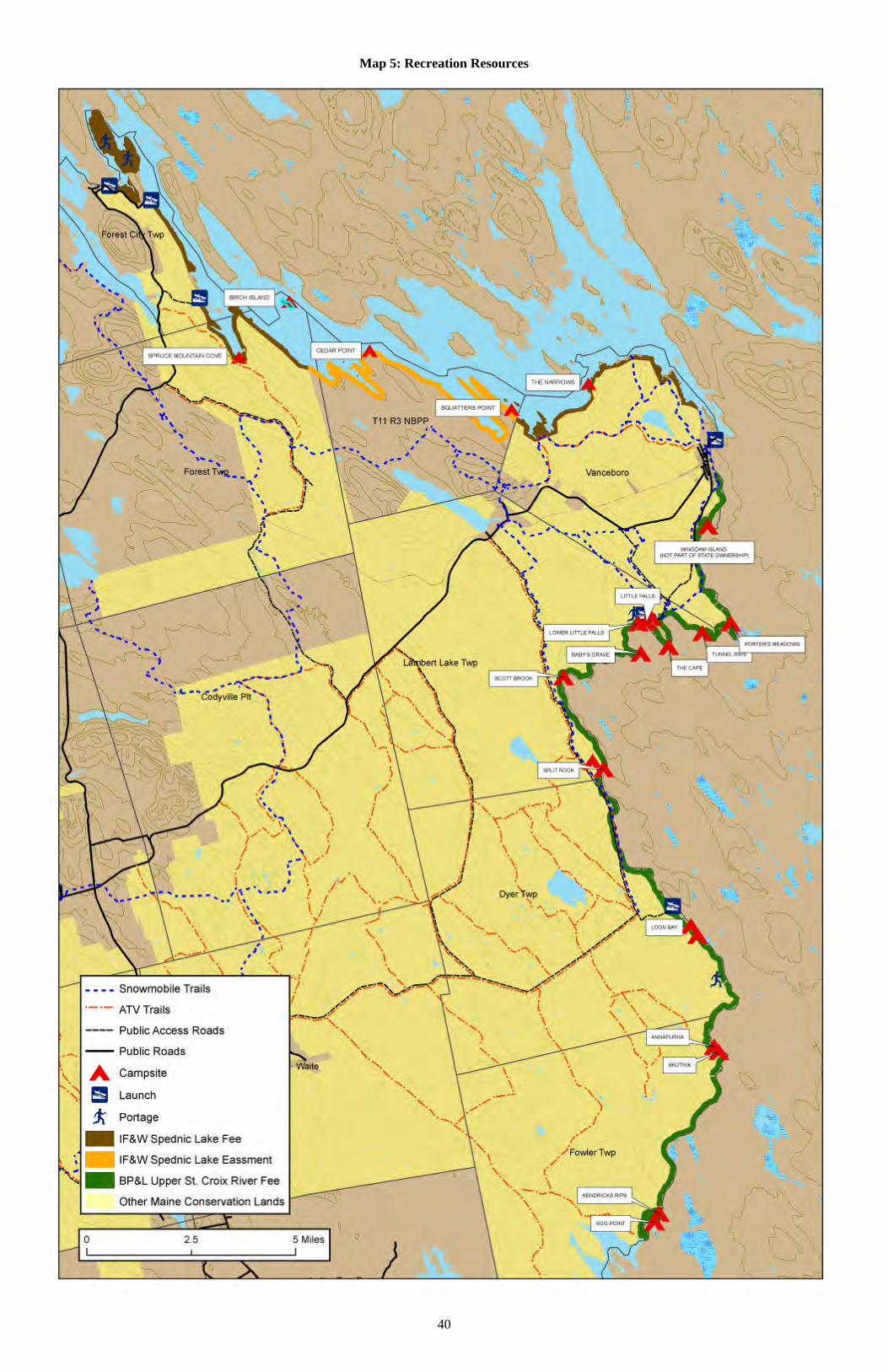
40
Map 5: Recreation Resources
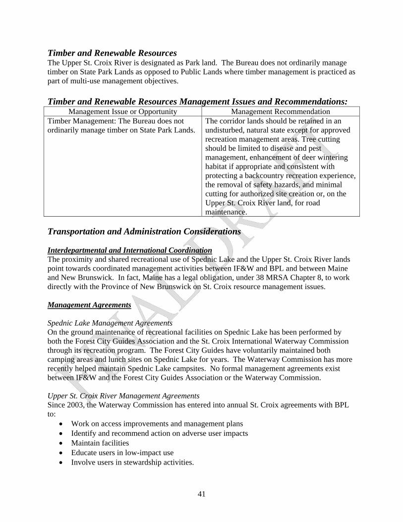
Timber and Renewable Resources The Upper St. Croix River is designated as Park land. The Bureau does not ordinarily manage timber on State Park Lands as opposed to Public Lands where timber management is practiced as part of multi-use management objectives. Timber and Renewable Resources Management Issues and Recommendations:
Management Issue or Opportunity Management Recommendation Timber Management: The Bureau does not ordinarily manage timber on State Park Lands.
The corridor lands should be retained in an undisturbed, natural state except for approved recreation management areas. Tree cutting should be limited to disease and pest management, enhancement of deer wintering habitat if appropriate and consistent with protecting a backcountry recreation experience, the removal of safety hazards, and minimal cutting for authorized site creation or, on the Upper St. Croix River land, for road maintenance.
Transportation and Administration Considerations Interdepartmental and International Coordination The proximity and shared recreational use of Spednic Lake and the Upper St. Croix River lands point towards coordinated management activities between IF&W and BPL and between Maine and New Brunswick. In fact, Maine has a legal obligation, under 38 MRSA Chapter 8, to work directly with the Province of New Brunswick on St. Croix resource management issues. Management Agreements Spednic Lake Management Agreements On the ground maintenance of recreational facilities on Spednic Lake has been performed by both the Forest City Guides Association and the St. Croix International Waterway Commission through its recreation program. The Forest City Guides have voluntarily maintained both camping areas and lunch sites on Spednic Lake for years. The Waterway Commission has more recently helped maintain Spednic Lake campsites. No formal management agreements exist between IF&W and the Forest City Guides Association or the Waterway Commission. Upper St. Croix River Management Agreements Since 2003, the Waterway Commission has entered into annual St. Croix agreements with BPL to:
Work on access improvements and management plans Identify and recommend action on adverse user impacts Maintain facilities Educate users in low-impact use Involve users in stewardship activities.
41
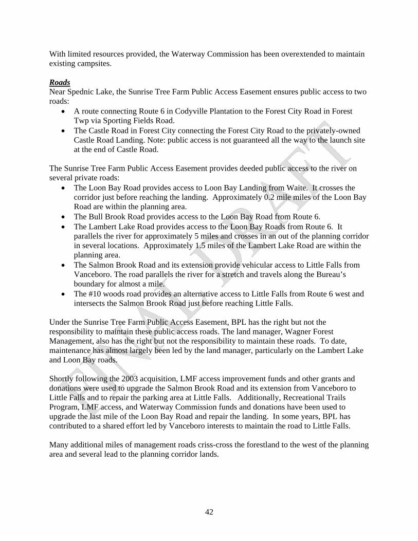
42
With limited resources provided, the Waterway Commission has been overextended to maintain existing campsites. Roads Near Spednic Lake, the Sunrise Tree Farm Public Access Easement ensures public access to two roads:
A route connecting Route 6 in Codyville Plantation to the Forest City Road in Forest Twp via Sporting Fields Road.
The Castle Road in Forest City connecting the Forest City Road to the privately-owned Castle Road Landing. Note: public access is not guaranteed all the way to the launch site at the end of Castle Road.
The Sunrise Tree Farm Public Access Easement provides deeded public access to the river on several private roads:
The Loon Bay Road provides access to Loon Bay Landing from Waite. It crosses the corridor just before reaching the landing. Approximately 0.2 mile miles of the Loon Bay Road are within the planning area.
The Bull Brook Road provides access to the Loon Bay Road from Route 6. The Lambert Lake Road provides access to the Loon Bay Roads from Route 6. It
parallels the river for approximately 5 miles and crosses in an out of the planning corridor in several locations. Approximately 1.5 miles of the Lambert Lake Road are within the planning area.
The Salmon Brook Road and its extension provide vehicular access to Little Falls from Vanceboro. The road parallels the river for a stretch and travels along the Bureau’s boundary for almost a mile.
The #10 woods road provides an alternative access to Little Falls from Route 6 west and intersects the Salmon Brook Road just before reaching Little Falls.
Under the Sunrise Tree Farm Public Access Easement, BPL has the right but not the responsibility to maintain these public access roads. The land manager, Wagner Forest Management, also has the right but not the responsibility to maintain these roads. To date, maintenance has almost largely been led by the land manager, particularly on the Lambert Lake and Loon Bay roads. Shortly following the 2003 acquisition, LMF access improvement funds and other grants and donations were used to upgrade the Salmon Brook Road and its extension from Vanceboro to Little Falls and to repair the parking area at Little Falls. Additionally, Recreational Trails Program, LMF access, and Waterway Commission funds and donations have been used to upgrade the last mile of the Loon Bay Road and repair the landing. In some years, BPL has contributed to a shared effort led by Vanceboro interests to maintain the road to Little Falls. Many additional miles of management roads criss-cross the forestland to the west of the planning area and several lead to the planning corridor lands.

43
Map 6: Transportation Resources
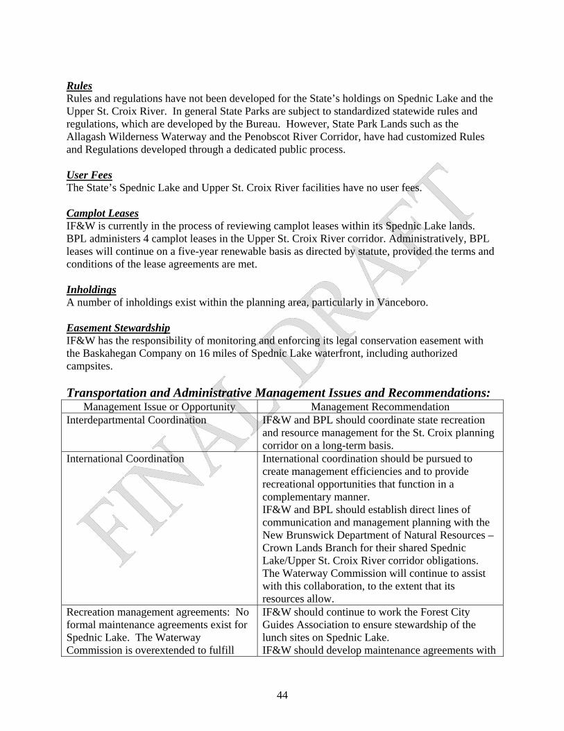
Rules Rules and regulations have not been developed for the State’s holdings on Spednic Lake and the Upper St. Croix River. In general State Parks are subject to standardized statewide rules and regulations, which are developed by the Bureau. However, State Park Lands such as the Allagash Wilderness Waterway and the Penobscot River Corridor, have had customized Rules and Regulations developed through a dedicated public process. User Fees The State’s Spednic Lake and Upper St. Croix River facilities have no user fees. Camplot Leases IF&W is currently in the process of reviewing camplot leases within its Spednic Lake lands. BPL administers 4 camplot leases in the Upper St. Croix River corridor. Administratively, BPL leases will continue on a five-year renewable basis as directed by statute, provided the terms and conditions of the lease agreements are met. Inholdings A number of inholdings exist within the planning area, particularly in Vanceboro. Easement Stewardship IF&W has the responsibility of monitoring and enforcing its legal conservation easement with the Baskahegan Company on 16 miles of Spednic Lake waterfront, including authorized campsites. Transportation and Administrative Management Issues and Recommendations:
Management Issue or Opportunity Management Recommendation Interdepartmental Coordination IF&W and BPL should coordinate state recreation
and resource management for the St. Croix planning corridor on a long-term basis.
International Coordination International coordination should be pursued to create management efficiencies and to provide recreational opportunities that function in a complementary manner. IF&W and BPL should establish direct lines of communication and management planning with the New Brunswick Department of Natural Resources – Crown Lands Branch for their shared Spednic Lake/Upper St. Croix River corridor obligations. The Waterway Commission will continue to assist with this collaboration, to the extent that its resources allow.
Recreation management agreements: No formal maintenance agreements exist for Spednic Lake. The Waterway Commission is overextended to fulfill
IF&W should continue to work the Forest City Guides Association to ensure stewardship of the lunch sites on Spednic Lake. IF&W should develop maintenance agreements with
44
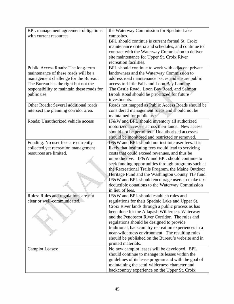
BPL management agreement obligations with current resources.
the Waterway Commission for Spednic Lake campsites. BPL should continue is current formal St. Croix maintenance criteria and schedules, and continue to contract with the Waterway Commission to deliver site maintenance for Upper St. Croix River recreation facilities.
Public Access Roads: The long-term maintenance of these roads will be a management challenge for the Bureau. The Bureau has the right but not the responsibility to maintain these roads for public use.
BPL should continue to work with adjacent private landowners and the Waterway Commission to address road maintenance issues and ensure public access to Little Falls and Loon Bay Landing. The Castle Road, Loon Bay Road, and Salmon Brook Road should be prioritized for future investments.
Other Roads: Several additional roads intersect the planning corridor area.
Roads not mapped as Public Access Roads should be considered management roads and should not be maintained for public use.
Roads: Unauthorized vehicle access IF&W and BPL should inventory all authorized motorized accesses across their lands. New access should not be permitted. Unauthorized accesses should be monitored and restricted or removed.
Funding: No user fees are currently collected yet recreation management resources are limited.
IF&W and BPL should not institute user fees. It is likely that instituting fees would lead to servicing costs that could exceed revenues, and thus be unproductive. IF&W and BPL should continue to seek funding opportunities through programs such at the Recreational Trails Program, the Maine Outdoor Heritage Fund and the Washington County TIF fund. IF&W and BPL should encourage users to make tax-deductible donations to the Waterway Commission in lieu of fees.
Rules: Rules and regulations are not clear or well-communicated.
IF&W and BPL should establish rules and regulations for their Spednic Lake and Upper St. Croix River lands through a public process as has been done for the Allagash Wilderness Waterway and the Penobscot River Corridor. The rules and regulations should be designed to provide traditional, backcountry recreation experiences in a near-wilderness environment. The resulting rules should be published on the Bureau’s website and in printed materials.
Camplot Leases: No new camplot leases will be developed. BPL should continue to manage its leases within the guidelines of its lease program and with the goal of maintaining the semi-wilderness character and backcountry experience on the Upper St. Croix
45

River corridor. Easement Stewardship: IF&W should monitor the Baskahegan easement
lands annually.
46
VI. Monitoring and Evaluation Monitoring and evaluation are needed to track progress in achieving the management goals and objectives for the Plan area and the effectiveness of particular approaches to resource management. Monitoring and evaluation will be conducted on wildlife, ecological, timber, and recreational management in relation to the expressed goals and intentions of this management plan. IF&W and BPL will work to develop an action plan for implementing and monitoring the management recommendations in this Plan. This will include an assignment of priorities and will, along with help shape budgets and maintenance agreements on an annual basis. IF&W and BPL will track progress in implementing the recommendations and make adjustments to the priorities as needed. Recreation Data on recreational use is helpful in allocating staff and monetary resources for management of the properties and in determining the public’s response to the opportunities being provided. In addition to gathering data on use, IF&W and BPL will monitor public use to determine:
(1) whether improvements to existing facilities or additional facilities might be needed and compatible with general objectives;
(2) whether additional measures are needed to ensure that recreational users have a high quality experience;
(3) whether use is adversely affecting sensitive natural resources or the ecology of the area; (4) whether measures are needed to address safety issues; (5) whether changing recreational uses and demands present the need or opportunity for
adjustments to existing facilities and management; and (6) whether any changes are needed in the management of recreation in relation to other
management objectives, including protection or enhancement of wildlife habitat and forest management.
Wildlife IF&W and BPL routinely conducts a variety of species monitoring activities statewide. The following are monitoring activities that are ongoing or anticipated for plan area:
(1) BPL will work with IF&W to monitor and manage the habitat within Deer Wintering Areas; and
(2) BPL will work with IF&W to monitor changes in eagle nesting patterns.
Stewardship Endowment In 2008, a stewardship endowment fund was established by the New England Forestry Foundation and is managed by the Maine Community Foundation to help defray resource conservation and recreation management expenses for Spednic Lake and Upper St. Croix River lands held in fee or managed by IF&W, BPL or WWLT. In 2010, a Stewardship Endowment Fund Agreement was endorsed by BPL, IF&W, WWLT, and the Waterway Commission (see Appendix E). Under this agreement, IF&W and BPL agreed to
47

48
develop a recreational and resource management plan for the U.S. portion of the corridor to formulate a long-range vision for recreation and conservation management, and address issues arising from border enforcement. This planning effort is a result of that commitment and this Plan will provide guidance for the use of this Stewardship Fund.