Embed Size (px)
Citation preview
1
1
• Terminal Doppler Weather Radar Basics– FAA radar designed to cover only its associated airport– 2 operational modes – both 6 minutes in duration
• Monitor (VCP90) and Hazardous (VCP80)• Elevation angles are site dependent
– Occasional non-operational modes• Calibration• Others?
– Clutter filtering performed within 90 km and below approximately10 degrees elevation
SPG Build 3 Training Hotline Meteorologists
2
• TDWR Basics (continued)– Base data is relative to magnetic north and adjusted to true north
by the SPG– Spot blanking performed at some sites– SPG has no control over the TDWR RDA– C-band radar (5 cm wavelength)– 0.55 degree beam sampled every 1.0 degrees– Two VCPs, both are constructed from one long range scan
followed by multiple short range scans, including one repeat cut(similar to MPDA)
SPG Build 3 Training Hotline Meteorologists
2
3
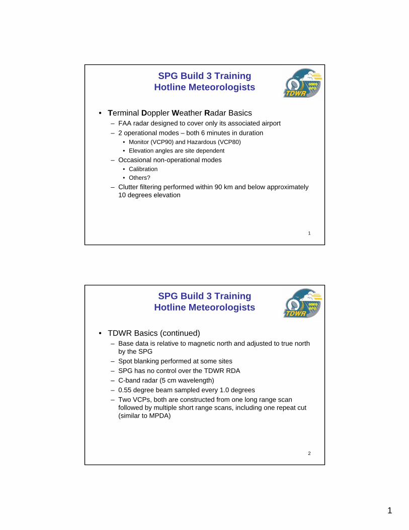
• Long Range Scan – 248 nmi* (460 km*)– Always the first elevation cut of a volume scan– Always at 0.6 degrees elevation angle– Reflectivity data only
• Reflectivity data range is -30 to +80 dBZ– Low PRF– 150 meter range resolution close to radar, 300 meter range
resolution beyond 135 km• NOTE: SPG combines the 150 meter data into 300 meter data by
averaging the returned power of every two bins.– *LR reflectivity product display range is reduced to 225 nmi (416 km)– Data from this long range scan is used by TDWR in all subsequent
short range scans of the volume for range ambiguity mitigation.• PRF selection• Setting of data quality flags
SPG Build 3 Training Hotline Meteorologists
4
• Short Range Scans – 48 nmi (90 km)– Used for all but the first elevation cut of a volume scan– Elevation angles vary by TDWR site– Reflectivity, Velocity and Spectrum Width
• Reflectivity data range is -30 to +80 dBZ• Velocity data range is +/- 156 knots• Spectrum width data range is 0 to 10 m/sec
– High PRF– 150 meter range resolution– Data truncated at 70,000 feet above radar level
• Applicable above approximately 7 degrees elevation
SPG Build 3 Training Hotline Meteorologists
3
5
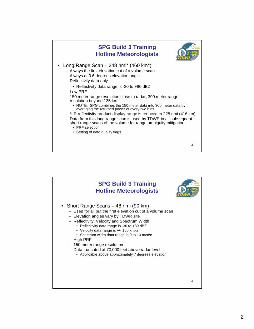
• VCP90 – Monitor Mode– Used when no significant weather is near the associated airport– 6-minutes to complete– Maximum elevation angle is 60 degrees at all sites– Minimum elevation angle varies by site with some as low as 0.1
degree– Most like a WSR-88D scanning strategy– After the 0.6 degree long range scan, 15 short range elevation
scans are performed in sequence, low to high
SPG Build 3 Training Hotline Meteorologists
6
• VCP80 – Hazardous Mode– Used when significant weather is near the associated airport– 6-minutes to complete– Maximum elevation angle varies by site from 60 degrees at
Orlando to as low as 20.1 degrees at several sites– Minimum elevation angle varies by site with some as low as 0.1
degree– Most unlike a WSR-88D scanning strategy– After the 0.6 degree long range scan, 21 short range elevation
scans are performed in a complex sequence:• lowest elevation scanned one per minute• third scan is performed only once• all remaining scans are performed every 3 minutes
– 3-minute “mini-volume” technique by SPG for some algorithms
SPG Build 3 Training Hotline Meteorologists
4
7
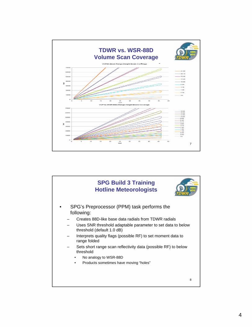
TDWR vs. WSR-88DVolume Scan Coverage
8
SPG Build 3 Training Hotline Meteorologists
• SPG’s Preprocessor (PPM) task performs the following:
– Creates 88D-like base data radials from TDWR radials– Uses SNR threshold adaptable parameter to set data to below
threshold (default 1.0 dB)– Interprets quality flags (possible RF) to set moment data to
range folded– Sets short range scan reflectivity data (possible RF) to below
threshold• No analogy to WSR-88D• Products sometimes have moving “holes”

5
9
• SPG’s Preprocessor (PPM) task functionality (continued):– Velocity is quantized from 0.25 m/s precision to 0.5 or 1.0 m/s by
PPM, depending on adaptation data setting– Dealiased velocity data and TDWR Scans 2 & 3 merged based
on adaptation data setting as follows:• “TDWR using cut 3”
– Reflectivity from cut 2 and TDWR dealiased velocity from cut 3• “SPG using cut 3” (default)
– Reflectivity from cut 2 and aliased velocity from cut 3 which is then dealiased by the SPG using the WSR-88D dealiasing algorithm
• “SPG using cut 2”– Reflectivity from cut 2 and aliased velocity from cut 2 which is them
dealiased by the SPG using the WSR-88D dealiasing algorithm– PRF of scan 3 is consistent with other surface scans.
• Use of scan 2 can show data where other scans may be range folded, but time loops may appear jumpy
SPG Build 3 Training Hotline Meteorologists
10
• SPG’s Preprocessor (PPM) task functionality (continued):– Sector Blanking
• Sets status to enabled if TDWR base data reports it • Resets it to disabled if base data does not report it during a compete
volume scan • Like RPG, SPG products report spot blanking if enabled
– Forms RDA Status Message to emulate WSR-88D• Becomes TDWR Unit Status display on AWIPS• VCP change• Calibration Mode
SPG Build 3 Training Hotline Meteorologists
6
11
SPG Build 3 Training Hotline Meteorologists
• SPG’s Preprocessor (PPM) task functionality (continued):– Fills missing and “fat” radials caused by:
• Missing: UDP packet loss– Poor quality FAA/WFO communication– SPG hardware glitch– Unusual SPG activity (e.g., base data compress & burn DVD)
• Fat: Large delta azimuth, without packet loss– Cases
• Single radials or sectors within an elevation. • Crossed elevation: PPM forms End-of-Elevation and Beg-of-Elevation• Skipped elevation: Lets downstream task PBD abort the volume scan
– Mitigation to minimize volume scan aborts• PPM formed radial is blank except for bins at max range• Informs user of missing data and to distinguish from typical radar data
problems (strobes, blockage, spot blanking, glitches)
12
• Build 3 SPG Base Products– Reflectivity
• 16 data level, 300 meter resolution, 225 nmi range• 256 data level, 300 meter resolution, 225 nmi range• 16 data level, 150 meter resolution, 48 nmi range• 256 data level, 150 meter resolution, 48 nmi range
– Velocity• 16 data level, 150 meter resolution, 48 nmi range• 256 data level, 150 meter resolution, 48 nmi range
– Spectrum Width• 8 data level, 150 meter resolution, 48 nmi range
SPG Build 3 Training Hotline Meteorologists
7
13
• Build 3 SPG Derived Products– Composite Reflectivity– VIL– Echo Tops– CR, VIL and ET
• All products formats identical to WSR-88D versions except data range is 48 nmi
• VCP90: 6-minute updates; includes all elevations• VCP80: 3-minute updates; includes all elevations in each mini-volume,
reusing the first and third scans for the second mini-volume
SPG Build 3 Training Hotline Meteorologists
14
• Build 3 SPG Derived Products (continued)– Storm Tracking Information– Hail Index– Mesocyclone Detection– Tornadic Vortex Signature– STI, HI, MD, DMD and TVS
• All product formats identical to WSR-88D versions except range is 48 nmi
• VCP90: 6-minute updates; includes elevations below configurable elevation number
• VCP80: 3-minute updates; includes elevations below configurable elevation number in each mini-volume, reusing the third scan for the second mini-volume
SPG Build 3 Training Hotline Meteorologists

8
15
• Build 3 SPG Products (continued)– Velocity Azimuth Display– VAD Wind Profile– VAD, VWP
• All product formats identical to WSR-88D versions except maximum range is 48 nmi
• VCP90: 6-minute updates; includes all elevations• VCP80: 6-minute updates; includes the last cut of each short range
angle
SPG Build 3 Training Hotline Meteorologists
16
• Build 3 SPG Derived Products (continued)– User Selectable Layer Reflectivity– ULR
• Product format identical to WSR-88D version except maximum range is 48 nmi
• VCP90: 6-minute updates; includes all elevations• VCP80: 6-minute updates; includes all elevations
SPG Build 3 Training Hotline Meteorologists
9
17
• Build 3 SPG Derived Products (continued)– One-Hour Precipitation– Three-Hour Precipitation– Storm Total Precipitation– User Selectable Precipitation– Hybrid Scan Reflectivity– Digital Precipitation Array– Supplemental Precipitation Data– OHP, THP, STP, USP, DHR, HSR, DPA, SPD
• All product formats are identical to WSR-88D versions• VCP90: 6-minute updates; includes only the first elevation• VCP80: 6-minute updates; includes only the first elevation• No REC due to heavy clutter filtering within 90 km by TDWR RDA• Data is power averaged from 300 meter to 1 km resolution• No blockage file used• Will use gage-bias if provided by AWIPS
SPG Build 3 Training Hotline Meteorologists
18
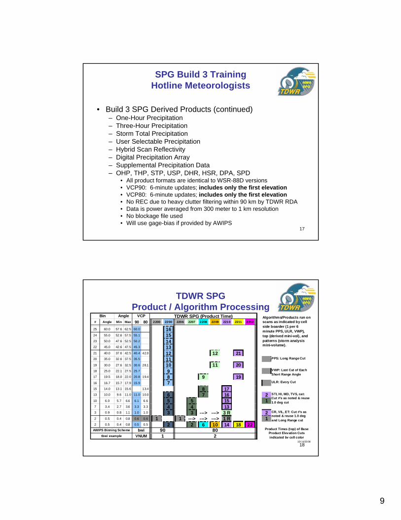
TDWR SPG Product / Algorithm Processing
# Angle Min Max 90 80 2200 2200 2206 2207 2208 2209 2210 2211 2212
25 60.0 57.6 62.5 60.0 1624 55.0 52.6 57.5 55.1 1523 50.0 47.6 52.5 50.2 1422 45.0 42.6 47.5 45.3 1321 40.0 37.6 42.5 40.4 42.0 12 12 2120 35.0 32.6 37.5 35.5 1119 30.0 27.6 32.5 30.6 28.1 10 11 2018 25.0 22.1 27.5 25.7 917 19.5 18.0 22.0 20.8 19.4 8 9 1916 16.7 15.7 17.9 15.9 715 14.0 13.1 15.6 13.4 8 1713 10.0 9.6 11.0 11.0 10.0 6 7 16 210 6.0 5.7 6.6 6.1 6.6 5 5 15 17 3.4 2.7 3.6 3.3 3.3 4 4 133 0.9 0.8 1.1 1.0 1.0 3 3 ---> ---> 3 R 22 0.5 0.4 0.8 0.6 0.6 1 1 ---> ---> ---> 1 R 12 0.5 0.4 0.8 0.5 0.5 2 2 6 10 14 18 22
PPS: Long Range Cut
STI, HI, MD, TVS, cat: Cut #'s as noted & reuse 1.0 deg cut
CR, VIL, ET: Cut #'s as noted & reuse 1.0 deg and Long Range cut
VWP: Last Cut of Each Short Range Angle
Product Times (top) of Base Product Elevation Cuts indicated by cell color
Angle VCP
10/ 14/2008
TDWR SPG (Product Time) Algorithms/Products run on scans as indicated by cell side boarder (1 per 6 minute PPS, ULR, VWP), top (derived mini-vol), and patterns (storm analysis mini-volume).
Bin
ULR: Every Cut
AWIPS Binning Scheme
tbwi examplebwi
VNUM 218090
10
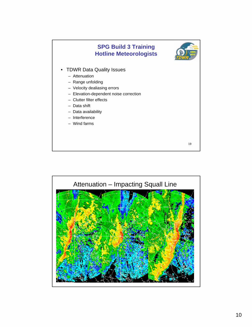
19
• TDWR Data Quality Issues– Attenuation– Range unfolding– Velocity dealiasing errors– Elevation-dependent noise correction– Clutter filter effects– Data shift– Data availability– Interference– Wind farms
SPG Build 3 Training Hotline Meteorologists
20
Attenuation – Impacting Squall Line
11
21
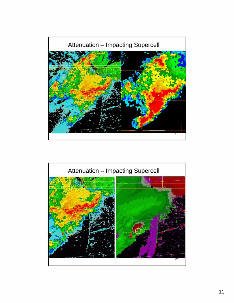
Attenuation – Impacting Supercell
22
Attenuation – Impacting Supercell
12
23
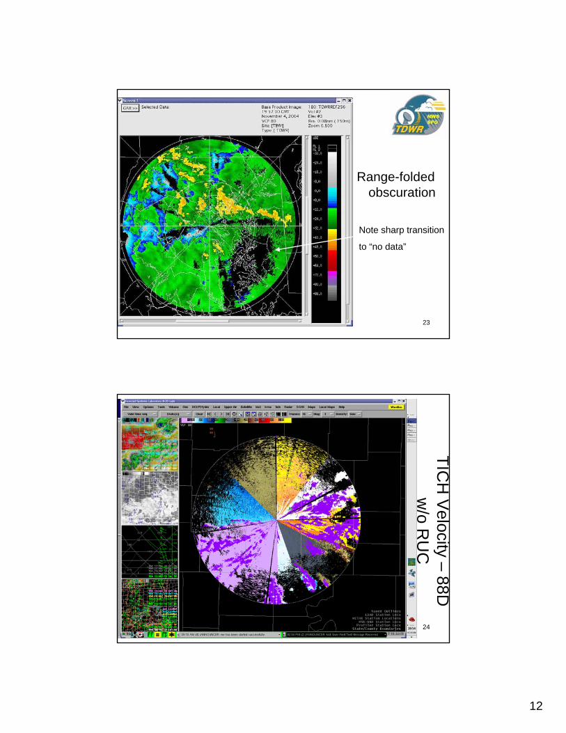
Range-folded obscuration
Note sharp transition
to “no data”
24
TICH
Velocity –
88D
w/o R
UC
13
25
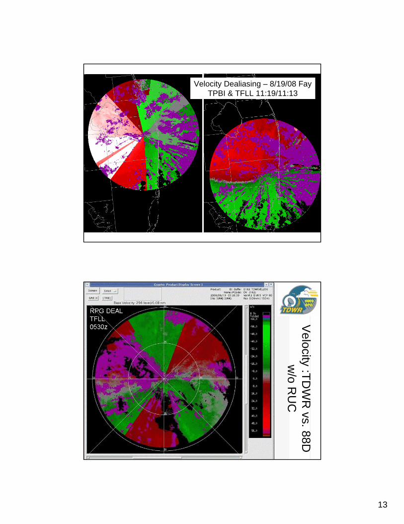
Velocity Dealiasing – 8/19/08 Fay TPBI & TFLL 11:19/11:13
26
Velocity :TD
WR
vs. 88D
w/o R
UC
14
27
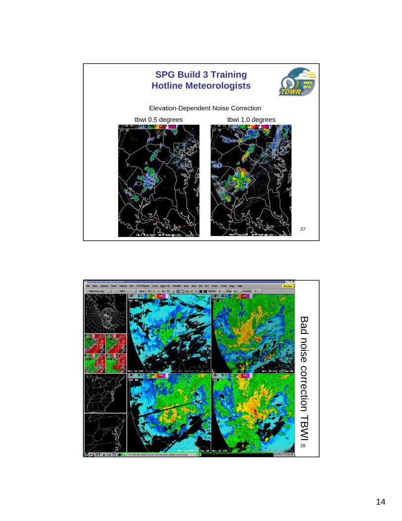
SPG Build 3 Training Hotline Meteorologists
tbwi 0.5 degrees tbwi 1.0 degrees
Elevation-Dependent Noise Correction
28
Bad noise correction TB
WI
15
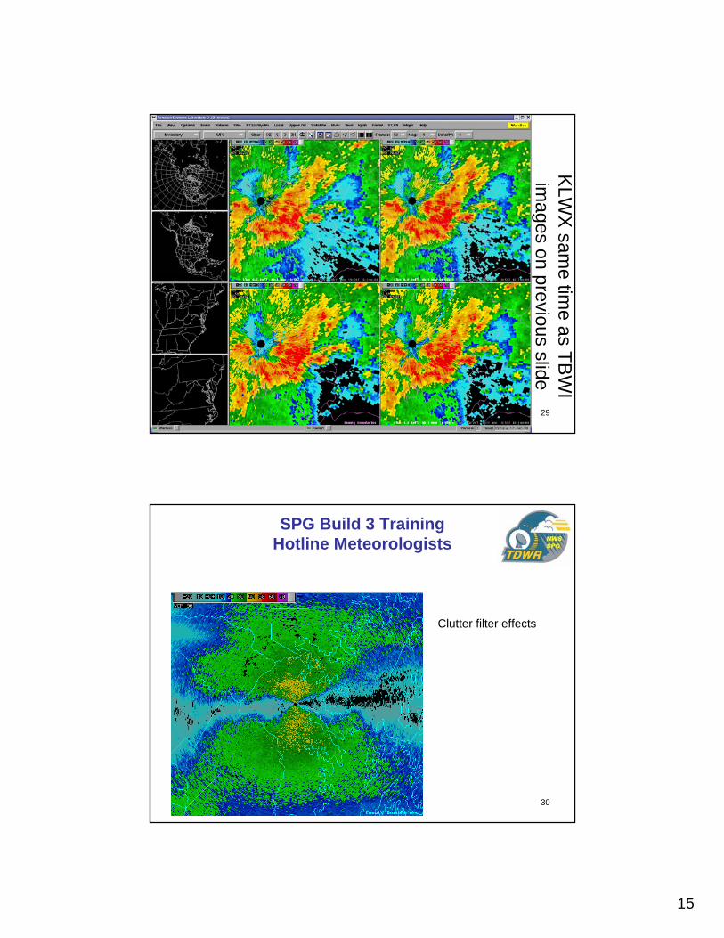
29
KLW
X sam
e time as TB
WI
images on previous slide
30
SPG Build 3 Training Hotline Meteorologists
Clutter filter effects
16
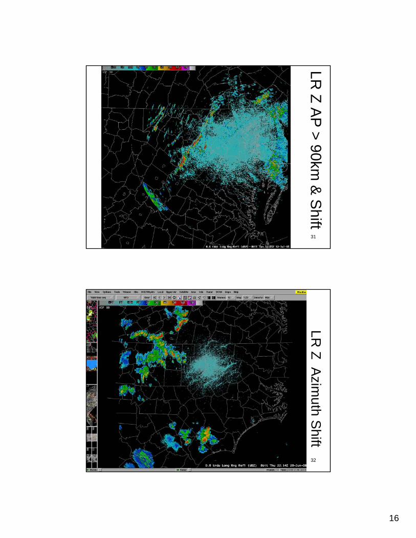
31
AP suppressed to 90 km
LR Z A
P > 90km
& S
hift
32
LR Z A
zimuth S
hift
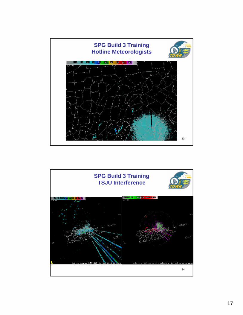
17
33
SPG Build 3 Training Hotline Meteorologists
34
SPG Build 3 Training TSJU Interference
18
35
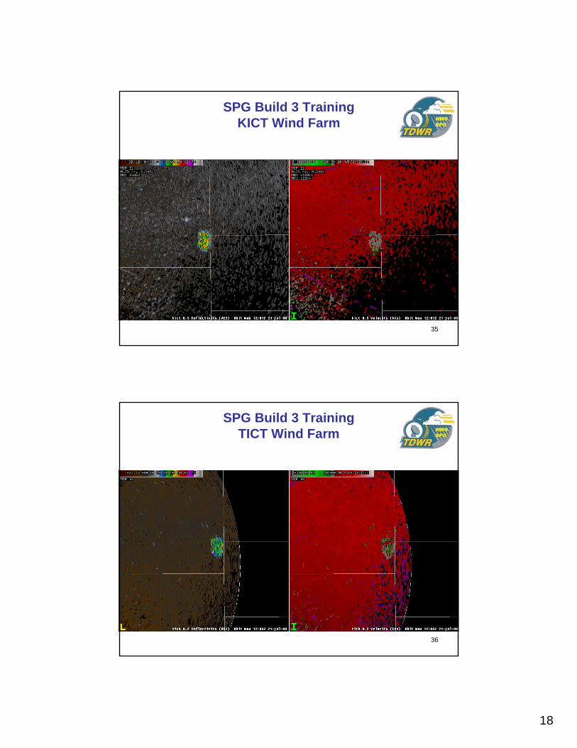
SPG Build 3 Training KICT Wind Farm
36
SPG Build 3 Training TICT Wind Farm
19
37
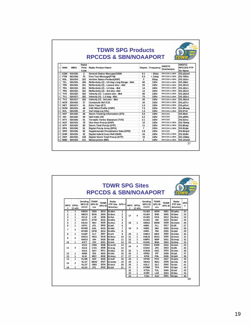
# NNN WMORadar Prod Code
Radar Product Name Kbytes Frequency NWSTG Distribution
NWSTG RPCCDS FTP Dir Name
1 GSM NXUS6i 2 General Status Message(GSM) 0.1 ~ 5/day RPCCDS & SBN DS.p2gsm2 FTM NOUS6i 75 Free Text Message(FTM) 0.3 < 1/day RPCCDS & SBN DS.75ftm3 RSL SDUS4i 152 Archive Status Product(ASP) 3 3/day RPCCDS & SBN DS.152rs4 TZL SDUS5i 186 Reflectivity (Z) - 0.6 deg Long Range - 8bit 80 10/hr RPCCDS & SBN DS.186zl5 TR0 SDUS5i 181 Reflectivity (Z) - Lowest elev - 4bit 25 10/hr RPCCDS & SBN DS.181r06 TR1 SDUS2i 181 Reflectivity (Z) - 1.0 deg - 4bit 14 10/hr RPCCDS & SBN DS.181r17 TR2 SDUS2i 181 Reflectivity (Z) - 3rd elev- 4bit 12 10/hr RPCCDS & SBN DS.181r28 TV0 SDUS5i 182 Velocity (V) - Lowest elev - 8bit 90 10/hr RPCCDS & SBN DS.182v09 TV1 SDUS7i 182 Velocity (V) - 1.0 deg - 8bit 70 10/hr RPCCDS & SBN DS.182v1
10 TV2 SDUS7i 182 Velocity (V) - 3rd elev - 8bit 45 10/hr RPCCDS & SBN DS.182v211 NCR SDUS5i 37 Composite Ref (CZ) 20 10/hr RPCCDS & SBN DS.p37cr12 NET SDUS7i 41 Echo Tops (ET) 1.5 10/hr RPCCDS & SBN DS.p41et13 NVW SDUS3i 48 VAD Wind Profile (VWP) 7.5 10/hr RPCCDS & SBN DS.48vwp14 NVL SDUS5i 57 Vert Integ Liq (VIL) 1.3 10/hr RPCCDS & SBN DS.57vil15 NST SDUS6i 58 Storm Tracking Information (STI) 3.5 10/hr RPCCDS DS.58sti16 NHI SDUS6i 59 Hail Index (HI) 3.2 10/hr RPCCDS DS.p59hi17 NTV SDUS6i 61 Tornadic Vortex Signature (TVS) 2.1 10/hr RPCCDS DS.61tvs18 N1P SDUS3i 78 One Hour Precip (OHP) 10 10/hr RPCCDS & SBN DS.78ohp19 NTP SDUS5i 80 Storm Total Precip (STP) 11 10/hr RPCCDS & SBN DS.80stp20 DPA SDUS8i 81 Digital Precip Array (DPA) 7 10/hr RPCCDS & SBN DS.81dpr21 SPD SDUS6i 82 Supplemental Precipitation Data (SPD) 2.8 10/hr RPCCDS DS.82spd22 DHR SDUS5i 32 Digital Hybrid Scan Refl (DHR) 32 10/hr RPCCDS & SBN DS.32dhr23 DSP SDUS5i 138 Digital Storm Total Precip (STP) 15 10/hr RPCCDS & SBN DS.138dp24 NMD SDUS3i 141 Mesocyclone (MD) 2 10/hr RPCCDS & SBN DS.141md
TDWR SPG ProductsRPCCDS & SBN/NOAAPORT
38
TDWR SPG SitesRPCCDS & SBN/NOAAPORT
WFO #
SPGs @ wfo
Sending WFO ID CCCC
TDWR SPG ID
xxx
TDWR SPG ID
Radar FTP Site directory
SPG # WFO #
SPGs@ wfo
Sending WFO ID CCCC
TDWR SPG ID
xxx
TDWR SPG ID
Radar FTP Site directory
SPG #
1 1 KBOU DEN 3013 SI.tden 1 KLWX ADW 3001 SI.tadw 222 1 KBOX BOS 3004 SI.tbos 2 KLWX BWI 3005 SI.tbwi 233 1 KCLE LVE 3006 SI.tlve 3 KLWX DCA 3012 SI.tdca 244 1 KDTX DTW 3015 SI.tdtw 4 KLWX IAD 3019 SI.tiad 255 1 KEAX MCI 3025 SI.tmci 5 18 1 KMEG MEM 3028 SI.tmem 266 1 KFFC ATL 3002 SI.tatl 6 KMFL FLL 3017 SI.tfll 27
KFWD DAL 3010 SI.tdal 7 KMFL MIA 3029 SI.tmia 28KFWD DFW 3014 SI.tdfw 8 KMFL PBI 3035 SI.tpbi 29
8 1 KGSP CLT 3007 SI.tclt 9 20 1 KMKX MKE 3030 SI.tmke 30KHGX HOU 3018 SI.thou 10 21 1 KMLB MCO 3026 SI.tmco 31KHGX IAH 3020 SI.tiah 11 22 1 KMPX MSP 3031 SI.tmsp 32
10 1 KICT ICH 3021 SI.tich 12 23 1 KOHX BNA 3003 SI.tbna 33KILN CMH 3008 SI.tcmh 13 KOKX EWR 3016 SI.tewr 34KILN CVG 3009 SI.tcvg 14 KOKX JFK 3023 SI.tjfk 35KILN DAY 3011 SI.tday 15 25 1 KOUN OKC 3033 SI.tokc 36
12 1 KIND IDS 3022 SI.tids 16 26 1 KPBZ PIT 3038 SI.tpit 3713 1 KLIX MSY 3032 SI.tmsy 17 27 1 KPHI PHL 3036 SI.tphl 3814 1 KLMK SDF 3040 SI.tsdf 18 28 1 KPSR PHX 3037 SI.tphx 39
KLOT MDW 3027 SI.tmdw 19 29 1 KRAH RDU 3039 SI.trdu 40KLOT ORD 3034 SI.tord 20 30 1 KSLC SLC 3042 SI.tslc 41
16 1 KLSX STL 3043 SI.tstl 21 31 1 KTBW TPA 3044 SI.ttpa 4232 1 KTSA TUL 3045 SI.ttul 4333 1 KVEF LAS 3024 SI.tlas 4434 1 TJSJ SJU 3041 SI.tsju 45
24 2
17 4
19 3
11 3
15 2
7 2
9 2
20
39
SPGs@WFO #
Sending WFO ID CCCC
TDWR SPG ID
xxx
WMO header TTUSii
Product category
NNNRPCCDS SBN #
Product Name (* GSM sent upon mode change, FTM as operator issued, ASP is every 8 hours)
Product Code
Size Kbytes
Elevation (*varies)
Radar FTP product directory
Radar FTP Site directory
#
1 1 KBOU DEN NXUS6i GSM Y Y 1 General Status Message(GSM)* 2 0.1 0 DS.p2gsm SI.tadw 11 2 KBOX BOS NOUS6i FTM Y Y 2 Free Text Message(FTM)* 75 0.75 0 DS.75ftm SI.tatl 21 3 KCLE LVE SDUS4i RSL Y Y 3 Archive Status Product(ASP)* 152 3 0 DS.152rs SI.tbna 31 4 KDTX DTW SDUS5i TZL Y Y 4 Reflectivity (Z) - 8bit 186 80 0.6 DS.186zl SI.tbos 41 5 KEAX MCI SDUS5i TR0 Y Y 5 Reflectivity (Z) - 4bit 181 25 base* DS.181r0 SI.tbwi 51 6 KFFC ATL SDUS2i TR1 Y Y 6 Reflectivity (Z) - 4bit 181 14 1.0 DS.181r1 SI.tclt 6
7 KFWD DAL SDUS2i TR2 Y Y 7 Reflectivity (Z) - 4bit 181 12 third* DS.181r2 SI.tcmh 77 KFWD DFW SDUS5i TV0 Y Y 8 Velocity (V) - 8bit 182 90 base* DS.182v0 SI.tcvg 8
1 8 KGSP CLT SDUS7i TV1 Y Y 9 Velocity (V) - 8bit 182 70 1.0 DS.182v1 SI.tdal 99 KHGX HOU SDUS7i TV2 Y Y 10 Velocity (V) - 8bit 182 45 third* DS.182v2 SI.tday 109 KHGX IAH SDUS5i NCR Y Y 11 Composite Ref (CZ) 37 20 -1 DS.p37cr SI.tdca 11
1 10 KICT ICH SDUS7i NET Y Y 12 Echo Tops (ET) 41 1.5 -1 DS.p41et SI.tden 1211 KILN CMH SDUS3i NVW Y Y 13 VAD Wind Profile (VWP) 48 7.5 -1 DS.48vwp SI.tdfw 1311 KILN CVG SDUS5i NVL Y Y 14 Vert Integ Liq (VIL) 57 1.3 -1 DS.57vil SI.tdtw 1411 KILN DAY SDUS6i NST Y 15 Storm Tracking Information (STI) 58 3.5 -1 DS.58sti SI.tewr 15
1 12 KIND IDS SDUS6i NHI Y 16 Hail Index (HI) 59 3.2 -1 DS.p59hi SI.tfll 161 13 KLIX MSY SDUS6i NTV Y 17 Tornadic Vortex Signature (TVS) 61 2.1 -1 DS.61tvs SI.thou 171 14 KLMK SDF SDUS3i N1P Y Y 18 One Hour Precip (OHP) 78 10 -1 DS.78ohp SI.tiad 18
15 KLOT MDW SDUS5i NTP Y Y 19 Storm Total Precip (STP) 80 11 -1 DS.80stp SI.tiah 1915 KLOT ORD SDUS8i DPA Y Y 20 Digital Precip Array (DPA) 81 7 -1 DS.81dpr SI.tich 20
1 16 KLSX STL SDUS6i SPD Y 21 Supplemental Precipitation Data (SPD) 82 2.8 -1 DS.82spd SI.tids 2117 KLWX ADW SDUS5i DHR Y Y 22 Digital Hybrid Scan Refl (DHR) 32 32 -1 DS.32dhr SI.tjfk 2217 KLWX BWI SDUS5i DSP Y Y 23 Digital Storm Total Precip (STP) 138 15 -1 DS.138dp SI.tlas 2317 KLWX DCA SDUS3i NMD Y Y 24 Mesocyclone (MD) 141 2 -1 DS.141md SI.tlve 2417 KLWX IAD SI.tmci 25
1 18 KMEG MEM 459 SI.tmco 2619 KMFL FLL 10 SI.tmdw 2719 KMFL MIA SI.tmem 2819 KMFL PBI SI.tmia 29
1 20 KMKX MKE SI.tmke 301 21 KMLB MCO SI.tmsp 311 21 KMPX MSP SI.tmsy 321 23 KOHX BNA SI.tokc 33
24 KOKX EWR SI.tord 3424 KOKX JFK SI.tpbi 35
1 25 KOUN OKC SI.tphl 361 26 KPBZ PIT SI.tphx 371 27 KPHI PHL Example of ASP from KTLX via OUN: SI.tpit 381 28 KPSR PHX SDUS44 KOUN 310754 SI.trdu 391 29 KRAH RDU RSLTLX SI.tsdf 401 30 TJSJ SJU SI.tsju 411 31 KSLC SLC TTUSii CCCC ddhhmm NNNxxx SI.tslc 421 32 KTBW TPA SI.tstl 431 33 KTSA TUL SI.ttpa 441 34 KVEF LAS SI.ttul 45
where dd is day of month, hhmm is volume scan time
unresolved 88d name issue
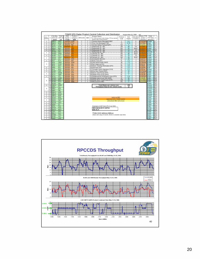
TDWR SPG Radar Product Central Collection and Distribution Version:May 22, 2008 mji
same as 88Dapproved SPG TDWR-centric
Total KBytes per volume scanThroughput Kbps (6 min volume scan)
4
3
2
2
2
3
2
40
RPCCDS Throughput
21
41
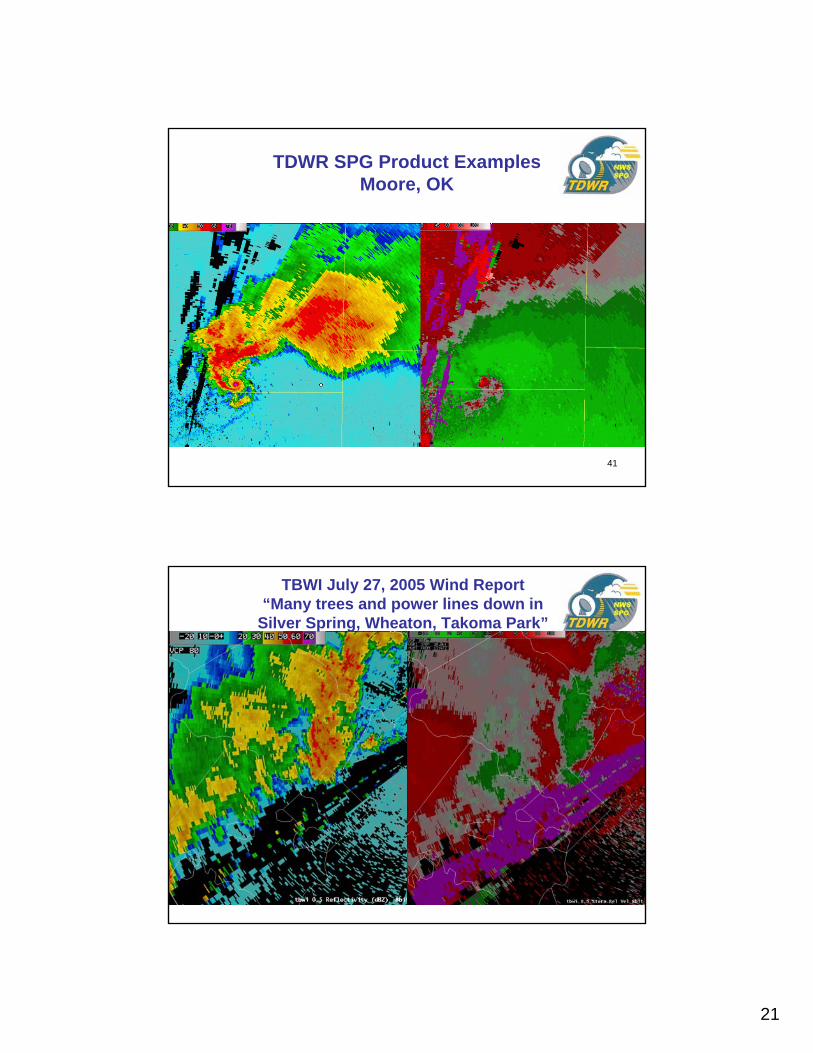
TDWR SPG Product ExamplesMoore, OK
42
TBWI July 27, 2005 Wind Report “Many trees and power lines down in
Silver Spring, Wheaton, Takoma Park”
22
43
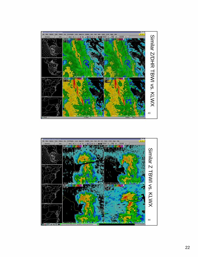
Sim
ilar Z/DH
R TB
WI vs. K
LWX
44
Sim
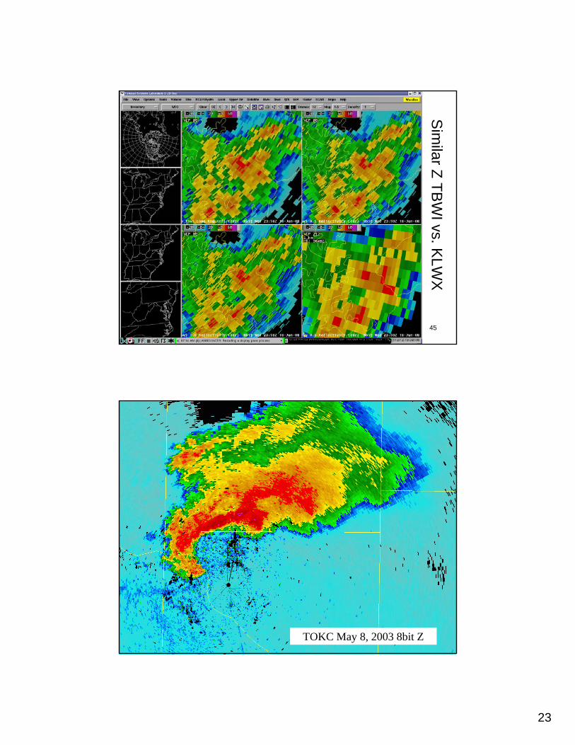
ilar Z TBW
I vs. KLW
X
23
45
Sim
ilar Z TBW
I vs. KLW
X
46TOKC May 8, 2003 8bit Z
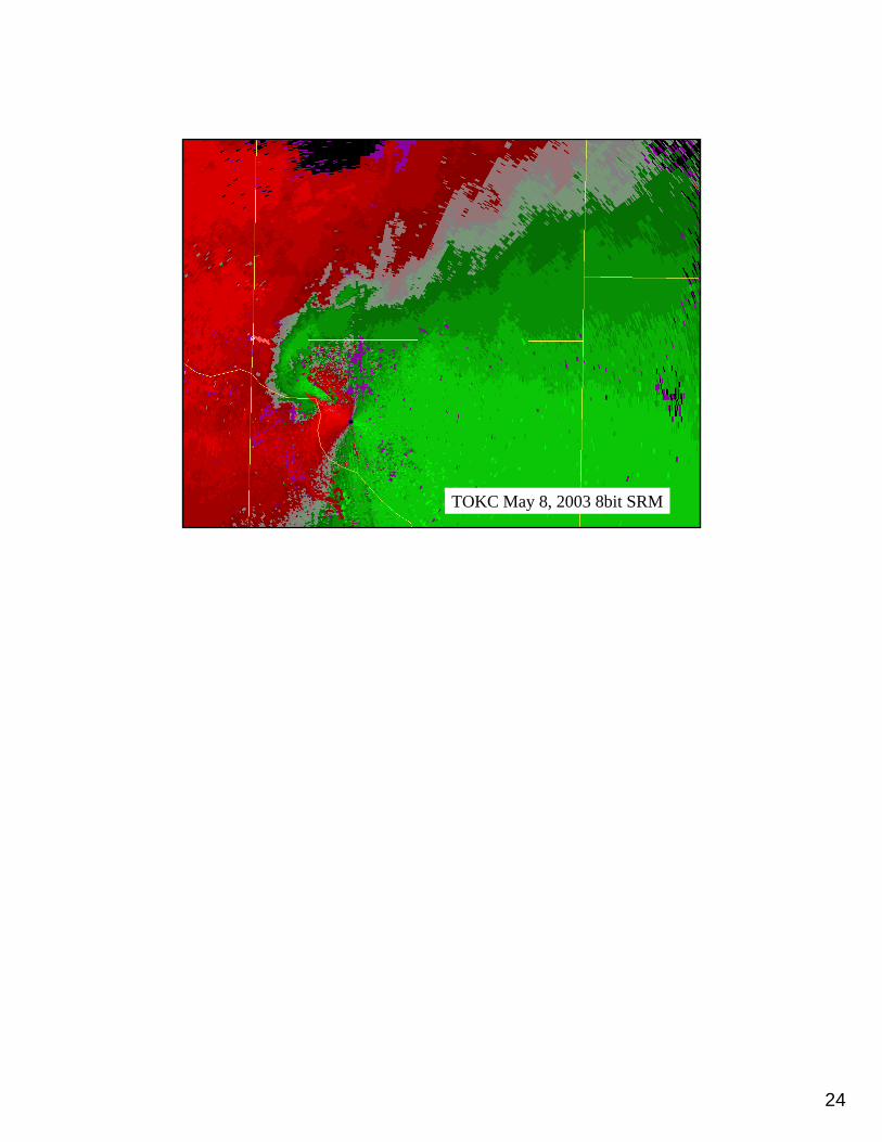
24
47TOKC May 8, 2003 8bit SRM