Embed Size (px)
Citation preview
Spotless Town Residential Survey
Normandy, Missouri
Missouri State Historic Preservation Office Survey # SL-AS-052
Final report
Submitted to
City of Normandy Historic Preservation Commission
7700 Natural Bridge Road
Normandy, MO 63121
Submitted by
Lynn Josse
3517 Connecticut Street
St. Louis MO 63118
June 25, 2017
This project is partially funded by a grant from the Missouri Department of Natural Resources, State Historic
Preservation Office and the U.S. Department of the Interior, National Park Service. Grant awards do not imply
an endorsement of contents by the grantor. Federal laws prohibit discrimination on the basis of race, religion,
sex, age, handicap, or ethnicity. For more information, write to the Office of Equal Opportunity, U.S.
Department of the Interior, Washington D.C. 20240.
Contents Project Background 4
Survey Objectives 5
Methodology 5
Recordation 5
Research 5
Evaluation 6
Geographical Description 7
Historic Context 10
The Development of Normandy 10
Building Spotless Town 15
Sol and Hazel Loewenstein 17
Naming Spotless Town 19
Spotless Town as a private place 21
Residents of Spotless Town 22
Results 25
By the Numbers 25
Property Styles and Types 25
1929-1931: Massed Plan forms 26
Mid-century forms and styles 29
Alterations 30
National Register Eligibility 31
Significance 31
Integrity 32
Local District Eligibility 33
Recommendations 34
Bibliography 35
Guidance for conducting surveys and evaluating resources 35
Sources Consulted 35
Appendix A: Lois Wittke’s Pecan Crispies 39
List of Figures
Figure 1: City of Normandy in St. Louis County (St. Louis City is faintly traced to the right/east of the county). .......... 1 Figure 2: City of Normandy and surrounding municipalities; the arrow points to the Spotless Town survey area. .... 2 Figure 3: Spotless Town survey map .............................................................................................................................. 3 Figure 4: Santa Monica Avenue, camera facing west to Bermuda Drive. Lynn Josse, December 2016. ....................... 7 Figure 5: Santa Monica Avenue, camera facing east to Spotless Town Addition. Lynn Josse, December 2016. .......... 8 Figure 6: Former Sinclair Station (with characteristic roofline intact) transformed for use by the City of Normandy. 9 Figure 7: Spotless Town survey area boundary and original subdivision and addition boundary ................................. 9 Figure 8: Edward Hutawa map; cross hatching indicates New Madrid claims. The white-outlined area is the Barry
tract (with Spotless Town location highlighted). ......................................................................................................... 11 Figure 9: 1904 USGS map shows extent of residential development in that year.. ..................................................... 12 Figure 10: Subdivision Map. Source: Sanborn Map Company, v. 16 index page, based on 1951 updates. ............... 14 Figure 11: Spotless Town plat, filed June 1929. ........................................................................................................... 16 Figure 12: Opening day advertisement (featuring the house at 1102 Bermuda Drive). Source: St. Louis Post-
Dispatch, September 8, 1929. 11B. .............................................................................................................................. 18 Figure 13: Sapolio Advertisement. Source: Colliers Weekly vol. 27 no. 9, June 1, 1901. 12. ....................................... 20 Figure 14: 7605 Santa Monica Avenue. ....................................................................................................................... 26 Figure 15: Speculative original floor plan of side-gabled house. Not to scale. ............................................................ 27 Figure 16: 7608 Santa Monica Avenue. ....................................................................................................................... 28 Figure 17: 7627 San Diego Avenue. ............................................................................................................................. 29 Figure 18: 7633 San Diego Avenue. ............................................................................................................................. 29 Figure 19: 7635 San Diego Avenue. ............................................................................................................................. 30 Figure 20: 7519 San Diego Avenue, where Lois Wittke baked her cookies after World War II.................................... 39 Figure 21: Lois Wittke's Pecan Crispies. Source: St. Louis Star-Times, September 23, 1948. 23. ................................ 39
City of Normandy
Spotless Town Residential Survey Final Report 1
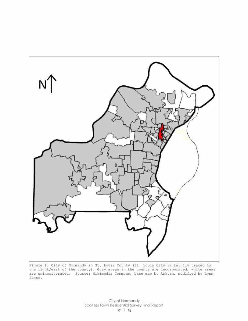
Figure 1: City of Normandy in St. Louis County (St. Louis City is faintly traced to
the right/east of the county). Gray areas in the county are incorporated; white areas
are unincorporated. Source: Wikimedia Commons, base map by Arkyan, modified by Lynn
Josse.
City of Normandy
Spotless Town Residential Survey Final Report 2
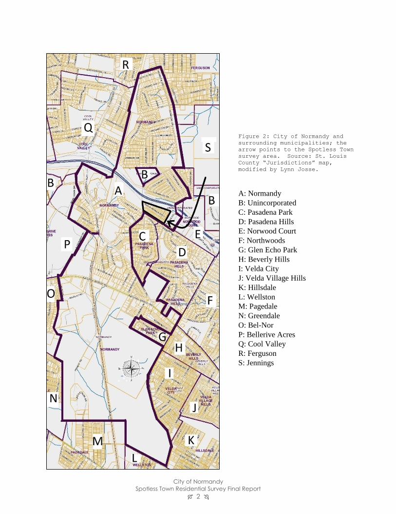
Figure 2: City of Normandy and
surrounding municipalities; the
arrow points to the Spotless Town
survey area. Source: St. Louis
County “Jurisdictions” map,
modified by Lynn Josse.
A: Normandy
B: Unincorporated
C: Pasadena Park
D: Pasadena Hills
E: Norwood Court
F: Northwoods
G: Glen Echo Park
H: Beverly Hills
I: Velda City
J: Velda Village Hills
K: Hillsdale
L: Wellston
M: Pagedale
N: Greendale
O: Bel-Nor
P: Bellerive Acres
Q: Cool Valley
R: Ferguson
S: Jennings
City of Normandy
Spotless Town Residential Survey Final Report 3
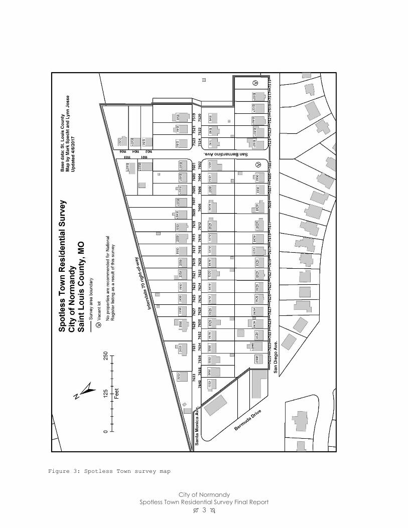
Figure 3: Spotless Town survey map
City of Normandy
Spotless Town Residential Survey Final Report 4
Project Background
In 2013, the City of Normandy completed the steps to become a “Certified Local Government”
(CLG). This designation is awarded by the National Park Service (NPS) and the Missouri State
Historic Preservation Office (SHPO) to local governments that become partners in the
preservation process. Normandy is one of ten municipalities in St. Louis County that are so
designated.1
In order to be certified, a community must undertake five steps:
• Enact a local historic preservation ordinance,
• Maintain a historic preservation commission,
• Conduct public outreach and education,
• Conduct an ongoing survey of historic properties, and
• Satisfactorily perform the responsibilities delegated to the local government by the State
Historic Preservation Office.2
Communities which participate in the CLG program benefit from technical training provided by
the SHPO and are eligible for special grants to further the ongoing survey of historic properties,
nominate eligible resources to the National Register of Historic Places, and undertake other
preservation projects.
The Spotless Town Residential Survey project was initiated by Normandy’s Historic
Preservation Commission as a grant proposal in mid-2015. It was approved for funding from the
State Historic Preservation Office in April 2016. In October, after reviewing several proposals,
the commission selected Lynn Josse as the professional consultant to oversee the project.
This survey is the first step in the creation of an inventory of Normandy’s historic resources, as
well as its first grant-funded project. The Spotless Town subdivision was selected for this pilot
project because of its architectural cohesiveness and its manageable size.
There are two generally recognized approaches to survey projects. The first, the reconnaissance
survey, will generally cover a larger geographical area and include less in-depth historical
background on the individual resources and the survey area as a whole. The second approach,
the intensive-level survey, does the reverse. An intensive survey’ geographic scope is typically
smaller, but each individual resource is researched thoroughly. The final report in the intensive
survey offers more history and context about the area surveyed.
1 The others are Ferguson, Florissant, Kirkwood, Manchester, Oakland, Pasadena Hills, University City, Webster
Groves, and Wildwood. For more information, see Mo SHPO’s Certified Local Government page:
https://dnr.mo.gov/shpo/certifie.htm. 2 https://dnr.mo.gov/shpo/certifie.htm accessed 4/13/2017.
City of Normandy
Spotless Town Residential Survey Final Report 5
Survey Objectives
The Spotless Town Residential Survey is an intensive-level survey with two major goals:
• to identify buildings that may be eligible for listing in the National Register of Historic
Places, and
• to help the community understand the development of the area prior to the city’s
incorporation in 1945.
Because this is the first such project undertaken by the City of Normandy, an additional goal is to
familiarize the City, its Historic Preservation Commission, and its citizens with the processes and
procedures used in historic resource identification and registration.
Methodology
The Spotless Town Residential Survey was undertaken using the methods and standards found in
the National Register of Historic Places’ Guidelines for Local Surveys: A Basis for Preservation
Planning (Bulletin 24)3 and the Missouri State Historic Preservation Office’s “Standards for
Professional and Architectural Surveys.”4
Recordation Between December 2016 and February 2017, the buildings and vacant lots of Spotless Town
were photographed by the consultant and volunteers. Each primary building and site was
recorded by consultant Lynn Josse in a Microsoft Access database and outputted onto forms
which were then double-checked in the field. The data was then exported into a Microsoft Word
editable version of MO SHPO’s general architectural survey form.
Research Archival research was conducted by consultant Lynn Josse and members of Normandy’s Historic
Preservation Commission. Because this is an intensive-level survey, extensive research was
conducted into the histories of individual properties as well as the district as a whole.
The most important sources of information regarding individual owners and renters of Spotless
Town properties were St. Louis County Directories and the United States Census. Newspaper
articles and advertisements were located via an online search and with assistance from the
3 https://www.nps.gov/nr/publications/bulletins/nrb24/. Accessed 4/28/2017. 4 http://dnr.mo.gov/shpo/minsurvgl.htm. Accessed 4/28/2017.
City of Normandy
Spotless Town Residential Survey Final Report 6
Missouri Historical Society. The St. Louis Public Library offered additional clippings on
Normandy’s 1945 incorporation. In the absence of historic St. Louis County building permits,
the daily “Building News” column in the St. Louis Daily Record was scoured for the years 1929-
1930 to find permit summaries. Secondary sources included National Register district
nominations for the adjacent suburbs of Pasadena Hills and Glen Echo Park. St. Louis County’s
Real Estate web site provided useful maps and basic information on nearby subdivisions.
Additional resources were found at the Missouri Historical Society and the St. Louis Public
Library.
In addition to archival research, informal interviews were conducted with residents of Spotless
Town during the survey process. An in-depth interview with Tom Urani, who grew up at 7633
San Diego Avenue, was conducted in January 2017.
Evaluation
Potential for listing in the National Register of Historic Places was evaluated according to the
guidelines in the National Register Bulletin “How to Apply the National Register Criteria for
Evaluation” (Bulletin 15).5
Properties may be listed in the National Register if they possess both significance and integrity.
Historic resources (buildings, sites, structures, objects, and districts) may be listed in the
National Register for their significance in any of four areas. Those that possess significance are
those properties:
A. That are associated with events that have made a significant contribution to the broad
patterns of our history; or
B. That are associated with the lives of significant persons in our past; or
C. That embody the distinctive characteristics of a type, period, or method of construction,
or that represent the work of a master, or that possess high artistic values, or that represent a
significant and distinguishable entity whose components may lack individual distinction; or
D. That have yielded or may be likely to yield, information important in history or
prehistory.6
To understand these broad areas in which a property might be significant, the historic and
archival information uncovered in the research process is organized to illustrate the historic
contexts with which the property might be associated.
In addition to significance, properties listed in the National Register must have integrity. This
means that a resource must be intact enough to convey its significance.
5 Available online https://www.nps.gov/nr/publications/bulletins/nrb15/ 6 National Register Bulletin “How to Apply the National Register Criteria for Evaluation” (Bulletin 15), section II
https://www.nps.gov/nr/publications/bulletins/nrb15/nrb15_2.htm. Accessed 4/13/2017.
City of Normandy
Spotless Town Residential Survey Final Report 7
Geographical Description
The Spotless Town survey area is a 16-acre residential neighborhood located in the City of
Normandy in north St. Louis County (see Figure 2). It is roughly bounded by Interstate 70 on
the north, Bermuda Drive on the west, the Hillcrest Apartments property on the east, and two
single-subdivision municipalities, Pasadena Park and Pasadena Hills, on the south.
The survey area includes parcels facing three streets. San Diego and Santa Monica Avenues are
parallel streets which run approximately east-west. They are connected by San Bernardino
Avenue toward the east end of the survey area. Entrance to the subdivision is from Bermuda
Drive to the west. Traffic flows into the subdivision on Santa Monica Avenue, which is one-way
running east, and exits on San Diego, which is one-way running west. Both streets are two-ways
on the dead-end spurs east of San Bernardino Avenue. San Diego Avenue extends east into the
Hillcrest Apartments complex, but the street is blocked by three large round concrete planters.
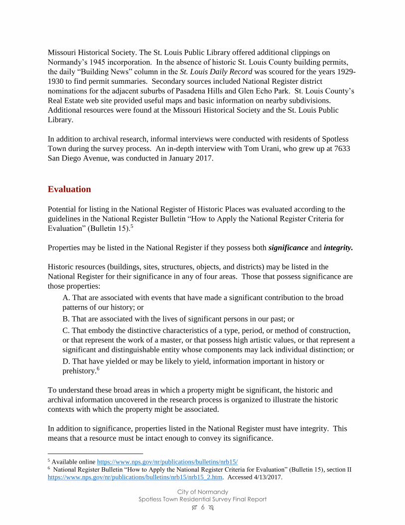
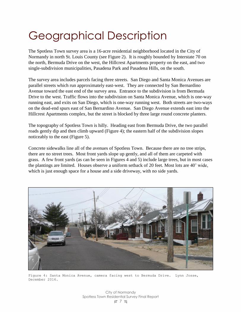
The topography of Spotless Town is hilly. Heading east from Bermuda Drive, the two parallel
roads gently dip and then climb upward (Figure 4); the eastern half of the subdivision slopes
noticeably to the east (Figure 5).
Concrete sidewalks line all of the avenues of Spotless Town. Because there are no tree strips,
there are no street trees. Most front yards slope up gently, and all of them are carpeted with
grass. A few front yards (as can be seen in Figures 4 and 5) include large trees, but in most cases
the plantings are limited. Houses observe a uniform setback of 20 feet. Most lots are 40’ wide,
which is just enough space for a house and a side driveway, with no side yards.
Figure 4: Santa Monica Avenue, camera facing west to Bermuda Drive. Lynn Josse,
December 2016.
City of Normandy
Spotless Town Residential Survey Final Report 8
Although the right-angled plan of Spotless Town would fit neatly into an urban grid, none of the
surrounding developments use a grid layout. To the north, Interstate 70’s right-of-way borders
the properties with a fenced-off line of untended bushes and growth. The property is bounded to
the east by a wide grassy parcel, in the middle of which is the fenced-off pool and pool house
belonging to the Hillcrest Apartments further east. Much of the southern boundary of San Diego
Avenue in the survey area is formed by a retaining wall; the houses on San Diego face the back
yards of those to the south in the municipalities of Pasadena Hills and Pasadena Park. Past the
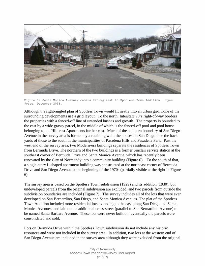
west end of the survey area, two Modern-era buildings separate the residences of Spotless Town
from Bermuda Drive. The northern of the two buildings is a former Sinclair service station at the
southeast corner of Bermuda Drive and Santa Monica Avenue, which has recently been
renovated by the City of Normandy into a community building (Figure 6). To the south of that,
a single-story L-shaped apartment building was constructed at the northeast corner of Bermuda
Drive and San Diego Avenue at the beginning of the 1970s (partially visible at the right in Figure
6).
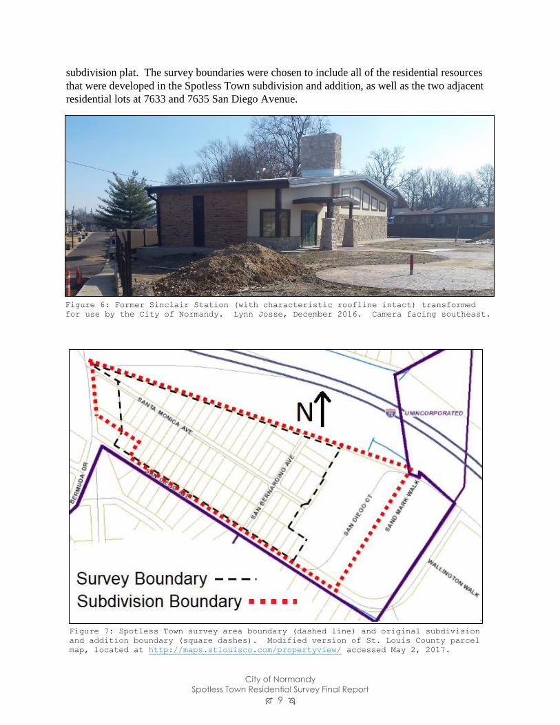
The survey area is based on the Spotless Town subdivision (1929) and its addition (1930), but
undeveloped parcels from the original subdivision are excluded, and two parcels from outside the
subdivision boundaries are included (Figure 7). The survey includes all of the lots that were ever
developed on San Bernardino, San Diego, and Santa Monica Avenues. The plat of the Spotless
Town Addition included more residential lots extending to the east along San Diego and Santa
Monica Avenues, and laid out an additional cross-street (parallel to San Bernardino Avenue) to
be named Santa Barbara Avenue. These lots were never built on; eventually the parcels were
consolidated and sold.
Lots on Bermuda Drive within the Spotless Town subdivision do not include any historic
resources and were not included in the survey area. In addition, two lots at the western end of
San Diego Avenue are included in the survey area although they were excluded from the original
Figure 5: Santa Monica Avenue, camera facing east to Spotless Town Addition. Lynn
Josse, December 2016.
City of Normandy
Spotless Town Residential Survey Final Report 9
subdivision plat. The survey boundaries were chosen to include all of the residential resources
that were developed in the Spotless Town subdivision and addition, as well as the two adjacent
residential lots at 7633 and 7635 San Diego Avenue.
Figure 7: Spotless Town survey area boundary (dashed line) and original subdivision
and addition boundary (square dashes). Modified version of St. Louis County parcel
map, located at http://maps.stlouisco.com/propertyview/ accessed May 2, 2017.
Figure 6: Former Sinclair Station (with characteristic roofline intact) transformed
for use by the City of Normandy. Lynn Josse, December 2016. Camera facing southeast.
City of Normandy
Spotless Town Residential Survey Final Report 10
Historic Context
The Development of Normandy
On the eve of the Louisiana Purchase, most of St. Louis County was unpopulated land. In
addition to the 40-year-old settlement of St. Louis, which had a population of 1,039 in 1800,7
there were small settlements at Carondelet (now part of the City of St. Louis), Florissant, and
Bridgeton.
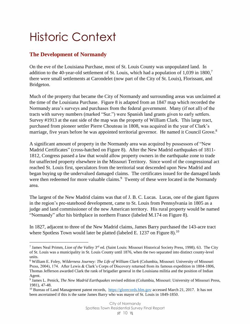
Much of the property that became the City of Normandy and surrounding areas was unclaimed at
the time of the Louisiana Purchase. Figure 8 is adapted from an 1847 map which recorded the
Normandy area’s surveys and purchases from the federal government. Many (if not all) of the
tracts with survey numbers (marked “Sur.”) were Spanish land grants given to early settlers.
Survey #1913 at the east side of the map was the property of William Clark. This large tract,
purchased from pioneer settler Pierre Chouteau in 1808, was acquired in the year of Clark’s
marriage, five years before he was appointed territorial governor. He named it Council Grove.8
A significant amount of property in the Normandy area was acquired by possessors of “New
Madrid Certificates” (cross-hatched on Figure 8). After the New Madrid earthquakes of 1811-
1812, Congress passed a law that would allow property owners in the earthquake zone to trade
for unaffected property elsewhere in the Missouri Territory. Since word of the congressional act
reached St. Louis first, speculators from the territorial seat descended upon New Madrid and
began buying up the undervalued damaged claims. The certificates issued for the damaged lands
were then redeemed for more valuable claims.9 Twenty of these were located in the Normandy
area.
The largest of the New Madrid claims was that of J. B. C. Lucas. Lucas, one of the giant figures
in the region’s pre-statehood development, came to St. Louis from Pennsylvania in 1805 as a
judge and land commissioner of the new American territory. His rural property would be named
“Normandy” after his birthplace in northern France (labeled M.174 on Figure 8).
In 1827, adjacent to three of the New Madrid claims, James Barry purchased the 143-acre tract
where Spotless Town would later be platted (labeled E. 1237 on Figure 8).10
7 James Neal Primm, Lion of the Valley 3rd ed. (Saint Louis: Missouri Historical Society Press, 1998). 63. The City
of St. Louis was a municipality in St. Louis County until 1876, when the two separated into distinct county-level
units. 8 William E. Foley, Wilderness Journey: The Life of William Clark (Columbia, Missouri: University of Missouri
Press, 2004), 174. After Lewis & Clark’s Corps of Discovery returned from its famous expedition in 1804-1806,
Thomas Jefferson awarded Clark the rank of brigadier general in the Louisiana militia and the position of Indian
Agent. 9 James L. Penick, The New Madrid Earthquakes revised edition (Columbia, Missouri: University of Missouri Press,
1981), 47-48. 10 Bureau of Land Management patent records, https://glorecords.blm.gov accessed March 21, 2017. It has not
been ascertained if this is the same James Barry who was mayor of St. Louis in 1849-1850.
City of Normandy
Spotless Town Residential Survey Final Report 11
Figure 8: Edward Hutawa map; cross hatching indicates New Madrid claims. The white-outlined
area is the Barry tract (with Spotless Town location highlighted).
City of Normandy
Spotless Town Residential Survey Final Report 12
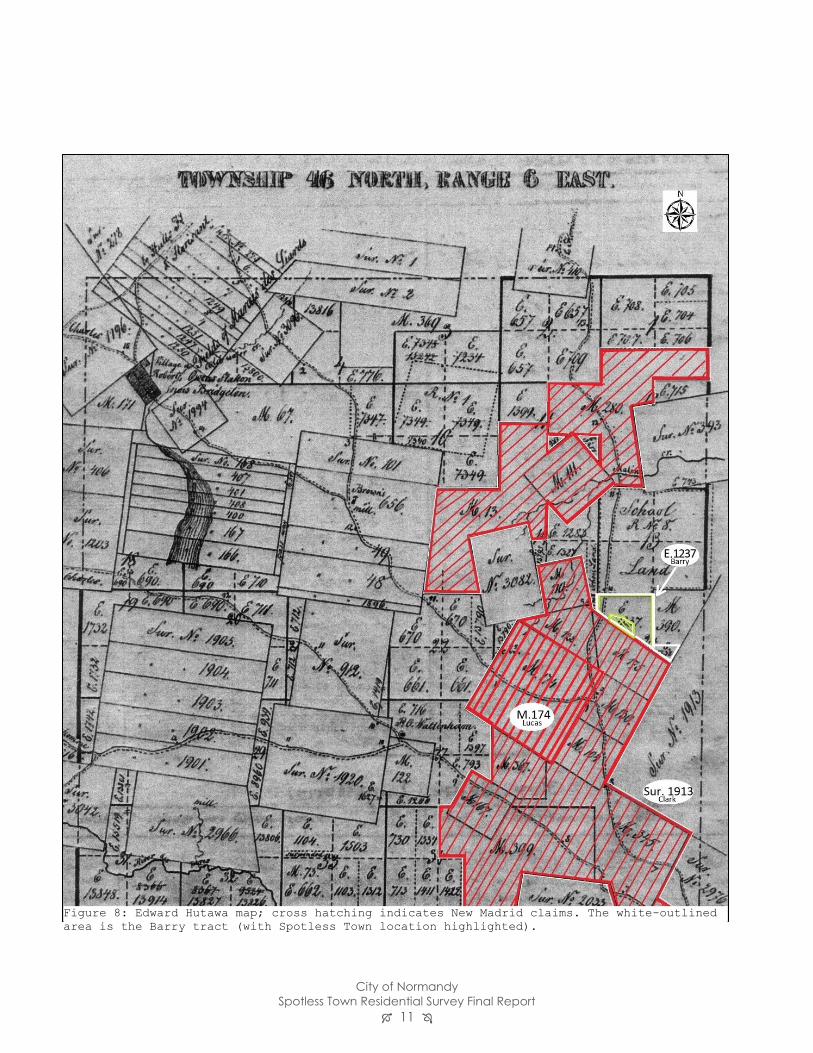
By the middle of the nineteenth century, Natural Bridge and Florissant Road assumed their
present courses, and a toll booth was established at their intersection (Figure 9). A small
crossroads settlement developed and took its name from the Lucas estate.11 The West End
Narrow Gauge Railroad connected the Normandy area with downtown St. Louis in 1875, and ran
all the way north to the town of Florissant by 1878.12 This route was electrified as a streetcar in
11 Gill, Bob. “Crossroads: Memories of the Normandy Wedge.” Normandy Area Historical Association. n. d.
http://www.cityofnormandy.gov/DocumentCenter/Home/View/582 , accessed 3/21/2017. “Early Transportation St.
Louis City and County” in “History of Normandy” document, dated September 1973. Missouri Historical Society
Archives. 13 12 Davison, Rosemary. Rail, Mail & Dreams. Historic Florissant, Inc, 2009. 10-11.
Figure 9: 1904 USGS map shows extent of residential development in that year. The
suburb of Wellston is developing adjacent to the St. Louis city limits to the
southeast, and Jennings to the northeast. Source: University of Alabama Map
collection.
City of Normandy
Spotless Town Residential Survey Final Report 13
1891, was absorbed into the United Railways system after the turn of the century, and operated
until 1931.13
Despite this rail connection, in the 19th century the Normandy area experienced relatively little
development beyond the small community near the toll station. By 1900, land divisions were
still fairly large. Most of the sparsely built residences lined major county roads. Figure 9 shows
that the exceptions to this pattern were in two subdivisions, Normandy Heights and “Oehler’s
Place at Normandy.” Located just west of the wedge formed by Old Florissant and Natural
Bridge Roads, Normandy Heights was platted in 1889. Its southern two blocks were developed
first; the northern section was eventually replatted and built up after World War II. Just south of
the intersection, Oehler’s Place was platted in 1890. (Over the years, the area between and
around Natural Bridge and Florissant – now Old Florissant – just west of their intersection
became known simply as “The Wedge,” and it is still referred to as such today.)
In the meantime, Barry heirs had retained the northern section of the family’s 1827 purchase,
while the southern section (including the future site of Spotless Town) had been sold to “C.
Anderson & W. Fred” by 1893.14 In 1908, Charles and Augusta Deutschmann purchased the
southern portion of that property from Mary L. Anderson et al. The 1920 census shows that they
lived on site with three of their five children.
The boundaries of the City of St. Louis, just a mile and a half from the Normandy Wedge (at its
closest point), had been set in 1876 when the City separated itself from St. Louis County. At that
time, there was still plenty of room within the city limits for growth. But in the first few decades
of the 20th century, the expanding area of urbanization overspilled the City’s confines at all but
its southwest borders. St. Louis County communities which had developed independently as
agricultural centers or waystations soon found themselves in the path of suburbanization.
Figure 9 illustrates that by 1904, development had already crossed from the city into near north
St. Louis County at Wellston. In this as in most of the other turn-of-the-century suburbs, the
extension and electrification of the streetcar system from the City of St. Louis spurred ongoing
growth. Easton Avenue in Wellston became one of the city’s busiest commercial districts,
becoming both a community hub and a destination for shoppers throughout the city and county.15
Because it was farther from the urban center, the vicinity of Normandy did not develop as
quickly. The 1909 atlas shows that many of the larger parcels were still undivided at that time.
In the 1920 census, six of the 16 household enumerated on Old Florissant Road north of Natural
Bridge Road (including the Deutschmanns) are listed as farms.
All of this changed in the 1920s, based on factors such as the availability of land, the
development of transit, and growing popularity of the automobile. Two subdivisions adjacent to
13 Ibid. 33, 34. 14 An Atlas of St. Louis County in the State of Missouri, 1893. Clayton, Missouri: C.R. Black, 1893.
http://digital.shsmo.org/cdm/ref/collection/plat/id/6768 accessed April 28, 2017. 15 Lindsey Derrington et al, “Wellston Loop Commercial Historic District” National Register nomination, listed
9/9/2010.
City of Normandy
Spotless Town Residential Survey Final Report 14
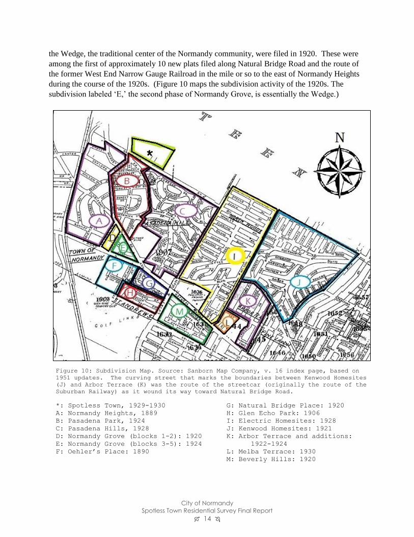
the Wedge, the traditional center of the Normandy community, were filed in 1920. These were
among the first of approximately 10 new plats filed along Natural Bridge Road and the route of
the former West End Narrow Gauge Railroad in the mile or so to the east of Normandy Heights
during the course of the 1920s. (Figure 10 maps the subdivision activity of the 1920s. The
subdivision labeled ‘E,’ the second phase of Normandy Grove, is essentially the Wedge.)
Figure 10: Subdivision Map. Source: Sanborn Map Company, v. 16 index page, based on
1951 updates. The curving street that marks the boundaries between Kenwood Homesites
(J) and Arbor Terrace (K) was the route of the streetcar (originally the route of the
Suburban Railway) as it wound its way toward Natural Bridge Road.
*: Spotless Town, 1929-1930 G: Natural Bridge Place: 1920
A: Normandy Heights, 1889 H: Glen Echo Park: 1906
B: Pasadena Park, 1924 I: Electric Homesites: 1928
C: Pasadena Hills, 1928 J: Kenwood Homesites: 1921
D: Normandy Grove (blocks 1-2): 1920 K: Arbor Terrace and additions:
E: Normandy Grove (blocks 3-5): 1924 1922-1924
F: Oehler’s Place: 1890 L: Melba Terrace: 1930
M: Beverly Hills: 1920
City of Normandy
Spotless Town Residential Survey Final Report 15
By the end of the 1920s, with the ascendancy of the automobile, Americans were less dependent
on fixed transit routes. New suburban development no longer needed to locate adjacent to
existing streetcar lines. The National Register nomination for Pasadena Hills (platted in 1928
immediately south of the survey area) notes that the subdivision’s monumental gate was actually
located between the streetcar line and Natural Bridge Road; it served as a gate only for those
who came by auto.16 Spotless Town, platted in 1929 and 1930, was half a mile away from the
nearest transit route. In some of its roomier advertisements, the promoters offered instructions
on how to reach the new development by bus, but most of the ads only offered driving directions.
During the course of the 1930s, many of the subdivisions in the area filed for incorporation in
order to preserve their boundaries and to avoid being annexed into other county municipalities.
The first in the area to do so was Beverly Hills in 1933, followed by Pasadena Park (directly
south of Spotless Town) in 1935. Glen Echo Park, Pasadena Hills, Bel-Nor, Velda Village,
Northwoods, Margona Village (later absorbed into the City of St. John), and Bellerive followed
by the end of the decade.17
In 1945, the tiny city of Beverly Hills proposed expanding to the west, a move that would annex
the wedge at Natural Bridge and Florissant. In response, representatives of four Normandy
neighborhoods (Spotless Town, Normandy Place, Normandy Heights, and Normandy Grove),
met to discuss incorporation.18 After a successful petition to the county court, the new Town of
Normandy was incorporated on March 30, 1945.19
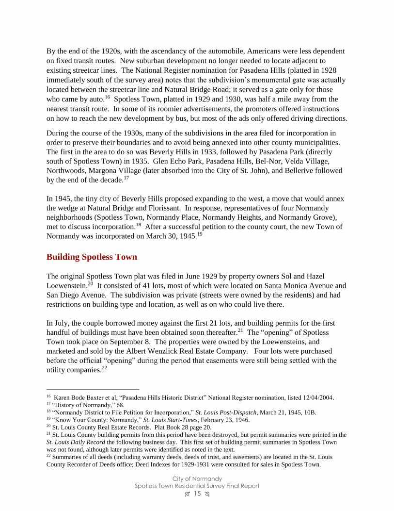
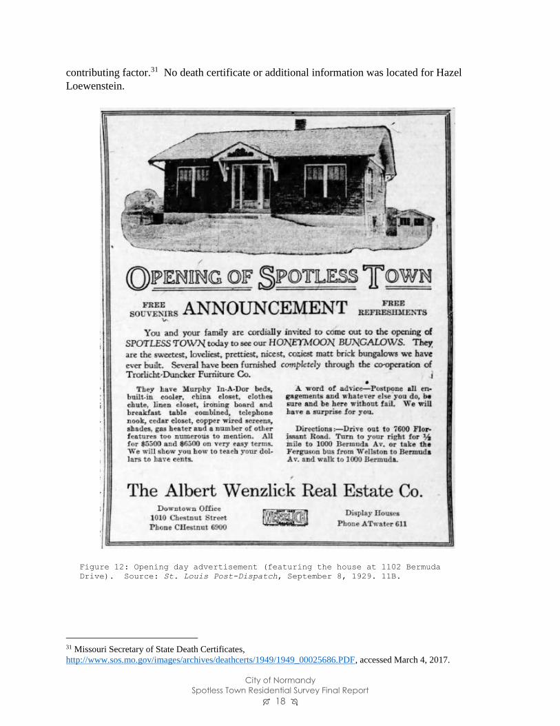
Building Spotless Town
The original Spotless Town plat was filed in June 1929 by property owners Sol and Hazel
Loewenstein.20 It consisted of 41 lots, most of which were located on Santa Monica Avenue and
San Diego Avenue. The subdivision was private (streets were owned by the residents) and had
restrictions on building type and location, as well as on who could live there.
In July, the couple borrowed money against the first 21 lots, and building permits for the first
handful of buildings must have been obtained soon thereafter.21 The “opening” of Spotless
Town took place on September 8. The properties were owned by the Loewensteins, and
marketed and sold by the Albert Wenzlick Real Estate Company. Four lots were purchased
before the official “opening” during the period that easements were still being settled with the
utility companies.22
16 Karen Bode Baxter et al, “Pasadena Hills Historic District” National Register nomination, listed 12/04/2004. 17 “History of Normandy,” 68. 18 “Normandy District to File Petition for Incorporation,” St. Louis Post-Dispatch, March 21, 1945, 10B. 19 “Know Your County: Normandy,” St. Louis Start-Times, February 23, 1946. 20 St. Louis County Real Estate Records. Plat Book 28 page 20. 21 St. Louis County building permits from this period have been destroyed, but permit summaries were printed in the
St. Louis Daily Record the following business day. This first set of building permit summaries in Spotless Town
was not found, although later permits were identified as noted in the text. 22 Summaries of all deeds (including warranty deeds, deeds of trust, and easements) are located in the St. Louis
County Recorder of Deeds office; Deed Indexes for 1929-1931 were consulted for sales in Spotless Town.
City of Normandy
Spotless Town Residential Survey Final Report 16
While all of the houses appear to have been built to two basic designs, it appears that different
builders were hired to complete different phases of the project. For example, J. M. Christian was
listed as the builder on six dwellings permitted in June 1930, while Fred Holzum was the builder
of 22 dwellings with the same designs permitted that December.23 The architect of the houses
has not been identified.
During the first months, property sold well. The Loewensteins began to build more houses on
spec. By April 1930, the U. S. Census recorded 21 households living on San Diego and Santa
Monica (out of 37 total lots on San Diego, Sant Monica, and San Bernardino). Most lots in the
original subdivision had been sold by the end of 1930.
In December 1930, the Loewensteins filed the Spotless Town Addition. This new plat added 47
lots on San Diego, Santa Monica, San Bernardino, and a new street to be called Santa Barbara.
No sales in the new subdivision were filed until June 1931. Most of the new addition, to the east
of the survey area, was never developed and still remains as open land.24 The only lots sold as
home sites were those within the present survey area.
23 “Building News” Section, St. Louis Daily Record, June 5, 1930 and December 12, 1930. 24 In the 1950s, the remaining lots in Spotless Town made the news when a widow alleged that instead of investing
her money in “high class deeds of trust and construction loans,” real estate agent Thomas Gilpin used it to secure
loans on property he already owned in Spotless Town, which was described as an “undeveloped, weed-overgrown
subdivision in Normandy.” “Gilpin Accused of Transfers of Firm Property,” St. Louis Post-Dispatch, January 26,
1956, 1; “Asserts Funds Apparently Went to Gilpin’s Personal Use,” St. Louis Post-Dispatch, January 5, 1956, 1.
Figure 11: Spotless Town plat, filed June 1929.
City of Normandy
Spotless Town Residential Survey Final Report 17
All of the houses in Spotless Town and its addition were built to one of two basic designs. The
houses with side gabled roofs had 750 square feet of floor space, and the front gabled model, 900
square feet. They were marketed as “Honeymoon Bungalows” - perfect homes for two people
starting out in life. Since the subdivision was geared towards motorists, each house was
advertised as being built with a garage.25 There are no records of how many garages were
actually built, but the 1937 aerial map does appear to show a detached garage behind nearly
every house on Santa Monica Avenue. There appear to be fewer on San Diego Avenue.26
Sol and Hazel Loewenstein
The Loewensteins are elusive figures who seem to have left little trace in the historical record.
Sol was born c. 1895 in either Seattle (per his death certificate), Pennsylvania (according to the
1930 census), or Oregon (according to the 1940 census). Hazel was born c. 1900, possibly in
Pennsylvania (1930 census) or Iowa (1940 census). Sol Loewenstein was not found in the 1920
census, and the couple’s c. 1921 marriage was not recorded in Missouri.
Loewenstein’s real estate career is first documented in 1928, when, as the “exclusive agent” for
the Radio Bungalow Company, he placed 24 bungalows on the market in the Glenechort
subdivision.27 (The Missouri Secretary of State has no records of a “Radio Bungalow”
company,28 and an internet search returned no relevant results.) A look in Glenechort reveals
that many of the houses, presumably some of those built by the Loewensteins, are nearly
identical to the side-gabled houses they built two miles north in Spotless Town a year later.
The 1930 census shows that Sol and Hazel Loewenstein had moved into the model house
constructed at 1002 Bermuda on Spotless Town block 1, lot 1. Sol’s occupation was listed as
“builder.” By 1940, the couple had moved to the city of Jennings, another inner-ring suburb
northeast of Normandy, and were renting property there. At that time Sol was listed as a real
estate salesman. His name disappears from the Post-Dispatch after 1931, except for a series of
classified advertisements selling property in 1943.29
Sol passed away on June 3, 1949. The four-line death notice in the St. Louis Post-Dispatch
briefly stated that he was the beloved husband of Hazel Loewenstein and that the interment
would be private.30 His death certificate noted that the couple lived on Carl Avenue in Jennings.
The cause of death was “believed to be coronary occlusion,” with nervous strain as a likely
25 An example of such an advertisement is found in the St. Louis Post-Dispatch, July 27, 1930. 6D. 26 The 1937 aerial layer on St. Louis County’s real estate web site is accessible from
https://revenue.stlouisco.com/IAS/. 27 “Radio Bungalow Co.” Advertisement, St. Louis Star, June 2, 1928, 7; “24 New Bungalows are put on Market,”
St. Louis Star, November 15, 1928, 25. The Glenechort subdivision is located about 2.2 miles south of Spotless
Town. 28 Business name search at www.sos.mo.gov conducted 3/21/2017. 29 Newspapers.com search conducted on March 23, 2017. Classified advertisements found on April 13, 14, 18, and
September 19, 1943. 30 Death Notices, St. Louis Post-Dispatch, June 7, 1949. 26.
City of Normandy
Spotless Town Residential Survey Final Report 18
contributing factor.31 No death certificate or additional information was located for Hazel
Loewenstein.
31 Missouri Secretary of State Death Certificates,
http://www.sos.mo.gov/images/archives/deathcerts/1949/1949_00025686.PDF, accessed March 4, 2017.
Figure 12: Opening day advertisement (featuring the house at 1102 Bermuda
Drive). Source: St. Louis Post-Dispatch, September 8, 1929. 11B.

City of Normandy
Spotless Town Residential Survey Final Report 19
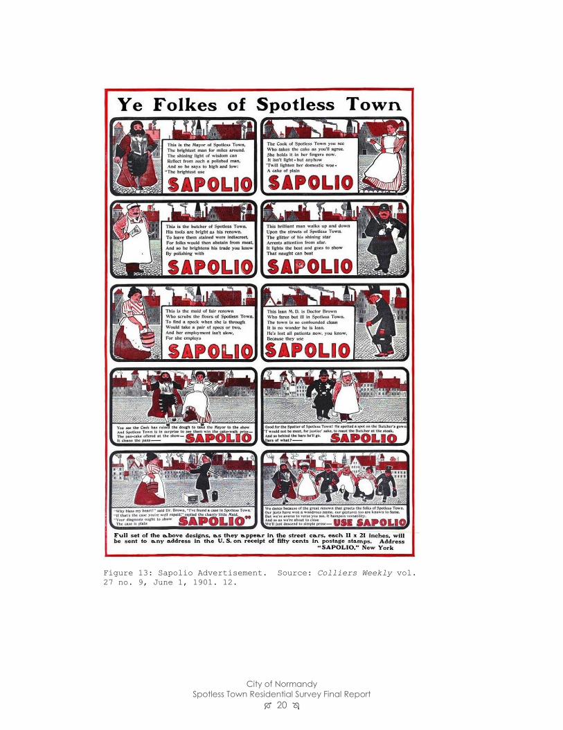
Naming Spotless Town
In the early 20th century, “Spotless Town” had become a common phrase in the American
vocabulary thank to a visionary advertising campaign for soap.
Sapolio soap was produced by Enoch Morgan’s Sons Company beginning in 1869. The brand
was known for its catchy advertising by the mid-1880s, but it was the Spotless Town campaign
that made it a national phenomenon. In 1900, a series of advertisements in streetcars, magazines,
and newspapers introduced the residents of the fictional “Spotless Town” (Figure 13). Each
resident was known for his or her cleanliness, and of course, achieved it with Sapolio. The
campaign’s popularity was so great that “allusions to Spotless Town soon became a familiar
sight in newspapers, on the streets, in public speeches, and even on stage.”32 As the phrase made
its way into the mainstream, city councils “passed resolutions calling upon the inhabitants to co-
operate in making them real Spotless Towns,”33 and at least one community changed its name to
Spotless Town.34
Within the subdivision, street names honored cities in California: San Diego, Santa Monica, San
Bernardino, and Santa Barbara (platted as part of the Spotless Town Addition but never
developed). Throughout the 1920s, it was common for subdivisions and streets in the St. Louis
area to be named for California communities. In some cases, it appears that this was an
intentional strategy to evoke the glamor of Hollywood, particularly in cases where revival style
homes could recall the famous homes of celebrities.35 It is also possible that for some
subdivisions, the use of California place names was intended to bring to mind the modern
domesticity found in the style still called the “California bungalow.” The North County
subdivisions of Beverly Hills (1920), Pasadena Park (1924) and Pasadena Hills (1928) used
California place names. The streets in Spotless Town appear to be the only local streets named
for California locations.
32 Juliann Sivulka, Soap, Sex, and Cigarettes: A Cultural History of American Advertising 2nd ed. (Boston:
Wadsworth, 2012). 70-72. 33 “Spotless Town Advertising” letter to the editor, Printers’ Ink v. 106 No. 2, January 9, 1919. 48 34 Julian Lewis Watkins, The 100 Greatest Advertisements 1852-1958: Who Wrote them and What They Did, Dover
reprint, 1993. 13. 35 NiNi Harris and Lynn Josse, “Holly Hills Historic District” nomination to NRHP, listed March 22, 2016.
City of Normandy
Spotless Town Residential Survey Final Report 20
Figure 13: Sapolio Advertisement. Source: Colliers Weekly vol.
27 no. 9, June 1, 1901. 12.

City of Normandy
Spotless Town Residential Survey Final Report 21
Spotless Town as a private place
The development of “private places” has long been recognized as a phenomenon which began in
and shaped St. Louis in the second half of the 19th century. Private places are streets that are
privately owned and maintained by the residents, and which use devices such as deed restrictions
to regulate growth and development.36 While the development of private places in the City of St.
Louis is well understood, the later history of private places as they spread through St. Louis
County has not been extensively studied.
St. Louis’ first private place was Lucas Place, laid out just west of the city limits in 1851 (now
the 1400 and 1500 blocks of Locust Street, considered a downtown location). Property owner
James Lucas and architect George I. Barnett planned the new subdivision to restrict traffic, and
to exclude commercial and industrial uses.37
Later private places, beginning with Benton Place in 1868, generally adhered to the same
principles. Streets were the responsibility of a residents’ association; use and residency
restrictions were enforced to the extent practical; 38 and minimum standards for construction
were almost always set. For example, in Westmoreland and Portland Places (laid out in 1888 as
the “fullest and finest development” of the private place concept, according to Savage39), lots
were 100 feet wide, building lines were 40 feet back from the property’s front line, no house
could cost less than $7000, and building designs required approval from the trustees.40 These
and related measures resulted in an architectural consistency that protected the character of the
new neighborhood.
The first private subdivision in St. Louis County was Webster Park in the city of Webster Groves
(1892). By 1915, large sections of the inner-ring suburbs of Clayton and University City had
been developed with private places.41 Pasadena Hills, opened directly south of Spotless Town in
1928, was the last of the private places to erect a monumental entrance gate.42
Pasadena Hills would have been the closest and most recent precedent when Sol and Hazel
Loewenstein filed the plat for Spotless Town in the following year. Both Santa Monica and San
Bernardino Avenues were owned by the trustees of Spotless Town, a board which was to be
36 The seminal work on private places in St. Louis (and still the standard) is Charles C. Savage’s Architecture of the
Private Streets of St. Louis (Columbia, Missouri: University of Missouri Press, 1987). Savage explores the history
and possible precedents for these streets, with emphasis on architecture and design. 37 Savage, 8 and 13. James Lucas, by the way, was the son and primary heir of Judge J. B. C. Lucas, who had
claimed the Normandy tract. James inherited ¾ of that tract (the other quarter going to his sister Anne Lucas Hunt)
and was responsible for developing it as one of the county’s great estates. 38 The trustees of Bell Place had, by the 1920s, backed away from testing the limits of their powers of enforcement,
having come to the conclusion that they might not win in a court battle to prevent the construction of multi-family
housing where the “private place” fronted on Delmar Boulevard. Lynn Josse, “Waterman Place/Kingsbury
Place/Washington Terrace Historic District” National Register nomination, listed 6/12/2007. 39 Savage, 42. 40 Savage, 43. 41 Esley Hamilton, Hampton Park Historic District National Register nomination, listed 12/21/2005. 22. 42 Karen Bode Baxter et al, “Pasadena Hills Historic District” National Register nomination, listed 12/04/2004. 109.
City of Normandy
Spotless Town Residential Survey Final Report 22
elected annually. (San Diego Avenue was not privately owned.) The property restrictions on the
residential lots were fairly standard:
No dwelling shall be erected in any part of this subdivision which shall cost less than
$3000.00, nor shall any dwelling be constructed of other than brick or similar fireproof
material…. No house or lot or any portion of a lot in this subdivision shall be sold to,
owned, leased, erected or occupied by person or persons other than the Caucasian Race.
No saloon, slaughter-house, dairy, livery-stable, or other nuisance shall be erected,
maintained or operated in any part of this subdivision. …43
While private streets are extremely common in some parts of St. Louis County (it has been
estimated that two-thirds of the suburb of Ladue is private),44 their extent has never been
systematically studied.
Spotless Town may be the first private subdivision of intentionally modest houses identified as
part of the survey process in St. Louis County, but there is at this time no evidence to indicate it
is the only one that exists. Dozens of subdivisions opened up in north St. Louis County in the
first few decades of the 20th century. As yet, very few of them have been studied.
Our understanding of Spotless Town as a small private place of near-identical cottages is limited
by lack of context. This facet of the neighborhood’s history is fascinating, but its significance
cannot be explored without a fuller knowledge of the use of private streets in small residential
development throughout all of (or this part of) St. Louis County.
Residents of Spotless Town
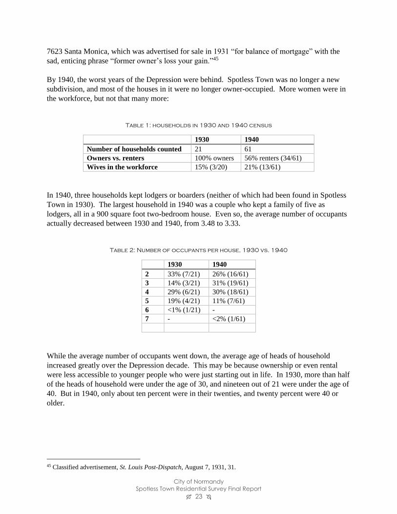
In April 1930, census takers enumerated the first 21 households on Santa Monica and San Diego
Avenues. All 21 of the houses were occupied by their new owners; there were no renters in the
subdivision. Seven of the 21 households were occupied by couples with no children at home
(presumably the target of the “honeymoon bungalow” advertising). One household consisted of
a widow with two adult daughters. All twenty husbands were in the workforce, and three wives.
Most occupations were blue-collar: glaziers, laborers, a mason, a taxi driver, etc. There was also
one attorney.
During the Depression, County Directories show that there was a high rate of turnover in
Spotless Town. More than two thirds of the households had changed residents between 1932 and
1934. Some of the early sales failed during the first years of the Depression, as in the case of
43 Spotless Town plat, St. Louis County Recorder of Deeds plat book 20 page 28. 44 Conversation with Esley Hamilton, January 3, 2017.
City of Normandy
Spotless Town Residential Survey Final Report 23
7623 Santa Monica, which was advertised for sale in 1931 “for balance of mortgage” with the
sad, enticing phrase “former owner’s loss your gain.”45
By 1940, the worst years of the Depression were behind. Spotless Town was no longer a new
subdivision, and most of the houses in it were no longer owner-occupied. More women were in
the workforce, but not that many more:
Table 1: households in 1930 and 1940 census
1930 1940
Number of households counted 21 61
Owners vs. renters 100% owners 56% renters (34/61)
Wives in the workforce 15% (3/20) 21% (13/61)
In 1940, three households kept lodgers or boarders (neither of which had been found in Spotless
Town in 1930). The largest household in 1940 was a couple who kept a family of five as
lodgers, all in a 900 square foot two-bedroom house. Even so, the average number of occupants
actually decreased between 1930 and 1940, from 3.48 to 3.33.
Table 2: Number of occupants per house, 1930 vs. 1940
1930 1940
2 33% (7/21) 26% (16/61)
3 14% (3/21) 31% (19/61)
4 29% (6/21) 30% (18/61)
5 19% (4/21) 11% (7/61)
6 <1% (1/21) -
7 - <2% (1/61)
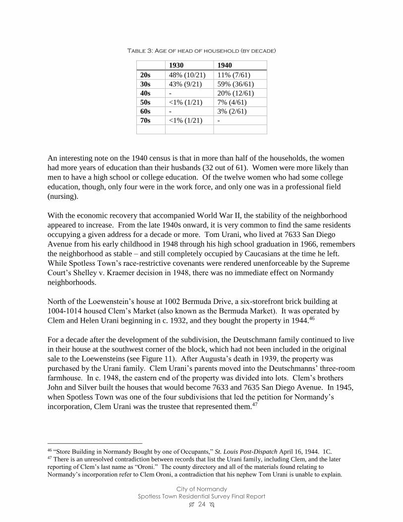
While the average number of occupants went down, the average age of heads of household
increased greatly over the Depression decade. This may be because ownership or even rental
were less accessible to younger people who were just starting out in life. In 1930, more than half
of the heads of household were under the age of 30, and nineteen out of 21 were under the age of
40. But in 1940, only about ten percent were in their twenties, and twenty percent were 40 or
older.
45 Classified advertisement, St. Louis Post-Dispatch, August 7, 1931, 31.
City of Normandy
Spotless Town Residential Survey Final Report 24
Table 3: Age of head of household (by decade)
1930 1940
20s 48% (10/21) 11% (7/61)
30s 43% (9/21) 59% (36/61)
40s - 20% (12/61)
50s <1% (1/21) 7% (4/61)
60s - 3% (2/61)
70s <1% (1/21) -
An interesting note on the 1940 census is that in more than half of the households, the women
had more years of education than their husbands (32 out of 61). Women were more likely than
men to have a high school or college education. Of the twelve women who had some college
education, though, only four were in the work force, and only one was in a professional field
(nursing).
With the economic recovery that accompanied World War II, the stability of the neighborhood
appeared to increase. From the late 1940s onward, it is very common to find the same residents
occupying a given address for a decade or more. Tom Urani, who lived at 7633 San Diego
Avenue from his early childhood in 1948 through his high school graduation in 1966, remembers
the neighborhood as stable – and still completely occupied by Caucasians at the time he left.
While Spotless Town’s race-restrictive covenants were rendered unenforceable by the Supreme
Court’s Shelley v. Kraemer decision in 1948, there was no immediate effect on Normandy
neighborhoods.
North of the Loewenstein’s house at 1002 Bermuda Drive, a six-storefront brick building at
1004-1014 housed Clem’s Market (also known as the Bermuda Market). It was operated by
Clem and Helen Urani beginning in c. 1932, and they bought the property in 1944.46
For a decade after the development of the subdivision, the Deutschmann family continued to live
in their house at the southwest corner of the block, which had not been included in the original
sale to the Loewensteins (see Figure 11). After Augusta’s death in 1939, the property was
purchased by the Urani family. Clem Urani’s parents moved into the Deutschmanns’ three-room
farmhouse. In c. 1948, the eastern end of the property was divided into lots. Clem’s brothers
John and Silver built the houses that would become 7633 and 7635 San Diego Avenue. In 1945,
when Spotless Town was one of the four subdivisions that led the petition for Normandy’s
incorporation, Clem Urani was the trustee that represented them.47
46 “Store Building in Normandy Bought by one of Occupants,” St. Louis Post-Dispatch April 16, 1944. 1C. 47 There is an unresolved contradiction between records that list the Urani family, including Clem, and the later
reporting of Clem’s last name as “Oroni.” The county directory and all of the materials found relating to
Normandy’s incorporation refer to Clem Oroni, a contradiction that his nephew Tom Urani is unable to explain.
City of Normandy
Spotless Town Residential Survey Final Report 25
Results
By the Numbers
Sixty-seven separate parcels are included within the boundaries of the Spotless Town Residential
Survey, including two vacant lots. A total of 65 dwellings were surveyed, along with 18
associated outbuildings.
Property Styles and Types
The analysis of property types in the survey area gives us the opportunity to study in-depth the
built resources of the area. In the case of Spotless Town, the analysis is somewhat simpler than
most, since the houses that Sol and Hazel Loewenstein built conform to two basic floor plans.
Within the area, there are 65 single family residences and 18 outbuildings. Most of the original
garages noted on the 1937 aerial map did not survive; the majority of those outbuildings noted in
the survey do not appear to be original. Of the residences, 63 were built between 1929-1931 as
part of the Spotless Town Subdivision and Addition. Three additional residences (no longer
extant) were also part of the original Spotless Town development. The house at 7603 San Diego
was apparently destroyed in “an explosion of unknown origin” in January 1933.48 The house at
7515 San Diego Avenue was torn down between 1997 and 2000, according to St. Louis County
aerial map data. Sol and Hazel Lowenstein’s own house at 1002 Bermuda (outside of the survey
area) was razed between 2012 and 2014.
Table 4: Dates of Construction within survey boundaries
Date Number of
residences
Number
extant
Property type
1929-1931 65 63 Side-gabled Massed Plan Form: 46
Front-Gabled Massed Plan Form: 17
c. 1948 2 2 Minimal Traditional/Cape Cod: 1
Minimal Traditional/other: 1
Total 67 65
48 “Normandy Home Wrecked by Unexplained Explosion,” St. Louis Post-Dispatch, January 6, 1933, 11A.
City of Normandy
Spotless Town Residential Survey Final Report 26
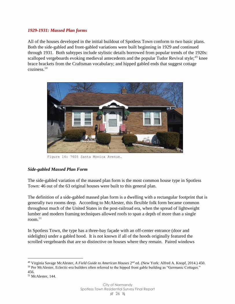
1929-1931: Massed Plan forms
All of the houses developed in the initial buildout of Spotless Town conform to two basic plans.
Both the side-gabled and front-gabled variations were built beginning in 1929 and continued
through 1931. Both subtypes include stylistic details borrowed from popular trends of the 1920s:
scalloped vergeboards evoking medieval antecedents and the popular Tudor Revival style;49 knee
brace brackets from the Craftsman vocabulary; and hipped gabled ends that suggest cottage
coziness.50
Side-gabled Massed Plan Form
The side-gabled variation of the massed plan form is the most common house type in Spotless
Town: 46 out of the 63 original houses were built to this general plan.
The definition of a side-gabled massed plan form is a dwelling with a rectangular footprint that is
generally two rooms deep. According to McAlester, this flexible folk form became common
throughout much of the United States in the post-railroad era, when the spread of lightweight
lumber and modern framing techniques allowed roofs to span a depth of more than a single
room.51
In Spotless Town, the type has a three-bay façade with an off-center entrance (door and
sidelights) under a gabled hood. It is not known if all of the hoods originally featured the
scrolled vergeboards that are so distinctive on houses where they remain. Paired windows
49 Virginia Savage McAlester, A Field Guide to American Houses 2nd ed. (New York: Alfred A. Knopf, 2014.) 450. 50 Per McAlester, Eclectic-era builders often referred to the hipped front gable building as “Germanic Cottages.”
456. 51 McAlester, 144.
Figure 14: 7605 Santa Monica Avenue.
City of Normandy
Spotless Town Residential Survey Final Report 27
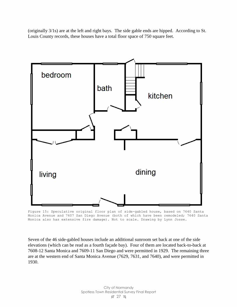
(originally 3/1s) are at the left and right bays. The side gable ends are hipped. According to St.
Louis County records, these houses have a total floor space of 750 square feet.
Seven of the 46 side-gabled houses include an additional sunroom set back at one of the side
elevations (which can be read as a fourth façade bay). Four of them are located back-to-back at
7608-12 Santa Monica and 7609-11 San Diego and were permitted in 1929. The remaining three
are at the western end of Santa Monica Avenue (7629, 7631, and 7640), and were permitted in
1930.
Figure 15: Speculative original floor plan of side-gabled house, based on 7640 Santa
Monica Avenue and 7607 San Diego Avenue (both of which have been remodeled; 7640 Santa
Monica also has extensive fire damage). Not to scale. Drawing by Lynn Josse.
City of Normandy
Spotless Town Residential Survey Final Report 28
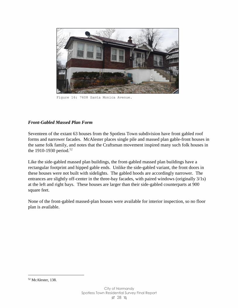
Front-Gabled Massed Plan Form
Seventeen of the extant 63 houses from the Spotless Town subdivision have front gabled roof
forms and narrower facades. McAlester places single pile and massed plan gable-front houses in
the same folk family, and notes that the Craftsman movement inspired many such folk houses in
the 1910-1930 period.52
Like the side-gabled massed plan buildings, the front-gabled massed plan buildings have a
rectangular footprint and hipped gable ends. Unlike the side-gabled variant, the front doors in
these houses were not built with sidelights. The gabled hoods are accordingly narrower. The
entrances are slightly off-center in the three-bay facades, with paired windows (originally 3/1s)
at the left and right bays. These houses are larger than their side-gabled counterparts at 900
square feet.
None of the front-gabled massed-plan houses were available for interior inspection, so no floor
plan is available.
52 McAlester, 138.
Figure 16: 7608 Santa Monica Avenue.
City of Normandy
Spotless Town Residential Survey Final Report 29
Mid-century forms and styles
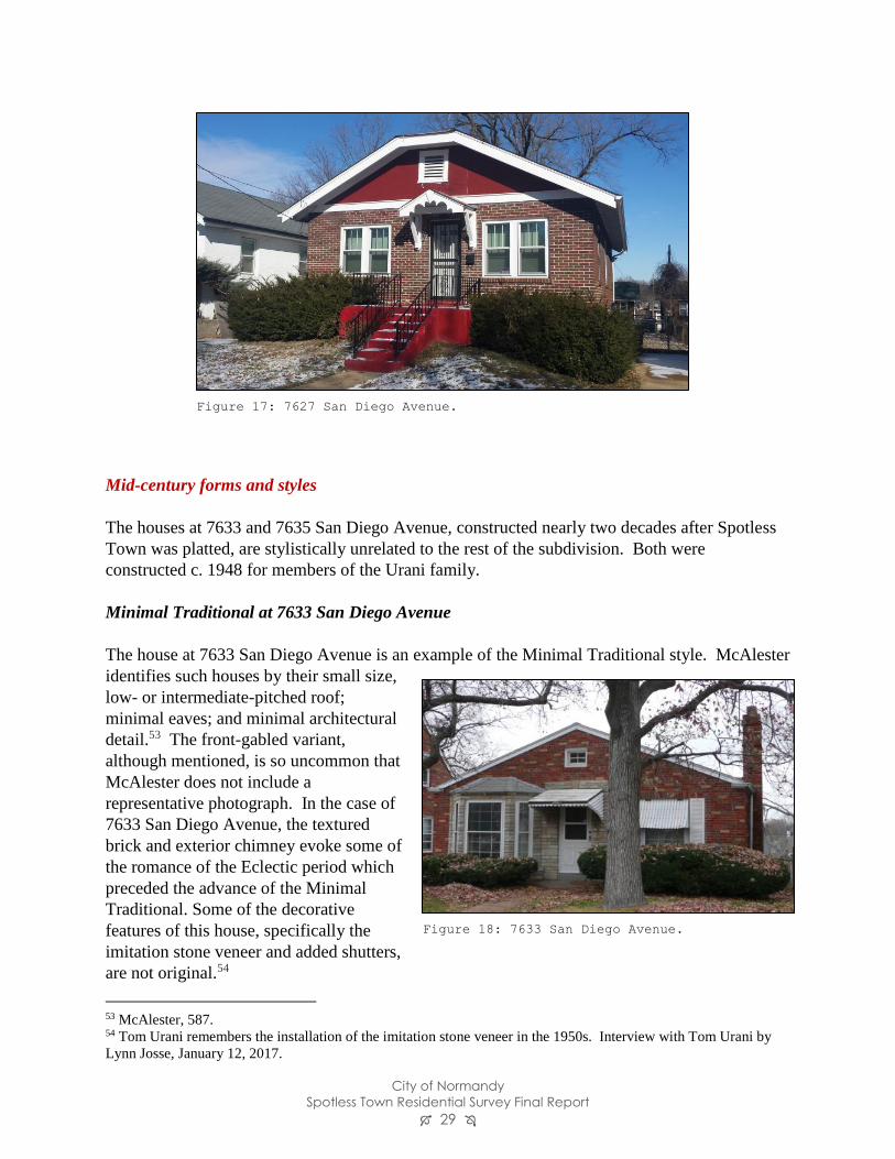
The houses at 7633 and 7635 San Diego Avenue, constructed nearly two decades after Spotless
Town was platted, are stylistically unrelated to the rest of the subdivision. Both were
constructed c. 1948 for members of the Urani family.
Minimal Traditional at 7633 San Diego Avenue
The house at 7633 San Diego Avenue is an example of the Minimal Traditional style. McAlester
identifies such houses by their small size,
low- or intermediate-pitched roof;
minimal eaves; and minimal architectural
detail.53 The front-gabled variant,
although mentioned, is so uncommon that
McAlester does not include a
representative photograph. In the case of
7633 San Diego Avenue, the textured
brick and exterior chimney evoke some of
the romance of the Eclectic period which
preceded the advance of the Minimal
Traditional. Some of the decorative
features of this house, specifically the
imitation stone veneer and added shutters,
are not original.54
53 McAlester, 587. 54 Tom Urani remembers the installation of the imitation stone veneer in the 1950s. Interview with Tom Urani by
Lynn Josse, January 12, 2017.
Figure 17: 7627 San Diego Avenue.
Figure 18: 7633 San Diego Avenue.
City of Normandy
Spotless Town Residential Survey Final Report 30
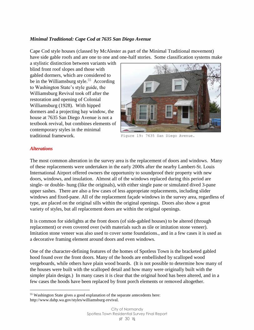
Minimal Traditional: Cape Cod at 7635 San Diego Avenue
Cape Cod style houses (classed by McAlester as part of the Minimal Traditional movement)
have side gable roofs and are one to one and one-half stories. Some classification systems make
a stylistic distinction between variants with
blind front roof slopes and those with
gabled dormers, which are considered to
be in the Williamsburg style.55 According
to Washington State’s style guide, the
Williamsburg Revival took off after the
restoration and opening of Colonial
Williamsburg (1928). With hipped
dormers and a projecting bay window, the
house at 7635 San Diego Avenue is not a
textbook revival, but combines elements of
contemporary styles in the minimal
traditional framework.
Alterations
The most common alteration in the survey area is the replacement of doors and windows. Many
of these replacements were undertaken in the early 2000s after the nearby Lambert-St. Louis
International Airport offered owners the opportunity to soundproof their property with new
doors, windows, and insulation. Almost all of the windows replaced during this period are
single- or double- hung (like the originals), with either single pane or simulated dived 3-pane
upper sashes. There are also a few cases of less appropriate replacements, including slider
windows and fixed-pane. All of the replacement façade windows in the survey area, regardless of
type, are placed on the original sills within the original openings. Doors also show a great
variety of styles, but all replacement doors are within the original openings.
It is common for sidelights at the front doors (of side-gabled houses) to be altered (through
replacement) or even covered over (with materials such as tile or imitation stone veneer).
Imitation stone veneer was also used to cover some foundations., and in a few cases it is used as
a decorative framing element around doors and even windows.
One of the character-defining features of the homes of Spotless Town is the bracketed gabled
hood found over the front doors. Many of the hoods are embellished by scalloped wood
vergeboards, while others have plain wood boards. (It is not possible to determine how many of
the houses were built with the scalloped detail and how many were originally built with the
simpler plain design.) In many cases it is clear that the original hood has been altered, and in a
few cases the hoods have been replaced by front porch elements or removed altogether.
55 Washington State gives a good explanation of the separate antecedents here:
http://www.dahp.wa.gov/styles/williamsburg-revival.
Figure 19: 7635 San Diego Avenue.
City of Normandy
Spotless Town Residential Survey Final Report 31
With only one exception, the brick houses of Spotless Town remain unpainted.
National Register Eligibility
Listing in the National Register of Historic Places is a designation which is conferred on
properties with demonstrated historic significance and which have the integrity to convey that
significance.
Significance
In the development and history of the Spotless Town subdivision are reflected many stories and
themes found in the history of Normandy, the surrounding area, the region, and the country as a
whole. Some of the stories related to the history of the neighborhood include the rise of suburbs
and automobile culture, and the use of the private place strategy to create and maintain a
neighborhood.
To decide if a resource has significance, the National Register instructs us to determine “whether
it [the historic resource] is important in illustrating the historic context.” 56 Again using the
example of suburbanization, it appears that Spotless Town illustrates this context, but from a
National Register of Historic Places perspective, it does not appear to have more importance than
any of its neighbors.
In one area, though, it is possible that Spotless Town may be an important illustration of an
aspect of a significant historic trend. As a private place, Spotless Town was designed to protect
its owners from perceived detriments to the neighborhood by permitting only certain types of
construction, uses, and even neighbors (through the use of race-restrictive language). The use of
private streets and associated restrictions in a distinctly blue collar neighborhood is not a
phenomenon which has been studied before. No context for evaluation has ever been developed.
Additional work on this theme could be accomplished by studying plats and deeds for other
subdivisions.
At this time, then, it appears there is not adequate context on the use of restricted private places
in St. Louis County to determine if Spotless Town possesses the quality of significance under
Criterion A (association with significant events and trends). It does not appear that there is any
basis to claim significance under Criterion B (association with a significant individual), Criterion
C (by embodying the distinctive characteristics of a type, period, or method of construction,
etc.), or Criterion D (potential to yield information – usually used for archeological sites).
56 National Register Bulletin How to Apply the National Register Criteria for Evaluation Section V.

City of Normandy
Spotless Town Residential Survey Final Report 32
Integrity
The National Register defines seven aspects of integrity which must be considered when making
an overall assessment: Materials, workmanship, design, association, setting, feeling, and
location.
Different aspects of integrity are important when considering different areas of significance. For
example, if we were evaluating Spotless Town’s integrity as a representative automobile suburb,
we would look at the physical features of Spotless Town that are associated with the use of the
automobile. It would have to be noted that almost all of the original garages have been
demolished, and as a result, Spotless Town might not be the best candidate to illustrate what an
automobile suburb looked like.
Likewise, if Spotless Town were being considered for its architecture, it would have to be noted
that Lambert Airport paid for window, door, and sidelight replacement in the 1990s-2000s when
it was determined that this was part of the new runway’s flight path. Many (although not all)
owners took advantage of this offer, and as a result there have been significant changes in those
physical features.
In general, Spotless Town can be considered an intact subdivision. All of the houses retain their
primary materials, and only one of the houses has a major addition which impacts the view from
the street (the added fourth bay at 1101 San Bernardino Avenue). According to the National
Register, “the integrity of a historic residential subdivision relies in part on the cohesion of the
historic plan and aspects of spatial organization, including street design, setbacks, and density.”57
These aspects of Spotless Town remain intact.
57 Historic Residential Suburbs, “Evaluation” section.
https://www.nps.gov/nr/publications/bulletins/suburbs/part5.htm

City of Normandy
Spotless Town Residential Survey Final Report 33
Local District Eligibility
To be eligible for consideration as a Normandy local landmark or local historic district, a
building or neighborhood must meet one or more of ten criteria:
a. Significant inherent character, interest or value as part of the development or heritage of
the community, State or nation; or
b. The site of an event significant in history; or
c. Association with a person or persons who contributed significantly to the culture and
development of the community, State or nation; or
d. Exemplifying the cultural, political, economic, social, ethnic or historic heritage of the
community, State or nation; or
e. Individually, or as a collection of resources, embodying distinguishing characteristics of a
type, style, period or specimen in architecture or engineering; or
f. The work of a designer whose work has influenced significantly the development of the
community, State or nation; or
g. Containing elements of design, detail, materials or craftsmanship which represent a
significant innovation; or
h. Part of or related to a distinctive element of community planning; or
i. Representing an established and familiar visual feature of the neighborhood or community;
or
j. Yielding, or may be likely to yield, information important in pre-history or history.58
The criteria are more flexible than those of the National Register of Historic Places,
appropriately allowing the community a great deal of leeway in determining which sites are
representative of its past and worthy of preservation.
At this time, the City of Normandy has not designated any historic districts; as a result, there is
no precedent to indicate how the criteria for designation are to be applied. Spotless Town
appears to meet both of these criteria:
• Significant inherent character, interest or value as part of the development or heritage of
the community, State or nation;
• or Part of or related to a distinctive element of community planning.
58 City of Normandy Code 130.160, available online at http://www.ecode360.com/29148791. Accessed 4/13/2017.

City of Normandy
Spotless Town Residential Survey Final Report 34
Recommendations
With this survey, the City of Normandy has made an excellent first step towards compiling a full
survey of Normandy’s historic resources. These are the recommendations that are being made as
a result of this survey.
National Register Eligibility:
At this time, Spotless Town and its individual resources are not believed to be eligible for listing
in the National Register of Historic Places. Further exploration of the context of private place
development in North St. Louis County or countywide could call for the re-evaluation of
Spotless Town as an example.
Local Historic District Eligibility:
Spotless Town appears to meet at least two criteria for listing as a local historic district. Because
the City of Normandy has not as yet designated any districts, there is no body of work to show
the practical application of the criteria. Spotless Town may possess particular significance to the
City of Normandy as one of the four subdivisions that worked together to gain incorporation in
1945.
Further Research Recommended:
If the Commission is looking for a worthwhile small project to take on, an overview of nearby
subdivisions would be useful. Desirable information to collect would include date of platting,
approximate number of lots, date range of houses constructed (an approximate idea could easily
be garnered from St. Louis County’s web site), and whether the subdivisions were originally
public or private. Such a document could provide valuable context for additional subdivision
surveys.
Further Survey Recommended:
Spotless Town was an interesting starting point in the overall program of identifying
Normandy’s historic resources because of its architectural cohesion and its association with the
incorporation of Normandy in 1945. As a next step, it might make sense to look at the other
subdivisions involved in the incorporation of Normandy (Normandy Heights, Normandy Grove,
and Normandy Place). Alternatively, it would be logical to go to the chronological beginning of
the subdivision of Normandy by studying the subdivisions of Normandy Heights and Oehler’s
Place.
Public Education Projects:
The Historic Preservation Commission is encouraged to use the information contained in this
report to further its educational mission and celebrate the historic resources of Normandy.
Possible uses for this material include brochures, a web page, or tour.
City of Normandy
Spotless Town Residential Survey Final Report 35
Bibliography
Guidance for conducting surveys and evaluating resources
City of Normandy Code (Chapter 130). http://www.ecode360.com/29148791 , accessed
3/21/2017.
Missouri State Historic Preservation Office Standards for Professional Architectural and Historic
Surveys: http://dnr.mo.gov/shpo/minsurvgl.htm, accessed 3/21/2017.
National Register of Historic Places. Guidelines for Local Surveys: A Basis for Preservation
Planning (Bulletin 24). https://www.nps.gov/nr/publications/bulletins/nrb24/, accessed
3/21/2017.
National Register of Historic Places Bulletin. Historic Residential Suburbs.
https://www.nps.gov/nr/publications/bulletins/suburbs/index.htm, accessed 3/21/2017.
National Register of Historic Places. How to Apply the National Register Criteria for Evaluation
(Bulletin 15). https://www.nps.gov/nr/publications/bulletins/nrb15/, accessed 3/21/2017.
Sources Consulted
“24 New Bungalows are Put on Market,” St. Louis Star, November 15, 1928, 25.
“Asserts Funds Apparently Went to Gilpin’s Personal Use.” St. Louis Post-Dispatch. January 5,
1956. 1.
An Atlas of St. Louis County in the State of Missouri, 1893. Clayton, Missouri: C. R. Black,
1893.
Baxter, Karen Bode, et al, “Pasadena Hills Historic District” National Register nomination, listed
12/04/2004.
Bureau of Land Management patent records. https://glorecords.blm.gov accessed March 21,
2017.
Classified advertisement. St. Louis Post-Dispatch, August 7, 1931. 31.
City of Normandy
Spotless Town Residential Survey Final Report 36
Gill, Bob. “Crossroads: Memories of the Normandy Wedge.” Normandy Area Historical
Association. n. d. http://www.cityofnormandy.gov/DocumentCenter/Home/View/582 ,
accessed 3/21/2017.
Davison, Rosemary. Rail, Mail & Dreams. Historic Florissant, Inc, 2009.
Derrington, Lindsey et al. “Wellston Loop Commercial Historic District” National Register
nomination, listed 9/9/2010.
“Early Transportation St. Louis City and County” in “History of Normandy” document, dated
September 1973. Missouri Historical Society Archives., 13
Foley, William E. Wilderness Journey: The Life of William Clark. Columbia, Missouri:
University of Missouri Press, 2004.
“Gilpin Accused of Transfers of Firm Property.” St. Louis Post-Dispatch. January 26, 1956. 1.
Hamilton, Esley. “Hampton Park Historic District” National Register nomination, listed
12/21/2005.
Esley Hamilton. Interviewed by Lynn Josse, January 3, 2017.
Harris, NiNi and Lynn Josse. “Holly Hills Historic District” National Register nomination, listed
March 22, 2016.
“History of Normandy” document, dated September 1973. Missouri Historical Society Archives.
Hutawa, Edward. Atlas of the county of St. Louis, Missouri. 1847.
Josse, Lynn. “Waterman Place/Kingsbury Place/Washington Terrace Historic District” National
Register nomination, listed 6/12/2007.
“Know Your County: Normandy,” St. Louis Star-Times, February 23, 1946.
McAlester, Virginia Savage. A Field Guide to American Houses 2nd ed. New York: Alfred A.
Knopf, 2014.
Missouri Secretary of State Death Certificates,
http://www.sos.mo.gov/images/archives/deathcerts/1949/1949_00025686.PDF, accessed
March 4, 2017.
“Normandy District to File Petition for Incorporation.” St. Louis Post-Dispatch. 3/21/1945. 10B.
City of Normandy
Spotless Town Residential Survey Final Report 37
“Normandy Home Wrecked by Unexplained Explosion.” St. Louis Post-Dispatch. January 6,
1933. 11A.
“Opening of Spotless Town” advertisement. St. Louis Post-Dispatch. September 8, 1929. 11B.
Penick, James L. The New Madrid Earthquakes revised edition. Columbia, Missouri: University
of Missouri Press, 1981.
Polk’s St. Louis County Directory. 1930 through 1971-72.
Primm, James Neal. Lion of the Valley 3rd ed. Saint Louis: Missouri Historical Society Press,
1998.
Saint Louis County web site. Jurisdictions map:
http://www.stlouisco.com/Portals/8/docs/Document%20Library/Public%20Works/code%
20enforcement/Maps/Munis-color.pdf accessed March 20, 2017.
“Radio Bungalow Co.” advertisement. St. Louis Star, June 2, 1928. 7.
St. Louis County Recorder of Deeds office; Deed Indexes for 1929-1931.
St. Louis Daily Record “Building News” section. Various dates, 1929-1931.
“St. Louis Prize Recipes” column. St. Louis Star-Times. September 23, 1948. 23.
Sanborn Map Company, Sanborn Maps of St. Louis. Volume 16 index page, 1951.
Sapolio advertisement. Colliers Weekly vol. 27 no. 9, June 1, 1901. 12.
Savage, Charles C. Architecture of the Private Streets of St. Louis. Columbia, Missouri:
University of Missouri Press, 1987.
Sivulka, Juliann. Soap, Sex, and Cigarettes: A Cultural History of American Advertising 2nd ed.
Boston: Wadsworth, 2012.
“Sol Loewenstein.” Death Notices, St. Louis Post-Dispatch. June 7, 1949. 26.
“Spotless Town Advertising” letter to the editor, Printers’ Ink v. 106 No. 2, January 9, 1919. 48
“Spotless Town” plat, St. Louis County Recorder of Deeds, plat book 28 page 20.
“Spotless Town Addition” plat. St. Louis County Recorder of Deeds, plat book 26 page 61.
“Store Building in Normandy Bought by one of Occupants,” St. Louis Post-Dispatch. April 16,
1944. 1C.
City of Normandy
Spotless Town Residential Survey Final Report 38
United States Census. Fourteenth Census of the United States: 1920. Population Schedules.
United States Census. Fifteenth Census of the United States: 1930. Population Schedules.
United States Census: Sixteenth Census of the United States: 1940. Population Schedules.
United State Geological Survey. Saint Louis Quadrangle map, Missouri-Illinois. Washington:
Department of the Interior, U.S. Geological Survey, 1904. University of Alabama Map
Library http://alabamamaps.ua.edu/historicalmaps/us_states/missouri/StLouis.html
accessed 3/10/2017.
Urani, Tom. Interviewed by Lynn Josse, January 12, 2017.
Washington State Department of Archaeology & Historic Preservation.
http://www.dahp.wa.gov/styles/williamsburg-revival. Accessed 3/31/2017.
Watkins, Julian Lewis. The 100 Greatest Advertisements 1852-1958: Who Wrote Them and What
They Did. Dover reprint, 1993.
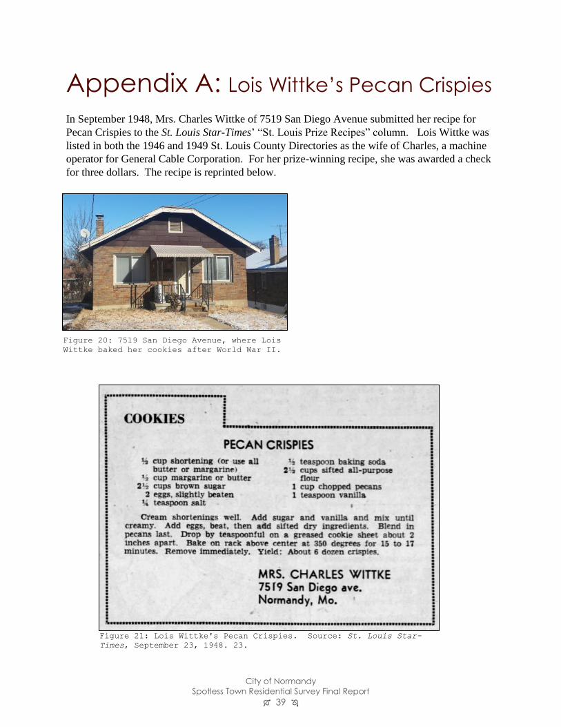
City of Normandy
Spotless Town Residential Survey Final Report 39
Appendix A: Lois Wittke’s Pecan Crispies
In September 1948, Mrs. Charles Wittke of 7519 San Diego Avenue submitted her recipe for
Pecan Crispies to the St. Louis Star-Times’ “St. Louis Prize Recipes” column. Lois Wittke was
listed in both the 1946 and 1949 St. Louis County Directories as the wife of Charles, a machine
operator for General Cable Corporation. For her prize-winning recipe, she was awarded a check
for three dollars. The recipe is reprinted below.
Figure 21: Lois Wittke's Pecan Crispies. Source: St. Louis Star-
Times, September 23, 1948. 23.
Figure 20: 7519 San Diego Avenue, where Lois
Wittke baked her cookies after World War II.