Embed Size (px)
Citation preview

Site: Mandalong Title: Mandalong Extraction Plan LW30-31 Environment Stature ID:1001284063 Version: 1 Lifecycle State:
1 of 21
Stature for Risk Management Administration: Risk Assessment Title: Mandalong Extraction Plan LW30-31 Environment Revision: 1 Region: North Site: Mandalong Department: ZZZZ Whole Site Equipment / Process: Community Stature Risk Assessment No.: 1001284063 Study Lifecycle State: Risk Assessment in Progress Potential Hazard No.: PULSE Actions Required URL: Site Risk Assessment Ref. No. (Optional):
1. Background An Extraction Plan is required by the Department of Planning Industry and Environment as specified Development Consent SSD-5144 and Mining Lease conditions. This Risk Assessment will identify and manage the risks associated with subsidence caused by the extraction for LW30-31 on the environment. Subsidence prediction and assessment of impacts for LW30-31 Extraction Plan has been conducted by Ditton Geotechnical Services (DgS). The predictions method is based on the DgS modified ACARP 2003 subsidence model and subsidence effects data from Mandalong Mine LW1 to 27. The reliability of the subsidence model has been assessed using regression analysis techniques and estimates of the mean and standard deviation (error) of the data set. The mean subsidence predictions represent the expected subsidence and the Upper 95% Confidence Limits represents the worst-case subsidence effects.

Site: Mandalong Title: Mandalong Extraction Plan LW30-31 Environment Stature ID:1001284063 Version: 1 Lifecycle State:
2 of 21
2. Objective The following Hierarchy of Controls offers a framework for considering the effectiveness of controls. Note that the effectiveness of a control that is intended to reduce a risk decreases from top to bottom of the list. In other words, the closer the control type is to the top of the hierarchy, the more potentially effective the control. ·Eliminate the hazard or energy source (do not use the energy) ·Minimise or replace the hazard or energy source (reduce the amount of energy to a less damaging level or replace the energy with another that has less potential negative consequences) ·Control the hazard or energy using engineered devices (ex. Lock outs, chemical containers, mechanical roof support, gas monitors, etc.) ·Control the hazard or energy by using physical barriers (ex. machine guarding, fences or enclosures, etc.) ·Control the hazard or energy with procedures (ex. Isolation procedures, standard operating procedures, etc.) ·Control the hazard or energy with personal protective equipment (ex. hard hats, boots with toe caps, gloves, safety glasses, welding gear, etc.) ·Control the hazard or energy with warnings and awareness (ex. posters, labels, warning signs, verbal warnings, etc.) To identify, assess and control the risks to the environment caused by mining longwall blocks 30-31
3. Potential Hazards Predicted subsidence and Subsidence at the worst- case, Upper 95% Confidence Limits
4. Risk Assessment Boundary Definition Extraction of LW30-31
Site: Mandalong Title: Mandalong Extraction Plan LW30-31 Environment Stature ID:1001284063 Version: 1 Lifecycle State:
3 of 21
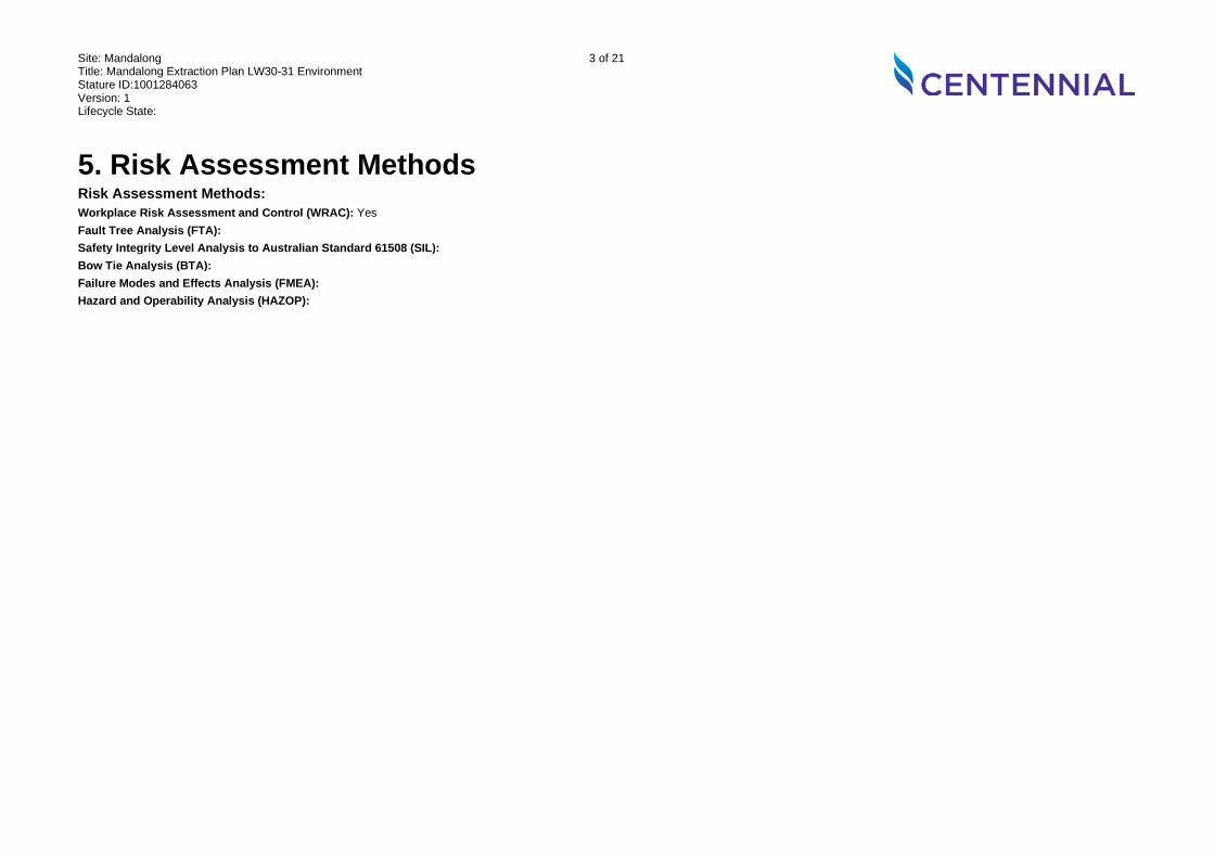
5. Risk Assessment Methods Risk Assessment Methods: Workplace Risk Assessment and Control (WRAC): Yes Fault Tree Analysis (FTA): Safety Integrity Level Analysis to Australian Standard 61508 (SIL): Bow Tie Analysis (BTA): Failure Modes and Effects Analysis (FMEA): Hazard and Operability Analysis (HAZOP):

Site: Mandalong Title: Mandalong Extraction Plan LW30-31 Environment Stature ID:1001284063 Version: 1 Lifecycle State:
4 of 21
6. Previous Risk Assessment and other documents to be used and/or referenced
Document Name Title Version Referenced Document Date Subsidence Prediction and Impact Assessment LW30-31, MAN-005/2 (Ditton Geotechnical Services, 2021)
Flood Assessment Longwalls 1 to 33 (Umwelt, 2020)
Extraction Plan LW25-31 - Water Management Plan (GHD, 2018)
Extraction Plan LW25-31 - Biodiversity Management Plan (RPS, 2018)
Extraction Plan LW25-31 - Heritage Management Plan (RPS, 2018)
Extraction Plan LW25-31 - Land Management Plan (Centennial Mandalong, 2018)
Extraction Plan LW30-LW33 Land and Agricultural Resource Assessment (SLR, 2020)
Managing Risk of Subsidence, Guide: WHS (Mines and Petroleum Sites Legislation) (NSW Department of Industry - Resources Regulator, 2017)
Development Consent SSD-5144
Draft Guidelines for the Preparation of Extraction Plans V5
Plans MG14065 and MG14066 Proposed workings LW30-31 - surface features and infrastructure
EIS Mandalong Southern Extension Project
Site: Mandalong Title: Mandalong Extraction Plan LW30-31 Environment Stature ID:1001284063 Version: 1 Lifecycle State:
5 of 21
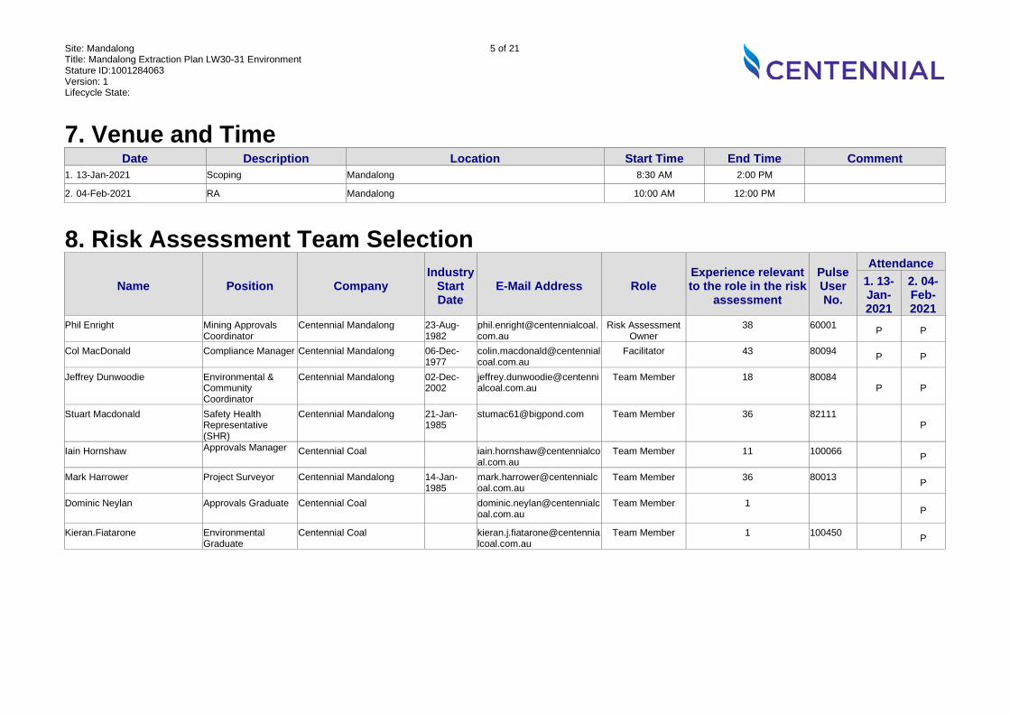
7. Venue and Time Date Description Location Start Time End Time Comment
1. 13-Jan-2021
Scoping Mandalong 8:30 AM 2:00 PM
2. 04-Feb-2021
RA Mandalong 10:00 AM 12:00 PM
8. Risk Assessment Team Selection Name Position Company
Industry Start Date
E-Mail Address Role Experience relevant to the role in the risk
assessment
Pulse User No.
Attendance 1. 13-Jan-2021
2. 04-Feb-2021
Phil Enright Mining Approvals Coordinator
Centennial Mandalong 23-Aug-1982
Risk Assessment Owner
38 60001 P P
Col MacDonald Compliance Manager Centennial Mandalong 06-Dec-1977
Facilitator 43 80094 P P
Jeffrey Dunwoodie Environmental & Community Coordinator
Centennial Mandalong 02-Dec-2002
Team Member 18 80084 P P
Stuart Macdonald Safety Health Representative (SHR)
Centennial Mandalong 21-Jan-1985
[email protected] Team Member 36 82111 P
Iain Hornshaw Approvals Manager Centennial Coal [email protected]
Team Member 11 100066 P
Mark Harrower Project Surveyor Centennial Mandalong 14-Jan-1985
Team Member 36 80013 P
Dominic Neylan Approvals Graduate Centennial Coal [email protected]
Team Member 1 P
Kieran.Fiatarone Environmental Graduate
Centennial Coal [email protected]
Team Member 1 100450 P

Site: Mandalong Title: Mandalong Extraction Plan LW30-31 Environment Stature ID:1001284063 Version: 1 Lifecycle State:
6 of 21
WRAC Analysis Worksheet Step Potential Incident Current Controls L MR
C RR Recommended Control Bow Tie
Extension
1. Surface Water There is a risk to Mandalong from ::: Predicted subsidence affecting surface water ::: Caused by: ▪ Expected geotechnical conditions Resulting in: ▪ alter flow conveyance capacity ▪ changes to flood regime ▪ channel realignment ▪ localised channel instability ▪ ponding.
1.1.a. Mine design providing low levels of subsidence
D (D)
1 (E)
2 (L)
1.1.b. Surface and underground exploration programs to determine geotechnical conditions 1.1.c. DgS Report - Subsidence Prediction and Impact Assessment 1.1.d. Flood modelling and assessment 1.1.e. Potential remnant ponding locations identified in flood modelling and assessment 1.1.f. Water Management Plan 1.1.g. Potential changes to surface water is documented and managed in PSMPs 1.1.h. Floodpath inspections are conducted twice per year and after flood events 1.1.i. Subsidence monitoring along Morans Creek and tributary
There is a risk to Mandalong from ::: Subsidence at the worst- case, Upper 95% Confidence Limits affecting surface water ::: Caused by: ▪ Geotechnical conditions worse than anticipated Resulting in: ▪ alter flow conveyance capacity ▪ changes to flood regime ▪ channel realignment ▪ localised channel instability ▪ ponding.
1.2.a. Mine design providing low levels of subsidence
D (D)
1 (E)
2 (L)
1.2.b. Surface and underground exploration programs to determine geotechnical conditions 1.2.c. DgS Report - Subsidence Prediction and Impact Assessment 1.2.d. Flood modelling and assessment 1.2.e. Flood modelling based on maximum subsidence predictions at Upper 95% confidence limits 1.2.f. Potential remnant ponding locations identified in flood modelling and assessment 1.2.g. Water Management Plan 1.2.h. Potential changes to surface water is

Site: Mandalong Title: Mandalong Extraction Plan LW30-31 Environment Stature ID:1001284063 Version: 1 Lifecycle State:
7 of 21
Step Potential Incident Current Controls L MRC RR Recommended Control
Bow Tie
Extension
documented and managed in PSMPs 1.2.i. Floodpath inspections are conducted twice per year and after flood events 1.2.j. Subsidence monitoring along Morans Creek and tributary
2. Groundwater There is a risk to Mandalong from ::: predicted subsidence affecting alluvial groundwater ::: Caused by: ▪ Expected geotechnical conditions Resulting in: ▪ change in alluvial groundwater quality (pH and EC) ▪ decline in alluvial groundwater level.
2.1.a. Mine design providing low levels of subsidence
D (D)
1 (E)
2 (L)
2.1.b. Alluvial aquifer located above massive conglomerate and sandstone strata, with no connective cracking to mine workings. 2.1.c. DgS Report - Subsidence Prediction and Impact Assessment 2.1.d. Groundwater bore monitoring network and quarterly sampling for water level and quality 2.1.e. Groundwater bores adjacent Extraction Plan Area 2.1.f. Water Management Plan 2.1.g. Extraction outside the alluvial floodplain.
There is a risk to Mandalong from ::: Subsidence at the worst- case, Upper 95% Confidence Limits affecting alluvial groundwater ::: Caused by: ▪ Geotechnical conditions worse than anticipated Resulting in: ▪ change in alluvial groundwater quality (pH and EC) ▪ decline in alluvial groundwater level.
2.2.a. Extraction outside the alluvial floodplain.
D (D)
1 (E)
2 (L)
2.2.b. Mine design providing low levels of subsidence 2.2.c. Alluvial aquifer located above massive conglomerate and sandstone strata, with no connective cracking to mine workings. 2.2.d. DgS Report - Subsidence Prediction and Impact Assessment 2.2.e. Groundwater bore monitoring network and quarterly sampling for water level and quality 2.2.f. Groundwater bores adjacent Extraction Plan Area 2.2.g. Water Management Plan
Site: Mandalong Title: Mandalong Extraction Plan LW30-31 Environment Stature ID:1001284063 Version: 1 Lifecycle State:
8 of 21
Step Potential Incident Current Controls L MRC RR Recommended Control
Bow Tie
Extension
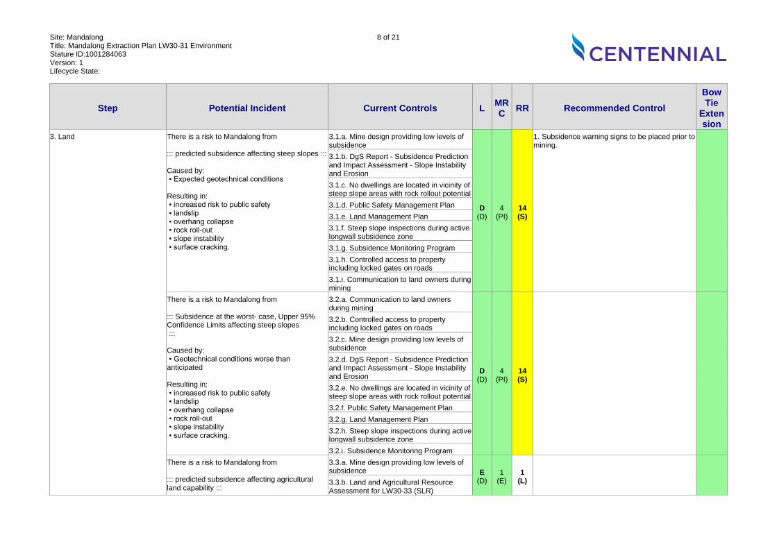
3. Land There is a risk to Mandalong from ::: predicted subsidence affecting steep slopes ::: Caused by: ▪ Expected geotechnical conditions Resulting in: ▪ increased risk to public safety ▪ landslip ▪ overhang collapse ▪ rock roll-out ▪ slope instability ▪ surface cracking.
3.1.a. Mine design providing low levels of subsidence
D (D)
4 (PI)
14 (S)
1. Subsidence warning signs to be placed prior to mining.
3.1.b. DgS Report - Subsidence Prediction and Impact Assessment - Slope Instability and Erosion 3.1.c. No dwellings are located in vicinity of steep slope areas with rock rollout potential 3.1.d. Public Safety Management Plan 3.1.e. Land Management Plan 3.1.f. Steep slope inspections during active longwall subsidence zone 3.1.g. Subsidence Monitoring Program 3.1.h. Controlled access to property including locked gates on roads 3.1.i. Communication to land owners during mining
There is a risk to Mandalong from ::: Subsidence at the worst- case, Upper 95% Confidence Limits affecting steep slopes ::: Caused by: ▪ Geotechnical conditions worse than anticipated Resulting in: ▪ increased risk to public safety ▪ landslip ▪ overhang collapse ▪ rock roll-out ▪ slope instability ▪ surface cracking.
3.2.a. Communication to land owners during mining
D (D)
4 (PI)
14 (S)
3.2.b. Controlled access to property including locked gates on roads 3.2.c. Mine design providing low levels of subsidence 3.2.d. DgS Report - Subsidence Prediction and Impact Assessment - Slope Instability and Erosion 3.2.e. No dwellings are located in vicinity of steep slope areas with rock rollout potential 3.2.f. Public Safety Management Plan 3.2.g. Land Management Plan 3.2.h. Steep slope inspections during active longwall subsidence zone 3.2.i. Subsidence Monitoring Program
There is a risk to Mandalong from ::: predicted subsidence affecting agricultural land capability :::
3.3.a. Mine design providing low levels of subsidence E
(D) 1
(E) 1
(L)
3.3.b. Land and Agricultural Resource Assessment for LW30-33 (SLR)

Site: Mandalong Title: Mandalong Extraction Plan LW30-31 Environment Stature ID:1001284063 Version: 1 Lifecycle State:
9 of 21
Step Potential Incident Current Controls L MRC RR Recommended Control
Bow Tie
Extension
Caused by: ▪ Expected geotechnical conditions Resulting in: ▪ impact on agricultural land use.
3.3.c. Flood modelling and assessment 3.3.d. Potential remnant ponding locations identified in flood modelling and assessment 3.3.e. Land Management Plan 3.3.f. Property Subsidence Management Plans 3.3.g. Land and Soil Capability - Class 5 and 7 3.3.h. Minimal domestic agriculture 3.3.i. No BSAL within Extraction Plan Area
There is a risk to Mandalong from ::: Subsidence at the worst- case, Upper 95% Confidence Limits affecting agricultural land capability ::: Caused by: ▪ Geotechnical conditions worse than anticipated Resulting in: ▪ impact on agricultural land use.
3.4.a. Minimal domestic agriculture
E (D)
1 (E)
1 (L)
3.4.b. Land and Soil Capability - Class 5 and 7 3.4.c. Mine design providing low levels of subsidence 3.4.d. Land and Agricultural Resource Assessment for LW30-33 (SLR) 3.4.e. Flood modelling and assessment 3.4.f. Potential remnant ponding locations identified in flood modelling and assessment 3.4.g. No BSAL within Extraction Plan Area 3.4.h. Property Subsidence Management Plans
There is a risk to Mandalong from ::: predicted subsidence increasing erosion potential ::: Caused by: ▪ Expected geotechnical conditions Resulting in: ▪ increased extent of tunnel erosion ▪ land damage by erosion.
3.5.a. Mine design providing low levels of subsidence
D (Op)
1 (E)
2 (L)
3.5.b. Land and Agricultural Resource Assessment for LW30-33 (SLR) 3.5.c. Flood modelling and assessment 3.5.d. Minimal remnant ponding locations identified in flood modelling and assessment 3.5.e. No BSAL within Extraction Plan Area 3.5.f. Land Management Plan
Site: Mandalong Title: Mandalong Extraction Plan LW30-31 Environment Stature ID:1001284063 Version: 1 Lifecycle State:
10 of 21
Step Potential Incident Current Controls L MRC RR Recommended Control
Bow Tie
Extension
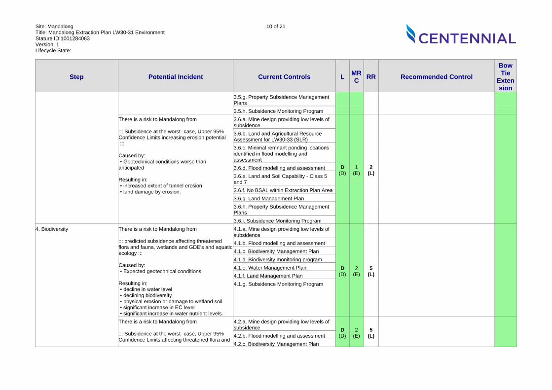
3.5.g. Property Subsidence Management Plans 3.5.h. Subsidence Monitoring Program
There is a risk to Mandalong from ::: Subsidence at the worst- case, Upper 95% Confidence Limits increasing erosion potential ::: Caused by: ▪ Geotechnical conditions worse than anticipated Resulting in: ▪ increased extent of tunnel erosion ▪ land damage by erosion.
3.6.a. Mine design providing low levels of subsidence
D (D)
1 (E)
2 (L)
3.6.b. Land and Agricultural Resource Assessment for LW30-33 (SLR) 3.6.c. Minimal remnant ponding locations identified in flood modelling and assessment 3.6.d. Flood modelling and assessment 3.6.e. Land and Soil Capability - Class 5 and 7 3.6.f. No BSAL within Extraction Plan Area 3.6.g. Land Management Plan 3.6.h. Property Subsidence Management Plans 3.6.i. Subsidence Monitoring Program
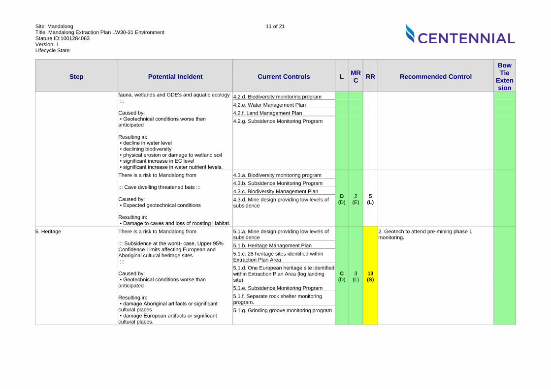
4. Biodiversity There is a risk to Mandalong from ::: predicted subsidence affecting threatened flora and fauna, wetlands and GDE's and aquatic ecology ::: Caused by: ▪ Expected geotechnical conditions Resulting in: ▪ decline in water level ▪ declining biodiversity ▪ physical erosion or damage to wetland soil ▪ significant increase in EC level ▪ significant increase in water nutrient levels.
4.1.a. Mine design providing low levels of subsidence
D (D)
2 (E)
5 (L)
4.1.b. Flood modelling and assessment 4.1.c. Biodiversity Management Plan 4.1.d. Biodiversity monitoring program 4.1.e. Water Management Plan 4.1.f. Land Management Plan 4.1.g. Subsidence Monitoring Program
There is a risk to Mandalong from ::: Subsidence at the worst- case, Upper 95% Confidence Limits affecting threatened flora and
4.2.a. Mine design providing low levels of subsidence D
(D) 2
(E) 5
(L)
4.2.b. Flood modelling and assessment 4.2.c. Biodiversity Management Plan
Site: Mandalong Title: Mandalong Extraction Plan LW30-31 Environment Stature ID:1001284063 Version: 1 Lifecycle State:
11 of 21
Step Potential Incident Current Controls L MRC RR Recommended Control
Bow Tie
Extension
fauna, wetlands and GDE's and aquatic ecology ::: Caused by: ▪ Geotechnical conditions worse than anticipated Resulting in: ▪ decline in water level ▪ declining biodiversity ▪ physical erosion or damage to wetland soil ▪ significant increase in EC level ▪ significant increase in water nutrient levels.
4.2.d. Biodiversity monitoring program 4.2.e. Water Management Plan 4.2.f. Land Management Plan 4.2.g. Subsidence Monitoring Program
There is a risk to Mandalong from ::: Cave dwelling threatened bats ::: Caused by: ▪ Expected geotechnical conditions Resulting in: ▪ Damage to caves and loss of roosting Habitat.
4.3.a. Biodiversity monitoring program
D (D)
2 (E)
5 (L)
4.3.b. Subsidence Monitoring Program 4.3.c. Biodiversity Management Plan 4.3.d. Mine design providing low levels of subsidence
5. Heritage There is a risk to Mandalong from ::: Subsidence at the worst- case, Upper 95% Confidence Limits affecting European and Aboriginal cultural heritage sites ::: Caused by: ▪ Geotechnical conditions worse than anticipated Resulting in: ▪ damage Aboriginal artifacts or significant cultural places ▪ damage European artifacts or significant cultural places.
5.1.a. Mine design providing low levels of subsidence
C (D)
3 (L)
13 (S)
2. Geotech to attend pre-mining phase 1 monitoring.
5.1.b. Heritage Management Plan 5.1.c. 28 heritage sites identified within Extraction Plan Area 5.1.d. One European heritage site identified within Extraction Plan Area (log landing site) 5.1.e. Subsidence Monitoring Program 5.1.f. Separate rock shelter monitoring program. 5.1.g. Grinding groove monitoring program
Site: Mandalong Title: Mandalong Extraction Plan LW30-31 Environment Stature ID:1001284063 Version: 1 Lifecycle State:
12 of 21
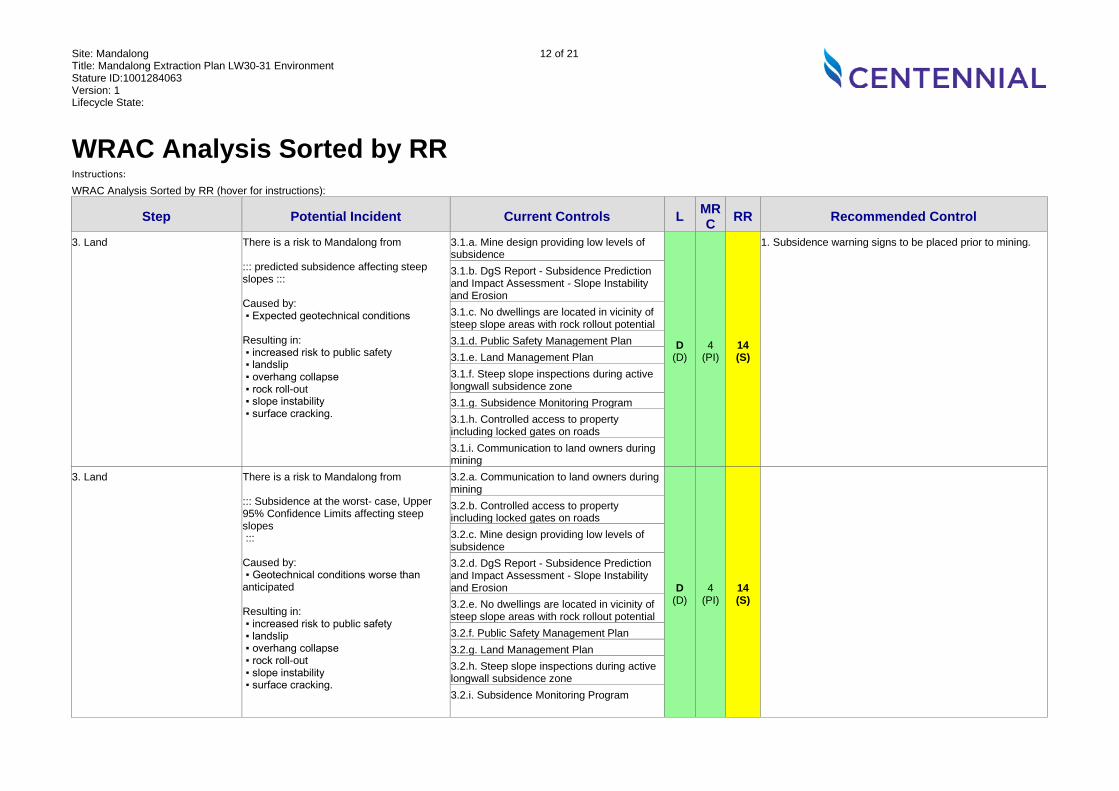
WRAC Analysis Sorted by RR Instructions:
WRAC Analysis Sorted by RR (hover for instructions):
Step Potential Incident Current Controls L MRC RR Recommended Control
3. Land There is a risk to Mandalong from ::: predicted subsidence affecting steep slopes ::: Caused by: ▪ Expected geotechnical conditions Resulting in: ▪ increased risk to public safety ▪ landslip ▪ overhang collapse ▪ rock roll-out ▪ slope instability ▪ surface cracking.
3.1.a. Mine design providing low levels of subsidence
D (D)
4 (PI)
14 (S)
1. Subsidence warning signs to be placed prior to mining.
3.1.b. DgS Report - Subsidence Prediction and Impact Assessment - Slope Instability and Erosion 3.1.c. No dwellings are located in vicinity of steep slope areas with rock rollout potential 3.1.d. Public Safety Management Plan 3.1.e. Land Management Plan 3.1.f. Steep slope inspections during active longwall subsidence zone 3.1.g. Subsidence Monitoring Program 3.1.h. Controlled access to property including locked gates on roads 3.1.i. Communication to land owners during mining
3. Land There is a risk to Mandalong from ::: Subsidence at the worst- case, Upper 95% Confidence Limits affecting steep slopes ::: Caused by: ▪ Geotechnical conditions worse than anticipated Resulting in: ▪ increased risk to public safety ▪ landslip ▪ overhang collapse ▪ rock roll-out ▪ slope instability ▪ surface cracking.
3.2.a. Communication to land owners during mining
D (D)
4 (PI)
14 (S)
3.2.b. Controlled access to property including locked gates on roads 3.2.c. Mine design providing low levels of subsidence 3.2.d. DgS Report - Subsidence Prediction and Impact Assessment - Slope Instability and Erosion 3.2.e. No dwellings are located in vicinity of steep slope areas with rock rollout potential 3.2.f. Public Safety Management Plan 3.2.g. Land Management Plan 3.2.h. Steep slope inspections during active longwall subsidence zone 3.2.i. Subsidence Monitoring Program
Site: Mandalong Title: Mandalong Extraction Plan LW30-31 Environment Stature ID:1001284063 Version: 1 Lifecycle State:
13 of 21
Instructions:
WRAC Analysis Sorted by RR (hover for instructions):
Step Potential Incident Current Controls L MRC RR Recommended Control
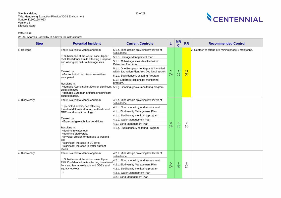
5. Heritage There is a risk to Mandalong from ::: Subsidence at the worst- case, Upper 95% Confidence Limits affecting European and Aboriginal cultural heritage sites ::: Caused by: ▪ Geotechnical conditions worse than anticipated Resulting in: ▪ damage Aboriginal artifacts or significant cultural places ▪ damage European artifacts or significant cultural places.
5.1.a. Mine design providing low levels of subsidence
C (D)
3 (L)
13 (S)
2. Geotech to attend pre-mining phase 1 monitoring.
5.1.b. Heritage Management Plan 5.1.c. 28 heritage sites identified within Extraction Plan Area 5.1.d. One European heritage site identified within Extraction Plan Area (log landing site) 5.1.e. Subsidence Monitoring Program 5.1.f. Separate rock shelter monitoring program. 5.1.g. Grinding groove monitoring program
4. Biodiversity There is a risk to Mandalong from ::: predicted subsidence affecting threatened flora and fauna, wetlands and GDE's and aquatic ecology ::: Caused by: ▪ Expected geotechnical conditions Resulting in: ▪ decline in water level ▪ declining biodiversity ▪ physical erosion or damage to wetland soil ▪ significant increase in EC level ▪ significant increase in water nutrient levels.
4.1.a. Mine design providing low levels of subsidence
D (D)
2 (E)
5 (L)
4.1.b. Flood modelling and assessment 4.1.c. Biodiversity Management Plan 4.1.d. Biodiversity monitoring program 4.1.e. Water Management Plan 4.1.f. Land Management Plan 4.1.g. Subsidence Monitoring Program
4. Biodiversity There is a risk to Mandalong from ::: Subsidence at the worst- case, Upper 95% Confidence Limits affecting threatened flora and fauna, wetlands and GDE's and aquatic ecology :::
4.2.a. Mine design providing low levels of subsidence
D (D)
2 (E)
5 (L)
4.2.b. Flood modelling and assessment 4.2.c. Biodiversity Management Plan 4.2.d. Biodiversity monitoring program 4.2.e. Water Management Plan 4.2.f. Land Management Plan
Site: Mandalong Title: Mandalong Extraction Plan LW30-31 Environment Stature ID:1001284063 Version: 1 Lifecycle State:
14 of 21
Instructions:
WRAC Analysis Sorted by RR (hover for instructions):
Step Potential Incident Current Controls L MRC RR Recommended Control
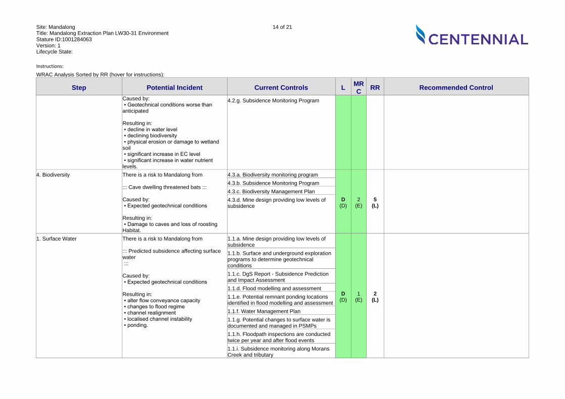
Caused by: ▪ Geotechnical conditions worse than anticipated Resulting in: ▪ decline in water level ▪ declining biodiversity ▪ physical erosion or damage to wetland soil ▪ significant increase in EC level ▪ significant increase in water nutrient levels.
4.2.g. Subsidence Monitoring Program
4. Biodiversity There is a risk to Mandalong from ::: Cave dwelling threatened bats ::: Caused by: ▪ Expected geotechnical conditions Resulting in: ▪ Damage to caves and loss of roosting Habitat.
4.3.a. Biodiversity monitoring program
D (D)
2 (E)
5 (L)
4.3.b. Subsidence Monitoring Program 4.3.c. Biodiversity Management Plan 4.3.d. Mine design providing low levels of subsidence
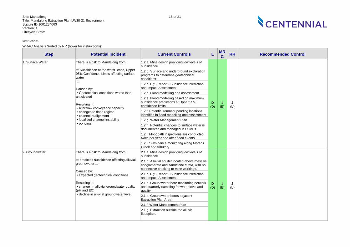
1. Surface Water There is a risk to Mandalong from ::: Predicted subsidence affecting surface water ::: Caused by: ▪ Expected geotechnical conditions Resulting in: ▪ alter flow conveyance capacity ▪ changes to flood regime ▪ channel realignment ▪ localised channel instability ▪ ponding.
1.1.a. Mine design providing low levels of subsidence
D (D)
1 (E)
2 (L)
1.1.b. Surface and underground exploration programs to determine geotechnical conditions 1.1.c. DgS Report - Subsidence Prediction and Impact Assessment 1.1.d. Flood modelling and assessment 1.1.e. Potential remnant ponding locations identified in flood modelling and assessment 1.1.f. Water Management Plan 1.1.g. Potential changes to surface water is documented and managed in PSMPs 1.1.h. Floodpath inspections are conducted twice per year and after flood events 1.1.i. Subsidence monitoring along Morans Creek and tributary
Site: Mandalong Title: Mandalong Extraction Plan LW30-31 Environment Stature ID:1001284063 Version: 1 Lifecycle State:
15 of 21
Instructions:
WRAC Analysis Sorted by RR (hover for instructions):
Step Potential Incident Current Controls L MRC RR Recommended Control
1. Surface Water There is a risk to Mandalong from ::: Subsidence at the worst- case, Upper 95% Confidence Limits affecting surface water ::: Caused by: ▪ Geotechnical conditions worse than anticipated Resulting in: ▪ alter flow conveyance capacity ▪ changes to flood regime ▪ channel realignment ▪ localised channel instability ▪ ponding.
1.2.a. Mine design providing low levels of subsidence
D (D)
1 (E)
2 (L)
1.2.b. Surface and underground exploration programs to determine geotechnical conditions 1.2.c. DgS Report - Subsidence Prediction and Impact Assessment 1.2.d. Flood modelling and assessment 1.2.e. Flood modelling based on maximum subsidence predictions at Upper 95% confidence limits 1.2.f. Potential remnant ponding locations identified in flood modelling and assessment 1.2.g. Water Management Plan 1.2.h. Potential changes to surface water is documented and managed in PSMPs 1.2.i. Floodpath inspections are conducted twice per year and after flood events 1.2.j. Subsidence monitoring along Morans Creek and tributary
2. Groundwater There is a risk to Mandalong from ::: predicted subsidence affecting alluvial groundwater ::: Caused by: ▪ Expected geotechnical conditions Resulting in: ▪ change in alluvial groundwater quality (pH and EC) ▪ decline in alluvial groundwater level.
2.1.a. Mine design providing low levels of subsidence
D (D)
1 (E)
2 (L)
2.1.b. Alluvial aquifer located above massive conglomerate and sandstone strata, with no connective cracking to mine workings. 2.1.c. DgS Report - Subsidence Prediction and Impact Assessment 2.1.d. Groundwater bore monitoring network and quarterly sampling for water level and quality 2.1.e. Groundwater bores adjacent Extraction Plan Area 2.1.f. Water Management Plan 2.1.g. Extraction outside the alluvial floodplain.
Site: Mandalong Title: Mandalong Extraction Plan LW30-31 Environment Stature ID:1001284063 Version: 1 Lifecycle State:
16 of 21
Instructions:
WRAC Analysis Sorted by RR (hover for instructions):
Step Potential Incident Current Controls L MRC RR Recommended Control
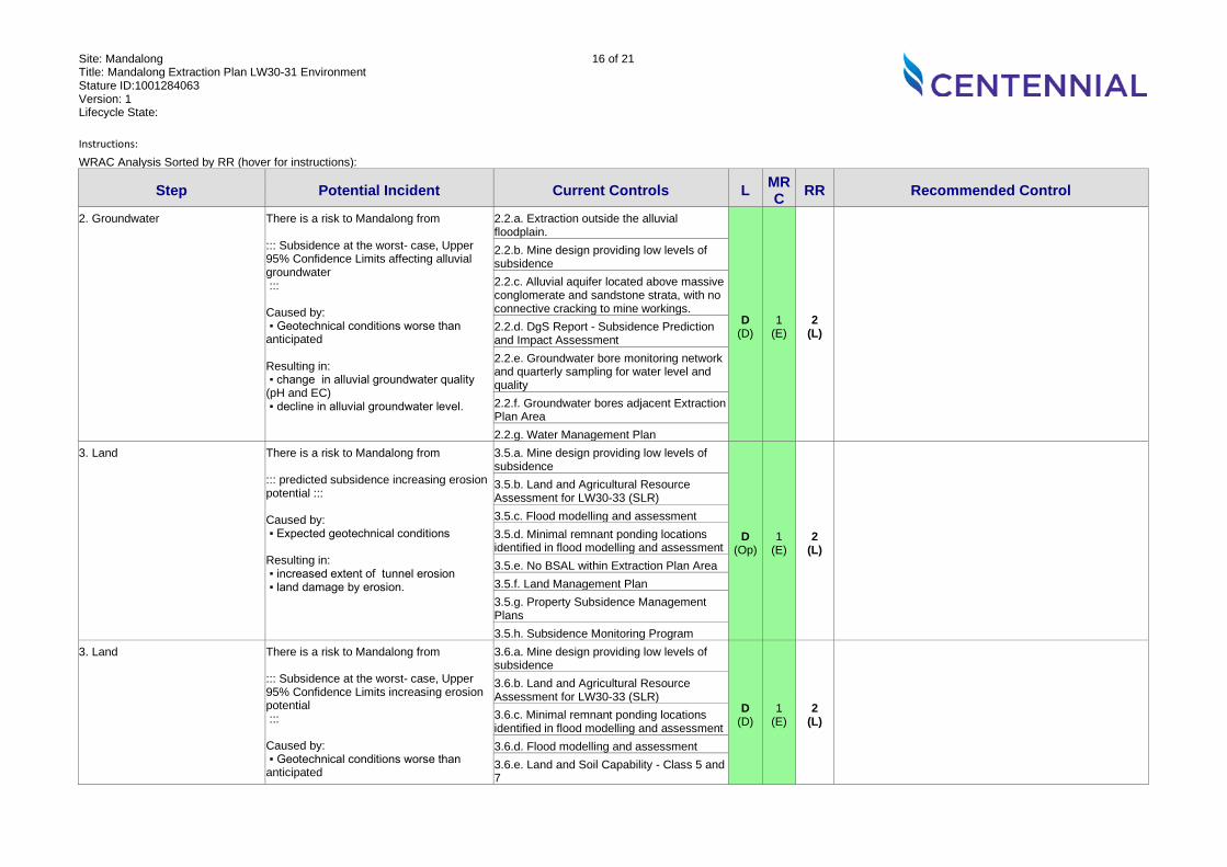
2. Groundwater There is a risk to Mandalong from ::: Subsidence at the worst- case, Upper 95% Confidence Limits affecting alluvial groundwater ::: Caused by: ▪ Geotechnical conditions worse than anticipated Resulting in: ▪ change in alluvial groundwater quality (pH and EC) ▪ decline in alluvial groundwater level.
2.2.a. Extraction outside the alluvial floodplain.
D (D)
1 (E)
2 (L)
2.2.b. Mine design providing low levels of subsidence 2.2.c. Alluvial aquifer located above massive conglomerate and sandstone strata, with no connective cracking to mine workings. 2.2.d. DgS Report - Subsidence Prediction and Impact Assessment 2.2.e. Groundwater bore monitoring network and quarterly sampling for water level and quality 2.2.f. Groundwater bores adjacent Extraction Plan Area 2.2.g. Water Management Plan
3. Land There is a risk to Mandalong from ::: predicted subsidence increasing erosion potential ::: Caused by: ▪ Expected geotechnical conditions Resulting in: ▪ increased extent of tunnel erosion ▪ land damage by erosion.
3.5.a. Mine design providing low levels of subsidence
D (Op)
1 (E)
2 (L)
3.5.b. Land and Agricultural Resource Assessment for LW30-33 (SLR) 3.5.c. Flood modelling and assessment 3.5.d. Minimal remnant ponding locations identified in flood modelling and assessment 3.5.e. No BSAL within Extraction Plan Area 3.5.f. Land Management Plan 3.5.g. Property Subsidence Management Plans 3.5.h. Subsidence Monitoring Program
3. Land There is a risk to Mandalong from ::: Subsidence at the worst- case, Upper 95% Confidence Limits increasing erosion potential ::: Caused by: ▪ Geotechnical conditions worse than anticipated
3.6.a. Mine design providing low levels of subsidence
D (D)
1 (E)
2 (L)
3.6.b. Land and Agricultural Resource Assessment for LW30-33 (SLR) 3.6.c. Minimal remnant ponding locations identified in flood modelling and assessment 3.6.d. Flood modelling and assessment 3.6.e. Land and Soil Capability - Class 5 and 7

Site: Mandalong Title: Mandalong Extraction Plan LW30-31 Environment Stature ID:1001284063 Version: 1 Lifecycle State:
17 of 21
Instructions:
WRAC Analysis Sorted by RR (hover for instructions):
Step Potential Incident Current Controls L MRC RR Recommended Control
Resulting in: ▪ increased extent of tunnel erosion ▪ land damage by erosion.
3.6.f. No BSAL within Extraction Plan Area 3.6.g. Land Management Plan 3.6.h. Property Subsidence Management Plans 3.6.i. Subsidence Monitoring Program
3. Land There is a risk to Mandalong from ::: predicted subsidence affecting agricultural land capability ::: Caused by: ▪ Expected geotechnical conditions Resulting in: ▪ impact on agricultural land use.
3.3.a. Mine design providing low levels of subsidence
E (D)
1 (E)
1 (L)
3.3.b. Land and Agricultural Resource Assessment for LW30-33 (SLR) 3.3.c. Flood modelling and assessment 3.3.d. Potential remnant ponding locations identified in flood modelling and assessment 3.3.e. Land Management Plan 3.3.f. Property Subsidence Management Plans 3.3.g. Land and Soil Capability - Class 5 and 7 3.3.h. Minimal domestic agriculture 3.3.i. No BSAL within Extraction Plan Area
3. Land There is a risk to Mandalong from ::: Subsidence at the worst- case, Upper 95% Confidence Limits affecting agricultural land capability ::: Caused by: ▪ Geotechnical conditions worse than anticipated Resulting in: ▪ impact on agricultural land use.
3.4.a. Minimal domestic agriculture
E (D)
1 (E)
1 (L)
3.4.b. Land and Soil Capability - Class 5 and 7 3.4.c. Mine design providing low levels of subsidence 3.4.d. Land and Agricultural Resource Assessment for LW30-33 (SLR) 3.4.e. Flood modelling and assessment 3.4.f. Potential remnant ponding locations identified in flood modelling and assessment 3.4.g. No BSAL within Extraction Plan Area 3.4.h. Property Subsidence Management Plans
Site: Mandalong Title: Mandalong Extraction Plan LW30-31 Environment Stature ID:1001284063 Version: 1 Lifecycle State:
18 of 21
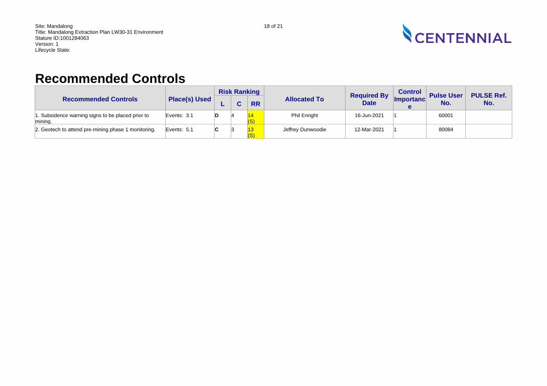
Recommended Controls Recommended Controls Place(s) Used
Risk Ranking Allocated To Required By
Date Control
Importance
Pulse User No.
PULSE Ref. No. L C RR
1. Subsidence warning signs to be placed prior to mining.
Events: 3.1 D 4 14 (S)
Phil Enright 16-Jun-2021 1 60001
2. Geotech to attend pre-mining phase 1 monitoring. Events: 5.1 C 3 13 (S)
Jeffrey Dunwoodie 12-Mar-2021 1 80084
Site: Mandalong Title: Mandalong Extraction Plan LW30-31 Environment Stature ID:1001284063 Version: 1 Lifecycle State:
19 of 21
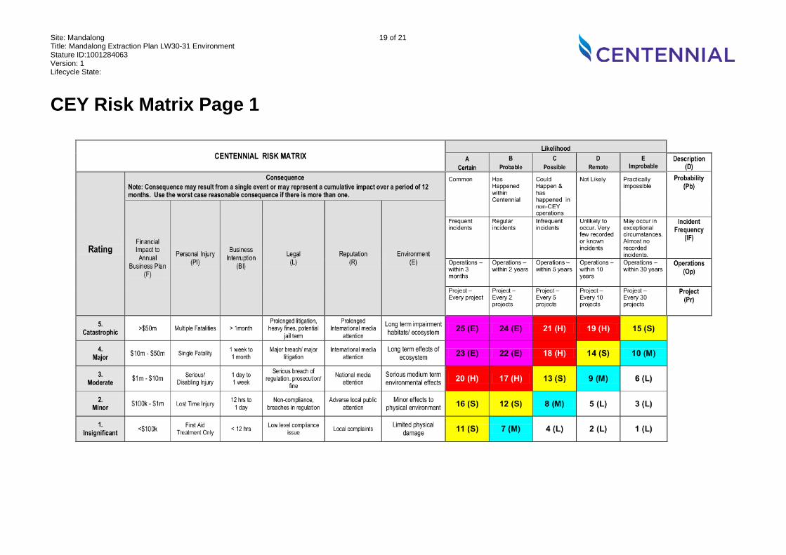
CEY Risk Matrix Page 1
Site: Mandalong Title: Mandalong Extraction Plan LW30-31 Environment Stature ID:1001284063 Version: 1 Lifecycle State:
20 of 21
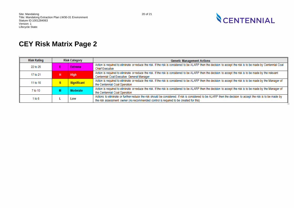
CEY Risk Matrix Page 2
Site: Mandalong Title: Mandalong Extraction Plan LW30-31 Environment Stature ID:1001284063 Version: 1 Lifecycle State:
21 of 21
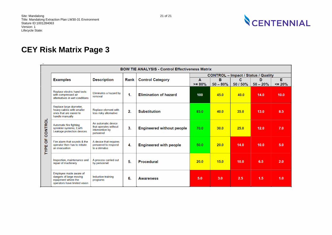
CEY Risk Matrix Page 3


![Risk Management (3C05/D22) Unit 3: Risk Management · 2004. 4. 29. · Risk-management planning Risk resolution [Boehm 1991] Risk monitoring Software risk management steps & techniques](https://img.pdfslide.net/doc/110x75/6122993708b35f7a264d6759/risk-management-3c05d22-unit-3-risk-2004-4-29-risk-management-planning.jpg)