Embed Size (px)
Citation preview
STATUS, PRIORITIES AND NEEDS FOR SUSTAINABLE
SOIL MANAGEMENT IN SUDANSOIL MANAGEMENT IN SUDAN
AbdelMagidAbdelMagid Ali Ali ElMobarakElMobarakLand and Water Research Centre,Land and Water Research Centre,
ARC, Wad ARC, Wad MedaniMedani,,SudanSudan
Workshop on Global Soil Partnership in East and Southern AfricaWorkshop on Global Soil Partnership in East and Southern Africa2525--27 March 201327 March 2013
NairobiNairobi--KenyaKenya
The Soils of The Sudan• 1‐ Introduction
– Sudan is one of the largest African countries.
– It covers about 13 degrees latitudes crossing a range of climatic zones from dry monsoon to bare desert.
– The soils reflect the climatic diversity and the local conditionsconditions.
– The soils are very fine to course and shallow to very deep.
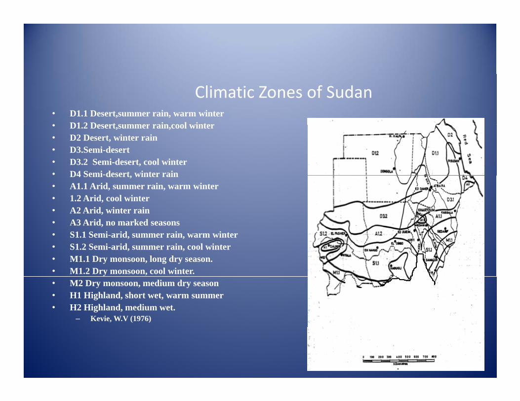
Climatic Zones of Sudan• D1.1 Desert,summer rain, warm winter• D1 2 Desert summer rain cool winter• D1.2 Desert,summer rain,cool winter• D2 Desert, winter rain• D3.Semi-desert• D3.2 Semi-desert, cool winter• D4 Semi-desert winter rainD4 Semi-desert, winter rain• A1.1 Arid, summer rain, warm winter• 1.2 Arid, cool winter• A2 Arid, winter rain• A3 Arid, no marked seasons,• S1.1 Semi-arid, summer rain, warm winter• S1.2 Semi-arid, summer rain, cool winter• M1.1 Dry monsoon, long dry season.• M1.2 Dry monsoon, cool winter.• M2 Dry monsoon, medium dry season• H1 Highland, short wet, warm summer• H2 Highland, medium wet.
– Kevie, W.V (1976)
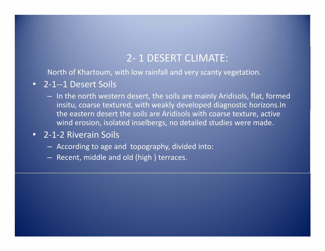
2‐ 1 DESERT CLIMATE:North of Khartoum, with low rainfall and very scanty vegetation.
• 2‐1‐‐1 Desert Soils– In the north western desert, the soils are mainly Aridisols, flat, formed
insitu, coarse textured, with weakly developed diagnostic horizons.In the eastern desert the soils are Aridisols with coarse texture, active wind erosion, isolated inselbergs, no detailed studies were made.
• 2‐1‐2 Riverain Soils– According to age and topography, divided into:– Recent, middle and old (high ) terraces.
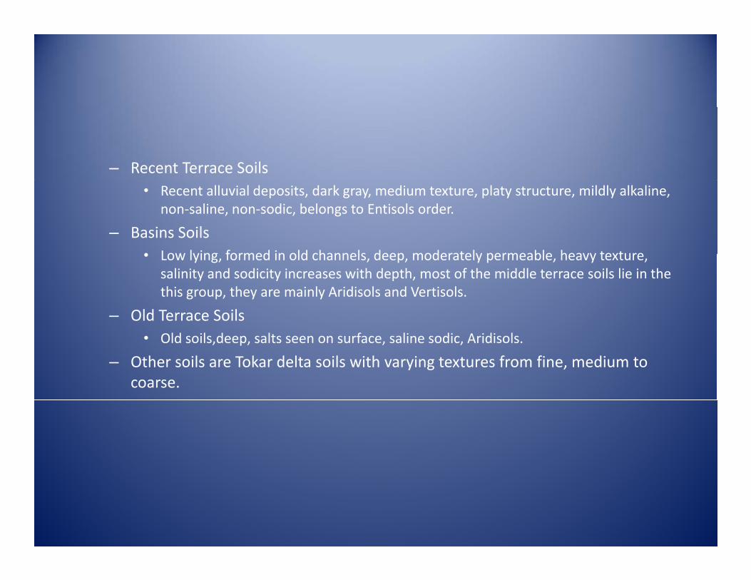
– Recent Terrace Soils• Recent alluvial deposits, dark gray, medium texture, platy structure, mildly alkaline,
non‐saline, non‐sodic, belongs to Entisols order.
– Basins Soils• Low lying formed in old channels deep moderately permeable heavy texture• Low lying, formed in old channels, deep, moderately permeable, heavy texture,
salinity and sodicity increases with depth, most of the middle terrace soils lie in the this group, they are mainly Aridisols and Vertisols.
– Old Terrace Soils• Old soils,deep, salts seen on surface, saline sodic, Aridisols.
– Other soils are Tokar delta soils with varying textures from fine, medium to coarse.
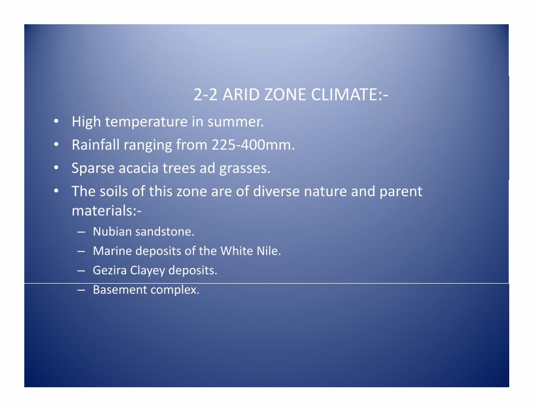
2‐2 ARID ZONE CLIMATE:‐• High temperature in summer.g p
• Rainfall ranging from 225‐400mm.
• Sparse acacia trees ad grasses.
• The soils of this zone are of diverse nature and parent materials:‐
Nubian sandstone– Nubian sandstone.
– Marine deposits of the White Nile.
– Gezira Clayey deposits.
– Basement complex.
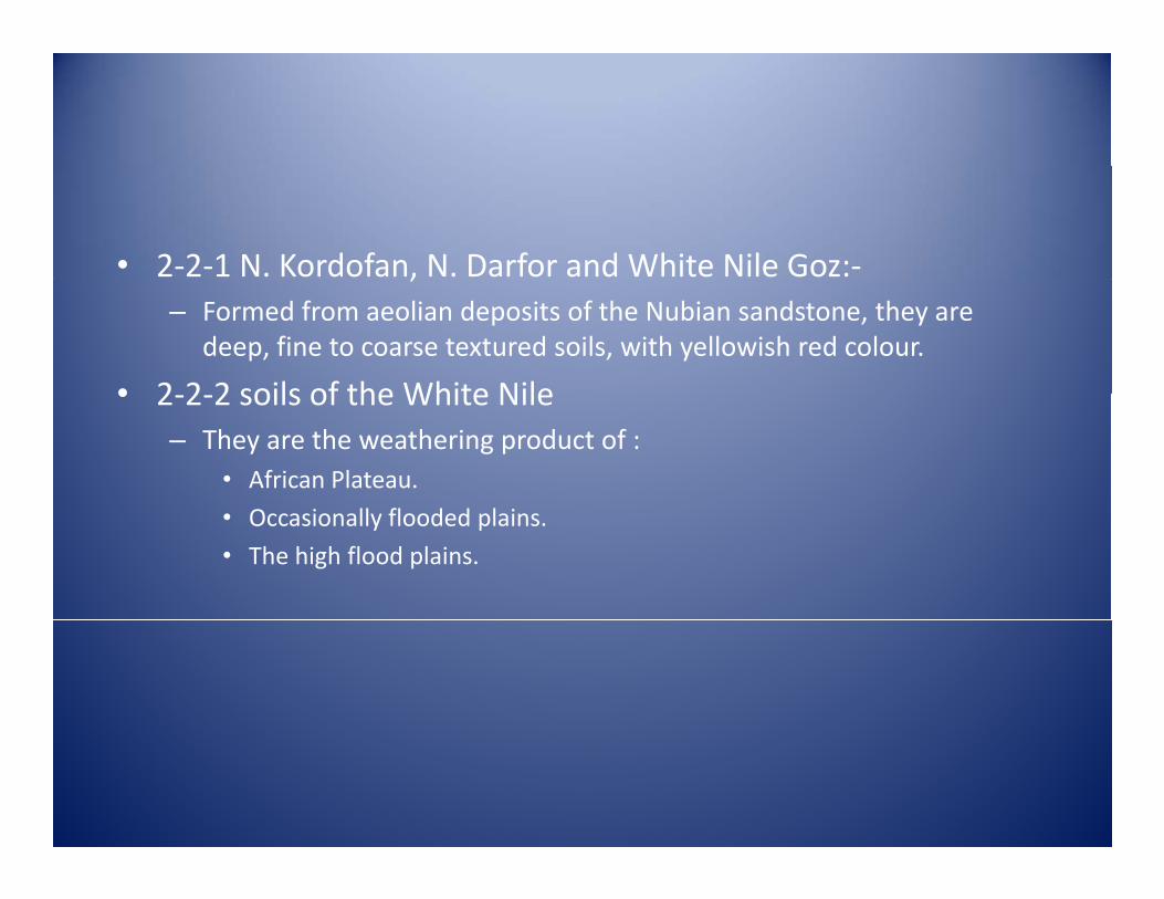
• 2‐2‐1 N. Kordofan, N. Darfor and White Nile Goz:‐,– Formed from aeolian deposits of the Nubian sandstone, they are
deep, fine to coarse textured soils, with yellowish red colour.
• 2 2 2 soils of the White Nile• 2‐2‐2 soils of the White Nile– They are the weathering product of :
• African Plateau.
• Occasionally flooded plains.
• The high flood plains.
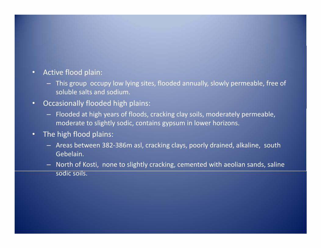
• Active flood plain:– This group occupy low lying sites, flooded annually, slowly permeable, free of
soluble salts and sodium.
• Occasionally flooded high plains:– Flooded at high years of floods, cracking clay soils, moderately permeable,
moderate to slightly sodic, contains gypsum in lower horizons.
• The high flood plains:– Areas between 382‐386m asl, cracking clays, poorly drained, alkaline, south
Gebelain.
– North of Kosti, none to slightly cracking, cemented with aeolian sands, saline di ilsodic soils.
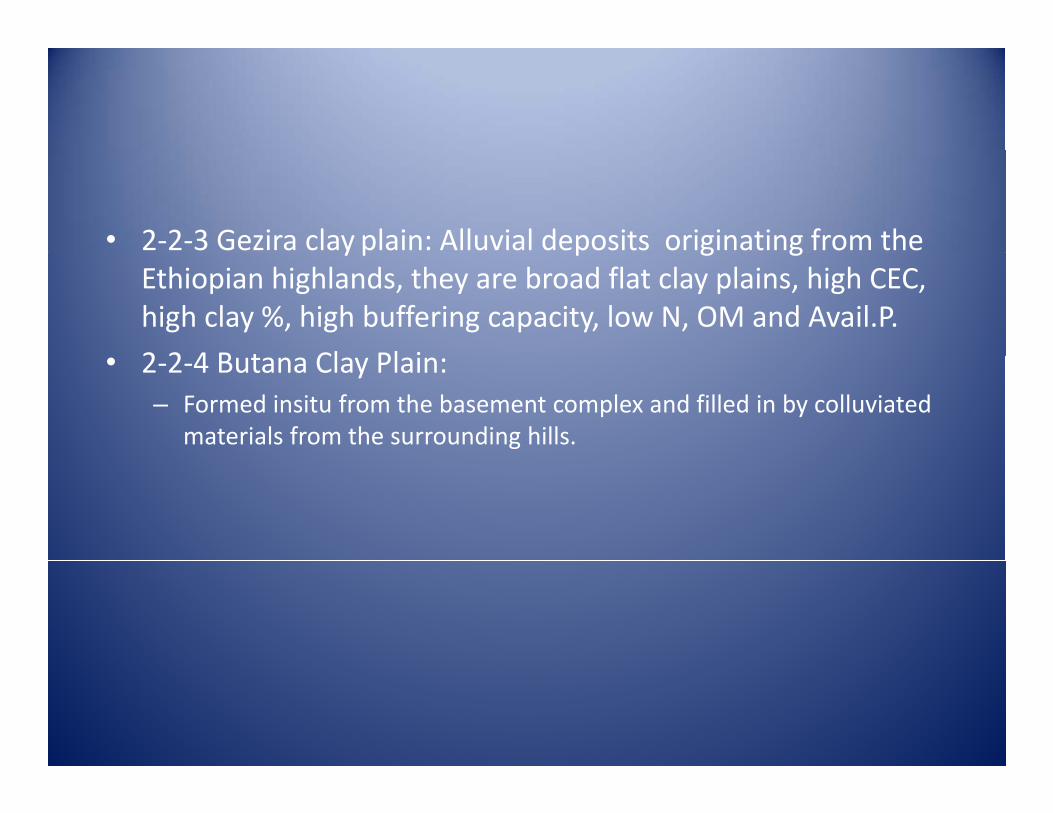
• 2‐2‐3 Gezira clay plain: Alluvial deposits originating from the y p p g gEthiopian highlands, they are broad flat clay plains, high CEC, high clay %, high buffering capacity, low N, OM and Avail.P.
2 2 4 B t Cl Pl i• 2‐2‐4 Butana Clay Plain:– Formed insitu from the basement complex and filled in by colluviated
materials from the surrounding hills.
• 2‐2‐5 Gash Delta– Recent alluvial deposits from the igneous rocks of the basement
complex, divided physiographicaly and texture wise to:• Medium textured soils, permeable, free of soluble salts, belongs toMedium textured soils, permeable, free of soluble salts, belongs to Entisols.
• Fine textured soils, wide cracks, similar to the clays of the central clay plain, but less saline and contains less gypsum and CaCO3 , falling into the Vertisols order.
2‐3 SEMI‐ARID CLIMATE• Hot summer and warm winter
• Rainfall 400‐ 750 mm.
• Savannah trees and long grasses.
• 2‐3‐1 Dinder‐Kenana Plains:All i l d i f h Bl Nil f d f h h i f h– Alluvial deposits of the Blue Nile, formed from the weathering of the basement complex.
– Heavy texture soils, with very high clay content, deep, widely cracking, l li d dicalcareous, non‐saline and non‐sodic.
• 2‐3‐2 Gedarif‐Gallabat:– Formed insitu, deep, cracking clays, with inclusions of Azaza( red
sealed surface soils) Alfisols.
• 2‐3‐3 Nuba Mountains:– Large granitic hills intersected by wide clay plains formed either insitu,
by water or colluviated materials from the surrounding hills. The soils are deep cracking clays, free of salts, neutral to acidic.
– Gardud soils( Alfisols) are found in this region, they are red colour soils and free of slats.
• 2‐3‐4 The Soils of South Darfor– Ragaba soils formed by meandering channelsmixture of clays and
non‐cracking light texture soils.
– Naqa’a heavy or medium texture soils( physiography) sealedNaqa a heavy or medium texture soils( physiography) sealed surface, salt free.
– Baggara Repeating PatternTwo or more soil types(clays and naqa’a) in a continuous repeated pattern They are affected by water and windin a continuous repeated pattern. They are affected by water and wind erosion.
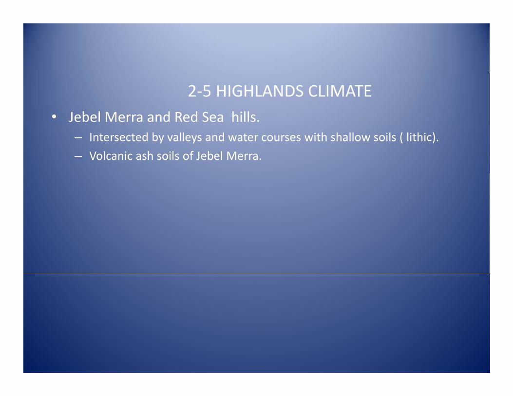
2‐5 HIGHLANDS CLIMATE• Jebel Merra and Red Sea hills.
– Intersected by valleys and water courses with shallow soils ( lithic).
– Volcanic ash soils of Jebel Merra.
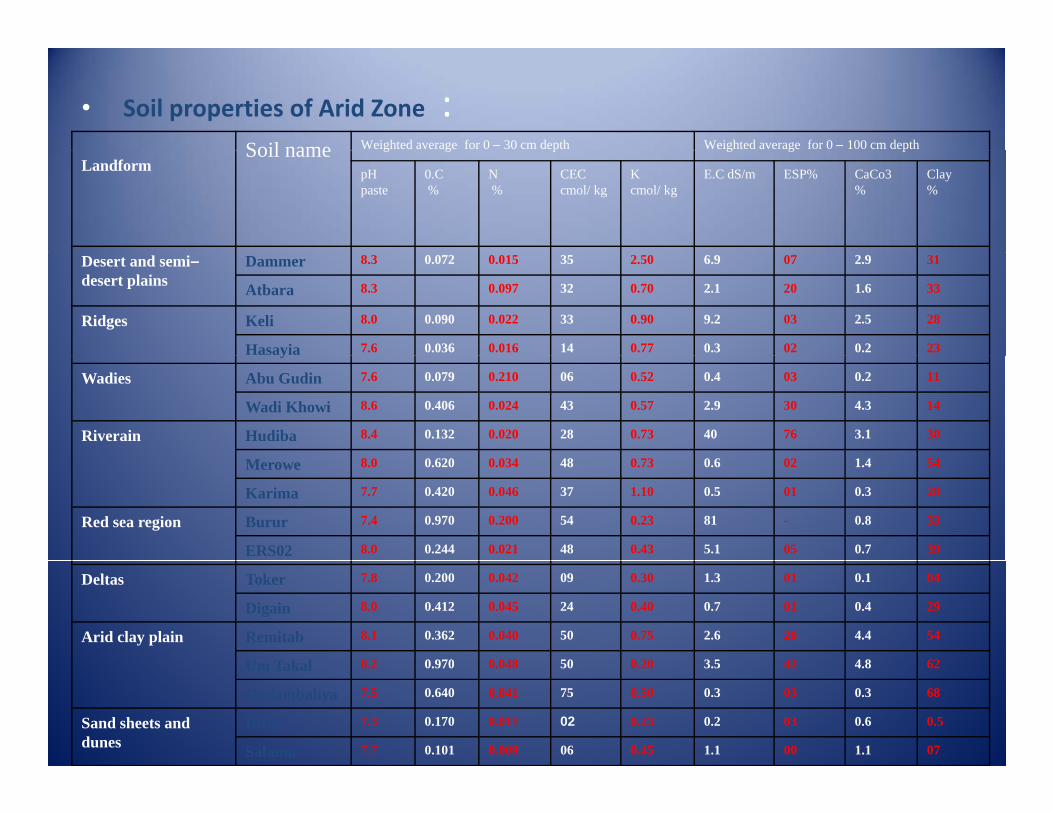
• Soil properties of Arid Zone :Weighted average for 0 – 100 cm depthWeighted average for 0 – 30 cm depthSoil name g g pg g pSoil name
Landform Clay%
CaCo3%
ESP%E.C dS/m K cmol/ kg
CEC cmol/ kg
N %
0.C%
pH paste
312.9076.92.50350.0150.0728.3DammerDesert and semi–desert plains 331.6202.10.70320.0978.3Atbara
282.5039.20.90330.0220.0908.0KeliRidges230.2020.30.77140.0160.0367.6Hasayiay110.2030.40.52060.2100.0797.6Abu GudinWadies
144.3302.90.57430.0240.4068.6Wadi Khowi
303.176400.73280.0200.1328.4HudibaRiverain541.4020.60.73480.0340.6208.0Merowe280.3010.51.10370.0460.4207.7Karima330.8-810.23540.2000.9707.4BururRed sea region
390.7055.10.43480.0210.2448.0ERS02
040.1011.30.30090.0420.2007.8TokerDeltas290.4010.70.40240.0450.4128.0Digain544.4202.60.75500.0400.3628.1RemitabArid clay plain624 8423 50 20500 0480 9708 2U T k l 624.8423.50.20500.0480.9708.2Um Takal680.3030.30.50750.0410.6407.5Gadambaliya0.50.6030.20.23020.0110.1707.3DittoSand sheets and
dunes 071.1001.10.45060.0090.1017.7Salama
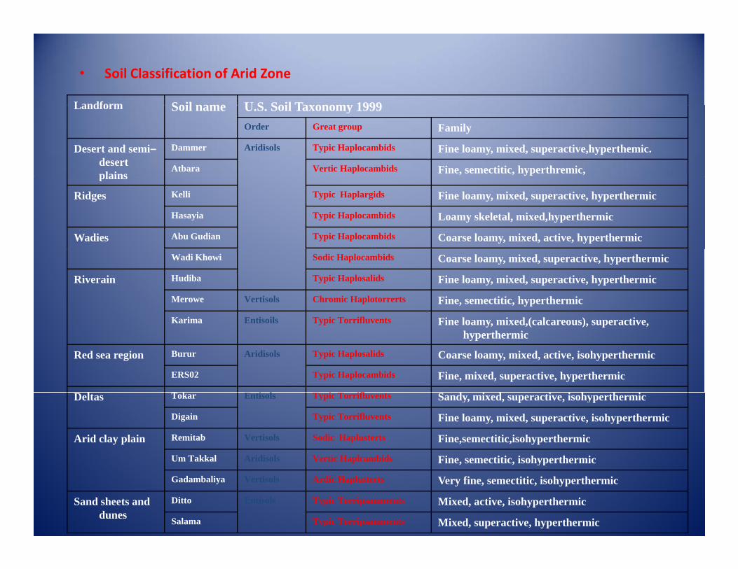
• Soil Classification of Arid Zone
U S Soil Taxonomy 1999Soil nameLandform U.S. Soil Taxonomy 1999Soil nameLandform
FamilyGreat groupOrder
Fine loamy, mixed, superactive,hyperthemic.Typic HaplocambidsAridisolsDammerDesert and semi–desert plains Fine, semectitic, hyperthremic,Vertic HaplocambidsAtbaraplains
Fine loamy, mixed, superactive, hyperthermicTypic HaplargidsKelliRidges
Loamy skeletal, mixed,hyperthermicTypic HaplocambidsHasayia
Coarse loamy, mixed, active, hyperthermicTypic HaplocambidsAbu GudianWadies
Coarse loamy, mixed, superactive, hyperthermicSodic HaplocambidsWadi Khowi
Fine loamy, mixed, superactive, hyperthermicTypic HaplosalidsHudibaRiverain
Fine, semectitic, hyperthermicChromic HaplotorrertsVertisolsMerowe
Fine loamy mixed (calcareous) superactiveTypic TorrifluventsEntisoilsKarima Fine loamy, mixed,(calcareous), superactive, hyperthermic
Typic TorrifluventsEntisoilsKarima
Coarse loamy, mixed, active, isohyperthermicTypic HaplosalidsAridisolsBururRed sea region
Fine, mixed, superactive, hyperthermicTypic HaplocambidsERS02
i ifi Sandy, mixed, superactive, isohyperthermicTypic TorrifluventsEntisolsTokarDeltas
Fine loamy, mixed, superactive, isohyperthermicTypic TorrifluventsDigain
Fine,semectitic,isohyperthermicSodic Haplusterts VertisolsRemitabArid clay plain
Fine, semectitic, isohyperthermicVertic HaplcambidsAridisolsUm Takkal , , yp
Very fine, semectitic, isohyperthermicArdic Haplusterts VertisolsGadambaliya
Mixed, active, isohyperthermicTypic TorripsammentsEntisolsDittoSand sheets and dunes
Mixed, superactive, hyperthermic Typic TorripsammentsSalama
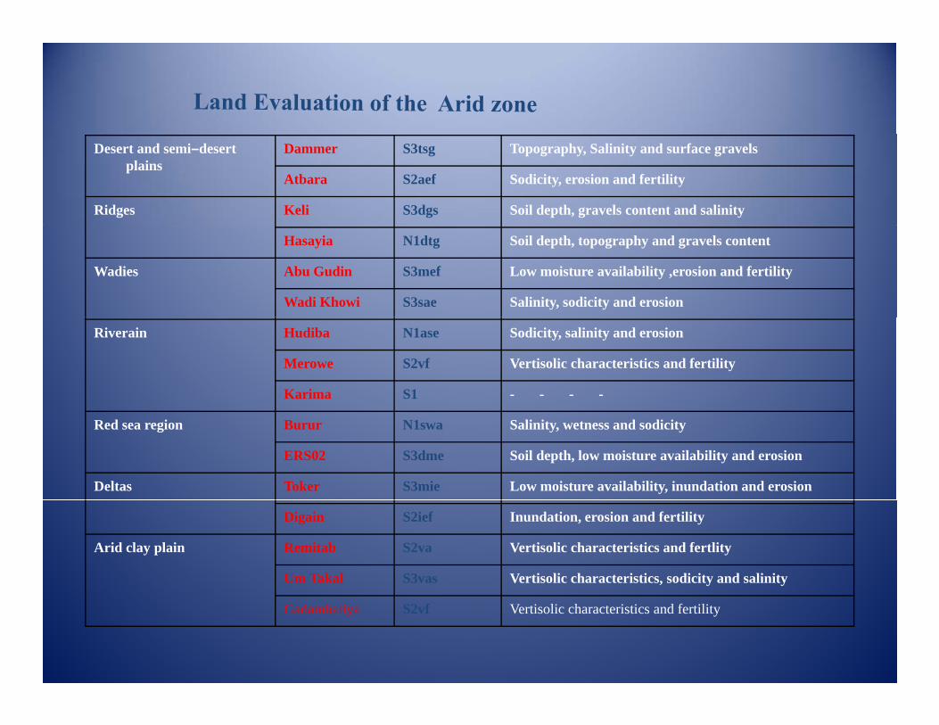
Topography, Salinity and surface gravelsS3tsgDammerDesert and semi–desert plains
Sodicity, erosion and fertilityS2aefAtbara
Soil depth, gravels content and salinityS3dgsKeliRidges
Soil depth, topography and gravels contentN1dtgHasayia
Low moisture availability ,erosion and fertilityS3mefAbu GudinWadies
Salinity, sodicity and erosionS3saeWadi Khowi
Sodicity, salinity and erosionN1aseHudibaRiverain
Vertisolic characteristics and fertilityS2vfMerowe
- - - -S1Karima
Salinity, wetness and sodicityN1swaBururRed sea region
Soil depth, low moisture availability and erosionS3dmeERS02
Low moisture availability, inundation and erosionS3mieTokerDeltas
Inundation, erosion and fertilityS2iefDigain
Vertisolic characteristics and fertlityS2vaRemitabArid clay plain
Vertisolic characteristics, sodicity and salinityS3vasUm Takal
Vertisolic characteristics and fertilityS2vfGadambaliya
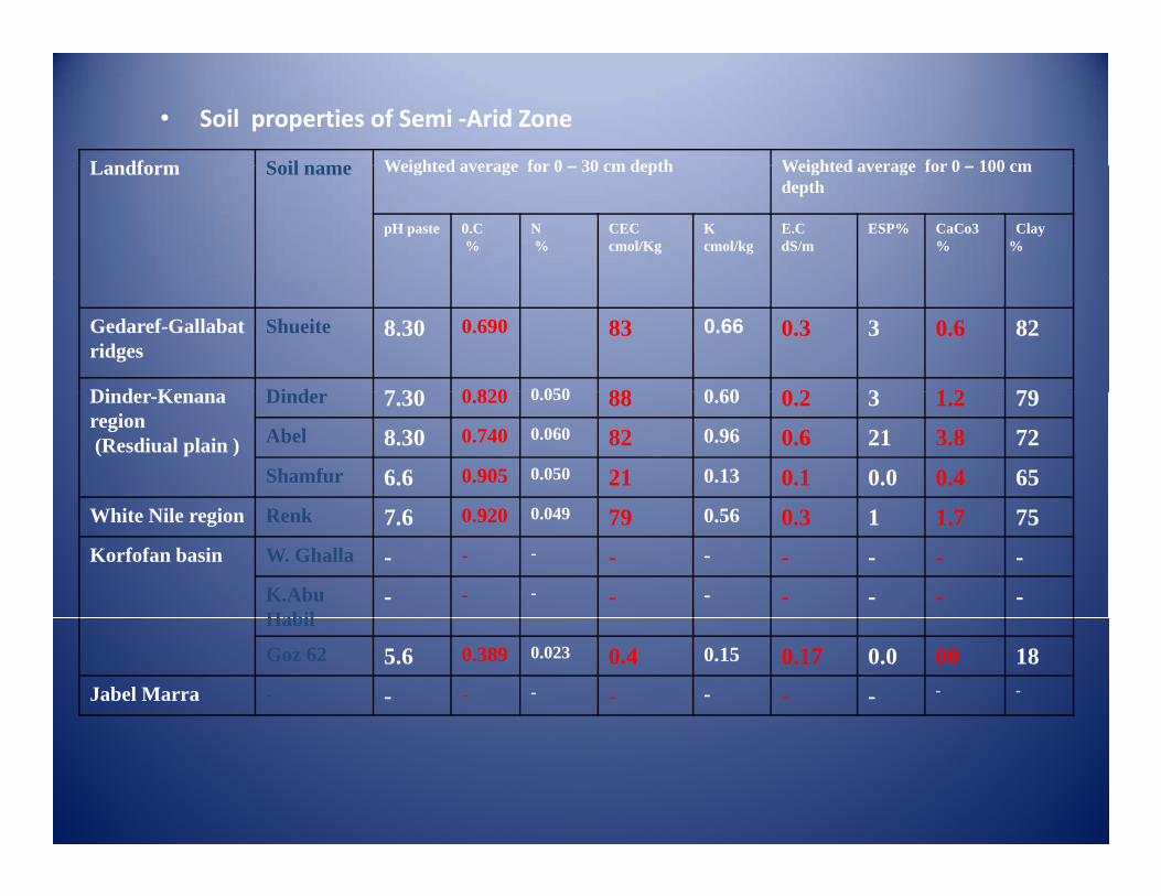
• Soil properties of Semi ‐Arid Zone
Weighted average for 0 100 cmWeighted average for 0 30 cm depthSoil nameLandform Weighted average for 0 – 100 cm depth
Weighted average for 0 – 30 cm depthSoil nameLandform
Clay %
CaCo3%
ESP%E.CdS/m
K cmol/kg
CEC cmol/Kg
N %
0.C%
pH paste
820.630.30.66830.6908.30ShueiteGedaref-Gallabat ridges
791 230 20 60880 05008207 30Di dDi d K 791.230.20.60880.0500.8207.30DinderDinder-Kenana region(Resdiual plain ) 723.8210.60.96820.0600.7408.30Abel
650.40.00.10.13210.0500.9056.6Shamfur
751.710.30.56790.0490.9207.6RenkWhite Nile region
---------W. GhallaKorfofan basin
---------K.Abu HabilHabil
18000.00.170.150.40.0230.3895.6Goz 62
----------Jabel Marra
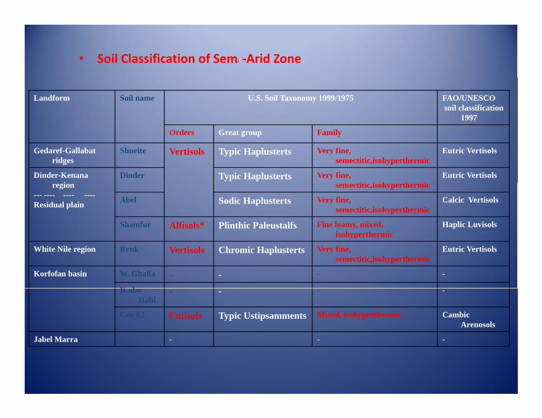
• Soil Classification of Semi ‐Arid Zone
FAO/UNESCOsoil classification
1997
U.S. Soil Taxonomy 1999/1975Soil nameLandform
F ilG tO d FamilyGreat groupOrders
Eutric VertisolsVery fine, semectitic,isohyperthermic
Typic HaplustertsVertisolsShueiteGedaref-Gallabat ridges
Eutric VertisolsVery fine, titi i h th i
Typic HaplustertsDinderDinder-Kenana i semectitic,isohyperthermicregion
--- ---- ---- ----Residual plain Calcic VertisolsVery fine,
semectitic,isohyperthermicSodic HaplustertsAbel
Haplic LuvisolsFine loamy, mixed, isohyperthermic
Plinthic PaleustalfsAlfisols*Shamfurisohyperthermic
Eutric VertisolsVery fine, semectitic,isohyperthermic
Chromic HaplustertsVertisolsRenkWhite Nile region
----W. GhallaKorfofan basin
K b ----K.abu Habl
Cambic Arenosols
Mixed, isohyperthermicTypic UstipsammentsEntisolsGoz 62
----Jabel MarraJabel Marra
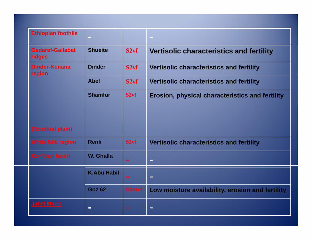
--Ethiopian foothils
Vertisolic characteristics and fertilityS2vfShueiteGedaref-Gallabat ridges
Vertisolic characteristics and fertilityS2vfDinderDinder-Kenana regionregion
Vertisolic characteristics and fertilityS2vfAbel
Erosion, physical characteristics and fertilityS2vfShamfur
(Resdiual plain)
Vertisolic characteristics and fertilityS2vfRenkWhite Nile region
--W. GhallaKorfofan basin
--K.Abu Habil
Low moisture availability, erosion and fertilityS3mefGoz 62
---Jabel Marra
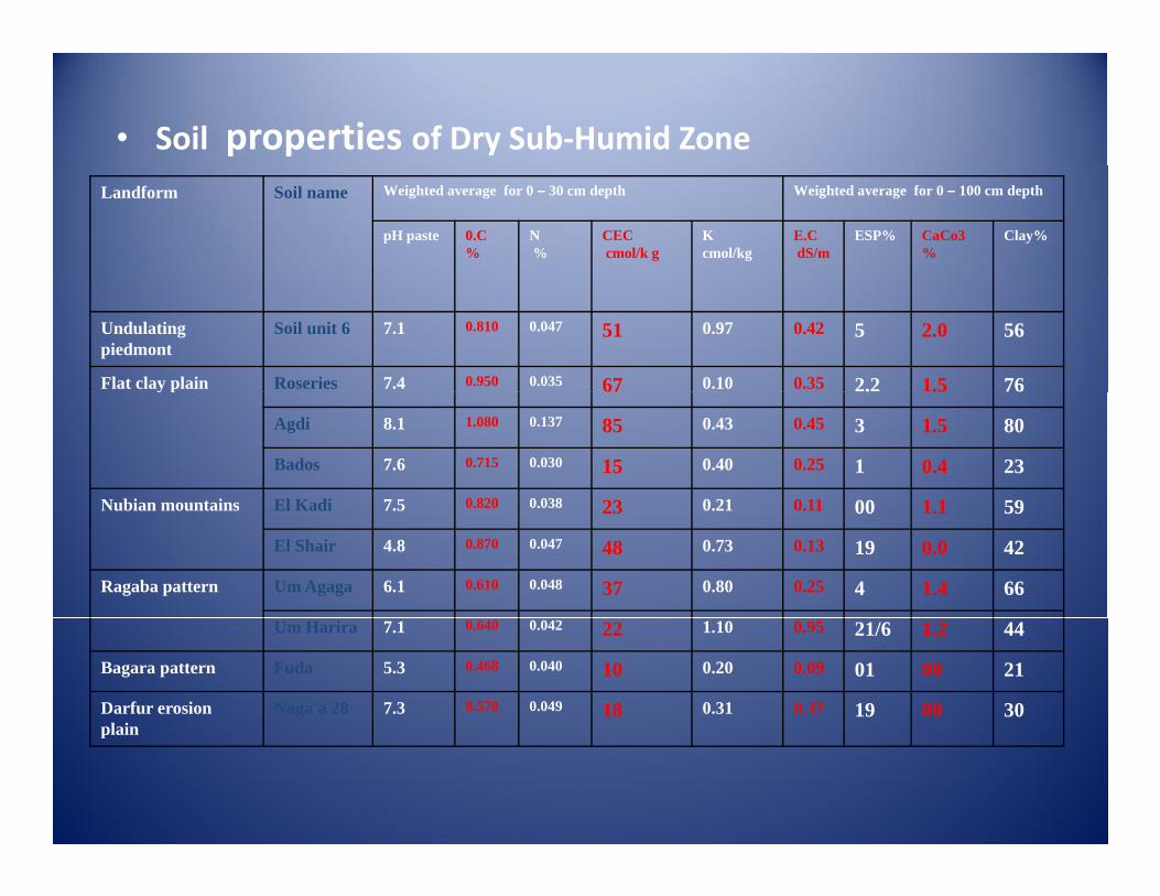
• Soil properties of Dry Sub‐Humid ZoneWeighted average for 0 – 100 cm depthWeighted average for 0 – 30 cm depthSoil nameLandform
Clay%CaCo3%
ESP%E.CdS/m
K cmol/kg
CECcmol/k g
N %
0.C%
pH paste
562.050.420.97510.0470.8107.1Soil unit 6Undulating piedmont
761.52.20.350.10670.0350.9507.4RoseriesFlat clay plain 76.5.67y p
801.530.450.43850.1371.0808.1Agdi
230.410.250.40150.0300.7157.6Bados
591 1000 110 21230 0380 8207 5El KadiNubian mountains 591.1000.110.21230.0380.8207.5El KadiNubian mountains
420.0190.130.73480.0470.8704.8El Shair
661.440.250.80370.0480.6106.1Um AgagaRagaba pattern
441.221/60.951.10220.0420.6407.1Um Harira
2100010.090.20100.0400.4685.3FudaBagara pattern
3000190.370.31180.0490.5707.3Naga'a 28Darfur erosion plainplain
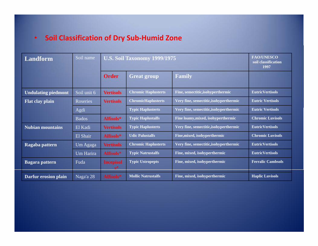
• Soil Classification of Dry Sub‐Humid Zone
FAO/UNESCOsoil classification
1997
U.S. Soil Taxonomy 1999/1975Soil nameLandform
FamilyGreat groupOrder FamilyGreat groupOrder
EutricVertisolsFine, semectitic,isohyperthermicChromic HaplustertsVertisolsSoil unit 6Undulating piedmontEutric VertisolsVery fine, semectitic,isohyperthermicChromicHaplustertsVertisolsRoseriesFlat clay plain
Eutric VertisolsVery fine, semectitic,isohyperthermicTypic HaplustertsAgdi
Chromic LuvisolsFine loamy,mixed, isohyperthermicTypic Haplustalfs Alfisols*BadosEutricVertisolsVery fine, semectitic,isohyperthermicTypic HaplustertsVertisolsEl KadiNubian mountainsChromic LuvisolsFine,mixed, isohyperthermicUdic PalustalfsAlfisols*El ShairEutricVertisolsVery fine, semectitic,isohyperthermicChromic HaplustertsVertisolsUm AgagaRagaba patternEutricVertisolsFine, mixed, isohyperthermicTypic NatrustalfsAlfisols*Um Harira
Ferralic CambsolsFine, mixed, isohyperthermicTypic UstropeptsIncepisols*
FudaBagara pattern
Haplic LuvisolsFine, mixed, isohyperthermicMollic NatrustalfsAlfisols*Naga'a 28Darfur erosion plain
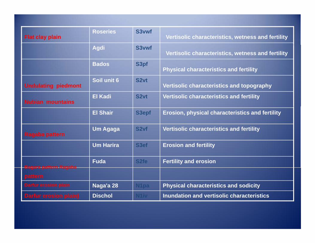
Vertisolic characteristics, wetness and fertilityS3vwf Roseries
Flat clay plain
Vertisolic characteristics, wetness and fertilityS3vwf Agdi
Physical characteristics and fertilityS3pf Bados
Vertisolic characteristics and topographyS2vt Soil unit 6
Undulating piedmont
Vertisolic characteristics and fertilityS2vt El Kadi Nubian mountains
Erosion, physical characteristics and fertilityS3epf El Shair
Vertisolic characteristics and fertilityS2vf Um Agaga Ragaba patterng p
Erosion and fertilityS3ef Um Harira
Fertility and erosionS2fe Fuda Bagara pattern RagabaBagara pattern Ragaba
pattern Physical characteristics and sodicityN1pa Naga'a 28 Darfur erosion plain
Inundation and vertisolic characteristicsN1iv Dischol Darfur erosion plain) p )
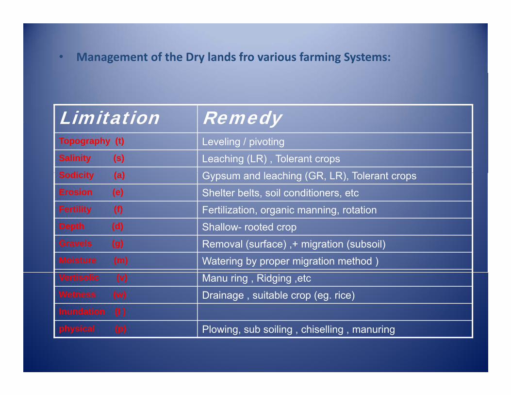
• Management of the Dry lands fro various farming Systems:
RemedyLimitation RemedyLimitationLeveling / pivotingTopography (t)
Leaching (LR) , Tolerant cropsSalinity (s)
G d l hi (GR LR) T l tS di it ( ) Gypsum and leaching (GR, LR), Tolerant cropsSodicity (a)
Shelter belts, soil conditioners, etc Erosion (e)
Fertilization, organic manning, rotation Fertility (f)
Shallow- rooted cropDepth (d)
Removal (surface) ,+ migration (subsoil)Gravels (g)
Watering by proper migration method )Moisture (m)
Manu ring , Ridging ,etcVertisolic (v)
Drainage , suitable crop (eg. rice)Wetness (w)
Inundation (I )
Plowing, sub soiling , chiselling , manuringphysical (p)
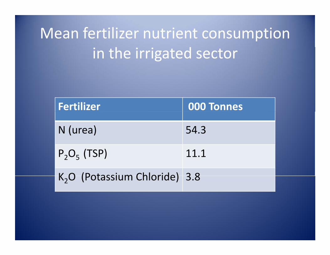
Mean fertilizer nutrient consumption h din the irrigated sector
Fertilizer 000 Tonnes
N (urea) 54.3
P2O5 (TSP) 11.1
K O (Potassium Chloride) 3 8K2O (Potassium Chloride) 3.8
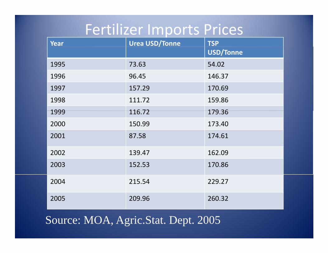
Year Urea USD/Tonne TSP
Fertilizer Imports Prices/
USD/Tonne
1995 73.63 54.02
1996 96.45 146.37
1997 157.29 170.69
1998 111.72 159.86
1999 116 72 179 361999 116.72 179.36
2000 150.99 173.40
2001 87.58 174.61
2002 139.47 162.09
2003 152.53 170.86
2004 215.54 229.27
2005 209.96 260.32
Source: MOA, Agric.Stat. Dept. 2005
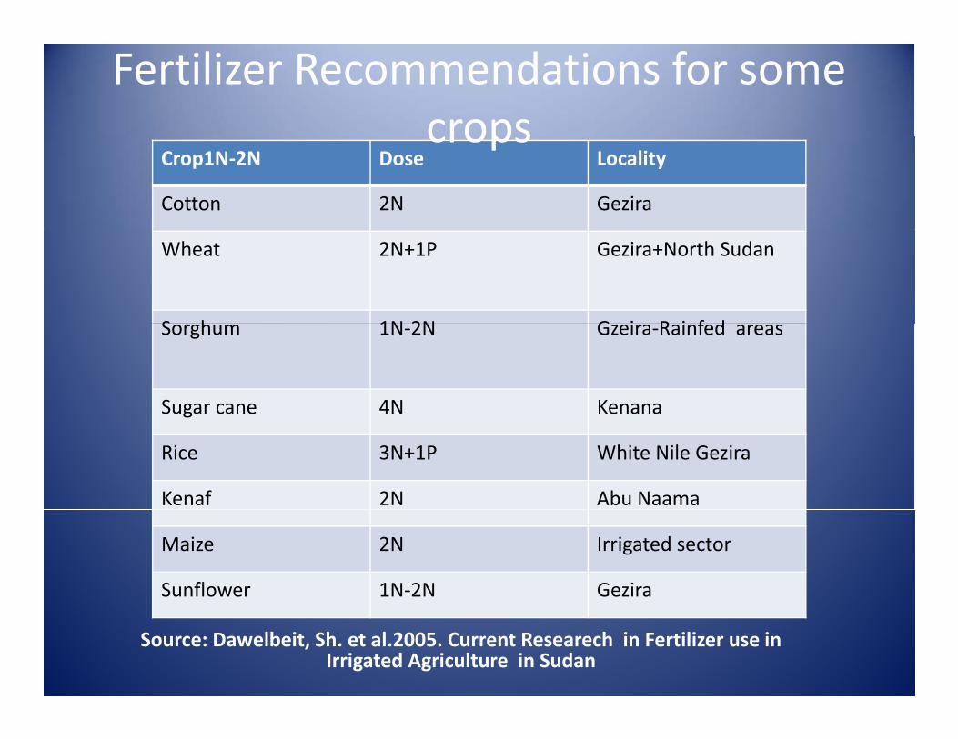
Fertilizer Recommendations for some crops
Crop1N‐2N Dose Locality
Cotton 2N Gezira
crops
Wheat 2N+1P Gezira+North Sudan
S h 1N 2N G i R i f dSorghum 1N‐2N Gzeira‐Rainfed areas
Sugar cane 4N Kenanag
Rice 3N+1P White Nile Gezira
Kenaf 2N Abu Naama
Maize 2N Irrigated sector
Sunflower 1N‐2N Gezira
Source: Dawelbeit, Sh. et al.2005. Current Researech in Fertilizer use in Irrigated Agriculture in Sudan
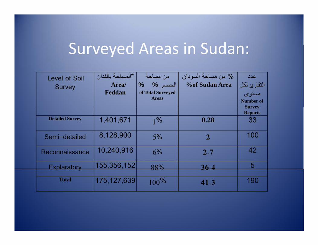
S d A i S d
L l f S il بالفدان* المساحة مساحة من السودان% مساحة من عدد
Surveyed Areas in Sudan:
Level of Soil Survey
المساحة بالفدان
Area/ Feddan
من مساحة% %الحصر
of Total Surveyed Areas
من مساحة السودان% %of Sudan Area
عددالتقاريرلكل
مستوى Number of
SurveySurvey Reports
Detailed Survey 1,401,671 1% 0.28 33
Semi-detailed 8,128,900 5% 2 100Semi detailed , , 5% 2
Reconnaissance 10,240,916 6% 2.7 42
Explaratory 155,356,152 88% 36.4 5Explaratory 88% 36.4
Total 175,127,639 100% 41.3 190
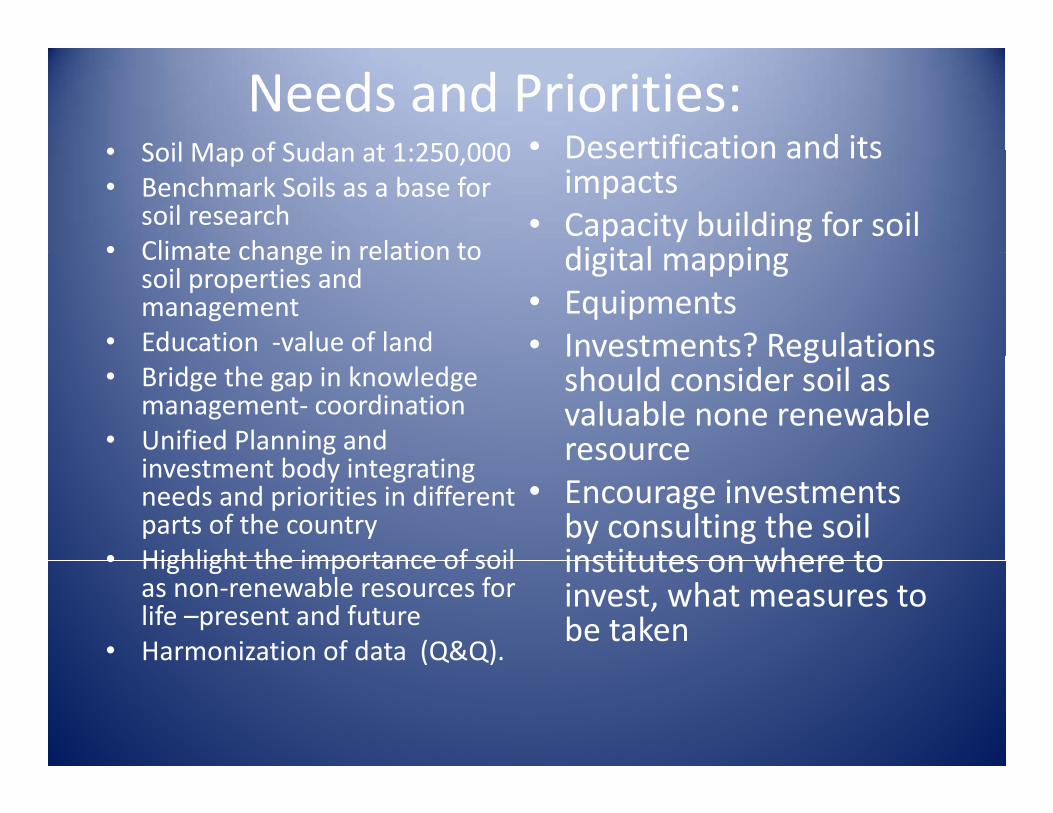
Needs and Priorities:• Soil Map of Sudan at 1:250 000 • Desertification and its• Soil Map of Sudan at 1:250,000• Benchmark Soils as a base for
soil research• Climate change in relation to
Desertification and its impacts
• Capacity building for soil di it l i• Climate change in relation to
soil properties and management
• Education ‐value of land
digital mapping• Equipments • Investments? Regulations
• Bridge the gap in knowledge management‐ coordination
• Unified Planning and b d
Investments? Regulations should consider soil as valuable none renewable resource
investment body integrating needs and priorities in different parts of the country
• Highlight the importance of soil
resource• Encourage investments by consulting the soil institutes on where to• Highlight the importance of soil
as non‐renewable resources for life –present and future
• Harmonization of data (Q&Q).
institutes on where to invest, what measures to be taken
( )
P i i iPriorities:
• Capacity building‐training‐provision of equipments
• Soil map of 1:250,000 at least
• Encourage—investment‐ set rules
• Education –endorse on soil• Awareness on the importance
of regulating the use of soil and water resources and the
• Consult the specialist on where to‐howand water resources and the
critical role they played in human life
on where to how
Thank You