Embed Size (px)
Citation preview
U.S. Department of the InteriorU.S. Geological Survey
Stratigraphy and Depositional Environments ofSediments from Five Cores fromScreven and Burke Counties, GeorgiaBy W. Fred Falls and David C. Prowell
U.S. GEOLOGICAL SURVEY PROFESSIONAL PAPER 1603-A
Prepared in cooperation with theU.S. Department of Energy and theGeorgia Geologic Survey
GEOLOGY AND PALEONTOLOGY OF FIVE CORES FROMSCREVEN AND BURKE COUNTIES, EASTERN GEORGIA
Edited by Lucy E. Edwards
CONTENTS
Abstract AlIntroduction . 1
Test Hole and Core Information 2Previous Work 4Acknowledgments 4
Stratigraphic Framework................................................................................................. 4Cretaceous Stratigraphy 7
Cape Fear Formation 9Middendorf Formation 10Black Creek Group 10Steel Creek Formation 11
Tertiary Stratigraphy 12Ellenton Formation 12Snapp Formation 13Fourmile Branch/CongareelWarley Hill Unit 13Santee Limestone 14Barnwell Unit -............................................................................................. 16
Summary 17References Cited 17
FIGURES1. Index map showing the Savannah River Site and the location of stratigraphic test holes in the study area A22. Correlation diagram showing a generalized comparison of Cretaceous and Tertiary geologic units in the
Southeastern United States 33-5. Gamma-ray, single-point resistance, and lithologic logs and geologic units of the-
3. Millhaven test hole in Screven County, Ga............................................................................................................. 54. Girard test hole in Burke County, Ga...................................................................................................................... 65. Millers Pond test well 1 and test hole in Burke County, Ga ."................................................................................ 7
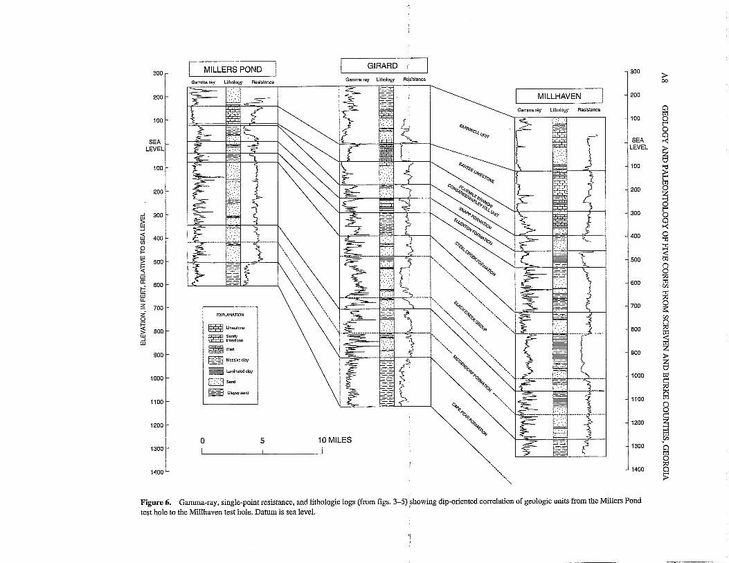
6. Gamma-ray, single-point resistance, and lithologic logs (from figs. 3-5) showing dip-oriented correlationof geologic units from the Millers Pond test hole to the Millhaven test hole 8
TABLE
1. Elevations and depths of stratigraphic tops for geologic units and subunits in the Millhaven, Girard,Thompson Oak, Millers Pond, and McBean cores A9
ill
GEOLOGY AND PALEONTOLOGY OF FIVE CORES FROMSCREVEN AND BURKE COUNTIES, EASTERN GEORGIA
Stratigraphy and Depositional Environments ofSediments from Five Cores from
Screven and Burke Counties, Georgia
By W. Fred Falls and David C. Prowell
ABSTRACT
Five deep stratigraphic test holes were drilled from1991 to 1993 in support of multidisciplinary investigationsto determine the stratigraphy of Upper Cretaceous and Tertiary sediments of the coastal plain in east-central Georgia.Cored sediment and geophysical logs from the Millhaventest hole in Screven County and the Girard and Millers Pondtest holes in Burke County are the primary sources of lithologic and paleontologic information for this report. Lithologic and paleontologic information from the ThompsonOak and McBean test holes in Burke County supplementsthe discussion of stratigraphy and sedimentation in theupdip part of the study area near the Millers Pond test hole.
The Cretaceous sections in the studied cores aredivided into the Cape Fear Formation, the Middendorf Formation, the Black Creek Group, and the Steel Creek Formation. These four geologic units consist of siliciclasticsediments. Evidence of possible unconformities allows us torecognize two subunits in the Middendorf Formation andthree subunits in the Black Creek Group. Sediments in theCretaceous section generally are coarser grained and moreoxidized in updip areas. Each contact between units is aregional unconformity and denotes a considerable hiatus insedimentation. The sediments in all four geologic units havebeen interpreted as being part of large deltaic systems thatprograded across the paleo-continental shelf in east-centralGeorgia and western South Carolina. The lithofaciesobserved in the Upper Cretaceous units tend to be coarsergrained in proximal-deltaic environments and finer grainedin distal-deltaic environments.
The Tertiary sections are divided into the Ellenton andSnapp Formations of Paleocene age; the Fourmile Branch!CongareelWarley Hill unit and Santee Limestone of Eoceneage; and the Barnwell unit, which contains strata of Eoceneto Miocene age. The Tertiary section, with the exception of
the Snapp Formation, generally is more calcareous and hasa more diverse and abundant marine microflora and fauna inthe downdip Millhaven core, relative to the updip McBeanand Millers Pond cores. For these units, sedimentary andpaleontologic evidence suggests open-marine shelf environments at the Millhaven site and marginal-marine environments at the Millers Pond site.
The Snapp Formation is nearly barren of fossils and isa noncalcareous sequence of oxidized sand and clay. Sedimentary characteristics of the Snapp Formation suggest afluvially dominated depositional environment such as anupper delta plain or an incised alluvial valley. The presenceof a sparse marine microflora suggests some marine influence on deposition in the downdip area near Millhaven. Differences in the thickness of this formation in the study areasuggest that channels containing the basal sand of the SnappFormation are incised into laminated black clay of theEllenton Formation.
INTRODUCTION
Five deep stratigraphic test holes were drilled ineast-central Georgia from 1991 to 1993 in support of multidisciplinary investigations by the U.S. Geological Survey(USGS) and the Georgia Geologic Survey (GGS) of theGeorgia Department of Natural Resources. These investigations were conducted to determine the geology and hydrology oithe Georgia Coastal Plain sediments in the vicinity ofthe U.S. Department of Energy Savannah River Site (SRS)in South Carolina (fig. 1). In this region, poorly consolidated Cretaceous and Cenozoic strata form a southeastward-thickening wedge of fluvial and marine depositsunderlain by Paleozoic crystalline rocks and Triassic-Jurassic sedimentary rocks. This wedge of sediment is more than
Al
A2 GEOLOGY AND PALEONTOLOGY OF FIVE CORES FROM SCREVEN AND BURKE COUNTIES, GEORGIA
82'30' 82' 81'30' TEST HOLE AND CORE INFORMATION
EXPlANATION
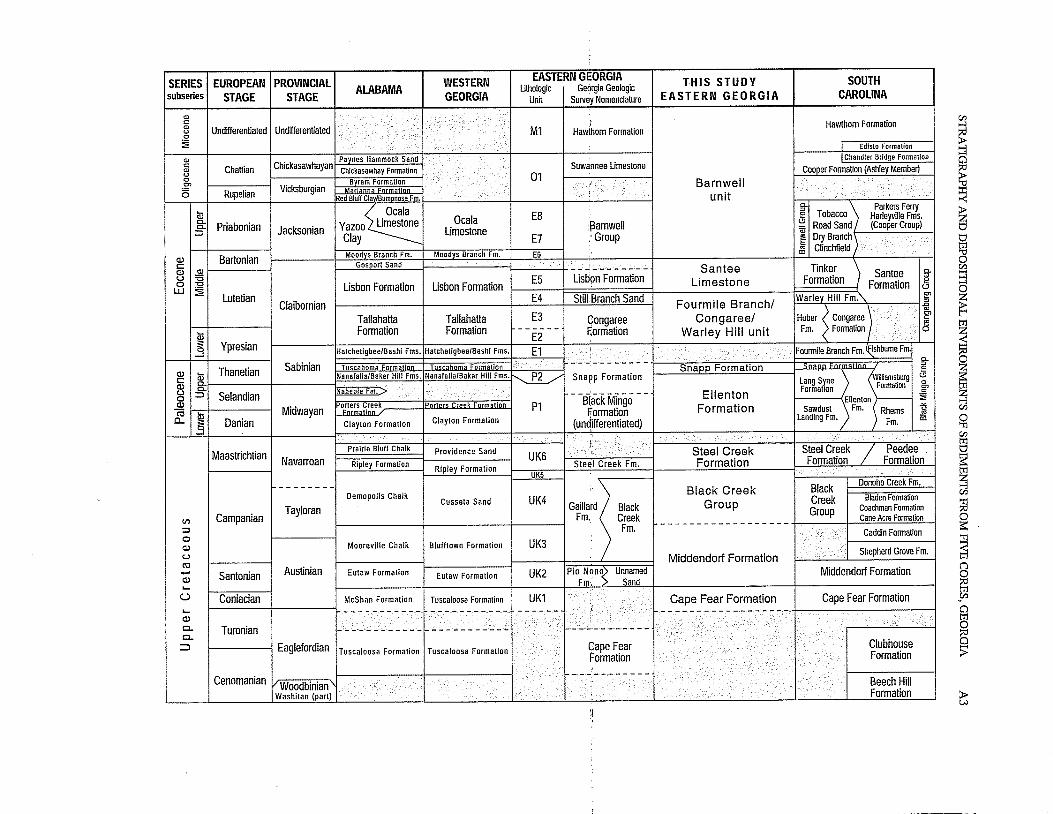
Figure 2. Generalized comparison of Cretaceous and >Tertiary geologic units in the Southeastern United States(modified from Clarke and others, 1994). Shaded areas indicatemissing stratigraphic sections. Dashed lines indicate formationboundary of uncertain stratigraphic position. Abbreviationused: Fm, formation. Source for the lithoiogic units of easternGeorgia: Prowell, Christopher, and others (1985). Sources forthe Georgia Geologic Survey nomenclature in eastern Georgia:Huddlestun and Hetrick (1991), Summerour and others (1994),and Huddlestun and Summerour (1996). Sources for units ofSouth Carolina: Colquhoun and others (1983), Gohn (1992),and Fallaw and Price (1995).
The five test holes informally are named for local landmarks and formally are assigned either a GGS or a USGSidentification number. The informal names used in thisreport are Millhaven, Girard, Thompson Oak, Millers Pond,and McBean. The five test holes were continuously coredwith a wireline, mud-rotary coring system. The cores fromthe Millhaven, Girard, and Millers Pond test holes wereexamined for texture, mineralogy, sedimentary structures,diagenetic features, and the presence of macrofossils.Selected samples were examined microscopically fordinoflagellates, pollen, foraminifers, ostracodes, and calcareous nannofossils. The descriptions of the cores and thegeophysical logs of the associated test holes at Millhaven,Girard, and Millers Pond are the primary sources of information for the following discussion of stratigraphic units(Clarke and others, 1994, 1996; Leeth and others, 1996).
The authors interpreted the stratigraphy of the Thompson Oak and McBean cores from descriptions published bythe GGS (Huddlestun and Summerour, 1996) and have notpersonally examined these cores in detail. Samples for paleontologic examination were collected by P.E Huddlestun of·the GGS from the Thompson Oak and McBean cores. Weused the paleontologic results (Frederiksen and others, thisvolume, chap. C; Edwards, this volume, chap. G; Frederiksen, this volume, chap. H) to interpret the stratigraphy andsedimentation of geologic units in the updip area near Millers Pond in Burke County, Ga. The stratigraphies of thesetwo cores supplement the following discussion of stratigraphy in the updip part of Burke County near the Millers Pondtest hole but are not illustrated as stratigraphic columns inthis report.
Geophysical-logging surveys of the test holes, with theexception of the McBean test hole, include single-point andtriple-point electric resistance, spontaneous potential, natural gamma ray, and hole diameter (caliper log). Formationinstability and hole diameter of the Millhaven test hole prevented electric-logging surveys of the section from 571 to530 ft and triple-point resistance logging below 900 ft. TheMcBean test hole is the only one studied that was not geophysically logged.
o 10 20
o 10 20IMtli\~"'! I !
/,/'
/'
,\-1 Jefferson',--
\\,('
33'
MlIlhaven• Test hole site and intoOTlat name at site-'.... . .. . .-'_.. "'-. ... ...
Figure 1. Index map showing the Savannah River Site and thelocation of stratigraphic test holes in the study area.
32'30''----.JL.- -'-- -'- ---.J
1,450 ft thick in the downdip Millhaven core in ScrevenCounty.
Previously, the Upper Cretaceous section in the subsurface of the study area was penetrated partially by fourcored test holes along the Savannah River in Burke County(Bechtel Corporation, 1972) and by a cored test hole nearthe town of Midville in the southwestern corner of BurkeCounty (Prowell, Christopher, and others, 1985). The Cretaceous section also was studied by using geophysical logsand cuttings from local water wells (Clarke and others,1985). The sedimentary history and stratigraphy of the Tertiary section in the study area already were known from outcrops (Huddlestun and Hetrick, 1978, 1979, 1986; Hetrick,1992) and from several fully or partially cored test holes innorthern Burke County (McClelland, 1987) and along theSavannah River in Burke and Screven Counties (BechtelCorporation, 1972).
This chapter briefly describes the lithologic and stratigraphic character of the geologic units (fig. 2) recognized inthe five cored sections to provide a framework for detaileddiscussions of the fauna and flora identified from paleontologic efforts. The paleontologic data presented in the otherchapters of this volume are used with the core descriptionsto infer correlation of these geologic units with stratigraphically equivalent units in the vicinity of the study area and toinfer depositional environments.
33'30'
i
SERIES EUROPEAN PROVINCIAL WESTERN EASTERN GEORGIA THIS STUDY SOUTHALABAMA lithologic Georgia Geologicsubseries STAGE STAGE GEORGIA Unit Survey Nomenclature EASTERN GEORGIA CAROLINAQlc: i Hawthorn FormationQl Undifferentiated Undifferentiatedu ." Ml Hawthorn Formation0
~ , .. ' I Edisto FormationQl
ChickasawhayanPaynes Hammock Sand . IChandler Bridge Formation
c: Chattian Suwannee limestoneQl Chickasawhay Formation Cooper Formation (Ashley Member)u 010 Bvram Formation ! Barnwell.S!' Vicksburgianis Rupelian Red Bluff Cia IBumonose Fm. unita;
~~E8 i Tobacco \
Parkers Ferry0- Yazoo Limestone Ocala Harleyville Fms.0- Priabonian Jacksonian Limestone :!3arnwell = RoadSand (Cooper Group)
::::l Clay E7 .' Group ~ Dry Branch
Bartonian Moodvs Branch Fm. Mood s Branch Fm. E6 ~ Clinchfield .Q) Gosoon Sandc::: _._-- -,-'-'_.. _--"_ ..- Santee TinkerQ) Q) Santee C1.u '6 E5 Lisb'on Formation Limestone Formation ::J0 "C Lisbon Formation Lisbon Formation Formation e
LJJ ~ t.:lLutetian E4 Still.Branch Sand Warley Hill Fm."- g>
Claibornian Fourmile Branch! ::J.c'"Tallahatta Tallahatta E3 Gonga~ee Congaree! Huber ~ Congaree )Clc:~
a; Formation Formation ------ RormatIon Warley Hill unit Fm. Formation 0
s YpresianE2 ....
0 Halchetigbee/Bashi Fms. Hatcheligbee/Bashi Fms. El ! .... .'. Fourmile Branch Fm.qishbumeFm.--' .. , ..... ....._.. C1.
Thanetian Sabinian =FO Snapp Formation ::JQ) a; ker Hill Fms. NanafalialBaker Hlii Fms.NU ec::: Snapp Formation Lang Syne 2.. <WiliiamSburg t.:lQ) 0- 0
0- Naheola Fm. > Formallon Formallon Clu ::::l Selandian Ellenton .50 - -Biack Mingo - - 511enlon }--- ::;;Q)
pOJ~;:;.~~~ek Porlers Pl -'"ro Midwayan Formation Formation Sawdusl Fm. Rhems u
j .!!l0.. Danian Clayton Formalion Clayton Formation (un~ifferentiated)Landing Fm. Fm. CD
... ' .. ......
Maastrichtian Prairie Bluff Chalk Providence Sand " Steel Creek Steel Creek / PeedeeNavarroan Ripley Formation UK6
Stelll Creek Fm. Formation Formation FormationRipley FormalionUK5 ....
-------- Black Creek Black Donoho Creek Fm.Demopolis Chalk Cussela Sand UK4 Group Creek Bladen Formation
Tayloran G.m",~ "". Group Coachman FormationfJ'l Campanian Fm. Creek Cane Acre Formation:::l . Fm. ------------------ ... Caddin Formation0Q) Mooreville Chalk Bluiitown Formalion UK3u Middendorf Formation ..... Shepherd Grove Fm.ctl- Santonian Austinian Eulaw Formalion Eutaw Formalion UK2 Pio Non~ Unnamed Middendorf FormationQ) Fm, Sand...u Coniacian McShan Formation Tuscaloosa Formalion UKl Cape Fear Formation Cape Fear Formation....... '-.Q)
" ' .... .' ic.. Turonian -- -- --:"1'c.. .....
:::J Eaglefordian Cape Fear ClubhouseTuscaloosa Formation Tuscaloosa FormalionFormation Formation
' .. ! - -.-.-Cenomanian Woodbinian I···. J .'.Beech Hill
Washilan (part) . .. Formation
A4 GEOLOGY AND PALEONTOLOGY OF FIVE CORES FROM SCREVEN AND BURKE COUNTIES, GEORGIA
The Millhaven test hole was drilled by the USGS inlate 1991 and early 1992 and formally designated as33X048 (Clarke and others, 1996). The Millhaven site islocated in Screven County, Ga., at lat 32°53'25" N., long81°35'43" W. (fig. 1) and has a land surface elevation of 110ft. The test hole was drilled from land surface to a totaldepth of 1,452 ft (fig. 3). This test hole was terminated inUpper Cretaceous sediments of the Cape Fear Formationand did not reach pre-Cretaceous rocks.
The USGS drilled the Girard test hole in the spring of1992 and formally designated it as 32Y020 (Leeth and others, 1996). The Girard site is in Burke County, Ga., at lat33°03'54" N., long 81°43'13" W. (fig. 1) and has a land surface elevation of 250 ft. The test hole was drilled from landsurface to a total depth of 1,385 ft and penetrated 1,375 ft ofcoastal plain sediments (fig. 4) and 10 ft of continental redbeds of probable Triassic or Jurassic age (Siple, 1967;Marine, 1979; Prowell, Christopher, and others, 1985).
The GGS drilled the Thompson Oak test hole in early1993 and formally designated it as GGS-3794 (Summerourand others, 1994; Huddlestun and Summerour, 1996); it isalso knowrFas-TR92-6 and' Burke -12. The drill-site islocated in Burke County, Ga., at lat 33°10'42" N., long81°47'10" W. (fig. 1) and has a land surface elevation of 240ft. The test hole was drilled from land surface to a totaldepth of 1,010.5 ft and penetrated 996 ft of coastal plainsediments and 14.5 ft of biotite gneiss of probable Paleozoicage.
The GGS drilled the Millers Pond test hole, alsoknown as Burke 2, in the summer of 1991 and formally designated it as GGS-3758 (Clarke and others, 1994). The siteis located in Burke County, Ga., at lat 33°13'48" N., long81°52'44" W. (fig. 1) and has a land surface elevation of 245ft. The test hole was drilled from land surface to a totaldepth of 859 ft and penetrated 852 ft of coastal plain sediment (fig. 5) and 7 ft of biotite-hornblende gneiss of probable Paleozoic age. A nearby hole, Millers Pond test well 1,was logged for geophysical properties.
The GGS drilled the McBean test hole, also known asBurke 5, in 1991 and formally designated it as GGS-3757(Summerour and others, 1994; Huddlestun and Summerour,1996). The drill site is near the community of McBean inBurke County, Ga., at lat 33°13'38" N., long 81°55'50" W.(fig. 1) and has a land surface elevation of 297 ft. The testhole was drilled from land surface to a total depth of 327 ftand terminated in the upper part of the Upper Cretaceoussection.
Stratigraphic tops, stratigraphic details, and samplesfor paleontologic analysis in this volume are reported ascore depth below land surface. Geophysical logs for theMillhaven, Girard, and Millers Pond test holes wereadjusted slightly to match core depth.
PREVIOUS WORK
Previous reports on the geology of Burke and ScrevenCounties and adjacent areas of Georgia include those byVeatch and Stephenson (1911), Brantley (1916), Cooke andShearer (1918), Cooke (1943), LaMoreaux (1946a,b),LeGrand and Furcon (1956), Herrick (1960, 1961, 1964,1972), Herrick and Vorhis (1963), Herrick and Counts(1968), Bechtel Corporation (1972, 1973), Carver (1972),Buie (1978), Huddlestun and Hetrick (1978, 1979, 1986,1991), Prowell and O'Connors (1978), Schroder (1982),McClelland (1987), Huddlestun (1988, 1992), Hetrick(1992), Clarke and others (1994, 1996), Huddlestun andSummerour (1996), Leeth and Nagle (1996), Leeth andothers (1996), and Falls and others (1997). Geologic reportson Burke and Screven Counties and adjacent parts of SouthCarolina include those by Snipes (1965); Hurst and others(1966); Scrudato and Bond (1972); Daniels (1974); Marineand Siple (1974); Bechtel Corporation (1982); Faye andProwell (1982); Huddlestun (1982); Prowell, Christopher,and others (1985); Colquhoun (1991, 1992); Edwards(1992); Fallaw and Price (1992, 1995); Harris and Zullo
=(1992); and Pro~e.lJ (1994). G~910gj~.r~PQrt!i o~ adjacentparts of South Carolina include those by Sloan (1908);Cooke (1936); Cooke and MacNeil (1952); Christl (1964);Siple (1967); Marine (1979); Smith (1979); Nystrom andWilloughby (1982); Zullo and others (1982); Colquhounand others (1983); Bledsoe (1984, 1987, 1988); Colquhounand Steele. (1985); Steele (1985); Prowell, Edwards, andFrederiksen (1985); Nystrom and others (1986, 1991);Dennehy and others (1989); Logan and Euler (1989);Robertson (1990); Colquhoun and Muthig (1991); Price andothers (1991); Fallaw and others (1992a,b); Snipes andothers (1993); and Gellici and others (1995).
ACKNOWLEDGMENTS
The authors thank the U.S. Department of Energy forits support of this investigation. They also thank the GeorgiaGeologic Survey for allowing access to the Millers Pondcore, and Paul F. Huddlestun for sampling and providinglithologic descriptions of the Thompson Oak and McBeancores. The authors also acknowledge the efforts of DonaldG. Queen, Eugene F. Cobbs, and Gerald E. Idler during thecoring and logging of the Millhaven and Girard sites.
STRATIGRAPIDC FRAMEWORK
Lithologic data from the Millhaven, Girard, and Millers Pond cores and geophysical logs from the three associated test holes were used to define the four Cretaceous andfive Tertiary units in this study (fig. 2). Correlation of thesegeologic units in the Millhaven, Girard, and Millers Pondcores is presented in a dip-oriented cross section (fig. 6).
STRATIGRAPHY AND DEPOSITIONAL ENVIRONMENTS OF SEDIMENTS FROM FIVE CORES, GEORGIA AS
Geologicunit
Single-pointLithology resistance (ohms)
100 200
Gamma ray(API units)o 150-l--::----l..--.",....,._..--J.- J.--r- .,-Oo
1452 ..J.._.=:.- .t='-=';,.;'.I--- -L. .L. 1452
Land Surface Elevation = 110 feet above sea level.
Clayey sand
Limestone
Marl
Sandylimestone
Sand
Laminated clay
Massive clay
EXPLANATIONFOR FIGURES 3-5
~p:::p:;;:q~
~
~
~~~
~~
Figure 3. Gamma-ray, single-point resistance,and lithologic logs and geologic units of theMiIihaven test hole in Screven County, Ga.Abbreviation used: API, American PetroleumInstitute.
800
500
200
1000
1100
900
300
600
100
1200
1400
700
1300
Bamwellunit
MiddendorfFormation
Black CreekGroup
SnappFormation
EllentonFormation
SanteeLimestone
Steel CreekFormation
CapeFear
Formation
'"=e".0"lI)
'"';:".0"lI)
,-'
-;..:"=------~~J+----+-----ll__..__,,,.___.,.,..---r400", FourmileI ~ Branch/
_ ~ Congaree/§ Warley Hili() unit
600
900
200
500
400
800
300
700
100
1100
1200
1000
1300
1400
A6 GEOLOGY AND PALEONTOLOGY OF FIVE CORES FROM SCREVEN AND BURKE COUNTIES, GEORGIA
O-!---::o=-.1.----,-----:--..,,---1 ---1_,- -,-
Gamma ray(API units)o 150
Single-pointLithology resistance (ohms)
100 200
Geologicunit
o
1300
1200
CapeFear
Formation
Land Surface Elevation =250 feet above sea level.
-'-_-==- -L:.:=-'==l.---l'-- ---lL..- -L 1375
1200
1300
1375
Figure 4. Gamma-ray, single-point resistance, and lithologic logs and geologic units ofthe Girard test hole in Burke County, Ga.Abbreviation used: API, American PetroleumInstitute. Lithologic patterns are explained infigure 3.
100 100Barnwell
unit
200 200
Santee300 Limestone 300
'"Fourmile
c: Branch!0u Congareel400 ::;;..: Warley Hill 400
LL<Il unit
SnappFormation
500 Ellenton 500Formation
, _.•.:.._- .._.~ -,"
Iii Steel Creekwu. 600 Formation 600~
u.iu'"U': C0:: ;:l
::> 700 .0 700;:lCI) UI
0z::ss: Black Creek0 800 '" Group 800...JW ~!II ;:l
:r: .0;:l
l- UI0-W0
900 900, ~.0_
~ '§
1000 '" 1000~;:l.0;:lUI
MiddendorfFormation
1100 1100
STRATIGRAPHY AND DEPOSITIONAL ENVIRONMENTS OF SEDIMENTS FROM FIVE CORES, GEORGIA A7
Gamma ray(API units)o 150
LithologySingle-point
resistance (ohms)175 200
Geologicunit
O-l--.::---..L---,.,....,.-:-'"7T""--I..----L,,--------,-O
500
600
700
200
400
300
100
MiddendorfFormation
Cape FearFormation
Bamwellunit
SanteeLimestone
EllentonFormation
Black CreekGroup
Steel CreekFormation
Fourmile Branch!Congareel
Warley Hill unitSnapp
Formation
Land Surface Elevation 245 feet above sea level.
Figure 5. Gamma-ray, single-point resistance,and lithologic logs and geologic units of the
800 Millers Pond test well 1 and test hole in BurkeCounty, Ga. Abbreviation used: API, American
852 .-L-.:::.~ =-=~s:... __l _l_ 852 Petroleum Institute. Lithologic patterns areexplained in figure 3.
800
700
500
400
600
300
200
100
The section roughly parallels the Savannah River andreflects the thicknesses and stratigraphy of the geologicunits from the updip Millers Pond site to the downdip Millhaven site. Datum for the section is sea level. The elevationand depth of the stratigraphic top of each geologic unit inthese three cores and the Thompson Oak and McBean coresare listed in table 1.
Prowell, Christopher, and others (1985) correlatedCretaceous and Tertiary geologic units in the updip coastalplain from central Georgia to western South Carolina. Theyidentified five of the six Upper Cretaceous units, two Paleocene units, six of the eight Eocene units, and one Oligocene unit in a South Carolina drill hole at the SRS (fig. 2).Their units were essentially chronostratigraphic units thatwere assigned alpha-numeric designations because of a lackof existing nomenclature. Subsequently, Fallaw and Price(1995) established a working nomenclature and describedthe stratigraphic units beneath the SRS. The stratigraphy
and nomenclature used in this report result from combininginformation from these reports.
Huddlestun and Hetrick (1991), Summerour and others(1994), and Huddlestun and Summerour (1996) proposed astratigraphic nomenclature for the updip part of the studyarea in east-central Georgia. A comparison of the stratigraphic units for previous studies with the stratigraphy inthis study is shown in figure 2. The stratigraphy of the Millhaven, Girard, and Millers Pond cores is shown in figures 3,4, and 5.
CRETACEOUS STRATIGRAPHY
The Cretaceous sediments in the study area are dividedinto the Cape Fear Formation, the Middendorf Formation,the Black Creek Group, and the Steel Creek Formation (fig.2). These four geologic units consist of siliciclastic sediments, are coarser grained and more oxidized in updip
o 5 10 MILESI ! I
300
200
100
SEAEVEL
100
200
-' 300w>w-'L1i 400en0I-W> 500
~wa: 600Iiiwu..6; 700Z0
~ 800w-'w
900
1000
1100
1200
1300
1400
I MILLERS POND IResistance
EXPLANATION
~ Umeslane
~~~~~oneMarl
Masslveclay
laminated clay
~sandL:..:..:JClayey send
I GIRARD IGamma ray Ulhology Re:slslance
Iloll/""","((IJN/~
"""""'"
300
I MILLHAVEN I -1200
Resistance
100
SEA
100
200
300
400
500
600
700
800
900
1000
1100
1200
1300
1400
;l>-00
~~
~
I~~
~
~~lZl
~~
~
iSf.!
IFigure 6. Gamma-ray, single-point resistance, and lithologic logs (from figs. 3-5)~howing dip-oriented correlation of geologic units from the Millers Pondtest hole to the Millhaven test hole. Datum is sea level. .
STRATIGRAPHY AND DEPOSmONAL ENVIRONMENTS OF SEDIMENTS FROM FIVE CORES, GEORGIA A9
Thble 1. Elevations and depths of stratigraphic tops for geologic units and subunits in the Millhaven, Girard, Thompson Oak, MillersPond, and McBean cores.
[The stratigraphic contacts in the Thompson Oak and the McBean cores are interpreted from lithologic descriptions provided by Paul F. Huddlestun, GeorgiaGeologic Survey, Atlanta, Georgia. The stratigraphic contacts and names for the Thompson Oak and McBean cores in this table represent the stratigraphicinterpretations of the authors and do not agree with Huddlestun's interpretations in all cases. Elevations are in feet above or below sea level. Depths are in feetbelow land surface. Top of Barnwell unit equals land surface in each core. N.D., not determined; N.P., not penetrated]
Elevation/depth of stratigraphic contact
Name of geologic unitMillhaven Girard Thompson Oak Millers Pond McBean
core core core core core
Barnwell unit--------------------------------------- 110/0 250/0 240/0 245/0 297/0Santee Limestone---------------------------------- -118/228 01250 1101130 163/82 185/112Founnile BranchfCongaree/ Warley Hill unit - -291/401 -75/325 58/182 89/156 111/186
Warley Hill Formation ------------------------ -291/401 absent absent absent absentCongaree Formation -------------------------- -352/462 -75/325 58/182 89/156 1111186Founnile Branch Formation ----------------- absent -140/390 -111251 absent absent
Snapp Formation ---------------------------------- -394/504 -173/423 absent 80/165 75/222Ellenton Formation-------------------------------- -460/570 -231/481 -34/274 13/232 251272Steel Creek Formation ---------------------------- -532/642 -292/542 -84/324 -39/284 -8/305Black Creek Group-------------------------------- -729/839 -392/642 -166/406 -87/322 N.P.
Subunit 3 --------------------------------------- -729/839 -392/642 -166/406 -87/322 N.P.Subunit 2 --------------------------------------- -817/927 -482/733 N.D. N.D. N.P.Subunit i' --------------~------~-~--~---~~':------ -1,009/1,119 -659/909 N.D. N.D. N.P.
Middendorf Formation --------------------------- -1,062/1,172 -708/958 -445/685 -347/592 N.P.Subunit 2 --------------------------------------- -1,062/1,172 -708/958 -445/685 -347/592 N.P.Subunit 1 --------------------------------------- -1,162/1,272 -812/1,062 -485/725 -418/663 N.P.
Cape Fear Formation ----------------------------- -1,269/1 ,379 -913/1,163 -602/842 -5071752 N.P.Bedrock--------------------------------------------- N.P. -1,125/1,375 -756/996 -603/852 N.P.
areas, and become finer grained in a coastward direction.Unit contacts are typically overlain by Jags of very poorlysorted sand containing granules, pebbles, and lithoclasts.Each contact is considered to be a regional unconformityand probably denotes a considerable hiatus in sedimentation. In the updip area, lithologic similarities among theunits and the presence of only a few fossil-bearing bedsmake it difficult to identify unit contacts at Millers Pond.Evidence of possible unconformities is used to divide theMiddendorf Formation into two subunits in the Millhaven,Girard, and Millers Pond cores, and the Black Creek Groupinto three subunits in the Millhaven and Girard cores. Prowell, Christopher, and others (1985) identified units UKIthrough UK6 in their study but did not correlate their unitUK3 with units in the test holes at the SRS.
Biostratigraphic studies by Christopher (1978) andProwell, Christopher, and others (1985) suggested that Cretaceous strata in east-central Georgia ranged in age fromConiacian to Maastrichtian. The sediments in the four unitshave been interpreted as parts of large deltaic systems thatprograded across the paleo-continental shelf in east-centralGeorgia and western South Carolina (Prowell and others,1985a; Fallaw and Price, 1995). Lithofacies observed in theUpper Cretaceous units accumulated in coarser grainedproximal and finer grained distal deltaic settings.
CAPE FEAR FORMAnON
The Cape Fear Formation consists of partially lithifiedto unlithified, poorly to very poorly sorted clayey sand andsandy clay with a few beds of silty clay. The sand is fine tovery coarse with granules and pebbles and is predominantlyangular to subangular quartz with some feldspar. Cristobalite in the clay matrix results in lithologies that are harderand denser than sediments in the other Cretaceous units.The cristobalitic clay matrix imparts a yellowish-green togreenish-gray color to most of the lithologies and occludesmost of the intergranular porosity in the sand beds. Electriclogs display low resistance in the sands and the clays inmost of this unit. Sands in the upper 10 to 20 ft of this unitin the Millhaven and Girard cores are unlithified and haveatypically high resistance values on the electric logs.
The Cape Fear Formation contains multiple finingupward cycles that range in thickness from 3 to 15 ft. Eachcycle grades upward from a basal coarse pebbly sand toclayey sand or clay. The clays are oxidized and are generallystained with reddish-brown and yellowish-brown patches ofiron oxide. A root-trace pattern is present at the top of a fewof the fining-upward cycles and at the top of this unit in theMillhaven core. Sediments directly beneath the upper contact of the Cape Fear Formation in the other cores are
AIO GEOLOGY AND PALEONTOLOGY OF FIVE CORES FROM SCREVEN AND BURKE COUNTIES, GEORGIA
stained with iron oxides. Lag deposits at the base of theCape Fear Formation contain clasts of saprolitic gneiss inthe Millers Pond core and clasts of Triassic siltstone in theGirard core.
Most of the strata in this unit are barren of fossils, but afew samples of gray and olive-gray, silty clay from the Millers Pond core yielded low-abundance and low-diversity pollen assemblages. Palynologic analysis of these samplesfrom the Millers Pond core (Frederiksen and others, thisvolume, chap. C) indicates a Coniacian microflora that isconsistent with the microflora of the Cape Fear Formationof South Carolina and North Carolina (Christopher and others, 1979; Christopher, 1982; Sohl and Owens, 1991). Prowell, Christopher, and others (1985) and Fallaw and Price(1995) suggested a Santonian age for unit UK1 and theCape Fear Formation at the SRS. Huddlestun and Summerour (1996) suggested that the Cape Fear Formation is equivalent to the Cenomanian-Turonian Tuscaloosa Formation ofwestern Georgia. Samples from this formation were not processed for the other cores.
The presence of a terrestrial microflora and theabsence of dinoflagellates and other marine fossils in theCape Fear· Formation "suggest deposition in a nonmarine - .environment at Millers Pond. The Cape Fear Formation inthe Millhaven and Girard cores is lithologically similar tothe section in the Millers Pond core and also is interpretedas having been deposited in a nonmarine environment. Themultiple fining-upward cycles, the coarse texture of thesands, the iron-oxide staining, and root-trace patterns in theclays suggest that most of this unit was deposited in channeland overbank environments during aggradation of a fluvially dominated, subaerially exposed part of a delta-plainenvironment.
MIDDENDORF FORMATION
The Middendorf Formation consists predominantly ofunlithified sand, which is locally fine to very coarse or fineto medium quartz (figs. 3, 4, 5). The sand includessmoky-quartz granules and pebbles, mica, lignite, and generally very little clay matrix. The Middendorf sands aremoderately to poorly sorted and are very porous and permeable in comparison with the sands in the underlying CapeFear Formation. Black clay is present in laminae and thinbeds that are less than 2 ft thick in the Millhaven core. Claybeds in the Millers Pond core and most of the Girard coregenerally are light gray to white and range in thickness from1 to 10 ft.
The Middendorf Formation contains two distinct subunits in the Millhaven, Girard, and Millers Pond cores.Additional work in the study area may show these subunitsto be separate, mappable formations. At present, they areinformally referred to in ascending order as subunits 1 and 2of the Middendorf Formation. Each subunit includes a basal
lag deposit of poorly sorted sand that grades up to interbedded and interlaminated clay and sand. Micaceous and lignitic sand laminae are common in the Middendorf sections,particularly near the top of each subunit. Clay beds are generally thicker and display more abundant iron-oxide stainingnear the top of each subunit in the Millers Pond and Girardcores. A root-trace pattern is observed in the clay at the topof subunit 2 in the Girard core. Clays at the top of each subunit in the Millhaven core are not stained with iron oxides.
Lithologic data and geophysical log patterns seem toindicate that the upper contact of the Middendorf Formationin the Georgia cores correlates with the unit UK2/UK4boundary of Prowell, Christopher, and others (1985) and thetop of the Middendorf Formation as recognized by Fallawand Price (1995) at the SRS. A Santonian age was reportedfor unit UK2 by Prowell, Christopher, and others (1985) andfor the Middendorf Formation at the SRS by Fallaw andPrice (1995). Samples collected at 1,138 and 1,012 ft in theGirard core and 1,212 ft in the Millhaven core containpollen that suggests at least part of the MiddendorfFormation may be correlative with the Shepherd GroveFormation, which overlies the Middendorf in SouthCarolina (Frederiksen and others,this volume, chap.cG).
All or part of what has been described as MiddendorfFormation in this part of Georgia may actually be correlative with part of the Black Creek Group or an updip lithofacies of either the Caddin or Shepherd Grove Formations,which Gohn (1992) identified as late Santonian to earlyCampanian in age. Evidence of subaerial exposure and erosionallags at the contacts between the upper and lower subunits support the possibility that unit UK2 (Prowell,Christopher, and others, 1985), as defined beneath thesoutheastern comer of the SRS, contains more than one depositional sequence and is equivalent in part to unit UK3.
Huddlestun and Hetrick (1991) applied the name PioNono Formation in updip areas of east-central Georgia tothe Middendorf Formation as used here. Dinoflagellates andother marine indieators are sparse and suggest a marginal-marine environment at Millhaven and a nonmarineenvironment for this unit in the other cores.
BLACK CREEK GROUP
The Black Creek Group consists of three distinct subunits in the Millhaven and Girard cores: a basallignitic sandin subunit 1, a laminated black clay and sand in subunit 2,and a coarsening-upward sand sequence in subunit 3 (figs.3, 4, table 1). The lag deposits at the bases of the subunitssuggest the possibility of unconformities in the Black CreekGroup at Millhaven and Girard. The Black Creek Group atMillers Pond is coarser and sandier and is not divided intosubunits (fig. 5).
Black Creek subunit 1 consists of moderately to poorlysorted, fine to coarse quartz sand that grades into overlying
STRATIGRAPHY AND DEPOSmONAL ENVIRONMENTS OF SEDIMENTS FROM FIVE CORES, GEORGIA All
very fine to fine sand with a few thin beds of clay. The sandcontains abundant interlaminated fine lignite and mica andvery little clay matrix. This subunit is lithologically verysimilar to the underlying Middendorf Formation.
Black Creek subunit 2 in the Millhaven core has asharp basal contact at 1,119 ft and a second sharp contact at1,099 ft. Each contact is overlain by a basal lag deposit ofvery poorly sorted sand. The sand above the contact at 1,099ft grades and fines into an overlying 161-ft section of predominantly silty laminated black clay. The 161-ft clay section also includes very fine to fine sand from 1,063 to1,051 ft. Most of subunit 2 is calcareous and contains laminae and lenses of very fine sand and sand-filled burrows.Very fine to fine sand is interlaminated at the top of the clayfrom 934 to 927 ft. Subunit 2 in the Girard core is sandierand consists of very fine to fine sand with interbedded blackclay. The sand at Millhaven and Girard includes mica, lignite, and minor amounts of glauconite.
Bioturbation features in subunit 2 at Millhaven andGirard include clay-lined burrows, mottled textures, and discontinuous laminae of clay in the sands. Subunit 2 at Millhaven and Girard yielded the most abundant and diversemarine macrofaunas and microfaunas and microfloras in the 'Cretaceous section in the study area, including shark teeth,pelecypods, ostracodes, benthic and planktonic foraminifers, spicules, dinoflagellates, pollen, and calcareous nannofossils (Bukry, this volume, chap. D; Frederiksen andothers, this volume, chap. C; Gohn, this volume, chap. E).
Black Creek subunit 3 in the Millhaven core is a coarsening-upward sequence and consists of a very poorly sortedlag deposit from 927 to 926 ft; moderately to well-sorted,very fine to medium sand from 926 to 880 ft; and moderately sorted, fine to coarse sand from 880 to 826 ft. Thissubunit at Millhaven includes laminae and thin beds ofdark-gray clay, large and small pieces of lignite, and mica;the subunit is crossbedded from 907 to 900 ft.
Black Creek subunit 3 in the Girard core has a sharpbasal contact at 733 ft and a lag deposit of very poorlysorted sand and granules from 733 to 730 ft. The sectionincludes beds of moderately to poorly sorted, medium tovery coarse sand; and moderately sorted, fine to mediumsand with 5 to 10 percent clay matrix. This section is crossbedded from 714 to 710 ft and 679 to 660 ft and includesone light-gray, iron-stained clay from 685 to 679 ft. The topof the clay at 679 ft is overlain by a lag deposit of verypoorly sorted sand and granules.
The Black Creek Group at Millers Pond containspoorly sorted, fine to very coarse sand and beds of clay (fig.5). Granules and pebbles are more abundant and form several very poorly sorted lags at the base of sand beds, whichgenerally include clay clasts. The sand is unlithified and hasminor amounts of clay matrix. The tops of clay beds generally are stained with yellow and red iron oxides.
Paleontologic data from the studied cores suggest aCampanian age for the Black Creek Group (Frederiksen and
others, this volume, chap. C; Bukry, this volume, chap. D;Gohn, this volume, chap. E). Units UK4 and UK5 (Prowell,Christopher, and others, 1985) and the Black Creek Groupat the SRS (Fallaw and Price, 1995) are assigned an age ofCampanian to Maastrichtian. Huddlestun and Hetrick(1991) applied the name Gaillard Formation to the fluviallithofacies in the updip Georgia Coastal Plain. Paleontologicdata (Frederiksen and others, this volume, chap. C; Bukry,this volume, chap. D; Gohn, this volume, chap. E) suggestthat the calcareous lithologies of subunit 2 at Millhaven areequivalent to the Donoho Creek Formation of the BlackCreek Group (Owens, 1989; SoW and Owens, 1991).
The diversity and abundance of dinoflagellates, theabundance of marine faunas, and the presence of glauconiteat Millhaven and Girard suggest a strong marine influenceduring the deposition of subunit 2, probably in the distalpart of a deltaic complex. Dinoflagellates in subunit 3 suggest a marginal-marine depositional environment. The composition of the microflora and the absence of other marineindicators suggest that subunit 1 at Millhaven and Girardand the entire section of the Black Creek Group at MillersPond reflect sedimentation in a nonmarine part of the delta(Frederiksen and others; this volume, chap.q~ _.. 0 'co
STEEL CREEK FORMATION
Most of the Steel Creek Formation in the Georgia testholes consists of poorly to very poorly sorted, fine to verycoarse sand with granules and pebbles of smoky quartz and5 to 15 percent clay matrix (figs. 3, 4, 5). The basal lags areoverlain by thick intervals of oxidized clay in the Millhavenand Girard cores. Steel Creek sections include multiple fining-upward sequences with beds of coarser grained sandthat become finer and grade into overlying clay beds. Manyof the clay beds are stained with iron oxide and contain asmuch as 40 percent sand by volume. Root traces typicallyare present at the top of the thick oxidized clay near the baseof the section and in some of the clay beds near the top ofthis unit. Crossbedding is common at Millhaven. Ligniteand mica are common accessory constituents.
Kidd (1996) used a subtle difference in grain size andclay content and geophysical-log correlations with test holeson the SRS to identify the contact between the Black CreekGroup and the Steel Creek Formation at 397 ft in the MillersPond core. Huddlestun and Summerour (1996) identifiedthe basal contact at 367 ft in the Millers Pond core and 414ft in the Thompson Oak core; they described the contactbetween the Black Creek (Gaillard) and Steel Creek Formations as either conformable or paraconformable in updipparts of Burke County and as gradational in the Girard core.The contact between the Black Creek Group and the SteelCreek Formation is recognized as an unconformity at theMillhaven and Girard sites. This boundary is placed at thesharp contact at 322 ft in the Millers Pond core in this report
A12 GEOLOGY AND PALEONTOLOGY OF FIVE CORES FROM SCREVEN AND BURKE COUNTIES, GEORGIA
on the basis of projecting the contact from the downdipGirard core.
Most of the sediments in the Steel Creek Formation arebarren of fossils. Thin beds of brownish-gray clay in theSteel Creek section of the Millhaven core yielded Cretaceous and Paleocene palynomorphs, but more diagnostictaxa were not recovered (Frederiksen and others, this volume, chap. C). The presence of dinoflagellates and Paleocene palynomorphs in samples collected from the SteelCreek section in the Millhaven core is discounted as contamination of the samples with drilling mud (Edwards andothers, this volume, chap. B). Paleontologic data from theunderlying Black Creek Group and the overlying EllentonFormation restrict the age of the Steel Creek Formation tothe Maastrichtian.
Prowell, Christopher, and others (1985) identified acorrelative section in wells at the SRS as middleMaastrichtian in age and designated it as unit UK6. Theyconsidered unit UK6 to be a biostratigraphic equivalent ofthe Providence Sand and part of the Ripley Formation in
.Georgia and the Peedee Formation in eastern SouthCarolina~(fig; 2). Fallaw and Price (1995) described-andnamed the Steel Creek Formation at the SRS. Huddlestunand Summerour (1996) also applied the name Steel CreekFormation to cored sections in east-central Georgia andconsidered the Steel Creek Formation to be earlyMaastrichtian.
Marine fossils, carbonate minerals, and glauconite areabsent from the Steel Creek sections of the studied cores.The coarse sediments, fining-upward sequences, indicationsof rooting, and iron-oxide staining suggest channel andoverbank deposits in a delta-plain environment.
TERTIARY STRATIGRAPHY
The Tertiary section in this report includes the Ellentonand Snapp Formations in the Paleocene strata and the Fourmile Branch/Congaree/Warley Hill unit, the Santee Limestone, and the Barnwell unit in the Eocene and youngerstrata (fig. 2). Each of the Eocene units in the Georgia corescan be lithologically, geophysically, or biostratigraphicallycorrelated with more than one formal formation in the studyarea and is informally named in the report.
The stratigraphy proposed by Prowell, Christopher,and others (1985) at the southeastern comer of the SRSincluded two Paleocene units designated as units PI and P2,six Eocene units designated as units E1, E3, E4, E5, E7, andE8, and an Oligocene unit designated as unit 01. Units E2,E6, and M1 were recognized and correlated in Georgia butwere not correlated with units in the southeastern comer ofthe SRS (prowell, Christopher, and others, 1985).
ELLENTON FORMATION
The Ellenton Formation in the Georgia cores is finergrained, calcareous, and very glauconitic in the downdipMillhaven and Girard cores. It is coarser grained and noncalcareous in the updip Millers Pond core (fig. 6). Lagdeposits and sharp bedding contacts identify basal unconformities and possible unconformities within the Georgiasections.
The Ellenton Formation in the Millhaven core consistsof glauconitic, calcareous, fine to coarse sand and laminatedclay from 642 to 622 ft; well-laminated, slightly calcareous,silty black clay from 622 to 595 ft; and calcareous to noncalcareous clay from 595 to 570 ft (fig. 3). The EllentonFormation in the Girard core consists of noncalcareous sandand black clay from 542 to 518 ft; sandy carbonate andlimestone and calcareous sand with abundant glauconitefrom 518 to 491 ft; and well-laminated, noncalcareous siltyclay from 491 to 481 ft (fig. 4). The section generally contains well-sorted, fine to medium quartz sand. The lagdeposits at 638, 625, and 595 ft in the Millhaven core and518 ft in the Girard core contain 10 to 20 percent glauconite,s~veral r:Olln<:ied _phosphati.c. cl~sts, =and shark. teeth..A.high-angle shear defines a sharp contact at 491 ft in theGirard core.
The Ellenton Formation in the updip Millers Pond coreconsists of fine to very coarse sand with interbedded sandyclay from 284 to 263 ft; interlaminated black lignitic clayand very fine to medium sand from 263 to 247 ft; and fine tomedium clayey sand from 247 to 232 ft (fig. 5). The laminated black clay is very dense and may contain as much as 5percent mica. Recovery of sediment in the Millers Pondcore was not as good as recovery in the Millhaven andGirard cores; however, poorly sorted pebble lag deposits at284 and 271 ft and clay clasts at 263 and 244 ft suggest possible unconformities and reworking of the Ellenton Formation in the Millers Pond core.
Paleontologic results suggest that the Ellenton Formation in this report is equivalent to unit PI (prowell, Christopher, and others, 1985) and the Ellenton Formation in SouthCarolina (Prowell, Edwards, and Frederiksen, 1985). Huddlestun and Summerour (1996) described a unit that theyidentified as the Black Mingo Formation undifferentiated inGeorgia. They recognized a lower and an upper unit thatresemble lithologies of the Rhems, Williamsburg, and LangSyne Formations of the Black Mingo Group (Van Nieuwenhuise and Colquhoun, 1982). Fallaw and Price (1995)divided the Ellenton section into the Sawdust Landing andLang Syne Formations in wells near the southeastern borderof the SRS. The noncalcareous, nonglauconitic sand andclay from 542 to 518 ft at Girard and from 284 to 263 ft atMillers Pond are lithologically similar to the Sawdust Landing Formation. However, a similar lithologic unit was notrecognized at Millhaven. The rest of the Ellenton Formationat Millhaven and Girard is similar to the very glauconitic
STRATIGRAPHY AND DEPOSmONAL ENVIRONMENTS OF SEDIMENTS FROM FIVE CORES, GEORGIA A13
and silty lithologies of the Lang Syne Formation. The carbonate component at Millhaven and Girard is not describedin the Lang Syne Formation at the SRS but is described aspart of this unit beneath Allendale County in South Carolina(Fallaw and Price, 1995; Gellici and others, 1995).
Paleontologic studies identified a diverse microflora ofdinoflagellates, pollen, and calcareous nannofossils and afaunal component of ostacodes, planktonic foraminifers,pelecypods, and gastropods in the downdip sections(Edwards and others, this volume, chap. B). The updip section at Millers Pond contains a low-diversity microflora ofdinoflagellates and pollen (Clarke and others, 1994). Themarine fossils, glauconite, and carbonate in downdip sediments indicate an open-marine environment, possibly distalprodelta. The low diversity and the low abundance ofdinoflagellates and the absence of other marine indicators atMillers Pond suggest a change to a more restricted marginal-marine environment.
SNAPP FORMATION
_, ..,._,Tb,~Sna.pp Form.a.tion..at.Millhaven, G~ar<;l, and. Mill:ers Pond consists of moderately to poorly sorted, fine tovery coarse sand overlain by iron-stained, oxidized kaolin(figs. 3, 4, 5). The sand is unlithified and generally has granules, pebbles, and less than 10 percent clay matrix. Individual sand beds typically are coarse to very coarse in the lowerpart of each section. In the middle of each section, the sandbeds are fine to medium. At the top of each section, the sandbeds grade into white to very light gray kaolin. The clay isstained with red and yellow iron oxides. Pedogenic structures in the otherwise massive clay include root traces anddesiccation cracks. Pyrite is disseminated in the clay andalong desiccation cracks near the top of the Snapp Formation in the Millers Pond and Girard cores.
The Snapp Formation in Georgia is equivalent to unitP2 (prowell, Christopher, and others, 1985) and the SnappFormation at the SRS (Fallaw and Price, 1995). McClelland(1987) applied the name Rhems Formation (lower Paleocene part of the Black Mingo Group) to a combined section of the Snapp and Ellenton Formations in upper BurkeCounty. The Snapp Formation holds the same upper Paleocene stratigraphic position as the Chicora Member of theWilliamsburg Formation of the Black Mingo Group (VanNieuwenhuise and Colquhoun, 1982). The Snapp Formationin the Georgia cores and in cores on the SRS (Fallaw andPrice, 1995) is lithologically different from the marine sediment of the Chicora Member.
The Snapp Formation is absent from the ThompsonOak core (fig. 1, table 1). Fallaw and Price (1995) describedan updip limit for the Snapp Formation near the UpperThree Runs Creek in Aiken County, S.C. Extension of thisboundary into Georgia would place the Thompson Oak corenear the updip limit of the Snapp Formation. The presence
of Snapp sediments in the McBean core indicates that theupdip limit is irregular in that it trends to the northwest fromthe Thompson Oak test hole across the northern part ofBurke County, Ga. (fig. 1).
Paleontologic samples were not collected from theSnapp Formation in the Girard and Millers Pond coresbecause of the extensive oxidation of the sediments. A sample from the base of this formation in the Millhaven coreyielded sparse dinoflagellates that are not age diagnostic(Edwards and others, this volume, chap. B). The stratigraphic position of this unit between the Ellenton Formationand the overlying early Eocene part of the FourmileBranch!CongareelWarley Hill unit suggests that the age ofthe strata is either late Paleocene (Prowell, Christopher, andothers, 1985; Fallaw and Price, 1995) or early Eocene (Harris and Zullo, 1992). Paleontologic data from a sample at264 ft in the McBean core indicated a Paleocene age; however, the authors have not independently verified that thesample at 264 ft is from the Snapp Formation. This sampleof the McBean core is above the base of the Snapp Formation as selected by Huddlestun and Summerour (1996).
Sedimentary characteristics suggest a fluvially dominated depOsitional environment in- -either' an uppetdeltaplain or an incised alluvial valley. The presence ofdinoflagellates in the Millhaven core suggests a marginal-marine environment in the downdip part of the studyarea. The Snapp Formation at Girard is 58 ft thick, which isroughly 20 ft thicker than the Snapp Formation in coresfrom the southeastern part of the SRS. The thicker sectionof the Snapp Formation in the Girard core overlies a sectionof the Ellenton Formation that is thinner by 20 ft relative tothe Ellenton section in the southeastern part of the SRS.Structural-contour and isopach maps of the Black Mingo(Ellenton) and Snapp Formations also indicate thicker sections of the Snapp Formation over thinner sections of theBlack Mingo (Ellenton) Formation in eastern Burke Countyand southern Barnwell County (Huddlestun and Summerour, 1996). This thickness change is interpreted here as evidence of channel incision of the Snapp Formation into thelaminated black clay of the Ellenton Formation.
FOURMILE BRANCHlCONGAREElWARLEY HILL UNIT
The lithologies of the Fourmile Branch!CongareelWarley Hill unit range from mixed-siliciclastic-carbonate sections in the central and downdip Georgia cores tosiliciclastic sections in the updip cores (figs. 3, 4, 5, 6).Paleontologic data suggest that the strata in this unit are correlative with three formally named formations at the SRS(fig. 2). However, all three formations are not consistentlypresent in each of the Georgia cores (table 1).
In the downdip Millhaven core, the Fourmile Branch!CongareelWarley Hill unit consists of interbedded quartzsand, marl, and limestone. The sand is very fine to fine
"."" .....
A14 GEOLOGY AND PALEONTOLOGY OF FIVE CORES FROM SCREVEN AND BURKE COUNTlES, GEORGIA
below a depth of 415 ft and fine to medium above a depth of415 ft and is moderately to well sorted throughout. Glauconite is a common accessory mineral and is abundant at 462ft. The carbonate beds range from lithified to unlithified andinclude glauconite, clay matrix and fossils. Extensive burrowing is recognized in the sandy carbonate matrix.
In the Girard core, this unit consists of medium tocoarse sand from 423 to 390 ft; fine to medium sand from366 to 350 ft; and medium to coarse sand, sandy carbonate,and limestone from 342 to 325 ft. A large part of the unitfrom 390 to 366 ft and several other parts of the sectionwere not recovered during coring. The section below 390 ftis predominantly noncalcareous with only trace amounts ofglauconite, generally less than 5 percent clay matrix, claylaminae, and clay-lined burrows. Unlithified sandy carbonate and partially lithified calcareous sand are abundantabove 366 ft.
This unit in the Millers Pond core consists of a 9-ftsection of well-sorted, very fine to fine sand. The sand contains less than 5 percent clay matrix, but clay-lined burrowsare present.
Surface mapping and drill hole evidence from thisupdip'region in"Georgia andadjaoent.areas of South Caro-·lina indicate a thicker section of sand and clay (Nystrom andWilloughby, 1982; Nystrom and others, 1986; McClelland,1987; Prowell, 1994). On the basis of data from augeredholes that are 1 mile west of the Millers Pond core site,McClelland (1987) described a 40-ft section of the HuberFormation, a time-equivalent lithofacies of the CongareeFormation. In the Huber Formation described by McClelland (1987), the burrowed, fine sand observed at MillersPond is overlain by a crossbedded, fine to coarse quartzsand and lenticular beds of massive, lignitic kaolinitic clay.
Dinoflagellates, pollen, and calcareous nannofossilswere recovered from the core samples of the FourmileBranchiCongareelWarley Hill unit at Millhaven and Girard.Dinoflagellates and pollen were recovered from the Thompson Oak and Millers Pond cores. Paleontologic examinationof these core samples indicates that this unit is early Eoceneto early middle Eocene in age and that it includes more thanone biostratigraphic unit (Bybell, this volume, chap. F; Frederiksen, this volume, chap. H; Edwards, this volume, chap.G). Other fossils observed in the Millhaven core includedbryozoans, pelecypods, and foraminifers below 462 ft andpelecypods and foraminifers above 462 ft. In the Girardcore, pelecypods, bryozoans, and shark teeth were observedabove 342 ft. Biomoldic pores indicate that gastropods alsowere present.
The Fourmile BranchiCongareelWarley Hill unit from423 to 390 ft in the Girard core is lithologically and geophysically correlative with the Fourmile Branch Formationat the SRS (Fallaw and Price, 1995). The age of this part ofthe Girard core could not be determined from fossil evidence. An early Eocene age was determined withdinoflagellates from samples of the Thompson Oak core
from 274 to 251 ft (Edwards, this volume, chap. G). Thesesections in the Girard and Thompson Oak cores appear to beequivalent to unit E2 of Prowell, Christopher, and others(1985) and the Fourmile Branch Formation at the SRS (Fallaw and Price, 1995). A biostratigraphically correlative section was not identified at Millhaven, Millers Pond, orMcBean.
The section from 390 to 325 ft in the Girard core isbiostratigraphically correlative with the sections from 504to 462 ft in the Millhaven core and from 165 to 156 ft in theMillers Pond core, and with samples collected from depthsof 210, 194, 192, and 183 ft in the Thompson Oak core.This part of the Fourmile BranchiCongareelWarley Hill unitis equivalent to unit E3 (Prowell, Christopher, and others,1985) and the Congaree Formation in South Carolina (Fallaw and Price, 1995) and Georgia (Huddlestun and Summerour, 1996).
The Fourmile BranchiCongareelWarley Hill sectionfrom 462 to 401 ft in the Millhaven core is lithologicallyequivalent and geophysically correlative with at least part ofthe Congaree Formation as identified in the subsurface ofAllendale County in South Carolina (Gellici and others,-1995). This section is biostratigraphically·'eqiiivalent to the- ..-~ -"." ,-:lower part of unit E4 (prowell, Christopher, and others,1985) and the Warley Hill Formation at the SRS (Fallaw andPrice, 1995). A biostratigraphic equivalent to this part of theFourmile BranchiCongareelWarley Hill section is not iden-tified in the other studied cores in Georgia.
Sedimentary characteristics of the Fourmile Branchsections in the Girard and Thompson Oak cores suggest anearshore-marine environment. Sedimentary characteristicsof the overlying Congaree beds suggest an open-marineshelf environment for deposits in the downdip core and afluvially dominated to marginal-marine environment fordeposits in the updip cores in the vicinity of Millers Pond.The Warley Hill Formation at Millhaven also was depositedin an open-marine shelf environment.
SANTEE LIMESTONE
The Santee Limestone consists predominantly of limestone and unlithified carbonate with a few beds of calcareous sand and clay. The Santee Limestone, as correlated inthis report, includes lithologies assigned by others to theWarley Hill Formation (Steele, 1985; McClelland, 1987;Fallaw and Price, 1992, 1995), the Blue Bluff Marl of theLisbon Formation (Huddlestun and Hetrick, 1986), the Santee Limestone (Sloan, 1908), and the McBean Formation(Veatch and Stephenson, 1911). These lithofacies are timeequivalents of the Lisbon Formation of western Georgia(Prowell, Christopher, and others, 1985) and collectively arecorrelated as one package of sediment in this report (fig. 6),although we do recognize significant stratigraphic contactswithin the unit.
STRATIGRAPHY AND DEPOSmONAL ENVIRONMENTS OF SEDIMENTS FROM FIVE CORES, GEORGIA A15
The lower part of the Santee Limestone in the Mill- include oysters and other pelecypods, foraminifers, andhaven core from a depth of 401 to 365 ft consists of calcare- echinoid fragments. Biomoldic porosity also is presentous sand with glauconite and pelecypods that grades into above a depth of 100 ft and reflects dissolution of aragoniticoverlying sandy carbonate with large oyster shells and other pelecypods and gastropods.pelecypods (fig. 3). The quartz sand is medium to coarse The Santee Limestone at Millers Pond is thicker thannear the base of the section and fines upward to fine to comparable sections in this updip area (Nystrom and Wil-medium. The carbonate in this part of the section ranges loughby, 1982; Nystrom and others, 1986; McClelland,from unlithified to partially lithified. The contact between 1987; Prowell, 1994). McClelland (1987) described this unitthe lower and middle part of the section at 365 ft is phos- as 40 ft thick in a drill hole located west of the Millers Pondphatized and pyritized. Pelecypod-moldic pores immedi- site. This information, in conjunction with the evidence forately beneath the contact are filled with the very fine the section missing from the underlying Fourmilesediments of the overlying marl. BranchlCongareelWarley Hill Formation, suggests that the
The middle part of the Santee Limestone in the Mill- basal contact of the Santee Limestone represents scour intohaven core from 365 to 245 ft varies from marl to carbonate the underlying unit and is possibly the result of localizedwith very little quartz sand in both lithologies. Carbonate channeling. Observations of similar channeling have beenfrom 365 to 268 ft is welllithified and has biomoldic poros-· reported in nearby strip mines (Nystrom and others, 1986).ity. The marl is burrow mottled to wavy laminated with The Santee Limestone section from 156 to 139 ft in theminor amounts of lignite and pyrite. Fossils in the marl Millers Pond core is biostratigraphically correlative withinclude foraminifers, spicules, shark teeth, pelecypods, and sections in the Millhaven core from 401 to 365 ft and in thegastropods. The marl grades into overlying well-lithified to Girard core from 325 to 322 ft and with samples collected atpartially lithified limestone. Fossils in the limestone are depths of 181.5, 174, 172, 164 and 154 ft in the Thompsonmore abundant and more diverse than in the marl and Oak core and 181 ft in the McBean core (Edwards, this vol-
"include pelecypods, gastropods, bryozoans,.echinoids;fora- ., .. ume, chapcG;Bybell,.this volume, chap;.F; Frederiksen, ..- ~
minifers, brachiopods, and shark teeth. A sharp bedding this volume, chap. H). This part of the Santee Limestone incontact at 332 ft is underlain by biomoldic limestone with the studied cores is biostratigraphically equivalent to thephosphatized fossil molds and shark teeth from 336 to 332 upper part of the unit E4 (prowell, Christopher, and others,ft. Porosity in the middle part of the section is interparticle 1985). Prowell, Christopher, and others (1985) identifiedand biomoldic with irregular dissolution cavities from 258 their unit as correlative with part of the Warley Hill Forma-to 252 ft. tion underlying the southeastern part of the SRS. Gellici and
The sandy carbonate in the upper part of the Santee others (1995) described a similar lithologic unit in the sameLimestone in the Millhaven core from 245 to 228 ft includes stratigraphic position in the subsurface of Allendale Countyfine to medium quartz sand and glauconite. Marine fossils and desiguated the unit as the Warley Hill Formation. Steeleinclude pelecypods, bryozoans, and gastropods. (1985) and McClelland (1987) described a calcareous litho-
The Santee Limestone in the Girard core includes a facies of the Warley Hill Formation. Fallaw and Pricevery sandy limestone from 325 to 322 ft and a marl and (1995) described a sporadic sand lithofacies of the Warleyclayey sand from 322 to 250 ft (fig. 4). The limestone from Hill Formation at the base of the Tinker Formation in the325 to 322 ft is glauconitic with abundant pelecypod-moldic updip part of the SRS.porosity and is pyritic along the contact with the overlying The remainder of the Santee Limestone in the Mill-marl. The marl is a very fine grained limestone unit with as haven, Girard, and Millers Pond cores is biostratigraphicallymuch as 30 percent clay matrix. Very fine to fine quartz equivalent to unit E5 (Prowell, Christopher, and others,sand ranges from 2 percent near the base of the section to 25 1985) and the Tinker Formation (Fallaw and Price, 1995).percent near the top of the section. The marl and calcareous This part of the Santee Limestone is lithologically similar tosand are burrow mottled and contain minor amounts of lig- the Blue Bluff Marl of the Lisbon Formation (Huddlestunnite and glauconite. Macrofossils are sparse and include and Hetrick, 1986), the Santee Limestone (Sloan, 1908),pelecypods. and the McBean Formation (Veatch and Stephenson, 1911).
The Santee Limestone in the Millers Pond core con- The siliciclastic lithologies of the Tinker Formation in Southsists of sandy limestone and calcareous sand (fig. 5). A thin Carolina (Fallaw and Price, 1995) are correlative with thebasal lag of very poorly sorted sand from 156 to 154 ft predominantly carbonate lithologies of the Santee Lime-includes quartz pebbles and granules, glauconite, and pele- stone but are not recognized in the Georgia cores.cypods. The quartz sand above 154 ft is fine to very coarse Calcareous nannofossils, planktonic foraminifers,in calcareous sand beds and fine to medium in sandy lime- dinoflagellates, and pollen from the core localities indicate astone beds. The limestone below a depth of 121 ft is finely late middle Eocene (late Claibornian) age for the Santeecrystalline and contains glauconite and marine fossils, sections (Edwards and others, this volume, chap. B). Marineincluding pelecypods, spicules, foraminifers, and shark fossils and carbonate suggest that this unit was deposited inteeth. Marine fossils in the limestone above a depth of 100 ft an open-marine, shallow-shelf environment. The distribu-
A16 GEOLOGY AND PALEONTOLOGY OF FIVE CORES FROM SCREVEN AND BURKE COUNTIES, GEORGIA
tion of siliciclastic sediments and the diversity of marinefossils in the carbonate facies suggest that the updip MillersPond core is more proximal to a source of siliciclastic sediments than the downdip Millhaven core.
BARNWELL UNIT
The Barnwell unit derives its name from the BarnwellGroup (Huddlestun and Hetrick, 1979, 1986). The BarnwellGroup consists of the Clinchfield Formation, Dry BranchFormation, and Tobacco Road Sand that have beendescribed and mapped on both sides of the Savannah Riverin the vicinity of the SRS (Huddlestun and Hetrick, 1978,1979, 1986; Huddlestun, 1982; Prowell, 1994; Fallaw andPrice, 1995). The informally named Barnwell unit in thisreport includes strata of the Barnwell Group and thepost-Eocene strata in the study area.
The Barnwell unit in the Millhaven core includes calcareous clay from a depth of 228 to 223 ft, and moderatelywell to well-sorted calcareous quartz sand and partially lithified sandy limestone from 223 to 123 ft (fig. 3). The fine to
'.' medium sandjnclu(4:s_J percenLglauconite...Thin.beds ofsilica-replaced limestone are common from a depth of 200to 170 ft. The section from 123 to 54 ft consists ofunlithified carbonate and partially lithified limestone with generally less than 10 percent quartz sand and 1 percentglauconite. Irregularly shaped phosphatized limestone clastsat the base of this part of the section produce a sharp spikeon the gamma-ray log at 123 ft. The unit from 54 ft to landsurface consists of a coarsening-upward sequence of clayeysand and sandy clay. Fossils observed in the core includepelecypods, bryozoans, echinoids, and foraminifers from223 to 54 ft. Biomoldic pores are present from 67 to34 ft and reflect dissolution of aragonitic pelecypods andgastropods.
The Barnwell unit in the Girard core consists of clay,sand, and carbonate lithologies in the lower part of the section from 250 to 104 ft and sand and clay in the upper partof the section from 104 ft to land surface (fig. 4). A basalcalcareous clay from 250 to 244 ft is overlain by partiallysilicified, phosphatized, and glauconitic limestone from adepth of 244 to 234 ft; calcareous quartz sand from 234 to193 ft; sandy limestone from 193 to 183 ft; marl from 183 to136 ft; and a sandy limestone that grades into an overlyingquartz sand from 136 to 104 ft. Fossils include pelecypodsand bryozoans. Biomoldic porosity ranges from 5 to 20 percent in the limestone and reflects dissolution of aragoniticpelecypods. Sand is fine to coarse near the base and veryfine to fine in the rest of the section from 250 to 104 ft. Claymatrix ranges from 20 to 40 percent in the sand. Clay laminae are abundant below 172 ft. The Barnwell unit from 104ft to land surface is noncalcareous and contains clayey sandand clay. The sand ranges from fine to coarse and containsseveral flattened, ovoid pebbles at 88 ft.
The Barnwell unit at Millers Pond consists of siliciclastic sediments from a depth of 82 ft to land surface. Thecontact with the Santee Limestone was not recovered in coring. A thin, irregularly shaped bed of limestone at 75 ft islithologically similar to the underlying Santee Limestoneand is presumed to be a large reworked clast. The Barnwellunit from 78 to 67 ft includes thin beds of fine to mediumand fine to very coarse sand, and thin beds of well-laminated clay. The sand has fine lignite, clay clasts, and 10 to20 percent clay matrix. The section from 67 ft to land surface is a coarsening-upward sequence of sand and rangesfrom fine to medium sand up to fine to very coarse sand.The amount of clay matrix ranges from 5 to 25 percent. Sedimentary structures include clay laminae and clay wispsfrom 66 to 62 ft, 48 to 47 ft, and 38 to 27 ft. The sand from49 to 42 ft contains granules and pebbles. The Barnwell unitis mapped as the uppermost stratigraphic unit at the MillersPond site (Prowell, 1994), where it includes the TobaccoRoad Sand and Irwinton Sand Member of the Dry BranchFormation. Partial recovery of sediments during coringmakes selection of a formation contact within the Barnwell.J,lllit difficuJJ:. _, ~'_'.' ",.
The contact between the Barnwell Group and apost-Eocene unit, as mapped in the area of the Girard site(Prowell, 1994), was not identified in the Girard core. Thepost-Eocene unit was described and designated as map unitTn (Prowell, 1994). The mapped contact was projected to adepth of 50 ft in the Girard section. A lag deposit and otherevidence of an unconformity, if present in the Girard section, were not recovered during coring at this depth. Thepresence of post-Eocene sediments is acknowledged at theGirard site on the basis of previous studies, but a separateunit is not defined at this time.
Paleontologic data for the Millhaven and Girard coressuggest a late Eocene to questionably early Oligocene agefor the Barnwell sections (Edwards and others, this volume,chap. B). The Barnwell unit is equivalent to units E6, E7,E8, and MI (Prowell, Christopher, and others, 1985) and theClinchfield Formation, Dry Branch Formation, and TobaccoRoad Sand of the Barnwell Group at the SRS (Fallaw andPrice, 1995). Throughout the study area, the abundance ofcarbonate, the presence of glauconite and phosphate, andthe abundance of marine macrofossils and microfossils inthe calcareous part of the section indicate that the Barnwellstrata were deposited in open-marine environments. Thecalcareous sand probably was deposited in a shallow-shelfenvironment, and the fossil bed at the base is a lag depositproduced by a late Eocene marine transgression. The noncalcareous sand and clay, the ovoid flattened pebbles, andthe clay wisps in the upper part of the Barnwell unit suggest that these strata were deposited in nearshore-marineenvironments.
STRATIGRAPHY AND DEPOSITIONAL ENVIRONMENTS OF SEDIMENTS FROM FNE CORES, GEORGIA AI?
REFERENCES CITED
Bechtel Corporation, 1972, Applicants environmental report, volumes I and II-Alvin W. Vogtle Nuclear Plant: unpublishedreport for Georgia Power Company, Atlanta, Georgia; reporton file at U.S. Geological Survey, Doraville, GA 30360.
---1973, Preliminary safety analysis report, volumes II andIII-Alvin W. Vogtle Nuclear Plant: unpublished report forGeorgia Power Company, Atlanta, Georgia; report on file atU.S. Geological Survey, Doraville, GA 30360.
--1982, Studies of postulated Millett fault, Georgia PowerCompany Vogtle Nuclear Plant: San Francisco, Bechtel Corporation, unpublished report, volumes 1 and 2, variouslypaged.
Bledsoe, H.W., 1984, SRP baseline hydrogeologic investigationPhase I: E.I. du Pont de Nemours and Company, SavannahRiver Laboratory, Aiken, S.C., DPST-84-833, 102 p.
---1987, SRP baseline hydrogeologic investigation-Phase II:E.!. du Pont de Nemours and Company, Savannah River Laboratory, Aiken, S.C., DPST-86-674, 296 p.
---1988, SRP baseline hydrogeologic investigation-PhaseIII: E.!. du Pont de Nemours and Company, Savannah RiverLaboratory, Aiken, S.c., DPST-88-627, 294 p.
Brantley, J.E., 1916, A report on the limestones and marls of thecoastal plain of Georgia: Georgia Geological Survey Bulletin21,300 p.
SUMMARY ence on deposition in the downdip area near Millhaven. Differences in the thickness of this formation in the study area
Five deep stratigraphic test holes were drilled from suggest that channels containing the basal sand of the Snapp1991 to 1993 in support of multidisciplinary investigations Formation are incised into laminated black clay of theto determine the stratigraphy of Upper Cretaceous and Ter- Ellenton Formation.tiary sediments of the coastal plain in east-central Georgia. The lithologies of the Fourmile Branch/Congaree/War-Cored sediment and geophysical logs from the Millhaven ley Hill unit range from mixed-siliciclastic-carbonate sec-test hole in Screven County and the Girard and Millers Pond tions in the central and downdip Georgia cores totest holes in Burke County are the primary sources of litho- siliciclastic sections in the updip cores. Paleontologic datalogic and paleontologic information for this report. Litho- suggest that the strata in this unit are correlative with threelogic and paleontologic information from the Thompson formally named formations at the SRS. However, all threeOak and McBean test holes in Burke County supplement the formations are not consistently present in each of the Geor-discussion of stratigraphy and sedimentation in the updip gia cores.part of the study area near the Millers Pond test hole. The Santee Limestone consists predominantly of lime-
The Cretaceous sections in the studied cores are stone and unlithified carbonate with a few beds of calcare-divided into the Cape Fear Formation, the Middendorf For- ous sand and clay. The Santee Limestone, as correlated inmation, the Black Creek Group, and the Steel Creek Forma- this report, includes lithologies assigned by others to thetion. These four geologic units consist of siliciclastic Warley Hill Formation, the Blue Bluff Marl of the Lisbonsediments. Evidence of possible unconformities is used to Formation, the Santee Limestone, and the McBean Forma-recognize two subunits in the Middendorf Formation and tion. These lithofacies are time equivalents of the Lisbonthree subunits in the Black Creek Group. Sediments in the Formation of western Georgia and collectively are corre-Cretaceous section generally are coarser grained and more lated as one package of sediment in this report.
-. _. ,_.oxidized~in updip.areas. Each..contact between units is con- . - , --'Th~ 'i'iifo~a11y n~ed-Barn;,v~ll- unit lit this repo:r-sidered to be a regional unconformity and denotes a consid- includes strata of the Barnwell Group and the post-Eoceneerable hiatus in sedimentation. The sediments in all four
strata in the study area. The presence of post-Eocene sedi-units have been interpreted as being part of large deltaic sys- ments is acknowledged at the Girard site on the basis of pre-tems that prograded across the paleo-continental shelf in
vious studies, but a separate unit is not defined at this time.east-central Georgia and western South Carolina. The litho-facies observed in the Upper Cretaceous units tend to becoarser grained in proximal-deltaic environments and finergrained in distal-deltaic environments.
The Tertiary sections are divided into the Ellenton andSnapp Formations of Paleocene age; the FourmileBranch/CongareelWarley Hill unit and Santee Limestone ofEocene age; and the Barnwell unit, which contains strata ofEocene to Miocene age. The Tertiary section, with theexception of the Snapp Formation, generally is more calcareous and has. a more diverse and abundant marine microflora and fauna in the downdip Millhaven core, relative tothe updip McBean and Millers Pond cores. For these units,sedimentary and paleontologic evidence suggests openmarine shelf environments at the Millhaven site and marginal-marine environments at the Millers Pond site.
The Ellenton Formation in the Georgia cores is finergrained, calcareous, and very glauconitic in the downdipMillhaven and Girard cores. It is coarser grained and noncalcareous in the updip Millers Pond core. Lag deposits andsharp bedding contacts identify basal unconformities andpossible unconformities within the Georgia sections.
The Snapp Formation is nearly barren of fossils and isa noncalcareous sequence of oxidized sand and clay. Sedimentary characteristics of the Snapp Formation suggest afluvially dominated depositional environment such as anupper delta plain or an incised alluvial valley. The presenceof a sparse marine microflora suggests some marine influ-
A18 GEOLOGY AND PALEONTOLOGY OF FIVE CORES FROM SCREVEN AND BURKE COUNTIES, GEORGIA
Buie, B.E, 1978, The Huber Formation of eastern-central Georgia,in Short contributions to the geology of Georgia: GeorgiaGeologic Survey Bulletin 93, p. 1-7.
Carver, RE., 1972, Stratigraphy of the Jackson Group in easternGeorgia: Southeastern Geology, v. 14, p. 153-181.
Christl, RJ., 1964, Storage of radioactive wastes in basement rockbeneath the Savannah River Plant: E. I. du Pont de Nemoursand Company, Report DP-844, 105 p.
Christopher, RA., 1978, Quantitative palynologic correlation ofthree Campanian and Maastrichtian sections (Upper Cretaceous) from the Atlantic Coastal Plain: Palynology, v. 2, p. 127.
---1982, Palynostratigraphy of the basal Cretaceous units ofthe eastern Gulf and southern Atlantic Coastal Plains, inArden, D.D., Beck, RE, and Morrow, Eleanore, eds., Proceedings; Second symposium on the geology of the southeastern coastal plain: Georgia Geologic Survey InformationCircular 53, p. 10-23, pIs. 1-3.
Christopher, RA., Owens, J.P., and Sohl, N.E, 1979, Late Cretaceous palynomorphs from the Cape Fear Formation of NorthCarolina: Southeastern Geology, v. 20, no. 3, p. 145-159.
Clarke, J.S., Brooks, Rebekah, and Faye, R.E., 1985, Hydrogeology of the Dublin and Midville aquifer systems of east-centralGeorgia: Georgia Geologic Survey Information Circular 74,62 p.. - ,-,.
Clarke, J.S., Falls, WE, Edwards, L.E., [Bukry, David,] Frederiksen, N.O., Bybell, L.M., Gibson, T.G., Gohn, G.S., and fleming, Farley, 1996, Hydrogeologic data and aquiferinterconnection in a multi-aquifer system in coastal plain sediments near Millhaven, Screven County, Georgia, 1991-95:Georgia Geologic Survey Information Circular 99, 43 p., 1 pI.in pocket.
Clarke, J.S., Falls, W.E, Edwards, L.E., Frederiksen, N.O., Bybell,L.M., Gibson, T.G., and Litwin, RJ., 1994 [1995], Geologic,hydrologic and water-quality data for a multi-aquifer systemin coastal plain sediments near Millers Pond, Burke County,Georgia, 1992-93: Georgia Geologic Survey Information Circular 96, 34 p., 1 pI. in pocket.
Colquhoun, D.J., coordinator, 1991, Southeastern Atlantic regionalcross section, eastern and offshore, South Carolina and Georgia sector: Tulsa, Okla., American Association of PetroleumGeologists.
---1992, Observations on general allostratigraphy and tectonicframework of the southeastern Atlantic coast regional crosssection (DNAG E-5 corridor) Georgia and South Carolina asthey relate to the Savannah River Site, in Fallaw, WC., andPrice, Van, eds., Geological investigations of the centralSavannah River area, South Carolina and Georgia (CarolinaGeological Society field trip guidebook, November 13-15,1992): U.S. Department of Energy and South Carolina Geological Survey, p. CGS-92-RI.1-B.I.8.
Colquhoun, DJ., and Muthig, M.G., 1991, Stratigraphy and structure of the Paleocene and lower Eocene Black Mingo Group,in Horton, J.W, Jr., and Zullo, Y.A., eds., Geology of the Carolinas: Knoxville, Tenn., University of Tennessee Press, p.241-250.
Colquhoun, D.J., and Steele, K.B., 1985, Chronostratigraphy andhydrostratigraphy of the northwestern South Carolina CoastalPlain: Project No. G868-Q5, Annual Cooperative GrantAgreement No. 13040 R-83-591, Interim Technical Report
to Water Resources Research Institute, Clemson University,Clemson, S.C., 15 p.
Colquhoun, D.J., Woollen, I.D., Van Nieuwenhuise, D.S., Padgett,G.G., Oldham, RW., Boylan, D.C., Bishop, J.W, and Howell,P.D., 1983, Surface and subsurface stratigraphy, structure andaquifers of the South Carolina Coastal Plain: Columbia, S.C.,University of South Carolina, Department of Geology, Reportto the Department of Health and Environmental Control,Ground-water Protection Division, published through theOffice of the Governor, State of South Carolina, 79 p.
Cooke, C.W., 1936, Geology of the coastal plain of South Carolina: U.S. Geological Survey Bulletin 867, 196 p.
---1943, Geology of the coastal plain of Georgia: U.S. Geological Survey Bulletin 941, 121 p.
Cooke, C.W, and MacNeil, ES., 1952, Tertiary stratigraphy ofSouth Carolina: U.S. Geological Survey Professional Paper243-B, p. 19-29.
Cooke, C.W., and Shearer, H.K., 1918, Deposits of Claiborne andJackson age in Georgia: U.S. Geological Survey ProfessionalPaper 12O-C, p. 41-81.
Daniels, D.L., 1974, Geologic interpretation of geophysical maps,central Savannah River area, South Carolina and Georgia:U.S. Geological Survey Geophysical Investigations Map GP893, lOop. text, 3 sheets, scales 1:250,000 and 1:500,000.
=--Dennehy,-K.E, Prowell, D.C., and McMahon, P.B., 1989, Reconnaisance hydrogeologic investigation of the Defense WasteProcessing Facility and vicinity, Savannah River Plant, SouthCarolina: U.S. Geological Survey Water-Resources Investigations Report, WRI 88-4221, 74 p.
Edwards, L.E., 1992, Dinocysts from the lower Tertiary units in theSavannah River area, South Carolina and Georgia, in Zullo,V.A., Harris, W.B., and Price, Van, eds., Savannah Riverregion; transition between the Gulf and Atlantic CoastalPlains: Proceedings of the Second Bald Head Island Conference on Coastal Plains Geology, Hilton Head Island, November 6-11,1990, p. 97-99.
Fallaw, WC., and Price, Van, eds., 1992, Geological investigationsof the central Savannah River area, South Carolina and Georgia (Carolina Geological Society field trip guidebook,November 13-15, 1992): U.S. Department of Energy andSouth Carolina Geological Survey, variously paged [112 p.].
---1995, Stratigraphy of the Savannah River Site and vicinity:Southeastern Geology, v. 35, no. 1, p. 21-58.
Fallaw, W.C., Price, Van, and Thayer, P.A., 1992a, Cretaceouslithofacies of the Savannah River Site, South Carolina, inZullo, V.A., Harris, W.B., and Price, Van, eds., SavannahRiver region; transition between the Gulf and Atlantic CoastalPlains: Proceedings of the Second Bald Head Island Conference on Coastal Plains Geology, Hilton Head Island, November 6-11, 1990, p. 50-51.
---1992b, Stratigraphy of the Savannah River Site, SouthCarolina, in Zullo, V.A., Harris, W.B., and Price, Van, eds.,Savannah River region; transition between the Gulf andAtlantic Coastal Plains: Proceedings of the Second Bald HeadIsland Conference on Coastal Plains Geology, Hilton HeadIsland, November 6-11,1990, p. 29-32.
Falls, WE, Baum, J.S., and Prowell, D.C., 1997, Physical stratigraphy and hydrostratigraphy of Upper Cretaceous and Paleocene sediments, Burke and Screven Counties, Georgia:Southeastern Geology, v. 36, no. 4, p. 153-176.
STRATIGRAPHY AND DEPOSITIONAL ENVIRONMENTS OF SEDIMENTS FROM FIVE CORES, GEORGIA A19
Faye, RE., and Prowell, D.C., 1982, Effects of Late Cretaceousand Cenozoic faulting on the geology and hydrology of theCoastal Plain near the Savannah River, Georgia and SouthCarolina: U.S. Geological Survey Open-File Report 82-156,75 p., 8 sheets.
Gellici, lA., Reed, RH., Logan, WR., Aadland, RK., and Sirnones, G.C., 1995, Hydrogeologic investigation and establishment of a permanent multi-observation well network inAiken, Allendale, and Barnwell Counties, South CarolinaEight-year interim report (1986-1994): South CarolinaDepartment of Natural Resources, Water Resources Division,Open-File Report 1, volumes 1 and 2, 417 p., 9 pIs.
Gohn, G.S., 1992, Revised nomenclature, definitions, and correlations for the Cretaceous Formations in' USGS-ClubhouseCrossroads #1, Dorchester County, South Carolina: U.S. Geological Survey Professional Paper 1518,39 p., I pI. in pocket.
Harris, WB., and Zullo, V.A., 1992, Sequence stratigraphy of Paleocene and Eocene deposits in the Savannah River region, inZullo, V.A., Harris, WB., and Price, Van, eds., SavannahRiver region; transition between the Gulf and Atlantic CoastalPlains: Proceedings of the Second Bald Head Island Conference on Coastal Plains Geology, Hilton Head Island, November6-11,1990,p.134-142.
Herrick, S.M., 1960, Some small Foraminifera from Shell Bluff,Georgia: Bulletins of American Paleontology; v: 41; p:'11T127.
---1961, Well logs of the coastal plain of Georgia: GeorgiaGeologic Survey Bulletin 70, 462 p.
---1964, Upper Eocene small Foraminifera from Shell Bluffand Griffins Landing, Burke County, Georgia: U.S. Geological Survey Professional Paper 501-C, p. C64-C65.
---1972, Age and correlation of the Clinchfield Sand of Georgia: U.S. Geological Survey Bulletin 1354-E, 17 p.
Herrick, S.M., and Counts, H.B., 1968, Late Tertiary stratigraphyof eastem Georgia: Georgia Geological Society, 3d Field TripGuidebook, 88 p.
Herrick, S.M., and Vorhis, R.C., 1963, Subsurface geology of theGeorgia Coastal Plain: Georgia Geologic Survey InformationCircular 25, 78 p.
Hetrick, J.H., 1992, A geologic atlas of the Wrens-Augusta area:Georgia Geologic Survey Geologic Atlas 8, 3 pIs.
Huddlestun, P.E, 1982, The development of the stratigraphic terminology of the Claibornian and Jacksonian marine depositsof western South Carolina and eastern Georgia, in Nystrom,P.G., Jr., and Willoughby, RH., eds., Geological investigations related to the stratigraphy in the kaolin mining district,Aiken County, South Carolina (Carolina Geological SocietyField Trip Guidebook for 1982): Columbia, S.C., South Carolina Geological Survey, p. 21-33.
---1988, A revision of the lithostratigraphic units of thecoastal plain of Georgia, Miocene through Holocene: GeorgiaGeologic Survey Bulletin 104, 162 p.
---1992, Upper Claibornian coastal marine sands of easternGeorgia and the Savannah River area, in Fallaw, WC., andPrice, Van, eds., Geological investigations of the centralSavannah River area, South Carolina and Georgia (CarolinaGeological Society field trip guidebook, November 13-15,1992): U.S. Department of Energy and South Carolina Geological Survey, p. CGS-92-B.XII.I-B.XII.6.
Huddlestun, P.E, and Hetrick, J.H., 1978, Stratigraphy of theTobacco Road Sand-A new formation: Georgia GeologicSurvey Bulletin 93, p. 56-77.
--1979, The stratigraphy of the Barnwell Group of Georgia:Georgia Geologic Survey Open File Report 80-1, 89 p.[published for the 14th Field Trip of the Georgia GeologicalSociety.]
---1986, Upper Eocene stratigraphy of central and easternGeorgia: Georgia Geologic Survey Bulletin 95, 78 p.
---1991, The stratigraphic framework of the Fort Valley Plateau and the central Georgia kaolin district-Guidebook forthe 26th annual field trip: Georgia Geological Society Guidebook, v. 11, no. 1, 119 p.
Huddlestun, P.E, and Summerour, J.H., 1996, The lithostratigraphic framework of the uppermost Cretaceous and lowerTertiary of eastern Burke County, Georgia: Georgia GeologicSurvey Bulletin 127, 94 p. '
Hurst, v.J., Crawford, T.J., and Sandy, John, 1966, Mineralresources of the central Savannah River area: Washington,D.C., U.S. Economic Development Administration, 2 v. (v. I,467 p., v. 2, 231 p.).
Kidd, N.B., 1996, Determination of the hydraulic properties ofcoastal plain aquifers at Millers Pond and Millhaven,east-central Georgia: Clemson, S.C., Clemson University,
,M.S. thesis, 15~ p.LaMoreaux, P.E., 1946a, Geology and ground-water resources of
the coastal plain of east-central Georgia: Georgia GeologicSurvey Bulletin 52, 173 p.
---1946b, Geology of the coastal plain of east-central Georgia: Georgia Geologic Survey Bulletin 50, 26 p.
Leeth, D.C., Falls, WE, Edwards, L.E., Frederiksen, N.O., andFleming, R.E, 1996, Geologic, hydrologic, and water-chemistry data for a multi-aquifer system in coastal plain sedimentsnear Girard, Burke County, Georgia, 1992-95: Georgifl Geologic Survey Information Circular 100, 26 p., 1 pI. in pocket.
Leeth, D.C., and Nagle, D.D., 1996, Shallow subsurface geologyof part of the Savannah River alluvial valley in the uppercoastal plain of Georgia and South Carolina: SoutheasternGeology, v. 36, no. 1, p. 1-14.
LeGrand, H.E., and Furcon, A.S., 1956, Geology andground-water resources of central-east Georgia: Georgia Geologic Survey Bulletin 64, 164 p.
Logan, WR, and Euler, G.M., 1989, Geology and ground-waterresources of Allendale, Bamberg, and Bamwell Counties andpart of Aiken County, South Carolina: South Carolina WaterResources Commission Report 155, 113 p.
Marine, LW., 1979, Hydrology of buried crystalline rocks at theSavannah River Plant near Aiken, South Carolina: U.S. Geological Survey Open-File Report 79-1544, 160 p.
Marine, LW, and Siple, G.E., 1974, Buried Triassic basin in thecentral Savannah River area, South Carolina and Georgia:Geological Society of America Bulletin, v. 85, p. 311-320.
McClelland, S.A., 1987, Surface and subsurface stratigraphy ofCretaceous and younger strata along the Savannah River fromsouthern Richmond County through Burke County, Georgia:Columbia, S.C., University of South Carolina, M.S. thesis,123 p.
Nystrom, P.G., Jr., and Willoughby, RH., eds., 1982, Geologicalinvestigations related to the stratigraphy in the kaolin miningdistrict, Aiken County, South Carolina (Carolina Geological
A20 GEOLOGY AND PALEONTOLOGY OF FIVE CORES FROM SCREVEN AND BURKE COUNTIES, GEORGIA
Society Field Trip Guidebook for 1982): Columbia, S.C.,South Carolina Geological Survey, 183 p.
Nystrom, P.G., Jr., Willoughby, RH., and Kite, L.E., 1986, Cretaceous-Tertiary stratigraphy of the upper edge of the coastalplain between North Augusta and Lexington, South Carolina(Carolina Geological Society Field Trip Guidebook for 1986):Columbia, S.C., South Carolina Geological Survey, 82 p.
Nystrom, P.G., Jr., Willoughby, RH., and Price, L.K., 1991, Cretaceous and Tertiary stratigraphy of the upper coastal plain,South Carolina, in Horton, J.W., Jr., and Zullo, V.A., eds.,Geology of the Carolinas: Knoxville, Tenn., University ofTennessee Press, p. 221-240.
Owens, J.P., 1989, Geologic map of the Cape Fear region, Florence1°x2° quadrangle and northern half of the Georgetown l°x2°quadrangle, North Carolina and South Carolina: U.S. Geological Survey Miscellaneous Investigations Series Map 1-1948A, 2 sheets, scale 1:250,000.
Price, Van, Fallaw, Wc., and McKinney, J.B., 1991, Geologic setting of the new production reactor reference site with theSavannah River Site (U): Westinghouse Savannah River Company-Savannah River Site, Report WSRC-RP-91-96, 80 p.
Prowell, D.C., 1994, Preliminary geologic map of the Barnwell30'x60' quadrangle, South Carolina and Georgia: U.S. Geological Survey Open~File.Report 94--:673, 88 p. =-
Prowell, D.C., Christopher, RA., Edwards, L.E., Bybell, L.M., andGill, H.E., 1985 [1986], Geologic section of the updip coastalplain from central Georgia to western South Carolina: U.S.Geological Survey Miscellaneous Field Studies Map MF1737, 10-p. text, 1 sheet.
Prowell, D.C., Edwards, L.E., and Frederiksen, N.O., 1985 [1986],The Ellenton Formation in South Carolina-A revised agedesignation from Cretaceous to Paleocene, in Stratigraphicnotes, 1984: U.S. Geological Survey Bulletin 1605-A, p.A63-A69.
Prowell, D.C., and O'Connors, RJ., 1978, Belair fault zone-Evidence ofTertiary fault displacement in eastern Georgia: Geology, v. 6, no. 10, p. 681-684.
Robertson, C.G., 1990, A textural, petrographic, and hydrogeological study of the Congaree Formation at the Savannah RiverSite, South Carolina: Wilmington, N.C., University of NorthCarolina, M.S. thesis, 65 p.
Schroder, C.H., 1982, Trace fossils of the Oconee Group and basalBarnwell Group of east-central Georgia: Georgia GeologicSurvey Bulletin 88, 125 p.
Scrndato, RJ., and Bond, T.A., 1972, Cretaceous-Tertiary boundary of east-central Georgia and west-central South Carolina:Southeastern Geology, v. 14, p. 233-239.
Siple, G.E., 1967, Geology and ground water of the SavannahRiver Plant and vicinity, South Carolina: U.S. Geological Survey Water-Supply Paper 1841, 113 p.
Sloan, Earle, 1908, Catalogue of mineral localities of South Carolina: South Carolina Geological Survey, ser. 4, Bulletin 2, p.449-453.
Smith, G.E., ill, 1979, Stratigraphy of the Aiken County CoastalPlain: South Carolina Geological Survey Open-File Report19,34 p.
Snipes, D.S., 1965, Stratigraphy and sedimentation of the Middendorf Formation between Lynches River, South Carolina, andthe Ocrnulgee River, Georgia: Chapel Hill, N.C., Universityof North Carolina, Ph.D. dissertation, 140 p.
Snipes, D.S., Fallaw, WC., Price, Van, and Cumbest, R.I., 1993,The Pen Branch fault; documentation of Late Cretaceous-Tertiary faulting in the coastal plain of South Carolina: Southeastern Geology, v. 33, no. 4, p. 195-218.
Soh!, N.E, and Owens, J.P., 1991, Cretaceous stratigraphy of theCarolina Coastal Plain, in Horton, J.W, Jr., and Zullo, Y.A.,eds., Geology of the Carolinas: Knoxville, Tenn., Universityof Tennessee Press, p. 191-220.
Steele, K.B., 1985, Lithostratigraphic correlation of Cretaceous- and younger ·strata (jCthe"Atlaritic CoastalPlaInProvhice
within Aiken, Allendale and Barnwell Counties, South Carolina: Columbia, S.C., University of South Carolina, M.S. thesis, 174 p.
Summerour, J.H., Shapiro, E.A., Lineback, J.A., Huddlestun, P.E,and Hughes, A.C., 1994, An investigation of tritium in theGordon and other aquifers in Burke County, Georgia: GeorgiaGeologic Survey Information Circular 95, 93 p.
Van Nieuwenhuise, D.S., and Colquhoun D.J., 1982, The Paleocene-lower Eocene Black Mingo Group of the east-centralcoastal plain of South Carolina: South Carolina Geology, v.26, no. 2, p. 47-67.
Veatch, Otto, and Stephenson, L.W., 1911, Preliminary report onthe coastal plain of Georgia: Georgia Geologic Survey Bulletin 26, 446 p.
Zullo, Y.A., Willoughby, RH., and Nystrom, P.G., Jr., 1982, A lateOligocene or early Miocene age for the Dry Branch Formation and Tobacco Road Sand in Aiken County, South Carolina, in Nystrom, P.G., Jr., and Willoughby, RH., eds.,Geological investigations related to the stratigraphy in thekaolin mining district, Aiken County, South Carolina (Carolina Geological Society Field Trip Guidebook for 1982):Columbia, S.c., South Carolina Geological Survey, p. 34-46.
SRS - Environmental Report for 2005
Home - ER 2005
EnvironmentalReport - 2005
EnvironmentalData - 2005
Soil &GroundwaterClosure
Solid Waste
SREL
High-Level Waste
Site D&D
Forestry
Maps
SRS
Page 1 of 1
The Green Anole
The green anole (Anolis carolinensis)often is mistakenly called chameleonbecause of its ability to change color,choosing green or brown to help it avoidpredators by blending into itsbackground. It feeds on insects and iscommon at Savannah River Site and inyards and woodlands from NorthCarolina to Texas. Males have a pinkthroat fan that they frequently expand interritorial displays. This anole,photographed in a wooded area nearthe site's TNX Kaolin Settling Basin, isperched on an American beauty berry(Callicarpa americana), a nativedeciduous shrub seen throughout thecoastal plain of the southeastern states.The plant's purple fruits, which maturefrom August to October, are deemededible but are pungent and astringentafter an initial sweet taste. The fruits areeaten by birds, and the plants often areestablished as a wildlife-attractingspecies. The photograph for the 2005SRS Environmental Report cover wastaken by AI Mamatey of the WashingtonSavannah River Company'sEnvironmental Services Section. Thecover was designed by Eleanor Justiceof the company's Documentation andInformation Services Section Information Management and ProgramSupport Group.
Washington Savannah River Company'Savannah River Site' Aiken, South Carolina
Last updated: June 21, 2006
http://www.srs.gov/general/pubsIERsurn/er06/index.html 11/1/2007
·Summary of Savannah River Site Tritium Transport, 1960-2005
Estimated Tritium Transport (Curies)
Year196019611962196319641965196619671968196919701971197219731974197519761977197819791980198119821983198419851986198719881989199019911992199319941995199619971998199920002001200220032004
!r;200'5'~>~~: ~H:?
Based on Point-of-ReleaseConcentrations and Flowsa
64,0006
69,000b58,000b97,000b111,000b108,40084,90070,60063,80064,60036,90038,20046,80071,10059,90055,60059,60043,80037,60029,40024,90023,90032,20034,20032,80025,00027,80022,70019,30017,30016,10027,40013,80011,3008,8009,9007,5608,35010,5556,1115,9954,4233,0964,3192,6832,506
Based on Stream Based on Savannah RiverConcentrations and Flow Concentrations and Flow
Rates RatesC
69,600 73,70083,000 77,00064,000 63,00096,900 122;800131,600 1'43,'(j()Q109,200 '100;20097,800 78,30077,000 68,50067,200 61,80064,000 58,10043,200 31,80044,700 39,10047,300 45,30062,800 61,10054,600 46,00050,000 49,50047,400 51,10039,700 42,50035,300 36,60027,100 30,60028,800 30,70022,100 25,10031,300 30,60033,000 33,00032,600 33,20022,300 24,10022,300 22,10020,500 26,20018,300 14,60017,800 15,60015,600 14,50026,600 26,30013,100 13,80012,700 12,20010,400 10,90011,400 10,7008,020 8,9508,550 7,70010,588 9,4206,292 5,8105,956 5,4204,315 4,8152,857 4,0514,139 5,9102,785 3,6302,378 '1;4;4807";/
a Includes direct releases to streams and migration from seepage basins and the Solid Waste Disposal Facility to streams.b Includes heat exchanger cooling water released from P-Area (of PAR pond orgin) to Steel Creek.c Beginning in 1986, this amount includes tritium released from Plant VogUe (in 2005, Southern Nuclear/Georgia Power reported
that 1,860 curies were released).