Embed Size (px)
Citation preview
This is a repository copy of Sub-marine palaeoenvironments during Emeishan flood basaltvolcanism, SW China: implications for plume-lithosphere interaction during the Capitanian (‘end Guadalupian’) extinction event..
White Rose Research Online URL for this paper:http://eprints.whiterose.ac.uk/87198/
Version: Accepted Version
Article:
Jerram, DA, Widdowson, M, Wignall, PB et al. (4 more authors) (2016) Sub-marine palaeoenvironments during Emeishan flood basalt volcanism, SW China: implications for plume-lithosphere interaction during the Capitanian (‘end Guadalupian’) extinction event. Palaeogeography, Palaeoclimatology, Palaeoecology, 441 (1). 65 - 73. ISSN 0031-0182
https://doi.org/10.1016/j.palaeo.2015.06.009
© 2015, Elsevier. Licensed under the Creative Commons Attribution-NonCommercial-NoDerivatives 4.0 International http://creativecommons.org/licenses/by-nc-nd/4.0/
[email protected]://eprints.whiterose.ac.uk/
Reuse
Unless indicated otherwise, fulltext items are protected by copyright with all rights reserved. The copyright exception in section 29 of the Copyright, Designs and Patents Act 1988 allows the making of a single copy solely for the purpose of non-commercial research or private study within the limits of fair dealing. The publisher or other rights-holder may allow further reproduction and re-use of this version - refer to the White Rose Research Online record for this item. Where records identify the publisher as the copyright holder, users can verify any specific terms of use on the publisher’s website.
Takedown
If you consider content in White Rose Research Online to be in breach of UK law, please notify us by emailing [email protected] including the URL of the record and the reason for the withdrawal request.
Sub-marine palaeoenvironments during Emeishan flood basalt volcanism, 1
SW China: implications for plume-lithosphere interaction during the 2
Capitanian (‘end Guadalupian’) extinction event. 3
Dougal A. Jerram1,2, Mike Widdowson3, Paul B. Wignall4, Yadong Sun4,5, Xulong Lai5, David 4
P.G. Bond4, and Trond H. Torsvik1,6,7. 5
1 Centre for Earth Evolution and Dynamics (CEED), University of Oslo, Norway. (email 6
2 DougalEARTH ltd., Solihull, UK (www.dougalearth.com) 8
3 Department of Earth Sciences, Open University, Walton Hall, Milton Keynes MK7 6AA, UK 9
4 School of Earth and Environment, University of Leeds, Leeds LS2 9JT, UK 10
5 Key Laboratory of Geobiology and Environmental Geology, China University of Geosciences, 11
Wuhan 430074, P. R. China 12
6NGU Geodynamics, Trondheim, Norway 13
7School of Geosciences, University of Witwatersrand, South Africa 14
15
Abstract 16
Plume-induced lithospheric uplift and erosion are widely regarded as key features of large igneous 17
province (LIP) emplacement, as is the coincidence of LIP eruption with major extinction and oceanic 18
anoxic events (OAE). The Emeishan LIP, which erupted during the Capitanian (formally ‘end 19
Guadalupian’) extinction event, has provided the most celebrated example where advocates argue that 20
in excess of 500 m of axisymmetric uplift occurred over >30 000 km2 causing extensive radially-21
distributed erosion and alluvial fan formation. However, the recognition of submarine and 22
phreatomagmatic-style volcanism, as well as syn-volcanic marine sediments interbedded in the 23
eruptive succession, now requires further examination to this simple plume – uplift model. Here we 24
present data from newly-discovered sections from the center of the putative uplifted area (around 25
Lake Er Hai, SW Yunnan Province,) that provide a more complete history of the Emeishan 26
volcanism. These reveal that platform carbonate deposition was terminated by rapid subsidence, 27
followed quickly by the onset of volcanism. For at least the lower two thirds of the 4-5 km thick lava 28
pile, eruptions continued at or below sea level, as testified by the presence of voluminous mafic 29
volcaniclastic deposits, pillow lavas and development of syn-volcanic reefal limestones in the 30
Emeishan inner zone. Only in the later stages of eruption did terrestrial lava flows become widely 31
developed. This onset of volcanism in a submarine setting and the consequent violent, 32
phreatomagmatic-style eruptions may have exacerbated the cooling effects of volcanism during the 33
Capitanian. The late Permian of SW China at the time of the Emeishan was an extended area of 34
thinned lithosphere with epeiric seas, which appear to have been sustained through the onset of LIP 35
emplacement. Therefore, whilst there remains substantial geochemical support of a plume origin for 36
Emeishan volcanism, LIP emplacement cannot be ubiquitously associated with regional pre-eruption 37
uplift particularly where complex lithospheric structure exists above a plume. 38
39
Introduction and rationale 40
Large igneous provinces (LIPs) in the form of continental flood basalts, represent the largest lavas 41
outpourings recorded on the planet (Bryan and Ernst, 2008), and are commonly linked with the ascent 42
of mantle plumes (e.g. Richards et al., 1989) from the lowermost mantle (Burke et al. 2008, Torsvik et 43
al. 2008), and with mass extinction events (Wignall, 2001; Courtillot & Renne 2003). Plume-44
generated continental uplift is predicted to precede LIP volcanism (Campbell and Griffiths, 1990; He 45
et al., 2003; Saunders et al., 2007) although evidence for this phenomenon is difficult to obtain either 46
because it is buried beneath the lava piles themselves, or because preferential weathering and erosion 47
of ancient examples removes less resistant clastic materials which might otherwise provide evidence 48
for pre-eruptive uplift and erosion (White and Lovell, 1997; Jerram and Widdowson, 2005). However, 49
the Middle Permian Emeishan LIP of SW China preserves the basal contact of the volcanics in many 50
locations, and interpretation of these have provided the quintessential, but highly debated, example of 51
axisymmetric pre-eruption mantle plume doming (He et al. 2003, 2006, 2010; Saunders et al. 2007; 52
Ali et al. 2010). The province is also linked to mass extinction late in the Guadalupian (e.g. Zhou et 53
al., 2002) with the extinctions in South China shown to precisely coincide with the eruption onset 54
(Wignall et al. 2009) and carbon isotope perturbations (Bond et al., 2010). Any major uplift events 55
and the resultant volcanic styles will clearly help our understanding of the environmental impact of 56
the province, and its role in the extinction. 57
Initial uplift estimates indicated > 1 km of elevation over an area greater than 400 km radius 58
(He et al. 2006) although the uplift figure has recently been reduced to < 500 m (He et al. 2010). 59
Recent investigation of the basal part of the lava pile reveals that Emeishan volcanism was initially 60
characterised by a phreatomagmatic phase indicating eruptions at, or below, sea level and not, as 61
argued by He et al. (2010), upon uplands elevated to c.500 m (Ukstins Peate & Bryan 2008; Wignall 62
et al. 2009a; Sun et al. 2010). However, because these phreatomagmatic deposits were described from 63
sections around the periphery of the ‘inner zone’ of uplift as envisaged by He et al. (2006, 2010), the 64
possibility of pre-eruption uplift remains (Ali et al. 2010). 65
Pangea formed in the Late Carboniferous (about 320 million years ago) but South China only 66
became part of the supercontinent in the Late Triassic (see Fig. 1a). In the Late Permian, South China 67
was a separate continent with passive margins toward North China and Annamia (Indochina) and an 68
active eastern margin facing the Panthalassa Ocean. Palaeomagnetic data position South China 69
confidently on equatorial latitudes in the Late Permian (Fig. 1b). The Emeishan LIP (ELIP) erupted 70
from in equatorial latitudes, with contemporaneous tropical humid conditions evinced by widespread 71
coal-measures (Wang et al. 2011; Boucot et al. 2013) and shallow marine carbonates. Coal-bearing 72
and carbonate successions are very common, and the coal-forming materials are interpreted to be 73
derived from marine mangrove-like plants (e.g. Shao et al. 1998). Ancient longitude cannot be 74
determined from palaeomagnetic data, but South China is located in longitude (Torsvik et al. 2008, 75
2014) in such a way that ELIP was sourced by a deep plume from the eastern margin (red line in Fig. 76
1b; the so-called plume generation zone) of the Pacific Large Low Shear-wave Velocity Province in 77
the lowermost mantle (Burke et al., 2008). The Permian of SW China was an extended area of pre-78
thinned lithosphere partially inundated by epeiric seas; this structurally complex, attenuated 79
lithosphere would have promoted surfaceward advection and emplacement of magma from the plume 80
feeding the ELIP (e.g., Sobolev et al., 2011). 81
Here we present new data from sections within this “inner zone” of the ELIP that reveal accelerated 82
subsidence immediately prior to, and during, the eruption of the main volcanic succession. These 83
indicate that crustal response to plume impingement during ELIP emplacement was complex, 84
producing a collage of uplifted blocks and basinal areas, with extensive marine environments existing 85
well within the volcanic succession. These conditions were more analogous to the volcano-tectonic 86
development of the Palaeogene North Atlantic margin, which developed mixed subaerial and 87
submarine environments (e.g. Jerram et a., 2009; Jones et al., 2012), than an homogeneous regional 88
doming resulting from a simple LIP-uplift evolutionary model. 89
90
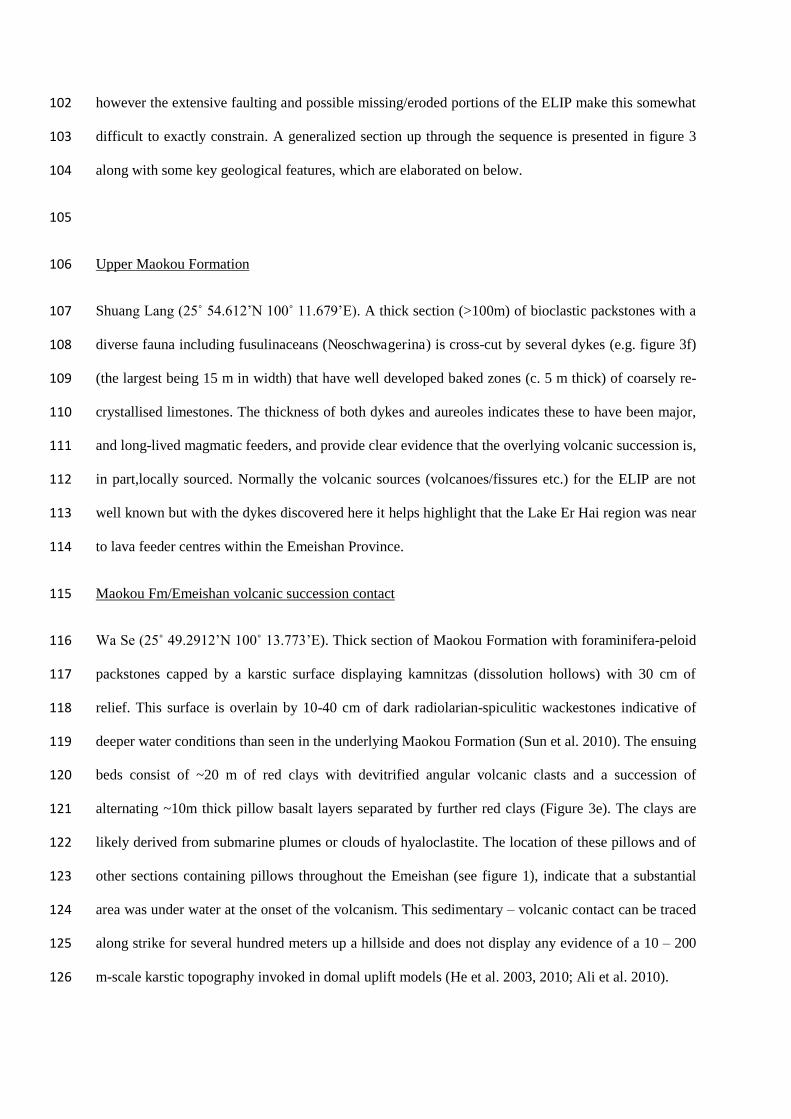
History of emplacement of the Emeishan LIP 91
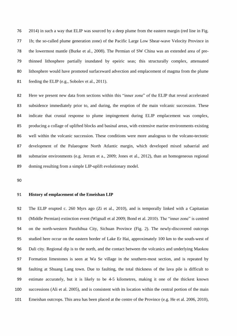
The ELIP erupted c. 260 Myrs ago (Zi et al., 2010), and is temporally linked with a Capitanian 92
(Middle Permian) extinction event (Wignall et al 2009; Bond et al. 2010). The “inner zone” is centred 93
on the north-western Panzhihua City, Sichuan Province (Fig. 2). The newly-discovered outcrops 94
studied here occur on the eastern border of Lake Er Hai, approximately 100 km to the south-west of 95
Dali city. Regional dip is to the north, and the contact between the volcanics and underlying Maokou 96
Formation limestones is seen at Wa Se village in the southern-most section, and is repeated by 97
faulting at Shuang Lang town. Due to faulting, the total thickness of the lava pile is difficult to 98
estimate accurately, but it is likely to be 4-5 kilometres, making it one of the thickest known 99
successions (Ali et al. 2005), and is consistent with its location within the central portion of the main 100
Emeishan outcrops. This area has been placed at the centre of the Province (e.g. He et al. 2006, 2010), 101
however the extensive faulting and possible missing/eroded portions of the ELIP make this somewhat 102
difficult to exactly constrain. A generalized section up through the sequence is presented in figure 3 103
along with some key geological features, which are elaborated on below. 104
105
Upper Maokou Formation 106
Shuang Lang (25˚ 54.612’N 100˚ 11.679’E). A thick section (>100m) of bioclastic packstones with a 107
diverse fauna including fusulinaceans (Neoschwagerina) is cross-cut by several dykes (e.g. figure 3f) 108
(the largest being 15 m in width) that have well developed baked zones (c. 5 m thick) of coarsely re-109
crystallised limestones. The thickness of both dykes and aureoles indicates these to have been major, 110
and long-lived magmatic feeders, and provide clear evidence that the overlying volcanic succession is, 111
in part,locally sourced. Normally the volcanic sources (volcanoes/fissures etc.) for the ELIP are not 112
well known but with the dykes discovered here it helps highlight that the Lake Er Hai region was near 113
to lava feeder centres within the Emeishan Province. 114
Maokou Fm/Emeishan volcanic succession contact 115
Wa Se (25˚ 49.2912’N 100˚ 13.773’E). Thick section of Maokou Formation with foraminifera-peloid 116
packstones capped by a karstic surface displaying kamnitzas (dissolution hollows) with 30 cm of 117
relief. This surface is overlain by 10-40 cm of dark radiolarian-spiculitic wackestones indicative of 118
deeper water conditions than seen in the underlying Maokou Formation (Sun et al. 2010). The ensuing 119
beds consist of ~20 m of red clays with devitrified angular volcanic clasts and a succession of 120
alternating ~10m thick pillow basalt layers separated by further red clays (Figure 3e). The clays are 121
likely derived from submarine plumes or clouds of hyaloclastite. The location of these pillows and of 122
other sections containing pillows throughout the Emeishan (see figure 1), indicate that a substantial 123
area was under water at the onset of the volcanism. This sedimentary – volcanic contact can be traced 124
along strike for several hundred meters up a hillside and does not display any evidence of a 10 – 200 125
m-scale karstic topography invoked in domal uplift models (He et al. 2003, 2010; Ali et al. 2010). 126
Mid Emeishan succession 127
Haichaohe (25˚ 56.265’N 100˚ 10.524’E). Quarry showing 20 m thick succession of breccia 128
composed of Maokou limestone clasts, occasionally showing weak alignment, set in a matrix of 129
siliceous, spiculitic mudstone and interbedded with thin beds of lapilli tuff. Clasts show intense 130
recrystallization and are < 1 m in size, except for a large block of limestone in the centre of the quarry 131
section which is 10 m thick and >30 m wide (figure 3b). Conodont samples from this block yielded 132
late forms of Jinogondolella errata indicating a basal Capitanian early J. postserrata zonal age 133
(Wardlaw and Nestell, 2010). 134
Jiang Wei South (25˚ 56.607’N 100˚ 10.096’E). A 55 m thick road cut section showing, in ascending 135
order, coarse basaltic agglomerate, meter-bedded coarse lapilli tuffs, silt grade tuffs and basaltic 136
conglomerate containing sub-rounded to sub-angular clasts set in a fine grained glassy (now de-137
vitrified) hyaloclastic matrix (e.g. figure 3c-d). The attributes of the last bed suggest some 138
sedimentary reworking but in the lower beds clasts are angular, some with ‘jig-saw fit’ textures 139
revealing in-situ fracturing and/or cooling and lack of subsequent transport. These are interpreted to 140
be mafic volcaniclastic deposits; a common feature in the Emeishan succession (Ukstins Peate and 141
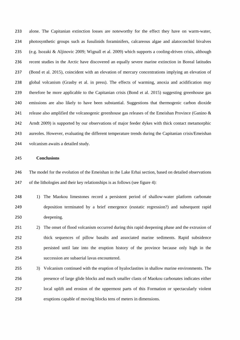
Bryan 2008). Within the volcaniclastic successions, marine fauna are found (e.g. figure 4), which 142
provide unequivocal evidence for eruption in a marine setting with the central part of the Emeishan 143
province. 144
Upper Emeishan succession 145
Jiang Wei (25˚ 57.818’N 100˚ 08.518’E). Basaltic lava flows dominate exposures around Jiang Wei 146
town; these are subaerial sheet flows with well-preserved flow fronts and inflated cores (e.g. figure 147
3a). Several isolated outcrops of limestone c. 50m thick are embedded in this basaltic landscape: one 148
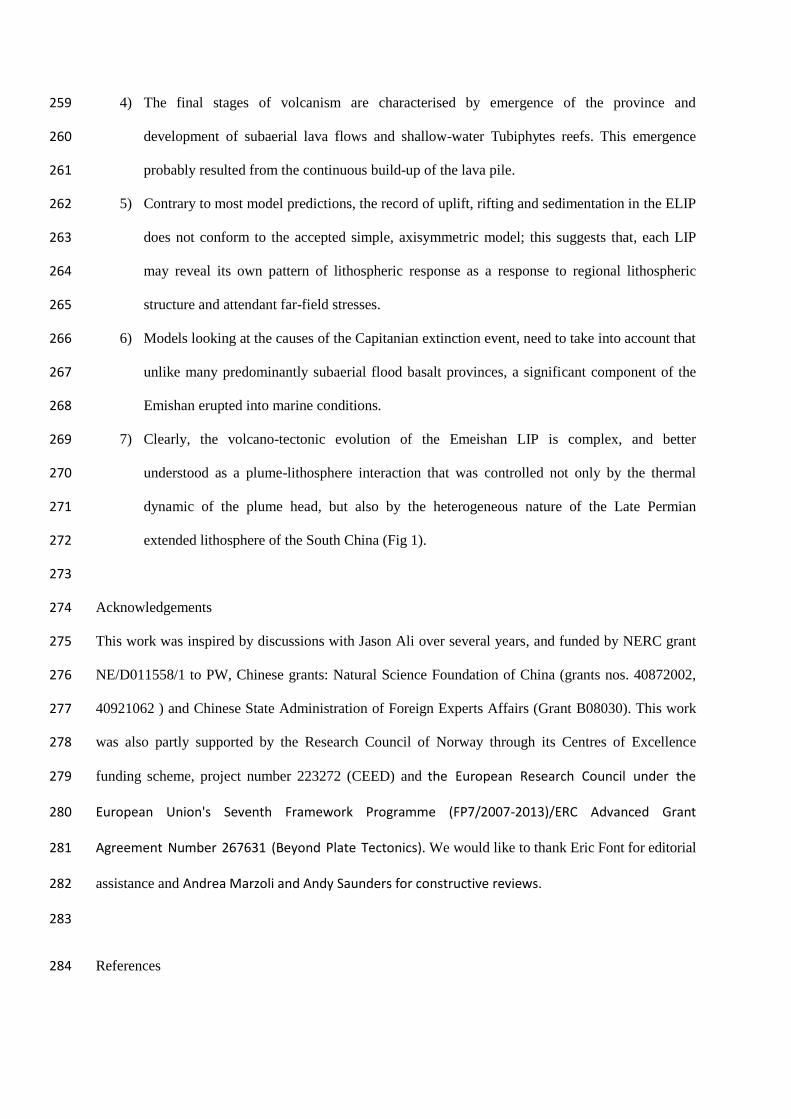
quarry face example reveals a massive Tubiphytes-calcisponge reef, the top surface of which shows a 149
highly irregular topography that records either the original reef surface or localised karstification. 150
Impressively, the overlying lava flow infills this topography and irregular masses of lava occur as 151
“cave fills” up to 8 m below the top contact (figure 5). 152
153
154
Discussion 155
Our field observations demonstrate that the exposed stratigraphy in the central part of the Emeishan is 156
clearly predominantly of marine origin. This marine palaeoenvironment clearly existed well beyond 157
the onset of flood volcanism in the region, and highlights a complex story of the evolution of the ELIP 158
with implication for both uplift and for the associated biological crisis discussed below. 159
(i) Implications for uplift 160
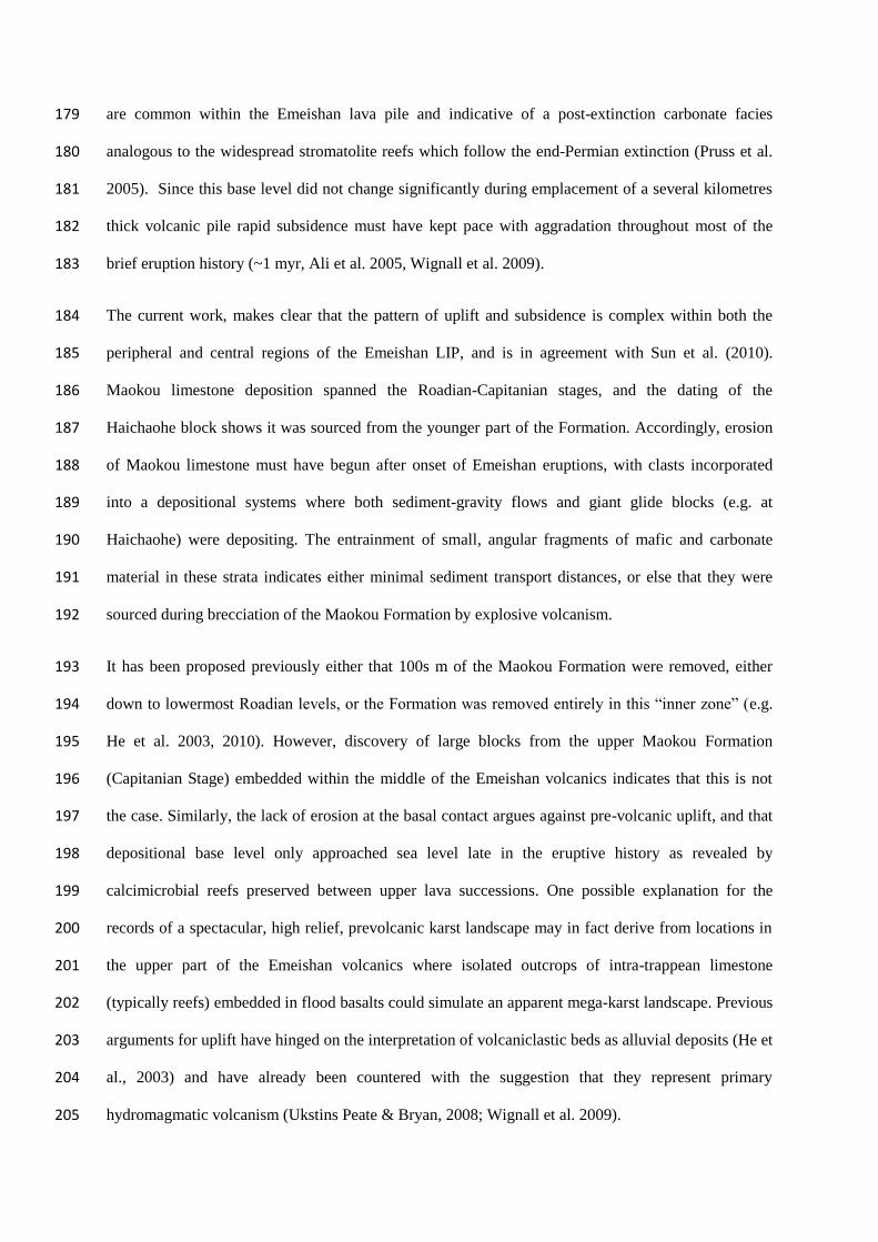
The Lake Erhai sections reveal that much of the volcanic activity near the centre of the province 161
began in submarine environments, and followed a deepening event in the latest phase of the Maokou 162
Formation. The volcanic facies distributed along the Lake Erhai section are depicted in figure 6. In 163
this regard, the region is geologically similar to those developed toward the periphery where platform 164
collapse and deepening is also observed to have preceded eruption (e.g. Wignall et al. 2009; Sun et al. 165
2010). It also supports the recent observations of thick hydrovolcanic units within other newly 166
reported ‘inner zone’ sections, in the Dali area (Zhu et al., 2014). The transition from pillow basalt 167
volcanism through to predominantly hyaloclastites (described as palagonite-rimmed lapilli-tuffs by 168
Zhu et al. 2014) in the mid-Emeishan succession could represent shallowing of the marine 169
environment, possibly with volcaniclastic rocks prograding into the marine environment (e.g. Jerram 170
et al 2009). Indeed the infilling of existing accommodation space within the marine 171
palaeoenvironment of the ‘inner zone’ by the flood basalts would see a swallowing upwards in the 172
cycle (Zhu et al., 2014). Prevalence of diverse pyroclastic activity in all but the latest stages of the 173
eruption history, reveals continuation of shallow marine emplacement and associated 174
phreatomagmatic style eruptions (Ukstins Peate & Bryan, 2008: Zhu et al., 2014). Only in the later 175
stages of the LIP eruptions do sub-aerial flood basalt flows become developed, and even in this part of 176
the lava stratigraphy interbedded Tubiphytes reefs demonstrate a close balance between emplacement 177
and subsidence that kept the growing volcanic edifice at, or close to, sea-level. Such microbial reefs 178
are common within the Emeishan lava pile and indicative of a post-extinction carbonate facies 179
analogous to the widespread stromatolite reefs which follow the end-Permian extinction (Pruss et al. 180
2005). Since this base level did not change significantly during emplacement of a several kilometres 181
thick volcanic pile rapid subsidence must have kept pace with aggradation throughout most of the 182
brief eruption history (~1 myr, Ali et al. 2005, Wignall et al. 2009). 183
The current work, makes clear that the pattern of uplift and subsidence is complex within both the 184
peripheral and central regions of the Emeishan LIP, and is in agreement with Sun et al. (2010). 185
Maokou limestone deposition spanned the Roadian-Capitanian stages, and the dating of the 186
Haichaohe block shows it was sourced from the younger part of the Formation. Accordingly, erosion 187
of Maokou limestone must have begun after onset of Emeishan eruptions, with clasts incorporated 188
into a depositional systems where both sediment-gravity flows and giant glide blocks (e.g. at 189
Haichaohe) were depositing. The entrainment of small, angular fragments of mafic and carbonate 190
material in these strata indicates either minimal sediment transport distances, or else that they were 191
sourced during brecciation of the Maokou Formation by explosive volcanism. 192
It has been proposed previously either that 100s m of the Maokou Formation were removed, either 193
down to lowermost Roadian levels, or the Formation was removed entirely in this “inner zone” (e.g. 194
He et al. 2003, 2010). However, discovery of large blocks from the upper Maokou Formation 195
(Capitanian Stage) embedded within the middle of the Emeishan volcanics indicates that this is not 196
the case. Similarly, the lack of erosion at the basal contact argues against pre-volcanic uplift, and that 197
depositional base level only approached sea level late in the eruptive history as revealed by 198
calcimicrobial reefs preserved between upper lava successions. One possible explanation for the 199
records of a spectacular, high relief, prevolcanic karst landscape may in fact derive from locations in 200
the upper part of the Emeishan volcanics where isolated outcrops of intra-trappean limestone 201
(typically reefs) embedded in flood basalts could simulate an apparent mega-karst landscape. Previous 202
arguments for uplift have hinged on the interpretation of volcaniclastic beds as alluvial deposits (He et 203
al., 2003) and have already been countered with the suggestion that they represent primary 204
hydromagmatic volcanism (Ukstins Peate & Bryan, 2008; Wignall et al. 2009). 205
Mantle plume updoming models predict that locations in the centre of the province, such as those 206
studied here, should have experienced deep erosion. However, a simple plume head model is 207
inadequate at explaining all of the observed sedimentary and palaeontological evidence. LIPs can 208
often contain volcaniclastic deposits at the onset of flood volcanism dependent on the 209
palaeoenvironments at eruption (e.g. Ross et al; 2003), their existence and importance is often 210
underestimated due to poor exposure or overlooked. It is known from examples elsewhere, (e.g. North 211
Atlantic Igneous Province; Wrangellia, Canada), that rapid, transient elevation changes result in 212
complex patterns of erosion and sedimentation both prior to, and during flood volcanism, (e.g., 213
Saunders et al., 2007; Greene et al., 2008; Jones et al., 2010). This is especially the case in regions of 214
heterogeneous lithosphere because plume – lithosphere interactions are conditioned not only by the 215
dynamics of the rising plume head (Sleep 1997), but also by the interaction of the plume with 216
rheology and structure of the overlying lithosphere, and the far-field stresses affecting that lithosphere 217
(e.g. Burov and Guillou-Frottier, 2005). In effect, plume—generated surface uplift can become 218
significantly modified resulting in affected regions experiencing crustal dilation and/or contraction 219
(Burov and Gerya, 2014). In such cases, pulses of uplift and subsidence of several hundred metres can 220
produce a series of narrow basins (Burov et al., 2007, 2014), with this system of highs and lows 221
evolving into an intra-basin topography with 10s – 100s km wavelengths and attendant patterns of 222
erosion and deposition. The complex tectonic environment at the time of the Emeishan flood basalts, 223
seems to have resulted in a complex surface response to mantle plume impact, and a significant 224
amount of the volcanic material erupted into the sea. This pattern of lithospheric response in ELIP is 225
consistent with that predicted in recent models (Burov et al., 2014), and thus provides an important 226
link between predictive theory and observation. 227
(ii) Possible effects of sub-marine eruption on end-Guadalupian environment 228
The onset of volcanism in a submarine setting and the consequent violent phreatomagmatic-style 229
eruptions forming volcaniclastics (Fig. 6) may have exacerbated the cooling effects of volcanism due 230
to the input of volatiles into the stratosphere. Additionally, the input of volcanic material directly into 231
the marine environment would have had significantly different consequences than subaerial eruptions 232
alone. The Capitanian extinction losses are noteworthy for the effect they have on warm-water, 233
photosynthetic groups such as fusulinids foraminifers, calcareous algae and alatoconchid bivalves 234
(e.g. Isozaki & Aljinovic 2009; Wignall et al. 2009) which supports a cooling-driven crisis, although 235
recent studies in the Arctic have discovered an equally severe marine extinction in Boreal latitudes 236
(Bond et al. 2015), coincident with an elevation of mercury concentrations implying an elevation of 237
global volcanism (Grasby et al. in press). The effects of warming, anoxia and acidification may 238
therefore be more applicable to the Capitanian crisis (Bond et al. 2015) suggesting greenhouse gas 239
emissions are also likely to have been substantial. Suggestions that thermogenic carbon dioxide 240
release also amplified the volcanogenic greenhouse gas releases of the Emeishan Province (Ganino & 241
Arndt 2009) is supported by our observations of major feeder dykes with thick contact metamorphic 242
aureoles. However, evaluating the different temperature trends during the Capitanian crisis/Emeishan 243
volcanism awaits a detailed study. 244
Conclusions 245
The model for the evolution of the Emeishan in the Lake Erhai section, based on detailed observations 246
of the lithologies and their key relationships is as follows (see figure 4): 247
1) The Maokou limestones record a persistent period of shallow-water platform carbonate 248
deposition terminated by a brief emergence (eustatic regression?) and subsequent rapid 249
deepening. 250
2) The onset of flood volcanism occurred during this rapid deepening phase and the extrusion of 251
thick sequences of pillow basalts and associated marine sediments. Rapid subsidence 252
persisted until late into the eruption history of the province because only high in the 253
succession are subaerial lavas encountered. 254
3) Volcanism continued with the eruption of hyaloclastites in shallow marine environments. The 255
presence of large glide blocks and much smaller clasts of Maokou carbonates indicates either 256
local uplift and erosion of the uppermost parts of this Formation or spectacularly violent 257
eruptions capable of moving blocks tens of meters in dimensions. 258
4) The final stages of volcanism are characterised by emergence of the province and 259
development of subaerial lava flows and shallow-water Tubiphytes reefs. This emergence 260
probably resulted from the continuous build-up of the lava pile. 261
5) Contrary to most model predictions, the record of uplift, rifting and sedimentation in the ELIP 262
does not conform to the accepted simple, axisymmetric model; this suggests that, each LIP 263
may reveal its own pattern of lithospheric response as a response to regional lithospheric 264
structure and attendant far-field stresses. 265
6) Models looking at the causes of the Capitanian extinction event, need to take into account that 266
unlike many predominantly subaerial flood basalt provinces, a significant component of the 267
Emishan erupted into marine conditions. 268
7) Clearly, the volcano-tectonic evolution of the Emeishan LIP is complex, and better 269
understood as a plume-lithosphere interaction that was controlled not only by the thermal 270
dynamic of the plume head, but also by the heterogeneous nature of the Late Permian 271
extended lithosphere of the South China (Fig 1). 272
273
Acknowledgements 274
This work was inspired by discussions with Jason Ali over several years, and funded by NERC grant 275
NE/D011558/1 to PW, Chinese grants: Natural Science Foundation of China (grants nos. 40872002, 276
40921062 ) and Chinese State Administration of Foreign Experts Affairs (Grant B08030). This work 277
was also partly supported by the Research Council of Norway through its Centres of Excellence 278
funding scheme, project number 223272 (CEED) and the European Research Council under the 279
European Union's Seventh Framework Programme (FP7/2007-2013)/ERC Advanced Grant 280
Agreement Number 267631 (Beyond Plate Tectonics). We would like to thank Eric Font for editorial 281
assistance and Andrea Marzoli and Andy Saunders for constructive reviews. 282
283
References 284
Ali, J. R., Thompson, G. M., Zhou M., Song X., 2005. Emeishan large igneous province, SW China. 285
Lithos 79, 475-489. 286
Ali, J.R., Fitton, J.G., Herzberg, C., 2010. Emeishan large igneous province (SW China) and the 287
mantle-plume up-doming hypothesis. J. Geol. Soc. Lond. 167, 953-959. 288
Bond, D.P.G., Hilton, J., Wignall, P.B., Ali, J.R., Stevens, L.G., Sun, Y-D., Lai X-L., 2010. The 289
Middle Permian (Capitanian) mass extinction on land and in the oceans. Earth-Sci. Rev. 109, 290
100-116. 291
Bond, D. P. G.; Wignall, P. B., Joachimski, M.M., Sun, Y.-D., Savov, I., Grasby, S.E., Beauchamp, 292
B., Blomeier, D.P.G., 2015. An abrupt extinction in the Middle Permian (Capitanian) of the 293
Boreal Realm (Spitsbergen) and its link to anoxia and acidification. Bull. Geol. Soc. Amer. doi: 294
10.1130/B31216.1 295
Bond, D. P. G.; Wignall, P. B. Wang, W. Izon, G. Jiang, H.-S. Lai, X.-L. Sun, Y.-D. Newton, R. J. 296
Shao, L.-Y. Védrine, S., Cope, H., 2010. The mid-Capitanian (Middle Permian) mass extinction 297
and carbon isotope record of South China. Palaeogeogr., Palaeoclimatol., Palaeoecol., 292, 282–298
294. 299
Boucot, A.J., Xu, C., Scotese, R., 2013. Phanerozoic paleoclimate: An atlas of lithologic indicators of 300
climate. SEMP Concepts in Sedimentology and Paleontology No. 11, Tulsa, Oklahoma, 478 pp. 301
Bryan, S.E., Ernst, R.E., 2008, Revised definition of large igneous provinces (LIPs): Earth- Sci. Rev. 302
v. 86, p. 175–202. 303
Burke, K., Steinberger, B., Torsvik, T. H., Smethurst, M. A., 2008. Plume generation zones at the 304
margins of large low shear velocity provinces on the core–mantle boundary. Earth Planet. Sci. 305
Lett. 265, 49–60. 306
Burov, E., Guillou-Frottier, L., 2005. The plume head-continental lithosphere interaction using a 307
tectonically realistic formulation for the lithosphere. Geophys. J. Int. 161, 469-490. 308
Burov, E., Guillou-Frottier, L., d’Acremont, E., Le Pourhiet, L., Cloetingh, S., 2007. Plume head-309
continental lithosphere interactions near continental plate boundaries. Tectonophysics 434, 15-310
38. 311
Burov, E., Gurya, T., 2014. Asymmetric three-dimensional topography over mantle plumes. Nature 312
513, 85-89. 313
Cocks, L.R.M., Torsvik, T.H., 2013. The dynamic evolution of the Palaeozoic geography of eastern 314
Asia. Earth-Sci, Rev. 117, 40-79. 315
Courtillot, V.E., Renne, P.R., 2003. On the ages of flood basalt events: Comp. Rend. Geosci. 335, 316
113–140. 317
Domeier, M., Torsvik, T.H., 2014. Plate kinematics of the Late Paleozoic. Geosci. Frontiers 5, 303-318
350. 319
Ganino, C., Arndt, N.T. 2009. Climate change caused by degassing of sediments during emplacement 320
of large igneous provinces. Geology 37, 323-326. 321
Grasby, S.E., Beauchamp, B., Bond, D.P.G., Wignall, P.B., Sanei, H., in press. Mercury deposition in 322
association with three Permian extinction events in NW Pangea. Geol. Mag. 323
Greene, A.R., Soates, J.S., Weis, D., 2008. Wrangellia flood basalts in Alaska: A record of plume-324
lithosphere interaction in a Late Triassic oceanic plateau. Geochem. Geophy. Geosyst. 9(12). 325
DOI:10.1029/2008GC002092 326
He B., Xu Y., Chung S.L., Xiao L., Wang Y., 2003. Sedimentary evidence for a rapid, kilometer-scale 327
crustal doming prior to the eruption of the Emeishan flood basalts. Earth Planet. Sci. Lett. 213, 328
391-405. 329
He B., Xu Y., Wang Y., Luo Z., 2006. Sedimentation and lithofacies paleogeography in SW China 330
before and after the Emeishan flood volcanism: New insights into surface response to mantle 331
plume activity. J. Geol. 114, 117-132. 332
He B., Xu Y., Campbell, I., 2009. Pre-eruptive uplift in the Emeishan? Nature Geoscience 2, 530-531. 333
He B., Xu Y., Guan J.-P., Tong, Y-T., 2010. Paleokarst on top of the Maokou Formation: further 334
evidence for domal crustal uplift prior to the Emeishan flood volcanism. Lithos 119, 1-9 335
Isozaki, Y., Aljinovic, D., 2009. End-Guadalupian extinction of the Permian gigantic bivalve 336
Alatoconchidae: end of gigantism in tropical seas by cooling. Palaeogeogr. Palaeoclimatol. 337
Palaeoecol. 284, 11-21. 338
Jerram, D. A., Widdowson, M., 2005. The anatomy of Continental Flood Basalt Provinces: geological 339
constraints on the processes and products of flood volcanism. Lithos 79, 385-405. 340
Jerram, D. A., Single, R.T, Hobbs, R.W., Nelson, C.E., 2009.Understanding the offshore flood basalt 341
sequence using onshore volcanic facies analogues: an example from the Faroe–Shetland basin 342
Geol. Mag. 146,. 353–367. 343
Jones, S.M., Lovell, B., Crosby, A.G., 2012. Comparison of modern and geological observations of 344
dynamic support from mantle convection. J. Geol. Soc. Lond. 169, 745-758. 345
Pruss, S.B., Corsetti, F.A., Bottjer, D.J., 2005. The unusual sedimentary rock record of the Early 346
Triassic: A case study from the southwestern United States. Palaeogeogr. Palaeoclimatol. 347
Palaeoecol. 222, 33-52. 348
Richards, M.A., Duncan, R.A., Courtillot, V.E., 1989. Flood Basalts and Hot-Spot Tracks: Plume 349
Heads and Tails. Science, 246, 103-107. 350
Ross, P.-S., Ukstins Peate, I., Mcclintock, M.K., Xu, Y.G., Skilling, I.P., White, J.D.L., Houghton, 351
B.F., 2003. Mafic volcaniclastic deposits in flood basalt provinces: a review. J. Volcan. 352
Geotherm. Res. 145, 281-314. 353
Saunders, A. D., Jones, S. M., Morgan, L. A., Pierce, K. L., Widdowson, M., Xu Y.-G., 2007. 354
Regional uplift associated with continental large igneous provinces: The roles of mantle plumes 355
and the lithosphere. Chem. Geol. 241, 282–318, doi:10.1016/j.chemgeo.2007.01.017 356
Shao, L., Zhang, P., Ren, D., Lei, J., 1998. Late Permian coal-bearing carbonate successions in 357
southern China: coal accumulation on carbonate platforms. Intern. J. Coal Geol. 37, 235-256. 358
Sleep, N.H., 1997. Lateral flow and ponding of starting plume material. J. Geophys. Res. 102, 10001-359
10012. 360
Sobolev, S.V., Sobolev, A.V., Kuzmin, D.V., Krivolutskaya, N.A., Petrunin, A.G., Arndt, N.T., 361
Radko, V.A., Vasiliev, Y.R., 2011. Linking mantle plumes, large igneous provinces and 362
environmental catastrophes. Nature 477, 312-316. 363
Sun Y-D., Lai X-L., Wignall, P.B., Widdowson, M., Ali, J.R., Jiang H-S., Wang W., Yan C-B., Bond, 364
D.P.G., Védrine, S., 2010. Dating the onset and nature of the Middle Permian Emeishan large 365
igneous province eruptions in SW China using conodont biostratigraphy and its bearing on 366
mantle plume uplift models: Lithos, 119, 20-33. 367
Torsvik, T.H., Steinberger, B., Cocks, L.R.M. Burke, K., 2008. Longitude: Linking Earth's ancient 368
surface to its deep interior. Earth Planet. Sci. Lett. 276, 273-283. 369
Torsvik, T.H. Burke, K., Steinberger, B., Webb, S.C. Ashwal, L.D., 2010. Diamonds sourced by 370
plumes from the core mantle boundary. Nature 466, 352-355 371
Torsvik, T.H., Van der Voo, R., Doubrovine, P.V., Burke, K., Steinberger, B., Ashwal, L.D., Trønnes, 372
R., Webb, S.J., Bull, A.L., 2014. Deep mantle structure as a reference frame for movements in 373
and on the Earth. Proc. Nat. Acad. Sci. 111, 24, 8735–8740. 374
Wang, H., Shao, L., Hao, L., Zhang, P., Glasspool, I.J., Wheeley, J.R., Wignall, P.B., Yi, T., Zhang, 375
M., Hilton, J., 2011. Sedimentology and sequence stratigraphy of the Lopingian (Late Permian) 376
coal measures in southwestern China. Int. J. Coal Geol. 85, 168-183. 377
Wardlaw, B.R., Nestell, M.K., 2010. Three Jinogondolella apparatuses from a single bed of the Bell 378
Canyon Formation in the Apache Mountains,West Texas: Micropaleo. 56, 195-212. 379
White, N. & Lovell, J.P.B., 1997. Measuring the pulse of a plume with the sedimentary record. Nature 380
387, 888-891. 381
Wignall, P.B., 2001. Large igneous provinces and mass extinctions. Earth-Sci. Rev. 53, 1–33. 382
Wignall, P.B., Sun Y-D., Bond, D.P.G., Izon, G., Newton, R.J., Védrine, S., Widdowson, M., Ali, 383
J.R., Lai X-L., Jiang H-S., Cope, H, Bottrell, S.H., 2009. Volcanism, mass extinction and 384
carbon isotope fluctuations in the Middle Permian of China. Science 324, 1179-1182. 385
Zhou M-F., Malpas, J., Song, X-Y., Robinson, P.T., Sun, M., Kennedy, A.K. Lesher, C.M., Keays, 386
R.R., 2002. A temporal link between the Emeishan large igneous province (SW China) and the 387
end-Guadalupian mass extinction. Earth Planet. Sci. Lett. 196, 113-122. 388
Zhu, B. Guo, Z., Liu, R., Liu, D., Du, W., 2014. No pre-eruptive uplift in the Emeishan large igneous 389
province: New evidences from its ‘inner zone’, Dali area, Southwest China. J. Volcanol. 390
Geotherm. Res. 269, 57–67. 391

Zi J.-W., Fan, W.-M., Wang, Y-J., Cawood, P.A.,Peng, T.-P. Sun, L.-H., Xu, Z.-Q., 2010. U-Pb 392
geochronology and geochemistry of the Dashibao Basalts in the Songpan-Ganzi Terrane, SW 393
China, with implications for the age of Emeishan volcanism. Amer. J. Sci. 310, 1054-1080. 394
395
396
397
398
399
400
401
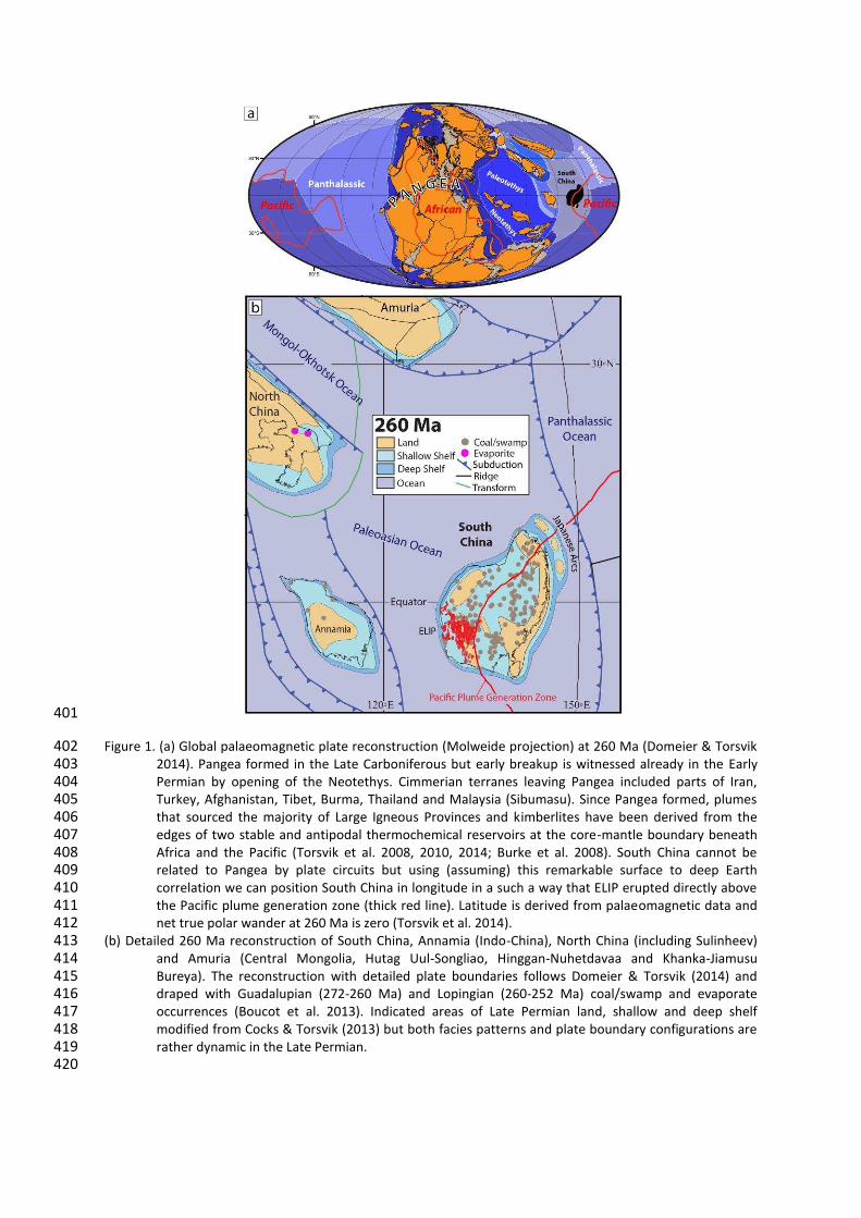
Figure 1. (a) Global palaeomagnetic plate reconstruction (Molweide projection) at 260 Ma (Domeier & Torsvik 402 2014). Pangea formed in the Late Carboniferous but early breakup is witnessed already in the Early 403 Permian by opening of the Neotethys. Cimmerian terranes leaving Pangea included parts of Iran, 404 Turkey, Afghanistan, Tibet, Burma, Thailand and Malaysia (Sibumasu). Since Pangea formed, plumes 405 that sourced the majority of Large Igneous Provinces and kimberlites have been derived from the 406 edges of two stable and antipodal thermochemical reservoirs at the core-mantle boundary beneath 407 Africa and the Pacific (Torsvik et al. 2008, 2010, 2014; Burke et al. 2008). South China cannot be 408 related to Pangea by plate circuits but using (assuming) this remarkable surface to deep Earth 409 correlation we can position South China in longitude in a such a way that ELIP erupted directly above 410 the Pacific plume generation zone (thick red line). Latitude is derived from palaeomagnetic data and 411 net true polar wander at 260 Ma is zero (Torsvik et al. 2014). 412
(b) Detailed 260 Ma reconstruction of South China, Annamia (Indo-China), North China (including Sulinheev) 413 and Amuria (Central Mongolia, Hutag Uul-Songliao, Hinggan-Nuhetdavaa and Khanka-Jiamusu 414 Bureya). The reconstruction with detailed plate boundaries follows Domeier & Torsvik (2014) and 415 draped with Guadalupian (272-260 Ma) and Lopingian (260-252 Ma) coal/swamp and evaporate 416 occurrences (Boucot et al. 2013). Indicated areas of Late Permian land, shallow and deep shelf 417 modified from Cocks & Torsvik (2013) but both facies patterns and plate boundary configurations are 418 rather dynamic in the Late Permian. 419
420
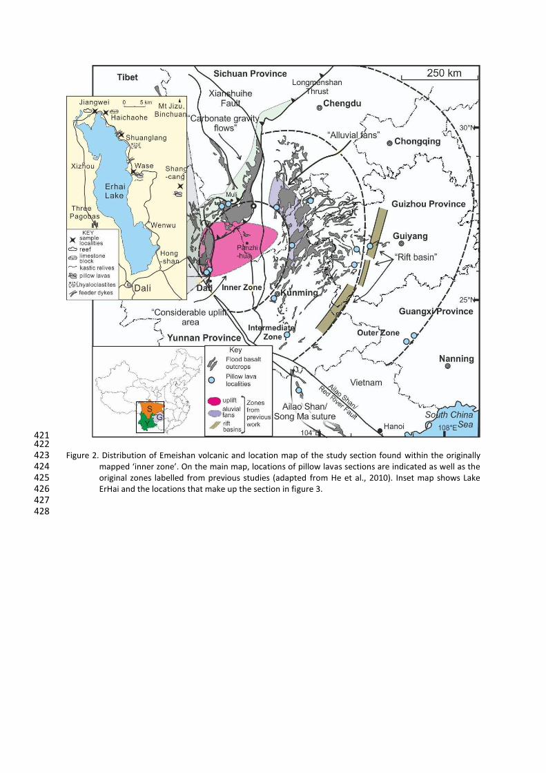
421 422 Figure 2. Distribution of Emeishan volcanic and location map of the study section found within the originally 423
マ;ヮヮWS けキミミWヴ ┣ラミWげく Oミ デエW マ;キミ マ;ヮが ノラI;デキラミゲ ラa ヮキノノラ┘ ノ;┗as sections are indicated as well as the 424 original zones labelled from previous studies (adapted from He et al., 2010). Inset map shows Lake 425 ErHai and the locations that make up the section in figure 3. 426
427 428
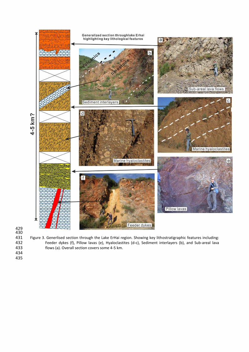
429 430 Figure 3. Generlised section through the Lake ErHai region. Showing key lithostratigraphic features including: 431
Feeder dykes (f), Pillow lavas (e), Hyaloclastites (d-c), Sediment interlayers (b), and Sub-areal lava 432 flows (a). Overall section covers some 4-5 km. 433
434 435
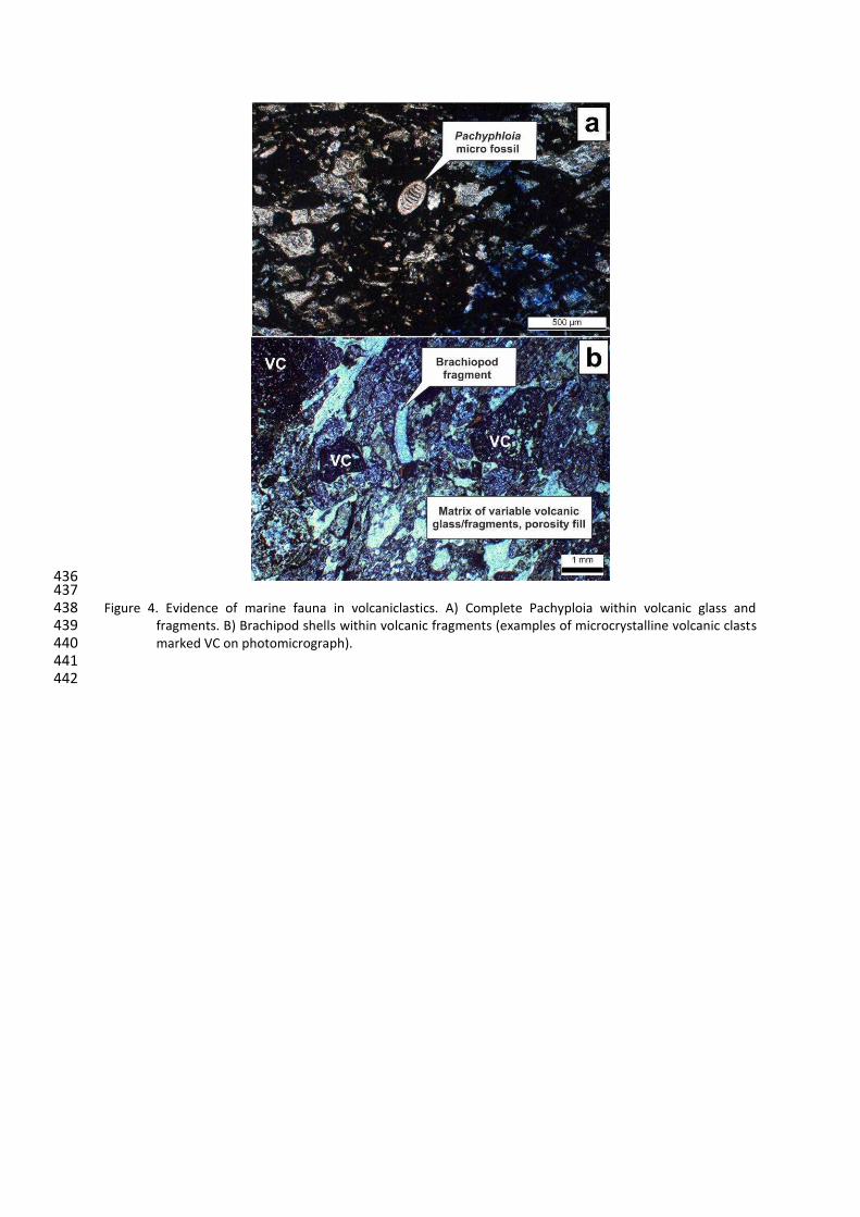
436 437 Figure 4. Evidence of marine fauna in volcaniclastics. A) Complete Pachyploia within volcanic glass and 438
fragments. B) Brachipod shells within volcanic fragments (examples of microcrystalline volcanic clasts 439 marked VC on photomicrograph). 440
441 442
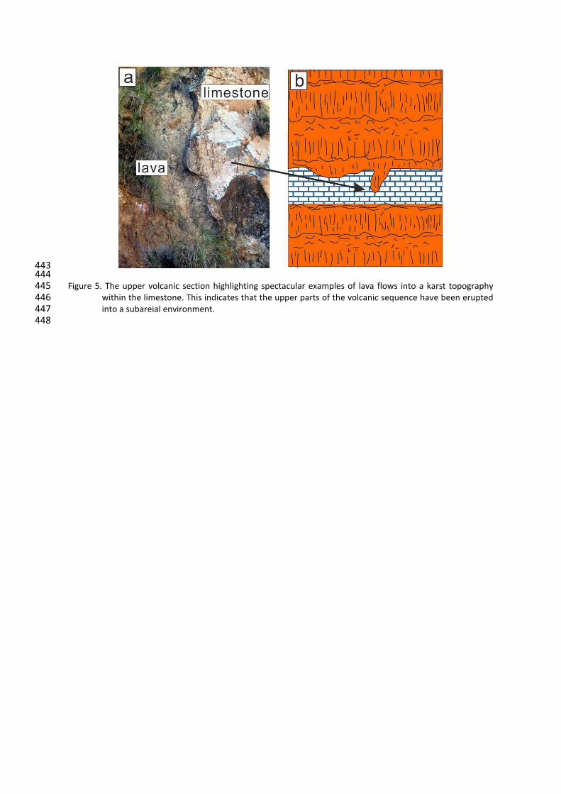
443 444 Figure 5. The upper volcanic section highlighting spectacular examples of lava flows into a karst topography 445
within the limestone. This indicates that the upper parts of the volcanic sequence have been erupted 446 into a subareial environment. 447
448
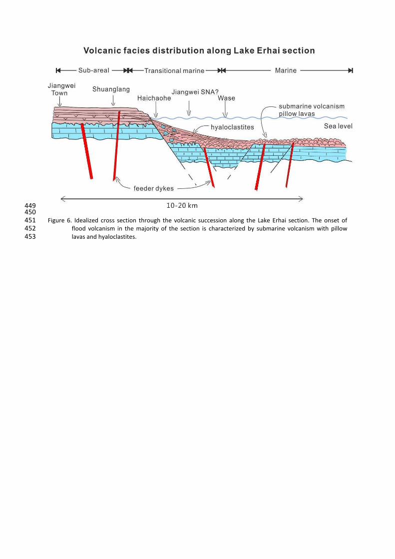
449 450 Figure 6. Idealized cross section through the volcanic succession along the Lake Erhai section. The onset of 451
flood volcanism in the majority of the section is characterized by submarine volcanism with pillow 452
lavas and hyaloclastites. 453