Embed Size (px)
Citation preview
SUBSECTION 8.16
Paleontological Resources

8.16 Paleontological Resources 8.16.1 Introduction Paleontological resources are fossils, the remains of prehistoric plants and animals, that are important scientific and educational resources because of their use in (1) documenting the presence and evolutionary history of particular groups of extinct and extant organisms, (2) reconstructing the environments in which these organisms lived, and (3) determining the relative ages of the strata in which they occur and the geologic events that resulted in the deposition of the sediments that formed these strata. This subsection summarizes the paleontological resources and the potential impacts on paleontological resources that may result from construction of the San Francisco Electric Reliability Project (SFERP). Prior paleontological resources assessments by Fisk (2004) and Spaulding (2000) are the primary basis for this current assessment. In addition, the current literature was consulted primarily to gain a better understanding of the subsurface stratigraphy that may occur in the project area.
Potential impacts on paleontological resources can be divided into construction-related impacts and impacts related to plant operation. No impacts on paleontological resources are expected to occur from the operation of the SFERP. However, construction-related impacts to paleontological resources could occur as a result of numerous ground disturbing or earth-moving activities during construction. Ground-disturbing and earth-moving activities deeper than the artificial fill at the SFERP site could disturb potentially fossiliferous sediments of the Franciscan Complex and Pleistocene sediments, all of which have produced significant fossils elsewhere. However, although each of the native stratigraphic units that could be impacted by construction are potentially fossiliferous and any fossils discovered could be significant and scientifically important, the overall probability of earth moving related to SFERP construction having adverse impacts to nonrenewable paleontological resources is considered to be low. This is based on the extensive presence of artificial fill and its inferred depth in the Islais Creek estuary. Moreover, potential impacts on paleontological resources resulting from SFERP construction can be mitigated to an insignificant level as described herein. Thus, the proposed project would not cause significant unavoidable adverse impacts as defined by CEQA.
The site proposed for construction is located on a parcel between Cesar Chavez Street and 25th Street to the south and north, respectively, and immediately to the west of Maryland Street, in the Potrero District of the City of San Francisco (City) (see Figure 1-2). The project also includes a construction laydown area immediately to the east of the site. There are four laterals leading variable distances offsite. The first is a process water pipeline that extends along Cesar Chavez Street west to Mississippi Street, and then generally south on Mississippi to a pump station at Marin and Mississippi. The total length of the process water line is 0.76 mile. The second lateral is an electrical transmission line that will first extend west along 25th Street to Michigan, then north on Michigan Street to 24th Street where it extends to the west to Illinois Street. From the intersection of Illinois and 24th Streets the transmission line will continue north on Illinois. Two options are being considered for interconnection to the PG&E Potrero Substation: (1) directly from Illinois and (2) from 22nd Street. The total length of the transmission line will be less than 3,000 feet. A natural gas supply line will lead west from the northwest corner of the SFERP site along 25th Street
E022005012SAC/184288/050690028 (SFPUC_008-16.DOC) 8.16-1
SUBSECTION 8.16: PALEONTOLOGICAL RESOURCES
to a point of interconnection at Illinois and 25th, a total distance of approximately 900 feet. A short, potable water line will extend south from the southeast corner of the site to a point of interconnection at Cesar Chavez Street, a distance of approximately 300 feet.
8.16.2 Laws, Ordinances, Regulations, and Standards Paleontological resources are nonrenewable scientific and educational resources and are protected by several federal and state statutes (California Office of Historic Preservation, 1983; see also Marshall, 1976, West, 1991, Fisk and Spencer, 1994, and Gastaldo, 1999), most notably by the 1906 Federal Antiquities Act and other subsequent federal legislation and policies and by the State of California’s environmental regulations (California Environmental Quality Act [CEQA], Section 15064.5). Professional guidelines for the assessment and mitigation of impacts to paleontological resources have been disseminated by the Society of Vertebrate Paleontology (SVP). Design and construction of the proposed SFERP will be conducted in accordance with all laws, ordinances, regulations, and standards (LORS) applicable to paleontological resources. Federal and State LORS directly applicable to paleontological resources are summarized in Table 8.16-1 and discussed briefly below, along with relevant County, City, and SVP guidelines.
TABLE 8.16-1 LORS Applicable to Paleontological Resources
LORS Applicability Reference Project Conformity
Federal Antiquities Act of 1906
Protects paleontological resources on federal lands
Subsection 8.16.2.1
Yes
State CEQA, Appendix G Requires that impacts to paleontological resources be assessed and mitigated on all discretionary projects, public and private
Subsection 8.16.2.2
Yes
California Public Resources Code Chapter 1.7, Section 5097.5 (Stats. 1965, c. 1136, p. 2792)
Defines any unauthorized disturbance or removal of a fossil site or fossil remains on public land as a misdemeanor and specifies that state agencies may undertake surveys, excavations, or other operations as necessary on state lands to preserve or record paleontological resources
Subsection 8.16.2.2
Yes
8.16.2.1 Federal LORS Federal protection for significant paleontological resources would only apply to the SFERP if any construction or other related project impacts occur on federally-owned or federally-managed lands. Federal legislative protection for paleontological resources stems primarily from the Antiquities Act of 1906 (PL 59-209; 16 United States Code 431 et seq.; 34 Stat. 225), which calls for protection of historic landmarks, historic and prehistoric structures, and other objects of historic or scientific interest on federal lands. Since the SFERP site and its linear features do not impact federally-owned or managed land, federal LORS do not apply to this project.
8.16-2 E022005012SAC/184288/050690028 (SFPUC_008-16.DOC)
SUBSECTION 8.16: PALEONTOLOGICAL RESOURCES
8.16.2.2 State LORS The California Energy Commission (CEC) environmental review process under the Warren-Alquist Act is considered functionally equivalent to that of the California Environmental Quality Act (CEQA; Public Resources Code Sections 21000 et seq.). CEQA requires that public agencies and private interests identify the potential environmental consequences of their proposed projects on any object or site of significance to the scientific annals of California (Division I, California Public Resources Code Section 5020.1 [b]). Guidelines for the Implementation of CEQA (Public Resources Code Sections 15000 et seq.) define procedures, types of activities, persons, and public agencies required to comply with CEQA. Appendix G in Section 15023 provides an Environmental Checklist of questions that a lead agency should address if relevant to a project’s environmental impacts. One of the questions to be answered in the Environmental Checklist (Section 15023, Appendix G, Section V, Part c) is the following: “Would the project directly or indirectly destroy a unique paleontological resource or site…?”
Although CEQA does not define what is “a unique paleontological resource or site,” Section 21083.2 defines “unique archaeological resources” as “…any archaeological artifact, object, or site about which it can be clearly demonstrated that, without merely adding to the current body of knowledge, there is a high probability that it meets any of the following criteria:
1. [It] contains information needed to answer important scientific research questions and that there is a demonstrable public interest in that information.
2. It has a special and particular quality such as being the oldest of its type or the best available example of its type.
3. [It] is directly associated with a scientifically recognized important prehistoric or historic event.”
With only slight modification, this definition of “unique archaeological resources” is equally applicable to recognizing “a unique paleontological resource or site.” Additional guidance is provided in CEQA Section 15064.5 (a)(3)(D), which indicates “generally, a resource shall be considered historically significant if it has yielded, or may be likely to yield, information important in prehistory or history.”
Section XVII, Part a, of the CEQA Environmental Checklist asks a second question equally applicable to paleontological resources: “Does the project have the potential to eliminate important examples of the major periods of California history or pre-history?” Fossils are important examples of the major periods of California prehistory. To be in compliance with CEQA, environmental impact assessments, statements, and reports must answer both these questions in the Environmental Checklist. If the answer to either question is yes or possibly, a mitigation and monitoring plan should be designed and implemented to protect significant paleontological resources.
The CEQA lead agency having jurisdiction over a project is responsible to ensure that paleontological resources are protected in compliance with CEQA and other applicable statutes. The lead agency with the responsibility to ensure that fossils are protected during construction of the proposed SFERP is the CEC. California Public Resources Code Section 21081.6, entitled Mitigation Monitoring Compliance and Reporting, requires that the CEQA
E022005012SAC/184288/050690028 (SFPUC_008-16.DOC) 8.16-3
SUBSECTION 8.16: PALEONTOLOGICAL RESOURCES
lead agency demonstrate project compliance with mitigation measures developed during the environmental impact review process.
Other state requirements for paleontological resource management are in California Public Resources Code Chapter 1.7, Section 5097.5 (Stats. 1965, c. 1136, p. 2792), entitled Archaeological, Paleontological, and Historical Sites. This statute defines any unauthorized disturbance or removal of a fossil site or fossil remains on public land as a misdemeanor and specifies that state agencies may undertake surveys, excavations, or other operations as necessary on state lands to preserve or record paleontological resources. This statute would apply to the proposed SFERP since construction or other related project impacts would occur on publicly owned or managed lands.
8.16.2.3 County and City LORS California Planning and Zoning Law requires each county and city jurisdiction to adopt a comprehensive, long-term general plan for its development. The general plan is a policy document designed to give long range guidance to those making decisions affecting the future character of the planning area. It represents the official statement of the community’s physical development as well as its environmental goals. The general plan also acts to clarify and articulate the relationship and intentions of local government to the rights and expectations of the general public, property owners, and prospective investors. Through its general plan, the local jurisdiction can inform these groups of its goals, policies, and development standards; thereby communicating what must be done to meet the objectives of the general plan.
The current general plan for the City and County of San Francisco (CCSF) (2000) contains no specific requirements, regulations, ordinances, conditions, standards, goals, or objectives designed to mitigate the negative impacts of development on paleontological resources. However, the General Plan contains the following general statement in Policy 1.4: “Assure that all new development meets strict environmental quality standards….” In explaining this policy, the General Plan states: “In reviewing all proposed development for probable environmental impact, careful attention should be paid to upholding high environmental quality standards.” In addition, the Environmental Protection section of the Central Waterfront chapter of the general plan states in Objective 7: “Assure that the land resources in San Francisco are used in ways that both respect and preserve the natural values of the land and serve the best interests of all the City’s citizens.” San Francisco general plan Policy 7.1 states, “Features of a…geological…nature are also important criteria [in determining the value of land] as open space. These natural values of land should be respected.” The Preservation Element of the San Francisco general plan presents a comprehensive set of policies for the preservation of San Francisco’s cultural resources and defines cultural resources to “include…objects…which are historically or archaeologically significant, or significant in our…scientific…or cultural annals.” This section of the General Plan establishes as a goal: “Protect Cultural Resources. Preserve significant cultural resources.” Under CEQA, paleontological resources are included as significant cultural resources.
8.16.2.4 Professional Standards To assist in the compliance with applicable laws, the SVP, an international scientific organization of professional vertebrate paleontologists, has disseminated guidelines
8.16-4 E022005012SAC/184288/050690028 (SFPUC_008-16.DOC)
SUBSECTION 8.16: PALEONTOLOGICAL RESOURCES
(SVP, 1995; 1996) that outline acceptable professional practices in the conduct of paleontological resource assessments and surveys; monitoring and mitigation; data and fossil recovery; sampling procedures; and specimen preparation, identification, analysis, and museum curation. The SVP’s guidelines are a commonly used standard against which paleontological monitoring and mitigation programs are evaluated. Briefly, SVP guidelines recommend that each project have literature and museum archival reviews, a field survey, and, if there is a high potential for disturbing significant fossils during project construction, a mitigation plan that includes monitoring by a qualified paleontological monitor, salvage of fossils if encountered, preparation and identification of salvaged fossils, and placement of curated fossil specimens into a permanent retrievable public museum collection (such as the University of California Museum of Paleontology at Berkeley).
8.16.3 Setting 8.16.3.1 Geographic Setting Land use in the vicinity of the proposed SFERP project site is predominantly industrial. To the east there is a dock area, and then the San Francisco Bay east of that. The laydown site is located between this dock and the project site (see Figure 1-2). The area surrounding the SFERP site is completely urbanized, with ever increasing industrial development. The site lies in the northern portion of what was once a relatively large estuary at the mouth of Islais Creek, opening to the Bay to the east.
San Francisco Bay fills a north-northwest-trending structural trough in the central Coast Ranges between the San Andreas Fault to the southwest and the Hayward Fault to the northeast. The City of San Francisco is located in the northern portion of the San Francisco Peninsula, which consists of north-northwest oriented ridges comprising the western portion of the Coast Ranges Physiographic Province (Fenneman, 1931; Jahns, 1954). The Great Valley Physiographic Province is to the east and the Pacific Ocean is to the west.
The general project area is located along the western shore of San Francisco Bay, and the SFERP site lies between the low rolling hills of the San Francisco Peninsula to the west and the Bay to the east. Although the modern Bay shoreline is immediately to the east of the site, the site is entirely on historic fill used to “reclaim” this area from the Islais Creek Estuary, south of the bedrock high that forms Potrero Point. The historic shoreline is approximately 730 meters (2,400 feet) west of the project site (Figure 8.3-2), at about the current position of the I-280 freeway.
In general, the topography of the San Francisco Peninsula consists of bedrock hills surrounding narrow valleys filled with unconsolidated deposits. The project area consists of an essentially level surface with an average elevation of only about 13.5 feet above mean sea level. A few small but prominent rocky hills lie within 2.5 kilometers (1.5 miles) of the SFERP site; Potrero Hill to the northwest, Bernal Heights to the west-southwest, and Hunters Point to the south. These topographic highs and their associated drainages are the source of alluvial sediments that extend (or, in geological terms, “transgress”) into the Bay during periods of low sea level, such as that of the last glacial age. Historic maps show that, in the vicinity of the Islais and Rincon Creek drainages and the project area, the historic topography descended rather steeply to near sea level. The nearly-level ground that now
E022005012SAC/184288/050690028 (SFPUC_008-16.DOC) 8.16-5
SUBSECTION 8.16: PALEONTOLOGICAL RESOURCES
8.16-6 E022005012SAC/184288/050690028 (SFPUC_008-16.DOC)
extends east from the margin of these topographic highs to the project area is artificial and composed entirely of historic fill.
8.16.3.2 Geologic Setting The general geology of the San Francisco area has been described in some detail by Taliaferro (1941, 1951), U. S. Army Corps of Engineers (USACE) (1963), Treasher (1963), Trask and Rolston (1951), Goldman (1967, 1969a), Finlayson et al. (1967), Finlayson et al. (1968), Schlocker (1968, 1974), Helley et al. (1979), Wahrhaftig and Sloan (1989), and Wahrhaftig et al. (1993), among others. The geology in the vicinity of the proposed project facilities has been mapped by numerous workers, including Schlocker (1971, 1:500,000 scale); Helley et al. (1979; 1:125,000 scale), Brabb and Pampeyan (1972; 1:62,500 scale), Lajoie et al. (1974; 1:62,500 scale), and Schlocker (1961, 1974; 1:24,000 scale).
Table 8.16-2 shows that there is a general lack of agreement both on the nomenclature and on the age of different stratigraphic units in the San Francisco Bay Area. The details of the sedimentary geology of the San Francisco Bay and vicinity are not well known due to a number of factors. These include the structural and stratigraphic complexity of the area and a lack of exposures for study. Large portions of the area are covered by water, surficial deposits, artificial fill, and development. One cause of the stratigraphic complexity of the area is the change in sedimentary regimes due to glacio-eustatic changes in sea level. During continental glacial maxima, the shoreline lay at about the current position of the Farallon Islands and non-marine sediments were deposited in the Bay. During warmer interglacial periods, such as the current Holocene, sea level rose to fill the Bay and marine sedimentation dominated. These changes from high to low sea level occur in concert with changes from interglacial to glacial conditions as a substantial fraction of the planet’s water becomes trapped in continental glacials, thus lowering sea level (hence the term “glacio-eustatic”). These sea level changes have occurred with a frequency of approximately one cycle per 100,000 years for at least the last ca. 700,000 years (Morrison, 1991). The Merced Formation, a relatively complete sequence of marine sediments exposed on the west side of the San Francisco Peninsula above Monterey Bay, documents approximately 30 sea-level transgression events between about 1.5 million years ago and 125,000 years ago (Clifton and Leithold, 1991). Each pronounced event would have resulted in an equally pronounced change in sedimentary regime in the Bay.
A somewhat related cause for confusion in the stratigraphic nomenclature is the change in nature of sediments being laid down at any one time as one moves from terrestrial habitats (sands and gravels comprising alluvial, fluvial, and dune deposits), to estuarine environments (muds and fine sands reflecting lagoonal and estuarine habitats), to deeper water conditions (marine muds and clays). Sediments reflecting these conditions are being laid down at any one time, but because of their lateral continuity they can seldom be traced. Therefore, it is not immediately evident whether any given alluvial deposit recovered close to shore is equivalent in age to a marine unit farther out in the Bay.
Finally, as is well-known, the San Francisco Peninsula lies within a tectonically very active area. For example, the Merced Formation outcrops on the west side of the Peninsula represent a sequence of marine sediments more than 1.7 kilometers thick. This entire stack of sediment appears to have been uplifted by tectonic events during the last ca. 125,000 years. The faulting, warping, and displacement of sediments throughout the
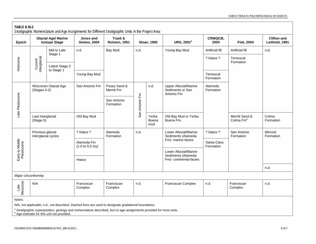
TABLE 8.16-2 Stratigraphic Nomenclature and Age Assignments for Different Stratigraphic Units in the Project Area
Epoch Glacial Age/ Marine
Isotope Stage Jones and
Stokes, 2004 Trask &
Rolston, 1951 Sloan, 1992 URS, 2001aCRWQCB,
2004 Fisk, 2004Clifton and
Leithold, 1991
Artificial fill Artificial fill Mid to Late Stage 1
n.d.
? hiatus ?
Hol
ocen
e
Cur
rent
In
terg
laci
al
Latest Stage 2 to Stage 1
Young Bay Mud
Bay Mud n.d. Young Bay Mud
Temescal Formation
Posey Sand & Merritt Fm
Wisconsin Glacial Age (Stages 4-2)
San Antonio Fm n.d. Upper Alluvial/Marine Sediments or San Antonio Fm
Temescal Formation
n.d.
Late
Ple
isto
cene
Last Interglacial (Stage 5)
Old Bay Mud
San Antonio Formation
San
Ant
onio
Fm
.
Yerba Buena mud
Old Bay Mud or Yerba Buena Fm.
Alameda Formation
Merritt Sand & Colma Fmb
Colma Formation
? hiatus ? ? hiatus ? Lower Alluvial/Marine Sediments (Alameda Fm)- marine facies
Alameda Fm (1.0 to 0.5 my)
Merced Formation
Ear
ly to
Mid
dle
P
leis
toce
ne
Previous glacial-interglacial cycles
Hiatus
Alameda Formation
n.d.
Lower Alluvial/Marine Sediments (Alameda Fm)- continental facies
Santa Clara Formation
San Antonio Formation
n.d.
Major Unconformity
Late
M
esoz
oic
N/A FranciscanComplex
Franciscan Complex
n.d. Franciscan Complex n.d. FranciscanComplex
n.d.
Notes: N/A, not applicable; n.d., not described. Dashed lines are used to designate gradational boundaries.a Stratigraphic superposition, geology and nomenclature described, but no age assignments provided for most units. b Age estimate for this unit not provided.
SUBSECTION 8.16: PALEONTOLOGICAL RESOURCES
184288/050690028 (SFPUC_008-16.DOC) 8.16-7 E022005012SAC/
SUBSECTION 8.16: PALEONTOLOGICAL RESOURCES
San Francisco Bay area, even during relatively recent geological time, contributes to the difficulty of relating various sedimentary units to one another.
Rocks and sediments in the general vicinity of the SFERP site can be divided into two distinct domains. The first and by far the oldest is bedrock composed of Mesozoic age (Jurassic and Cretaceous) low-grade metamorphosed sediments named the Franciscan Complex. The Franciscan Complex forms the bedrock “basement” throughout the area. Sediments resting unconformably on the Franciscan Complex constitute the second major grouping. These are much younger, unconsolidated to poorly consolidated deposits that range in age from Pleistocene to Holocene. These have been variously subdivided and named by geologists (see Table 8.16-2). Formal formation names have been applied to the Pleistocene to Recent sedimentary sequence by some authors (see for instance Lawson, 1914). However, many geologists working in the San Francisco Bay area have used informal designations, such as “old bay mud,” “sand deposits,” and “young bay mud.” As noted above, the geographic extent and limiting geologic ages of both the formal and informal stratigraphic units are frequently uncertain.
8.16.4 Resource Inventory 8.16.4.1 Resource Inventory Methods Recent paleontological resources assessments were completed for the Potrero Power Plant Expansion (Spaulding, 2000) and the original siting of the SFERP (Fisk, 2004), both on Potrero Point approximately 0.5 kilometer (0.3 mile) north of the present project site. Archival record searches (by Spaulding in 1999 and Fisk in 2003) of the University of California Museum of Paleontology (UCMP) in Berkeley, California, were also conducted to gather additional information regarding the occurrence of fossil sites and remains in and near this area. In addition, Rodda and Baghai (1993) provide a relatively recent compendium of vertebrate fossil localities in and near San Francisco. Combined, these studies have thoroughly reviewed the available paleontological data for the study area. Therefore, no additional records search for the current SFERP siting is required to maintain compliance with CEC (2000) and Society of Vertebrate Paleontology (SVP, 1995) guidelines for assessing paleontological resources in areas of potential project impact. In addition, this assessment incorporates a review of the current geological and paleontological literature to further clarify the nature of subsurface stratigraphic units and further evaluate their potential for producing scientifically important paleontological resources.
The SFERP vicinity is thoroughly urbanized with concrete, asphalt, or buildings covering nearly the entire surface area. No rock outcrops or exposures of undisturbed sediments occur on or near the project site. Due to the lack of geological exposures as a consequence of the urbanized nature of the project vicinity, and because the project is sited on artificial fill, no paleontological resources field survey was conducted for this project. Field reconnaissance of the Potrero Point site was done by both Spaulding and Fisk, and Fisk (2004) monitored geotechnical borings at the original SFERP site.
8.16.4.2 Results: Geology and Stratigraphy The SFERP site and vicinity is located within the “Hunters Point Shear Zone” (Schlocker, 1974), a Jurassic-age fault zone that trends northwestward across the San Francisco Peninsula. This fault zone has been repeatedly reactivated and deformed by translational
8.16-8 E022005012SAC/184288/050690028 (SFPUC_008-16.DOC)
SUBSECTION 8.16: PALEONTOLOGICAL RESOURCES
movement along the San Andreas Fault system (Wakabayashi, 1992). Movement along this fault zone over time has resulted in rocks being intensely fractured and sheared. Similar major shear zones are found throughout the Bay area. The Hunters Point Shear Zone is over one mile wide and is floored by a melange of various rock types, but is characterized by the metamorphic rock serpentinite (Schlocker, 1974).
Many potentially fossiliferous deposits in the area have limited local exposure and are discontinuous, and their relationships cannot be determined by tracing their lateral continuity due to that lack of exposure. It is evident from Table 8.16-2 that the statement of Savage (1951) applies more than a half-century later: “Many stratigraphic problems still exist in this area despite the fact that these problems have at times received the attention of competent geologists and paleontologists.” New excavations therefore have the potential to yield important new information, new fossils, or other field evidence, which could add to, confirm, or clarify previous interpretations, as well as provide a more complete and accurate understanding of both the geological and biological history of the area.
Despite the apparent discrepancies, there is some consensus in these studies as well (Table 8.16-2). The major points of consensus, and therefore reliable aspects of the stratigraphic framework of the study area, include the following:
• The Franciscan Complex forms the basement rock throughout this area. It is of Mesozoic age (Jurassic and Cretaceous).
• A pronounced unconformity separates the “Franciscan Complex” from overlying sediments, representing a hiatus of more than 60 million years.
• The oldest sediments resting on the Franciscan Complex recognized thus far in the Bay Area are apparently early Pleistocene in age. These are usually assigned to the “Alameda Formation,” although other nomenclature for these older Pleistocene sediments exists (Table 8.16-2).
• Deposition of fossiliferous sediments in the Bay Area during the Pleistocene was strongly affected by glacio-eustatic changes in sea level as well as by tectonism.
• Sediments representing the last interglacial/glacial/interglacial cycle are well represented in most areas.
• Marine Isotope Stage 5 sediments represent the last interglacial high stand of sea level, and are usually termed the “Old Bay Mud” or “Yerba Buena Formation.” Based on the now well-controlled record of sea level rise and fall in response to global interglacial-glacial cycles, the age of the Old Bay Mud ranges between 130,000 and 75,000 years old (Rancholabrean).
• Low sea level during the last glacial age (Marine Isotope Stages 4 through 2) is often represented by alluvial or fluvial sands attributed to the “San Antonio Formation,” dating from approximately 75,000 to 10,000 years old.
• Global warming and deglaciation at the end of the last Ice Age led to a marine transgression, and the deposition of the sediments usually identified as “Young Bay Mud.” Although these sediments are often assigned a Holocene in age, given the rapid rise in sea level between 15,000 and 10,000 years ago in response to the wasting of the
E022005012SAC/184288/PANAGON (SFPUC_008-16.DOC) 8.16-9
SUBSECTION 8.16: PALEONTOLOGICAL RESOURCES
continental ice sheets, a latest Pleistocene age of lower-most Young Bay Mud in topographic lows would not be unexpected.
• In many areas on the shore of the San Francisco Peninsula, including the present study area, Young Bay Mud is overlain by artificial fill dumped into the Bay in the late 19 and early 20th centuries.
Over the last approximate 700,000 years there have been at least a half-dozen pronounced glacial-interglacial climatic cycles and correspondingly pronounced changes in sea level and sediment deposition. However, only sediments representing the last interglacial-glacial-interglacial cycle, or the last ca. 130,000 years, are widely recognized in the San Francisco Bay area. This suggests that older sediments may be missing or, more likely, that detailed study of the early to middle Pleistocene sediments assigned to the Alameda or San Antonio Formations will eventually reveal a more detailed record of sea level regression and transgression.
The general lack of sediments pre-dating the Pleistocene is also noteworthy. Between the Pleistocene sediments and the Mesozoic Franciscan Complex there are about 60 to 64 million years represented by no sediments whatsoever. The implication is that this region represented a topographic high where erosion rather than sedimentation prevailed. The beginning of tectonic downwarping of the San Francisco Bay trough during the early Pleistocene would account for the initiation of sedimentation represented by the lower-most portion of the Alameda Formation.
8.16.4.2.1 Fossiliferous Sediments. The site proposed for SFERP construction is located entirely on artificial fill. The proposed routes of the process water pipeline and transmission line begin on artificial fill and extend onto areas that were developed on Quaternary alluvium and intertidal deposits. At construction depths, Holocene and then Pleistocene sediments can be expected to be present in the topographic low represented by Islais Creek Estuary. These in turn overlie rocks of the Franciscan Complex. The stratigraphic units with the potential of occurring at the site are individually discussed below, from oldest to youngest.
Mesozoic Rocks of the Franciscan Complex. Bedrock in the vicinity of the SFERP site is composed of altered mafic volcanic rocks (greenstones), sandstone and shale, and serpentinite named the Franciscan Complex (also known as the Franciscan Formation or Franciscan Group). The Franciscan Complex is melange of rock units that were variably deformed and metamorphosed in a subduction zone at the western edge of the North American Plate (Hamilton, 1969; Page, 1981; Wakabayashi, 1992). Franciscan lithologies are predominantly meta-sedimentary rocks with subordinate volcanic rocks that are believed to represent trench fill and volcanic islands, respectively. Although they are uncommon, fossils have been very important in unraveling the ages, depositional environments, and tectonic history of these Franciscan rocks. Major unanswered questions regarding the history of the Franciscan Complex remain (Wakabayashi, 1992).
Within the Franciscan Complex are numerous fault-bounded blocks, each with a distinctive lithology, age, metamorphic grade, and structure, that have been termed tectonostratigraphic terranes (Blake et al., 1982). The San Francisco Peninsula is composed of several coherent tectonostratigraphic terranes separated by major fault zones. The
8.16-10 E022005012SAC/184288/050690028 (SFPUC_008-16.DOC)
SUBSECTION 8.16: PALEONTOLOGICAL RESOURCES
northwest-southeast trending Hunters Point Shear Zone separates the Alcatraz Terrane to the northeast from the Marin Headlands Terrane to the southwest. The Alcatraz Terrane is composed primarily of early Cretaceous-age sandstones and shales, while the Marin Headlands Terrane contains late Cretaceous-age volcanic rocks (metamorphosed to greenstone) and banded radiolarian cherts. The ages of rocks in the Alcatraz and Marin Headland Terranes is based on fossil evidence (Blake et al. 1982; Wakabayashi, 1992). The predominant rock type found within the Hunters Point Shear Zone is serpentinite and greenstone, with occasional tectonic blocks of sandstones and shales of the Alcatraz Terrane.
Lawson (1895) designated San Francisco as the type area for the Franciscan Complex, and originally divided his Franciscan “Series/Group” into five formations. However, after almost 80 years of further study, Schlocker (1974) considered these formations obsolete and suggested that they be abandoned. Schlocker (1974) used the name Franciscan Formation. However, because the stratigraphy of Franciscan-age rocks is not at all simple, many geologists working in the San Francisco area prefer to use the term Franciscan Complex for this complex assemblage of dissimilar rocks.
Ages of Franciscan Complex rocks vary from place to place (Fox, 1983). Based primarily on fossil evidence, rocks in the sequence have been dated as Jurassic, Cretaceous, and (rarely) Early Tertiary. On the San Francisco Peninsula, Franciscan Complex sedimentary facies of the Alcatraz and Marin Headlands Terranes are Cretaceous in age (Schlocker, 1974). Franciscan Complex bedrock occurs below artificial fill at Potrero Point site, and can be expected to lie at greater depth below artificial fill and Quaternary-age sediments at this site.
Early to Middle Pleistocene Sediments. The oldest sediments overlying the Franciscan Complex basement rocks include those assigned to the San Antonio, Alameda, and Santa Clara Formation (Table 8.16-2). They also include the Irvington Gravel and other older alluvial units deformed by tectonic activity and exposed primarily on the east side of the Bay. On the west side of the San Francisco Peninsula they include the primarily marine Merced Formation. These older stratigraphic units are more consolidated and, therefore, have a distinct geomorphic expression in some areas. Lawson (1914) was among the first to note the dissection and terracing that has occurred since their deposition. These deposits were exposed by sea level lowering and tectonic uplift, and downward cutting by streams left many remnants preserved as topographic highs (Robinson, 1956).
Facies relationships among these older sedimentary units can be expected to be complex. In addition to tectonic deformation, any one unit can be expected to have facies that record terrestrial, estuarine, and marine conditions during one time period. Many areas on the San Francisco Peninsula have alternated between being submerged beneath the Bay and being dry land in response to glacially controlled fluctuations of sea level and, perhaps, tectonic uplift. Depending on whether they were deposited during a high or low sea level stand, sediments can reflect environments varying from estuarine and intertidal mud flats, to swamps, streams and alluvial hill slopes of a terrestrial setting.
Early to Middle Pleistocene age sediments are not known to underlie the SFERP site. However, because the current site lies above a topographic low that represents the historic estuary of Islais Creek, they can be expected at some depth.
E022005012SAC/184288/PANAGON (SFPUC_008-16.DOC) 8.16-11
SUBSECTION 8.16: PALEONTOLOGICAL RESOURCES
Late Pleistocene to Holocene Sediments. Most (but not all) studies in the Bay Area recognize a basal unit relating to the last interglacial sea-level high-stand (Marine Isotope Stage 5; known also as the Sangamon) between about 130,000 and 75,000 years ago. In most cases they rest unconformably on older deformed sediments. In depo-centers such as the Bay, the sediments are usually clays and muds and assigned to the Old Bay Mud or Yerba Buena Formation. On topographically elevated surfaces, however, these sediments are normally coarser grained and, despite the fact that they may simply represent facies changes within the same formation, have most often been assigned different names, in particular the Colma Formation and Merritt Sand.
Sea level regression during the subsequent Wisconsin glacial age (ca. 75,000 to 10,000 years ago) witnessed the retreat of the shoreline westward to about the position of the Farallon Islands. The coarser grained terrestrial sediments relating to this period have been identified as the San Antonio Formation by some authors, and the Merritt Sand or Merritt Formation by others (Table 8-16.2). These coarser sediments are in turn capped by the Young Bay Mud, marking the return of marine deposition to the area between 15,000 and 9,000 years ago. Trask and Rolston (1951) named a sand unit below the Young Bay Mud the Merritt Sand. In their study of Quaternary sediments of the Islais Creek Basin (which includes the SFERP site), Radbruch and Schlocker (1958) simply designated equivalent deposits “the sand layer” but did correlate it with the Merritt Sand. On the east side of San Francisco Bay, Radbruch (1957) showed that the marine type Merritt Sand grades into and interfingers with terrestrial alluvial-fan deposits. Schlocker et al. (1958) named possibly equivalent sands exposed on the San Francisco Peninsula the Colma Formation, while clearly stating that at least the marine portion of the Colma was “correlated with the Merritt Sand.”
The Merritt Sand found in the vicinity of the SFERP site is a complex of Pleistocene marine and coastal sediments, including some interbedded gravel, silt, and clay beds. The environment of deposition of Merritt Sand deposits varies greatly over short distances. Depending on whether they were deposited during high or low sea-level, the environment in which they were deposited could vary from offshore marine, estuarine, lagoonal, beach, paludal (swamp), lacustrine (lake), fluvial (stream), flood plain, to dunes (Lawson, 1895; Martin, 1916; Schlocker, 1974). Part of this complexity is no doubt due to the difficulty in discriminating between sand units that may, or may not be related to one another in time and manner of deposition. A sand unit identified as the Merritt Sand by Fisk (2004) was encountered in a geotechnical borehole in the southwestern corner of the Potrero Power Plant and, thus, this unit could be impacted by the placement of concrete piers or support piles in the vicinity of the project site.
Latest Pleistocene and Holocene age younger alluvium in the San Francisco Bay area was named the Temescal Formation by Lawson (1914), who included within this formation alluvial deposits younger than and overlying the Merritt Sand. The principal differences between the younger and older alluvium are stratigraphic position (separated by the Merritt Sand), lithologic components, degree of consolidation, topographic expression, attitude (tilted versus flat-lying), and fossil content. According to Savage (1951), sediments in the San Francisco Bay area containing latest Pleistocene and Holocene fossil faunas can often be distinguished from the older Pleistocene deposits because they are relatively flat-lying, while, in contrast, the older sediments containing early Pleistocene fossil faunas are often slightly tilted. This criterion has also been helpful to others in distinguishing older alluvium
8.16-12 E022005012SAC/184288/050690028 (SFPUC_008-16.DOC)
SUBSECTION 8.16: PALEONTOLOGICAL RESOURCES
from younger alluvium (see Taliaferro, 1951; Hall, 1958; and Helley et al., 1972). According to Taliaferro (1951), the tilting of early Pleistocene sediments is a direct result of Middle Pleistocene orogeny. However, the firm dating of tilted Colma Formation sediments overlying the Middle Pleistocene Merced Formation on the west side of the San Francisco Peninsula (Clifton and Leithold, 1991) indicates that the timing of deformation varies in the region, and in some areas orogenic (or tectonogenic) tilting occurred during the Late Pleistocene era as well. This is consistent with the fact that different faults in the area have different movement rates and different rupture histories.
Like sediments referred to as the “Old Bay Mud” or San Antonio Formation, depending on whether they were deposited during high or low sea level, the depositional environment of Temescal Formation sediments varies from estuarine to swamp to stream.
The age range for sediments referred to the Temescal Formation is late Pleistocene to Holocene. Kvenvolden (1962) reported radiocarbon dates on samples collected 11 to 20 feet below the surface ranging from about 6,000 to 8,000 years before present. Story et al. (1966) reported radiocarbon ages ranged from 2,500 to 7,500 years for samples collected between 2 and 50 feet below the surface. Schlocker (1974) suggests that these sediments were deposited after about 14,000 years ago, when sea level began to rise with the melting of continental ice sheets at the close of the Wisconsin Glacial Age (Table 8-16.2). Geotechnical investigations at the Potrero Power Plant revealed that sediments referable to the Young Bay Mud underlie artificial fill at a depth below about 20 feet in the southwest corner of the initial SFERP site (Fisk, 2004).
8.16.4.2.2 Non-Fossiliferous Sediments. Included in this definition is artificial fill, which could have fragmentary fossil material transported from other sites. Even if such were the case, this material would be out of stratigraphic context and therefore have no scientific value and minimal educational value.
Artificial Fill. Artificial fill is extensive along the margins of San Francisco Bay. The practice of creating land by placing artificial fill on the gently sloping tidal flats along the eastern margin of the San Francisco Peninsula began about the time of the Gold Rush, when San Francisco became a booming center of growth and needed room to expand, particularly along the waterfront. Over time, more than 3 square miles of the most valuable land in San Francisco originated in this way (Schlocker, 1974). For fill, developers used whatever materials were available, including dune sand, alluvium, sediment dredged from the Bay, spoils from excavations, solid rock from quarries, and man-made debris, including foundry slag and garbage. Both the thickness and type of fill vary widely over short distances. It can be expected to decrease in thickness to the west as the historic shoreline of Islais Creek Estuary is approached (Figure 8.3-2). West of about the current position of I-280 the depth of historic fill is expected to be limited.
8.16.4.3 Results: Paleontological Resources An inventory of the paleontological resources in or near the proposed project site is presented below and the paleontological importance of these resources is assessed. To the extent possible, they are related to a particular time period and stratigraphic horizon (Table 8.16-2) based on the results of the literature review and UCMP archival records searches conducted by Spaulding (2000) and Fisk (2004). The results also incorporate
E022005012SAC/184288/PANAGON (SFPUC_008-16.DOC) 8.16-13
SUBSECTION 8.16: PALEONTOLOGICAL RESOURCES
surveys of Quaternary land mammal fossils in the San Francisco Bay area made by Stirton (1939, 1951), Hay (1927), Savage (1951), Lundelius et al. (1983), and Jefferson (1991b); surveys of Quaternary birds, reptiles, and amphibians made by Miller and DeMay (1953) and Jefferson (1991a); and a survey of Pleistocene vertebrate fossil localities by Rodda and Baghai (1993). In addition to UCMP localities, Jefferson (1991a; 1991b) listed Rancholabrean-age vertebrate fossil localities of the California Academy of Science Museum (formerly the Golden Gate Memorial Museum), Academy of Natural Sciences Museum in Philadelphia, Field Museum of Natural History in Chicago, U. S. Geological Survey in Denver, U. S. National Museum in Washington, and Yale Peabody Museum. He listed 10 individual sites in San Francisco County and 16 in adjacent San Mateo County that have yielded Rancholabrean vertebrate fossils (Jefferson, 1991a; 1991b).
No previously recorded fossil sites have been documented within the footprint of the SFERP site, adjacent laydown area, or project laterals (pipelines or transmission line). However, each of the stratigraphic units that could possibly be impacted by construction of the SFERP facilities (excluding artificial fill) has produced significant and scientifically important fossils in the San Francisco area. Several have been documented in the vicinity of the Islais Creek estuary. These known fossils and localities are briefly described below starting with those from the oldest stratigraphic unit. Documented paleontological sites within 4.9 kilometers (3 miles) of the project site are shown in confidential Figure 8.16-1.
8.16.4.3.1 Mesozoic Fossils of the Franciscan Complex. Low-grade metamorphic rocks of the Franciscan Complex have produced highly significant fossils at numerous localities in the past. Schlocker (1974) emphasized the importance of fossils in unraveling the ages, depositional environments, and tectonic history of the Franciscan Complex. Schlocker et al. (1958) reported a Cretaceous ammonite found in shales of the Alcatraz Terrane in northeastern San Francisco. Schlocker (1974) also referred to fossil plant remains in Franciscan rocks, although usually with such terms as “carbonaceous matter,” “lignitic material,” “large carbonaceous particles and layers,” “large abundant paper-thin flakes of coaly material…,” or “carbon having relict plant-cell structures.” Lastly, Schlocker (1974) reported “curved thin shells…that resemble chitinous parts of arthropods and tiny shark’s teeth.” The latter are the only known vertebrate fossils reported from the Franciscan Complex.
Fossils have also been reported in Franciscan rocks by other geologists and paleontologists. As the name implies, radiolarian chert beds in the Franciscan Complex produce microfossils of radiolarian important as biostratigraphic markers. Fossil radiolaria were first described from Franciscan rocks by Hinde (1894) and later by Riedel and Schlocker (1956). Schlocker (1974) wrote: “In some chert beds fossils are so crowded that they touch each other.” Limestone nodules and concretions in Franciscan shales often also contain abundant radiolaria (Schlocker, 1974). Fossil foraminifera have also been reported from Franciscan limestone (Kupper, 1956). Fossil gastropods (snails) and pelecypods (clams) have been reported from a locality on Alcatraz Island and elsewhere by Gabb (1869), Stewart (1930), Anderson (1938), and Ghent (1963). Plant microfossils (pollen and spores) and dinoflagellates have been reported in Franciscan shales (Evitt and Pierce, 1975; Damassa, 1979a, 1979b; Blake et al. 1984), and were instrumental in determining that some rocks included in the Franciscan Complex north of Cape Mendocino are as young as early Tertiary.
8.16-14 E022005012SAC/184288/050690028 (SFPUC_008-16.DOC)
SUBSECTION 8.16: PALEONTOLOGICAL RESOURCES
Locally, the Franciscan Complex contains a melange of various rock types that vary irregularly over short distances (Schlocker, 1974). Likewise the degree of metamorphic alteration varies in intensity from place to place (Schlocker, 1974). Geotechnical boreholes on Potrero Point indicate that the predominant rock type in the Franciscan Complex is serpentinite (Spaulding, 2000). However, on the slopes of Potrero Hill, approximately 0.5 mile west of the SFERP site and still within the Hunters Point Shear Zone, the Franciscan Complex consists of low-grade metamorphosed “sandstone and shale” (Radbruch and Schlocker, 1958) and “sandstone” (Schlocker, 1974). During a field reconnaissance for the original SFERP siting proceeding, an outcrop of non-fossiliferous, arkosic sandstone was discovered on 20th Street between Pennsylvania and Mississippi Streets (Fisk, 2004), approximately 0.8 mile west of the current SFERP site.
8.16.4.3.2. Early and Middle Pleistocene (Irvingtonian) Fossil Records. From his survey of vertebrate faunas from the non-marine Quaternary deposits of the San Francisco Bay region, Savage (1951) concluded that only two faunal divisions could be recognized. He assigned the earlier Pleistocene fauna to what eventually was designated the Irvingtonian North American Land Mammal Age (NALMA) (older than ca. 400,000 years), and the later Pleistocene and Holocene fauna to the Rancholabrean NALMA (younger than ca. 400,000 years). Deformed gravels with interbedded sand and clay in the San Francisco area that have yielded an abundant Early to Middle Pleistocene Irvingtonian fauna (Savage, 1951; Wahrhaftig et al., 1963; Jefferson, 1991a; 1991b) were called the Irvington Gravels by Savage (1951). The Irvington Gravels are distinctly folded and the strata dip as much as 20 to 25 degrees (Savage 1951, Louderback 1951, Hall 1958).
Fossils from sediments referred to the San Antonio, Alameda, Santa Clara, and Merced Formations of most (but not all, see Table 8.16-2) authors are Early to Middle Pleistocene in age, generally coeval with those reported from the Irvington Gravels and equivalents. The terrestrial mammals collected from these units include mammoths, musk oxen, horses, peccaries, camels, deer, elk, pronghorns, ground sloths, saber-tooth cats, dire wolves, coyotes, foxes, gophers, mice, and squirrels (Peabody, 1945; Savage, 1951; Stirton, 1951; Louderback, 1951; Hall, 1958).
When naming the San Antonio Formation, Lawson (1914) noted that this unit contained bones of extinct vertebrates, including ground sloth, bison, mammoth, mastodon, horse, camels, and large carnivores. Savage (1951) questioned the exact stratigraphic position from which some of these specimens were obtained. Helley et al. (1972) also noted that the older alluvial fan deposits locally contain concentrations of continental vertebrate and invertebrate fossils.
Lithologically similar and probably age-equivalent gravels occur elsewhere in the San Francisco Bay area. These gravels have also yielded Irvingtonian-age land mammal fossils (for instance UCMP localities V-6322, V-3602, V-3604, and V-3605) and are probably correlative with the Irvington Gravels.
8.16.4.3.3 Early Late Pleistocene (Last Interglacial) Fossil Records. The oldest sediments of Late Pleistocene age, usually recorded as unconformably overlying Early to Middle Pleistocene units, are those assigned to the Colma Formation, and also occasionally identified as the Merritt Sand and San Antonio Formation. Marine facies have been identified as the Old Bay Mud or Yerba Buena Mud (Table 8.16-2). There is general
E022005012SAC/184288/PANAGON (SFPUC_008-16.DOC) 8.16-15
SUBSECTION 8.16: PALEONTOLOGICAL RESOURCES
consensus that these sediments date to the Last Interglaciation (Marine Isotope Stage 5; 128,000 to 75,000 years) during which, for part of this time, sea level was actually higher than the present by 2 to 3 meters.
The Rancholabrean NALMA of these faunas, as well as those from the younger overlying units (see below), is based on the presence of fossil bison and many mammalian species that were historic inhabitants of the same area. However, it is evident from the literature that the Rancholabrean NALMA, which began 400,000 to 500,000 years ago (Kurten and Anderson, 1980), is frequently considered to be contemporaneous with the Late Pleistocene, which began about 128,000 years ago at the Marine Isotope Stage 6/5e boundary. This, in addition to other factors listed above, has contributed to the difficulty of knowing precisely which sediments may have yielded a particular fauna, and where they may fall chronologically within the rather long time span of the Rancholabrean.
The Colma Formation has produced significant marine and terrestrial fossils in the past. Rodda and Baghai (1993) reported bones and teeth of mammoth and extinct bison from sands and clays unconformably overlying the Franciscan Complex that they refer to the Colma Formation. Fossil diatoms and pollen were also recovered from this site with the former indicating an estuarine environment. A leg bone of a ground sloth (Glossotherium sp.) had been previously recovered from a shallow well in this same vicinity (Winslow, 1876; Stock, 1925; Hay, 1927), which Rodda and Baghai (1993) relate to the same bone bed. A radiocarbon age of 25,380 +/- 1,100 years before present (ibid.) for fossils found at this site would, however, make it too young for the Colma Formation (Stage 5, or 128,000 to 75,000 years old). The standard deviation of the radiocarbon date is large, and it would take only a minute amount of modern carbon to make a sample that is older than the range of radiocarbon dating (>30,000 years for conventional counters), appear to be younger. During excavations for the Broadway Tunnel, a fossil “tree” was discovered and identified by paleobotanist Roland W. Brown as a juniper or red cedar, probably Juniperus californica (Schlocker, 1974). Wood from this tree was radiocarbon dated at greater than 30,000 years before present.
Savage (1951) listed other vertebrate fossil localities in the San Francisco Bay region to which he assigned an “undifferentiated Pleistocene” age. Some of these additional vertebrate fossils may also be referable to the Colma Formation. Schlocker (1974) reported fossil plant remains and a peat layer at the top of his Colma Formation, the latter possibly representing “an old soil that developed in or near local marshes or lakes.” Marine facies of the Colma Formation (including some units identified as the Merritt Sand) have produced marine megafossils, marine and nonmarine diatoms, and sponge spicules (Schlocker, 1974). Fossil mollusk shell fragments were observed in a core from a depth of approximately 30 feet in what Fisk (2004) identified as the Merritt Sand, in a geotechnical bore hole in the southwestern corner of the initial SFERP site.
8.16.4.3.4 Late Pleistocene (Wisconsin Glacial Age) and Holocene (Current Interglacial) Fossil Records. Numerous Late Pleistocene and Holocene fossils have been reported from sediments referred to variously as the Temescal and San Antonio Formations in the San Francisco area, the marine facies of which appear to be represented by the Young Bay Mud (Table 8.16-2). Hay (1927) listed numerous discoveries made between 1873 and 1927. Peabody (1945) added to this list.
8.16-16 E022005012SAC/184288/050690028 (SFPUC_008-16.DOC)
SUBSECTION 8.16: PALEONTOLOGICAL RESOURCES
Sediments assigned to the Temescal Formation by Fisk (2004; Table 8.16-2) have yielded fossil remains of petrified wood, marine mollusks and mammals, bony fishes, amphibians, reptiles, birds, and a diversity of extinct land mammals, including ground sloths, mammoth, mastodon, deer, horse, camel, and bison (Hay, 1927; Stock, 1925; Miller and Peabody, 1941; Savage, 1951; Jefferson, 1991b; UCMP records). Fossils recovered from Wisconsin and Holocene-age sediments at sites in the area around San Francisco Bay also include microfossils useful in paleoenvironmental reconstructions (radiolaria, foraminifera, sponge spicules, coccoliths, diatoms, dinoflagellates, pollen, and spores) (Atwater et al., 1977; McGann et al., n.d.; Sloan 1992). Schlocker (1974) has also reported fossil plant remains from sediments he referred to as “Bay mud and clay.” Bonilla (1971) reported fossil shells and plant remains from “Bay Mud.” Where applied, the use of microfossils has promise in clarifying stratigraphic and facies relationships of these various sedimentary units.
A number of fossil sites are reported as having been discovered during excavations associated with construction projects, including the Bay Bridge, Bay Shore Southern Pacific Tunnel, Twin Peaks Tunnel, construction of an office building on Pacific Street, and construction of the Southeast Sewage Treatment Plant (now known as the Southeast Water Pollution Control Plant) (Radbruch and Schlocker, 1958; Jefferson, 1991a, 1991b, Rodda and Baghai, 1993; UCMP records).
Remains of land mammals have been found at a number of localities in younger alluvium (Louderback, 1951; Savage, 1951; Stirton, 1951; Jefferson, 1991b). The most common vertebrate fossils reported from Rancholabrean-age alluvial sediments in the San Francisco Bay area are the remains of extinct mammoth, bison, and horse.
UCMP vertebrate fossil locality V-65243, known as the Twin Peaks Tunnel site, located approximately 4.7 kilometers (2.9 miles) northwest of the SFERP site, produced Rancholabrean-age fossils. In the vicinity of the Islais Creek Channel about 0.4 kilometers (1,200 feet) south of the SFERP site, UCMP locality V-3410 yielded a sparse Rancholabrean-age fossil fauna. Radbruch and Schlocker (1958) also reported the recovery of fossils from borings in the Islais Creek area in sediment identified as Old Bay Mud (Table 8.16-2). Radbruch and Schlocker (1958) also reported the discovery of fossil plants and mollusk fossils in an excavation at the Southeast Sewage Treatment Plant (now known as the Southeast Water Pollution Control Plant). Two localities in South San Francisco (UCMP localities V-6203 and V-6319) have also produced Rancholabrean faunas, including bison and elk or moose. During construction of the San Francisco-Oakland Bay Bridge, part of a jaw of a bison with several teeth, bones and teeth of horses, and a mammoth tooth were collected from sediments considered to be late Pleistocene (Louderback 1951, Savage 1951). These localities are now referred to as UCMP localities V-34011 and V-69186. Abundant fossil mollusk shells were observed in cores of Young Bay Mud from depths of approximately 20 and 25 feet in a geotechnical borehole in the southwestern corner of the initial SFERP site.
8.16.4.3.5 Artificial Fill. No fossils have been recorded from artificial fill in the San Francisco Bay area. However, since artificial fill includes sediments from the older formations discussed above, it is possible that such fossils exist. Such fossils would have been transported from their original source and would be lacking stratigraphic context and provenance. An unconsolidated sand containing mollusk shell fragments was observed in cores from depths of approximately 10 and 15 feet in a geotechnical borehole in the south-central portion of the
E022005012SAC/184288/PANAGON (SFPUC_008-16.DOC) 8.16-17
SUBSECTION 8.16: PALEONTOLOGICAL RESOURCES
initial SFERP site. This sand was underlain by deposits of foundry slag, charcoal, and ash, clearly demonstrating that the shell-bearing sand is artificial fill.
8.16.5 Impacts The potential environmental impacts on paleontological resources from construction and operation of the SFERP are presented in the following subsections.
8.16.5.1 Discussion of Impacts 8.16.5.1.1 Paleontological Resource Significance Criteria. In its guidelines for assessment and mitigation of adverse impacts to paleontological resources, the SVP (1995) established three categories of sensitivity for paleontological resources: high, low and undetermined. The paleontological importance or sensitivity of a stratigraphic unit reflects its potential paleontological productivity (and thus sensitivity), and the scientific significance of the fossils it has produced. Thus, the potential paleontological productivity of a stratigraphic unit exposed in a project area is based on the abundance of fossil specimens and/or previously recorded fossil sites in exposures of the unit in and near that project site. The underlying assumption of this assessment method is that exposures of a stratigraphic unit are most likely to yield fossil remains in quantity (and quality) similar to those previously recorded from that unit near the project site.
An individual fossil specimen is considered scientifically important and significant if it is (1) identifiable, (2) complete, (3) well preserved, (4) age diagnostic, (5) useful in paleoenvironmental reconstruction, (6) a type or topotypic specimen, (7) a member of a rare species, (8) a species that is part of a diverse assemblage, and/or (9) a skeletal element different from, or a specimen more complete than, those now available for that species (SVP, 1995). For example, identifiable land mammal fossils are considered scientifically important because of their potential use in providing age determinations and paleoenvironmental reconstructions for the sediments in which they occur. Moreover, vertebrate remains are comparatively rare in the fossil record. Although fossil plants are usually considered of lesser importance because they are less helpful in age determination, they are actually more sensitive indicators of their environment and, thus, as sedentary organisms, more valuable than mobile mammals for paleoenvironmental reconstructions. For marine sediments, invertebrate fossils, including microfossils, are scientifically important for the same reasons that land mammal and/or land plant fossils are valuable in terrestrial deposits. The value or importance of different fossil groups varies depending on the age and depositional environment of the stratigraphic unit that contains the fossils.
The following tasks were completed to establish the paleontological importance and sensitivity of each stratigraphic unit exposed in or near the project site:
•
•
The potential paleontological productivity of each rock unit was assessed, based on the abundance of fossil remains and/or previously recorded and newly documented fossil sites it contains in and/or near the project site.
The scientific importance of fossil remains recorded from a stratigraphic unit exposed in the project site was assessed.
8.16-18 E022005012SAC/184288/050690028 (SFPUC_008-16.DOC)
SUBSECTION 8.16: PALEONTOLOGICAL RESOURCES
• The paleontological importance of a rock unit was assessed, based on its documented and/or potential fossil content in the project site and surrounding area.
This method of paleontological resource assessment is the most appropriate because discrete levels of paleontological importance can be delineated on a topographic or geologic map.
Under SVP (1995) standard guidelines, stratigraphic units in which fossils have been previously found are deemed to have a high sensitivity and a high potential to produce additional fossils. In areas of high sensitivity, full-time monitoring by a professionally trained paleontologist is recommended during any project ground disturbance. Stratigraphic units that are not sedimentary in origin or that have not been known to produce fossils in the past are deemed to have low or undetermined sensitivity and monitoring is usually not recommended nor needed during project construction in these units.
After reconnaissance surveys, observation of exposed strata, and possibly subsurface testing, a qualified paleontologist can usually determine whether the stratigraphic unit should be categorized as having high, low, or undetermined sensitivity; that is, whether there is a high, low, or undetermined potential to encounter fossil resources during construction. In keeping with the significance criteria of the SVP (1995), all vertebrate fossils are categorized as being of significant scientific value and all stratigraphic units in which vertebrate fossils have previously been found in stratigraphic context have high sensitivity. According to SVP (1995) standard guidelines, sensitivity comprises both (a) the potential for yielding abundant or significant vertebrate fossils or for yielding a few significant fossils, large or small, vertebrate, invertebrate, or botanical, and (b) the importance of recovered evidence for new and significant taxonomic, phylogenetic, paleoecologic, or stratigraphic data.
Using the criteria of the SVP (1995) the significance of the potential adverse impacts of earth moving on the paleontological resources of each stratigraphic unit potentially present near the SFERP site was assessed. This assessment reflects the paleontological importance/impact sensitivity of the stratigraphic unit, which, in turn, reflects the potential for fossil remains and fossil sites being encountered during earth moving activities. However, it should be noted that any impact on a fossil site or a fossil-bearing rock unit during construction would be considered significant, regardless of the previously determined paleontological importance of the rock unit in which the site or fossiliferous layer occurs. For example, grading in an area underlain by a rock unit with low sensitivity would have only a low potential to disturb fossil remains (i. e., the rock unit would have low sensitivity to adverse impacts). However, the loss of any fossil remains from that rock unit would be a significant impact.
8.16.5.2 Paleontological Resource Impact Assessment The significance of potential adverse impacts of SFERP project-related earth moving during construction on the paleontological resources of the stratigraphic units likely to be disturbed at the project site is presented in this section.
8.16.5.2.1 Franciscan Complex. The predominant rock type found in Franciscan Complex rocks of the Hunters Point Shear Zone is serpentinite, although sedimentary rocks resembling those of the Alcatraz Terrane have been previously identified on Potrero Hill immediate west of the project area (Schlocker, 1974). Serpentinite is a metamorphic rock believed to have formed from either ultramafic igneous rocks or sediments high in
E022005012SAC/184288/PANAGON (SFPUC_008-16.DOC) 8.16-19
SUBSECTION 8.16: PALEONTOLOGICAL RESOURCES
manganese and iron and low in silica. Even though the original parent material may have been sediments, they have been subjected to high pressures and temperatures either prior to or during intrusion along fault zones. Metamorphism resulting from these high pressures and temperatures would have destroyed any fossils present. Therefore, the serpentinite basement rock in the project area is considered to have no sensitivity. However, because there is a possibility that excavations may encounter blocks of fossil-bearing sedimentary rocks such as those present on the northeast slopes of Potrero Hill less than 0.8 kilometers (0.5 mile) west of the SFERP site (Schlocker, 1974), overall the Franciscan Complex is still considered to have low sensitivity rather than none.
Sedimentary rocks of the Franciscan Complex have in the past produced very significant fossils, which have been important for understanding the age, depositional environments, and tectonic history of rocks in the San Francisco area. Although no previously reported fossils are known to directly underlie the proposed SFERP site, the presence of sedimentary rocks on Potrero Hill, less than 0.8 kilometers (0.5 mile) west of the SFERP site, suggests that there is a potential for similar rocks being uncovered during SFERP construction-related excavations. Therefore, using SVP (1995) criteria, rocks of the Franciscan Complex (not including the serpentinite) have a low sensitivity to impacts from SFERP construction. Additional fossil remains discovered in rocks of the Franciscan Complex during SFERP construction could be scientifically important and significant.
8.16.5.2.2 Early to Middle Pleistocene Sediments. A number of fossil localities are known from the Early to Middle Pleistocene sediments in the San Francisco region, although no previously reported fossils are known to come from these older deposits in the vicinity of the proposed SFERP site. Nonetheless, using SVP (1995) criteria these sediments have high sensitivity. There is only a low potential for similar scientifically important fossil remains being discovered in the deepest excavations at the proposed SFERP site. Additional fossil remains discovered in sediments of the San Antonio Formation and equivalents (Table 8.16-2) during SFERP construction could be scientifically important and significant.
8.16.5.2.3 Early Late Pleistocene Sediments. The Merritt Sand, Old Bay Mud, and equivalents (Table 8.16-2) have produced significant fossils at numerous previously recorded fossil localities in the San Francisco Bay area, including in a geotechnical borehole at the initial SFERP site. The presence of these fossil sites suggests that these sediments have the potential to produce additional similar fossil remains during deep excavations at the current proposed SFERP site. Therefore, they possess high sensitivity and additional identifiable fossil remains recovered from these sediments during SFERP construction could be significant and scientifically important.
8.16.5.2.4 Late Pleistocene and Holocene Sediments. Sediments referable to the Temescal Formation, Young Bay Mud, and equivalents have produced numerous significant plant, invertebrate, and vertebrate fossils at numerous previously recorded fossil sites. Several previously recorded fossil localities are recorded in the vicinity, including sites containing vertebrate fossils within the limits of the Islais Creek estuary. In addition, abundant fossil mollusks were observed in sediments assigned to the Temescal Formation by Fisk (2004) in a borehole in the southwestern corner of the initial SFERP site. The presence of these previously recorded fossil sites in Late Pleistocene to early Holocene sediments suggests that there is a high potential for additional similar fossil remains to be uncovered by
8.16-20 E022005012SAC/184288/050690028 (SFPUC_008-16.DOC)
SUBSECTION 8.16: PALEONTOLOGICAL RESOURCES
excavations for SFERP construction. Therefore, using SVP (1995) criteria, these sediments have high sensitivity to impacts from construction; additional fossil remains discovered in these sediments during SFERP construction could be scientifically important and significant.
8.16.5.2.5 Artificial Fill. Although artificial fill may contain fossils transported from its source, those fossils would be lacking stratigraphic context and provenance and, therefore, would have only limited scientific and educational value. There is concurrence among paleontologists and land managers that fossils not in situ, that is those that have been removed from their initial stratigraphic context and that cannot be confidently related to a particular stratigraphic unit, are not scientifically significant. This is due to the fact that, in the absence of stratigraphic, and therefore chronologic and geologic context, a fossil cannot be used to effectively address important scientific research questions. Therefore, artificial fill possesses a low sensitivity to impacts from construction.
8.16.5.3 Summary of Paleontological Resources Assessment Potential adverse impacts on paleontological resources resulting from the proposed SFERP are summarized in this section. Potential impacts on paleontological resources can be divided into construction-related impacts and impacts related to plant operation. No impacts on paleontological resources are expected to occur from the operation of the SFERP. However, construction-related impacts to paleontological resources could occur as a result of numerous ground disturbing or earth-moving activities during construction. These impacts could be either direct or indirect. Direct impacts could result from excavations for foundations, trenching for burial of the pipelines, and any other earth-moving activity that disturbed previously undisturbed native sediment. Although earth moving associated with construction would be a comparatively short-term activity, the loss of fossil remains, unrecorded fossil sites, associated specimen data and corresponding geologic and geographic site data, and the fossil-bearing strata would be a long-term environmental impact.
Site grading is not expected to result in significant adverse impacts to paleontological resources, as the ground surface in the area is already relatively flat, and is composed of artificial fill. Neither are the support facilities, such as temporary construction offices, proposed laydown area(s), and parking areas expected to have a significant adverse impact on paleontological resources, as they also would be located on ground previously disturbed and will involve no significant new ground disturbance. However, excavations deeper than the artificial fill at the SFERP site could disturb potentially fossiliferous sediments of the Franciscan Complex and Pleistocene sediments, all of which have produced significant fossils elsewhere. Trenching for pipeline or utilities burial could disturb the paleontologically sensitive sediments. In conclusion, project-related ground-disturbing and earth-moving activities could potentially have adverse impacts on significant paleontological resources in any of the sediments and rocks present underlying the proposed SFERP site, except for artificial fill. However, although each of the native stratigraphic units that could be impacted by construction are potentially fossiliferous and any fossils discovered could be significant and scientifically important, the overall probability of earth moving related to SFERP construction having adverse impacts to non renewable paleontological resources is considered to be low. This is based on the extensive presence of artificial fill and its inferred depth in the Islais Creek estuary.
E022005012SAC/184288/PANAGON (SFPUC_008-16.DOC) 8.16-21
SUBSECTION 8.16: PALEONTOLOGICAL RESOURCES
8.16.6 Mitigation 8.16.6.1 Environmental Checklist The Guidelines for the Implementation of CEQA (Public Resources Code Sections 15000 et seq.) include as one of the questions to be answered in the Environmental Checklist (Section 15023, Appendix G, Section XIV, Part a) the following: “Would the project directly or indirectly destroy a unique paleontological resource or site…?” Because of potential adverse impacts on significant paleontological resources resulting from SFERP construction, mitigation measures are necessary.
8.16.6.2 Proposed Mitigation Measures This section describes applicant-proposed mitigation measures that would be implemented to reduce potential adverse impacts to significant paleontological resources resulting from SFERP construction. These proposed paleontological resource impact mitigation measures would reduce to an insignificant level the direct, indirect, and cumulative adverse environmental impacts on paleontological resources that might result from project construction. The mitigation measures proposed below are in compliance with CEC environmental guidelines (CEC, 2000) and with SVP standard guidelines for mitigating adverse construction-related impacts on paleontological resources (SVP, 1995; 1996).
8.16.6.2.1 Paleontological Monitoring. Prior to construction, a qualified paleontologist will be retained to both design and implement a monitoring and mitigation program. During construction, earth moving construction activities will be monitored where these activities will potentially disturb previously undisturbed native (other than artificial fill) sediment. Monitoring will not be conducted in areas where the ground has been previously disturbed, in areas of artificial fill, in areas immediately underlain by serpentinite or greenstone, or in areas where exposed sediment will be buried, but not otherwise disturbed.
8.16.6.2.2 Paleontological Resource Monitoring and Mitigation Plan. The paleontological resource monitoring and mitigation plan (PRMMP) will include a description of where and when construction monitoring will be required; emergency discovery procedures; sampling and data recovery, if needed; preparation, identification, analysis, and museum curation of any fossil specimens and data recovered; preconstruction coordination; and reporting.
This monitoring and mitigation plan will be consistent with Society of Vertebrate Paleontology standard guidelines for the mitigation of construction-related adverse impacts on paleontological resources (SVP, 1995), as well as the requirements of the designated museum repository for any fossils collected.
Scientific recovery, preparation, identification, determination of significance, and curation into a public museum is considered by the SVP (1995) to adequately mitigate impacts to paleontological resources in most circumstances. Therefore, the implementation of these mitigation measures would reduce the potentially significant adverse environmental impact of project-related ground disturbance and earth moving on paleontological resources to an insignificant level by allowing for the recovery of fossil remains and associated specimen data and corresponding geologic and geographic site data that otherwise would be lost to earth moving and to unauthorized fossil collecting. With a well designed and implemented paleontological resource monitoring and mitigation plan, project construction could actually
8.16-22 E022005012SAC/184288/050690028 (SFPUC_008-16.DOC)
SUBSECTION 8.16: PALEONTOLOGICAL RESOURCES
result in beneficial impacts on paleontological resources through the possible discovery of fossil remains that would not have been exposed without project construction and, therefore, would not have been available for study. The identification and analysis of fossil remains discovered as part of project construction could help answer important questions regarding the geographic distribution, stratigraphic position, tectonic history, and age of fossiliferous sediments in the San Francisco area.
8.16.6.2.3 Construction Personnel Education. Prior to start of construction, construction personnel involved with earth-moving activities will be informed that fossils may be encountered, on the appearance of fossils, and on proper notification procedures. This worker training will be prepared and presented by a qualified paleontologist.
8.16.6.3 Significant Unavoidable Adverse Impacts Because potential impacts on paleontological resources resulting from SFERP construction can be mitigated to an insignificant level, the proposed project would not cause significant unavoidable adverse impacts as defined by CEQA.
8.16.6.4 Cumulative Impacts Disturbance or destruction of paleontological resources during project excavation has the potential to contribute to cumulative impacts. Impacts from this and other projects that may take place in the reasonably foreseeable future could cumulatively result in significant, adverse impacts to paleontological resources. These impacts would include the destruction of nonrenewable paleontological resources as a consequence of disturbance by earth-moving, and the consequent loss of their scientific data and educational potential.
However, if paleontological resources are encountered during project-related ground disturbance, the potential cumulative impacts would be low as long as the mitigation measures proposed above are fully implemented to recover the resources, they are identified, their significance is determined, a written report is prepared, and they are curated into a public museum. When properly implemented, the mitigation measures proposed above would effectively recover the value to science of any significant fossils discovered during SFERP project construction. Thus, the proposed project would not cause or contribute to significant cumulative impacts to paleontological resources.
8.16.7 Involved Agencies and Agency Contacts There are no state or local agencies having specific jurisdiction over paleontological resources. The CEQA lead agency having specific responsibility to ensure that paleontological resources are protected in compliance with CEQA and other applicable statutes during construction of the SFERP is the CEC. California Public Resources Code Section 21081.6, entitled Mitigation Monitoring Compliance and Reporting, requires that the CEQA lead agency demonstrate project compliance with mitigation measures developed during the environmental impact review process.
8.16.8 Permits Required and Permit Schedule No state or local agency requires a paleontological collecting permit to allow for the recovery of fossil remains discovered as a result of construction-related earth moving on private or public lands, except for federal lands. Removal of paleontological resources from
E022005012SAC/184288/PANAGON (SFPUC_008-16.DOC) 8.16-23
SUBSECTION 8.16: PALEONTOLOGICAL RESOURCES
federal lands requires a Cultural Resource Use Permit from the Bureau of Land Management. However, since no federal lands are involved in this project, no permits will be required.
8.16.9 References Anderson, F. M. 1938. Lower Cretaceous Deposits in California and Oregon: Geological Society of America Special Paper. 16, 339 p.
Atwater, B. F., Hedel, C. W., and Helley, E. J. 1977. Late Quaternary Depositional History, Holocene Sea-Level Changes, and Vertical Crustal Movement, Southern San Francisco Bay, California. U. S. Geological Survey Professional Paper. 1014, 114 p.
Blake, M. C., Jr., Howell, D. G., and Jayko, A. S. 1984. Tectonostratigraphic Terranes of the San Francisco Bay Region: p. 5-22. In Blake, M. C., Jr. (editor). 1984. Franciscan Geology of Northern California, Pacific Section of the Society of Economic Paleontology and Mineralogy. Vol. 43, 324 p.
Bonilla, M. G. 1971. Preliminary Geologic Map of the San Francisco South Quadrangle and Parts of the Hunters Point Quadrangle, California. U. S. Geological Survey Miscellaneous Field Studies Map MF-311, scale 1:24,000.
Brabb, E. E., and Pampeyan, E. H. 1972. Preliminary Geologic Map of San Mateo County, California. U. S. Geological Survey Miscellaneous Field Studies Map MF-328, scale 1:62,500.
California Energy Commission (CEC). 2000. Paleontological Resources. p. 35. In Energy Facility Licensing Process – Developer’s Guide of Practices & Procedures. 70 p.
California Office of Historic Preservation. 1983. Summary of State/Federal Laws Protecting Cultural Resources. 10 p.
City and County of San Francisco (CCSF). 2000. General Plan.
Clifton, H. E., and E. L. Leithold. 1991. Quaternary Coastal and Shallow Marine Facies Sequences, Northern California and the Pacific Northwest. In Quaternary Non-Glacial Geology: Conterminous U. S., Roger B. Morrison, ed. pp. 143-156. Geological Society of America, Boulder, CO.
CRWQCB (California Regional Water Quality Control Board). 2004. Santa Clara Valley Groundwater Basin, East Bay Plain Subbasin. California Groundwater Bulletin 118. Last update 2004. www.dpla2.water.ca.gov/publications/groundwater/bulletin118/ basins/ pdfs_desc/2-9.04.pdf.
Damassa, S. P. 1979a. Eocene Dinoflagellates from the Coastal Belt of the Franciscan Complex, Northern California. Journal of Paleontology. Vol. 53, No. 4, p. 815-840.
Damassa, S. P. 1979b. Danian Dinoflagellates from the Franciscan Complex, Mendocino County, California. Palynology. Vol. 3, pp. 191-207.
Evitt, W. R., and Pierce, S. T. 1975. Early Tertiary Ages from the Coastal Belt of the Franciscan Complex, Northern California. Geology. Vol. 3, No. 8, pp. 433-436.
8.16-24 E022005012SAC/184288/050690028 (SFPUC_008-16.DOC)
SUBSECTION 8.16: PALEONTOLOGICAL RESOURCES
Fenneman, N. M. 1931. Physiography of Western United States. McGraw-Hill Book Company. New York, NY, 534 p.
Finlayson, D. J., Hansen, W. R., and Ford, R. S. 1967. Evaluation of Ground Water Resources, South Bay – Appendix A, Geology. California Department of Water Resources Bulletin. No. 118-1, 153 p.
Finlayson, D. J., Hammersmith, E., and Hansen, W. R. 1968. Evaluation of Ground Water Resources, South Bay — Volume 1, Fremont Study Area. California Department of Water Resources Bulletin. No. 118-1, 117 p.
Fisk, L. H., 2004. Paleontological Resources. Subsection 8.16 in San Francisco Electric Reliability Project Application for Certification. Prepared by CH2H HILL. Submitted to the California Energy Commission on behalf of the City and County of San Francisco (04-AFC-1).
Fisk, L. H., and Spencer, L. A. 1994. Highway Construction Projects Have Legal Mandates Requiring Protection of Paleontologic Resources (Fossils): P. 213-225. In Scott F. Burns (editor). 1994. Proceedings of the 45th Highway Geology Symposium. Portland, Oregon. 258 p.
Fox, K. F. 1983. Tectonic Setting of Late Miocene, Pliocene, and Pleistocene Rocks in Part of the Coast Ranges North of San Francisco, California. University of California Publications in Geological Sciences. Vol. 36, pp. 147-198.
Gabb, W. M. 1869. Cretaceous and Tertiary Fossils. California Geological Survey Paleontology. Vol. 2, 289 p.
Gastaldo, R. A. 1999. International Laws: Collecting, Transporting and Ownership of Fossils – USA. P. 330-338. In T. P. Jones and N. P. Rowe (editors). 1999. Fossil Plants and Spores. The Geological Society. London, England. 396 p.
Ghent, E. D. 1963. Fossil Evidence for Maximum Age of Metamorphism in Part of the Franciscan Formation, Northern Coast Ranges, California. California Division of Mines and Geology Special Report. 82, p. 41.
Goldman, H. B. 1967. Geology of San Francisco Bay. San Francisco Bay Conservation and Development Commission. San Francisco, California. 58 p.
Goldman, H. B., 1969a. Geology of San Francisco Bay. P. 11-29. In H. B. Goldman (editor). 1969. Geologic and Engineering Aspects of San Francisco Bay Fill. California Division of Mines and Geology Special Report. 97, 130 p.
Goldman, H. B. 1969b. Salt, Sand, and Shells. P. 31-40. In H. B Goldman (editor). Geologic and Engineering aspects of San Francisco Bay Fill. California Division of Mines and Geology Special Report. 97, 130 p.
Hall, C. A., Jr. 1958. Geology and Paleontology of the Pleasanton Area, Alameda and Contra Costa Counties, California. University of California Publications in Geological Sciences. Vol. 34, No. 1, pp. 1-90.
Hamilton, W. B. 1969. Mesozoic California and Underflow of the Pacific Mantle. Geological Society of American Bulletin. Vol. 80, pp. 2,409-2,430.
E022005012SAC/184288/PANAGON (SFPUC_008-16.DOC) 8.16-25
SUBSECTION 8.16: PALEONTOLOGICAL RESOURCES
Hay, O. P. 1927. The Pleistocene of the Western Region of North America and Its Vertebrate Animals. Carnegie Institute of Washington Publication. 322(B), 346 p.
Helley, E. J., and Miller, D. M. 1992. Geologic Map of the Newark 7.5 Minute Quadrangle, Alameda County, California. U. S. Geological Survey Open-File Report 92-312, Scale 1:24,000.
Helley, E. J., Lajoie, K. R., and Burke, D. B. 1972. Geologic Map of Late Cenozoic Deposits, Alameda County, California. U. S. Geological Survey Miscellaneous Field Studies Map MF-429. Scale 1:62,500.
Helley, E. J., Lajoie, K. R., Spangle, W. E., and Blair, M. L. 1979. Flatland Deposits of the San Francisco Bay Region, California — Their Geology and Engineering Properties, and Their Importance to Comprehensive Planning. U. S. Geological Survey Professional Paper 943. 88 p.
Hinde, G. J. 1894. A Note on the Radiolarian Chert from Angel Island and from Buri-Buri Ridge, San Mateo County, California. University of California Publications, Department of Geology Bulletin. Vol. 1, pp. 235-240.
Jahns, R. H. (Editor). 1954. Geology of Southern California. California Division of Mines Bulletin. 170, 289 p.
Jefferson, G. T. 1991a. A Catalogue of Late Quaternary Vertebrates from California, Part One, Nonmarine Lower Vertebrate and Avian Taxa. Natural History Museum of Los Angeles County Technical Reports. Number 5, 60 p.
Jefferson, G. T. 1991b. A Catalogue of Late Quaternary Vertebrates from California, Part Two, Mammals. Natural History Museum of Los Angeles County Technical Reports. Number 7, 129 p.
Jones & Stokes. 2004. Chapter 8, Geology and Soils. Napa River Salt Marsh Restoration Project Final Environmental Impact Report. Prepared for the Coastal Conservancy. April, 2004.
Kupper, K. 1956. Upper Cretaceous Pelagic Foraminifera from the “Antelope Shale,” Glenn and Colusa Counties, California. Cushman Foundation Foraminiferal Research Contributions. Vol. 7, Part 2, pp. 40-47.
Kurten, Bjorn, and E. Anderson. 1980. Pleistocene Mammals of North America. Columbia University Press, New York.
Kvenvolden, K. A. 1962. Normal Paraffin Hydrocarbons in Sediments from San Francisco Bay, California. American Association of Petroleum Geologists Bulletin. Vol. 46, No. 9, pp. 1,643-1,652.
Lajoie, K. R., Helley, E. J., Nichols, D. R., and Burke, D. B. 1974. Geologic Map of Unconsolidated and Moderately Consolidated Deposits of San Mateo County, California. U.S. Geological Survey Miscellaneous Field Studies Map MF-575, scale 1:62,500.
Lawson, A. C. 1895. Sketch of the Geology of the San Francisco Peninsula: U. S. Geological Survey 15th Annual Report. pp. 401-476.
Lawson, A. C. 1914. San Francisco Folio. U. S. Geological Survey Atlas No. 193, 24 p.
8.16-26 E022005012SAC/184288/050690028 (SFPUC_008-16.DOC)
SUBSECTION 8.16: PALEONTOLOGICAL RESOURCES
Louderback, G. D. 1951. Geologic History of San Francisco Bay. California Division of Mines Bulletin. 154, P. 75-94.
Lundelius, E. L., Jr., Graham, R. W., Anderson, E., Guilday, J., Holman, J. A., Steadman, D. W., and Webb, S. D. 1983. Terrestrial Vertebrate Faunas. P. 311-353. In Porter, S. C. (Editor). Late Quaternary Environments of the United States, Volume 1, The Late Pleistocene. University of Minnesota Press, Minneapolis, MN. 407 p.
McGann, Mary, D. Sloan, and E. Wann. n.d. Biostratigraphy Beneath Central San Francisco Bay along the San Francisco-Oakland Bay Bridge Transect. geopubs.wr.usgs.gov/prof-paper/pp1658/ch3.pdf.
Marshall, L. G. 1976. Paleontological Salvage and Federal Legislation. Journal of Paleontology. Vol. 50. P. 346-348.
Martin, B. 1916. The Pliocene of Middle and Northern California. University of California Publications, Department of Geology Bulletin. Vol. 9, pp. 215-259.
Miller, L. H., and DeMay, L. 1953. The Fossil Birds of California: An Avifauna and Bibliography with Annotations. University of California Publications in Zoology. Vol. 47, P. 47-142.
Morrison, R. B. 1991. The Geology of North America, Volume K-2, Quaternary Non-Glacial Geology, Conterminous U.S. Geological Society of America, Boulder, CO.
Page, B. M. 1981. The Southern Coast Ranges. P. 329-417. In Ernst, W. G. (Editor). The Geotectonic Development of California. Rubey Volume 1. Prentice-Hall, Englewood Cliffs, NJ. 706 p.
Peabody, F. E. 1945. An Occurrence of Late Pleistocene Mammals in the San Francisco Peninsula. Journal of Paleontology. Vol. 19, No. 1, pp. 60-63.
Radbruch, D.H., and Schlocker, J. 1958. Modified from USGS San Francisco South and San Francisco North 1:24,000-scale topographic maps.
Radbruch, D. H., and Schlocker, J. 1959. Engineering Geology of Islais Creek Basin San Francisco, California. U. S. Geological Survey Miscellaneous Geologic Investigations, Map I-264, scale 1:12,000.
Riedel, W. R., and Schlocker, J. 1956. Radiolaria from the Francisco Group, Belmont, California. Micropaleontology. Vol. 2, No. 4, pp. 357-360.
Robinson, G. D. 1956. Geology of the Hayward Quadrangle, California. U. S. Geological Survey Map GQ 88, scale 1:24,000.
Rodda, P. U., and Baghai, N. 1993. Late Pleistocene Vertebrates from Downtown San Francisco, California. Journal of Paleontology. Vol. 67, pp. 1,058-1,063.
Savage, D. E. 1951. Late Cenozoic Vertebrates of the San Francisco Bay Region. University of California Publications, Bulletin of the Department of Geological Sciences. Vol. 28, No. 10, pp. 215-314.
E022005012SAC/184288/PANAGON (SFPUC_008-16.DOC) 8.16-27
SUBSECTION 8.16: PALEONTOLOGICAL RESOURCES
Schlocker, J. 1974. Geology of the San Francisco North Quadrangle, California. U.S. Geological Survey Professional Paper 782, 109 p., scale 1:24,000.
Schlocker, J., Bonilla, M. G., and Radbruch, D. H. 1958. Geology of the San Francisco North Quadrangle, California. U. S. Geological Survey Miscellaneous Geologic Investigations Map I-272, scale 1:24,000.
Sloan, Doris. 1992. The Yerba Buena mud: Record of the last-interglacial predecessor of San Francisco Bay, California. Geological Society of American Bulletin 104: 716-727.
Society of Vertebrate Paleontology (SVP). 1995. Assessment and Mitigation of Adverse Impacts to Nonrenewable Paleontologic Resources – Standard Guidelines. Society of Vertebrate Paleontology News Bulletin., Vol. 163, pp. 22-27.
Society of Vertebrate Paleontology (SVP). 1996. Conditions of Receivership for Paleontologic Salvage Collections. Society of Vertebrate Paleontology News Bulletin. Vol. 166, pp. 31-32.
Spaulding, W. G. 2000. Paleontological Resources Assessment, Potrero Power Plant Expansion, City and County of San Francisco, California. Unpublished report prepared for Southern Energy/Mirant Corporation by URS Corporation, San Francisco, California. 10 p.
Stewart, R. B. 1930. Gabb’s California Cretaceous and Tertiary Type Lamellibranches. Philadelphia Academy of Natural Science Special Publication. 3, 314 p.
Stirton, R. A. 1939. Cenozoic Mammal Remains from the San Francisco Bay Region. University of California Bulletin of the Department of Geological Sciences. Vol. 24, No. 13, pp. 339-410.
Stirton, R. A. 1951. Prehistoric Land Animals of the San Francisco Bay Region. California Division of Mines Bulletin. 154, pp. 177-186.
Stock, C. 1925. Cenozoic Gravigrade Edentates of Western North America with Special Reference to the Pleistocene Megalonychinae and Mylodontidae of Rancho La Brea. Carnegie Institute of Washington Publication. 331, 206 p.
Taliaferro, N. L. 1941. Geologic History and Structure of the Central Coast Ranges of California. California Division of Mines Bulletin. 118, pp. 119-163.
Taliaferro, N. L. 1951. Geology of the San Francisco Bay Counties: California Division of Mines Bulletin. 154, pp. 117-150.
Trask, P. D., and Rolston, J. W. 1951. Engineering Geology of the San Francisco Bay, California. Geological Society of America Bulletin. Vol. 62, No. 9. pp. 1,079-1,109.
Treasher, R. C. 1963. Geology of the Sedimentary Deposits in San Francisco Bay, California. California Division of Mines and Geology Special Report. 82, p. 11-24.
URS Corporation, 2001. Appendix B, Preliminary Study of Subsurface Conditions. San Francisco – Oakland Airport Connector An Initial Investigation. Draft, June 2001.
U. S. Army Corps of Engineers (USACE). 1963. Comprehensive Survey of San Francisco Bay and Tributaries, California — Geology, Soils and Construction Materials: Appendix E to the Technical Report on San Francisco Bay Barriers. 144 p.
8.16-28 E022005012SAC/184288/050690028 (SFPUC_008-16.DOC)
SUBSECTION 8.16: PALEONTOLOGICAL RESOURCES
Wahrhaftig, C., Radbruch, D. H., and Case, J. E. 1963. The Berkeley Hills and Livermore Valley, Alameda and Contra Costa Counties, California. Guidebook to Field Trips in Alameda and Contra Costa Counties, California. Cordilleran Section Geological Society of America, 49th Annual Meeting. Berkeley, California, pp. 1-27.
Wahrhaftig, C., and Sloan, D. (Editors). 1989. Geology of San Francisco and Vicinity. 28th International Geological Congress Field Trip Guidebook T105. 59 p.
Wahrhaftig, C., Stine, S. W., and Huber, N. K. 1993. Quaternary Geologic Map of the San Francisco Bay 4o x 6o Quadrangle, United States. U. S. Geological Survey Miscellaneous Investigations Map I-1420, scale 1:1,000,000.
Wakabayashi, J. 1992. Nappes, Tectonics of Oblique Plate Convergence, and Metamorphic Evolution Related to 140 million years of Continuous Subduction, Franciscan Complex, California. Journal of Geology. Vol. 100, pp. 19-40.
West, R. M. 1991. State Regulation of Geological, Paleontological, and Archaeological Collecting – 1991. Unpublished manuscript, American Museum of Natural History. New York, NY. 30 p.
Winslow, C. F. 1876. [Untitled communication]: Proceedings of the California Academy of Sciences. Vol. 6, p. 141.
E022005012SAC/184288/PANAGON (SFPUC_008-16.DOC) 8.16-29
FIGURE 8.16-1
SFERP Area Paleontological Resources and Geology (Confidential)
Figure 8.16-1, SFERP Area Paleontological Resources and Geology, was submitted separately under a request for confidentiality.
E022005012SAC/184288/050690028 (SFPUC_008-16.DOC) 8.16-31