Embed Size (px)
Citation preview
Cambridge Secondary 2
SyllabusCambridge IGCSE® (9–1) Geography 0976
For examination in June and November 2018 and 2019.
Version 3Please check the syllabus page at www.cie.org.uk/igcse to see if this syllabus is available in your administrative zone.
Why choose Cambridge?
Cambridge International Examinations prepares school students for life, helping them develop an informed curiosity and a lasting passion for learning. We are part of Cambridge Assessment, a department of the University of Cambridge.
Our international qualifications are recognised by the world’s best universities and employers, giving students a wide range of options in their education and career. As a not-for-profit organisation, we devote our resources to delivering high-quality educational programmes that can unlock students’ potential.
Our programmes and qualifications set the global standard for international education. They are created by subject experts, rooted in academic rigour and reflect the latest educational research. They provide a strong platform for learners to progress from one stage to the next, and are well supported by teaching and learning resources.
Our mission is to provide educational benefit through provision of international programmes and qualifications for school education and to be the world leader in this field. Together with schools, we develop Cambridge students who are confident, responsible, reflective, innovative and engaged – equipped for success in the modern world.
Every year, nearly a million Cambridge students from 10 000 schools in 160 countries prepare for their future with an international education from Cambridge.
‘We think the Cambridge curriculum is superb preparation for university.’Christoph Guttentag, Dean of Undergraduate Admissions, Duke University, USA
Quality managementOur systems for managing the provision of international qualifications and education programmes for students aged 5 to 19 are certified as meeting the internationally recognised standard for quality management, ISO 9001:2008. Learn more at cie.org.uk/ISO9001
© Cambridge International Examinations, 2016. Cambridge International Examinations retains the copyright on all its publications. Registered Centres are permitted to copy material from this booklet for their own internal use. However, we cannot give permission to Centres to photocopy any material that is acknowledged to a third party even for internal use within a Centre.

Contents
1 Why choose this syllabus? ...........................................................................2
Key benefits 2
Recognition and progression 3
Supporting teachers 3
2 Syllabus overview ........................................................................................4
Aims 4
Content 4
Assessment 5
3 Subject content .............................................................................................6
Resources 6
Case studies 6
Theme 1: Population and settlement 7
Theme 2: The natural environment 9
Theme 3: Economic development 12
4 Details of the assessment ..........................................................................15
Paper 1 – Geographical Themes 15
Paper 2 – Geographical Skills 16
Component 3 – Coursework 19
Paper 4 – Alternative to Coursework 23
Coursework assessment 25
Coursework moderation 27
5 Assessment objectives ...............................................................................28
6 Glossary of command words .....................................................................30
7 What else you need to know .....................................................................32
Before you start 32
Making entries 33
After the exam 34
Grade descriptions 35
Syllabus update 36
Changes to this syllabusThe latest syllabus is version 3, published February 2018.
Any textbooks endorsed to support IGCSE Geography (0460) for examination from 2016 are suitable for use with this syllabus.

Cambridge IGCSE (9–1) Geography 0976 syllabus for 2018 and 2019.
2 www.cie.org.uk/igcse Back to contents page
1 Why choose this syllabus?
Key benefits
Cambridge IGCSE® syllabuses are created especially for international students. For over 25 years, we have worked with schools and teachers worldwide to develop syllabuses that are suitable for different countries, different types of schools and for learners with a wide range of abilities.
Successful Cambridge IGCSE (9–1) Geography candidates develop lifelong skills, including:
• an understanding of the processes which affect physical and human environments
• an understanding of location on a local, regional and global scale
• the ability to use and understand geographical data and information
• an understanding of how communities around the world are affected and constrained by different environments.
Our programmes balance a thorough knowledge and understanding of a subject and help to develop the skills learners need for their next steps in education or employment.
Our approach encourages learners to be:
Cambridge learners
Confident
Engaged
Responsible
Reflective
Innovative
‘The strength of Cambridge IGCSE qualifications is internationally recognised and has provided an international pathway for our students to continue their studies around the world.’Gary Tan, Head of Schools and CEO, Raffles International Group of Schools, Indonesia

Cambridge IGCSE (9–1) Geography 0976 syllabus for 2018 and 2019. Why choose this syllabus?
3www.cie.org.uk/igcseBack to contents page
Recognition and progression
The combination of knowledge and skills in Cambridge IGCSE (9–1) Geography gives learners a solid foundation for further study. Candidates who achieve grades 4 to 9 are well prepared to follow a wide range of courses including Cambridge International AS & A Level Geography.
Cambridge IGCSEs are accepted and valued by leading universities and employers around the world as evidence of academic achievement. Many universities require a combination of Cambridge International AS & A Levels and Cambridge IGCSEs to meet their entry requirements.
Learn more at www.cie.org.uk/recognition
Supporting teachers
We provide a wide range of practical resources, detailed guidance and innovative training and professional development so that you can give your learners the best possible preparation for Cambridge IGCSE.
Exam preparation resources
• Question papers
• Mark schemes
• Example candidate responses to understand what examiners are looking for at key grades
• Examiner reports to improve future teaching
Training
• Face-to-face workshops around the world
• Online self-study training
• Online tutor-led training
• Professional development qualifications
Community
Community forum teachers.cie.org.uk
LinkedIn linkd.in/cambridgeteacher
Twitter @cie_education
Facebook facebook.com/cie.org.uk
Teaching resources
• Syllabus
• Scheme of work
• Learner guide
• Endorsed textbooks and digital resources
• Teacher support teachers.cie.org.uk
• Discussion forum
• Resource List Support for Cambridge
IGCSE
‘Cambridge IGCSE is one of the most sought-after and recognised qualifications in the world. It is very popular in Egypt because it provides the perfect preparation for success at advanced level programmes.’Mrs Omnia Kassabgy, Managing Director of British School in Egypt BSE
Cambridge IGCSE (9–1) Geography 0976 syllabus for 2018 and 2019.
4 www.cie.org.uk/igcse Back to contents page
2 Syllabus overview
Aims
The syllabus aims summarise the context in which you should view the syllabus content and describe the purposes of a course based on this syllabus. They are not listed in order of priority.
The aims are to develop:
• an understanding of location on a local, regional and global scale
• an awareness of the characteristics, distribution and processes affecting contrasting physical and human environments
• an understanding of the ways in which people interact with each other and with their environment
• an awareness of the contrasting opportunities and constraints presented by different environments
• an appreciation of and concern for the environment
• an appreciation of the earth including its people, places, landscapes, natural processes and phenomena.
Content
The syllabus is divided into three themes which have been designed to develop an understanding of both the natural and the human environment:
1 Population and settlement
2 The natural environment
3 Economic development.
Teacher support for Cambridge IGCSE (9–1) GeographyWe provide a wide range of support resources to give your learners the best possible preparation for Cambridge programmes and qualifications. Support for IGCSE (9–1) Geography includes a Scheme of Work, Coursework Handbook, Learner Guide, and Example Candidate Responses. These and other resources are available online through Teacher Support at https://teachers.cie.org.uk

Cambridge IGCSE (9–1) Geography 0976 syllabus for 2018 and 2019. Syllabus overview
5www.cie.org.uk/igcseBack to contents page
AssessmentAll candidates take three components. All candidates take Paper 1 and Paper 2, and either Component 3 or Paper 4.
All candidates take: and:
Paper 1 1 hour 45 minutes Geographical Themes 45%
75 marks, weighted to 100 marks
Candidates answer three questions, each worth 25 marks. Candidates must answer one question from each section
Externally assessed
Paper 2 1 hour 30 minutes Geographical Skills 27.5%
60 marks
Candidates answer all the questions
Externally assessed
All candidates take either: or:
Component 3 Coursework 27.5%
60 marks
Teachers set one Centre-based assignment of up to 2000 words
Centre-based assessment*
Paper 4 1 hour 30 minutes Alternative to Coursework 27.5%
60 marks
Candidates answer two compulsory questions, completing a series of written tasks
Externally assessed
* Centre-based assessments require the written approval of Cambridge. This will only be given to teachers who satisfy Cambridge requirements concerning moderation. Cambridge offers schools in-service training courses which are held in Cambridge and elsewhere.

Cambridge IGCSE (9–1) Geography 0976 syllabus for 2018 and 2019.
6 www.cie.org.uk/igcse Back to contents page
3 Subject content
The grids which follow identify content which should be covered within the three themes:
1 Population and settlement
2 The natural environment
3 Economic development.
The content listed is meant to be exhaustive except where ‘including’ is used. Where ‘including’ is used, everything listed should be studied, however, this list is not exhaustive.
For example in Topic 2.3, the only coastal landforms which need to be studied are those listed. However in Topic 2.5, where ‘including’ is used, other climatic characteristics could be studied in addition to those listed.
Resources
Questions in all written papers are resource based. The resources may be photographic, map extracts, satellite images, drawings, diagrams, graphs, text extracts, statistics and tables of data.
Resource materials come from various world areas in order to meet the aims of an international syllabus and examination. Candidates may be dealing with world areas with which they are not familiar. The resources used in questions do not require specific regional knowledge and are designed to prompt candidates to use general principles they have studied.
As an International GCSE, the units used in all resources and examinations will be metres and kilometres for height and distance, and degrees centigrade for temperature.
Case studies
The curriculum gives teachers the opportunity to select their own case studies to illustrate the content. Teachers should select appropriate examples where specified.
For example in topic 1.6, a case study is required of an urban area. This can be in any part of the world. The case study should illustrate all the relevant content listed (i.e. land use, problems of urban areas, their causes and possible solutions). This could be done through the study of one urban area. Alternatively, teachers can use two or more case studies per topic (i.e. Settlement X could be used for a case study of land uses and Settlement Y for a case study of urban problems).
The same case study can be used to illustrate more than one topic as long as it gives candidates the opportunity to study an example of appropriate content.
Cambridge IGCSE (9–1) Geography 0976 syllabus for 2018 and 2019. Subject content
7www.cie.org.uk/igcseBack to contents page
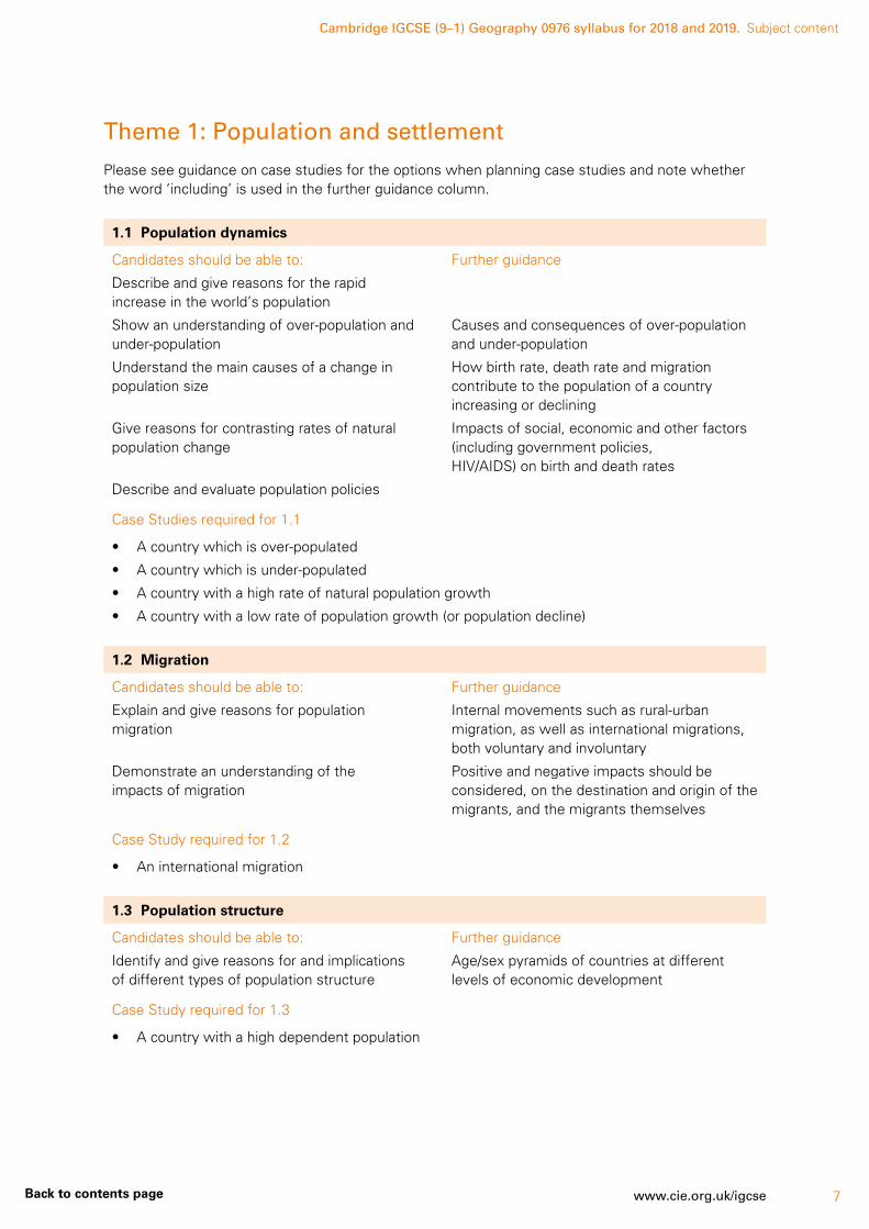
Theme 1: Population and settlement
Please see guidance on case studies for the options when planning case studies and note whether the word ‘including’ is used in the further guidance column.
1.1 Population dynamics
Candidates should be able to:
Describe and give reasons for the rapid increase in the world’s population
Show an understanding of over-population and under-population
Understand the main causes of a change in population size
Give reasons for contrasting rates of natural population change
Describe and evaluate population policies
Further guidance
Causes and consequences of over-population and under-population
How birth rate, death rate and migration contribute to the population of a country increasing or declining
Impacts of social, economic and other factors (including government policies, HIV/AIDS) on birth and death rates
Case Studies required for 1.1
• A country which is over-populated
• A country which is under-populated
• A country with a high rate of natural population growth
• A country with a low rate of population growth (or population decline)
1.2 Migration
Candidates should be able to:
Explain and give reasons for population migration
Demonstrate an understanding of the impacts of migration
Further guidance
Internal movements such as rural-urban migration, as well as international migrations, both voluntary and involuntary
Positive and negative impacts should be considered, on the destination and origin of the migrants, and the migrants themselves
Case Study required for 1.2
• An international migration
1.3 Population structure
Candidates should be able to:
Identify and give reasons for and implications of different types of population structure
Further guidance
Age/sex pyramids of countries at different levels of economic development
Case Study required for 1.3
• A country with a high dependent population
Cambridge IGCSE (9–1) Geography 0976 syllabus for 2018 and 2019. Subject content
8 www.cie.org.uk/igcse Back to contents page
1.4 Population density and distribution
Candidates should be able to:
Describe the factors influencing the density and distribution of population
Further guidance
Physical, economic, social and political factors
Case Studies required for 1.4
• A densely populated country or area (at any scale from local to regional)
• A sparsely populated country or area (at any scale from local to regional)
1.5 Settlements and service provision
Candidates should be able to:
Explain the patterns of settlement
Describe and explain the factors which may influence the sites, growth and functions of settlements
Give reasons for the hierarchy of settlements and services
Further guidance
Dispersed, linear, and nucleated settlement patterns
Influence of physical factors (including relief, soil, water supply) and other factors (including accessibility, resources)
High-, middle- and low-order settlements and services. Sphere of influence and threshold population
Case Study required for 1.5
• Settlement and service provision in an area
1.6 Urban settlements
Candidates should be able to:
Describe and give reasons for the characteristics of, and changes in, land use in urban areas
Explain the problems of urban areas, their causes and possible solutions
Further guidance
Land use zones including the Central Business District (CBD), residential areas, industrial areas and the rural-urban fringe of urban areas in countries at different levels of economic development
The effect of change in land use and rapid urban growth in an urban area including the effects of urban sprawl
Different types of pollution (air, noise, water, visual), inequality, housing issues, traffic congestion and conflicts over land use change
Case Study required for 1.6
• An urban area or areas

Cambridge IGCSE (9–1) Geography 0976 syllabus for 2018 and 2019. Subject content
9www.cie.org.uk/igcseBack to contents page
1.7 Urbanisation
Candidates should be able to:
Identify and suggest reasons for rapid urban growth
Describe the impacts of urban growth on both rural and urban areas, along with possible solutions to reduce the negative impacts
Further guidance
Reference should be made to physical, economic and social factors which result in rural depopulation and the movement of people to major cities
The effects of urbanisation on the people and natural environment. The characteristics of squatter settlements
Strategies to reduce the negative impacts of urbanisation
Case Study required for 1.7
• A rapidly growing urban area in a developing country and migration to it
Theme 2: The natural environment
Please see guidance on case studies for the options when planning case studies and note whether the word ‘including’ is used in the further guidance column.
2.1 Earthquakes and volcanoes
Candidates should be able to:
Describe the main types and features of volcanoes and earthquakes
Describe and explain the distribution of earthquakes and volcanoes
Describe the causes of earthquakes and volcanic eruptions and their effects on people and the environment
Demonstrate an understanding that volcanoes present hazards and offer opportunities for people
Explain what can be done to reduce the impacts of earthquakes and volcanoes
Further guidance
Types of volcanoes (including strato-volcanoes [composite cone] and shield volcano)
Features of volcanoes (including crater, vent, magma chamber)
Features of earthquakes (including epicentre, focus, intensity)
The global pattern of plates, their structure, and an awareness of plate movements and their effects – constructive/divergent, destructive/convergent and conservative plate boundaries
Case Studies required for 2.1
• An earthquake
• A volcano

Cambridge IGCSE (9–1) Geography 0976 syllabus for 2018 and 2019. Subject content
10 www.cie.org.uk/igcse Back to contents page
2.2 Rivers
Candidates should be able to:
Explain the main hydrological characteristics and processes which operate within rivers and drainage basins
Demonstrate an understanding of the work of a river in eroding, transporting and depositing
Describe and explain the formation of the landforms associated with these processes
Demonstrate an understanding that rivers present hazards and offer opportunities for people
Explain what can be done to manage the impacts of river flooding
Further guidance
Characteristics of rivers (including width, depth, speed of flow) and drainage basins (including watershed, tributary, confluence)
Processes which operate in a drainage basin (including interception, infiltration, throughflow, groundwater flow, evaporation, overland flow)
Forms of river valleys – long profile and shape in cross section, waterfalls, potholes, meanders, oxbow lakes, deltas, levées and flood plains
Causes of hazards including flooding and river erosion
Opportunities of living on a flood plain, a delta or near a river
Case Study required for 2.2
• The opportunities presented by a river or rivers, the associated hazards and their management
2.3 Coasts
Candidates should be able to:
Demonstrate an understanding of the work of the sea and wind in eroding, transporting and depositing
Describe and explain the formation of the landforms associated with these processes
Describe coral reefs and mangrove swamps and the conditions required for their development
Demonstrate an understanding that coasts present hazards and offer opportunities for people
Explain what can be done to manage the impacts of coastal erosion
Further guidance
Cliffs, wave-cut platforms, caves, arches, stacks, bay and headland coastlines, beaches, spits, and coastal sand dunes
Hazards including coastal erosion and tropical storms
Case Study required for 2.3
• The opportunities presented by an area or areas of coastline, the associated hazards and their management

Cambridge IGCSE (9–1) Geography 0976 syllabus for 2018 and 2019. Subject content
11www.cie.org.uk/igcseBack to contents page
2.4 Weather
Candidates should be able to:
Describe how weather data is collected
Make calculations using information from weather instruments
Use and interpret graphs and other diagrams showing weather and climate data
Further guidance
Describe and explain the characteristics, siting and use made of a Stevenson screen
Rain gauge, maximum-minimum thermometer, wet-and-dry bulb thermometer (hygrometer), sunshine recorder, barometer, anemometer and wind vane, along with simple digital instruments which can be used for weather observations; observations of types and amounts of cloud
2.5 Climate and natural vegetation
Candidates should be able to:
Describe and explain the characteristics of two climates:
• equatorial
• hot desert
Describe and explain the characteristics of tropical rainforest and hot desert ecosystems
Describe the causes and effects of deforestation of tropical rainforest
Further guidance
Climate characteristics (including temperature [mean temperature of the hottest month, mean temperature of the coolest month, annual range]; and precipitation [the amount and seasonal distribution])
Factors influencing the characteristics of these climates (including latitude, pressure systems, winds, distance from the sea, altitude and ocean currents)
Climatic graphs showing the main characteristics of temperature and rainfall of the two climates
The relationship in each ecosystem of natural vegetation, soil, wildlife and climate
Effects on the natural environment (both locally and globally) along with effects on people
Case Studies required for 2.5
• An area of tropical rainforest
• An area of hot desert
Cambridge IGCSE (9–1) Geography 0976 syllabus for 2018 and 2019. Subject content
12 www.cie.org.uk/igcse Back to contents page
Theme 3: Economic development
Please see guidance on case studies for the options when planning case studies and note whether the word ‘including’ is used in the further guidance column.
3.1 Development
Candidates should be able to:
Use a variety of indicators to assess the level of development of a country
Identify and explain inequalities between and within countries
Classify production into different sectors and give illustrations of each
Describe and explain how the proportions employed in each sector vary according to the level of development
Describe and explain the process of globalisation, and consider its impacts
Further guidance
Indicators of development (including GNP per capita, literacy, life expectancy and composite indices, e.g. Human Development Index (HDI)
Primary, secondary, tertiary and quaternary sectors
Use of indicators of development and employment structure to compare countries at different levels of economic development and over time
The role of technology and transnational corporations in globalisation along with economic factors which give rise to globalisation
Impacts at a local, national and global scale
Case Study required for 3.1
• A transnational corporation and its global links
3.2 Food production
Candidates should be able to:
Describe and explain the main features of an agricultural system: inputs, processes and outputs
Recognise the causes and effects of food shortages and describe possible solutions to this problem
Further guidance
Farming types: commercial and subsistence; arable, pastoral and mixed; intensive and extensive
The influence of natural and human inputs on agricultural land use. Inputs including natural inputs (relief, climate and soil) and human inputs (economic and social). Their combined influences on the scale of production, methods of organisation and the products of agricultural systems
Natural problems which cause food shortages (including drought, floods, tropical storms, pests) along with economic and political factors (including low capital investment, poor distribution/transport difficulties, wars)
The negative effects of food shortages, but also the effects of food shortages in encouraging food aid and measures to increase output
Case Studies required for 3.2
• A farm or agricultural system
• A country or region suffering from food shortages

Cambridge IGCSE (9–1) Geography 0976 syllabus for 2018 and 2019. Subject content
13www.cie.org.uk/igcseBack to contents page
3.3 Industry
Candidates should be able to:
Demonstrate an understanding of an industrial system: inputs, processes and outputs (products and waste)
Describe and explain the factors influencing the distribution and location of factories and industrial zones
Further guidance
Industry types: manufacturing, processing, assembly and high technology industry
The influence of factors including land, labour, raw materials and fuel and power, transport, markets and political factors
Their combined influences on the location, scale of production, methods of organisation and the products of the system
Industrial zones and/or factories with respect to locational and siting factors
Case Study required for 3.3
• An industrial zone or factory
3.4 Tourism
Candidates should be able to:
Describe and explain the growth of tourism in relation to the main attractions of the physical and human landscape
Evaluate the benefits and disadvantages of tourism to receiving areas
Demonstrate an understanding that careful management of tourism is required in order for it to be sustainable
Further guidance
Case Study required for 3.4
• An area where tourism is important
3.5 Energy
Candidates should be able to:
Describe the importance of non-renewable fossil fuels, renewable energy supplies, nuclear power and fuelwood; globally and in different countries at different levels of development
Evaluate the benefits and disadvantages of nuclear power and renewable energy sources
Further guidance
Non-renewable fossil fuels including coal, oil and natural gas. Renewable energy supplies including geothermal, wind, HEP, wave and tidal power, solar power and biofuels
Case Study required for 3.5
• Energy supply in a country or area
Cambridge IGCSE (9–1) Geography 0976 syllabus for 2018 and 2019. Subject content
14 www.cie.org.uk/igcse Back to contents page
3.6 Water
Candidates should be able to:
Describe methods of water supply and the proportions of water used for agriculture, domestic and industrial purposes in countries at different levels of economic development
Explain why there are water shortages in some areas and demonstrate that careful management is required to ensure future supplies
Further guidance
Methods of water supply (including reservoirs/dams, wells and bore holes, desalination)
The impact of lack of access to clean water on local people and the potential for economic development
Case Study required for 3.6
• Water supply in a country or area
3.7 Environmental risks of economic development
Candidates should be able to:
Describe how economic activities may pose threats to the natural environment, locally and globally
Demonstrate the need for sustainable development and management
Understand the importance of resource conservation
Further guidance
Threats to the natural environment including soil erosion, desertification, enhanced global warming and pollution (water, air, noise, visual)
Case Study required for 3.7
• An area where economic development is taking place causing the environment to be at risk
Cambridge IGCSE (9–1) Geography 0976 syllabus for 2018 and 2019.
15www.cie.org.uk/igcseBack to contents page
4 Details of the assessment
For information on the Assessment objectives (AOs), see section 5.
Paper 1 – Geographical Themes
Written paper, 1 hour 45 minutes, 75 marks
All candidates take Paper 1. Questions on the paper are resource based. The resources are for interpretation and analysis in answering a question or part questions. Candidates will be expected to know the location of the continents. All of the other information required to answer these part questions is within the resource itself. No previous knowledge is needed of the particular illustration presented. What is required is that candidates use the data provided to illustrate their understanding of the particular concept being assessed.
Questions are structured with gradients of difficulty and combine resource-based tasks and free-response writing requiring place-specific information.
The resources may be:
• photographs
• map extracts
• sketch maps
• drawings
• diagrams
• graphs
• text extracts
• statistics and tables of data
• satellite images
• use of GIS.
Resource materials are selected from various world areas and, as a result, candidates may be dealing with world areas with which they are not familiar. The resources do not require specific regional knowledge. This should be stressed to the candidates as they may be influenced in their question selection by the nature/location of the resource included.
Candidates should refer to appropriate case studies to illustrate the individual themes.
A case study may be selected because it relates to:
• the local school area
• a contemporary development such as the occurrence of a natural hazard in part of the world
• a particular illustration with which the teacher is familiar
• a presentation in a newspaper, web pages, on video, film, a well documented illustration in a textbook, etc.
A case study may also be based on a field study undertaken as part of the work for Component 3 (Coursework) or Paper 4 (Alternative to Coursework). Specific questions based on fieldwork will not be set in Paper 1, but candidates may use this information to illustrate answers in Paper 1.

Cambridge IGCSE (9–1) Geography 0976 syllabus for 2018 and 2019. Details of the assessment
16 www.cie.org.uk/igcse Back to contents page
Case studies should provide candidates with details of a particular illustration which can be profitably used in answers to certain questions on Paper 1. Some part questions on the paper require that reference is made to information from specific case studies made by candidates and opportunity is also provided for candidates to volunteer such details in answering other part questions.
Specific named illustrations of case studies have not been included in the syllabus. This is to give teachers complete freedom in selecting examples which they feel are most appropriate for their candidates.
It is important that candidates comply with the instructions for Paper 1. Only three questions are to be selected, one from each of the three sections. Sometimes within individual questions a choice is provided. It is very important that candidates make the correct choice and do not answer more than is required.
Candidates are also advised to note the sub-marks printed on the question paper. These are included in order to guide candidates to the amount of detail and length of response anticipated and to allow them to manage their time effectively.
Paper 2 – Geographical Skills
Written paper, 1 hour 30 minutes, 60 marks
All candidates take Paper 2 and must answer all the questions. The paper is based on testing skills of application, interpretation and analysis of geographical information, e.g. topographical maps, other maps, diagrams, graphs, tables of data, written material, photographs and pictorial material, and on the application of graphical and other techniques as appropriate. The questions in Paper 2 do not require specific information of place. Questions within Paper 2 which require knowledge and understanding (AO1) will be based on topics from the three main syllabus themes (see section 3).
Equipment required for Paper 2
Candidates should have the following in the examination room:
• a pencil, rubber, ruler, a protractor and a calculator
• access to a sheet of plain paper for measuring distance or for assisting with cross-sections on the large-scale map.
Mapwork question
One question will be based on a large-scale map. The large-scale maps chosen for examination purposes will be on a scale of either 1:25 000 or 1:50 000 and will always contain a full key.
One third of the marks available on this paper are awarded to the mapwork question and, therefore, it is essential that candidates are proficient in map reading and interpretation skills to enable them to describe and analyse large-scale maps.
NOTE: All answers to this question must be based on map evidence only.

Cambridge IGCSE (9–1) Geography 0976 syllabus for 2018 and 2019. Details of the assessment
17www.cie.org.uk/igcseBack to contents page
Candidates should be able to use a co-ordinate reference system and be able to give and to read four-figure and six-figure grid references to locate places. For example, the four-figure reference for the dot is 4665 while the six-figure grid reference for the dot is 463654.
46 47
4665
66
65
66
0
0
1
2
3
4
5
6
7
8
9
1 2 3 4 5 6 7 8 947
1st Reading (EASTINGS)
2nd Reading(NORTHINGS)
To give the six-figure grid reference, first identify the grid square, in this case 4665. The third figure is obtained by dividing the space between grid lines 46 and 47 into ten equal parts. Similarly, the sixth figure is obtained by a similar division of the gap between northings 65 and 66. This results in a grid reference of 463654 for the dot and 460650 for the star. It should be noted that the first tenth is 0 and the last tenth is 9 in the divided grid square.
Candidates should be able to give directions, both in terms of a 16-point compass (such as north, north-north east, north east, etc.) and as a bearing from grid north of one place from another. It is, therefore, important that candidates have protractors in the examination room with them.
Candidates should be able to measure horizontal distances. This is most accurately done by using a straight-edged piece of paper and the scale line. If the line to be measured is curved, divide the curve into straight sections and rotate the paper after each straight section to follow the next straight section. Finally place the completed straight-edged piece of paper along the linear scale line on the map extract and read off the distance in kilometres/metres. This method avoids complicated mathematical calculations which can arise when rulers are used.
Contour reading, which enables candidates to calculate differences in height, should be practised.
Cross sections may be set for interpretation and candidates may be required to construct or complete a cross section.
Candidates should be able to translate the scale of a feature by describing its size and shape in real terms. They should also be proficient in using the key to the map to enable them to identify features on the map.
Candidates should be able to draw inferences about the physical and human landscape by interpretation of map evidence such as patterns of relief, drainage, settlement, communication and land use.
Candidates are advised to practise identifying basic landscape features such as river valleys and uplands, and to give brief descriptions of them using appropriate geographical terms (such as ridge, plateau, scarp, flood plain) and simple adjectives showing an appreciation of their nature (such as broad, flat, steep-sided, deeply cut, gently sloping). To interpret these maps, candidates should be able to recognise essential differences in density of drainage, stream patterns, gradients or sizes of streams in relation to the relief. They should be able to describe the physical features of coastlines and the shape and form of river channels as they are shown on large-scale maps.
Cambridge IGCSE (9–1) Geography 0976 syllabus for 2018 and 2019. Details of the assessment
18 www.cie.org.uk/igcse Back to contents page
Practice in describing variations in land use should be part of the preparation for the examination. The interpretation of ‘human’ features would also require candidates to recognise and analyse patterns of settlement (dispersed, nucleated, linear) and candidates should be able to draw sketch maps illustrating these patterns. Candidates should be able to interpret and describe features of urban morphology as represented on large-scale maps and be able to describe the functions of and services provided by settlements. They should also be able to give reasons for the site and growth of individual settlements. Communication networks should be recognised in terms of their type and density in relation to physical and human features.
Maps, diagrams, graphs, tables of data, written material
Questions will be set using some or all of these resources. They should be regarded as important ways of representing geographical data. They may be used to illustrate a basic principle and it is essential that candidates should be directed towards their interpretation. For example, a population pyramid may be used to illustrate the age and sex structure of a country. With this, a candidate may be required to describe the broad features of the population structure to show comparisons and contrasts between the male and female populations, the working and non-working population and the young-, middle- and old-age groups.
Maps based on global and other scales may be used and candidates may be asked to identify and describe significant features of the human and physical landscape on them, e.g. population distribution, population movements, transport networks, settlement layout, relief and drainage, etc. Candidates may be asked to recognise patterns and deduce relationships.
It is expected that candidates will be able to extract specified geographical information from graphs, diagrams, tables of data and written material. Various types of graphs, maps and diagrams (for example pictograms, line graphs, bar graphs, divided bar graphs, histograms, kite diagrams, flow diagrams, wind rose graphs, dispersion graphs, isoline maps, scatter graphs, choropleth maps, pie graphs, triangular graphs and radial graphs) may be used and candidates may be asked to describe variations and identify trends in information. Graphs may show, for example, temperature, birth rate, death rate, energy, rainfall distribution, river discharge, etc.
Candidates may be required to plot information on graphs when axes and scales are provided.
Data tables may provide information on physical phenomena, on economic activities, on population, on settlement, on agricultural and manufacturing output, etc. and candidates may be asked to describe and analyse features and trends from the data provided. They may also be asked to suggest an appropriate form of graphical representation for the data provided.
Written material may be extracts from books, periodicals and newspapers, and candidates will be expected to show an understanding of the material presented.
Photographic and pictorial material (including field sketches)
Oblique photographs will be used. Candidates should be able to describe human and physical landscapes (landforms, natural vegetation, land use and settlement) and geographical phenomena from photographs, aerial photographs, satellite images and GIS. Simple descriptions only will be required. Candidates may be expected to add specified detail on maps or other material provided, thereby applying geographical knowledge and understanding. Field sketches of physical and human landscapes may be used to stimulate geographical description and annotation. Cartoons illustrating a geographical theme may be set for interpretation and analysis.
Candidates may also be asked to use supporting material in conjunction with large-scale maps to identify, describe and analyse features and thereby recognise patterns and deduce trends.
Cambridge IGCSE (9–1) Geography 0976 syllabus for 2018 and 2019. Details of the assessment
19www.cie.org.uk/igcseBack to contents page
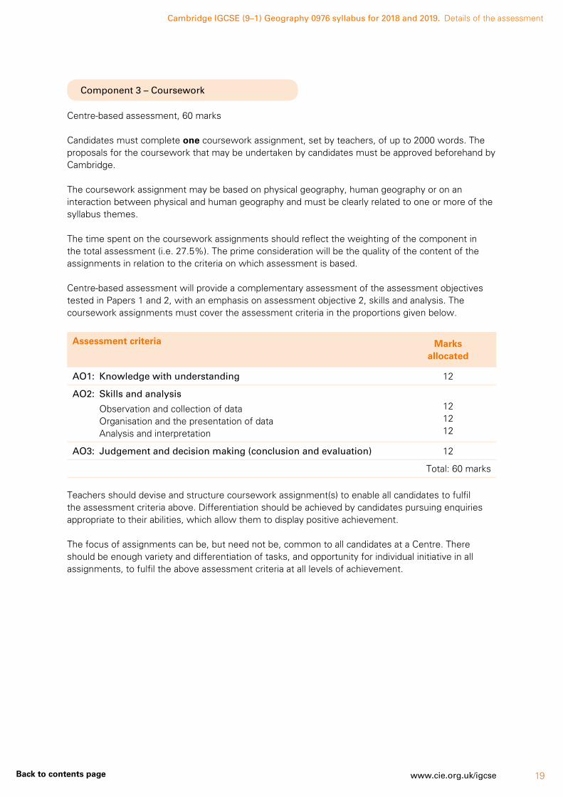
Component 3 – Coursework
Centre-based assessment, 60 marks
Candidates must complete one coursework assignment, set by teachers, of up to 2000 words. The proposals for the coursework that may be undertaken by candidates must be approved beforehand by Cambridge.
The coursework assignment may be based on physical geography, human geography or on an interaction between physical and human geography and must be clearly related to one or more of the syllabus themes.
The time spent on the coursework assignments should reflect the weighting of the component in the total assessment (i.e. 27.5%). The prime consideration will be the quality of the content of the assignments in relation to the criteria on which assessment is based.
Centre-based assessment will provide a complementary assessment of the assessment objectives tested in Papers 1 and 2, with an emphasis on assessment objective 2, skills and analysis. The coursework assignments must cover the assessment criteria in the proportions given below.
Assessment criteria Marks allocated
AO1: Knowledge with understanding 12
AO2: Skills and analysis
Observation and collection of dataOrganisation and the presentation of dataAnalysis and interpretation
121212
AO3: Judgement and decision making (conclusion and evaluation) 12
Total: 60 marks
Teachers should devise and structure coursework assignment(s) to enable all candidates to fulfil the assessment criteria above. Differentiation should be achieved by candidates pursuing enquiries appropriate to their abilities, which allow them to display positive achievement.
The focus of assignments can be, but need not be, common to all candidates at a Centre. There should be enough variety and differentiation of tasks, and opportunity for individual initiative in all assignments, to fulfil the above assessment criteria at all levels of achievement.

Cambridge IGCSE (9–1) Geography 0976 syllabus for 2018 and 2019. Details of the assessment
20 www.cie.org.uk/igcse Back to contents page
Setting up a coursework assignment
Teachers should structure each coursework assignment to promote:
• the acquisition of geographical knowledge
• the understanding and application of ideas
• the development of skills and the clarification of values in a geographical context.
The coursework assignment should follow the accepted ‘route to geographical enquiry’ as below.
The route to geographical enquiry
1 Identification of issue, question or problem
A topic for investigation is recognised through observation, discussion, reading or previous study. The design of hypotheses to test the issue, question or problem.
2 Objectives of the study are defined
The objectives of the study are defined in specific terms.
Decisions are made concerning:
(a) what data is relevant to the study
(b) how the data can be collected.
3 Collection of data Candidates carry out a group or individual set of tasks, which may include fieldwork to collect primary data, such as undertaking questionnaires, mapping or sketching, observation, recording counts or measurements. This may also involve gathering data from secondary sources such as census information, the internet, published maps, books, newspapers or magazines.
4 Selection and collation of data
The teacher may collate data for class use. Candidates select data to develop the aims or hypotheses for the topic.
5 Presentation and recording of the results
Candidates individually record results and present findings in appropriate forms using a variety of maps, graphs, etc.
6 Analysis and interpretation Candidates individually analyse and interpret their findings in response to the issue/question/problem with reference to relevant geographical concepts.
7 Making effective conclusions, evaluation and suggestions for further work
Candidates individually draw conclusions from their findings and make evaluations related to the original objectives. If appropriate, comments may be made on the limitations of the data and possibilities for further study.

Cambridge IGCSE (9–1) Geography 0976 syllabus for 2018 and 2019. Details of the assessment
21www.cie.org.uk/igcseBack to contents page
Examples of suitable coursework assignments
• The varying pattern of land use with distance from the centre of a settlement
• The differences between residential environments within a settlement
• The hierarchical distribution of shopping centres/leisure amenities within a settlement
• Possible locations for a new hypermarket
• Does the influence of a town decrease with distance from it?
• The problems caused by an uneven/unreliable supply of water within a selected area
• A study of agricultural patterns within an area
• Ways in which the industrial structure has changed in an area
• Are the leisure facilities of an area/town adequate for the needs of its population?
• The development of tourism in an area
• An analysis of the distribution, nature and possible reasons for the formation of selected landforms, e.g. along the course of a stream or at the coast
• The effects of anticyclones and depressions in influencing the weather recordings at a school weather station
• The nature of the environmental conflicts in an area
• Problems of landscape management and conservation in a national park
Each coursework assignment outline, showing the specific ‘route to the enquiry’, should be submitted to Cambridge for approval and comment in advance to ensure it complies with the requirements of the syllabus.
An example of an outline submission to Cambridge
An investigation related to topic 1.5: Settlements and service provision:
‘Is there a pattern to the distribution of settlements in area X and the types of services they offer?’
1 Identification of issue, question or problem. Definition of the area to be studied. Relationship to concepts studied for 1.5 of the syllabus – in particular, site, situation and functions of small settlements; services in relation to settlements – threshold, range of a service. Candidates will select hypotheses from the following list and devise one additional statement:
‘Larger settlements will have a higher number of services.’
‘Residents travel further to obtain high-level goods.’
‘Services in smaller settlements serve the local community.’
‘The number of services in smaller settlements has decreased recently.’
2 Objectives of the study are defined – the characteristics of each settlement – its site, situation, size, population, shops and other services, sphere of influence.
How may each of these characteristics be investigated?
What data collection methods are appropriate? The role of map study of both recent and older maps, counts, observations and questionnaire layout and sampling techniques are discussed as a group and decisions made.

Cambridge IGCSE (9–1) Geography 0976 syllabus for 2018 and 2019. Details of the assessment
22 www.cie.org.uk/igcse Back to contents page
3 Collection of data – the methods of field investigation are outlined and carried out.
The site and situation of the settlements are described by combining visual evidence recorded at each location with mapwork using a large-scale map.
The size of each settlement – a count of the number of inhabited and uninhabited houses.
The population of each settlement calculated using an average head-per-household figure or secondary data found.
Recordings are made of the numbers and types of services found in each settlement – shops, telephone boxes, post boxes, bus stops, etc. Candidates are encouraged to make individual additional observations and take photographs.
Questionnaires to residents to identify spheres of influence. More able candidates will devise three questions of their own to include in the group questionnaire.
4 Selection and collation of data – to be completed by the teacher but candidates will select the data related to their chosen hypotheses.
5 Presentation and recording of results – drawing of maps to show settlement distribution, desire lines for certain services, graphs, etc. Candidates will select appropriate graphs to present their results.
6 Analysis and interpretation – candidates identify trends, patterns and findings, and explain what they mean in relation to what they set out to investigate.
7 Making effective conclusions, evaluation and suggestions for further work – candidates draw conclusions and identify the key pieces of evidence that support them. The evaluation indicates what worked well and suggests improvements in the light of hindsight. Suggestions for future lines of enquiry are identified.
Teacher guidance
The teacher is required to devise the coursework assignment, therefore appropriate guidance is an essential component of coursework.
Appropriate guidance includes:
• introduction of the ‘route to geographical enquiry’
• outlining the purpose and aims of the assignment
• teaching the relevant geographical concepts to allow the assignment to be placed in context
• discussion and instruction on data collection methods
• introduction of all appropriate presentation techniques
• ensuring a clear understanding of the requirements for the finished assignment including word counts and individual initiative required to access higher levels in the generic mark scheme.
Some candidates will require more individual guidance in their choice of graphs, analytical comments or conclusions. The extent of guidance should be reflected in the level of marks awarded.
Undertaking coursework assignments
The amount of time devoted to any one assignment will vary. However, in practice, assignments should normally assess the outcomes of about four or five weeks’ work in the classroom plus homework and should usually follow a programme of introductory work. The coursework assignment should be incorporated into the teaching syllabus at an appropriate time during the course.
Cambridge IGCSE (9–1) Geography 0976 syllabus for 2018 and 2019. Details of the assessment
23www.cie.org.uk/igcseBack to contents page
The use of computers for the production of coursework for geography is encouraged, both for word-processed text and for computer-generated maps, diagrams and graphs. Candidates will gain credit for selecting and using the most appropriate method for data presentation. Candidates should be reminded that hand-drawn maps, diagrams and graphs can sometimes be more appropriate and more useful than those generated by computer.
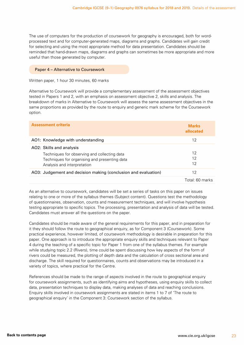
Paper 4 – Alternative to Coursework
Written paper, 1 hour 30 minutes, 60 marks
Alternative to Coursework will provide a complementary assessment of the assessment objectives tested in Papers 1 and 2, with an emphasis on assessment objective 2, skills and analysis. The breakdown of marks in Alternative to Coursework will assess the same assessment objectives in the same proportions as provided by the route to enquiry and generic mark scheme for the Coursework option.
Assessment criteria Marks allocated
AO1: Knowledge with understanding 12
AO2: Skills and analysis
Techniques for observing and collecting dataTechniques for organising and presenting dataAnalysis and interpretation
121212
AO3: Judgement and decision making (conclusion and evaluation) 12
Total: 60 marks
As an alternative to coursework, candidates will be set a series of tasks on this paper on issues relating to one or more of the syllabus themes (Subject content). Questions test the methodology of questionnaires, observation, counts and measurement techniques, and will involve hypothesis testing appropriate to specific topics. The processing, presentation and analysis of data will be tested. Candidates must answer all the questions on the paper.
Candidates should be made aware of the general requirements for this paper, and in preparation for it they should follow the route to geographical enquiry, as for Component 3 (Coursework). Some practical experience, however limited, of coursework methodology is desirable in preparation for this paper. One approach is to introduce the appropriate enquiry skills and techniques relevant to Paper 4 during the teaching of a specific topic for Paper 1 from one of the syllabus themes. For example while studying topic 2.2 (Rivers), time could be spent discussing how key aspects of the form of rivers could be measured, the plotting of depth data and the calculation of cross sectional area and discharge. The skill required for questionnaires, counts and observations may be introduced in a variety of topics, where practical for the Centre.
References should be made to the range of aspects involved in the route to geographical enquiry for coursework assignments, such as identifying aims and hypotheses, using enquiry skills to collect data, presentation techniques to display data, making analyses of data and reaching conclusions. Enquiry skills involved in coursework assignments are stated in items 1 to 7 of ‘The route to geographical enquiry’ in the Component 3: Coursework section of the syllabus.

Cambridge IGCSE (9–1) Geography 0976 syllabus for 2018 and 2019. Details of the assessment
24 www.cie.org.uk/igcse Back to contents page
Enquiry skills for Paper 4
1 Formulating aims and hypotheses
Candidates should be familiar with hypotheses as statements that form the basis of coursework assignments. The hypotheses may investigate a geographical concept, e.g. ‘A CBD has the highest concentration of comparison shops.’ Collecting relevant data, analysis and drawing conclusions using the data as evidence can test these.
2 Enquiry skills to collect data
Questions on this paper will test knowledge and application of the methodology used in the following range of data-collection enquiry skills.
Questionnaires – Questionnaires can be oral or written to gain information from an individual or a group of individuals. Suitable themes in the syllabus where questionnaires may be appropriately studied include spheres of influence, use of services, shopping habits, a farm study, a factory or industrial study, leisure activities, tourism, or attitudes of the public to developments associated with resource development. Consideration should be given to factors influencing the successful design of questionnaires, e.g. layout, format of questions, the appropriate wording of questions and the number of questions. The practical considerations of conducting a questionnaire, e.g. the sampling methods, pilot survey and location of survey should also be discussed.
Observation – Examples of using observations as an enquiry skill to collect data include the recording of land use in an urban area or observations of river or coastal features. Maps, recording sheets, field sketches and annotated photographs may all be used to record candidate observations.
Counts – Pedestrian and traffic counts are two significant examples of this enquiry skill. Appropriate methods for recording the counts should be discussed, including the layout of recording sheets, instructions and the necessary information required to identify the sheet following the count (i.e. time, date, location and name of recorder).
Measurement – When recording measurements, due consideration should be given to planning the layout of the recording sheet, the location of instruments and the sampling methods adopted to provide reliable data. Knowledge of the equipment used in measurement is required, such as the quadrat, the clinometer and the pebbleometer or callipers. Candidates should be familiar with river measurements of channel width, depth, speed of flow and the size and shape of bedload; beach studies of beach profile, the size and shape of pebbles and the movement of beach material and weather study instruments closely linked to theme 2 as well as measurement techniques associated with human fieldwork such as survey strategies and pedestrian/traffic counts.
3 Data-presentation techniques
A knowledge of the illustrative techniques to present data across the topics for Paper 4 is required. This should include various types of graphs, maps and diagrams (for example line graphs, bar graphs, divided bar graphs, histograms, flow diagrams, wind-rose graphs, isoline maps, scatter graphs, pie graphs, triangular graphs, radial graphs, dispersion graphs, choropleth maps, kite diagrams and pictograms).
4 Analysis
Candidates should be able to describe the patterns in data presented in graphs and tables of results. Reference to relevant geographical knowledge and understanding is often required in the interpretation of the data.
5 Making conclusions
Using the evidence from the data, candidates should be able to make judgements on the validity of the original hypothesis or aims of the assignment. Reference is also required to the reliability of the collected data and a critical evaluation of the chosen data-collection methods, along with suggestions of other possible hypotheses and extension work.
Cambridge IGCSE (9–1) Geography 0976 syllabus for 2018 and 2019. Details of the assessment
25www.cie.org.uk/igcseBack to contents page
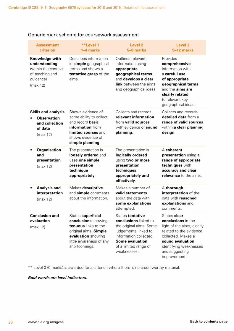
Coursework assessment
For the assignment, teachers must use the generic mark scheme on the following page which allocates marks out of a total of 60 for this component.
It is recommended that the generic mark scheme is studied closely at the same time that outlines for the coursework assignments are prepared. This should ensure, for example, that topics will provide opportunities for different levels of achievement to be demonstrated for each of the assessment criteria.
The best approach to marking a coursework assignment is using a two-stage strategy:
Stage 1: Using the criteria stated in the generic mark scheme, identify the level of achievement (Levels 1–3) for each assessment criterion.
Stage 2: For each assessment criterion, decide which mark within a level of achievement best fits the standard achieved for an assignment.
Candidates’ marks for Geography must be recorded on the Individual Candidate Record Card produced by Cambridge. These forms, and the instructions for completing them, may be downloaded from www.cie.org.uk/samples. The database will ask you for the syllabus code (i.e. 0976) and your Centre number, after which it will take you to the correct forms. Follow the instructions when completing each form.
Cambridge IGCSE (9–1) Geography 0976 syllabus for 2018 and 2019. Details of the assessment
26 www.cie.org.uk/igcse Back to contents page
Generic mark scheme for coursework assessment
Assessment criterion
**Level 1 1–4 marks
Level 2 5–8 marks
Level 3 9–12 marks
Knowledge with understanding (within the context of teaching and guidance)
(max 12)
Describes information in simple geographical terms and shows a tentative grasp of the aims.
Outlines relevant information using appropriate geographical terms and develops a clear link between the aims and geographical ideas.
Provides comprehensive information with a careful use of appropriate geographical terms and the aims are clearly related to relevant key geographical ideas.
Skills and analysis
• Observation and collection of data
(max 12)
Shows evidence of some ability to collect and record basic information from limited sources and shows evidence of simple planning.
Collects and records relevant information from valid sources with evidence of sound planning.
Collects and records detailed data from a range of valid sources within a clear planning design.
• Organisation and presentation
(max 12)
The presentation is loosely ordered and uses one simple presentation technique appropriately.
The presentation is logically ordered using two or more presentation techniques appropriately and effectively.
A coherent presentation using a range of appropriate techniques with accuracy and clear relevance to the aims.
• Analysis and interpretation
(max 12)
Makes descriptive and simple comments about the information.
Makes a number of valid statements about the data with some explanations attempted.
A thorough interpretation of the data with reasoned explanations and comments.
Conclusion and evaluation
(max 12)
States superficial conclusions showing tenuous links to the original aims. Simple evaluation showing little awareness of any shortcomings.
States tentative conclusions linked to the original aims. Some judgements linked to information collected. Some evaluation of a limited range of weaknesses.
States clear conclusions in the light of the aims, clearly related to the evidence collected. Makes a sound evaluation identifying weaknesses and suggesting improvement.
** Level 0 (0 marks) is awarded for a criterion where there is no credit-worthy material.
Bold words are level indicators.

Cambridge IGCSE (9–1) Geography 0976 syllabus for 2018 and 2019. Details of the assessment
27www.cie.org.uk/igcseBack to contents page
Coursework moderation
Internal moderation
If more than one teacher in a Centre is involved in the internal assessments, arrangements must be made within the Centre for all candidates to be assessed to a common standard. The sample the Centre submits to Cambridge should include the marking of each teacher. Please contact Cambridge if you require guidance on internal moderation.
The internally moderated marks for all candidates must be recorded on the Coursework Assessment Summary Form. This form, and the instructions for completing it, may be downloaded from www.cie.org.uk/samples. The database will ask you for the syllabus code (i.e. 0976) and your Centre number, after which it will take you to the correct form. Follow the instructions when completing the form.
The Centre assessments are then subject to external moderation.
External moderation
External moderation of internal assessment is carried out by Cambridge.
• Centres must submit the internally assessed marks of all candidates to Cambridge.
• Centres must also submit the internally assessed work of a sample of candidates to Cambridge. The Cambridge Handbook, available on our website, provides details of which candidates are to be included in the sample.
If more than one teacher has assessed the Coursework, the sample should include examples of the marking of each teacher.
For information, dates and methods of submission of the coursework marks and sample, please refer to the Cambridge Handbook and Samples Database www.cie.org.uk/samples
Feedback from moderators
Moderators will comment on a Centre’s application of the generic mark scheme in a short report.
Cambridge IGCSE (9–1) Geography 0976 syllabus for 2018 and 2019.
28 www.cie.org.uk/igcse Back to contents page
5 Assessment objectives
The assessment objectives (AOs) are:
AO1 Knowledge with understanding
AO2 Skills and analysis
AO3 Judgement and decision making
AO1 Knowledge with understanding
Candidates should be able to demonstrate knowledge and understanding of:
• the wide range of processes, including human actions, contributing to the development of
(a) physical, economic and social environments and their effects on the landscape
(b) spatial patterns and interactions which are important within these environments
• the relationships between human activity and the environment
• the importance of scale (whether local, regional or global)
• the changes which occur through time in places, landscapes and spatial distribution.
AO2 Skills and analysis
Candidates should be able to:
• interpret and analyse geographical data
• use and apply geographical knowledge and understanding to maps and in numerical, diagrammatic, pictorial, photographic and graphical form
• use geographical data to recognise patterns in such data and to deduce relationships
• select and show understanding of techniques for observing and collecting data
• select and use techniques for organising and presenting data.
AO3 Judgement and decision making
Through their geographical training, candidates should be able to:
• reason and make judgements and decisions, including evaluation and conclusions, which demonstrate, where appropriate
(a) an appreciation of the attitudes, values and beliefs of others in issues which have a geographical dimension
(b) an awareness of the contrasting opportunities and constraints of people living in different places and under different physical and human conditions
(c) a willingness to review their own attitudes in the light of the views of others and new knowledge acquired
• make judgements and decisions and recognise how these are made within a geographical context as affected and constrained by
(a) the physical and human contexts in which decisions are made
(b) the values and perceptions of differing groups or individuals
(c) the choices available to decision makers
(d) the increasing level of global interdependence and the need for sustainable development.
Cambridge IGCSE (9–1) Geography 0976 syllabus for 2018 and 2019. Assessment objectives
29www.cie.org.uk/igcseBack to contents page
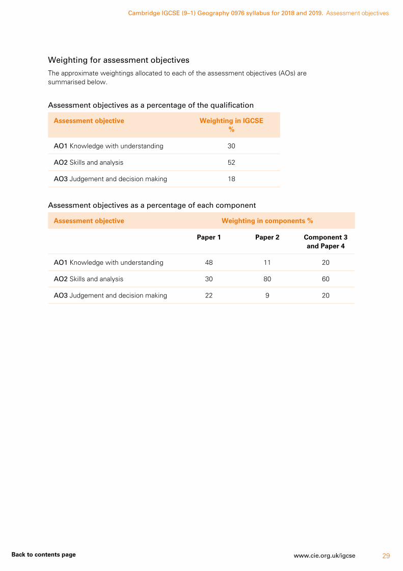
Weighting for assessment objectives
The approximate weightings allocated to each of the assessment objectives (AOs) are summarised below.
Assessment objectives as a percentage of the qualification
Assessment objective Weighting in IGCSE %
AO1 Knowledge with understanding 30
AO2 Skills and analysis 52
AO3 Judgement and decision making 18
Assessment objectives as a percentage of each component
Assessment objective Weighting in components %
Paper 1 Paper 2 Component 3 and Paper 4
AO1 Knowledge with understanding 48 11 20
AO2 Skills and analysis 30 80 60
AO3 Judgement and decision making 22 9 20

Cambridge IGCSE (9–1) Geography 0976 syllabus for 2018 and 2019.
30 www.cie.org.uk/igcse Back to contents page
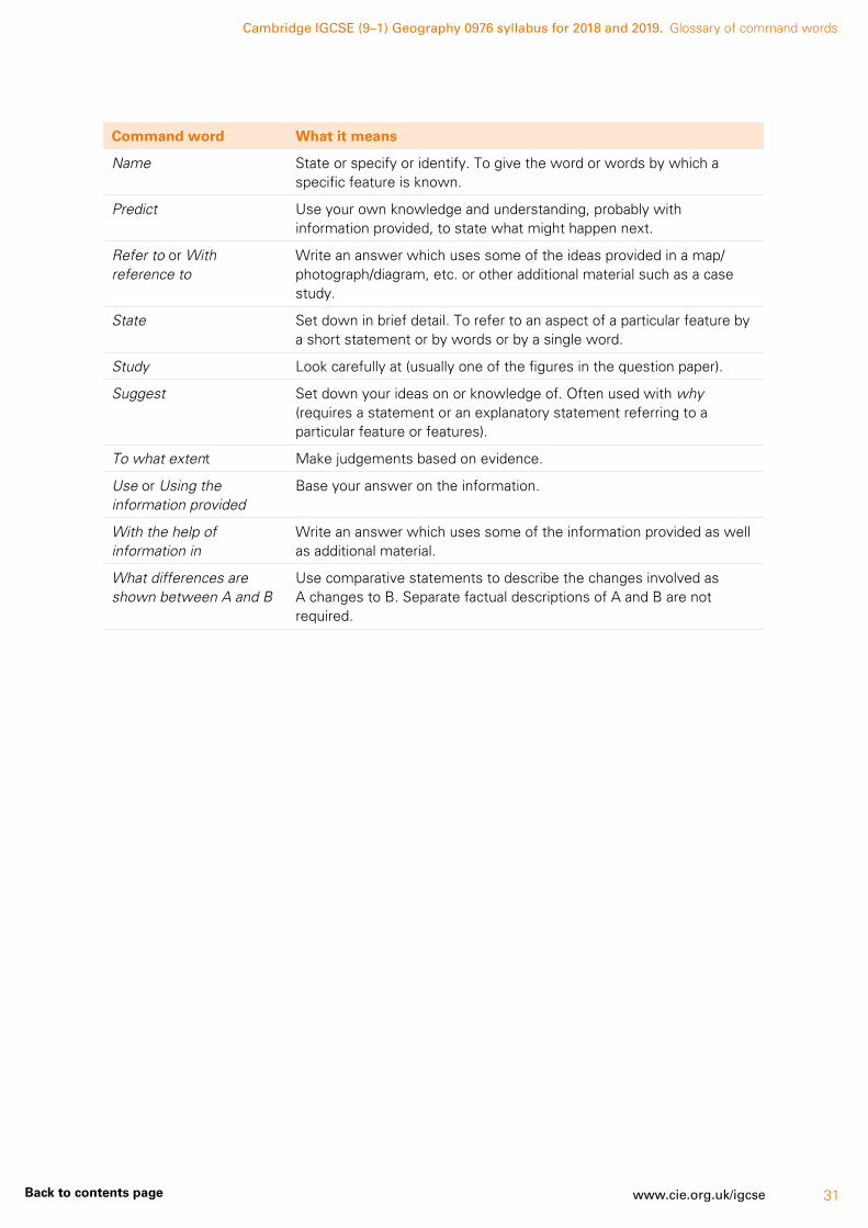
6 Glossary of command words
Command words are those words in a question that tell the candidate what they have to do. The glossary has been deliberately kept brief with respect to the descriptions of meanings. Candidates should appreciate that the meaning of a term must depend in part on its context.
This glossary is neither exhaustive nor definitive and should be used specifically with the geography papers.
Command word What it means
Define or State the meaning of or What is meant by
Give the meaning or definition of a word or phrase.
Describe Write what something is like or where it is. Describe may be used for questions about resources in the question paper (describe the trend of a graph, the location of a settlement on a map, etc.). It may also be used when you need to describe something from memory (describe a meander, etc.).
It is often used with other command words such as Name and describe (name the feature and say what it is like), Describe and explain (say what it is like and give reasons for this).
Devise or Plan Present a particular feature such as a form or questionnaire to meet a specific requirement or requirements.
Draw Make a sketch of. Often used with a labelled diagram (draw a diagram/illustration with written notes to identify its features).
Explain or Account for or Give reasons for
Write about why something occurs or happens.
Give your views or Comment on
Say what you think about something.
How far do you agree Use evidence to make judgements about a statement.
Identify Pick out something from information you have been given.
Illustrate your answer Account for by using specific examples or diagrams. (Often used alongside with a labelled diagram).
Insert or Label Add specific names or details to an illustrative technique in response to a particular requirement.
Justify Say why you chose something or why you think in a certain way.
List Identify and name a number of features to meet a particular purpose.
Locate Find where something is placed or state where something is found or mark it on a map or diagram.
Measure Implies that the quantity concerned can be directly obtained from a suitable measuring instrument.
Cambridge IGCSE (9–1) Geography 0976 syllabus for 2018 and 2019. Glossary of command words
31www.cie.org.uk/igcseBack to contents page
Command word What it means
Name State or specify or identify. To give the word or words by which a specific feature is known.
Predict Use your own knowledge and understanding, probably with information provided, to state what might happen next.
Refer to or With reference to
Write an answer which uses some of the ideas provided in a map/photograph/diagram, etc. or other additional material such as a case study.
State Set down in brief detail. To refer to an aspect of a particular feature by a short statement or by words or by a single word.
Study Look carefully at (usually one of the figures in the question paper).
Suggest Set down your ideas on or knowledge of. Often used with why (requires a statement or an explanatory statement referring to a particular feature or features).
To what extent Make judgements based on evidence.
Use or Using the information provided
Base your answer on the information.
With the help of information in
Write an answer which uses some of the information provided as well as additional material.
What differences are shown between A and B
Use comparative statements to describe the changes involved as A changes to B. Separate factual descriptions of A and B are not required.
Cambridge IGCSE (9–1) Geography 0976 syllabus for 2018 and 2019.
32 www.cie.org.uk/igcse Back to contents page
7 What else you need to know
This section is an overview of other information you need to know about this syllabus. It will help to share the administrative information with your exams officer so they know when you will need their support. Find more information about our administrative processes at www.cie.org.uk/examsofficers
Before you start
Previous study
We recommend that learners starting this course should have studied a Geography curriculum such as the Cambridge Secondary 1 programme or equivalent national educational framework. Learners in England will normally have followed the Key Stage 3 programme of study within the National Curriculum for England.
Guided learning hours
Cambridge IGCSE syllabuses are designed on the assumption that learners have about 130 guided learning hours per subject over the duration of the course, but this is for guidance only. The number of hours required to gain qualification may vary according to local curricular practice and the learners’ prior experience of the subject.
Availability and timetables
You can enter candidates in the June and November exam series. You can view the timetable for your administrative zone at www.cie.org.uk/timetables
All Cambridge schools are allocated to one of six administrative zones. Each zone has a specific timetable. In 2018 this syllabus is available to centres in the UK only. From 2019 this syllabus is available to some centres outside the UK. This syllabus is not available in all administrative zones. To find out about the availability visit the syllabus page at www.cie.org.uk/igcse
Private candidates can enter for this syllabus.
Combining with other syllabuses
Candidates can take this syllabus alongside other Cambridge syllabuses in a single exam series. The only exceptions are:
• Cambridge IGCSE Geography (0460)
• Cambridge O Level Geography (2217)
• syllabuses with the same title at the same level.
Cambridge IGCSE, Cambridge IGCSE (9–1) (Level 1/Level 2 Certificates) and Cambridge O Level syllabuses are at the same level.

Cambridge IGCSE (9–1) Geography 0976 syllabus for 2018 and 2019. What else you need to know
33www.cie.org.uk/igcseBack to contents page
Making entries
Exams officers are responsible for submitting entries to Cambridge. We encourage them to work closely with you to make sure they enter the right number of candidates for the right combination of syllabus components. Entry option codes and instructions for submitting entries are in the Cambridge Guide to Making Entries. Your exams officer has a copy of this guide.
Option codes for entries
To keep our exams secure we allocate all Cambridge schools to one of six administrative zones. Each zone has a specific timetable. The majority of option codes have two digits:
• the first digit is the component number given in the syllabus
• the second digit is the location code, specific to an administrative zone.
Support for exams officers
We know how important exams officers are to the successful running of exams. We provide them with the support they need to make your entries on time. Your exams officer will find this support, and guidance for all other phases of the Cambridge Exams Cycle, at www.cie.org.uk/examsofficers
Retakes
Candidates can retake the whole qualification as many times as they want to. This is a linear qualification so candidates cannot re-sit individual components.
Information on the resubmitting of internally assessed coursework can be found in the Cambridge Handbook.
Equality and inclusion
We have taken great care to avoid bias of any kind in the preparation of this syllabus and related assessment materials. In compliance with the UK Equality Act (2010) we have designed this qualification to avoid any direct and indirect discrimination.
The standard assessment arrangements may present unnecessary barriers for candidates with disabilities or learning difficulties. We can put arrangements in place for these candidates to enable them to access the assessments and receive recognition of their attainment. We do not agree access arrangements if they give candidates an unfair advantage over others or if they compromise the standards being assessed.
Candidates who cannot access the assessment of any component may be able to receive an award based on the parts of the assessment they have completed.
Information on access arrangements is in the Cambridge Handbook at www.cie.org.uk/examsofficers
Language
This syllabus and the related assessment materials are available in English only.

Cambridge IGCSE (9–1) Geography 0976 syllabus for 2018 and 2019. What else you need to know
34 www.cie.org.uk/igcse Back to contents page
After the exam
Grading and reporting
Grades 1, 2, 3, 4, 5, 6, 7, 8 or 9 indicate the standard a candidate achieved at Cambridge IGCSE (9–1).
9 is the highest and 1 is the lowest. ‘Ungraded’ means that the candidate’s performance did not meet the standard required for grade 1. ‘Ungraded’ is reported on the statement of results but not on the certificate. In specific circumstances your candidates may see one of the following letters on their statement of results:
• Q (result pending)
• X (no result)
• Y (to be issued)
These letters do not appear on the certificate.

Cambridge IGCSE (9–1) Geography 0976 syllabus for 2018 and 2019. What else you need to know
35www.cie.org.uk/igcseBack to contents page
Grade descriptions
Grade descriptions are provided to give an indication of the standards of achievement candidates awarded particular grades are likely to show. Weakness in one aspect of the examination may be balanced by a better performance in some other aspect.
A Grade 7 Cambridge IGCSE (9–1) Geography candidate will be able to:
• demonstrate good knowledge and understanding of a wide range of geographical concepts, processes and patterns in a variety of physical and human contexts
• recognise and understand complex relationships between people and the environment and how and why they might change through time and space
• select and show good understanding of a wide range of relevant skills and appropriate techniques
• use and interpret geographical information accurately
• analyse and interpret geographical information and critically evaluate its validity, reflecting on the limitations of evidence
• make informed and reasoned judgements to present substantiated and appropriate conclusions
• make balanced judgements and show an awareness of the different attitudes and priorities of individuals and groups, and hence the problematical nature of the interaction of people with the environment.
A Grade 4 Cambridge IGCSE (9–1) Geography candidate will be able to:
• demonstrate sound knowledge and understanding of geographical concepts, processes and patterns in a variety of physical and human contexts
• understand relationships between people and the environment and show some understanding that they may change
• select and show sound understanding of a variety of skills, and appropriate techniques.
• use and interpret geographical information appropriately
• analyse and interpret geographical evidence, recognising some of the limitations of the evidence
• make plausible conclusions
• make balanced judgements on issues which have a geographical dimension through a recognition of conflicting viewpoints and solutions
A Grade 1 Cambridge IGCSE (9–1) Geography candidate will be able to:
• demonstrate understanding of some simple physical and human processes and patterns in different contexts
• recognise simple relationships between people and the environment
• show understanding of a limited range of skills and techniques
• use geographical information to communicate simple statements
• interpret evidence to reach some basic conclusions to make decisions informed by simple reasons and evidence
• recognise at an simplistic level the existence of differing systems of values which influence decisions which have a geographical dimension.
Cambridge IGCSE (9–1) Geography 0976 syllabus for 2018 and 2019. What else you need to know
36 www.cie.org.uk/igcse Back to contents page
Syllabus update
The syllabus has been updated. This is version 3, published February 2018.
Changes to syllabus Changes to version 2 of the syllabus:
A correction has been made to page 12.
In section 3.2 Food production, case studies
• A country or region suffering from food shortages
has been reinstated after it was mistakenly removed from version 1.
Changes to availability In 2018 this syllabus is available for centres in the UK only.
From 2019 this syllabus is available to some centres outside the UK.
This syllabus is not available in all regions. For availability check the subject page at www.cie.org.uk
Cambridge International Examinations1 Hills Road, Cambridge, CB1 2EU, United KingdomTel: +44 (0)1223 553554 Fax: +44 (0)1223 553558Email: [email protected] www.cie.org.uk
® IGCSE is the registered trademark of Cambridge International Examinations.
© Cambridge International Examinations September 2016
‘While studying Cambridge IGCSE and Cambridge International A Levels, students broaden their horizons through a global perspective and develop a lasting passion for learning.’
Zhai Xiaoning, Deputy Principal, The High School Affiliated to Renmin University of China