Embed Size (px)
Citation preview
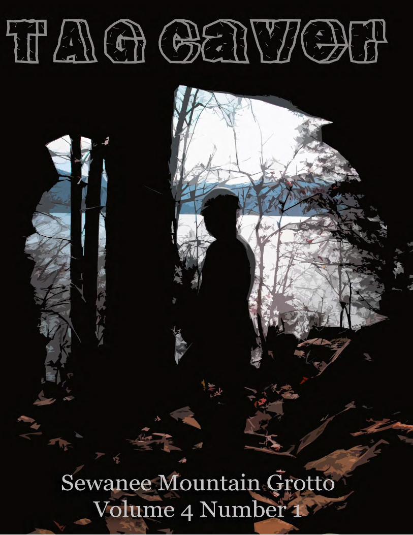
TAG Caver ~ Volume 4 Issue 1 Spring 2013
TAG Caver is the official newsletter of the
Sewanee Mountain Grotto & is published on a
quarterly basis. Sewanee Mountain Grotto is a
non- profit internal organization of the
National Speleological Society dedicated to the
exploration, mapping and conservation of
caves. If you are interested in joining the
Sewanee Mountain Grotto we invite you to
attend one of our monthly grotto meetings.
Meetings are held the second Saturday of each
month at various locations in the heart of TAG.
A typical meeting starts with a potluck dinner
at 6pm CST, followed by the meeting at 7pm.
On occasion we also have special presentations
following our meetings. Annual dues are $10
per person and are due in January. Please
email [email protected] or
one of our editors for more information on the
location of our next meeting. You may also visit
our website at
http://www.caves.org/grotto/sewaneemountai
ngrotto/
2012 Sewanee Mtn Grotto Officers:
Chairperson: Kelly Smallwood
Vice Chair & Programs: Woody Woods
Treasurer: Blaine Grindle
Secretary: Bambi Dunlap
Member at Large: Maureen Handler
Conservation Chair: Maureen Handler
Webmaster: Tina O’Hailey
TAG Caver Editors:
Kelly Smallwood
Jason Hardy
Email articles and photos for submissions to
one of our editors. Content may include
articles/photos from non members as well as
other caving regions. Statements and opinions
expressed in the TAG Caver do not necessarily
reflect the policies or beliefs of the Sewanee
Mountain Grotto or the NSS.
Front Cover: Caving Close to home near Lake Nickajack
Photo by Kelly Smallwood
Back Cover: Survey Photos in 2012 by
Kelly Smallwood
March 16th, 2013 – SKTF Cleanup at Cumberland Gap Quarry. For more
information and directions contact Cheryl Pratt, [email protected].
April 6th, 2013 – Spring Tennessee Cave Survey Meeting at Sewanee
University of the South. Meeting starts at 9am central in the Blackman
Auditorium. For more information email Chuck Sutherland,
April 13 – Alabama Cave Survey Meeting at the Scottsboro Public Library. Meeting time 9am central.
April 13 – Sewanee Mountain Grotto meeting. Hosted by Leslie Lytle in Tracy City, TN. Meeting starts at 6pm
central with a potluck dinner, followed by the business at 7pm.
April 14 – Sewanee Mountain Grotto trip to Steward Springs Cave in Fort Payne, AL. Contact Kelly for details.
May 11 – Sewanee Mountain Grotto meeting. Hosted by Bambi Dunlap in Monteagle, TN. Meeting starts at 6pm
central with a potluck dinner, followed by the business at 7pm.
May 24-27 – 42nd Kenctucky Speleofest hosted by the Louisville Grotto. Held at Lonestar Preserve.
June 13-16 – SERA Summer Cave Carnival, hosted by the Central Alabama Grotto. Event will be held at
Cumberland Caverns in Tennessee.
5BUConnect with the Grotto If you’re new to the Grotto, here are a few ways you can get to
know other members:
Join us on a Grotto Trip, Survey Trip or a Cleanup.
Sewanee Mountain Remailer
After you have joined the grotto, join our mailing list to keep up to date with cave trips and meetings.
Go to: http://sports.groups.yahoo.com/group/sewanee_mountain_grotto and click join. Please provide your
real name so we’ll know who you are.
Facebook – Join our official unofficial Facebook Page to meet other area cavers and
plan trips. Search for Sewanee Mountain Grotto under groups.
Support the Grotto ~ Grotto Merchandise The Grotto has Baseball Hats for $15 and 3’ patches for $5. Both items feature our grotto
logo. Please contact Kelly Smallwood at [email protected] to purchase.
Calendar of Upcoming Events
THE TAG SCOOP
The Sewanee Mountain Grotto now has 102
members..! If you have not paid your dues for 2013
please get them to Blaine Grindle ASAP. Your grace period ends in March.
You can download an updated membership list from the Yahoo group.
Membership dues are $10. You can pay Blaine at a meeting or send him a
check via snail mail. Please make checks payable to Sewanee Mountain
Grotto, c/o Blaine Grindle, 669 Old Sewanee Road, Sewanee, TN
37375. Make sure to include your contact information (name, address,
phone #, email address, & NSS #.
In 2012, the Grotto sent
out 72 Christmas Cards to
Landowners within the
TAG Region.
A Christmas Card the Grotto
Received from PMI
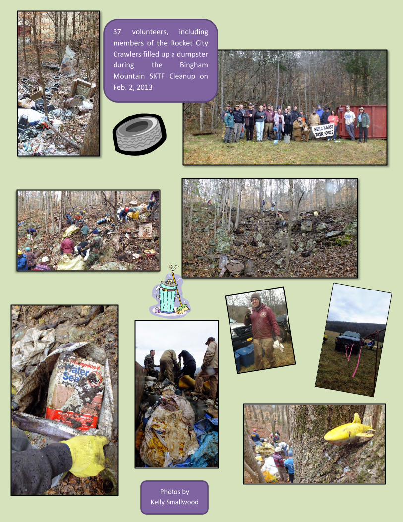
37 volunteers, including
members of the Rocket City
Crawlers filled up a dumpster
during the Bingham
Mountain SKTF Cleanup on
Feb. 2, 2013
Photos by
Kelly Smallwood
Twin Lakes Conservation Task Force Volunteers Keep
Busy in Kentucky by Jon
Durall
The Twin Lakes Cave Conservation and Survey Task
Force have had a busy few months since becoming an
official NSS Conservation Task Force in September
2012.
Twin Lakes CTF volunteers have participated in a
number of conservation projects including Army Corps
of Engineers Cave Creek Cave Conservation Project and
the Lost River Cave Conservation Project, which
included the removal of 275-315 kilograms (600-700
pounds) of trash and debris.
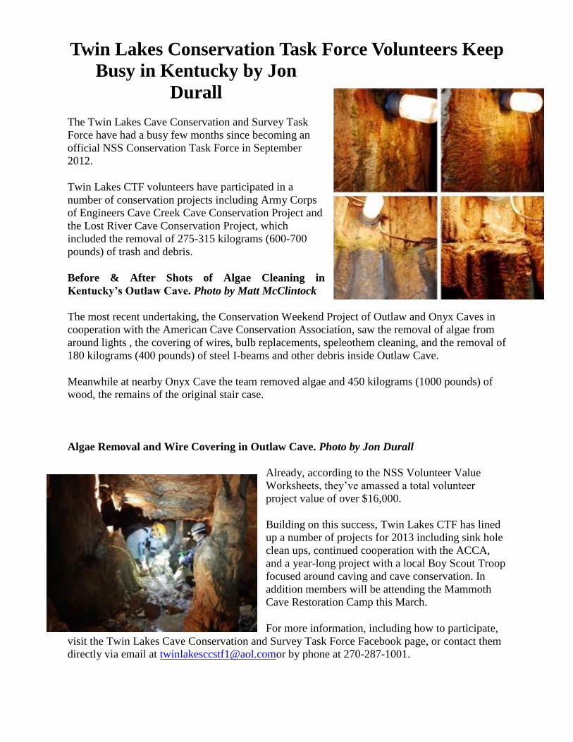
Before & After Shots of Algae Cleaning in
Kentucky’s Outlaw Cave. Photo by Matt McClintock
The most recent undertaking, the Conservation Weekend Project of Outlaw and Onyx Caves in
cooperation with the American Cave Conservation Association, saw the removal of algae from
around lights , the covering of wires, bulb replacements, speleothem cleaning, and the removal of
180 kilograms (400 pounds) of steel I-beams and other debris inside Outlaw Cave.
Meanwhile at nearby Onyx Cave the team removed algae and 450 kilograms (1000 pounds) of
wood, the remains of the original stair case.
Algae Removal and Wire Covering in Outlaw Cave. Photo by Jon Durall
Already, according to the NSS Volunteer Value
Worksheets, they’ve amassed a total volunteer
project value of over $16,000.
Building on this success, Twin Lakes CTF has lined
up a number of projects for 2013 including sink hole
clean ups, continued cooperation with the ACCA,
and a year-long project with a local Boy Scout Troop
focused around caving and cave conservation. In
addition members will be attending the Mammoth
Cave Restoration Camp this March.
For more information, including how to participate,
visit the Twin Lakes Cave Conservation and Survey Task Force Facebook page, or contact them
directly via email at [email protected] by phone at 270-287-1001.

Compiled by
Kelly Smallwood
I recently asked on the
NSS facebook page, “If
you could share a tip of
anything you’ve learned
while caving, it would
be…”
Donald Ingle: Always look back
the way you came, because
that’s what you’ll be looking at
when you’re finding your way
back out.
Andy Armstrong: Caves
are not dangerous until
you forget they are.
Dean Wiseman:
Never fully trust a
cave map.
Phil Winkler:
Ensure your rack is
rigged in correctly
BEFORE stepping
out over the pit.
Nancy Aulenbach: Don't
hold off needing to pee.
Relieving yourself will
instantly make your body
warmer and you'll be a
happier caver! Bring a pee
bottle in your pack that
you've practiced using in
the shower beforehand. Tevis Kouts: caver
time is not the
same as the true
time
Tray Heinke: If it's
a rock, it will fall...
unless you want it to
Bill Copeland When
someone tells you "oh
it's not that long of a
crawl" pack 2 extra
meals
Jim NichollsAlways
check you batteries
before you find yourself
at the back of the cave,
last in line, on the way
out !
Andy Witt: When 10 people
guarantee a sometimes sumped
passage will be dry, plan on
getting really wet.
Chad McCain Stay
the hell out of low air
Mud Hancock: The best kept
secrets are the ones everyone
knows about.
Bonny Armstrong:
Whenever you get on rope,
have the right gear to change
direction at a moments
notice.
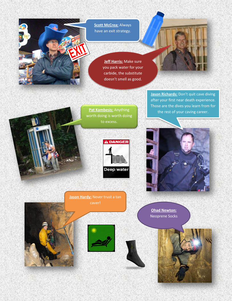
Scott McCrea: Always
have an exit strategy.
Jeff Harris: Make sure
you pack water for your
carbide, the substitute
doesn’t smell as good.
Pat Kambesis: Anything
worth doing is worth doing
to excess.
Jason Richards: Don’t quit cave diving
after your first near death experience.
Those are the dives you learn from for
the rest of your caving career.
Jason Hardy: Never trust a tan
caver!
Ohad Newton:
Neoprene Socks
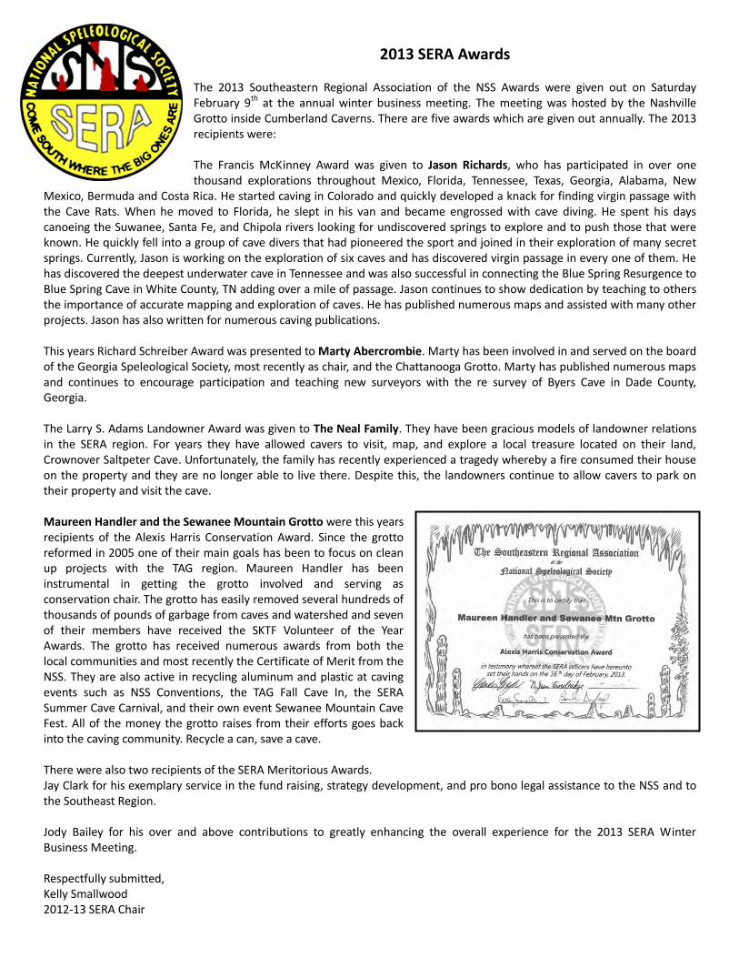
2013 SERA Awards The 2013 Southeastern Regional Association of the NSS Awards were given out on Saturday February 9th at the annual winter business meeting. The meeting was hosted by the Nashville Grotto inside Cumberland Caverns. There are five awards which are given out annually. The 2013 recipients were: The Francis McKinney Award was given to Jason Richards, who has participated in over one thousand explorations throughout Mexico, Florida, Tennessee, Texas, Georgia, Alabama, New
Mexico, Bermuda and Costa Rica. He started caving in Colorado and quickly developed a knack for finding virgin passage with the Cave Rats. When he moved to Florida, he slept in his van and became engrossed with cave diving. He spent his days canoeing the Suwanee, Santa Fe, and Chipola rivers looking for undiscovered springs to explore and to push those that were known. He quickly fell into a group of cave divers that had pioneered the sport and joined in their exploration of many secret springs. Currently, Jason is working on the exploration of six caves and has discovered virgin passage in every one of them. He has discovered the deepest underwater cave in Tennessee and was also successful in connecting the Blue Spring Resurgence to Blue Spring Cave in White County, TN adding over a mile of passage. Jason continues to show dedication by teaching to others the importance of accurate mapping and exploration of caves. He has published numerous maps and assisted with many other projects. Jason has also written for numerous caving publications. This years Richard Schreiber Award was presented to Marty Abercrombie. Marty has been involved in and served on the board of the Georgia Speleological Society, most recently as chair, and the Chattanooga Grotto. Marty has published numerous maps and continues to encourage participation and teaching new surveyors with the re survey of Byers Cave in Dade County, Georgia. The Larry S. Adams Landowner Award was given to The Neal Family. They have been gracious models of landowner relations in the SERA region. For years they have allowed cavers to visit, map, and explore a local treasure located on their land, Crownover Saltpeter Cave. Unfortunately, the family has recently experienced a tragedy whereby a fire consumed their house on the property and they are no longer able to live there. Despite this, the landowners continue to allow cavers to park on their property and visit the cave. Maureen Handler and the Sewanee Mountain Grotto were this years recipients of the Alexis Harris Conservation Award. Since the grotto reformed in 2005 one of their main goals has been to focus on clean up projects with the TAG region. Maureen Handler has been instrumental in getting the grotto involved and serving as conservation chair. The grotto has easily removed several hundreds of thousands of pounds of garbage from caves and watershed and seven of their members have received the SKTF Volunteer of the Year Awards. The grotto has received numerous awards from both the local communities and most recently the Certificate of Merit from the NSS. They are also active in recycling aluminum and plastic at caving events such as NSS Conventions, the TAG Fall Cave In, the SERA Summer Cave Carnival, and their own event Sewanee Mountain Cave Fest. All of the money the grotto raises from their efforts goes back into the caving community. Recycle a can, save a cave. There were also two recipients of the SERA Meritorious Awards. Jay Clark for his exemplary service in the fund raising, strategy development, and pro bono legal assistance to the NSS and to the Southeast Region. Jody Bailey for his over and above contributions to greatly enhancing the overall experience for the 2013 SERA Winter Business Meeting. Respectfully submitted, Kelly Smallwood 2012-13 SERA Chair
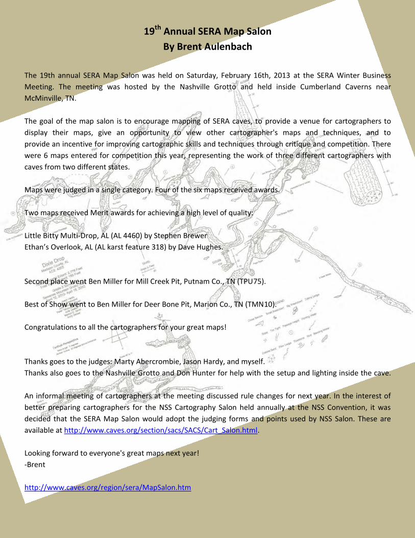
19th Annual SERA Map Salon
By Brent Aulenbach
The 19th annual SERA Map Salon was held on Saturday, February 16th, 2013 at the SERA Winter Business
Meeting. The meeting was hosted by the Nashville Grotto and held inside Cumberland Caverns near
McMinville, TN.
The goal of the map salon is to encourage mapping of SERA caves, to provide a venue for cartographers to
display their maps, give an opportunity to view other cartographer's maps and techniques, and to
provide an incentive for improving cartographic skills and techniques through critique and competition. There
were 6 maps entered for competition this year, representing the work of three different cartographers with
caves from two different states.
Maps were judged in a single category. Four of the six maps received awards.
Two maps received Merit awards for achieving a high level of quality:
Little Bitty Multi-Drop, AL (AL 4460) by Stephen Brewer
Ethan’s Overlook, AL (AL karst feature 318) by Dave Hughes.
Second place went Ben Miller for Mill Creek Pit, Putnam Co., TN (TPU75).
Best of Show went to Ben Miller for Deer Bone Pit, Marion Co., TN (TMN10).
Congratulations to all the cartographers for your great maps!
Thanks goes to the judges: Marty Abercrombie, Jason Hardy, and myself.
Thanks also goes to the Nashville Grotto and Don Hunter for help with the setup and lighting inside the cave.
An informal meeting of cartographers at the meeting discussed rule changes for next year. In the interest of
better preparing cartographers for the NSS Cartography Salon held annually at the NSS Convention, it was
decided that the SERA Map Salon would adopt the judging forms and points used by NSS Salon. These are
available at http://www.caves.org/section/sacs/SACS/Cart_Salon.html.
Looking forward to everyone's great maps next year!
-Brent
http://www.caves.org/region/sera/MapSalon.htm
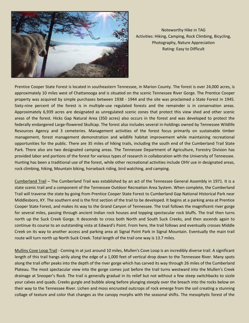
Noteworthy Hike in TAG
Activities: Hiking, Camping, Rock Climbing, Bicycling,
Photography, Nature Appreciation
Rating: Easy to Difficult
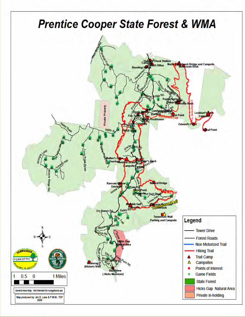
Prentice Cooper State Forest is located in southeastern Tennessee, in Marion County. The forest is over 24,000 acres, is
approximately 10 miles west of Chattanooga and is situated on the scenic Tennessee River Gorge. The Prentice Cooper
property was acquired by simple purchases between 1938 - 1944 and the site was proclaimed a State Forest in 1945.
Sixty-nine percent of the forest is in multiple-use regulated forests and the remainder is in conservation areas.
Approximately 6,939 acres are designated as unregulated scenic zones that protect this view shed and other scenic
areas of the forest. Hicks Gap Natural Area (350 acres) also occurs in the forest and was developed to protect the
federally endangered Large-flowered Skullcap. The forest also includes several in-holdings owned by Tennessee Wildlife
Resources Agency and 3 cemeteries. Management activities of the forest focus primarily on sustainable timber
management, forest management demonstration and wildlife habitat improvement while maintaining recreational
opportunities for the public. There are 35 miles of hiking trails, including the south end of the Cumberland Trail State
Park. There also are two designated camping areas. The Tennessee Department of Agriculture, Forestry Division has
provided labor and portions of the forest for various types of research in collaboration with the University of Tennessee.
Hunting has been a traditional use of the forest, while other recreational activities include OHV use in designated areas,
rock climbing, hiking, Mountain biking, horseback riding, bird watching, and camping.
Cumberland Trail – The Cumberland Trail was established by an act of the Tennessee General Assembly in 1971. It is a
state scenic trail and a component of the Tennessee Outdoor Recreation Area System. When complete, the Cumberland
Trail will traverse the state by going from Prentice Cooper State Forest to Cumberland Gap National Historical Park near
Middlesboro, KY. The southern end is the first section of the trail to be developed. It begins at a parking area at Prentice
Cooper State Forest, and makes its way to the Grand Canyon of Tennessee. The trail follows the magnificent river gorge
for several miles, passing through ancient Indian rock houses and topping spectacular rock bluffs. The trail then turns
north up the Suck Creek Gorge. It descends to cross both North and South Suck Creeks, and then ascends again to
continue its course to an outstanding vista at Edward’s Point. From here, the trail follows and eventually crosses Middle
Creek on its way to another access and parking area at Signal Point Park in Signal Mountain. Eventually the main trail
route will turn north up North Suck Creek. Total length of the trail one way is 13.7 miles.
Mullins Cove Loop Trail - Coming in at just around 10 miles, Mullen's Cove Loop is an incredibly diverse trail. A significant
length of this trail hangs airily along the edge of a 1,000 feet of vertical drop down to the Tennessee River. Many spots
along the trail offer peaks into the depth of the river gorge which has carved its way through 26 miles of the Cumberland
Plateau. The most spectacular view into the gorge comes just before the trail turns westward into the Mullen’s Creek
drainage at Snooper’s Rock. The trail is generally gradual in its relief but not without a few steep switchbacks to sizzle
your calves and quads. Creeks gurgle and bubble along before plunging steeply over the breach into the rocks below on
their way to the Tennessee River. Lichen and moss encrusted outcrops of rock emerge from the soil creating a stunning
collage of texture and color that changes as the canopy morphs with the seasonal shifts. The mesophytic forest of the
Cumberland Plateau is home to a great diversity of trees. Some of the more dominant tree species include: American
Beech, Yellow poplar, Hickory, Eastern Hemlock, Loblolly Pine, and many varieties of Oak.
Pot Point Loop – This 11.9 mile loop offers grand views of the Tennessee River Gorge and takes you over a large natural
bridge. There is a view of Raccoon Mountain across the river gorge and Ransom Hollow overlook is one of the best
views in the region. Along the trail camping is available at McNabb Gulf campsite and Hemlock Branch campsite.
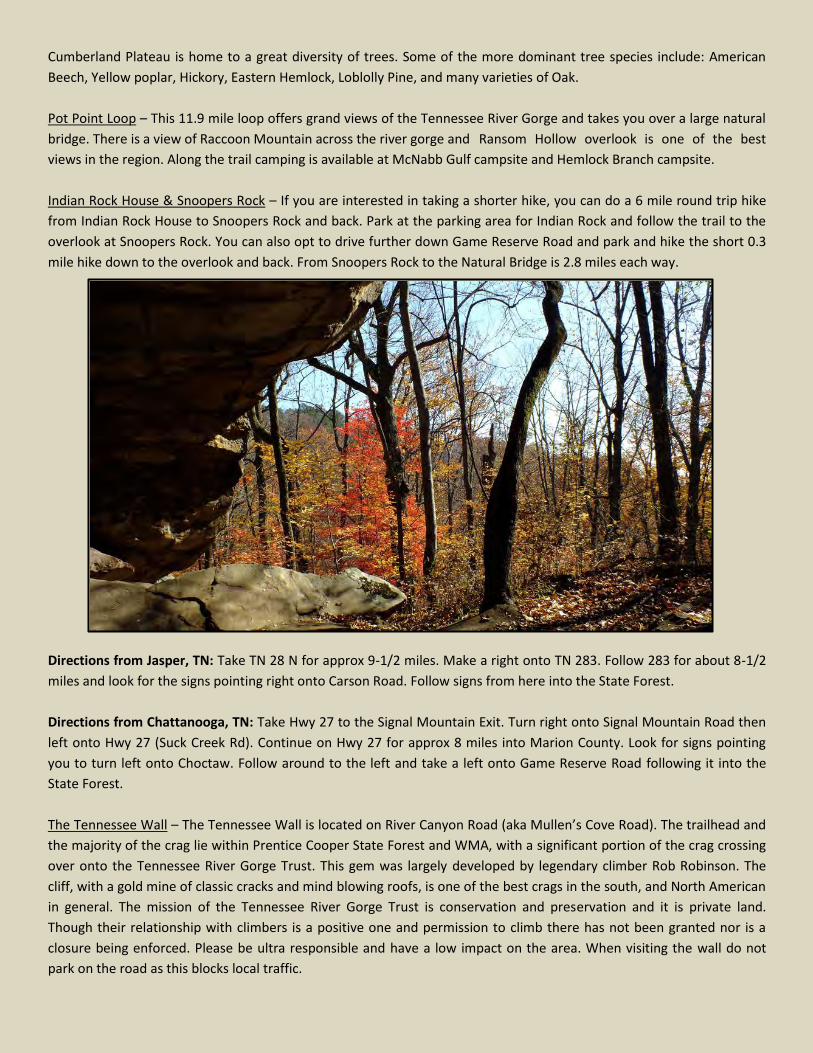
Indian Rock House & Snoopers Rock – If you are interested in taking a shorter hike, you can do a 6 mile round trip hike
from Indian Rock House to Snoopers Rock and back. Park at the parking area for Indian Rock and follow the trail to the
overlook at Snoopers Rock. You can also opt to drive further down Game Reserve Road and park and hike the short 0.3
mile hike down to the overlook and back. From Snoopers Rock to the Natural Bridge is 2.8 miles each way.
Directions from Jasper, TN: Take TN 28 N for approx 9-1/2 miles. Make a right onto TN 283. Follow 283 for about 8-1/2
miles and look for the signs pointing right onto Carson Road. Follow signs from here into the State Forest.
Directions from Chattanooga, TN: Take Hwy 27 to the Signal Mountain Exit. Turn right onto Signal Mountain Road then
left onto Hwy 27 (Suck Creek Rd). Continue on Hwy 27 for approx 8 miles into Marion County. Look for signs pointing
you to turn left onto Choctaw. Follow around to the left and take a left onto Game Reserve Road following it into the
State Forest.
The Tennessee Wall – The Tennessee Wall is located on River Canyon Road (aka Mullen’s Cove Road). The trailhead and
the majority of the crag lie within Prentice Cooper State Forest and WMA, with a significant portion of the crag crossing
over onto the Tennessee River Gorge Trust. This gem was largely developed by legendary climber Rob Robinson. The
cliff, with a gold mine of classic cracks and mind blowing roofs, is one of the best crags in the south, and North American
in general. The mission of the Tennessee River Gorge Trust is conservation and preservation and it is private land.
Though their relationship with climbers is a positive one and permission to climb there has not been granted nor is a
closure being enforced. Please be ultra responsible and have a low impact on the area. When visiting the wall do not
park on the road as this blocks local traffic.
The Prentice Cooper Climbing Management Guidelines specifically state that a permit is required to install bolts and
other fixed anchors in Prentice Cooper. Any unauthorized bolting is considered vandalism and jeopardizes the good
relationship that climbers have developed with the Forestry Division. Camping is available near the parking lot for the
wall but it is limited and is not an officially recognized campsite by the Forest. Camping on the north side of the road is
prohibited. Please not climbing is NOT allowed at Indian Rock House, Snoopers Rock or the Bluff view at the end of
Tower Road.
Seasonal Closures: If you are visiting during hunting season, please make sure to check the Prentice Cooper web site for
scheduled hunts before your visit. Also some areas are closed from late April through early July to encourage turkey
nesting. Turkeys do not like to be disturbed during the nesting period; therefore some areas are closed to motorized
vehicles during this time. Areas closed include: Tower Drive south of Pot Point Road, Elder Point, Long Point and Inman
Point. During the winter months the side roads are closed during periods of wet weather. Winter months bring a lot of
rain and snow along with freezing and thawing. These conditions make the dirt roads soft and muddy and susceptible to
damage, rutting, and erosion problems.
http://www.tn.gov/agriculture/forestry/stateforest07.shtml
Prentice Cooper State Forest Trail Mileage
Cumberland Trail
Parking area to Poplar Springs Campsite 3.3 mi.
Poplar Springs Campsite to Hwy 27 2.3 mi.
Hwy 27 to North Suck Creek 1.4 mi.
North Suck Creek to Edwards Point 2.7 mi.
Edwards Point to Signal Point 2.7 mi.
Total 13.7 mi.
Mullens Creek Loop Trail
Parking area to Indian Rock House 0.7 mi.
Indian Rock House to Snoopers Rock 2.7 mi.
Snoopers Rock to Hemlock Branch Campsite 1.1 mi.
Hemlock Branch to Mullen’s Cove overlook 0.3 mi.
Mullen’s Cove Overlook to Haley Road 2.2 mi.
Haley Road to Parking area 3.2 mi.
Total 10.2 mi.
Pot Point Loop Trail
Snoopers Rock to Natural Bridge 2.8 mi.
Natural Bridge to Pot Point Road 2.1 mi.
Pot Point Rd To Raccoon Mtn Overlook 1.5 mi.
Raccoon Mtn. Overlook to McNabb Gulf Camp 1.8 mi.
McNabb Gulf Camp to Tower Drive 0.7 mi.
Tower Dr. to Ransom Hollow Overlook 0.8 mi.
Ransom Hollow to Trail Jctn at Hemlock Branch 1.3 mi.
Trail Junction to Tower Drive 0.6 mi.
Tower Drive to Snoopers Rock 0.3 mi.
Total 11.9 mi.
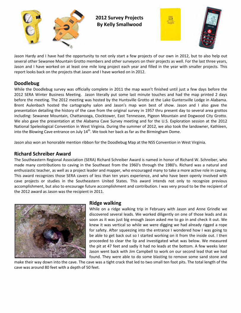
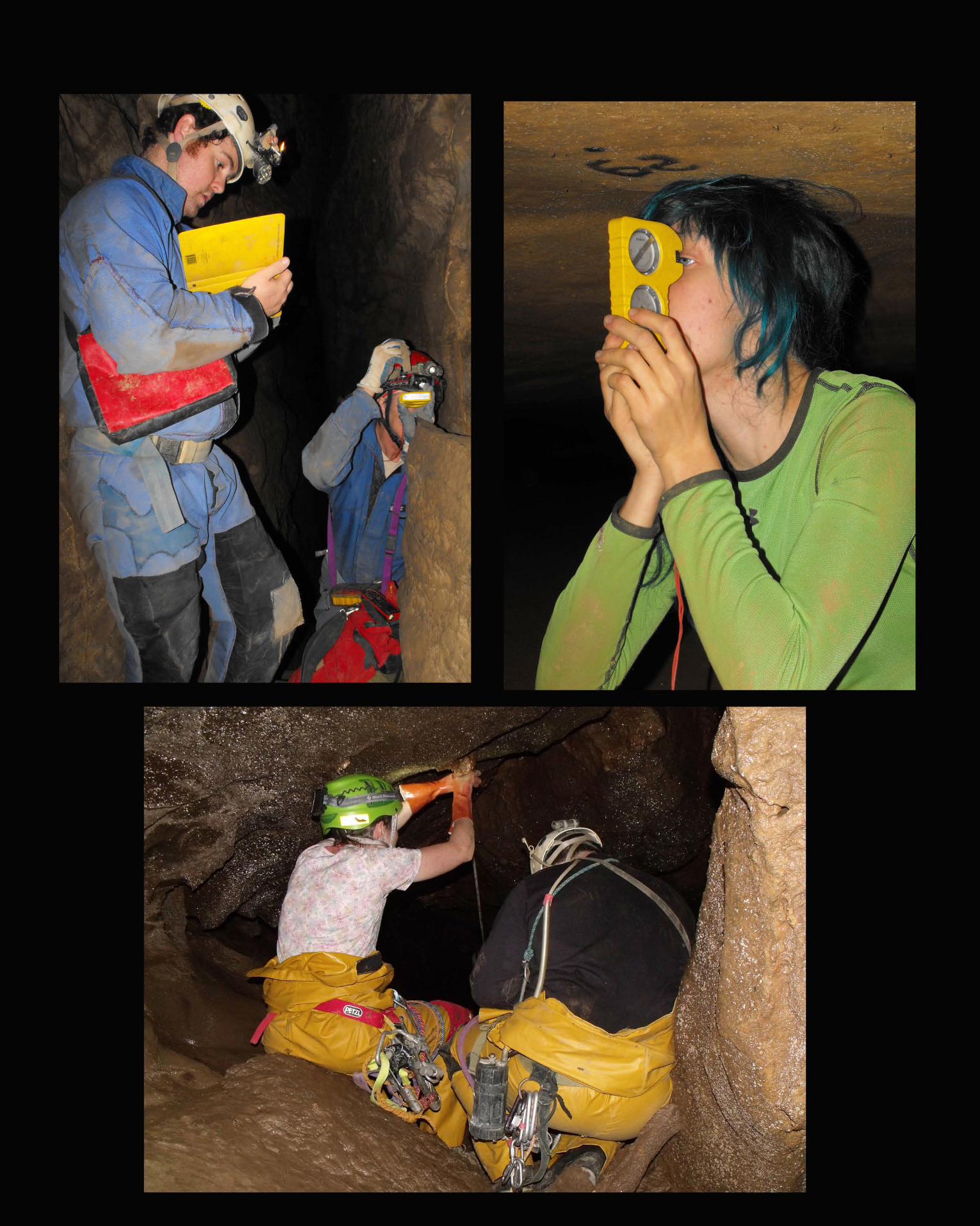
2012 Survey Projects By Kelly Smallwood
Jason Hardy and I have had the opportunity to not only start a few projects of our own in 2012, but to also help out several other Sewanee Mountain Grotto members and other surveyors on their projects as well. For the last three years, Jason and I have worked on at least one mile long project each year and filled in the year with smaller projects. This report looks back on the projects that Jason and I have worked on in 2012.
Doodlebug While the Doodlebug survey was officially complete in 2011 the map wasn’t finished until just a few days before the 2012 SERA Winter Business Meeting. Jason literally put some last minute touches and had the map printed 2 days before the meeting. The 2012 meeting was hosted by the Huntsville Grotto at the Lake Guntersville Lodge in Alabama. Brent Aulenbach hosted the cartography salon and Jason’s map won best of show. Jason and I also gave the presentation detailing the history of the cave from the original survey in 1957 thru present day to several area grottos including: Sewanee Mountain, Chattanooga, Clocktower, East Tennessee, Pigeon Mountain and Dogwood City Grotto. We also gave the presentation at the Alabama Cave Survey meeting and for the U.S. Exploration session at the 2012 National Speleological Convention in West Virginia. During the summer of 2012, we also took the landowner, Kathleen, into the Blowing Cave entrance on July 14th. We took her back as far as the Birmingham Dome. Jason also won an honorable mention ribbon for the Doodlebug Map at the NSS Convention in West Virginia.
Richard Schreiber Award The Southeastern Regional Association (SERA) Richard Schreiber Award is named in honor of Richard W. Schreiber, who made many contributions to caving in the Southeast from the 1960's through the 1980's. Richard was a natural and enthusiastic teacher, as well as a project leader and mapper, who encouraged many to take a more active role in caving. This award recognizes those SERA cavers of less than ten years experience, and who have been openly involved with cave projects or studies in the Southeastern United States. This award intends not only to recognize previous accomplishment, but also to encourage future accomplishment and contribution. I was very proud to be the recipient of the 2012 award as Jason was the recipient in 2011.
Ridge walking While on a ridge walking trip in February with Jason and Anne Grindle we discovered several leads. We worked diligently on one of those leads and as soon as it was just big enough Jason asked me to go in and check it out. We knew it was vertical so while we were digging we had already rigged a rope for safety. After squeezing into the entrance I wondered how I was going to be able to get back out so I started working on it from the inside out. I then proceeded to clear the lip and investigated what was below. We measured the pit at 47 feet and sadly it had no leads at the bottom. A few weeks later Jason went back with Jim Campbell to work on our second lead that we had found. They were able to do some blasting to remove some sand stone and
make their way down into the cave. The cave was a tight crack that led to two small ten foot pits. The total length of the cave was around 80 feet with a depth of 50 feet.
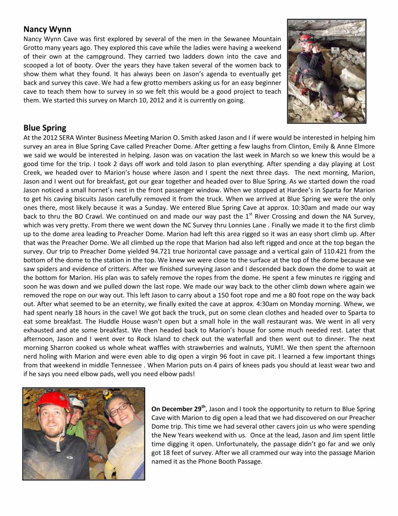
Nancy Wynn Nancy Wynn Cave was first explored by several of the men in the Sewanee Mountain Grotto many years ago. They explored this cave while the ladies were having a weekend of their own at the campground. They carried two ladders down into the cave and scooped a lot of booty. Over the years they have taken several of the women back to show them what they found. It has always been on Jason’s agenda to eventually get back and survey this cave. We had a few grotto members asking us for an easy beginner cave to teach them how to survey in so we felt this would be a good project to teach them. We started this survey on March 10, 2012 and it is currently on going.
Blue Spring At the 2012 SERA Winter Business Meeting Marion O. Smith asked Jason and I if were would be interested in helping him survey an area in Blue Spring Cave called Preacher Dome. After getting a few laughs from Clinton, Emily & Anne Elmore we said we would be interested in helping. Jason was on vacation the last week in March so we knew this would be a good time for the trip. I took 2 days off work and told Jason to plan everything. After spending a day playing at Lost Creek, we headed over to Marion’s house where Jason and I spent the next three days. The next morning, Marion, Jason and I went out for breakfast, got our gear together and headed over to Blue Spring. As we started down the road Jason noticed a small hornet’s nest in the front passenger window. When we stopped at Hardee’s in Sparta for Marion to get his caving biscuits Jason carefully removed it from the truck. When we arrived at Blue Spring we were the only ones there, most likely because it was a Sunday. We entered Blue Spring Cave at approx. 10:30am and made our way back to thru the BO Crawl. We continued on and made our way past the 1st River Crossing and down the NA Survey, which was very pretty. From there we went down the NC Survey thru Lonnies Lane . Finally we made it to the first climb up to the dome area leading to Preacher Dome. Marion had left this area rigged so it was an easy short climb up. After that was the Preacher Dome. We all climbed up the rope that Marion had also left rigged and once at the top began the survey. Our trip to Preacher Dome yielded 94.721 true horizontal cave passage and a vertical gain of 110.421 from the bottom of the dome to the station in the top. We knew we were close to the surface at the top of the dome because we saw spiders and evidence of critters. After we finished surveying Jason and I descended back down the dome to wait at the bottom for Marion. His plan was to safely remove the ropes from the dome. He spent a few minutes re rigging and soon he was down and we pulled down the last rope. We made our way back to the other climb down where again we removed the rope on our way out. This left Jason to carry about a 150 foot rope and me a 80 foot rope on the way back out. After what seemed to be an eternity, we finally exited the cave at approx. 4:30am on Monday morning. Whew, we had spent nearly 18 hours in the cave! We got back the truck, put on some clean clothes and headed over to Sparta to eat some breakfast. The Huddle House wasn’t open but a small hole in the wall restaurant was. We went in all very exhausted and ate some breakfast. We then headed back to Marion’s house for some much needed rest. Later that afternoon, Jason and I went over to Rock Island to check out the waterfall and then went out to dinner. The next morning Sharron cooked us whole wheat waffles with strawberries and walnuts, YUM!. We then spent the afternoon nerd holing with Marion and were even able to dig open a virgin 96 foot in cave pit. I learned a few important things from that weekend in middle Tennessee . When Marion puts on 4 pairs of knees pads you should at least wear two and if he says you need elbow pads, well you need elbow pads!
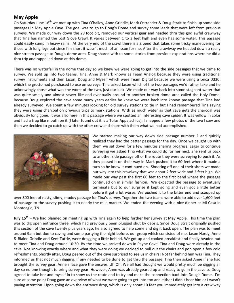
On December 29th, Jason and I took the opportunity to return to Blue Spring Cave with Marion to dig open a lead that we had discovered on our Preacher Dome trip. This time we had several other cavers join us who were spending the New Years weekend with us. Once at the lead, Jason and Jim spent little time digging it open. Unfortunately, the passage didn’t go far and we only got 18 feet of survey. After we all crammed our way into the passage Marion named it as the Phone Booth Passage.
May Apple On Saturday June 16th we met up with Tina O’hailey, Anne Grindle, Mark Ostrander & Doug Strait to finish up some side passages in May Apple Cave. The goal was to go to Doug’s Dome and survey some leads that were left from previous surveys. We made our way down the 29 foot pit, removed our vertical gear and headed thru this god awful crawlway that Tina has named the Lost Glove Crawl. It varies between 1 to 3 feet high and even has some water. This passage could easily sump in heavy rains. At the very end of the crawl there is a Z bend that takes some tricky maneuvering for those with long legs but since I’m short it wasn’t much of an issue for me. After the crawlway we headed down a really nice stream passage to Doug’s dome area. Doug shared with us some stories from previous explorations where he did a thru trip and rappelled down at this dome. There was no waterfall in the dome that day so we knew we were going to get into the side passages that we came to survey. We split up into two teams. Tina, Anne & Mark known as Team Analog because they were using traditional survey instruments and then Jason, Doug and Myself which were Team Digital because we were using a Leica D330, which the grotto had purchased to use on surveys. Tina asked Jason which of the two passages we’d rather take and he unknowingly chose what was the worst of the two, just our luck. We made our way back into some stagnant water that was quite smelly and almost sewer like and eventually around to another broken dome area called the Holy Dome. Because Doug explored the cave some many years earlier he knew we were back into known passage that Tina had already surveyed. We spent a few minutes looking for old survey stations to tie in but I had remembered Tina saying they were using charcoal on previous trips to mark stations. With as much water as that cave gets the charcoal was obviously long gone. It was also here in this passage where we spotted an interesting cave spider. It was yellow in color and had a trap like mouth on it (I later found out it is a Tolus Appalachius). I snapped a few photos of the two I saw and then we decided to go catch up with the other crew and share with them what we had accomplished.
We started making our way down side passage number 2 and quickly realized they had the better passage for the day. Once we caught up with them we sat down for a few minutes sharing progress. Eager to continue surveying we asked Tina what we could do for her next. She sent us back to another side passage off of the route they were surveying to push it. As they passed it on their way in Mark pushed it to 60 feet where it made a turn so he knew it continued on. Shooting off one of their shots we made our way into this crawlway that was about 2 feet wide and 2 feet high. We made our way past the first 60 feet to the first bend where the passage continued on in similar fashion. We expected the passage to eventually terminate but to our surprise it kept going and even got a little better before it got a lot worse. We pushed it to the bitter end and scooped up
over 800 feet of nasty, slimy, muddy passage for Tina’s survey. Together the two teams were able to add over 1,600 feet of passage to the survey pushing it to nearly the mile marker. We ended the evening with a nice dinner at Mi Casa in Monteagle, TN. July 15th – We had planned on meeting up with Tina again to help further her survey at May Apple. This time the plan was to dig open entrance three, which had previously been plugged shut by debris. Since Doug Strait originally pushed this section of the cave twenty plus years ago, he also agreed to help come and dig it back open. The plan was to meet around 9am but due to caving and some partying the night before, our group which consisted of me, Jason Hardy, Anne & Blaine Grindle and Kent Tuttle, were dragging a little behind. We got up and cooked breakfast and finally headed out to meet Tina and Doug around 10:30. By the time we arrived down in Payne Cove, Tina and Doug were already in the cave. Not knowing exactly where and what they were doing we decided to pull out the chairs and pop open a few cold refreshments. Shortly after, Doug peered out of the cave surprised to see us in chairs! Not far behind him was Tina. They informed us that not much digging, if any needed to be done to get thru the passage. Tina then asked Anne if she had brought the survey gear. Anne’s face gave the answer. Uh Oh. We all had thought we would pretty much be digging all day so no one thought to bring survey gear. However, Anne was already geared up and ready to go in the cave so Doug agreed to take her and myself in to show us the route and to try and make the connection back into Doug’s Dome. I’m sure at some point Doug gave an overview of what we were going to get into too and either I didn’t hear him or I wasn’t paying attention. Upon going down the entrance drop, which is only about 10 feet you immediately get into a crawlway
for about another 50 feet to the second drop. Doug had pre warned us about the rigging for the second drop, which was basically just a knot rig. Upon arriving at it, sure enough it was nothing like any rigging I had ever seen. However I trust Doug and knew the rigging would hold so we continued down the 20 feet of the second drop. Once at the bottom, you are again immediately in a crawlway with cobblestone and sand. This crawlway goes for about 400 feet until it eventually starts to open up to a stoop walk and then walking passage. We finally made our way thru a mazy passage way and popped out just above the Dome. We did it, we made the connection and then made our way out to tell the others of our progress. Tina was very excited. We spent a few minutes cleaning up and then packed up all our gear and headed back up to the mountain to play some Sunday Volleyball. Tina later reported that on November 11th, 2012 that she completed the Mayapple survey. The total cave length came to a horizontal length of 6,215.5 feet and a vertical depth of 154.6 feet.
Pryor Spring Sunday morning June 17th, myself, Jason, Marissa Lasso & Wade Waltman met up with Marty Abercrombie and Will Urbanski to finish up the survey at Pryor Springs Cave. Jason and I were also very excited about this trip because we had never been there before and it was within 15 minutes of our house. After obtaining permission from the landowner we made our way up and entered the cave at the upper entrance. Not only was this Marissa & Wade’s first survey but it was also their first multi drop and pull down. Marty rigged a safety line for us to make it down to the entrance pit where Jason and Will rigged it. For pull downs we use a clove hitch as a beaner block but also put an extra figure 8 and carabiner as a back up so there would be no mistake on which side of the rope to rappel on. Another thing we do for safety is we do not drop the other end of the rope until the last person rappels. After the first drop Marty showed
us a dome area that needed surveying so we split up into two teams. Jason, myself, and Marissa took this area to survey and were to then meet the rest of the crew beyond the second drop. Upon completion we made our way down a small nuisance drop that has an old rope as hand line. From here you are almost immediately at the second drop. WOW, what a nice drop it is too. It had a little water flow so it made for a nice refreshing drop. This was also Marissa’s first experience rappelling in any water. From here we caught up with the rest of the crew surveying another side passage. Marty wasn’t joking when he told me he didn’t have much left to do because when we found them they only had one more shot left. After spending a few minutes in this area we all then made our way to the third and final drop. This drop is also quite nice and drops into a dome area with a giant pool of water at the bottom. We then made our way out the last 1,000 feet of nice, strolling stream passage passing lots of pretties and historical signatures from the late 1890’s.
Project YETI Hole On July 9, 1994 Mike Thomas, along with Lin Guy and Glenda Fleming made their way down into a cove in Alabama to check out some leads. Some hunters had told Mike about some caves, so they went to take a look. They took Lin’s 1985 Jeep CJ-7 down the old logging road to a spot near the junction with the creek. They parked here, unknowingly unleashing a nest of yellow jackets in the road. They walked south and came upon a tree with the word cave carved in its trunk. Uphill they found a rock shelter like entrance blowing air, which they named and started mapping. After mapping 1190 feet they came to a slimy belly crawl. They decided to call it a day and head back over to Mike’s next lead. Upon going in the new lead they found a wooden ladder at the 14 foot entrance. At the foot of the ladder there was a large spool of twine, from which hundreds of feet were unraveled. They made their way down the passageway a few hundred feet into a wide gloomy gooey canyon with slimy sloping walls. Wearing a wheat lamp it looked hazardous to push without a safety line so they decided to turn back. They named the cave, turned in into the Alabama Cave Survey as 500 feet and never returned. After Steve T. Davis moved back to Alabama in 2010 he began exploring the caves in his neighborhood. Upon entering what we are presently calling Project Yeti Hole, he realized the cave is much bigger than what it is listed as in the ACS. He reached out to Lin who was not interested in going back so he then reached out to Jim Smith. Jim was also not interested so Steve reached out to Jason and I after seeing our presentation on the Doodlebug survey at the Alabama Cave Survey meeting. We agreed to check out the cave but told Steve if we were going to push the cave then we were going to start a survey and survey as we went.
July 8th - Jason, myself, Anne Grindle, Kim Smith, and Keith Sutphin met Steve at his home in Alabama. He along with his neighbor, Ken Williams led us down the 4x4 road to the valley floor to the entrance of the cave. The cave was blowing a lot of air and an equally impressive huge Buckeye Tree was also right next to the bluff at the entrance. Upon entering the cave we found that the ladder had been moved but the hundreds of feet of twine were still there. We rigged the 14 foot entrance drop and then began our survey. We were able to survey nearly 1,000 feet on this day but it wasn’t easy. There is a lot of mud and slippery slopes in this cave. Keeping with the theme of the cave, we decided to name the first passage in the cave The Highway to Hell. Standing there at our stopping point, we knew on the next trip we would have to do something to make the going passage safer for a survey team. We were facing a canyon with deep walls that we knew we were going to have to climb out of and onto the muddy slippery slopes above. Over the next week we decided we would need to bring back not only a crew to survey but a push team with shovels to dig foot holes for us to traverse through the tricky canyon passage.
July 21st – We woke up and started getting ready for our day. Jim and Rachel had come up the night before so we cooked some breakfast while we waited on the others to arrive. By the time they did it was literally pouring rain outside. Concerned about the weather and the condition of the road to the cave Jason checked the weather radar. After determining that it was just a pop up shower we were all very eager to get on the road and into the cave. This time we came armed with enough cavers to not only survey but to also have a team of diggers leading the way for the survey team. Joining us this time were Blaine Grindle, Jim & Rachel Campbell, Danja Mewes, Scott Ehardt, Kim Smith, Keith Sutphin, Jason and myself. We knew this was a lot but also knew that we needed all the help to progress the survey. Blaine, Jim & Keith led the way and we later dubbed them as the Fraggles. They dug safe passages with shovels thru the mud slopped walls and following behind was Jason leading the survey team. We taught Rachel how to read the laser while Danja did the compass and I taught Scott how to set stations. Along the way, we also named another passage Hell’s Half Acre. After a few hundred feet and past the last known footsteps in the cave we all finally sat down for a break and admired the amazing view before us. For the majority, this was the first time virgin borehole was witnessed. The best way I can describe it is like fresh snow. The passage was huge and the mud was so perfect with no footsteps in it at all. It was perfect and no man or woman had ever stepped foot in it before. We all felt very blessed to be a part of this project, admired it for a few minutes and then took some pictures. The digging team eagerly continued ahead of the survey team and eventually we began to hear water. We finally reached a canyon too wide or safe to traverse. We named this area Come Hell or High Water. There were a few small leads here that were also checked to look for a way down into the water. Jason knew at this point we had reached a major point in the cave and we would have to return to set bolts to continue on. We knew we had already had a good day of surveying nearly 1,000 feet so called it a day and started discussing plans to return. All very eager and excited, we determined that the very next day would be optimal and we all started carefully routing out. On the way back we stopped by Steve’s house to let him know our progress for the day. He was also very excited and wanted to return with us the next morning. Very excited about what we had found Jason decided to call Marion O. Smith. After informing Marion of our find, Jason was able to talk him into dropping all plans and coming down to help us the next morning.
July 22nd – We made plans to meet Marion at Big Daddy’s Fireworks at 9am, along with Keith and Kim. Jim, Rachel, Danja and Scott had all spent the evening with us so we got up early and cooked breakfast before leaving our house. Keith called and informed me that he was running late so I told him to just meet us at Steve’s house. Once at Steve’s we condensed vehicles and started our way back down the 4x4 road to the parking area for the cave. Just about the time we had geared up and started towards the cave Keith & Kim showed up. One by one we all made our way in, pass the nuisance 14 foot drop and thru the scary borehole with the crack in the middle. Jim carried the heaviest pack with the drill. Once at the stopping point from the previous day, Jason got all his gear ready to set some bolts. He made his way out onto the ledge and set 3 bolts, rigging the rope as he went. He then left it up to the digging team to progress us forward. After about 10 minutes of Jim trying to safely make his way across it was determined that we would have to rappel down into the canyon into the stream passage. Jason re rigged and then re set the rope for a rappel instead of a traverse. Jason took the lead and went down into the water passage. After spending a few minutes and determining this would be the way he called for the survey team to continue. At this point, Kim, Keith, Danja & Scott decided to call it a day and route. This left Jason, Marion, Jim, Rachel, Steve and myself. Marion wanted to pull tape and not use a disto so since we were in water I read instruments. We continued on upstream thru a small canyon and finally found some dry passage. After a few hundred more feet we were back in the water but this time it was a wider stream passage. Keeping with the theme we decided to name this passage The River Styx. We ended up surveying nearly 1,000 feet again and found a good stopping point for the day. While it’s hard, it’s also very rewarding to survey as you go. None of us wanted to leave not knowing what was around the next corner but knew it would continue the excitement for the next trip. We set up some flashes and snapped a picture of what was before us. Little did we know at the time, but this picture would taunt us for the next two weeks. August 4th – Jim & Rachel Campell, along with Shari Lydy drove up from the Atlanta area on Friday evening, August 3rd. Saturday morning we got up and cooked some breakfast and headed out to meet the rest of the crew for a long day of surveying. Once at Steve’s house, already waiting on us were Steve, Marion, Keith & Marty Abercrombie. The plan for the day was to have two teams – team 1 was Jason, Marion, Jim & Steve. They would pick up where we left off in the borehole beyond the drop last time. Team 2 was Marty, Shari & Keith. They would survey the leads near the entrance while Rachel and I took photos. On the way down to the cave we also decided that Rachel, Shari and I would pick up the aluminum cans that littered the 4x4 road the entire way down. This would also allow enough time for Jason and Marty’s team to get geared up and in the cave so we would not have a bottle neck of cavers waiting at the entrance. Jason was also going to set some more bolts for a traverse line in the canyon to make it safer for the crews to pass.
Shortly after starting our descent down the 4x4 road, Rachel and I began picking up the cans while Shari drove alongside us. A few minutes later, I heard Rachel shouting and as I looked back I realized that Shari had accidentally nearly driven over Rachel’s foot. As Rachel was yelling to move the vehicle, I quickly said to Shari, “Go in reverse”. Rachel was a little shaken but luckily nothing was broken. She was able to continue on so we forged ahead picking up cans. Once at the parking spot at the bottom, team 1 and 2 were nearly ready to head off into the cave. I gave Jason a kiss and told him I’d see him later. Shari, Rachel and I then geared up and started our way over to the entrance. Once there, we made our way in with Marty & Keith. By this time,
Jason and his team were long gone on their way to set the traverse line. I showed Marty where the first side lead was and he began his survey. Shari was setting point and Keith was reading instruments. Rachel and I followed along behind them snapping some photos. As we made our way into one room we noticed there were a lot of tiny roots growing out of the mud. Keeping with the theme of the cave, I said we should come up with a name for the room. Shari quickly shouted out, “The Root of All Evil” and we all liked it. As Rachel and I were waiting on the team to catch up I noticed a small side lead behind a pretty formation. I told Rachel she should go check it out and see if it goes anywhere for the team to survey. As she proceeded cautiously pass the formation she shouted back to me that she went at least 40 feet. When Marty caught up to where we were at with his team we showed him the lead. As the team started off to survey this lead, Rachel and I knew it was too small for all of us to go in so we decided to wait in the Root of All Evil room. Once they were finished we made our way around and eventually did a loop. We tied back in and then decided it was time for a break. We had spent nearly 4 hours surveying this one side passage. Since it was getting late and the first one had taken longer than expected, we decided to go ahead and make our way down to the rest of the cave and catch up to Jason’s team. Just as we were entering the first canyon area, out of nowhere Rachel took a big fall. As she was falling, to prevent herself from going into the canyon she flung her body onto the ledge. It was very scary to look back and see Rachel grabbing onto the slippery, muddy ledge while her legs were dangling below. Very quickly Keith and Marty
assisted her. Once she got safe and realized she was ok we continued on. I was very impressed when we got to the area where Jason had set a traverse line. This part of the cave had been a very scary part for those of us who had passed it many times with no safety line. It is a slippery slope that is above a canyon that is about 20 feet deep in some spots. One fall and you could be seriously injured so it was very nice to now have a safety line. One by one we made our way across and finally to the drop. As we headed down the stream passage we did notice there were several big side leads that Jason had left for Marty. Shortly after, we finally came upon Jason’s team as they were heading back towards us. Unfortunately, they had found the end of the cave. It was a big breakdown choke. But there was still more work to do. Very eager Marty told Jason he was willing to continue surveying so Jason showed him the first side lead. I still wanted to take more pictures so Jim, Rachel, Jason and I headed towards the end while Marty, Keith, Shari, Steve & Marion surveyed some of the side leads. As Jim and Jason showed Rachel and me the rest of the cave we set up some shots using three flashes along the way. Once we were finally at the end we were greeted by a huge breakdown choke that literally blocked the entire borehole passage. There is water flowing from underneath so hopefully with some more pushing on the next trip we can find a way around this. We took a few more pictures and then headed back to meet up with Marty’s team.
Once back with Marty’s team we found them still surveying one of the side passages. Jason decided that the 4 of us should go ahead and start making out way out of the cave. We decided to wait on them at the top of the drop. I was the last one to climb and just as I was nearing the top I could hear the others very close by. As we were waiting, Marion was the first from the second team to come up. Rachel, Marion and I decided to go ahead and finish making our way out of the cave while Jason and Jim waited on the others. When we reached the traverse line Marion said to me, “Do you want to carry this drill out?” I very proudly told Marion, “There are some things I feel are a mans job and one of those things is carrying the drill out of the cave!” As I neared the other side where Rachel was waiting I shouted back to Marion to let him know I was off the traverse line. As he was making his way across he was mumbling something about the drill. Rachel and I then realized he was carrying it across the traverse line. I shouted to Marion and told him that when I said it was a man’s job I didn’t intend for him to carry it. I expected one of the younger bucks that were behind us to get it. Once Marion was off the traverse line Rachel decided she would then carry it out. Just as we were back at the entrance Marion started looking for the bottle of water he stashed at the entrance. He wasn’t able to find it and I asked him what kind of bottle it was. He said it was a small bottle and just then I realized, uh oh.. Keith had gone off during our survey earlier because he had to pee. He said he was going to pee in one of the bottles near the entrance. So I pointed out to
Marion the bottle that Keith had peed in. Marion picked it up and gave it a good glare and said, “He peed in my bottle, what did he do with the water that was in it? I can’t believe he peed in my bottle.” Rachel and I started laughing hysterically, we just couldn’t help it. Marion was in such disbelief that someone disposed of his water to fill his bottle with their pee. About this time, Jason and Jim showed up and we shared with them what Marion had just discovered. They were also very thankful that we had brought the drill out for them as well. Once all 5 of us were out, we headed back the short distance to change and wait for the others. Finally everyone was out, we were all changed and ready to head back up the 4x4 road in the dark.
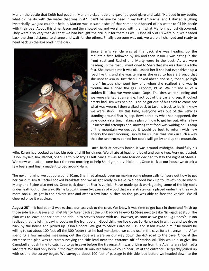
Since Shari’s vehicle was at the back she was heading up the mountain first, followed by Jim and then Jason. I was sitting in the front seat and Rachel and Marty were in the back. As we were heading up the road, I mentioned to Shari that she was driving a little fast. She assured me it was ok. I asked her if she had ever driven up a road like this and she was telling us she used to have a Bronco that she used to 4x4 in. Just then I looked ahead and said, “Shari, go high here.” Instead she went low and when she realized she was in trouble she gunned the gas. Kaboom, POW. We hit and all of a sudden like that we were stuck. Oops. The tires were spinning and we were slanted at an angle. I got out of the car and yep, it looked pretty bad. Jim was behind us so he got out of his truck to come see what was wrong. I then walked back to Jason’s truck to let him know we were stuck. By this time, everyone was out of the vehicles standing around Shari’s jeep. Bewildered by what had happened, the guys quickly starting making a plan on how to get her out. After a few unsuccessful attempts and knowing that food was waiting on us atop of the mountain we decided it would be best to return with new energy the next morning. Luckily for us Shari was stuck in such a way that the two trucks behind her could still get by and up the mountain. Once back at Steve’s house it was around midnight. Thankfully his
wife, Karen had cooked us two big pots of chili for dinner. We all ate at least one bowl and some two. Very exhausted, Jason, myself, Jim, Rachel, Shari, Keith & Marty all left. Since it was so late Marion decided to stay the night at Steve’s. We knew we had to come back the next morning to help Shari get her vehicle out. Once back at our house we drank a few beers and finally made it to bed around 4am. The next morning, we got up around 10am. Shari had already been up making some phone calls to figure out how to get her car out. Jim & Rachel cooked breakfast and we all got ready to leave. We headed back up to Steve’s house where Marty and Blaine also met us. Once back down at Shari’s vehicle, Steve made quick work getting some of the big rocks underneath out of the way. Blaine brought some 6x6 pieces of wood that were strategically placed under the tires with more rocks. Jim got in the drivers seat and after a few hard pushes on the gas was able to free the vehicle. We all cheered once it was clear. August 25th – It had been 3 weeks since our last visit to the cave. We knew it was time to get back in there and finish up those side leads. Jason and I met Nancy Aulenbach at the Big Daddy’s Fireworks Store next to Lake Nickajack at 8:30. The plan was to leave her car here and ride up to Steve’s house with us. However, as soon as we got to Big Daddy’s, Jason realized that he left his caving boots on the front porch. Good thing we live close. So Nancy got in with us and we drove back by the house and picked up Jason’s boots. We got to Steve’s around 9:15 and Jason asked him if he would be willing to cut about 100 foot off the 300 footer that he had mentioned we could use in the cave for a traverse line. After spending a few minutes measuring out the rope we were on our way down the 4x4 road to the cave. Once at the entrance the plan was to start surveying the side lead near the entrance off of station A6. This would also give Jim Campbell enough time to catch up to us in cave before the traverse. Jim was driving up from the Atlanta area but had a late start. We had only been in the cave about 30 minutes when we could hear Jim at the entrance. He quickly joined up with us and the survey began. We surveyed about 100 feet of passage in this side lead before we headed down to the
next one. The next lead was just before the drop into the water passage and we got about another 50 feet here. It was a slimy, muddy passage so Steve and I waited at the drop while Jim, Nancy, & Jason surveyed it. We then each made our way down the drop into the water passage. We decided that we would go check out a few other side leads further upstream before going downstream. We knew going downstream there was potential to get completely soaked so decided it would be best to save it for last.
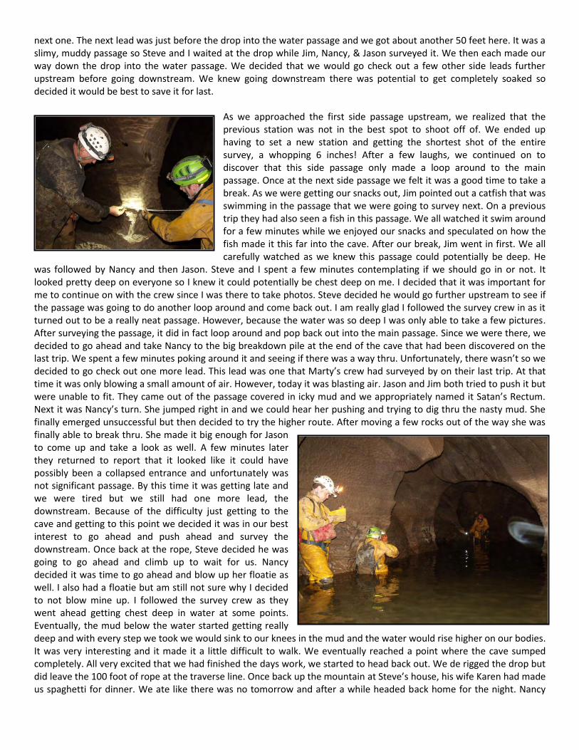
As we approached the first side passage upstream, we realized that the previous station was not in the best spot to shoot off of. We ended up having to set a new station and getting the shortest shot of the entire survey, a whopping 6 inches! After a few laughs, we continued on to discover that this side passage only made a loop around to the main passage. Once at the next side passage we felt it was a good time to take a break. As we were getting our snacks out, Jim pointed out a catfish that was swimming in the passage that we were going to survey next. On a previous trip they had also seen a fish in this passage. We all watched it swim around for a few minutes while we enjoyed our snacks and speculated on how the fish made it this far into the cave. After our break, Jim went in first. We all carefully watched as we knew this passage could potentially be deep. He
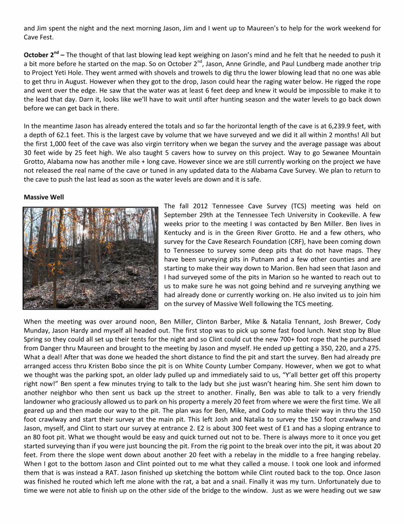
was followed by Nancy and then Jason. Steve and I spent a few minutes contemplating if we should go in or not. It looked pretty deep on everyone so I knew it could potentially be chest deep on me. I decided that it was important for me to continue on with the crew since I was there to take photos. Steve decided he would go further upstream to see if the passage was going to do another loop around and come back out. I am really glad I followed the survey crew in as it turned out to be a really neat passage. However, because the water was so deep I was only able to take a few pictures. After surveying the passage, it did in fact loop around and pop back out into the main passage. Since we were there, we decided to go ahead and take Nancy to the big breakdown pile at the end of the cave that had been discovered on the last trip. We spent a few minutes poking around it and seeing if there was a way thru. Unfortunately, there wasn’t so we decided to go check out one more lead. This lead was one that Marty’s crew had surveyed by on their last trip. At that time it was only blowing a small amount of air. However, today it was blasting air. Jason and Jim both tried to push it but were unable to fit. They came out of the passage covered in icky mud and we appropriately named it Satan’s Rectum. Next it was Nancy’s turn. She jumped right in and we could hear her pushing and trying to dig thru the nasty mud. She finally emerged unsuccessful but then decided to try the higher route. After moving a few rocks out of the way she was finally able to break thru. She made it big enough for Jason to come up and take a look as well. A few minutes later they returned to report that it looked like it could have possibly been a collapsed entrance and unfortunately was not significant passage. By this time it was getting late and we were tired but we still had one more lead, the downstream. Because of the difficulty just getting to the cave and getting to this point we decided it was in our best interest to go ahead and push ahead and survey the downstream. Once back at the rope, Steve decided he was going to go ahead and climb up to wait for us. Nancy decided it was time to go ahead and blow up her floatie as well. I also had a floatie but am still not sure why I decided to not blow mine up. I followed the survey crew as they went ahead getting chest deep in water at some points. Eventually, the mud below the water started getting really deep and with every step we took we would sink to our knees in the mud and the water would rise higher on our bodies. It was very interesting and it made it a little difficult to walk. We eventually reached a point where the cave sumped completely. All very excited that we had finished the days work, we started to head back out. We de rigged the drop but did leave the 100 foot of rope at the traverse line. Once back up the mountain at Steve’s house, his wife Karen had made us spaghetti for dinner. We ate like there was no tomorrow and after a while headed back home for the night. Nancy
and Jim spent the night and the next morning Jason, Jim and I went up to Maureen’s to help for the work weekend for Cave Fest. October 2nd – The thought of that last blowing lead kept weighing on Jason’s mind and he felt that he needed to push it a bit more before he started on the map. So on October 2nd, Jason, Anne Grindle, and Paul Lundberg made another trip to Project Yeti Hole. They went armed with shovels and trowels to dig thru the lower blowing lead that no one was able to get thru in August. However when they got to the drop, Jason could hear the raging water below. He rigged the rope and went over the edge. He saw that the water was at least 6 feet deep and knew it would be impossible to make it to the lead that day. Darn it, looks like we’ll have to wait until after hunting season and the water levels to go back down before we can get back in there. In the meantime Jason has already entered the totals and so far the horizontal length of the cave is at 6,239.9 feet, with a depth of 62.1 feet. This is the largest cave by volume that we have surveyed and we did it all within 2 months! All but the first 1,000 feet of the cave was also virgin territory when we began the survey and the average passage was about 30 feet wide by 25 feet high. We also taught 5 cavers how to survey on this project. Way to go Sewanee Mountain Grotto, Alabama now has another mile + long cave. However since we are still currently working on the project we have not released the real name of the cave or tuned in any updated data to the Alabama Cave Survey. We plan to return to the cave to push the last lead as soon as the water levels are down and it is safe. Massive Well
The fall 2012 Tennessee Cave Survey (TCS) meeting was held on September 29th at the Tennessee Tech University in Cookeville. A few weeks prior to the meeting I was contacted by Ben Miller. Ben lives in Kentucky and is in the Green River Grotto. He and a few others, who survey for the Cave Research Foundation (CRF), have been coming down to Tennessee to survey some deep pits that do not have maps. They have been surveying pits in Putnam and a few other counties and are starting to make their way down to Marion. Ben had seen that Jason and I had surveyed some of the pits in Marion so he wanted to reach out to us to make sure he was not going behind and re surveying anything we had already done or currently working on. He also invited us to join him on the survey of Massive Well following the TCS meeting.
When the meeting was over around noon, Ben Miller, Clinton Barber, Mike & Natalia Tennant, Josh Brewer, Cody Munday, Jason Hardy and myself all headed out. The first stop was to pick up some fast food lunch. Next stop by Blue Spring so they could all set up their tents for the night and so Clint could cut the new 700+ foot rope that he purchased from Danger thru Maureen and brought to the meeting by Jason and myself. He ended up getting a 350, 220, and a 275. What a deal! After that was done we headed the short distance to find the pit and start the survey. Ben had already pre arranged access thru Kristen Bobo since the pit is on White County Lumber Company. However, when we got to what we thought was the parking spot, an older lady pulled up and immediately said to us, “Y’all better get off this property right now!” Ben spent a few minutes trying to talk to the lady but she just wasn’t hearing him. She sent him down to another neighbor who then sent us back up the street to another. Finally, Ben was able to talk to a very friendly landowner who graciously allowed us to park on his property a merely 20 feet from where we were the first time. We all geared up and then made our way to the pit. The plan was for Ben, Mike, and Cody to make their way in thru the 150 foot crawlway and start their survey at the main pit. This left Josh and Natalia to survey the 150 foot crawlway and Jason, myself, and Clint to start our survey at entrance 2. E2 is about 300 feet west of E1 and has a sloping entrance to an 80 foot pit. What we thought would be easy and quick turned out not to be. There is always more to it once you get started surveying than if you were just bouncing the pit. From the rig point to the break over into the pit, it was about 20 feet. From there the slope went down about another 20 feet with a rebelay in the middle to a free hanging rebelay. When I got to the bottom Jason and Clint pointed out to me what they called a mouse. I took one look and informed them that is was instead a RAT. Jason finished up sketching the bottom while Clint routed back to the top. Once Jason was finished he routed which left me alone with the rat, a bat and a snail. Finally it was my turn. Unfortunately due to time we were not able to finish up on the other side of the bridge to the window. Just as we were heading out we saw
two lights coming our way. It was Natalia and Josh. They had finished the crawlway and did not do the pit. So while Clint went back to E1 to let Ben’s team know we were routing, the rest of us made our way back to the vehicles. By the time we got back and had changed it was nearly 11pm. Jason and I were not camping so we headed home for the night. Jason and I later returned during New Year’s weekend to bottom the main pit in Massive Well.
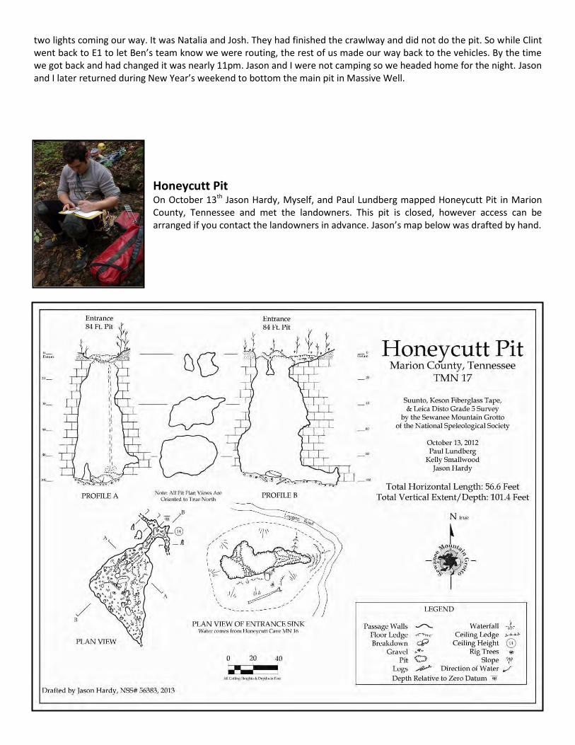
Honeycutt Pit On October 13th Jason Hardy, Myself, and Paul Lundberg mapped Honeycutt Pit in Marion County, Tennessee and met the landowners. This pit is closed, however access can be arranged if you contact the landowners in advance. Jason’s map below was drafted by hand.
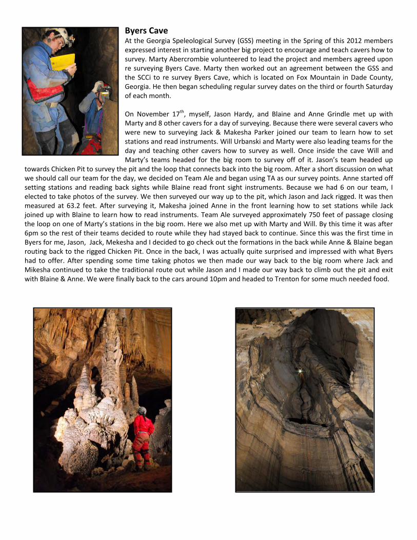
Byers Cave At the Georgia Speleological Survey (GSS) meeting in the Spring of this 2012 members expressed interest in starting another big project to encourage and teach cavers how to survey. Marty Abercrombie volunteered to lead the project and members agreed upon re surveying Byers Cave. Marty then worked out an agreement between the GSS and the SCCi to re survey Byers Cave, which is located on Fox Mountain in Dade County, Georgia. He then began scheduling regular survey dates on the third or fourth Saturday of each month. On November 17th, myself, Jason Hardy, and Blaine and Anne Grindle met up with Marty and 8 other cavers for a day of surveying. Because there were several cavers who were new to surveying Jack & Makesha Parker joined our team to learn how to set stations and read instruments. Will Urbanski and Marty were also leading teams for the day and teaching other cavers how to survey as well. Once inside the cave Will and Marty’s teams headed for the big room to survey off of it. Jason’s team headed up
towards Chicken Pit to survey the pit and the loop that connects back into the big room. After a short discussion on what we should call our team for the day, we decided on Team Ale and began using TA as our survey points. Anne started off setting stations and reading back sights while Blaine read front sight instruments. Because we had 6 on our team, I elected to take photos of the survey. We then surveyed our way up to the pit, which Jason and Jack rigged. It was then measured at 63.2 feet. After surveying it, Makesha joined Anne in the front learning how to set stations while Jack joined up with Blaine to learn how to read instruments. Team Ale surveyed approximately 750 feet of passage closing the loop on one of Marty’s stations in the big room. Here we also met up with Marty and Will. By this time it was after 6pm so the rest of their teams decided to route while they had stayed back to continue. Since this was the first time in Byers for me, Jason, Jack, Mekesha and I decided to go check out the formations in the back while Anne & Blaine began routing back to the rigged Chicken Pit. Once in the back, I was actually quite surprised and impressed with what Byers had to offer. After spending some time taking photos we then made our way back to the big room where Jack and Mikesha continued to take the traditional route out while Jason and I made our way back to climb out the pit and exit with Blaine & Anne. We were finally back to the cars around 10pm and headed to Trenton for some much needed food.
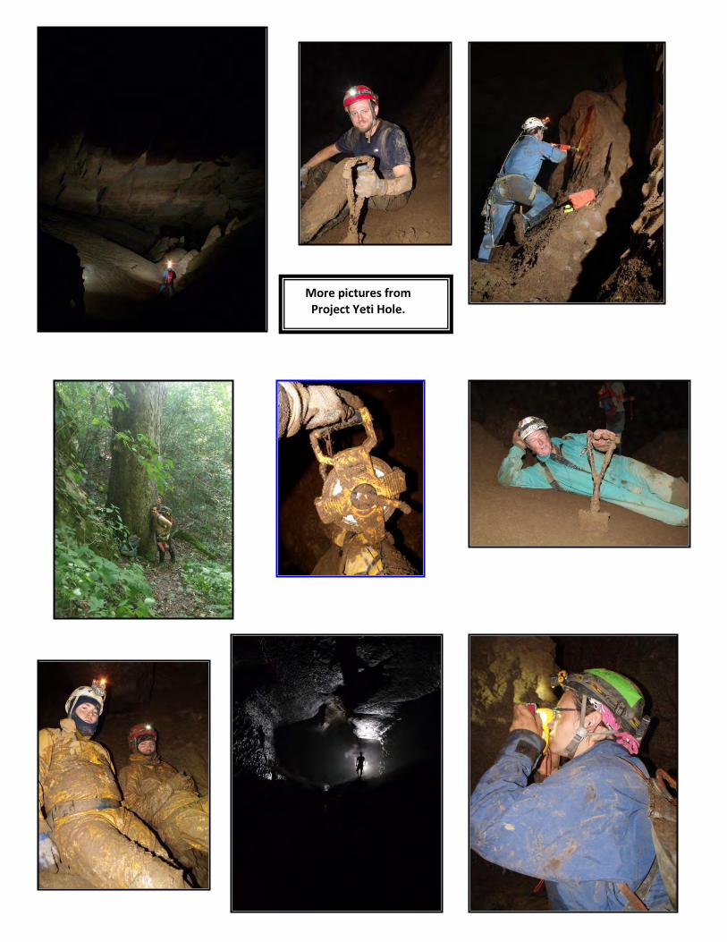
More pictures from Project Yeti Hole.
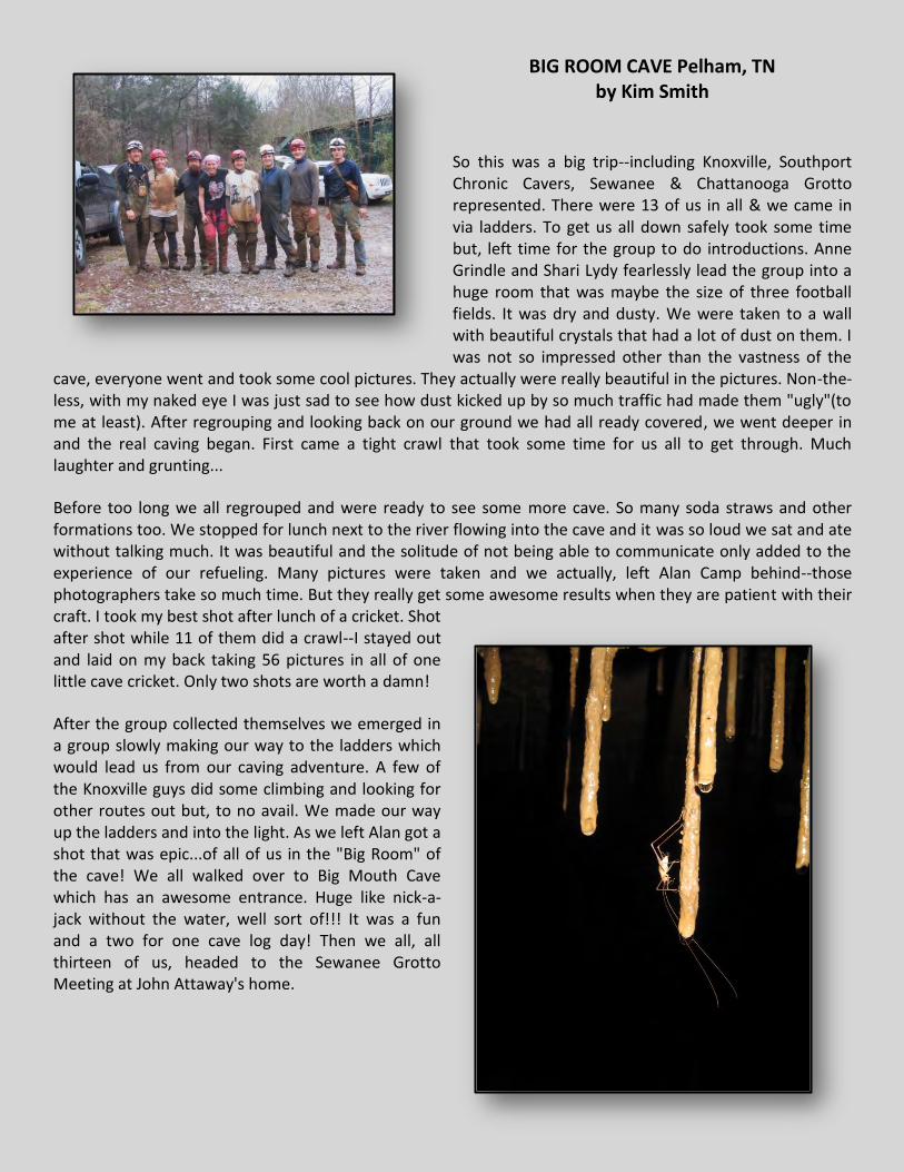
BIG ROOM CAVE Pelham, TN by Kim Smith
So this was a big trip--including Knoxville, Southport Chronic Cavers, Sewanee & Chattanooga Grotto represented. There were 13 of us in all & we came in via ladders. To get us all down safely took some time but, left time for the group to do introductions. Anne Grindle and Shari Lydy fearlessly lead the group into a huge room that was maybe the size of three football fields. It was dry and dusty. We were taken to a wall with beautiful crystals that had a lot of dust on them. I was not so impressed other than the vastness of the
cave, everyone went and took some cool pictures. They actually were really beautiful in the pictures. Non-the-less, with my naked eye I was just sad to see how dust kicked up by so much traffic had made them "ugly"(to me at least). After regrouping and looking back on our ground we had all ready covered, we went deeper in and the real caving began. First came a tight crawl that took some time for us all to get through. Much laughter and grunting...
Before too long we all regrouped and were ready to see some more cave. So many soda straws and other formations too. We stopped for lunch next to the river flowing into the cave and it was so loud we sat and ate without talking much. It was beautiful and the solitude of not being able to communicate only added to the experience of our refueling. Many pictures were taken and we actually, left Alan Camp behind--those photographers take so much time. But they really get some awesome results when they are patient with their craft. I took my best shot after lunch of a cricket. Shot after shot while 11 of them did a crawl--I stayed out and laid on my back taking 56 pictures in all of one little cave cricket. Only two shots are worth a damn!
After the group collected themselves we emerged in a group slowly making our way to the ladders which would lead us from our caving adventure. A few of the Knoxville guys did some climbing and looking for other routes out but, to no avail. We made our way up the ladders and into the light. As we left Alan got a shot that was epic...of all of us in the "Big Room" of the cave! We all walked over to Big Mouth Cave which has an awesome entrance. Huge like nick-a-jack without the water, well sort of!!! It was a fun and a two for one cave log day! Then we all, all thirteen of us, headed to the Sewanee Grotto Meeting at John Attaway's home.
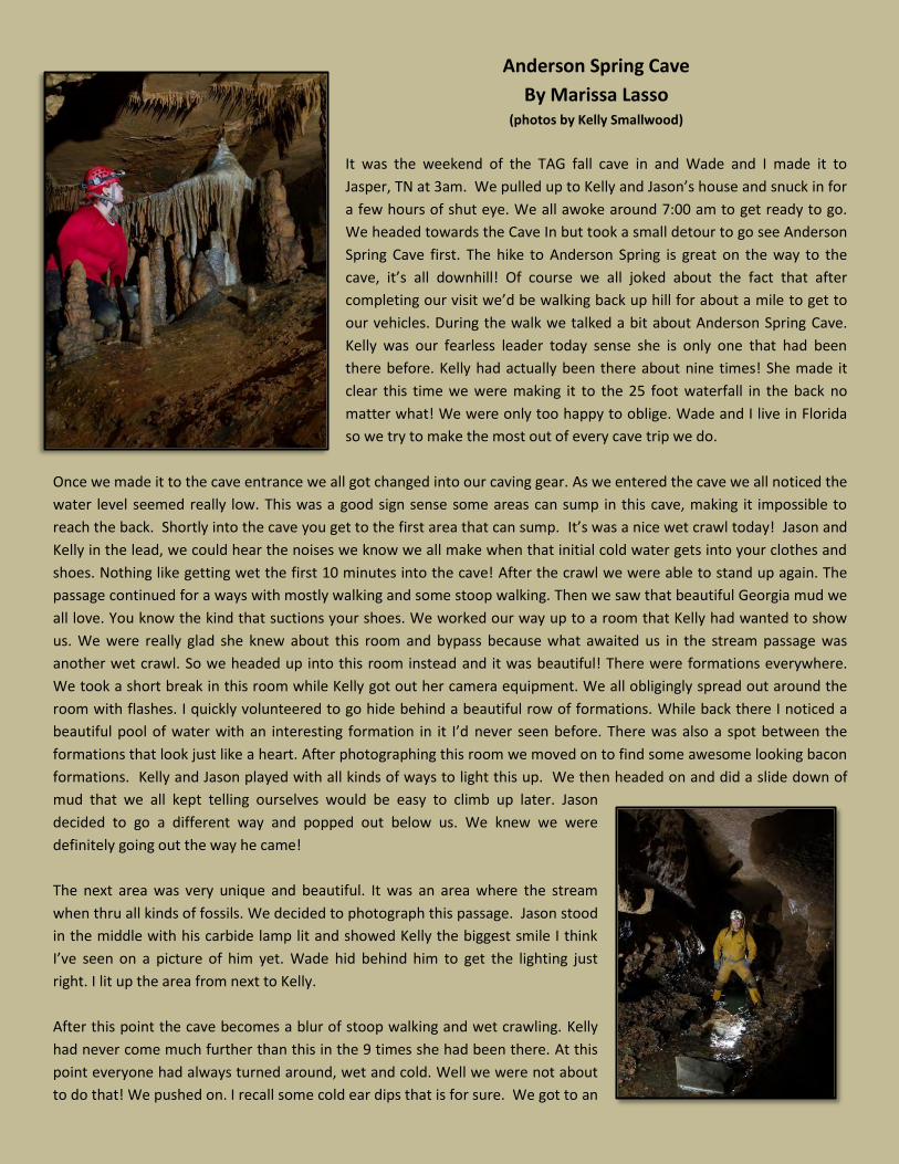
Anderson Spring Cave
By Marissa Lasso (photos by Kelly Smallwood)
It was the weekend of the TAG fall cave in and Wade and I made it to
Jasper, TN at 3am. We pulled up to Kelly and Jason’s house and snuck in for
a few hours of shut eye. We all awoke around 7:00 am to get ready to go.
We headed towards the Cave In but took a small detour to go see Anderson
Spring Cave first. The hike to Anderson Spring is great on the way to the
cave, it’s all downhill! Of course we all joked about the fact that after
completing our visit we’d be walking back up hill for about a mile to get to
our vehicles. During the walk we talked a bit about Anderson Spring Cave.
Kelly was our fearless leader today sense she is only one that had been
there before. Kelly had actually been there about nine times! She made it
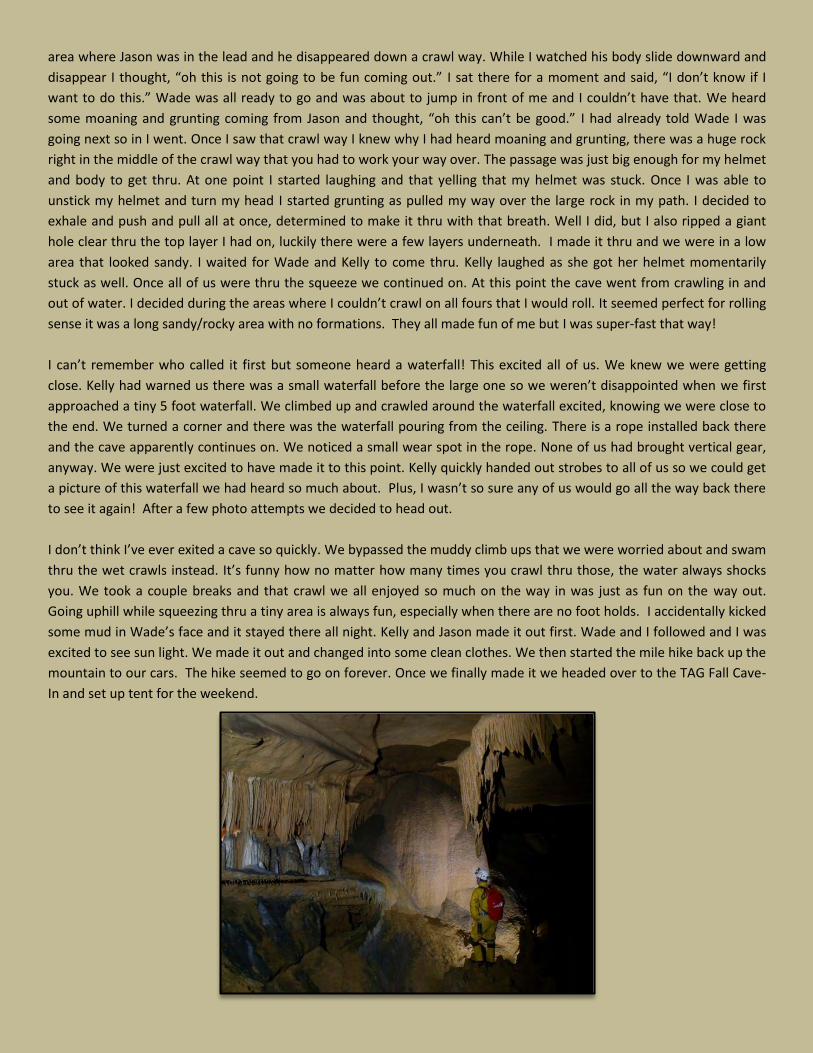
clear this time we were making it to the 25 foot waterfall in the back no
matter what! We were only too happy to oblige. Wade and I live in Florida
so we try to make the most out of every cave trip we do.
Once we made it to the cave entrance we all got changed into our caving gear. As we entered the cave we all noticed the
water level seemed really low. This was a good sign sense some areas can sump in this cave, making it impossible to
reach the back. Shortly into the cave you get to the first area that can sump. It’s was a nice wet crawl today! Jason and
Kelly in the lead, we could hear the noises we know we all make when that initial cold water gets into your clothes and
shoes. Nothing like getting wet the first 10 minutes into the cave! After the crawl we were able to stand up again. The
passage continued for a ways with mostly walking and some stoop walking. Then we saw that beautiful Georgia mud we
all love. You know the kind that suctions your shoes. We worked our way up to a room that Kelly had wanted to show
us. We were really glad she knew about this room and bypass because what awaited us in the stream passage was
another wet crawl. So we headed up into this room instead and it was beautiful! There were formations everywhere.
We took a short break in this room while Kelly got out her camera equipment. We all obligingly spread out around the
room with flashes. I quickly volunteered to go hide behind a beautiful row of formations. While back there I noticed a
beautiful pool of water with an interesting formation in it I’d never seen before. There was also a spot between the
formations that look just like a heart. After photographing this room we moved on to find some awesome looking bacon
formations. Kelly and Jason played with all kinds of ways to light this up. We then headed on and did a slide down of
mud that we all kept telling ourselves would be easy to climb up later. Jason
decided to go a different way and popped out below us. We knew we were
definitely going out the way he came!
The next area was very unique and beautiful. It was an area where the stream
when thru all kinds of fossils. We decided to photograph this passage. Jason stood
in the middle with his carbide lamp lit and showed Kelly the biggest smile I think
I’ve seen on a picture of him yet. Wade hid behind him to get the lighting just
right. I lit up the area from next to Kelly.
After this point the cave becomes a blur of stoop walking and wet crawling. Kelly
had never come much further than this in the 9 times she had been there. At this
point everyone had always turned around, wet and cold. Well we were not about
to do that! We pushed on. I recall some cold ear dips that is for sure. We got to an
area where Jason was in the lead and he disappeared down a crawl way. While I watched his body slide downward and
disappear I thought, “oh this is not going to be fun coming out.” I sat there for a moment and said, “I don’t know if I
want to do this.” Wade was all ready to go and was about to jump in front of me and I couldn’t have that. We heard
some moaning and grunting coming from Jason and thought, “oh this can’t be good.” I had already told Wade I was
going next so in I went. Once I saw that crawl way I knew why I had heard moaning and grunting, there was a huge rock
right in the middle of the crawl way that you had to work your way over. The passage was just big enough for my helmet
and body to get thru. At one point I started laughing and that yelling that my helmet was stuck. Once I was able to
unstick my helmet and turn my head I started grunting as pulled my way over the large rock in my path. I decided to
exhale and push and pull all at once, determined to make it thru with that breath. Well I did, but I also ripped a giant
hole clear thru the top layer I had on, luckily there were a few layers underneath. I made it thru and we were in a low
area that looked sandy. I waited for Wade and Kelly to come thru. Kelly laughed as she got her helmet momentarily
stuck as well. Once all of us were thru the squeeze we continued on. At this point the cave went from crawling in and
out of water. I decided during the areas where I couldn’t crawl on all fours that I would roll. It seemed perfect for rolling
sense it was a long sandy/rocky area with no formations. They all made fun of me but I was super-fast that way!
I can’t remember who called it first but someone heard a waterfall! This excited all of us. We knew we were getting
close. Kelly had warned us there was a small waterfall before the large one so we weren’t disappointed when we first
approached a tiny 5 foot waterfall. We climbed up and crawled around the waterfall excited, knowing we were close to
the end. We turned a corner and there was the waterfall pouring from the ceiling. There is a rope installed back there
and the cave apparently continues on. We noticed a small wear spot in the rope. None of us had brought vertical gear,
anyway. We were just excited to have made it to this point. Kelly quickly handed out strobes to all of us so we could get
a picture of this waterfall we had heard so much about. Plus, I wasn’t so sure any of us would go all the way back there
to see it again! After a few photo attempts we decided to head out.
I don’t think I’ve ever exited a cave so quickly. We bypassed the muddy climb ups that we were worried about and swam
thru the wet crawls instead. It’s funny how no matter how many times you crawl thru those, the water always shocks
you. We took a couple breaks and that crawl we all enjoyed so much on the way in was just as fun on the way out.
Going uphill while squeezing thru a tiny area is always fun, especially when there are no foot holds. I accidentally kicked
some mud in Wade’s face and it stayed there all night. Kelly and Jason made it out first. Wade and I followed and I was
excited to see sun light. We made it out and changed into some clean clothes. We then started the mile hike back up the
mountain to our cars. The hike seemed to go on forever. Once we finally made it we headed over to the TAG Fall Cave-
In and set up tent for the weekend.
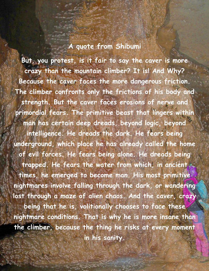
A quote from Shibumi
But, you protest, is it fair to say the caver is more
crazy than the mountain climber? It is! And Why?
Because the caver faces the more dangerous friction.
The climber confronts only the frictions of his body and
strength. But the caver faces erosions of nerve and
primordial fears. The primitive beast that lingers within
man has certain deep dreads, beyond logic, beyond
intelligence. He dreads the dark. He fears being
underground, which place he has already called the home
of evil forces. He fears being alone. He dreads being
trapped. He fears the water from which, in ancient
times, he emerged to become man. His most primitive
nightmares involve falling through the dark, or wandering
lost through a maze of alien chaos. And the caver, crazy
being that he is, volitionally chooses to face these
nightmare conditions. That is why he is more insane than
the climber, because the thing he risks at every moment
in his sanity.
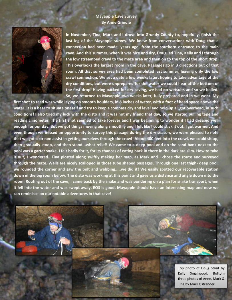
Mayapple Cave Survey
By Anne Grindle
In November, Tina, Mark and I drove into Grundy County to, hopefully, finish the
last leg of the Mayapple survey. We knew from conversations with Doug that a
connection had been made, years ago, from the southern entrance to the main
cave. And this summer, when it was nice and dry, Doug led Tina, Kelly and I through
the low streambed crawl to the maze area and then on to the top of the short drop.
This overlooks the largest room in the cave. Passages go in 3 directions out of that
room. All that survey area had been completed last summer, leaving only the low
crawl connection. We set a date a few weeks later, hoping to take advantage of the
dry conditions, but were unprepared for the water we could hear at the bottom of
the first drop. Having packed for dry caving, we had no wetsuits and so we bailed.
So, we returned to Mayapple two weeks later, fully prepared and in we went. My
first shot to read was while laying on smooth boulders, in 8 inches of water, with a foot of head space above the
water. It is a bear to situate oneself and try to keep a compass dry and level and hold up a light overhead, in such
conditions! I also tried my luck with the disto and it was not my friend that day, so we started pulling tape and
reading clinometer. The first shot seemed to take forever and I was beginning to wonder if I had dressed well
enough for our day. But we got things moving along smoothly and I felt like I could stick it out. I got warmer. And
even though we missed an opportunity to survey this passage during the dry season, we were pleased to note
that we got a stream assist in getting ourselves through the crawl! About 400 feet into the crawl, we could sit up,
then gradually stoop, and then stand...what relief! We came to a deep pool and on the sand bank next to the
pool was a garter snake. I felt badly for it, for its chances of eating back in there in the dark are slim. How to take
it out, I wondered...Tina plotted along swiftly making her map, as Mark and I chose the route and surveyed
through the maze. Walls are nicely scalloped in those tube shaped passages. Through one last thigh- deep pool,
we rounded the corner and saw the bolt and webbing.....we did it! We easily spotted our recoverable station
down in the big room below. The disto was working at this point and gave us a distance and angle down into the
room. Routing out of the cave, I came back by the snake and was pondering on a plan for snake transport, when
it fell into the water and was swept away. EOS is good. Mayapple should have an interesting map and now we
can reminisce on our notable adventures in that cave!
Top photo of Doug Strait by
Kelly Smallwood. Bottom
three photos of Anne, Mark &
Tina by Mark Ostrander.
Danja Mewes, NSS #63434
In the Fall of 2012, I had the opportunity as an undergraduate Earth and Atmospheric Science student to accompany a Georgia Tech
expedition to Borneo. The graduate students, Stacy Carolin and Jessica Moerman were conducting paleoclimate research in caves in
Mulu National Park. Their advisor, Professor Kim Cobb, Ph.D, has been researching there for nearly a decade. I also had my own
small project on the microclimate of a cave, Lang’s Cave, located adjacent to the well-known Deer Cave, using sensors to record
temperature, humidity, pressure and air velocity over the period of a month. The following are excerpts from my journal during my
stay in Borneo:
As we landed at the Mulu airport, which is the smallest actual airport I have flown into, a flock of white birds took off from a tree
next to the runway, taking note of our arrival.
The small airport was indicated by a “Welcome to Mulu” sign.
I never had asked what Brian looked like; only heard of his character – so I was expecting a Malaysian - but this park manager was
definitely not Malaysian. From his khaki outfit and his greying hair and moustache to his Australian accent, he could easily have
passed for a wilderness guide for an adventure in the Outback.
We loaded our boxes and bags into the back of Brian’s truck using all woman- power. all woman-power. Behind the airport were
more shacks where people lived and a gravel road running between them. We pulled off onto the gravel road and the pickup
bounced along, sending clouds of dust up behind us; short-lived as a small rainstorm had just arrived.
We pulled up to a rope bridge with a wooden floor, the entrance to the park, and two men from the park unloaded our heavy bags
and boxes and loaded them over into a wheeled cart.
“Tera makisey!” Stacy said (thank you in Malay) as we headed across the swinging footbridge in the drizzly rain.
In his office, Brian showed us some pictures of interesting semicircular features in a cave. I guessed they were eroded flowstone,
but apparently they were from birds (swallows) which people now go into caves to retrieve illegally as they can fetch 2000 MYR
(~$650) per kg. They are a local delicacy and poaching of the swallows’ eggs is a persistent problem in Borneo.
In the main Mulu office an athletic Malaysian came bounding out from behind the counter. She recognized Stacy and Jessica and
embraced them. “SYRIA!” they exclaimed. I smiled and shook her hand. This was Syria, the The woman I had heard so much about.
“5:30 we meet for dinner?”
We all said yes.
Syria joined us for dinner and caught up with the latest news from Jessica and Stacy. We spoke with her for just shy of 4 hours,
during which I came to know more about this woman of the jungle.
Syria is a female Bornean Chuck Norris. She knows 20 languages, sleeps very little has saved a drowning man and probably many
more lives. She is considered one of the best guides and has a philosophy that knowledge is the pinnacle of life. This 5 foot tall
woman will never be seen wearing a dress but she will always be seen with a smile, talkative and full of energy.
Halfway through our conversation, a British expedition team joined us. “Ah, you have a Mulu virgin,” said Andy Eavis, Britsh caving
legend. I hoped that I could redeem myself as more than just a “Mulu virgin”. Andy spoke of caving with the caving gods. I tried to
bring the conversation closer to home and finally stuck common ground when I asked if he knew of our TAG caving hero, Marion
Smith. And indeed, Andy had caved with Marion when he was 26 years old on an expedition in Mexico. That’s when I realized Andy
Eavis must be a caving god, too. I wasn’t sure whether to bow or smile whenever we crossed paths, but he and his team greeted us
like acquaintances each time we saw them in passing – so I chose the latter.
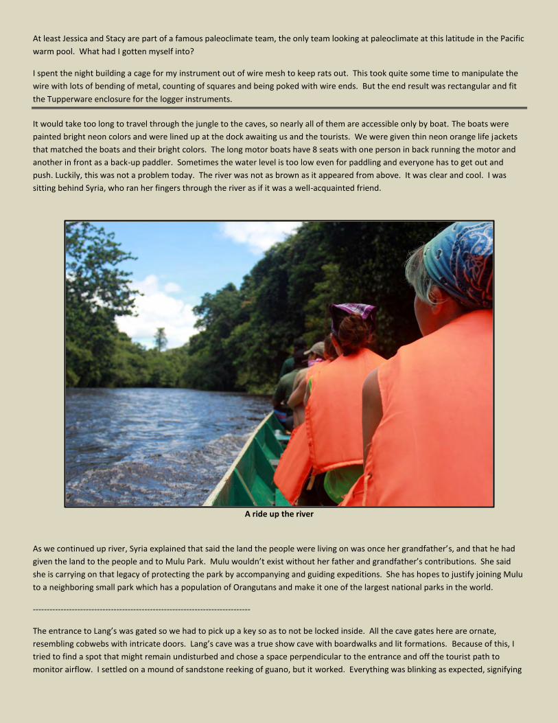
At least Jessica and Stacy are part of a famous paleoclimate team, the only team looking at paleoclimate at this latitude in the Pacific
warm pool. What had I gotten myself into?
I spent the night building a cage for my instrument out of wire mesh to keep rats out. This took quite some time to manipulate the
wire with lots of bending of metal, counting of squares and being poked with wire ends. But the end result was rectangular and fit
the Tupperware enclosure for the logger instruments.
It would take too long to travel through the jungle to the caves, so nearly all of them are accessible only by boat. The boats were
painted bright neon colors and were lined up at the dock awaiting us and the tourists. We were given thin neon orange life jackets
that matched the boats and their bright colors. The long motor boats have 8 seats with one person in back running the motor and
another in front as a back-up paddler. Sometimes the water level is too low even for paddling and everyone has to get out and
push. Luckily, this was not a problem today. The river was not as brown as it appeared from above. It was clear and cool. I was
sitting behind Syria, who ran her fingers through the river as if it was a well-acquainted friend.
A ride up the river
As we continued up river, Syria explained that said the land the people were living on was once her grandfather’s, and that he had
given the land to the people and to Mulu Park. Mulu wouldn’t exist without her father and grandfather’s contributions. She said
she is carrying on that legacy of protecting the park by accompanying and guiding expeditions. She has hopes to justify joining Mulu
to a neighboring small park which has a population of Orangutans and make it one of the largest national parks in the world.
------------------------------------------------------------------------------
The entrance to Lang’s was gated so we had to pick up a key so as to not be locked inside. All the cave gates here are ornate,
resembling cobwebs with intricate doors. Lang’s cave was a true show cave with boardwalks and lit formations. Because of this, I
tried to find a spot that might remain undisturbed and chose a space perpendicular to the entrance and off the tourist path to
monitor airflow. I settled on a mound of sandstone reeking of guano, but it worked. Everything was blinking as expected, signifying
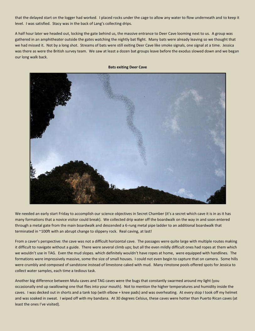
that the delayed start on the logger had worked. I placed rocks under the cage to allow any water to flow underneath and to keep it
level. I was satisfied. Stacy was in the back of Lang’s collecting drips.
A half hour later we headed out, locking the gate behind us, the massive entrance to Deer Cave looming next to us. A group was
gathered in an amphitheater outside the gates watching the nightly bat flight. Many bats were already leaving so we thought that
we had missed it. Not by a long shot. Streams of bats were still exiting Deer Cave like smoke signals, one signal at a time. Jessica
was there as were the British survey team. We saw at least a dozen bat groups leave before the exodus slowed down and we began
our long walk back.
Bats exiting Deer Cave
We needed an early start Friday to accomplish our science objectives in Secret Chamber (it’s a secret which cave it is in as it has
many formations that a novice visitor could break). We collected drip water off the boardwalk on the way in and soon entered
through a metal gate from the main boardwalk and descended a 6-rung metal pipe ladder to an additional boardwalk that
terminated in ~100ft with an abrupt change to slippery rock. Real caving, at last!
From a caver’s perspective: the cave was not a difficult horizontal cave. The passages were quite large with multiple routes making
it difficult to navigate without a guide. There were several climb ups; but all the even mildly difficult ones had ropes at them which
we wouldn’t use in TAG. Even the mud slopes. which definitely wouldn’t have ropes at home, were equipped with handlines. The
formations were impressively massive, some the size of small houses. I could not even begin to capture that on camera. Some hills
were crumbly and composed of sandstone instead of limestone caked with mud. Many rimstone pools offered spots for Jessica to
collect water samples, each time a tedious task.
Another big difference between Mulu caves and TAG caves were the bugs that constantly swarmed around my light (you
occasionally end up swallowing one that flies into your mouth). Not to mention the higher temperatures and humidity inside the
caves. I was decked out in shorts and a tank top (with elbow + knee pads) and was overheating. At every stop I took off my helmet
and was soaked in sweat. I wiped off with my bandana. At 30 degrees Celsius, these caves were hotter than Puerto Rican caves (at
least the ones I’ve visited).
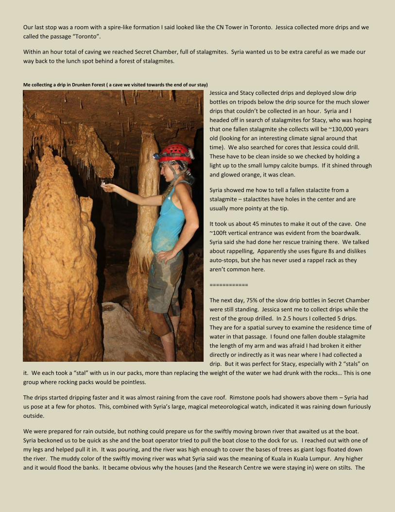
Our last stop was a room with a spire-like formation I said looked like the CN Tower in Toronto. Jessica collected more drips and we
called the passage “Toronto”.
Within an hour total of caving we reached Secret Chamber, full of stalagmites. Syria wanted us to be extra careful as we made our
way back to the lunch spot behind a forest of stalagmites.
Me collecting a drip in Drunken Forest ( a cave we visited towards the end of our stay)
Jessica and Stacy collected drips and deployed slow drip
bottles on tripods below the drip source for the much slower
drips that couldn’t be collected in an hour. Syria and I
headed off in search of stalagmites for Stacy, who was hoping
that one fallen stalagmite she collects will be ~130,000 years
old (looking for an interesting climate signal around that
time). We also searched for cores that Jessica could drill.
These have to be clean inside so we checked by holding a
light up to the small lumpy calcite bumps. If it shined through
and glowed orange, it was clean.
Syria showed me how to tell a fallen stalactite from a
stalagmite – stalactites have holes in the center and are
usually more pointy at the tip.
It took us about 45 minutes to make it out of the cave. One
~100ft vertical entrance was evident from the boardwalk.
Syria said she had done her rescue training there. We talked
about rappelling, Apparently she uses figure 8s and dislikes
auto-stops, but she has never used a rappel rack as they
aren’t common here.
============
The next day, 75% of the slow drip bottles in Secret Chamber
were still standing. Jessica sent me to collect drips while the
rest of the group drilled. In 2.5 hours I collected 5 drips.
They are for a spatial survey to examine the residence time of
water in that passage. I found one fallen double stalagmite
the length of my arm and was afraid I had broken it either
directly or indirectly as it was near where I had collected a
drip. But it was perfect for Stacy, especially with 2 “stals” on
it. We each took a “stal” with us in our packs, more than replacing the weight of the water we had drunk with the rocks… This is one
group where rocking packs would be pointless.
The drips started dripping faster and it was almost raining from the cave roof. Rimstone pools had showers above them – Syria had
us pose at a few for photos. This, combined with Syria’s large, magical meteorological watch, indicated it was raining down furiously
outside.
We were prepared for rain outside, but nothing could prepare us for the swiftly moving brown river that awaited us at the boat.
Syria beckoned us to be quick as she and the boat operator tried to pull the boat close to the dock for us. I reached out with one of
my legs and helped pull it in. It was pouring, and the river was high enough to cover the bases of trees as giant logs floated down
the river. The muddy color of the swiftly moving river was what Syria said was the meaning of Kuala in Kuala Lumpur. Any higher
and it would flood the banks. It became obvious why the houses (and the Research Centre we were staying in) were on stilts. The
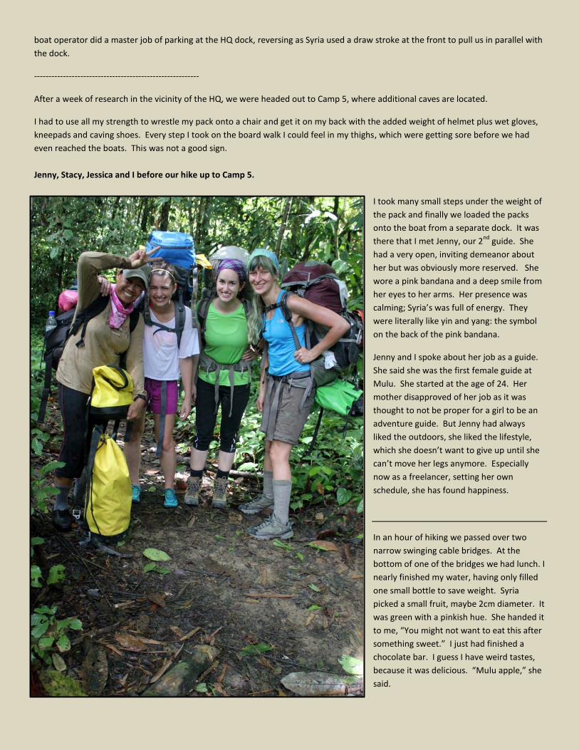
boat operator did a master job of parking at the HQ dock, reversing as Syria used a draw stroke at the front to pull us in parallel with
the dock.
---------------------------------------------------------
After a week of research in the vicinity of the HQ, we were headed out to Camp 5, where additional caves are located.
I had to use all my strength to wrestle my pack onto a chair and get it on my back with the added weight of helmet plus wet gloves,
kneepads and caving shoes. Every step I took on the board walk I could feel in my thighs, which were getting sore before we had
even reached the boats. This was not a good sign.
Jenny, Stacy, Jessica and I before our hike up to Camp 5.
I took many small steps under the weight of
the pack and finally we loaded the packs
onto the boat from a separate dock. It was
there that I met Jenny, our 2nd
guide. She
had a very open, inviting demeanor about
her but was obviously more reserved. She
wore a pink bandana and a deep smile from
her eyes to her arms. Her presence was
calming; Syria’s was full of energy. They
were literally like yin and yang: the symbol
on the back of the pink bandana.
Jenny and I spoke about her job as a guide.
She said she was the first female guide at
Mulu. She started at the age of 24. Her
mother disapproved of her job as it was
thought to not be proper for a girl to be an
adventure guide. But Jenny had always
liked the outdoors, she liked the lifestyle,
which she doesn’t want to give up until she
can’t move her legs anymore. Especially
now as a freelancer, setting her own
schedule, she has found happiness.
In an hour of hiking we passed over two
narrow swinging cable bridges. At the
bottom of one of the bridges we had lunch. I
nearly finished my water, having only filled
one small bottle to save weight. Syria
picked a small fruit, maybe 2cm diameter. It
was green with a pinkish hue. She handed it
to me, “You might not want to eat this after
something sweet.” I just had finished a
chocolate bar. I guess I have weird tastes,
because it was delicious. “Mulu apple,” she
said.
Camp 5 – Gunung Benarat
We passed limestone outcrops and trees with large roots on the way to Camp 5. It was beginning to rain lightly so I did not take my
camera out. After 4 more km through the woods, back and shoulders aching, there was a light glowing through the trees. We had
reached Camp 5. I don’t know what I was expecting, but it was not picnic shelters and a metal roof over my head. Camp 5 was
equipped with a kitchen, bathrooms and covered walkways. Sweat bees swarmed around us, our shoes, our packs. Everything was
covered with sweat. A sign also declared their presence, telling new arrivals to remove sweaty gear and shower. A green sign on
the building read, “Selamat datang ke Camp 5” (Welcome to Camp 5). Everyone had gotten leeches but me, the one wearing shorts
instead of pants. I had sprayed my thick wool socks with DEET, a trick I had read about online, which seemed to be working.
I was excited for the Pinnacles the next day. They are towers of limestone rising out of the jungle, one of what Syria calls the “true
wonders of the world”. We watched the river behind us and Gunung Benarat’s peak rising above us, shrouded in mist.
The Pinnacles
It rained too hard early in the morning for our planned outing to
see the Pinnacles. As I learned a few weeks later, the path up to
the Pinnacles is comprised mostly of roots and then ropes and
ladders. The trail is slippery and steep, a long arduous hike even
without rain. So we set off to obtain samples from White Rock, a
cave inaccessible to tourists. We turned just over halfway back
down to the river we had come from the first day and began
traipsing through the jungle on what by caving standards was a
bonafied path. The jungle leaves almost looked like a post-Fall tapestry on the ground: yellow, orange-brown and green. Vines and
roots tripped us; the jungle wanting to keep its visitors and bring us closer to its heart.
I followed Jenny, through 5 stream crossings and twists and turns. Our feet were wet and soggy. To me it was no more difficult than
your average hike in the forest. Sometimes muddy, but the thick Rotan thorns (as thick as a finger!) had been cleared well away
from the trail yesterday by our guides. They had also scraped bark off trees at regular intervals to mark the way into the heart of the
jungle.
We crossed over the streams, past giant trees, back to the spot where the trail turned uphill – and finally began the long scramble to
the cave – over roots, holding onto sharp rocks, soft spongy soil below us. My foot fell through one of these spongy spots and my
heart nearly skipped a beat. But I was fine and we pressed on. The afternoon sun was shining down on us and we were drenched
with sweat, stopping to take a breath every few minutes. Jenny apologized for “breathing like a rhinoceros,” but if she was I could
hardly hear it over my own labored breathing.
Half an hour later we neared the entrance of White Rock, cool air blowing towards us. We crossed the last corner, an exposed spot
with sharp limestone handholds and quite a
tumble below. I hung on with one hand and
swung around the corner, feet touching solid
ground. The mouth of the cave awaited me,
ready to swallow me whole.
The whole crew at the entrance to White
Rock Cave (photo by Syria).
White Rock’s passage consists of a lot of
breakdown. Crumbly, brittle breakdown that
falls apart if you step on the wrong section of
it (it reminded me a little of portions of a safer
version of one of Kelly Smallwood and Jason
Hardy’s Fall 2012 survey projects in TAG).
Nesters have found and pillaged the cave, as
evidenced by spray painted arrows. It was not
as hot as the other caves we have visited and
most of the caving consisted of walking over
breakdown and was simply a balancing act.
We were looking for drips for the two
scientists. At one junction Syria and I explored
further and found a sea of “coral” (what they
call popcorn) – it was stunning. Untouched,
beautiful, nothing like popcorn I had ever seen
and exactly reminiscent of a bed of coral. I
was very careful not to step on it.
Neat formations in White Rock Cave
As we ate lunch, Jenny told Syria that she thought I should be called Bunga. Everyone who stays here long enough receives a local
name. Stacy is Mujan, after Jenny’s mother. Jessica is Diyan, which means royalty. Bunga is flower. I don’t think I am dainty like a
flower, but maybe Jenny sees something good in my soul (actually, apparently it refers to my colorful hair).
We reached a junction Jessica thought was near the end of the section they had been in on the previous expedition. Stacy and I
collected drips while the others pressed on. We both finished our scientific tasks relatively soon and were sitting for a while,
waiting. It was chilly enough in this cave that I ended up needing to put on my long sleeve shirt when I was sitting still. I ducked into
a small tunnel under a large pile of stable breakdown, but it was just a dead end.
Then we heard their voices and saw their lights emerging from around a bend in the distance. We turned back as a group and
headed to the entrance of White Rock. It was raining and vines caught us. The darkness was beginning to encroach on the light as
we reached the main trail to Camp 5.
It was dusk when we arrived in Camp 5. Our professor Kim and students Eleanor and Sang had arrived.
Once everyone was asleep, Syria and I spoke about the difference between scientists and cavers, the difference in mindset and
where the overlap is in exploration, conservation, observation and data acquisition. I talked to Kim about it a few days later and find
out that scientists, much to my chagrin, are perhaps even more conservation-minded then cavers, often seeing the exploration as
potentially damaging to the caves they are researching.
Rest was not exactly in order the next day, although we did not make the return trip to White Rock. Instead, we were headed to
Cobweb Cave. Everyone seemed mildly scared of the cave. I was hoping this would mean I would like it. The entrance was truly a
mouth with weathered stalactite teeth hanging down over a dirt slope into the cave. From experience it really was not dangerous,
but Syria had us all get on our butts and go around the outside edge along the wall.
The main passage was a lot more like TAG caving, huge breakdown to climb over and between. It took a little while to find the
passage we were looking for. Syria said people have been seriously lost in the cave before.
On top of breakdown in Cobweb cave
I was really happy when we reached an area with
one 50ft crawl. I was smiling bigger by then, as I
felt much more at home. We ended up in a drippy
passage where we collected, of course, drip
waters. Standing around for that long, the room
felt chilly enough to warrant putting my long
sleeve shirt on. Syria climbed up to a drip above
us and I scrambled up to shuttle her vials. I wish I
could have done more of that on this trip.
After a lunch break, we still needed to get to the
“Big Stal room”. Syria, Stacy, Jessica, Eleanor and I
set off to find this room, climbing over breakdown.
But no such luck. Syria had us turn around. We
really needed the drips though, and Syria was
pretty sure she knew where they were. So she had Jessica and I follow her back, feeling more comfortable with a smaller group.
Now it felt like we were caving, larger drops around us, walking on large slabs of breakdown with more gaps to stretch legs out to.
Finally, a caver’s cave.
We heard water and saw more black rocks. Syria and Jessica remembered a showerhead and a black rock near the room, so we
followed the sounds to the “Big Stal”, a 6ft tall stalagmite in the center of a drippy chamber. We each collected a few vials, and I
was the “lab camera”, taking the scientific shots Jessica needed as we were having technical difficulties with the actual lab camera.
Jessica collecting a drip at the entrance to Cobweb Cave
I got to see the mini-core filling process in detail and document it. Following the
drilling of a mini-core sample, a piece of foam is cut out to fit the top of the stal.
Then clay-like epoxy is placed over this and the top of the stal is sealed from
corrosion. The stal is rinsed using a plastic bottle of pool water from the cave, in
case any dirt or shavings got on it in the coring process. It usually looks cleaner
than it did to begin with, but the white cap indicates that something has been
done to the stal, if you can see them. Usually only very small, several cm wide
cores are drilled, which are carefully transported back in a padded Tupperware
container.
We had a huge “family dinner” on Stacy’s birthday, consisting of a potluck of
deliciously flavored jungle greens, fish, tofu and chili Mathilda and I had made
(but mostly Mathilda). After this we passed around a bottle of Gold Bond,
powdering our feet to keep the relentless “Mulu foot” (a fungal condition that
seems to effect both feet and camera lenses) at bay. It stung. The others told
me that is how I would know it was working.
I collected my first leech the next day and removed it with Jenny’s assistance. It
must have been the Gold Bond on my feet. Either that or I was running out of
DEET. At least I had finally proven that my blood was not sour. The jungle had
accepted me into its midst.
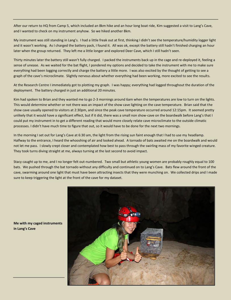
After our return to HQ from Camp 5, which included an 8km hike and an hour long boat ride, Kim suggested a visit to Lang’s Cave,
and I wanted to check on my instrument anyhow. So we hiked another 8km.
My instrument was still standing in Lang’s. I had a little freak out at first, thinking I didn’t see the temperature/humidity logger light
and it wasn’t working. As I charged the battery pack, I found it. All was ok, except the battery still hadn’t finished charging an hour
later when the group returned. They left me a little longer and explored Deer Cave, which I still hadn’t seen.
Thirty minutes later the battery still wasn’t fully charged. I packed the instruments back up in the cage and re-deployed it, feeling a
sense of unease. As we waited for the bat flight, I pondered my options and decided to take the instrument with me to make sure
everything had been logging correctly and charge the battery a little more. I was also excited by the thought of getting to see a
graph of the cave’s microclimate. Slightly nervous about whether everything had been working, more excited to see the results.
At the Research Centre I immediately got to plotting my graph. I was happy; everything had logged throughout the duration of the
deployment. The battery charged in just an additional 20 minutes.
Kim had spoken to Brian and they wanted me to go 2-3 mornings around 6am when the temperatures are low to turn on the lights.
This would determine whether or not there was an impact of the show cave lighting on the cave temperature. Brian said that the
show cave usually opened to visitors at 2:30pm, and since the peak cave temperature occurred around 12:15pm. It seemed pretty
unlikely that it would have a significant effect, but if it did, there was a small non show-cave on the boardwalk before Lang’s that I
could put my instrument in to get a different reading that would more closely relate cave microclimate to the outside climatic
processes. I didn’t have much time to figure that out, so it would have to be done for the next two mornings.
In the morning I set out for Lang’s Cave at 6:30 am, the light from the rising sun faint enough that I had to use my headlamp.
Halfway to the entrance, I heard the whooshing of air and looked ahead. A tornado of bats awaited me on the boardwalk and would
not let me pass. I slowly crept closer and contemplated how best to pass through the swirling mass of my favorite winged creature.
They took turns diving straight at me, always turning at the last second to avoid impact.
Stacy caught up to me, and I no longer felt out-numbered. Two small but athletic young women are probably roughly equal to 100
bats. We pushed through the bat tornado without any difficulty and continued on to Lang’s Cave. Bats flew around the front of the
cave, swarming around one light that must have been attracting insects that they were munching on. We collected drips and I made
sure to keep triggering the light at the front of the cave for my dataset.
Me with my caged instruments
in Lang’s Cave
Of all of my nights at Mulu, one night stands out in particular, more than the “family meals” and shared laughter:
Syria had returned from finding the trail to White Rock and was sipping tea with Jessica and Stacy who had filled about 30 vials with
rain samples throughout the storm. We received news via the radio that Kim didn’t make it on the flight to Mulu. It had been
canceled but she could still get to Camp 5 tomorrow if she made the morning flight. Her heart was already here, and we knew that.
Conversation quickly turned to Socratic discourse as we sipped hot, sugary tea.
“Who make you alive?,” asked Syria. I thought she was asking what makes me feel alive.
I said running through the woods with rocks and roots and all sorts of natural obstacles makes me feel alive and puts me in touch
with nature, what I had done that day along the Melinau Gorge.
Syria said, “No, not what. WHO….”
“What makes you think?” clarified Syria after a few moments of silence.
“My brain…”
“No”
“Me?...”
Syria shook her head. “In here,” she said, pointing at her heart. “That make you alive.”
“Nature,” Syria said. “Without trees, you cannot breathe. We need nature to be alive.” She paused. “And this,” clasping her heart
again.
For dinner we had rice with extremely salty fermented fish. It is a local delicacy, straight from the river 50ft away, but nearly putrid.
No one finished theirs’ except Jenny. Stacy and I offered to clean dishes and I scraped the remaining fish into the compost bin
where you could see the heads of the fish still lying, their eyes staring at the ceiling.
Syria and I talked about ropes and knots. She taught me some tricks with pull-downs and other ways to tie webbing, I showed her a
funny way of tying the butterfly knot; 3 twists: head, body, butt. Put the head between the legs and up the butt. She found that
amusing.
Over the last cup of tea for the night, Syria told us she is always helping change people’s hearts. She told a story about how she
went shopping once at the supermarket and asked her group where everything had come from.
“Factory,” they said.
“No,” said Syria, “all from nature.”
As they tried to find something not from nature she kept explaining how it was.
“Milk!” one had said.
“From cow. Cows eat grass,” she had countered. “When nature all gone, we have nothing, no matter how rich we are.”
And in that single moment I understood the magic of Mulu.
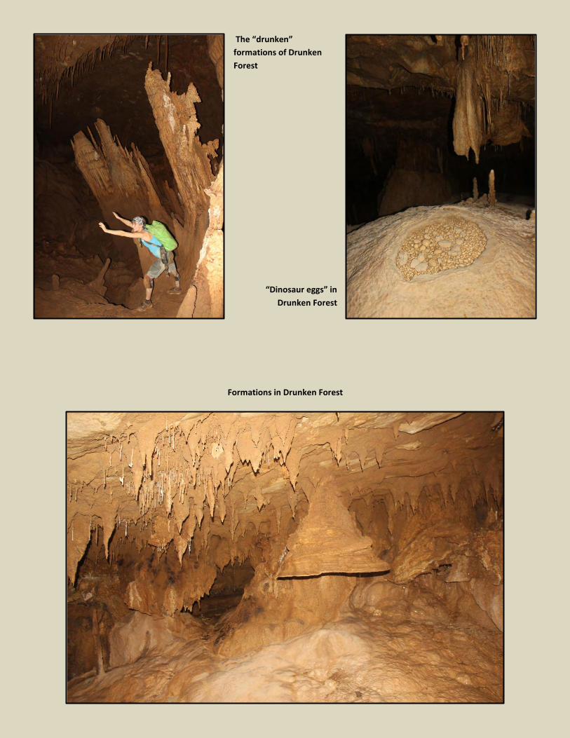
The “drunken”
formations of Drunken
Forest
“Dinosaur eggs” in
Drunken Forest
Formations in Drunken Forest