Embed Size (px)
Citation preview
TENNESSEE ENVIROTHON AQUATICS STUDY GUIDE
George F. Smith University of Tennessee Extension
This study guide is divided into the 12 aquatic ecology learning objectives for the Canon Envirothon (http://www.envirothon.org/education/aquaticskeypoints.pdf). The guide outlines key concepts. Detailed information is not included to keep it to a reasonable length. Some website links are included. The Canon Envirothon website (http://www.envirothon.org/education/resources_us.php) lists more links to resources. Other sources for explanations and more detail are your biology, chemistry and environmental science text books and references in your school and public libraries.
LEARNING OBJECTIVES
The aquatic ecology learning objectives for the Canon Envirothon are:
1. Identify the processes and phases for each part of the water cycle. 2. Describe the chemical and physical properties of water and explain their implications for freshwater and saltwater ecosystems. 3. Analyze the interaction of competing uses of water for water supply, hydropower, navigation, wildlife, recreation, waste assimilation, irrigation, industry, and others. 4. Discuss methods of conserving water and reducing point and non-point source pollution. 5. Identify common aquatic organisms through the use of a key. 6. Delineate the watershed boundary for a small water body. 7. Explain the different types of aquifers and how each type relates to water quantity and quality. 8. Briefly describe the benefits of wetlands, including both function and value. 9. Describe the benefits of riparian areas, including both function and value. 10. Describe the changes to the aquatic ecosystem based on alteration to the aquatic habitat. 11. Know methods used to assess and manage aquatic environments and be able to utilize water quality information to assess the general water quality of a specific body of water. This includes sampling, technique, and water quality parameters used to monitor point and non-point source pollution. 12. Be familiar with major methods and laws used to protect water quality (i.e., both surface and ground water) and utilize this information to make management decisions to improve the quality of water in a given situation. 1. The Water Cycle. The earth is a closed system. The total amount of water on earth is constant. The water that exists now has always existed. The water in your next shower may have been drunk by a dinosaur or floated Cleopatra’s barge on the Nile River!
Water moves in a never ending natural cycle known as the water cycle or the hydrologic cycle. Since it is continuous, the water cycle really doesn’t have a beginning, but a convenient place to start is with precipitation (rain, snow, sleet or hail). Some of the precipitation soaks into the soil and is stored as groundwater. Some of it flows into streams, lakes, wetlands and oceans as surface runoff. Water can be returned to the atmosphere by evaporation or by transpiration through plants. Groundwater moves back to the surface through springs, underground flows into surface water bodies, or through wells we drill. Some water stored in ice and snow also changes directly into gas in a process called
sublimation. Water vapor rises into the sky and forms clouds. When the vapor in the clouds condenses, it falls back to earth as precipitation. The water cycle has then come full circle and begins again.
As water changes into a gas, it leaves behind contaminants it may have picked up in its liquid or solid form. This natural purification and renewal is critical in maintaining its quality and sustaining life. We copy this natural process in distillation and use it to purify water and other liquids. NASA has a great website on the water cycle with animated diagrams at: http://observe.arc.nasa.gov/nasa/earth/hydrocycle/hydro2.html 2. The Chemical and Physical Properties of Water. Each water molecule consists of one oxygen and two hydrogen atoms. In shape, a water molecule resembles a “Mickey Mouse” head; the “face” is the oxygen atom and the “ears” are the hydrogen atoms. In its pure state, water is colorless, odorless and tasteless.
Water molecules are polar (acting just like a magnet); the hydrogen end has a positive charge, the oxygen end has a negative charge. Since opposite electrical charges attract, water molecules tend to attract each other, making water kind of "sticky." The hydrogen atoms (positive charge) attract the oxygen atoms (negative charge) of a different water molecule. The structure of the water molecule provides it with many special properties that are critical to life on earth. Surface Tension. Surface tension refers to the ability of liquid surfaces to support weight. Because of the strong bonds between the atoms of oxygen and hydrogen in water molecules, water has a high surface tension. Water’s surface tension creates a tough film on which many things can float without breaking through and sinking. This property of water provides an important habitat for scores of aquatic insects. Water striders and beetles move about on the upper side of the surface, while mosquito larvae and other creatures hang from it. Universal Solvent. Water can mix with or dissolve many substances. In fact, it is called the “universal solvent” because of its ability to dissolve so many other substances. As a result, pure water exists in nature only at the moment water vapor condenses into a water droplet, the droplet soon picks up other substances, even from the air as it falls to earth as rain.
Boiling & Freezing Points. Water boils at 212° Fahrenheit (100° Celsius). It freezes at 32° F (0° C); between 32° F (0° C) and 212° F (100° C), water is a liquid. Below 32° F (0° C) it becomes a solid; above 212° F (0° C) it becomes a vapor or gas. Water in unique because it exists in all three forms in nature.
Ice Floats! Floating ice breaks a law that just about every other substance follows. According to this law, solids and liquids contract and grow heavier as they cool; they grow lighter as they warm. However, unlike other liquids, colder water is not always heavier than warmer water. As water becomes colder, it becomes heavier and sinks until the temperature reaches 39.2° F when something unusual happens. The process reverses and the water begins to get lighter. No other liquid acts this way. As a result, when water actually reaches the freezing point and becomes ice, it is lighter than the water around it and it floats. This unusual phenomenon allows fish and other aquatic life to survive in the cold of winter under a layer of ice. If ice did not float, it would form first on the bottom of the lake or pond, and the ice would kill all the plants and animals living there.
Water’s Cool! Water has the ability to store a lot of heat and, therefore, it stays cool or warm longer than the land around it. This is why air temperature changes faster than water temperature. In the spring, the air warms before the water, and in the fall, the opposite effect takes place with water staying warm long after the air temperature starts to cool. Wide ranges of temperatures throughout the year do not threaten aquatic life because water can absorb an enormous amount of heat without a corresponding rise in its temperature. This allows fish and other aquatic life to survive during the scorching summer days as well as the extremely cold days. Many days of extreme heat result in only a slight increase in water temperature. Thus, in a large lake, fish live in a fairly constant range of temperatures, rarely under 39.1° F or over 80° F. In plants, heat energy is used to evaporate the water during transpiration; this helps to cool the plant. On an extremely hot day, a single oak tree can transpire as much as 500-1,000 gallons of water into the atmosphere. In the process it also helps to cool the adjacent air. That is one reason why it is cooler under a forested canopy. Dissolved oxygen or DO is important because it is the basis for most aquatic life. The oxygen in water molecules is locked up and simply isn’t available to aquatic life. The oxygen that sustains life is the small amount of molecular oxygen in the water. DO comes from (1) the diffusion of atmospheric oxygen into water and (2) the production of oxygen by algae and other green plants during photosynthesis. Diffusion is the movement of molecules from an area of high concentration to an area of lower concentration; usually, natural differences in concentration favor the diffusion of oxygen from the air into water. The agitation of water by wind, waves or in riffles and falls in streams speeds up the diffusion process. Oxygen is more soluble in cold water than in warm water; thus, the DO in the surface water of a lake is usually higher in the winter than in the summer.
DO is measured as parts per million or ppm, that is, the amount of one substance in one million units of another substance. Parts per million is equivalent to milligrams per liter (mg/l) . The amount of oxygen required varies with the species and the stage of life. DO levels below 3ppm stress most aquatic life; most will not survive DO levels below 1 or 2 ppm. Levels between 3 and 5 are generally required for normal growth and activity.
DO is used in respiration and in decomposition. At night, when photosynthesis ceases, plants consume oxygen. Fish and invertebrates consume oxygen in respiration as do bacteria decomposing organic material in the water. Also, some wastes and pollutants use DO in their own chemical processes. All these demands can lead to serious depletion or even exhaustion of the DO content. This places a great stress on aquatic life and leads to a condition where the water body becomes dominated by organisms highly tolerant of low DO levels.
Hypoxia (literally “low oxygen”) refers to a zone of very low DO (2 ppm or less) around the mouths of rivers; its often called a “dead zone”. Hypoxia is caused by excess nutrients which can cause intensive growth of algae. The decrease in dissolved oxygen is caused by the decomposition of dead plant material (algae), which consumes available oxygen. Fish and other mobile organisms leave; shellfish and other stationary organisms are severely stressed, many die. Hypoxia in the Gulf of Mexico around the mouth of the Mississippi River is, perhaps, the best known, but hypoxic zones exist at the mouths of most rivers in estuaries and in some freshwater lakes. Nutrients can come from many sources, such as fertilizers applied to agricultural fields, golf courses, and suburban lawns; deposition of nitrogen from the atmosphere; erosion of soil containing nutrients; and sewage treatment plant discharges.
pH influences the numbers and types of plants and animals that live in a water body. The pH of pure water is 7.0. Salt acids and bases are normally found in natural waters and cause changes. Most natural waters have pH values between 5.0 and 10.0; values between 6.5 and 9.0 are most common.
Changes in pH are influenced by the addition of salts, acids and bases to water body. Photosynthesis
also increases pH by using carbon dioxide which forms a weak organic acid (carbonic acid) in water. pH declines at night when photosynthesis stops. Daily fluctuations in pH are less when waters are buffered (i.e. have higher alkalinity) such as in limestone areas of Tennessee. Temperature affects feeding, reproduction and metabolic rates of aquatic life. Most species have a preferred temperature range with upper and lower lethal limits. Trout, for example, live only in cool mountain streams. Temperature also affects water’s physical (density, for example) and chemical (amount of DO it can hold) properties.
Most of the sun’s energy is absorbed near the surface. Differences in heating with depth and the increasing density of cooler water can cause water in a pond or lake to stratify. Densities of upper and lower strata can be different enough to prevent mixing by wind and wave action.
Water temperatures often increase when tree cover is removed from stream banks or when sediment clouds water. Sediments absorb heat. Discharges of heated water by factories and power plants and runoff from hot surfaces like roads, roofs and parking lots can also increase temperatures. Snow melt, cold underground water sources and shading by stream side vegetation can decrease temperature. Most aquatic life can tolerate gradual changes in temperature. However, changes of more than 1 to 2 degrees C in less than 24 hours can cause thermal stress. More abrupt changes can cause thermal shock and death.
Clarity or its reverse, turbidity, refers to cloudiness in water caused by suspended matter which scatters light. Sediment from disturbed or eroded soil is often thought of as the cause of cloudy water but there are many sources. Dissolved organic matter, microscopic plankton, and natural scouring of stream beds, river banks, and lake shores also cause cloudiness.
Turbidity blocks light needed by submerged aquatic plants, increases water temperatures and may significantly increase water treatment costs. Some fish, such as smallmouth bass, do not thrive in cloudy water. When suspended materials settle they can bury eggs, larvae and aquatic insects. Suspended particles can carry nutrients, pesticides and other chemicals through the water system.
Moderate levels of turbidity may indicate a healthy, well functioning ecosystem in which flourishing plankton provide the foundation of the food web. High turbidity may indicate eroded soil carried by runoff or blooms of microorganisms due to high nutrient content. Very clear water is typical of the open ocean or lakes supporting only sparse life.
Hardness is a measure of the amount of calcium and magnesium in the water. Leaching of these minerals from rocks is the primary source. Freshwater mussels require relatively hard water to grow and maintain their shells. Plants also require calcium and magnesium.
Hardness is generally a concern where the water is used a water supply. Hard water can have a slimy feel and prevent soaps from properly lathering and cleaning. It can also cause scaly deposits in home and industrial water systems.
Hardness is usually expressed as milligrams per liter (mg/l) of calcium carbonate. Values of 50 to 70 mg/l are considered average for lakes; 10 to 20 mg/l are considered low and above 150 mg/l is considered high. Seawater has hardness levels above 6,000 mg/l.
Alkalinity is a measure of buffering capacity, that is, the ability to resist pH change when an acid or base is added. In fresh waters, buffering is the result of chemical interrelationships between carbon dioxide, bicarbonate and carbonate. Like hardness, alkalinity is measured in calcium carbonate equivalents.
These chemicals are dissolved from the rocks and soils with which the water has been in contact. Watersheds that are highly leached or contain relatively insoluble igneous rock will contain water bodies that are fairly low in alkalinity (5-20 mg/l calcium carbonate). Water bodies in limestone areas may have alkalinity as high as 300-400 mg/l calcium carbonate. Waters that contain 40 mg/l or more
are considered as more productive than those with lower alkalinity.
Low alkaline lakes will feel the effects of acid rain; high alkaline lakes will buffer these pH changes and not change pH significantly. Some seasonal changes in buffering capacity occur in areas where spring snow melt releases a flush of acid precipitation.
Nutrients are chemicals needed for plant growth. Phosphorus and nitrogen are the nutrients of greatest concern in aquatic systems. Both occur naturally. They are often added to ponds managed for fishing to improve plant growth and fish production. Excess nutrients can result in too much algal growth, causing nuisance conditions (smelly green water and scum) followed by DO stress as the algae bloom dies and decomposes.
Phosphorus is often the least available nutrient-the “limiting” nutrient-and typically controls the amount of plant growth in lakes. When phosphorus enters a lake in polluted runoff, the growth of algae and other aquatic plants will increase noticeably. Excessive growth can change the character of a lake and impair its recreational uses. Fish populations can change and become dominated by rough fish that tolerate these conditions. Some blue-green algae make drinking water taken from a lake taste bad and may be toxic to animals drinking the water or fish swimming in it.
Nitrogen also stimulates aquatic plant growth. It may be the limiting nutrient in areas where the rocks have high levels of phosphorus. It can also impact aquatic ecosystems and drinking water quality.
Nitrogen in the form of ammonia comes from human and animal wastes and some fertilizers. Ammonia can be toxic to aquatic organisms; fish kills have been attributed to ammonia.
Ammonia readily converts to the nitrate form of nitrogen through a process called nitrification. Ammonia in water converts to nitrite and then nitrate in a day or two under warm summer conditions. The process uses large amounts of oxygen. When nitrification in a stream or lake is high, so much oxygen can be used that fish and other aquatic life die from lack of oxygen.
Nitrate levels in drinking water above 10 parts per million are a health threat to humans, especially infants. Nitrate rarely reaches this level in surface water under normal conditions; however, problem levels can be found in groundwater.
Metals get into water from rocks in the watershed, through polluted runoff, waste discharges, and the decaying of plants and other organic materials. High levels of metals can be toxic to fish and algae, particularly if pH is low.
Bacteria and other microbiological life enter water along with organic materials and wastes. Fecal bacteria live in the intestines of all warm blooded animals including humans. Many are not harmful but they are used as indicators of fecal contamination because testing for them is fairly simple. Other microorganisms that cause a number of illnesses in humans and domestic animals occur in fecal material. Poorly treated municipal sewage is the principal point source of fecal bacteria. Fecal contamination sources also include urban runoff, failing septic systems, domestic animals and feedlots, and wild animals. These websites provide more information (and links to even more!): http://www.physicalgeography.net/fundamentals/8a.html - Water properties http://ga.water.usgs.gov/edu/waterquality.html - Physical and chemical characteristics http://toxics.usgs.gov/definitions/hypoxia.html - Hypoxia http://www.utextension.utk.edu/publications/pbfiles/PB1231.pdf - Managing farm fish ponds 3. Competing Uses of Water. Water is essential for life. It is in the cells of every living thing. Our bodies are about 75% water. Water makes up 83% of our blood, transports body wastes, keeps our temperature stable, lubricates our joints and assists in digesting food. We could live for two months or longer without food but we
would survive only a few days without water.
We use water to produce food, provide energy, and manufacture and transport goods. We use it for drinking, cooking, bathing, laundry, flushing toilets, washing cars and watering lawns. Water is also an important recreation resource for boating, fishing and swimming. The availability of water determines the location and activities of humans on Earth. As a result, the demand for water is high and sharing it wisely is critical. Our water use has been increasing about twice as fast as population growth over the past century.
Uses of water may be classified in several different ways. Water withdrawal is one way. Withdrawal looks at the use of water in terms of the amount of water removed from a lake, river, or aquifer for any purpose. Important withdrawal uses are (1) municipal, (2) domestic (3) irrigation, (4) industrial, and (5) hydropower. Much of the water is not consumed or used up; it is used in nondestructive ways and is returned to a water body in a form that can be used again.
If water is moved to another watershed, called an inter-basin transfer, it will not be returned to waterbodies in the watershed where it originated. Transfers of large volumes of water could harm the ecosystem in the watershed “losing” water. Competition for water between watersheds is better known in the arid west but it is becoming more common in Eastern watersheds. Water consumption is another way to analyze use. Consumption measures the fraction of water used up or lost in transmission, evaporation, absorption, and chemical transformation.
Unfortunately, the amount of water on earth is fixed for all practical purposes, and there is little we can do to make more water. The only way to increase our local supplies is through wise management and conservation.
Information on water uses by is available in a US Geological Survey report at http://ga.water.usgs.gov/edu/wateruse.html http://www.georgiaplanning.com/watertoolkit/Documents/WatershedPlanningTools/InterbasinWaterTransfersArticle.doc - Inter-basin transfers in Georgia 4. Conserving Water and Reducing Point and Non-point Source Pollution. We live on a water planet. More than three quarter of the earth’s surface is made up of water. But, most of it cannot be used by people, or plants or animals. � 97% is sea water � 2% is in the polar ice caps and glaciers � About 0.5% is deep groundwater, too deep for us to pump out with current technology � Thus, only about 0.5% (1/2 of 1%) of all the water in the world is available to us as freshwater. To put this into perspective, fill a gallon milk jug with water and imagine it’s all the water in the world. Pour one tablespoon out. This is approximately 0.5% of the gallon of water and represents all the world’s fresh surface water and shallow groundwater. This is all the water available for our use without extraordinary and expensive measures (sea water desalinization, towing icebergs to arid regions). Tennessee’s share of the world’s water is less than a drop in the gallon. Our “tiny drop” is precious and must be cared for carefully and wisely. Tennessee is water rich compared to some western states or some other countries. We have 35 reservoirs in the state covering over 500,000 acres including naturally formed Reelfoot Lake and man-made ones. We also have more than 175,000 small ponds covering about 88,000 acres and over 60,000 miles of warm water and cold water rivers and streams. The state also contains over 575,000 acres of wetlands. On average, about 50 inches of precipitation falls in Tennessee annually. This would be almost an inch every week if it were evenly divided. But it is not. We hear about temporary droughts or
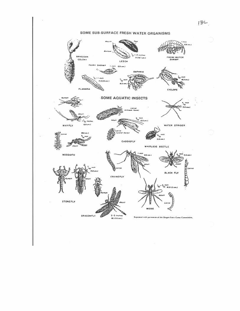
water shortages almost every summer. Point source water pollution means the contaminant comes from a discrete, identifiable point like a discharge pipe or ditch. Nonpoint source (NPS) pollution, in contrast, comes from a broad area like a parking lot, subdivision, construction site, forest or farm. The impacts can be seen but identifying the source is much more difficult. Point sources have been fairly well controlled. The bigger challenge now is to better control NPS pollution. Some NPS sources, such as highway construction can be regulated, others, such as subdivisions, farms and forests are impossible to regulate with any realistic monitoring program. In recognition of the practical impossibility of regulation, agriculture and forestry are exempt from regulations in Tennessee law. Controlling pollution from these, other non-point sources like subdivisions, depends on voluntary action supported by education, technical assistance and government cost sharing for some control measures. http://www.conservewater.utah.gov/Tips/ - Water conservation ideas. http://www.cityofbremerton.com/content/sw_waterpollutionfacts.html - Pollution prevention. http://www.epa.gov/owow/nps/whatis.html- Gateway to EPA information 5. Identify Common Aquatic Organisms Using a Key. Collecting and identifying aquatic organisms found in a water body is one of several ways that can be used to assess water quality.
The concept was applied to air quality by miners who took canaries into deep mines with them. If the canary died, the miners knew the air was bad and they had to evacuate the mine.
Like the canaries, aquatic organisms are subject to the conditions in their environment. If pollution levels reach a critical concentration; certain organisms will move away, die or will not reproduce. Eventually the species will disappear from the polluted site; normally they will return if conditions in the system improve.
In order for the analysis of the water quality to be accurate, the organisms must be identified correctly. Scientists use keys to help them do this.
http://www.sosva.com/ModifiedBugIDCardoct2004.pdf - information on some common organisms. 6. Watershed Systems
A watershed is the land area from which water drains to a particular watercourse or body of water. Watersheds are usually made of many smaller watersheds that contribute to overall stream flow.
Adjacent watersheds are separated by a high area of land called a divide. As an example, the Continental Divide in the Rockies separates the Mississippi River watershed (which includes Tennessee) and the Columbia River watershed. The Mississippi River Watershed is made up of smaller watersheds including the Tennessee River and Cumberland River watersheds. Each of these can be divided into smaller watersheds by focusing on smaller and smaller watercourses. A watershed can be as large as the Mississippi River drainage basin or as small as a backyard.
The watershed concept is a useful way to divide land areas according to how the land and the water flowing over and through it interact. Land and water are linked directly by the water cycle in a watershed. A watershed is thus a functional unit when considering how climate, plant cover, soil type, slope, geography and human activity affect water quality and quantity. Water is critically impacted by everything that goes on in a watershed.
To learn how to use a topographic map and delineate a watershed, go to http://www.nh.nrcs.usda.gov/technical/Publications/Topowatershed.pdf 7. Different Types of Aquifers and Their Relations to Water Quality/Quantity. An aquifer is an underground layer of rock, gravel or sand which stores and carries water. The water in the aquifer is called groundwater. The upper limit of an aquifer is called a water table. The spaces between the rock, sand, or gravel below the water table are saturated, that is full of water. Above the water table, the spaces are partly filled with water and partly filled with air. The water table drops as groundwater is removed and rises as groundwater is recharged. Groundwater moves from areas of higher pressure to areas of lower pressure. Speed depends on the properties of the rock or sediment; rates are typically feet per day but vary from only a few inches a year to several feet an hour. Flow generally follows surface topography, moving down slope. A common misconception is that groundwater exists in underground rivers (e.g. cave systems where water flows freely underground). This is only sometimes true in limestone areas, known as karst, which make up only a small part of the Earth's surface. Much more usual is that the pore spaces of rocks in the subsurface are simply full of water — like a sponge — which can be pumped out and used in agriculture, industry or municipalities. Karst (limestone terrain) is found in middle Tennessee. Sinkholes, formed when a cave roof collapses, are common in karst areas. A sinkhole may be open all the way from the surface to the aquifer; a contaminant entering the sinkhole can travel directly to the aquifer and pollute the groundwater. There are two major types of aquifers, unconfined and confined. Unconfined aquifers are sometimes also called water table aquifers, because their upper boundary is the water table surface. Typically (but not always) the shallowest aquifer at a given location is unconfined, meaning it does not have a confining layer between it and the surface. Unconfined aquifers usually receive recharge water directly from the surface, from precipitation or from a body of surface water (e.g., a river, stream, or lake) which is connected to it. In dry periods, water may move from an unconfined aquifer to a surface water body and maintain stream flow; this is called base flow. Confined aquifers have a layer of clay or rock above their upper boundary that restricts or prevents the movement of groundwater. They are typically found below unconfined aquifers A diagram can be found at http://ga.water.usgs.gov/edu/earthgwaquifer.html Go to http://capp.water.usgs.gov/GIP/gw_gip/index.html for information about groundwater. 8. Wetlands Wetlands are areas of land that are wet at least part of the year. They are often transition zones between dry land and open water. Some wetlands are covered with water year round while others are flooded only at certain times. All wetlands do have water soaked soil at some time during the year which affects the kinds of plants and animals found there. Wetlands provide unique habitats for many plants and animals. Many species depend on an aquatic or semi-aquatic environment. Changing the wetlands habitat displaces these plants and animals. For others, wetlands provide important habitat during part of their life cycle. These include birds such as ducks and geese, insects such as dragonflies and mosquitoes, amphibians such as frogs and toads and reptiles such as turtles and snakes. Some wetlands help control and maintain stream flow by slowing and storing water during periods of high flow and releasing it slowly during low flow periods.
Wetlands can also contribute to groundwater recharge. Water retained in wetlands slowly percolates into the ground. Wetlands are good water filters. They can filter surface water runoff before it reaches an open body of water and also help filter nutrients, wastes and sediment from floodwaters. Wetlands are found in all parts of the world and are classified into many types. There are fresh water and salt water wetlands. Examples of fresh water wetlands are swamps, marshes, bogs and prairie potholes. Salt-water wetlands include mangrove swamps and salt water marshes. Traditionally, wetlands have been regarded as useless, muddy, smelly, insect infested areas that needed to be drained and filled in so they could be used for something important. During the past 200 years more that half of America’s wetlands have drained and/or filled to use for purposes such as agriculture and real estate development. Wetlands contributions are just being realized. New regulations are protecting wetlands and regulating the way they are used. Debates about wetlands issues and conflicting land uses, including private property rights, are often difficult to resolve to everyone’s satisfaction. http://www.epa.gov/OWOW/wetlands/vital/toc.html - EPA wetlands information. 9. Riparian Areas Riparian areas can be defined in several ways, but they are essentially the narrow strips of land that border streams, rivers or other bodies of water. Because of their proximity to water, plant species and topography of riparian areas differ considerably from those of adjacent uplands. Although riparian areas may occupy only a small percentage of a watershed, they represent an extremely important component of the overall landscape.
Benefits of riparian areas include:
1. Sediment Filtering 2. Bank Stabilization 3. Water Storage and Release 4. Aquifer Recharge
A healthy riparian system would have some or all these characteristics: 1.) High water table and increased storage capacity, 2.) Strong and productive plant communities, 3.) Good shade-Cool water, 4.) Good fish habitat-Good water quality, 5.) High wildlife habitat diversity, 6.) Vegetation and roots present that help protect and stabilize banks, 7.) Higher stream flows during dry periods. An unhealthy system would have some or all these characteristics: 1.) Low water table and decreased storage capacity, 2.) Sparse, unproductive plant communities, 3.) Little shade-Warm water, 4.) Poor fish habitat-Poor water quality, 5.) Little diversity in wildlife habitat, 6.) Little vegetation and few roots to help protect and stabilize banks, 7.) Reduced stream flows during dry periods.
Two sites for more information on riparian areas are:
http://www.americanrivers.org/site/PageServer?pagename=AMR_content_4626
http://en.wikipedia.org/wiki/Riparian 10. Describe the changes to the aquatic ecosystem based on alteration of the aquatic habitat. An ecosystem is a community of plants, animals, and other organisms (like bacteria and viruses) interacting with one another and with the chemical and physical factors in their environment. Ecosystems can be of any size (a watershed, or a river, or a pool in a stream, for example). The boundaries are defined by the observer to suit her or his purposes, for example, to study fish species in a particular section of a stream or in an entire river system. Ecosystems are not necessarily stable, change is unavoidable in nature. Also, all the species in an ecosystem are not necessarily native to the area. Changes in plant or animal communities or in the non-living environment create change in an ecosystem. An aquatic habitat is a body of water where organisms live. Freshwater habitats include ponds, lakes (natural and man-made), streams and wetlands. There is great diversity in the aquatic habitats across Tennessee: Reelfoot Lake, 35 major reservoirs, more than 175,000 ponds, some 750,000 acres of wetlands, and over 60,000 miles of warm water and coldwater streams. Each of these freshwater environments has its own particular plant and animal inhabitants although there is some overlap. Some species are common to all.
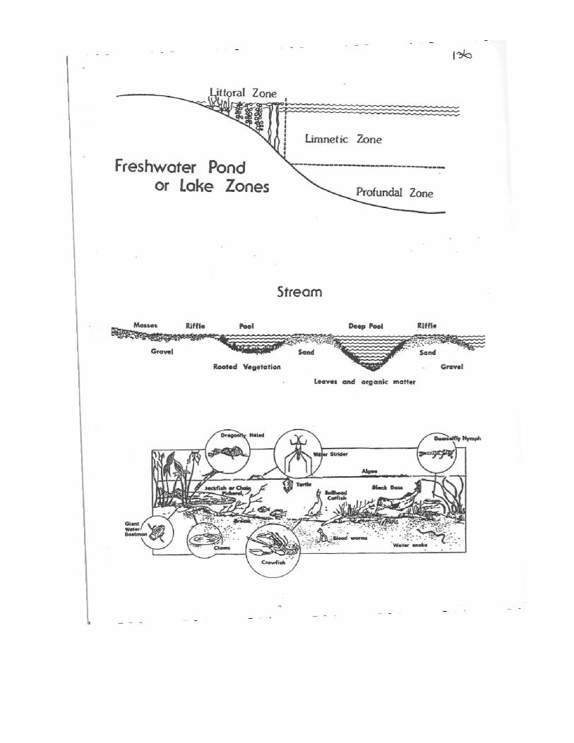
Freshwater habitats may be considered in two broad types. Standing water or lentic habitats include lakes, ponds and wetlands. Running water or lotic habitats include springs, smaller streams like brooks or creeks, and rivers.
Ponds. What life is found in a pond? A very important and probably most abundant type would be the phytoplankton or microscopic plants. The entire life of the pond depends upon these tiny plants to supply food and oxygen.
On the pond edge and extending out into the water are rooted plants growing from bottom. There are zooplankton (microscopic animals) which consumes phytoplankton and larger animals like snails and insect larvae which feed on the plants. Animals such sunfish at various stages of development feed on zooplankton, insects, snails, and smaller fish. Finally, predator fish such as largemouth bass feed on the sunfish.
Streams generally have two major zones and the plant and animal life present is determined by how fast the water flows. The rapids zone has shallow water where current velocity is great enough to keep the bottom clean of silt and other loose materials. The pool zone has deeper water where current velocity is reduced and silt and other loose materials settle to the bottom. The current velocity varies from stream to stream and within the stream itself; and depends upon the size, shape, and steepness of the stream channel, the roughness of the bottom, the depth, and the rainfall.
In the rapids only those plants and animals which can adapt to rapid currents are found. Included are plants such as mosses clinging to rocks, animals like damsel fly and dragon fly larvae and fishes such as trout, shiners and darters which hide under rocks and plants on the bottom. In the pools you find rooted vegetation and small animals–snails, crayfish, aquatic insects, bloodworms – on the stems and leaves. Larger animals found here might be bullhead catfish, pickerel, sunfish, and bass–essentially the same forms as are found in lakes and ponds.
A stream flows in a channel. Channel size is determined by the amount of stream flow, the texture of the soil in which the channel is cut and the shape of the channel. Stream habitats can be classified in several ways such as cascades, falls, pools, plunges, runs, and riffles or main channel, side channel, embayment and backwater. Stream flow is made up of base flow and runoff. Base flow comes from groundwater and is relatively consistent throughout the year. Runoff from rainfall adds to base flow. It varies during the year depending on storms and seasonal conditions. The amount of runoff reaching a stream depends on many other factors including type of soil, how much water the soil contains, the rate of rainfall, the slope of the land and amount of impervious manmade structures like roads, buildings and parking lots.
Sometimes so much water is carried by a stream that it overflows its banks and floods. A floodplain is a broad, flat surface in the valley of a stream that is at least partially flooded each year. Much fertile farmland is located on flood plains which are composed of sediment carried by streams and deposited during floods. We built our towns in flood plains in part because the flat surface and water deposited soils are good building sites and in part because we use rivers for transportation, drinking water sources, waste disposal, and other ways. We change streams with dam, levees, and channelization to solve flooding and other problems. But, in solving one problem another is often created. There are no easy solutions.
Aquatic life can be classified and studied in many different ways. Plants, of example, can be divided into submergent, floating and emergent types. Animals can be divided into vertebrates and invertebrates.
Other useful ways include –
A. According to their scientific classification (family, genus, species)
B. According to their place in the food chain:
Producers – Phytoplankton and other plant life.
Consumers –
1. Feeders on phytoplankton
2. Feeders on zooplankton
3. Feeders on larger invertebrates and small fish.
Decomposers – Feeders on decaying matter
C. According to their life habitat:
Benthos – organisms living on the pond bottom.
Periphyton – organisms attached or clinging to plants or other objects.
Plankton – floating organisms.
Nekton – swimming organisms.
Neuston – surface organisms.
D. According to their habitat within the pond:
Littoral zone – shallow water area in which light penetrates to the bottom.
Limnetic zone – open water to the depth of light penetration.
(The Euphotic zone comprises the littoral and limnetic zones).
Profudal zone – area beyond depth of light penetration.
Alterations in the aquatic habitat may be • physical -addition of abnormally hot water into a stream, for example • chemical -introduction of a toxic material at concentrations harmful to organisms, for example • biological- introduction of a non-native plant or animal, for example
The watershed also affects an aquatic habitat. For example, because of characteristics of the watershed the flow in a stream may change dramatically when it rains. Heavy storms may cause streams to rise rapidly. Human-made features in a watershed like large paved areas or dams alter the watershed, change stream flow and impact aquatic habitats. In other watersheds, stream flow may take a long time to respond to rainfall. In a relatively flat, heavily vegetated watershed, runoff is slowed by the plants and much of it soaks into the ground. The runoff will eventually make its way through the watershed and become stream flow. Streams will rise slowly and also recede slowly Streams start at higher elevation and flow downward, eventually finding their way to the sea. But they don’t travel in straight lines. Their paths vary. The land may be steep in some areas, causing rapid stream flow, and flat in other areas allowing the water to spread out and get deeper. These grade changes create different habitats in the stream which support different forms of life. Many other watershed characteristics create different aquatic habitats. For example because of geology, many East Tennessee streams are rock
bottomed while West Tennessee streams are mud bottomed. Aquatic habitats are critically impacted by everything that goes on within the watershed. Mining, forestry, agriculture, industry, construction practices, urban runoff from streets, parking lots, lawns and gardens, failing septic systems an improperly treated municipal sewage discharges all affect aquatic habitats. Changes in the aquatic ecosystem based on habitat alterations may include:
• The loss of species. • The accelerated proliferation of organisms. One example is algae blooms caused by an excess of phosphorous or nitrogen in the water. This condition is called "eutrophication". • Increased incidences of tumors or deformities in fish and animals. • A change in chemical properties. One example is a reduction of pH in water caused by acid rain. • A change in physical structure. A stream channel becoming deeper and wider because of
increased flow or a pond filling with silt and becoming a wetland are examples. • The loss of traditional human cultures or customs associated with the ecosystem.
Habitat alteration is not just done by humans. Natural processes can significantly change habitat; for instance, a fire caused by lightening in a riparian forest can eliminate stream-side shade and increase water temperatures, harming organisms dependant on cold, oxygen-rich water. Animal species can also substantially change habitat to accommodate their specific needs; the beaver is a good example. More information on aquatic ecosystems can be found at http://chamisa.freeshell.org/ecology.htm 11. Methods to assess and manage aquatic environments. Using water quality information to assess the water quality of a specific body of water. This includes sampling technique and parameters used to monitor point and nonpoint pollution. There are many ways to study aquatic habitats. Using different methods can give us a broader picture of the water body and a better understanding of the relationships in it. Physical, chemical and biological information can help us assess an aquatic habitat.
Physical Information We can learn a lot through observation. The numbers and kinds of plants and animals we see are indicators of the “health” of an ecosystem. Some are very sensitive to pollution, for example. Seeing them is an indication of an uncontaminated habitat.
Turbidity is caused by suspended materials like algae, silt and pollutants. A “healthy” habitat has enough algae to provide food but not enough to become a problem. Turbidity can be measured with a Secchi disk. Observations in the watershed can help identify sources of eroded soil and other materials that cloud water.
Temperature is an easily measured and very important physical characteristic. It affects the amount of dissolved oxygen (DO) water can hold. Temperature also affects feeding, reproduction and metabolism of aquatic organisms; these rates speed up as temperature increases.
The surface area and average depth of a pond or lake are important in calculating the amount of water it contains for management decisions like fertilization for fish production or aquatic weed control.
Stream width and depth are similarly used to calculate volume. How fast the stream flows is combined with its volume to estimate flow volume; that is, how many gallons per minute (or second or day) flows in the stream. Water resource managers also use this information in their decisions.
Topographic maps can be used to identify the watershed divides and calculate the areas in the watershed. These maps, aerial photographs, satellite images and field observations help understand the watershed’s characteristics and activities which can impact the aquatic habitat.
Finally, looking at characteristics of a water body can help our understanding: color, odor, unusual surface sheen, form or unused materials on or in the water are all clues to the quality of the habitat. Large amounts of algae, for example, may indicate extra nutrients are entering the water from some source. An oily, rainbow sheen on the surface and a gasoline smell may indicate a leaky fuel storage tank or other source is polluting the water body.
Chemical Information
Literally thousands of natural and manmade chemicals exist in today’s world. With enough time and money a water body could be tested for every one of them. But, this would be very expensive and time consuming and most of the chemicals would not be found. Toxic chemicals are only a single factor in the water chemistry component. The wiser course is to focus on key variables – DO, pH, hardness, nutrients and metals. The importance of these variables changes with the intended use of the water. For aquatic life, for example, DO and pH are very important but nutrients may be equally important. Physical factors like temperature and turbidity are also important for aquatic life. Focusing on only one or two variables can give us an incomplete, distorted view of the quality of a particular pond or stream.
Tests for other chemicals are typically done only if the chemical is suspected to be in the water. For example, if contamination from a pesticide is suspected, a test for that pesticide is made.
A broad screening test for volatile organic carbon compounds (VOCs) found in petroleum products, cleaning fluids and other common chemicals, is often done if human related pollution is suspected. Finding VOCs indicates contamination from human-made chemicals.
Water chemistry also depends to some degree on the physical characteristics of the water body and watershed. The flow of a stream, for instance, might vary by a factor of fifty or more depending on the time of year. Chemicals in the water are diluted by the greater volume of water during high stream flows making detection more difficult. Flow volume calculations are used to determine chemical concentrations as so many parts of the chemical per volume of water, parts per million or milligrams per liter for example.
Also, since the greater stream volume is due to storm runoff, high flows from urban areas usually carry large amounts of metals and petroleum products from streets and parking lots into the stream. This especially true for the first part of the runoff, the “first flush.”
High flows also usually have high turbidity due to erosion from unvegetated land in the watershed during the storm.
Biological Information
This approach used the organisms living in the aquatic system to examine water quality. The concept was applied to air quality by miners who took canaries into deep mines with them. If the canary died, the miners knew the air was bad and they had to evacuate the mine.
Like the canaries, aquatic organisms are subject to the conditions in their environment. If pollution levels reach a critical concentration; certain organisms will move away, die or not reproduce. Eventually the species will disappear from the polluted site; normally they will return if conditions in the system improve.
Three general components affect a biological community in an aquatic ecosystem:
(1) hydrology – water depth, velocity, duration of standing water
(2) chemistry – DO, pH, nutrients, toxic materials
(3) geomorphology – bed material, bank stability, shifting sandbars, physical habitat These components impact the biological community alone and together. Their relative importance may change with time and location. At times, a single factor may dominate. For example, straightening a stream and removing all the woody debris drastically alters the stream’s geomorphology. The impact includes loss of natural habitat and shelter for certain organisms. The organisms that require this habitat will disappear from the modified stream. Separating the influence of one component from the others is difficult. Considering all these components and their interactions is critical when interpreting biological information.
Selecting the organisms to study is a key part of a biological investigation. We want organisms appropriate for the water body and the contamination being investigated. Alternatives include:
� bacteria – certain bacteria indicate contamination by human or animal waste � algae – exceptionally rapid growth is an indication of nutrient enrichment. � aquatic plants – death during the growing season may indicate herbicide contamination or turbidity blocking sunlight. � zooplankton – microscopic animals are affected by toxins, turbidity and nutrient enrichment. Their short life cycle provides a quick response but their microscopic size makes them difficult to collect and study. � macroinvertibrates – often used as indicators because different species have distinct sensitivities to pollutants. They are also sensitive to hydrology and geomorphology. � fish – good indicators since they rely on the other organisms for food and thus, they mirror the overall health of the entire food chain. Spotty distribution can limit usefulness. Sampling methods depend on the organism. They include hand picking organisms off stones or twigs, nets, scoops and sieves, artificial habitats and electroshocking. Data on fish populations can also be collected through creel surveys and interviewing fishermen and women.
Biological information is analyzed with a number of statistical methods; usually the total number of organisms and the number of species in the sample will be determined. This information can be compared with an index that lists organisms according to their sensitivity to pollution.
Biological information measures the environmental effects of water quality. But, seeing the effects does not necessarily tell us what has caused the change. Physical and chemical information may be needed to help identify what is changing the water quality. Monitoring Strategy. Monitoring strategy – how, when and where information will be collected – is an important factor in assessing aquatic environments. Four strategies are (1) single sample, (2) trend analysis, (3) upstream-downstream, and (4) paired watershed. Each one has its own benefits and limitations. Your objectives, specific site characteristics, funding, and time available enter the decision on which approach to use. More than one strategy might be used to overcome limitations of an approach. Single Sample. One sample is taken for analysis. Benefits: Relatively quick and inexpensive snapshot of water quality. Can be useful in a preliminary reconnaissance of a water body. Can pinpoint a specific pollutant or polluter; for instance, a single sample may be taken to investigate a problem such as verifying a pollutant spill in a pond. Limitations: The information only reflects conditions at the exact location and time when the sample was taken. Trend analysis. Samples are taken at the same locations and analyzed with the same techniques over time. Benefits: Provides information on changes in water quality over time. Can be useful in determining improvements in water quality because of changing management practices; implementing
conservation practices on farms or improving a waste treatment plant, for example. Limitations: Difficult to see significant changes in water quality over time in large watersheds because of the variability due to natural events. Also, it may require years for a contaminant to leave an ecosystem; for example, it may take decades for nitrogen entering a stream in groundwater to show any decline even if no additional nitrogen fertilizer is applied in the watershed. Many years of data may be needed to show a significant change in water quality. In addition, other changes in the watershed over time may mask the effects of the management change you are studying. Running a paired watershed study at the same time may help overcome these problems. Upstream-downstream. The quality of water entering a location is determined to define a baseline condition. Then, water quality is again determined after it has traveled through the location of interest (past a factory, a landfill, a farm, a forest, or a wetland, for example). Benefits: Changes in water quality that are the result of the facility or location of interest can be determined. Limitations: The stream may have other inputs of water (springs, tributaries, ditches) which affect water quality. All inputs must be considered before inferring cause and effect. Difficult to use in stream backwaters or in lakes. Paired watershed. Two watersheds with similar features are compared to determine differences in water quality as a result of differences in land use or other characteristics. A watershed with little of no human activity may be used as a reference to estimate the best water quality possible in the watershed being studied. Benefits: Good for comparison purposes. Limitations: Difficult to find two watersheds that are similar in all ways except the one factor being evaluated. Likewise, it is often difficult to find a comparable “natural” watershed to use as a reference. Is a pond or stream “healthy”? When aquatic biologists study a pond or other water body they look at characteristics of the habitat to assess its “health.” These would include (1) the amount of DO (2) algal content (enough to provide food but not enough to become a burden itself) (3) fish population and health, (4) the population and diversity of insect larva, shellfish, worms and other invertebrates and (5) the kinds and amounts of pollutants in the mud on the bottom of the pond. These characteristics are also used in assessing streams. Many of the methods used to study a pond community can be applied to the study of a stream; but here are certain differences which must be kept in mind:
1 Due to its shallower depth and mixing of water, certain environmental conditions such as temperature, light, and oxygen supply are much more uniform in a stream than in a still body of water. 2 For the same reasons, the oxygen content of a stream is usually higher than that of a lake or pond. Stream organisms are less tolerant of a decrease in oxygen level, and are therefore greatly affected by organic matter pollution which uses up oxygen in its decay. Changes in the organisms of a stream community often indicate the presence of pollution. 3 Streams usually have fewer producers than lakes or ponds. For this reason they are more dependent on surrounding land areas for input of organic material to provide food for consumers. 4 Current (rate of stream flow) is a major environmental factor. To measure stream flow rates using a fishing bobber, place stakes in a free flowing area of the stream (5-10 feet distance is usually enough). Record the number of seconds required for the bobber to travel between the markers. Repeat several times, calculate the average and convert to feet per second. http://www.nrcs.usda.gov/technical/ECS/aquatic/svapfnl.pdf - Visual assessment handbook http://tennessee.gov/environment/wpc/publications/2006305b.pdf - How Tennessee monitors is outlined on pages 19-28.
12. Major methods and laws used to protect water quality. How is this used to make management decisions to improve water quality in a given situation?
Water Quality Standards
Water has different quality standards depending on its intended use. Water may be pure enough for livestock to drink but not be high enough quality for humans to drink. Or, water may be fine for bass, bluegill and other lake fish but not have enough oxygen to support trout. Water quality is often in the “eye of the beholder.”
Under the Federal Water Pollution Control Act (Clean Water Act) standards are based on two key factors; stream use classification and the level of water quality needed to support a designated use. Stream use classifications include:
• Domestic water supply
• Industrial water supply
• Fish and aquatic life
• Recreation
• Irrigation
• Livestock watering
• Wildlife
• Navigation
Streams may be divided into segments (or reaches) with a different set of uses established for each segment. Different designated uses dictate different levels of water quality. Physical and chemical criteria are used to assess the quality of the water, including: • Dissolved oxygen • pH • Hardness • Total dissolved solids • Floating material, solids, deposits • Turbidity • Temperature • Fecal bacteria (bacteria from animal or human waste) • Taste and odor • Toxic substances • Other pollutants The criteria used depend on the designated uses of the water body. To evaluate drinking water quality, all eleven are used but only seven are used to evaluate a stream designated for livestock and wildlife uses. The standards for individual criteria may also vary with different uses. A trout stream requires 6 ppm DO, for example, while 5 ppm is sufficient for other fisheries and allowances may be made down to 3 ppm DO.
States are required to report on surface waters that meet and do not meet the criteria for designated uses every two years. This report, called the “305b report” for the part of the Clean Water Act – section 305b – that requires it, is a fundamental source of water quality information. The Tennessee Department of Environment and Conservation prepares the 305b report in our state.
The Safe Drinking Water Act sets maximum levels for a variety of chemicals, metals and bacteria. It
also sets treatment requirements, monitoring criteria and public notification requirements. The 1996 reauthorization included a requirement that public water systems regularly report monitoring results to their customers.
Water Quality Monitoring
Monitoring depends on stream use, land management and state or federal regulations. Under the Clean Water Act, the owner or operator of a facility covered by a National Pollution Discharge Elimination System (NPDES) permit is required to monitor effluent or waste water quality at regular intervals, maintain records and report results. Regulators can also monitor water quality at these sites to determine compliance with permit requirements and notify the owner or operator of any violations. States must have adequate monitoring programs to be eligible for federal funding.
Effluent or wastewater covered by a NPDES permit is one example of “point source” water pollution meaning the contaminant comes from a discrete, identifiable point like a discharge pipe or ditch.
“Nonpoint source” (NPS) pollution, in contrast, comes from a broad area like a parking lot, subdivision, construction site, forest or farm. The impacts can be seen but monitoring and identifying the source is much more difficult.
Other water quality monitoring includes:
• monitoring by drinking water plant managers.
• monitoring by industrial plan operators if changes in water quality have adverse effects on operations.
• monitoring by farmers or forest managers to verify the effectiveness of their management practices.
Monitoring can include on-site physical measurements or chemical tests, laboratory analysis, field observations of plant and animal life and collecting aquatic organisms for field or laboratory analysis. One or more of the strategies discussed in section 11 may be used – single sample, trend, upstream-downstream, and paired watersheds.
Water Quality Management
Many different methods are used to improve water quality. A number of physical practices are used. Examples include:
*Cooling towers at power plants and factories to reduce temperature of water heated in the plant.
*Silt fences and straw bales at highway and other construction sites to filter out sediment.
*Filters at drinking water plants to remove sediment and larger microorganisms.
Many chemical treatment practices are used in industry to remove contaminants in water to be used in the plant as well as in wastewater. Other examples include:
*Chlorine treatment in drinking water plants to kill microorganisms.
*Softening hard water by exchanging calcium and magnesium ions for sodium or potassium ions in a home water softener.
*Raising the pH of acid mine drainage with buffer treatment systems.
Biological methods are also used in some situations. Examples include: *Planting trees, shrubs and grasses in riparian areas to stabilize stream banks, filter out silt, and
slow the flow of surface water into streams. *Using plants in constructed wetlands to treat wastewater. Pollution Prevention is an alternative to cleaning up pollution after it has occurred. Prevention is often cheaper, easier and more successful than clean-up. It may be very difficult, if not impossible, to clean groundwater contaminated with pesticides, for example. Preventing the contamination with wellhead protection measures and other recommended practices is a good alternative. Many industrial practices are based on pollution prevention. In agriculture and forestry, best management practices (BMPs) allow the production of food, fiber and wood products in ways that prevent water pollution.
We can all play an effective role in preventing water pollution. Careful use of lawn and garden chemicals, recycling used motor oil and other possible contaminants, keeping trash out of sinkholes and other sensitive areas and reducing our water consumption can all have a big impact on pollution.
http://tennessee.gov/environment/wpc/publications/2006305b.pdf - Tennessee’s 2006 305b report. Includes information on standards and laws. http://tennessee.gov/environment/wpc/ - Homepage for the Tennessee Department of Environment and Conservation Division of Water Pollution Control. Links to many sources of information. Sources: In addition to the web pages listed, Envirothon materials from Georgia, North Carolina, New Jersey and New York were used in developing this study guide. The work of Dr. Thomas K. Hill, retired fisheries specialist with University of Tennessee Extension, was also instrumental.
Sample Questions
1. The major types of aquatic environments in Tennessee are (circle all that apply):
� a. Standing water or lentic � b. Underground lakes or streams � c. Running water or lotic � d. All of these. 2. Phytoplankton is:
� a. Microscopic plants. � b. The foundation of the freshwater food chain. � c. A source of oxygen in aquatic habitats. � d. All of these. 3. What organisms indicate good quality water?
� a. Stoneflies, crayfish, and snails. � b. Dragonflies, crayfish and snails. � c. Stoneflies, caddis flies and may flies. � d. Stoneflies, caddis flies and aquatic worms.
4. Producers, consumers and decomposers are:
� a. Found in all aquatic environments. � b. Terms that describe an aquatic inhabitant’s place in the food chain. � c. Not found in cold water streams. � d. Resistant to water pollution. 5. What factors limit all aquatic environments?
� a. Sunlight, oxygen, temperature and nutrients. � b. Sunlight, oxygen, nutrients and stream flow. � c. Salinity, oxygen, temperature and nutrients. � d. None of the above 6. Trout prefer the following habitat:
� a. Fast flowing streams. � b. Cold water streams. � c. Slow moving, large rivers. � d. Both a and b. 7. These trout are native to Tennessee (circle all that apply):
� a. Rainbow Trout. � b. Brown Trout. � c. Brook Trout. � d. Goldeneye Trout. 8. Fish with tubular, streamline bodies and strong pectoral fins are common in:
� a. Fast flowing streams. � b. Lakes and ponds. � c. Large, slow flowing rivers. � d. Coral reefs. 9. Green or brown pond water may indicate:
� a. Fast flowing streams. � b. Hard water. � c. Good carbonate/bicarbonate balance. � d. An over-shaded pond. 10. A balanced pond community managed for fishing is indicated by:
� a. Many intermediate bluegill, tadpoles, crayfish and minnows. � b. Young largemouth bass, many recently hatched bluegill, few intermediate bluegills. � c. Young largemouth bass, no recent bluegill hatch, but many intermediate bluegills. � d. Many adult largemouth bass. 11. Managing a pond for fishing involves:
� a. Construction and stocking. � b. Fertilization. � c. Fish harvest. � d. All of the above.
12. Bioaccumulation is:
� a. The accumulation of organic matter in a pond. � b. The increased concentration of a substance in an organism through the food chain. � c. The build-up of nitrates in fish due to agricultural run-off. � d. The gradual filling-in of ponds and lakes with decaying organic matter. 13. Wetlands:
� a. Are covered with water year round. � b. May help regulate and maintain the hydrology of rivers. � c. Provide important fish and wildlife habitats. � d. Are only found in freshwater environments. 14. All wetlands have water-soaked soil at some time of the year which affects the kinds of plants and animals found there. True or False 15. A single stream or body of water may contain a number of different habitats. True or False 16. An aquatic habitat may change over time due to natural processes or human influence. True or False 17. Conditions are more uniform in a still body of water than in a flowing stream. True or False 18. Oxygen content in a stream is usually about the same as in a nearby lake or pond. True or False 19. One problem with fertilizing a pond is increased mosquito populations. True or False 20. A Secchi disc is used to determine the depth of light penetration in a body of water. True or False Answers: 1. a and c 11. d
2. d 12. b
3. c 13. b and c
4. b 14. True
5. b 15. True
6. d 16. True
7. c 17. False
8. a 18. False
9. a 19. False
10. b 20. True