Embed Size (px)
Citation preview

Volume 28, Number 1 January, 2008Volume 28, Number 1 January, 2008
THE ALASKAN CAVERTHE ALASKAN CAVERSPECIAL EL CAPITAN CAVE ISSUESPECIAL EL CAPITAN CAVE ISSUE

Back cover: “They came out of El Capitan so clean this time!”. From left: Kevin Allred, Mira Wilhelm, Josiah Huestis, Samantha Barnes, Billy White and Taira Wilhelm. Photo by C. Allred.
Front cover: Samantha Barnes rappels down Twin Pits in El Capitan Cave, Prince of Wales Island. Photo by Carlene Allred
A Focus on... El Capitan Cave, by Liana Boop -------------------- page 2El Capitan Cave Photo Gallery ---------------------------------------- page 6An Autumn El Capitan Cave Adventure, by Tiara Wilhelm ----- page 7A Pictorial Account of the Mapping of El Capitan Cave --------- page 9Rope Cutter ---------------------------------------------------------------- page 11Caving Group Gets Together on POW ------------------------------ page 13Map of El Capitan Cave ------------------------------------------------- page 14
The Alaskan Caver, Volume 28 No. 1 page 2
(continues on page 3)
TABLE OF CONTENTS
INTRODUCTION
During the summer of 2007, I accepted an Internship through the Student Conservation Association (SCA) where I worked with the United States Forest Service giving guided tours of El Capitan Cave. Located in the Tongass National Forest on Prince of Wales Island, Southeast Alaska, El Capitan Cave is Alaska's largest and only show cave, with over two miles of mapped passage.
At the beginning of the tour, visitors were given helmets and flashlights at the base of a 370 step staircase, which was the ascent to the cave. Rest stops were taken frequently to talk about some of the features of the temperate rainforest, including natural disturbances (overturned trees from wind and snow events), native flora (trees, ferns, berries), culturally modified trees (scars left from bark stripping hundreds of years ago), and visible epikarst, the features of a carbonate bedrock where it meets the surface.
DEFINING SOUTHEAST ALASKA'S KARST
One of the most challenging parts of the tour was explaining the history of El Capitan to our visitors. At the start of the tour, I held a shell, and asked if anyone had ever been in a cave before. Some people, when asked, knew that caves are made of limestone (or marble). Limestone and marble are both carbonate rocks, I explained, which is why I was holding the shell. People have a hard time grasping that something that was once a tropical reef is now 360 feet above sea level, in Alaska.
The history of El Capitan Cave extends more than 400 million years back in time. According to Baichtal and Swanston (1996), the Heceta Limestone
By Liana M. Boop 15 November, 2007
A FOCUS ON ONE OF SOUTHEAST ALASKA'S BURIED TREASURES:EL CAPITAN CAVE, PRINCE OF WALES ISLAND:
THE ALASKAN CAVER
EDITOR: Carlene Allred2525 4th AveKetchikan, Alaska 99901hm: 907 [email protected]
GLACIER GROTTO OFFICERS
PRESIDENT: David LovePO box 240812Douglas, AK 99824-0812
VICE PRESIDENT: Kevin Allred2525 4th AveKetchikan, Alaska 99901
SECRETARY/TREASURER:Rebecca Valentine11976 N. TongassKetchikan, AK 99901
CONSERVATION: Steve LewisBox 53Tenakee Spr., AK [email protected]
CAVE RESCUE: Gary SonnenbergPO Bos 22555Juneau, AK 99802
TONGASS CAVE PROJECT:
Steve LewisBox 53Tenakee Spr. AK [email protected]
Kevin Allred2525 4th AveKetchikan, AK 99901hm: 907 [email protected]
Pete [email protected]
THE ALASKAN CAVER (ISSN 0735-0481) is the periodic publication of the Glacier Grotto of the National Speleological Society (NSS).
Back issues are available from the Glacier Grotto secretary for $2.50 each. Materials not copyrighted by individuals or by other groups may be used by NSS publications provided credit is given to the author and to The Alaskan Caver. Opinions are not necessarily that of The Alaskan Caver, the Glacier Grotto or the NSS. The editor welcomes contributions such as letters, trip reports, cave reports, photos, cartoons, stories, cave maps, etc.
Annual dues are $15 per individual and $20 per family or organization. The Alaskan Caver is included in the membership fee. For an additional $8, six The Alaskan Cavers will be sent overseas via airmail. Send dues to the treasurer.

Figure 2: Limestone meets the surface, showing features of epikarst along the trail to El Capitan Cave. The cracks are natural jointing, which roots take advantage of. These joints are conduits for water to move through, into the subsurface environment. Photo by Liana Boop.
Figure 1: Marine fossils can be found in specific locations within El Capitan Cave. Photo by E. Bennett.
The Alaskan Caver, Volume 28 No. 1 page 3
Formation, which contains El Capitan Cave, was portion of Prince of Wales Island and found that the deposited near the equator during the Silurian, between percent CaCO ranged from 92 to 99%, and that the 3
438 and 408 million years ago. Limestone is formed in average was 98%. Particles that are not calcium shallow, tropical marine environments, as evidenced by carbonate may be sand, clay, or pebbles, which serve as the fossils found in the Cave (Figure 1). Blatt, Tracy and the impurities in the limestone.
Cavities in limestone form when the calcium carbonate reacts with carbonic acid in rainwater. Carbon dioxide, CO , occurs naturally in Earth's 2
atmosphere. It combines with rainwater, H O to form 2
carbonic acid, H CO , as reported in Ritter, Kochel and 2 3
Miller (2002). Elliot (1994) states that between 60 to more than 250 inches of rain fall on southeast Alaska annually. The amount of available rain, coupled with the purity of the limestone, provides the potential for huge cavities to form underground, as well as very well developed karst features above ground.
Epikarst is the “highly solutional[ly] modified upper zone of the bedrock” (p. 10) according to Elliott (1994), whereas Baichtal and Swanston (1996) define it as “the saturated zones within the intensely dissolved veneers developed at the surface of carbonate rock sections, either beneath soils or on exposed rock outcrops” (p. 1). They continue: “deep shafts,
Owens (2006), state that warm water temperature is crevasselike dissolved fissures, erosion or dissolution needed to supersaturate the water in calcium carbonate rills, and spires and spikes of carbonate bedrock (p. 1)” (CaCO ), thus causing it to precipitate out, forming 3 are characteristic epikarst features (Figure 2). sediment rich in calcium carbonate. The water must also be relatively shallow, so that light can reach the sea floor. Calcium carbonate is essentially the remains of shelly animals, ranging from large coral reefs to barely visible forams. The water must be clear (free of suspended sediment), so as not to block sunlight. Filter feeders, such as corals, also need clear water. Shelly organisms thrive “in areas of abundant light, constant salinity, and clear warm water” (p. 192). Carbonate deposition does not typically occur near the input of large rivers, which carry mud sediments, and decrease salinity by introducing a large amount of fresh water.
Tectonic forces caused deposition to cease, and lithification to occur. Baichtal, Streveler and Fifield (1997) report that over the past 170 million years, many different terranes, including that which contains the Heceta Limestone, were accumulated as plates moved past each other. The Heceta Limestone, once turned into rock, journeyed from the South Pacific Ocean, where it was joined to southeast Alaska. It has since been carved away. The geologic history of southeast Alaska is
The limestone of southeast Alaska ranges up to complex, made only more complex by the several 99.5 % CaCO reports Elliot (1994). A study cited in 3 periods of past glaciations, which carve the landscape Baichtal and Swanston (1996) tested 67 carbonate and deposit sediments. Whereas water flows in thebedrock samples from karst areas on the northern (continues on page 4)
A FOCUS ON...EL CAPITAN..., continued from page 2

Figure 3: A typical muskeg as viewed from the Forest Service Beaver Falls Karst Interpretive Trail on Prince of Wales Island. In a muskeg, there is no definitive watercourse. The change in vegetation from primarily mosses and grasses to trees most likely indicates a subsurface change from an impermeable layer (such as glacial sediment) to a permeable unit, usually limestone. Photo by Liana Boop.
Figure 4: Soda straws are a special type of speleothem, or cave formation, named for their resemblance to a beverage straw. These stalactites (which hang from the ceiling) form very slowly; the drop of water at the tip of each soda straw deposits dissolved calcite on the ring as water slowly moves through the hollow middle. Photo by D. McCully.
(continues on page 5)
The Alaskan Caver, Volume 28 No. 1 page 4
cracks and fissures through limestone, compacted Large passages form when large volumes of glacial till and units of impermeable rock do not allow water carve over time, employing both physical for subsurface movement of large volumes of (mechanical) and chemical weathering. There are groundwater in defined channels. As shown in Figure 3, many different patterns that a cave can form in; these water pools on the surface above these impermeable are dependent on properties of the rock (purity, layers, creating bogs, locally referred to as muskegs. jointing) and height of the water table, as well as other
factors (Ritter et al., 2002). The frequency of karst features, on the other
hand, is dependent on the purity of the carbonate bedrock, and the acidity of the water. As the Heceta Limestone is very pure, and the water is strongly acidic, karst is highly developed in Southeast Alaska, especially in areas that have been less modified by glaciers (alpine and sub-alpine regions). Schulte and Crocker-Bedford (2002) report that over 875 square miles of karst exists in the vicinity of Ketchikan, Alaska (this includes Prince of Wales Island). Elliott (1994) estimates that some areas have sinkhole densities ranging from 3,000 to 10,000 per square mile, whereas southern Indiana has an estimated 1,122 per square mile. The initial drop of El Capitan Pit measures 598.3 feet for a total depth, including a ledge, of 624 feet (Baichtal 1994), which ranks it as one of the deepest in the United States.
Southeast Alaska's karst is highly developed because of the purity of the limestone, the acidity and the amount of water. The area is influenced by the Alaska current, which is driven by the Pacific Ocean's
Here, sphagnum mosses (and other varieties) Kuroshio Drift, which means that the average obrew rainwater to be even more acidic, down to 2.4 pH temperature is about 40 F (Schulte and Crocker-
(Baichtal and Swanston, 1996; Elliot, 1994). These Bedford, 2002). The temperature inside a cave reflectsmuskegs typically occur close to karst systems, so the acidic water does not have far to travel before it trickles into the subsurface.
While cave entrances and sinkholes are obvious karst features that water can flow through, the natural joints and cracks in bedrock introduce a large volume of the water that enters a cave. Igneous intrusions, fault planes, and other natural zones of weakness become the preferential route for water to flow along.
When the acidic water enters the subsurface, it reacts with the carbonate bedrock. Dissolved carbon dioxide in water dissolves the calcium carbonate, carrying it, in solution, until there is a drop in pressure, which is to say that the conduit opens. When pressure and velocity drop, the water loses its capacity to carry the dissolved material, so it precipitates out because of the loss of carbon dioxide. This is analogous to the bubbles formed from opening a soda can. Speleothems, or cave formations, form when dissolved calcium carbonate is deposited inside an existing passage (Figure 4).
A FOCUS ON...EL CAPITAN..., continued from page 3

Figure 6: The entrance to El Capitan Cave, located on Prince of Wales Island in Southeast Alaska. The Cave is at the top of a 1,300 foot long, 370-step-staircase. A gate, installed in 1993, is located about 150 feet inside. Photo by Liana Boop.
Figure 5: Map of the tour route of El Capitan Cave, by Carlene Allred. The tour route (the widest passage, from left to right) goes about 600 feet from the entrance of the cave.
amount of equipment that must be carried to the dive site. Further complicating cave diving is the silt that rests on the floors of flooded passages; once disturbed, the water clouds very quickly, making it very difficult for divers to navigate. For these reasons, only limited diving exploration has been used in El Capitan Cave.
The main entrance of El Capitan Cave (Figure 6), through which the tour enters, is not the only entrance. There are two
The Alaskan Caver, Volume 28 No. 1 page 5
the average temperature on the surface. Caves typically table; the Rockwell River flows, expanding the existing have very high relative humidity, and low air flow. Elliott passage. According to Allred (1998), the mapped (1994) states that because caves are cool and protected, vertical extent of El Capitan Cave is 428.6 feet, and many specimens, such as 7,000 year old logs and there is a total of 12,512.2 feet of mapped passage (El 30,000 year old bones that have been found in Capitan Pit is not known to connect to El Capitan southeast Alaska, are perfectly preserved. Cave). [Editor’s note: the total surveyed passage length
at the time of this publication is 12,644.9 feet]. Many EL CAPITAN CAVE passages on the current map end abruptly in question
marks, indicating that there is more to be mapped. Although karst landscapes exist throughout the
United States, my passion (and perhaps a bit of luck) brought me to El Capitan Cave. The Cave is unique because of the history contained within its rooms. Many distinctive formations decorate its walls, and there is a plethora of research pertaining to El Capitan Cave.
In the field of geology, some things cannot be directly dated. For example, it is not known when the passages in El Capitan Cave started forming, and some have stopped forming. Fortunately, secondary deposits, such as sediment deposits and speleothems, are datable. This is due to organic particles within the deposits that can be dated. The flowstone in one room of El Capitan Cave is 100,000 years old. The flowstone contains pollen grains that correspond to biota outside the cave at a given time, as well as oxygen isotope ratios, which imply glacial periods.
There are three main levels in El Capitan Cave, although the tour route (Figure 5) only shows some of the middle level [editor’s note: see elsewhere in this publication for complete maps of the cave]. The upper Some passages end in “sumps,” meaning that they are two levels are representative of past water table levels, flooded, and most likely continue. SCUBA diving in while the current bottom level is the height of the water southeast Alaska's caves is difficult because of the
(continues on page 12)
A FOCUS ON...EL CAPITAN..., continued from page 4

David Klinger and Kathy Tonnessen admire formationsin the area between the Pool Room and the Hot
Fudge Sundae. Photo by Harvey Bowers (1988).
The Alaskan Caver, Volume 28 No. 1 page 6
EL
CAPITAN
CAVE
The Alaskan Room, photo by Norm Thompson (1989)
Flowstone Cascade along the tour route, photo by Carlene Allred (2007)
Draperies in the Flowstone Room. Note the vandalism that took place prior to gate
installation. Photo by Carlene Allred (2007).
Stone “frostwork”, photo by Kevin Allred (1990)
PHOTOGALLERYDripstone, photo by Norm Thompson (1989)

The Alaskan Caver, Volume 28 No. 1 page 7
Mira Wilhelm and Kevin Allred begin mapping into the new upper level passage.
(continues on page8)
Photos by Carlene Allred
A long, steep flight of stairs greeted us as we that we could climb into, and while he was going up we walked up from the parking lot. It was October 11, spotted another one not far away. It went straight up, 2007, and the Ketchikan Caving Club had made its way but was smaller. I climbed on Billy's shoulders and back to Prince of Wales Island for further adventures. At pulled myself into it. Wriggling my way upward through the top of the stairs was El Capitan Cave, a well known the tight passage, I came out near Kevin on a ledge one in POW, but we had not been able to get to it before. above the main first chamber. We attached a rope and Our troop included Kevin and Carlene Allred as our the others climbed up to help us survey. leaders, also Samantha Barnes, Billy White, Mira The tunnel that continued parallel to the main Wilhelm and myself. We were fully equipped in our sexy passage floor below was very muddy, and I became wet caving suits, with either backpacks or waterproof bags and dirty in just a few minutes. It took us some time to with our caving gear. Outside the maw of the cave we survey the new area, which ended at a steep drop back put on our harnesses and prepared our headlamps. In a down into the main passage. The upper level tunnel vast show of grace I managed to accidentally drop my continued beyond the pit, but we couldn't safely reach caving helmet off the edge of the platform built in front it, so after we finished surveying we rappelled back of the cave, but I quickly scaled down and recovered it. down to the main passage.
We entered the cave and excitedly began A metal gate led us into the further segments of exploring the first chamber, which was a mass of the cave where the floor was covered with large tunnels. On the far edges there were some glimmers of cobblestones. We continued onward for a while, past sunlight shining in, but the gaps were too small to get in some pits and over a tricky climb, at which point we left and out of. Kevin found a passage that went upward Carlene for a while, because she was recovering from
surgery and didn't want to gain further injury.
A side passage that was slick with mud led us downward to a place called the Diarrhea Pool. The tunnel was more of a slide than anything, and beyond the water was an area of cave called The Maze. The pool’s name well fit its description, for it looked like a pool of mud that the rock dipped into and there would be no dry way to get through. [Editor’s note: Beyond this pool is where Kevin became totally lost and alone, with only a very dim penlight, and it is only by a miracle that he managed to find his way back out. It is in honor of that bad experience in 1987 that the pool acquired its awful name.] At this point Sam, Billy and Mira decided it wasn't worth it to continue, so they headed back up and out of the cave.
Kevin and I decided to splash/swim through the “diarrhea” to get to the tunnels beyond. He slithered through first, then it was my turn. With my helmet on I couldn't fit my head under the rocks without submerging, so I dipped under into the freezing, brown, cloudy water and slithered on through.
We quickly ran through some of the maze tunnels beyond. They were narrow and intricate with some interesting formations. However, it wasn't long before we realized we should get back before we lost
By Taira Wilhelm

The Alaskan Caver, Volume 28 No. 1 page 8
Mira and Taira Wilhelm pause at The Archway, which is near the top of Twin Pits.
... EL CAP ADVENTURE, continued from page 7
(continues on page13)
ourselves in this mass of tunnels, so well dubbed “The followed after Josiah Huestis reached the bottom of the Maze”. We crawled back on through the Diarrhea Pool, descent. up the slimy, muddy tunnel we had begun calling The The next cavern seemed to be entirely made of Colon, and back to the climb to get to the sunny surface. dirt, and we kicked up dust as we climbed around. It We would return tomorrow to continue our adventures had a cool, domed ceiling and a little balcony outpost in El Capitan, but for now we were wet and ready to go that we could climb up and around to sit about five feet to our warm cabin. above the floor of the cavern. The rest of our caving
team pushed their way through the “Rabbit Hole” and squeezed on their backs to get into the cavern, with only minor injury when Samantha banged her head on a rock after her scramble to get in.
As we continued deeper, the next challenge was climbing down a steep, slippery rock downcline to continue through a skinny-shaped passage to the next big drop we would need to descend. Kevin was already down and setting up the rope. The rest of us took our time to get safely down the rocky decline. Mira and I had to wait in the entrance of the skinny passage as the others were going down the rope. Looking at the beautiful limestone with some hints of marble whiteness in them, we marveled at how water had rippled these rocks and created imaginative faces and shapes.
At last I rappelled down the drop [Rumbling Pit], coming to rest onto the floor with shiny, wet pebbles glittering in my headlamp, and the waterfall dripping down. We jumped/climbed down another little lip to continue.
Once again I gazed at Kevin like he was crazy as we gathered around a seemingly dead end, low passage full of water. The pool was only waist high, but as I went through I had to duck quickly under to get through with just the top of my head above water.
After a few feet I was amazed by the roar of Refreshed on Friday morning, we returned to waterfalls at the end of a high passage, carved by a fast-
the cave and headed up the main passage. Soon we flowing stream that had carried foam to coat the rocks. I came to the place we wanted, a long pit down [Twin was chilled from the icy water I had just swum through, Pits] that would take us to a river underneath. We went but psyched to get closer to the fantastic cascading down one by one, and when it was at last my turn I waterfall [it was high water season]. We went against hooked on with my figure-eight and went down a the current to get to Robin Falls. I tried to straddle the skinny, vertical well for about 20ft. Then it sloped down stream, as I was unwilling to get any wetter. The rock so I could just walk and lean back, till it dropped off sides of the passage were very sharp, etched by the cave again to the bottom. river. Billy grabbed a piece of the sharp rock which
broke and cut his hand. Kevin bandaged it up with his Kevin was waiting further down at what handy first aid kit located in his helmet. appeared to be the end of the passage. He indicated a
small gap in the rocks at our feet and a muddy puddle Climbing up through the waterfall, Billy and [the Rabbit Hole]. This was the way to the further Mira pulled me up to get to the top of the falls. We went reaches of the cave. We both laughed at this and through a short long passage full of knee- high water to attempted to excavate it slightly, only managing to face an inclining passage of the stream, ending with a create a deeper puddle. Kevin went through first, then I mighty waterfall gushing down. We got as close as we

The Alaskan Caver, Volume 28 No. 1 page 9
POWIE 88 camp- From left: Soren, Kevin and Flint Allred; Bob Bastasz, Kathy Tonnessen and David Klinger standing; Jay Rockwell, Carlene Allred and Ella Allred sitting on right. Not shown are Harvey Bowers, Denise Ward and Mark Evans. Photo by Harvey Bowers.
MAPPING OF EL CAPITAN CAVEBy Carlene Allred
Below is the first El Capitan Cave map that we know of. It was drawn up just after our family’s f irst reconnaissance caving trip to Prince of Wales Island in 1987. The map’s purpose was to get the caving community excited enough to come explore further with us, for it had been necessary for Kevin and I to cave solo in order to map this far. One parent had to babysit the three small ch i ldren whi le the other went underground alone. A copy of this map was sent to Julius Rockwell, who helped organize a Glacier Grotto expedition. The upper left photo shows our family’s
1987 caving camp on El Capitan Passage. The lower right photo shows the small caving group that gathered the next summer at El Capitan Passage. On that expedition the Alaska Room was discovered, but not entered. Also, it was on that expedition that El Capitan Pit was discovered and partially dropped.
(continues on page 10)

The Alaskan Caver, Volume 28 No. 1, page 10
During exploration/mapping trips quick photos are often taken using simpler photographic methods. These pictures are seldom high quality photos, but help document the exploration process. Very often these are the only photos that will ever be taken of remote underground areas. On this page are displayed a few of these images.
Kevin Allred has just led up the vertical pitch in the newly-discovered Cathedral Room. He will anchor the rope so that his p a r t n e r D a v i d Klinger can follow. They are about to discover what will later be named El Camino Real. The n e x t d a y B o b B a s t a s z a n d Carlene will map their way further into the mountain and discover what they will name the Alaska Room, but they will not have time to actually enter it. They must wait until next year, for the expedition is over. 1988 photo by David Klinger.
Carlene Allred is greatly relieved to be able to stand up again at last! She and David Klinger had been mapping their way through t he s eeming l y endless, tortuous B a l l B e a r i n g P a s s a g e bellycrawl. When Dave emerged, he was so ecstatic that he named this r o o m t h e Cathedral Room. 1988 photo by David Klinger.
Kelly Kelstedt is climbing upstream through what soon will be named the Lower Rockwell River. This spot was named Robin Falls. 1983 photo by Norm Thompson.
Kelly Kelstedt is sitting next to a pool dur ing a mapping trip that connec ted the Rabbit Hole area with the Lower Maze. 1989 photo by Carlene Allred.
The Alaskan Caver, Volume 28 No. 1 page 11
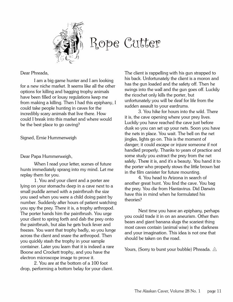
Dear Phreada, The client is rappelling with his gun strapped to his back. Unfortunately the client is a moron and I am a big game hunter and I am looking has the gun loaded and the safety off. Then he for a new niche market. It seems like all the other swings into the wall and the gun goes off. Luckily options for killing and bagging trophy animals the ricochet only kills the porter, but have been filled or lousy regulations keep me unfortunately you will be deaf for life from the from making a killing. Then I had this epiphany, I sudden assault to your eardrums. could take people hunting in caves for the
3. You hike for hours into the wild. There incredibly scary animals that live there. How it is, the cave opening where your prey lives. could I break into this market and where would Luckily you have reached the cave just before be the best place to go caving?dusk so you can set up your nets. Soon you have
the nets in place. You wait. The bell on the net Signed, Ernie Hummerweigh jingles, lights go on. This is the moment of
danger; it could escape or injure someone if not handled properly. Thanks to years of practice and some study you extract the prey from the net Dear Papa Hummerweigh,safely. There it is, and it's a beauty. You hand it to
When I read your letter, scenes of future the porter who properly stows the little brown bat
hunts immediately sprang into my mind. Let me in the film canister for future mounting.
replay them for you.4. You head to Arizona in search of
1. You and your client and a porter are another great hunt. You find the cave. You bag
lying on your stomachs deep in a cave next to a the prey. You die from Hantavirus. Did Darwin
small puddle armed with a paintbrush the size have this in mind when he formulated his
you used when you were a child doing paint by theories?
number. Suddenly after hours of patient watching you spy the prey. There it is, a trophy arthropod.
Next time you have an epiphany, perhaps The porter hands him the paintbrush. You urge
you could trade it in on an aneurism. Other then your client to spring forth and dab the prey onto
bears and giant banana slugs the scariest thing the paintbrush, but alas he gets buck fever and
most caves contain (animal wise) is the darkness freezes. You want that trophy badly, so you lunge
and your imagination. This idea is not one that across the client and snare the arthropod. Then
should be taken on the road.you quickly stash the trophy in your sample container. Later you learn that it is indeed a rare
Yours, (Sorry to burst your bubble) Phreada. Boone and Crockett trophy, and you have the electron microscope image to prove it.
2. You are at the bottom of a 100 foot drop, performing a bottom belay for your client.
Rope Cutter

The Alaskan Caver, Volume 28 No. 1, page 12
additional entrances near the main entrance and obsidian points and may have left the body of the another about 110 feet above the main entrance (which juvenile otter” (p. 15). To date, there is no oral history in corresponds to the upper passage) that collapsed about any of the Alaskan Native communities to support this. six thousand years ago. Heaton (2002a) reported Although no human remains have been found opening that entrance with the help of others. The in El Capitan Cave, Heaton (2002b) identified the entrance was not evident from surveying the slope pelvis, lower jaw, and stone tool of a human that dated outside, so with one caver inside, a voice connection to about 10,300 years old in On Your Knees Cave, was established and it was later dug out. The reason for located north of El Capitan Cave. Forest Service the exhumation was what lay behind the sealed Archaeologist Terry Fifield met with and gained the en trance : a passage adequa te ly named the permission of the Alaskan Native groups (Tlingits and Hibernaculum. Haidas) to excavate and date the remains. This
As reported in Heaton and Grady (2003), in occurred in 1997, a year after the initial find. These are 1992, two years after the initial discovery of the passage the oldest human remains found in Alaska or Canada. and its contents, paleontologists studied the complete Findings in caves are reshaping the human skeleton of a black bear, the remains of a brown bear, migration theory. It was previously thought that humans wolverine, and red fox (as well as the remains of smaller migrated from Asia along an inland, non-glaciated animals such as long-tailed voles). Carlson (1994) states route. Animal remains found in caves indicate that the that the Hibernaculum contained at least four black area must not have been glaciated during the time when bears and three brown bears. The bones range in age the bones were deposited. Coupled with the evidence from 6,400 to 12,300 years old, indicating that the locked in flowstone deposits, experts can retrace glacial passage closed sometime after 6,400 years ago. cycles. The emerging theory is that humans may have
Heaton and Grady (2003) classify different migrated along a non-glaciated coastal route. This portions of El Capitan Cave as either den sites or natural theory is hard-proved: however, most of the evidence is traps. While the Hibernaculum was most likely a den underwater because of relative sea level rise. Therefore, site, providing shelter from the elements and a constant findings in caves are crucial to understanding human temperature, the main entrance of El Capitan Cave is migration to North America. still used by non-humans. People had a hard time Other priceless entities exist inside El Capitan believing me when I told them that river otter used Cave. Aside from being the habitat for two species of bat scent-trails to navigate deep into the cave to den; but the (the Little Brown Bat and the California Bat), river otter hair stuck to the gate (installed to protect bat habitat and continue to use the cave as a den site. Cave-adapted to keep vandals out) was more convincing. species of worms and mites also live in the cave. M a n y
Natural traps are places where animals get of the formations along the tour route have been trapped. These are most likely sinkholes, a karst feature destroyed either by carelessness or vandal ism. that forms when the ceiling of a passage can no longer However, the deeper into the cave one ventures, the support the weight above it, so it collapses. Sinkholes more exquisite the formations become. frequently have vertical (or near vertical) walls that I had the opportunity to go to the Alaska Room, animals cannot climb back out of. Portions of El Capitan a room larger than a football field. The way there is Cave contain natural trap deposits, which is where difficult, either through a tight pinch, or a descent that Heaton and Grady (2003) reportedly found a caribou requires gear, through a passage that intermittently radius, and other bones. The openings of these traps floods, and then inevitably up an ascent that also have closed since the deposition of the bones. requires gear. No signs of vandalism occur past these
In related research, in 1991 Carlson (1994) obstacles. Visitors asked why the formations along the investigated two black obsidian points about 300 feet tour route were so small compared to caves they had from the entrance, as well as flecks of charcoal on the visited elsewhere. The sad truth is that these formations ground from the use of a torch. Test digging in the area were once very spectacular, as they still are in the deeper led Carlson to find a juvenile river otter “sandwiched portions of the cave. between fragmented cedar bark” (p. 15). The otter Guiding tours through El Capitan Cave was not dated to 3,290 B.P., and these cumulative findings led the highlight of my summer. It was learning all about the Carlson to believe that “3,330 or 4,000 years ago the Cave that made my summer outstanding. I arrived with cave was visited by humans who left behind the an appreciation for karst; I left with a passion. El Capitan
A FOCUS ON...EL CAPITAN..., continued from page 5
(continues on page 13)

The Alaskan Caver, Volume 28 No. 1 page 13
CAVING GROUP GETS TOGETHERON PRINCE OF WALES
... EL CAP ADVENTURE, continued from page 8
A FOCUS ON...EL CAPITAN..., continued from page 12
Taira Wilhelm ascends out of Twin Pits after a cold, wet adventure in the Lower Rockwell River passage.
by Johanna Kovarik
Cave is an incredible resource, protecting palentological, Kovarik and McGhee also have plans in the works archaeological, and geological treasures for generations to for a Kid's caving club on the island. Several teachers from come. Sharing a part in peoples' summers many vacationers the Southeast Island School District have voiced their support allowed me to educate them about karst as a resource that for such a group and have volunteered to help with rope must be respected and properly managed. Adul ts training events and caving outings. Members of the new approached me in the grocery store, asking me to explain “adult” caving club have also volunteered to help out. something they had been thinking about since the tour, and I Teaching cave conservation, good caving practices, and knew I instilled in them the importance of karst. I was even ultimately going caving will get kids excited about their told by children, weeks after they took the tour, that they were resource, and will also provide them with the skills and making dioramas of caves. Could anything be more experience to get involved in earth science on a national or honoring? even global scale!
The National Forest Service has cited karst as well as ACKNOWLEDGMENTS “Getting Kids into the Woods” as two of its top priorities in
I would like to sincerely thank, in no particular order, 2008. Along those lines, the Forest Service has agreed to the SCA for sending me to Alaska; Jennifer MacDonald for provide use of helmets, lights and rope to the new caving selecting me, and granting permission to go to the Alaska club. In addition, the Thorne Bay Ranger District has also Room; Jim Baichtal and Terry Fifield for the field trip early on allowed the group to use its facilities for meetings.in the season, and for Kosciusko Island; Don McCully and No regular meeting time has been decided upon as David McNay for being my caving buddies and David of this printing. For more information or to join the group's especially for supplying gear; Emily Bennett for multitudes of email list please contact Johanna Kovarik at 907 828 3224, or priceless photos and for covering for me during my trip to the email at [email protected] Room; and Carlene Allred for helping with some of the specifics of this document. Thank you to all those who taught me this summer, for you have increased my understanding of Southeast Alaska's karst. Thank you for helping to make it all happen. could, and were bathed with spray. By now we were all
chilled and we turned back to head for the surface. Climbing back down the waterfall was another story, for the rushing water soaking me as I tried to find hand and foot holds. We dunked back under the low spot to get back to the dry cave. The return trip upward was a blur as we took turns climbing up the inclines. Kevin and I were the last to go up the last
In December of 2007 community members on ascent, and emerged with Carlene taking photos of us. As we Prince of Wales Island were invited to attend the first official walked out of the cave we noticed that the rushing water had meeting of the Prince of Wales caving club. Flyers were made our suits cleaner than they had been when we went in. distributed across the island, from Whale Pass down to Craig. The late afternoon sun in the trees showed an amazing green, Johanna Kovarik, Glacier Grotto member, organized this first unseen in the cave, and we happily walked down the meeting. “This group presents an opportunity for local mountain, the awe of our journey and excitment for people of all ages to get involved in the world-class caves on tomorrow running loose in our thoughts.their island, and hopefully to raise awareness in Alaska about cave conservation”. Also assisting in the organization of the group was Mary McGhee of Thorne Bay, who works during the summers as the lead cave guide at El Capitan cave.
The group's first meeting attracted ten people, three from Craig, two from Klawock, one from Whale Pass, and four from Thorne Bay. Caving experience in the group ranged from novice to those with prior SRT experience. At the meeting, Glacier Grotto information sheets were passed out to those interested in joining. Information concerning the NSS and other cave conservation groups was also handed out. Copies of the Alaskan Caver and the NSS News were on hand for members to peruse, and a slide show was given with photos of caving in southeast Alaska. Those attending were eager to get underground as soon as possible, and the first caving day was scheduled for January 26th with a trip planned to Wingate Cave and surrounding karst features. Other activities in the near future include SRT training rope
days in the Thorne Bay gym and cave survey classes.

The Alaskan Caver, Volume 28 No. 1 page 14

The Alaskan Caver2525 Fourth Ave.Ketchikan, AK 99901
Address Service Requested