Embed Size (px)
Citation preview
© The Author(s) 2012. This article is published with open access at Springerlink.com csb.scichina.com www.springer.com/scp
*Corresponding author (email: [email protected])
Article
SPECIAL TOPICS:
Geography May 2012 Vol.57 No.14: 16931698
doi: 10.1007/s11434-012-4992-7
The altitude effect of δ18O in precipitation and river water in the Southern Himalayas
WEN Rong1,2, TIAN LiDe1,3*, WENG YongBiao1,2, LIU ZhongFang4 & ZHAO ZhongPing1
1Key Laboratory of Tibetan Environment Changes and Land Surface Processes, Institute of Tibetan Plateau Research, Chinese Academy of Sciences, Beijing 100085, China;
2Graduate University of Chinese Academy of Sciences, Beijing 100049, China; 3State Key Laboratory of Cryosphere Sciences, Cold and Arid Regions Environmental and Engineering Research Institute, Chinese Academy of
Sciences, Lanzhou 730000, China; 4 Tianjin Key Laboratory of Water Environment and Water Resource, Tianjin Normal University, Tianjin 300387, China
Received October 18, 2011; accepted December 14, 2011; published online March 8, 2012
The lapse rate of water isotopes is used in the study of the hydrologic cycle as well as in the estimation of uplift of the Tibetan Plateau. The greater elevation contrast in the Southern Himalayas allows for a detailed discussion about this lapse rate. We ana-lyze variations of δ18O in precipitation and river water between 1320 m and 6700 m elevations in the Southern Himalayas, and calculate the specific lapse rate of water δ18O. The results show that the multi-year average lapse rate in precipitation over this region is 0.15‰/100 m. The one-year average lapse rate is 0.17‰/100 m from three sites along the Southern Himalayas. The two results agree, but are much lower than the global average of 0.28‰/100 m. This work also shows that there is a difference in pre-cipitation δ18O lapse rate between the monsoon and non-monsoon seasons. The calculated precipitation lapse rate is much lower than that in surface water.
δ18O, precipitation, river water, isotopic lapse rate, southern Himalayas
Citation: Wen R, Tian L D, Weng Y B, et al. The altitude effect of δ18O in precipitation and river water in the Southern Himalayas. Chin Sci Bull, 2012, 57: 16931698, doi: 10.1007/s11434-012-4992-7
Understanding water stable isotopes in the Tibetan Plateau region is a prerequisite of paleoclimate and paleoenviron-mental work. They have a variety of applications, such as paleothermometry in ice core studies [1–6] and as environ-mental tracers in the regional hydrologic cycle [7–10]. In recent years, the oxygen isotope has been used as an altim-eter for plateau uplift. This is related to the “altitude effect”, in which the precipitation isotope decreases with altitude. Thus, it is likely that isotope signals from the paleo-sedi- ment record may preserve information about plateau uplift. Oxygen isotope signals from paleosoil have been used to reconstruct the uplift history of the plateau [11–20]. The stable isotope lapse rate is also used to calculate the contri-bution of tributaries from different elevations [21].
A crucial issue is calculating the precise isotopic lapse
rate [15]. This can be achieved by a few approaches, such as isotopes in precipitation, river water, snow and ice, as well as modeling based on Rayleigh fractionation [21–29]. Yao et al. [22] studied the impact of the Indian monsoon on δ18O lapse rate in different waters. However, there is still an open question, which is related to the following. Water isotopes are influenced by global and regional hydrologic cycles. This is especially true for the Tibetan Plateau, where large- scale atmospheric circulation interactions cause large spatial and temporal changes of precipitation isotopes [8,11,30]. Prior investigations were mainly restricted to regions below 5000 m altitude. The application of these findings for eval-uating plateau uplift at higher elevations has been ques-tioned [28]. The easiest and most feasible method is to use the river water isotope to evaluate isotopic lapse rate [13, 22,29,31–35]. However, there is also uncertainty in this isotope that can affect lapse rate calculation. The isotope is
1694 Wen R, et al. Chin Sci Bull May (2012) Vol.57 No.14
an average of the water isotope from the entire basin above the river water-sampling site. The river water isotope changes seasonally. Earlier work on the Southern Tibetan Plateau shows that there is a greater shift in the precipitation δ18O in winter than in summer [7,8]. The river water isotope is a result of isotope fractionation in land surface evapora-tion. However, this effect is difficult to evaluate quantita-tively for different catchments. Considering the above un-certainties, the most feasible method is to estimate a rela-tively constant isotopic lapse rate using the long-term con-tinuous precipitation δ18O.
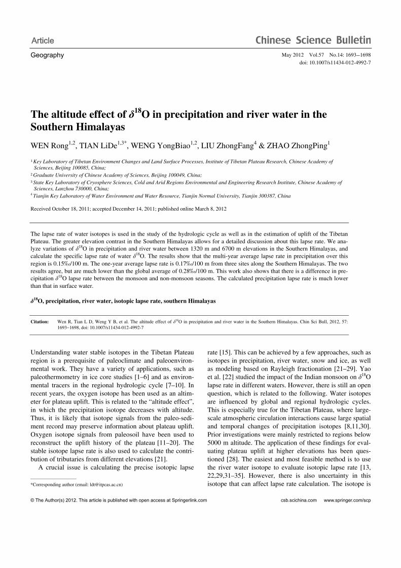
The Southern Himalayas region is ideal for calculating the precipitation isotopic lapse rate, because it has a large altitude contrast over a short distance. This may effectively reduce the spatial effect of the precipitation isotope on lapse rate calculation. Although there is a Global Network of Iso-topes in Precipitation (GNIP), it has few stations on the Ti-betan Plateau. We also maintain a regional network of iso-topes in precipitation in the plateau area. Unfortunately, most of these stations are on the part of the plateau inland of the Himalayan range, and their isotopic data are not usable for lapse rate calculation. Instead, we use isotope data, including precipitation and ice core, from three stations in the Southern Himalayas to obtain reliable precipitation isotopic lapse rates. We also compare those with river water lapse rates.
1 Study area
The study region is in the middle of Southern Himalayas, shown in Figure 1. The three sampling sites, from higher to lower elevation, are Dasuopu glacier (Xixibangma), Nyalam and Kathmandu. The Dasuopu ice core-drilling site (28.38°N, 85.73°E) is in a large flat area at 6700 m, on the upper Dasuopu Glacier. A Dasuopu ice core drilled in 1997 reveals climate change over the last 2000 years [2,36,37]. Nyalam (28.18°N, 85.97°E) is in the middle of the Southern slope of the Himalayas, at an altitude of 3811 m. The third station is Kathmandu (27.69°N, 85.36°E), capital of Nepal, at an altitude of 1320 m. River water was sampled from the Boqu River. This river is recharged by glacier meltwater and precipitation, and flows from the Himalayan summits to Nepal, and ultimately to the Indian Ocean.
2 Water sampling and measurement
We use continuous precipitation isotope data from Kath-
mandu and Nyalam, where there is continuous in situ ob-servation. Precipitation was sampled over the entire year of 1998 in Kathmandu, attaining 116 samples. At Nyalam, sampling was from 1996–2010, obtaining 1281 samples. For the higher site, we use the shallow ice core isotope from Dasuopu Glacier instead of precipitation data. It has been demonstrated that the impact of post-deposition processes on the isotopic signal can be ignored [38]. On 19 August 2006, a shallow ice core of 16.8 m depth was drilled in the glacier. This ice core was dated to 1991, based on the sea-sonal change of δ18O [39]. On August 20, 2010, a snow pit of 2 m depth was sampled at 0.1 m intervals. This snow pit spanned a 2-year snow accumulation. There were 210 sam-ples from the glacier. Table 1 details the water sampling, including location, duration and total number of samples.
For comparison, river water samples were collected from the main stream of Boqu River. There were 39 river sam-ples collected from September 26–27, 2011, over an altitude range of 1845–5057 m. Sampling altitude was measured by a portable GPS.
Figure 1 Research area and sampling sites.
Table 1 Precipitation sampling at three sampling sites in Southern Himalayas
Station Latitude (N) Longitude (E) Altitude (m) Sampling period Number of samples
Kathmandu 27.69° 85.36° 1320 1998-04–1999-02 116
Nyalam 28.18° 85.97° 3811 1997–2010 1281
Dasuopu Glacier 28.38° 85.73° 6700 1997–2010 210
Wen R, et al. Chin Sci Bull May (2012) Vol.57 No.14 1695
Most water samples were measured with a Finnigan MAT 253 mass spectrometer at the Key Laboratory of Tibetan Plateau Environment Changes and Land Surface Processes (TEL), within the Institute of Tibetan Plateau Research of the Chinese Academy of Sciences (CAS) in Beijing. The measurements have an analytical precision of ±0.1‰ for δ18O. Precipitation samples before 2004 were measured with a Finnigan MAT 252 at the State Key La-boratory of Cryosphere Sciences within the Cold and Arid Regions Environmental and Engineering Research Institute of CAS in Lanzhou. Measurement precision was ±0.2‰ for δ18O. Samples in 2010 were analyzed with a Picarro Liquid Water Analyzer at TEL, with precision ±0.15‰ for δ18O. The value of isotopic ratio is expressed per mil relative to Vienna Standard Mean Ocean Water (VSMOW).
The average δ18O of precipitation here is the weighted mean of precipitation amount. δ18O in the shallow ice core and firn pit is the weighted mean with firn density. All data are normally distributed, with a 0.05 significance level.
3 Results and discussion
3.1 δ18O lapse rate from precipitation in Southern Himalayas
We examine the precipitation δ18O lapse rate in the South-ern Himalayas. The annual δ18O lapse rate is estimated from precipitation and snow data, from the three sites at different elevations. Seasonal changes are also discussed. The multi- year average δ18O lapse rate is calculated with precipitation δ18O from two sites.
For the annual lapse rate, we used 116 precipitation sam-ples at Kathmandu from the period April 1998 through Feb-ruary 1999. There were 129 precipitation samples at Nyalam during the period March 1998 through February 1999. δ18O at Dasuopu Glacier is from the same period but taken from the 2006 shallow ice core, which included 16 firn samples.
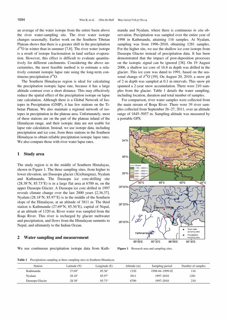
Based on the annual δ18O at the three sites, Figure 2 gives the variation of precipitation δ18O with altitude during 1998. This δ18O decrease varied from −8.7‰ at Kathmandu to −11.3‰ at Nyalam, and −17.7‰ in Dasuopu, in order of increasing altitude. The error bars in Figure 2 represent the standard deviations of the entire δ18O dataset at each site. The linear correlation between δ18O and elevation is δ18O = −0.0017h – 5.74 (r2 = 0.95), where h is elevation in m. The slope of the regression equation shows a precipitation δ18O lapse rate of about 0.17‰/100 m. This calculated lapse rate is much lower than the global average of 0.28‰/100 m [23].
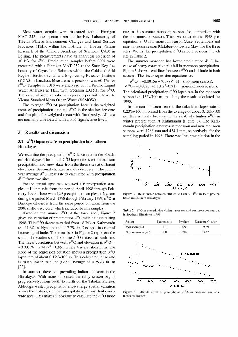
In summer, there is a prevailing Indian monsoon in the Himalayas. With monsoon onset, the rainy season begins progressively, from south to north on the Tibetan Plateau. Although winter precipitation shows large spatial variation across the plateau, summer precipitation is consistent over a wide area. This makes it possible to calculate the δ18O lapse
rate in the summer monsoon season, for comparison with the non-monsoon season. Thus, we separate the 1998 pre-cipitation δ18O into monsoon season (June–September) and non-monsoon season (October–following May) for the three sites. We list the precipitation δ18O in both seasons at each site in Table 2.
The summer monsoon has lower precipitation δ18O, be-cause of heavy convective rainfall in monsoon precipitation. Figure 3 shows trend lines between δ18O and altitude in both seasons. The linear regression equations are
δ18O = −0.0015h − 9.17 (r2=1) (monsoon season), δ18O = −0.0023h+1.10 (r2=0.91) (non-monsoon season).
The calculated precipitation δ18O lapse rate in the monsoon season is 0.15‰/100 m, matching the result calculated for 1998.
In the non-monsoon season, the calculated lapse rate is 0.23‰/100 m, biased from the average of about 0.15‰/100 m. This is likely because of the relatively higher δ18O in winter precipitation at Kathmandu (Figure 3). The Kath-mandu precipitation amounts in monsoon and non-monsoon seasons were 1286 mm and 424.1 mm, respectively, for the sampling period in 1998. There was less precipitation in the
Figure 2 Relationship between altitude and annual δ18O in 1998 precipi-tation in Southern Himalayas.
Table 2 δ18O in precipitation during monsoon and non-monsoon seasons in Southern Himalayas, 1998
Station Kathmandu Nyalam Dasuopu Glacier
Monsoon (‰) −11.17 −14.93 −19.29
Non-monsoon (‰) −1.07 −9.04 −13.37
Figure 3 Altitude effect of precipitation δ18O, in monsoon and non- monsoon seasons.
1696 Wen R, et al. Chin Sci Bull May (2012) Vol.57 No.14
non-monsoon season, and most of it occurred in a few events; this weakens the representativeness of the isotope data.
The seasonal and annual changes, as well as spatial vari-ations in precipitation δ18O, can increase uncertainty in the calculated isotopic lapse rate. The multi-year average can effectively smooth this uncertainty [28]. Here, we use long- term observation of precipitation δ18O to evaluate a more stable δ18O lapse rate in the Southern Himalayas. Because long-term isotope observations are very sparse, we use the precipitation δ18O at only two sites, Nyalam and Dasuopu Glacier.
At Nyalam, precipitation δ18O data are from 1997 to 2010. There were interruptions in precipitation sampling during 2001, 2002 and 2004, so we use average precipitation δ18O data from the remaining 11 years. For Dasuopu, we use av-erage δ18O data from the period 1997−2006, preserved in the 2006 ice core, and 2-year data from the 2010 firn pit.
The weighted mean of multi-year precipitation δ18O is −17.1‰, calculated from the Dasuopu ice core at 6700 m. The weighted mean of multi-year precipitation δ18O is −12.7‰ at Nyalam, 3811 m (Table 3). This yields a precip-itation δ18O lapse rate of 0.15‰/100 m. This lapse rate from multi-year average precipitation isotope data is close to the annual value of 0.17‰/100 m, calculated from precipitation isotope data at the three sites in 1998. These results also match the result from the monsoon season. This consistency confirms that reliable δ18O lapse rates can be estimated from long-term observation of precipitation isotopes. The work also shows that the lapse rate is much lower in the Southern Himalayas than the global average (0.28‰/100 m).
The smaller δ18O lapse rate is consistent with Hou et al. [28]. This substantiates the unique δ18O lapse rate in the Southern Himalayas, which is affected by summer Indian monsoon precipitation. It is believed that the lower lapse rate is related to heavy convective precipitation [28], which the classical Rayleigh fractionation model cannot capture. The stratification of δ18O lapse rate into monsoon and non-monsoon seasons shows that the monsoon-season lapse rate is close to the multi-year average. Limited data from non-monsoon precipitation produce a higher lapse rate. The seasonal lapse rate difference confirms that monsoon pre-cipitation is involved in the reduced lapse rate in the South-ern Himalayas.
Another possible factor is the altitude of cloud bottom. This altitude changes abruptly over a short distance along the Southern Himalayas, but may not change as much as the topography. The precipitation δ18O is affected by the alti-tude of moisture condensation in cloud, not by terrain alti-tude. As shown above, the results calculated from terrain
elevation yield a lower δ18O lapse rate. Nevertheless, this relationship needs further work.
According to the Rayleigh isotopic fractionation model [15], the relationship between precipitation δ18O and altitude is not linear, especially at extremely high elevation. At high elevation, the δ18O lapse rate decreases. Our result, derived from precipitation δ18O over an altitude span 1320−6700 m, is 0.15‰/100 m. Kang et al. [27] obtained a lapse rate of 0.1‰/100 m from δ18O variation in new snow between 5800 m and 7000 m. Both these results from the Himalayas are relatively low.
We attempt to obtain a constant isotopic lapse rate from precipitation in the Southern Himalayas. The number of observation stations and duration of observation are lacking. Further, the annual variation of precipitation isotopes is large, and is difficult to evaluate. There is still a great need for long-term, continuous observation at more stations in the region, toward an improved understanding of the precip-itation isotopic lapse rate.
3.2 δ18O lapse rate from river water in the Southern Himalayas and comparison with precipitation result
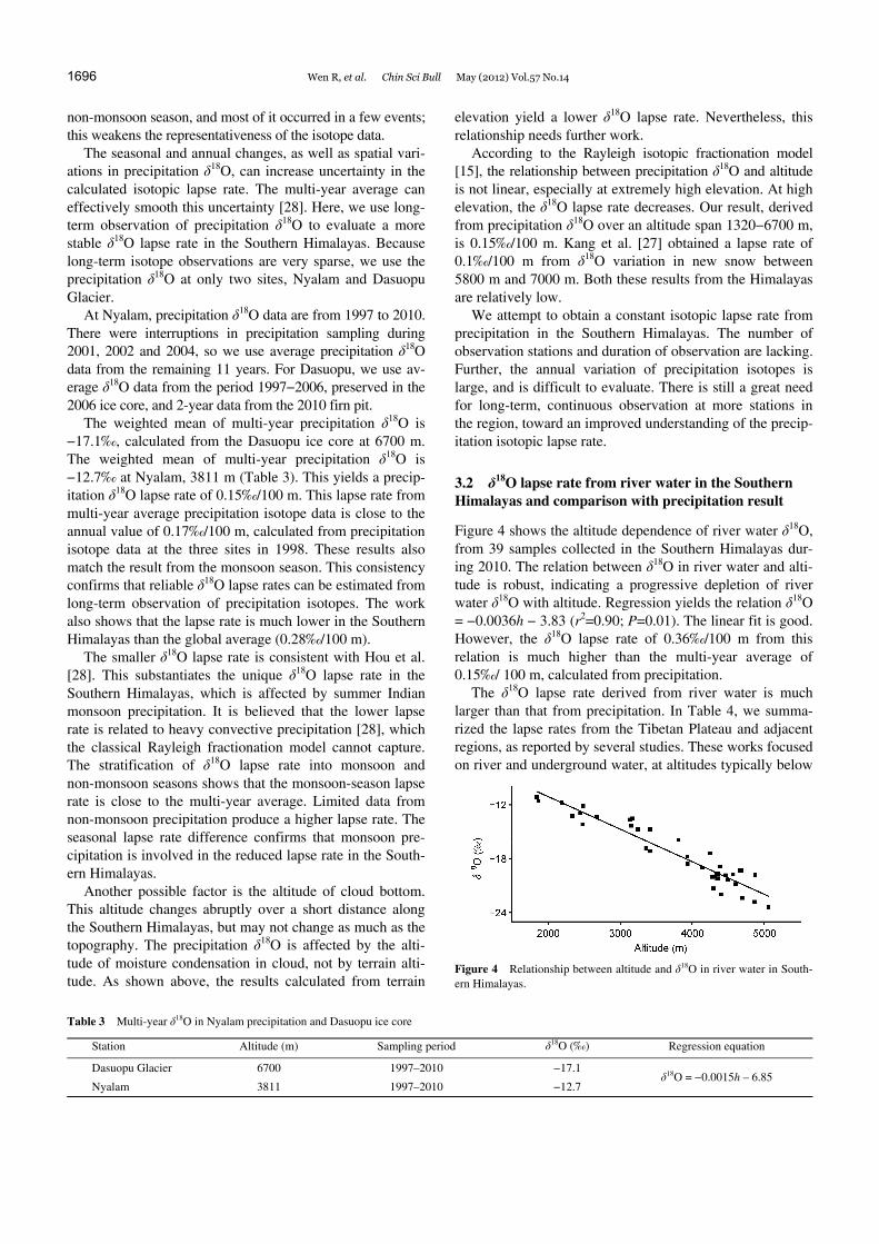
Figure 4 shows the altitude dependence of river water δ18O, from 39 samples collected in the Southern Himalayas dur-ing 2010. The relation between δ18O in river water and alti-tude is robust, indicating a progressive depletion of river water δ18O with altitude. Regression yields the relation δ18O = −0.0036h − 3.83 (r2=0.90; P=0.01). The linear fit is good. However, the δ18O lapse rate of 0.36‰/100 m from this relation is much higher than the multi-year average of 0.15‰/ 100 m, calculated from precipitation.
The δ18O lapse rate derived from river water is much larger than that from precipitation. In Table 4, we summa- rized the lapse rates from the Tibetan Plateau and adjacent regions, as reported by several studies. These works focused on river and underground water, at altitudes typically below
Figure 4 Relationship between altitude and δ18O in river water in South-ern Himalayas.
Table 3 Multi-year δ18O in Nyalam precipitation and Dasuopu ice core
Station Altitude (m) Sampling period δ18O (‰) Regression equation
Dasuopu Glacier 6700 1997–2010 −17.1 δ18O = −0.0015h – 6.85
Nyalam 3811 1997–2010 −12.7
Wen R, et al. Chin Sci Bull May (2012) Vol.57 No.14 1697
Table 4 δ18O lapse rate in water in the Himalaya-Tibetan Plateau region
Regional of interest Type of water Altitude range (m) Lapse rate (‰/100 m) Reference
Global precipitation, snow, ice 0.28 [25]
The northern slope of the Himalayas new snow 5800–7000 0.1 [27]
The southern slope of the Himalayas precipitation 3811–6700 0.15–0.17 this paper
Tibetan Plateau precipitation <5000 0.33 [22]
The southern slope of the Himalayas river 1845–5057 0.36 this paper
Tibetan Plateau river <5000 0.31 [22]
The northeast of Tibetan Plateau Brahmaputra <5000 0.14 [29]
Northeastern Tibetan Plateau, Qilian Mountain Heihe River <5000 0.18 [21]
The front of the Himalayas, the east edge of the Tibetan Plateau groundwater, stream <4000 0.29 [30,31]
Riverhead of Ganges river 300–3000 0.19 [32]
Southwest of the Himalayas river 400–2400 0.11 [33]
Northern and southern Tibetan Plateau river 900–5500 0.24 [13]
Kumaun Himalayas river, spring 915–2150 0.14–0.15 [34]
India geothermal springs 0.2–0.3 [35]
5000 m. Compared with precipitation, the calculated δ18O lapse rate shows a large range, from 0.1 to 0.36‰/100 m. Also, lapse rates in river water are usually higher, with an average around 0.23‰/100 m, compared with the average 0.15‰/100 m from precipitation.
There are several reasons for the difference in isotopic lapse rate between precipitation and river water. The river water isotope value is actually an average of water in the entire basin above the sampling site. The altitude of the sampling site is not equal to the average basin altitude. The basin area, river discharge processes, types of water origin in the basin (precipitation, glacier melt water, underground water, and others), and seasonality of precipitation can all modify the river water isotopic component, and thus the calculated isotopic lapse rate. But quantitative evaluation of these factors is lacking.
Land surface evaporation is another possible reason. With lower altitude, and therefore higher temperature, heavy iso-tope enhancement in residual water is more significant. This process increases the calculated isotopic lapse rate from river water, making it higher than that of precipitation. Further, there are undetermined parameters affecting this process.
4 Conclusion
Based on δ18O variations in precipitation and ice along a section from 1320 m to 6700 m elevation in the Southern Himalayas, we calculated the δ18O lapse rate on both annual and multi-year scales. Results show that the δ18O lapse rate is 0.15‰/100 m on the multi-year scale, and 0.17‰/100 m on the annual scale from three sites. These results are very close, but are much lower than the global average of 0.28‰/ 100 m. Limited data also reveal that the isotopic lapse rate is smaller in the monsoon season, and higher in the non- monsoon season. This implies a role for monsoon precipita-tion in the reduced δ18O lapse rate found in the Southern Himalayas. We also found that the isotopic lapse rate is
generally higher in river water than in precipitation, and also has a large fluctuation.
We are indebted to two anonymous reviewers for their valuable comments and suggestions. This work was supported by the National Basic Research Program of China (2010CB951702), the National Natural Science Founda-tion of China (41025002), and the Knowledge Innovation Program of the Chinese Academy of Sciences (KZCX2-YW-Q09-03 and KZCX2-YW-GJ05).
1 Yao T D. Ice core study of the Tibetan Plateau (in Chinese). J Glaciol Geocryol, 1998, 20: 233–237
2 Yao T D, Duan K Q, Tian L D, et al. Dasuopu ice core accumulation records and the change of Indian monsoon precipitation for past 400 a (in Chinese). Sci China Ser D-Earth Sci, 2000, 30: 619–627
3 Johnsen S J, Dahl Jensen D, Gundestrup N, et al. Oxygen isotope and palaeotemperature records from six Greenland ice core stations: Camp Century, Dye 3, GRIP, GISP2, Renland and North GRIP. J Quat Sci, 2001, 16: 299–307
4 Jouzel J, Alley R B, Cuffey K, et al. Validity of the temperature re-construction from water isotopes in ice cores. J Geophys Res, 1997, 102: 26471–26487
5 Johnsen S J, Clausen H B, Dansgaard W, et al. The δ18O record along the Greenland Ice Core Project deep ice core and the problem of pos-sible Eemian climatic instability. J Geophys Res, 1997, 102: 26397– 26410
6 Johnson K R, Ingram B L. Spatial and temporal variability in the sta-ble isotope systematics of modern precipitation in China: Implica-tions for paleoclimate reconstructions. Earth Planet Sci Lett, 2004, 220: 365–377
7 Tian L, Yao T, Numaguti A, et al. Relation between stable isotope in monsoon precipitation in southern Tibetan Plateau and moisture transport history. Sci China Ser D-Earth Sci, 2001, 44(Suppl): 267–274
8 Tian L, Yao T, Macclune K, et al. Stable isotopic variations in west China: A consideration of moisture sources. J Geophys Res-Atmos, 2007, 112: D10112
9 Kang S, Qin D, Ren J, et al. Relationships between an ice core rec-ords from southern Tibetan Plateau and atmospheric circulation over Asia (in Chinese). Quat Sci, 2006, 26: 153–164
10 Harris N. The elevation history of the Tibetan Plateau and its implica-tions for the Asian monsoon. Palaeogeogr Palaeoclimatol Palaeoecol, 2006, 241: 4–15
11 Hren M T, Bookhagen B, Blisniuk P M, et al. δ18O and δD of streamwaters across the Himalaya and Tibetan Plateau: Implications for moisture sources and paleoelevation reconstructions. Earth Planet Sci Lett, 2009, 288: 20–32
12 Putkonen J K. Continuous snow and rain data at 500 to 4400 m altitude
1698 Wen R, et al. Chin Sci Bull May (2012) Vol.57 No.14
near Annapurna, Nepal, 1999-2001. Arct Antarct Alp Res, 2004, 36: 244–248
13 Ding L, Xu Q, Zhang L Y, et al. Regional variation of river water oxygen isotope and empirical elevation prediction models in Tibetan Plateau (in Chinese). Quat Sci, 2009, 29: 1–12
14 Xu Q, Ding L, Zhang L Y, et al. Stable isotopes of modern herbivore tooth enamel in the Tibetan Plateau: Implications for paleoelevation reconstructions. Chin Sci Bull, 2009, 54: 2160–2168
15 Rowley D B, Currie B S. Palaeo-altimetry of the late Eocene to Mio-cene Lunpola basin, central Tibet. Nature, 2006, 439: 677–681
16 Lehnert O, Fryda J, Buggisch W, et al. δ13C records across the late Silurian Lau event: New data from middle palaeo-latitudes of north-ern peri-Gondwana (Prague Basin, Czech Republic). Palaeogeogr Palaeoclimatol Palaeoecol, 2007, 245: 227–244
17 Chen Z L, Wang X F, Feng X H, et al. Application of stable isotope in reconstructing the uplift history of mountains (in Chinese). Bull Mineral Petrol Geochem, 2001, 20: 211–213
18 Guo Z T, Wu H B, Wei J J, et al. Tentative estimate of the southeast margin uplift of Qinhai-Xizang Plateau using organic carbon isotope composition of paleosols (in Chinese). Quat Sci, 2001, 21: 392–398
19 Wu Z H, Zhao X, Ye B S, et al. Paleo-elevation of the Tibetan Plat-eau inferred from carbon and oxygen isotopes of lacustrine deposits (in Chinese). Acta Geol Sin, 2007, 81: 1277–1288
20 Holdsworth G, Fogarasi S, Krouse H R. Variation of the stable iso-topes of water with altitude In the Saint Elias Mountains of Canada. J Geophys Res-Atmos, 1991, 96: 7483–7494
21 Wang N L, Zhang S B, He J Q, et al. Tracing the major source area of the mountainous runoff generation of the Heihe River in northwest Chi-na using stable isotope technique. Chin Sci Bull, 2009, 54: 2751–2757
22 Yao T D, Zhou H, Yang X X. Indian monsoon influences altitude ef-fect of δ18O in precipitation/river water on the Tibetan Plateau. Chin Sci Bull, 2009, 54: 2724–2731
23 Rowley D B, Pierrehumbert R T, Currie B S. A new approach to sta-ble isotope-based paleoaltimetry: Implications for paleoaltimetry and paleohypsometry of the High Himalaya since the Late Miocene. Earth Planet Sci Lett, 2001, 188: 253–268
24 Rowley D B, Garzione C N. Stable isotope-based paleoaltimetry. Annu Rev Earth Planet Sci, 2007, 35: 463–508
25 Poage M A, Chamberlain C P. Empirical relationships between ele-vation and the stable isotope composition of precipitation and surface waters: Considerations for studies of paleoelevation change. Am J Sci, 2001, 301: 1–15
26 Quade J, Garzione C, Eiler J. Paleoelevation reconstruction using pedogenic carbonates. Palaeogeogr Palaeoclimatol Palaeoecol, 2007,
66: 53–87 27 Kang S C, Karl J K, Mayewski P, et al. Stable isotopic composition
of precipitation over the northern slope of the central Himalaya. J Glaciol, 2002, 163: 519–526
28 Hou S, Valérie M-D, Qin D, et al. Modern precipitation stable iso-tope vs. elevation gradients in the High Himalaya. Comment on A new approach to stable isotope-based paleoaltimetry: Implications for paleoaltimetry and paleohypsometry of the High Himalaya since the Late Miocene by David B. Rowley et al. [Earth Planet Sci Lett 188 (2001) 253–268]. Earth Planet Sci Lett, 2003, 209: 395–399
29 Yang X X, Xu B Q, Yang W, et al. Study of altitudinal lapse rates of δ18O in precipitation/river water with seasons on the southeast Tibet-an Plateau. Chin Sci Bull, 2009, 54: 2742–2750
30 Zhang X P, Liu J M, Tian L D, et al. Variations of δ18O in precipita-tion along vapor transport Paths over Asia (in Chinese). Acta Geogr Sin, 2004, 59: 699–708
31 Garzione C N, Quade J, DeCelles P G, et al. Predicting paleoeleva-tion of Tibet and the Himalaya from δ18O vs. altitude gradients in meteoric water across the Nepal Himalaya. Earth Planet Sci Lett, 2000, 183: 215–229
32 Garzione C N, Dettman D L, Quade J, et al. High times on the Tibet-an Plateau: Paleoelevation of the Thakkhola graben, Nepal. Geology, 2000, 28: 339–342
33 Ramesh R, Sarin M M. Stable isotope study of the Ganga (Ganges) River system. J Hydrol, 1992, 139: 49–62
34 Dalai T K, Bhattacharya S K, Krishnaswami S. Stable isotopes in the source waters of the Yamuna and its tributaries: Seasonal and altitu-dinal variations and relation to major cations. Hydrol Process, 2002, 16: 3345–3364
35 Bartarya S K, Bhattacharya S K, Ramesh R, et al. δ18O and δD sys-tematics in the surficial waters of the Gaula river catchment area, Kumaun Himalaya, Indian. J Hydrol, 1995, 167: 369–379
36 Yao T D, Thompson L G, Duan K Q, et al. Temperature and methane records over the last 2 ka in Dasuopu ice core. Sci China Ser D-Earth Sci, 2002, 45: 1068–1074
37 Thompson L G, Yao T, Mosley-Thompson E, et al. A high-resolution millennial record of the South Asian Monsoon from Himalayan ice cores. Science, 2000, 289: 1916–1919
38 Grootes P M, Stuiver M, Thompson L G, et al. Oxygen isotope changes in tropical ice, Quelccaya, Peru. J Geophys Res, 1989, 94: 1187– 1194
39 Wang P L, Yao T D, Tian L D, et al. Recent high-resolution glacio-chemical record from a Dasuopu firn core of middle Himalaya. Chin Sci Bull, 2008, 53: 418–425
Open Access This article is distributed under the terms of the Creative Commons Attribution License which permits any use, distribution, and reproduction
in any medium, provided the original author(s) and source are credited.