Embed Size (px)
Citation preview
The Bisbee Group of the Tombstone Hills, Southeastern Arizona Stratigraphy, Structure, Metamorphism, and Mineralization
U.S. GEOLOGICAL SURVEY BULLETIN 2042-B
AVAILABILITY OF BOOKS AND MAPS OF THE U.S. GEOLOGICAL SURVEY
Instructions on ordering publications of the U.S. Geological Survey, along with prices of the last offerings, are given in the current- year issues of the monthly catalog "New Publications of the U.S. Geological Survey." Prices of available U.S. Geological Survey publications released prior to the current year are listed in the most recent annual "Price and Availability List." Publications that are listed in various U.S. Geological Survey catalogs (see back inside cover) but not listed in the most recent annual "Price and Availability List" are no longer available.
Reports released through the NTIS may be obtained by writing to the National Technical Information Service, U.S. Department of Commerce, Springfield, VA 22161; please include NTIS report number with inquiry.
Order U.S. Geological Survey publications by mail or over the counter from the offices given below.
BY MAIL OVER THE COUNTER
Books
Professional Papers, Bulletins, Water-Supply Papers, Tech niques of Water-Resources Investigations, Circulars, publications of general interest (such as leaflets, pamphlets, booklets), single copies of Earthquakes & Volcanoes, Preliminary Determination of Epicenters, and some miscellaneous reports, including some of the foregoing series that have gone out of print at the Superin tendent of Documents, are obtainable by mail from
U.S. Geological Survey, Information ServicesBox 25286, Federal Center
Denver, CO 80225
Subscriptions to periodicals (Earthquakes & Volcanoes and Preliminary Determination of Epicenters) can be obtained ONLY from the
Superintendent of DocumentsGovernment Printing Office
Washington, DC 20402
(Check or money order must be payable to Superintendent of Documents.)
Maps
For maps, address mail orders to
U.S. Geological Survey, Map DistributionBox 25286, Bldg. 810, Federal Center
Denver, CO 80225
Residents of Alaska may order maps from
U.S. Geological Survey, Earth Science Information Center101 Twelfth Ave., Box 12
Fairbanks, AK 99701
Books and Maps
Books and maps of the U.S. Geological Survey are available over the counter at the following U.S. Geological Survey offices, all of which are authorized agents of the Superintendent of Docu ments.
ANCHORAGE, Alaska 4230 University Dr., Rm. 101
LAKEWOOD, Colorado Federal Center, Bldg. 810
MENLO PARK, California Bldg. 3, Rm. 3128, 345 Mid- dlefield Rd.
RESTON, Virginia National Center, Rm. 1C402, 12201 Sunrise Valley Dr.
SALT LAKE CITY, Utah Federal Bldg., Rm. 8105, 125 South State St.
SPOKANE, Washington U.S. Post Office Bldg., Rm. 135, W 904 Riverside Ave.
WASHINGTON, D.C. Main Interior Bldg., Rm. 2650, 18th and C Sts., NW.
Maps Only
Maps may be purchased over the counter at the U.S. Geologi cal Survey offices:
FAIRBANKS, Alaska New Federal Building, 101 Twelfth Ave.
ROLLA, Missouri 1400 Independence Rd.
STENNIS SPACE CENTER, Mississippi Bldg. 3101
Chapter B
The Bisbee Group of the Tombstone Hills, Southeastern Arizona Stratigraphy, Structure, Metamorphism, and Mineralization
By Eric R. Force
Unraveling the complex geology of major host rocks makes possible a better understanding of ore deposits in the Tombstone Basin area
U.S. GEOLOGICAL SURVEY BULLETIN 2042-B
MINERAL RESOURCE STUDIES ALONG THE SIERRITA-MOGOLLON TRANSECT, ARIZONA-NEW MEXICO
U.S. DEPARTMENT OF THE INTERIOR BRUCE BABBITT, Secretary
U.S. GEOLOGICAL SURVEY Gordon P. Eaton, Director
Any use of trade, product, or firm namesin this publication is for descriptive purposes onlyand does not imply endorsement by the U.S. Government
Text edit and layout by Mary Lou Callas Illustrations edit by Julia Thomas Graphics by Nancy L. Hoskin
UNITED STATES GOVERNMENT PRINTING OFFICE, WASHINGTON: 1996
For sale byU.S. Geological Survey, Information ServicesBox 25286, Federal Center,Denver, CO 80225
Library of Congress Cataloging in Publication Data
Force, Eric R.The Bisbee Group of the Tombstone Hills, southeastern Arizona :
stratigraphy, structure, metamorphism, and mineralization / by Eric R. Force.
p. cm. {U.S. Geological Survey bulletin : 2042) (Mineral resource studies along the Sierrita-Mogollon Transect, Arizona-New Mexico ; ch. B)
Includes bibliographical references.Supt. of Docs, no.: I 19.3:2042-61. Geology Arizona Tombstone Hills Region. 2. Mines and mineral
resources Arizona Tombstone Hills Region. 3. Bisbee Group (Ariz. and N.M.) I. Title. II Series. III. Series: Mineral resource studies along the Sierrita-Mogollon Transect, Arizona-New Mexico : ch. B. QE75.B9 no. 2042-B [QE86.T62] 557.3 s dc20[557.91'5] 94-48905
CIP
CONTENTS
Abstract Bl Introduction Bl
Nature and distribution of the Bisbee Group B2Previous work B3This study B4Acknowledgments B5
Western area B5Stratigraphy of the Bisbee Group B5
Lower unit of the Bisbee Group B5 Upper unit of the Bisbee Group B6
Relations with igneous rocks B6Schieffelin Granodiorite (Late Cretaceous) B6 Uncle Sam Porphyry (Late Cretaceous) B7 Porphyry dikes B7
Metamorphism B8Structure B8
Folds B8Northeast-striking faults B8 Ajax Hill Fault B8 Prompter Fault B9
Mineralization B9 Tombstone Basin BIO
Stratigraphy of the Bisbee Group BIO Basal unconformity BIO Lower unit of the Bisbee Group BIO Upper unit of the Bisbee Group Bll Stratigraphic-lithologic summary B12
Structure B12Basin-and-range faults B12 Tranquility and related faults B12 Northeast-striking fractures (fissures) B15 Faults intruded by dikes B15 Dome-and-basin folds B15 Decollements B16 Rolls and related faults B16
Relations with igneous rocks B17 Schieffelin Granodiorite B17 Porphyry dikes B17 Olivine basalt dike B18
Metamorphism B18Mineralization B19
Favorable horizons B19 Favorable structural conduits B19 Favorable structural entrapment sites B20
Comparison of areas B20 References cited B21
Contents III
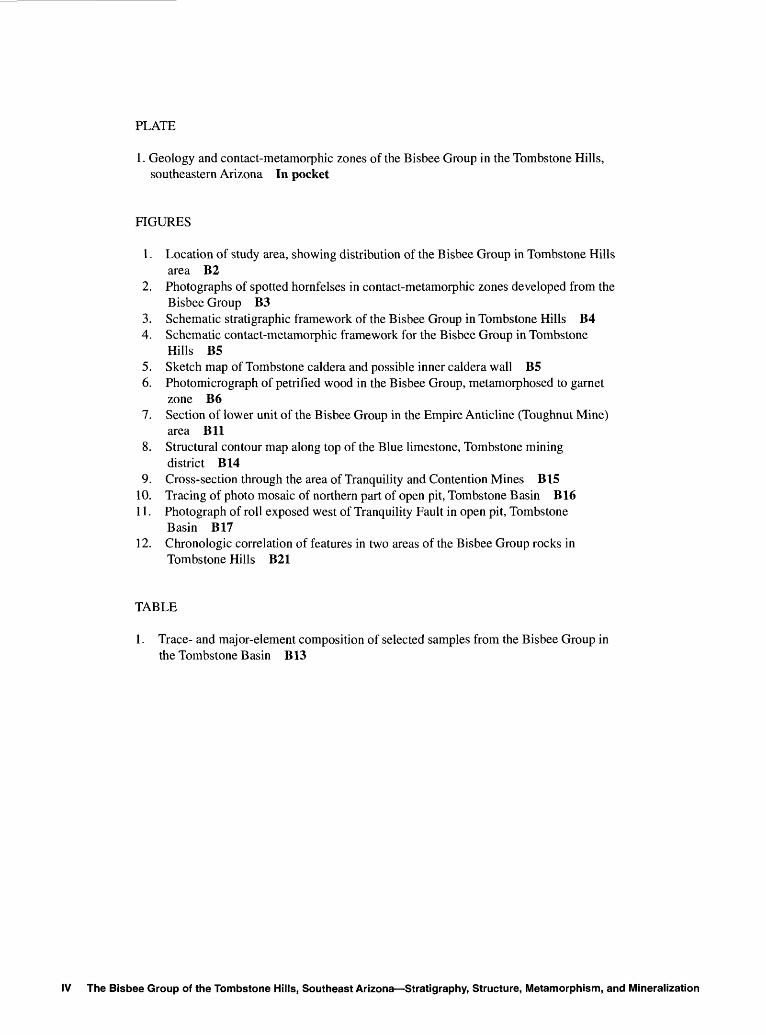
PLATE
1. Geology and contact-metamorphic zones of the Bisbee Group in the Tombstone Hills, southeastern Arizona In pocket
FIGURES
1. Location of study area, showing distribution of the Bisbee Group in Tombstone Hills area B2
2. Photographs of spotted hornfelses in contact-metamorphic zones developed from the Bisbee Group B3
3. Schematic strati graphic framework of the Bisbee Group in Tombstone Hills B44. Schematic contact-metamorphic framework for the Bisbee Group in Tombstone
Hills B55. Sketch map of Tombstone caldera and possible inner caldera wall B56. Photomicrograph of petrified wood in the Bisbee Group, metamorphosed to garnet
zone B67. Section of lower unit of the Bisbee Group in the Empire Anticline (Toughnut Mine)
area Bll8. Structural contour map along top of the Blue limestone, Tombstone mining
district B149. Cross-section through the area of Tranquility and Contention Mines B15
10. Tracing of photo mosaic of northern part of open pit, Tombstone Basin B1611. Photograph of roll exposed west of Tranquility Fault in open pit, Tombstone
Basin B1712. Chronologic correlation of features in two areas of the Bisbee Group rocks in
Tombstone Hills B21
TABLE
1. Trace- and major-element composition of selected samples from the Bisbee Group in the Tombstone Basin B13
IV The Bisbee Group of the Tombstone Hills, Southeast Arizona Stratigraphy, Structure, Metamorphism, and Mineralization
The Bisbee Group of the Tombstone Hills, Southeastern Arizona Stratigraphy, Structure, Metamorphism, and Mineralization
By Eric R. Force
Abstract
The Bisbee Group of the Tombstone Hills, the main host rock of valuable silver and other ores of the Tombstone mining district, has been little studied, probably because of complex structure and severe contact metamorphism. Strati- graphic and metamorphic frameworks established in this paper are used to refine our knowledge of the structural, in trusive, and mineralization history of the area.
Two main areas of the Bisbee Group crop out in the Tombstone Hills a western area, and the Tombstone Basin nearby to the east, where most ore occurs. The western area is structurally far simpler, and intrusive relations are better exposed, although metamorphism is more severe. This west ern area thus serves as a guide in unraveling the more com plex sequences of the Tombstone Basin.
The Bisbee Group of the study area can be divided into two units mappable in both areas. These units remain informal pending a better understanding of relations at the base of the group. The thickness of the lower unit varies from 51 m to about 170 m. The coarsest clast sizes occur to the northwest, where the lower unit is a sedimentary megabreccia. Within the Tombstone Basin, both thickness and grain size decrease to the northeast, but limestone in creases in that direction. Distal lithologies are probably all marine.
The upper unit of the Bisbee Group is similar in the two areas. It coarsens upward from dominantly argillite with minor limestone and tuff to dominantly sandstone. Minimum thickness ranges from about 260 to 500 m. The upper unit may be largely nonmarine.
In the western area, open upright folds form a dome- and-basin pattern. These folds are cut by the upper contact of the Schieffelin Granodiorite, which forms a horizontal sheet in this area. Contact metamorphism in three zones, respec tively characterized by wollastonite, garnet, and epidote, decreases away from this intrusive contact. The Uncle Sam Porphyry is apparently a mostly extrusive equivalent of the
Manuscript approved for publication, September 16, 1994.
intrusive Schieffelin Granodiorite and forms part of its cover. The Schieffelin Granodiorite cuts most steep, northeast-strik ing faults in the Bisbee Group but is cut by porphyry dikes that intrude these faults. Mineralization in the western area follows these faults and postdates the intruded dikes. Move ment on the Prompter Fault in the Bisbee Group probably took place in two stages.
The Tombstone Basin also shows dome-and-basin folds; indeed, it is formed by them. These folds are locally tighter in the basin than in the western area. Several types of structures predate dome-and-basin folding in the Tombstone Basin: (1) Decollements that have been deformed into a ba- sinal morphology; (2) small, tight, upright to overturned, south east-plunging, flexural-slip folds (called "rolls"); and (3) re lated duplex-type reverse faults. All three types of older structures suggest northeast-over-southwest thrusting.
The Schieffelin Granodiorite sheet of the western area pinches out at a shallow level along the west edge of the Tombstone Basin, but contact-metamorphic grades and one drill hole suggest another deeper sheet under the basin. The Schieffelin intrusion and related contact metamorphism post date all the above-described deformation in the basin. As in the western area, steep northeast-striking faults are not folded. In the Tombstone Basin these consist of an older set of normal faults dipping northwest, intruded by porphyry dikes, and a younger set of normal faults dipping southeast.
Mineralization in the Tombstone Basin is the youngest event recorded, except for basin-and-range faulting and re lated igneous activity. Most exploitation was of supergene mineral assemblages. Primary mineralization is along the junctions of structural conduits and favorable host lithologies. Three favorable horizons and five structural conduit types are described in this report. Structural contouring demon strates that much of the ore formed in structural traps along roll crests in their present orientation, much like some petro leum deposits.
INTRODUCTION
The Bisbee Group, of Late Jurassic and Early Creta ceous age (Bilodeau and others, 1987), is widely distributed in southeastern Arizona. In many ranges, the group has been
Introduction B1
studied in some detail. In the Tombstone Hills of Cochise County (fig. 1), the Bisbee Group is the main host rock of silver-dominated mineralization in the Tombstone mining district, which produced ore worth about $460 million (in 1988 dollars) from 1878 to 1979. Most of the mineralization was immediately south of the town of Tombstone (fig. 1, pi. 1), in the Tombstone structural basin. Mining activity peaked in 1879-86 and showed subsequent bursts of activ ity in 1903-09, 1917-22, and 1980-81. The most recent mining was by open-pit methods.
Although several careful studies of the geology of the Tombstone district have been conducted, none have focused on the Bisbee Group itself. Detailed study of the group is hampered by a combination of mediocre exposures (except in shafts and adits), complex structure, monotonous litholo- gies, rapid facies changes, extensive and severe contact meta- morphism, and local silicification. Lack of knowledge of the stratigraphy of the Bisbee Group near Tombstone has in turn hampered studies of the structure and mineralization at any scale other than that of mine geology.
The purpose of this study, therefore, is to establish a stratigraphic framework of the Bisbee Group in the Tomb-
! ARIZONA
i Phoenix i
.-- vv* \Y> v>
DosCabezasMtns
Wilcoxdry lake
,.,Whetstone Santa Rita ' MtnsV'r"'- 3M\Are >, Dragoon
>| / | V9/5 S \Mtns
7 "I ~ " '' I / Charlestpn'vJS]§S-J Tombstone '-5>Sierrai ^ ̂ f=W^Area of pi. 1
. r -\./^Tombstone Hills - - -V- J \ \"""">Mule Mtns
Canelo:
Figure 1 . Location of study area, showing distribution of the Bisbee Group (shaded areas) in Tombstone Hills area, southeastern Arizona.
stone Hills, and to use this stratigraphy to unravel the com plex history of folding, faulting, intrusion, and mineraliza tion. In the course of the work, I found that zonation in con- tact-metamorphic mineral assemblages was helpful in geometric reconstruction, even though metamorphism ob scured primary features.
Nature and Distribution of the Bisbee Group
Broadly speaking, the Bisbee Group fills a former northwest-southeast-oriented trough in southeastern Arizona and adjacent parts of New Mexico and Mexico in Chihua hua and Sonora (Dickinson and others, 1986, 1989). The trough, an aulacogen-like arm of the Gulf of Mexico, was dominantly nonmarine toward the northwest and dominantly marine to the southeast. The area of the Tombstone Hills (fig. 1) falls between a well-described Lower Cretaceous marine transgressive-regressive section in the Mule Moun tains to the southeast (Hayes, 1970) and a mostly nonmarine section in the Whetstone Mountains to the northwest (Archibald, 1987). Coarse clastic rocks of Late Jurassic to Early Cretaceous age (Kluth and others, 1982; Bilodeau and others, 1987), known as the Glance Conglomerate in sec tions to the south and east, commonly form the lower part of the Bisbee Group in both areas. Such conglomerates can be especially thick and coarse adjacent to northwest-striking syndepositional normal faults that bounded the trough and its sub-basins (Bilodeau, 1982). None of these features had been noted in the Tombstone Hills, however.
The Tombstone Hills form an intrabasin high in the modern San Pedro River trough (fig. 1) and form a sill be tween Tertiary sub-basins. Within the Tombstone Hills proper, the two most extensive areas of Bisbee Group exposure (fig. 1; pi. 1) are the Tombstone Basin, south of the town of Tomb stone, and an area west of the Ajax Hill Fault, north and east of Uncle Sam Hill and the State of Maine Mine. The latter area will henceforth be called the western area in this report. The Bisbee Group is also exposed in two smaller areas in the Tombstone Hills area (fig. 1): South of the western area of this study, where it is complexly intruded but apparently intact, and east of the main part of the Tombstone Basin (the Tombstone Extension mining district). Near Charleston on the San Pedro River (fig. 1) is a large area where the Bisbee Group is poorly exposed. This study focuses on the Tomb stone Basin, including the Tombstone Extension district, and the western area.
In the Tombstone Hills, the Bisbee Group consists mostly of clastic rocks including conglomerate, sandstone, and argillite. A few horizons of limestone occur, some with marine fossils. Some other parts of the group are apparently nonmarine. The total exposed thickness ranges about 425 to 670 m. Most of the exposed rocks are metamorphosed to hornfelses, some as high-grade as the wollastonite zone. Spectacular spotted hornfelses are rather common (fig. 2).
B2 The Bisbee Group of the Tombstone Hills, Southeast Arizona Stratigraphy, Structure, Metamorphism, and Mineralization
1 CENTIMETER
^WF
B1 CENTIMETER
Previous Work
Blake (1882) and Church (1903) described the mine workings of the Tombstone district during the period of great est mining activity. Their lack of accurate maps makes their descriptions ambiguous. Blake, however, diagrammed the mutual relations among the Contention-Empire dike seg ments and the Tranquility Fault set.
Rasor's (1937) dissertation listed mineral parageneses for deposits of the district. His descriptions of dike petrol ogy and contact-metamorphic minerals are the best to date.
The earliest comprehensive publication on the Tomb stone district was by Butler and others (1938), who included an earlier map of the Tombstone Basin at 1:6,000 by F.L. Ransome. This map has no topographic base and shows no structural symbols, but it traces three lithologies within the Bisbee Group. Ransome's map apparently used the 1908 U.S. Geological Survey (USGS) 1:6,000 topographic map as a base, thus making this map an indispensable guide for the Butler-Ransome work. Butler and others provided a detailed stratigraphic column of the Bisbee Group (evaluated below), and numerous detailed cross sections that were unfortunately not plotted on a map. Butler and others also described indi vidual structures and mineral deposits, and the mineralogy of the ores. Despite a few shortcomings, the study by Butler and others remains the most definitive on the Tombstone dis trict, and their description of the Bisbee Group there had not been matched.
Gilluly (1956) described the general geology of the area and included a geologic map at 1:62,500 that included the Tombstone Hills. Gilluly used the term Bisbee Forma tion in the Tombstone Hills because he did not divide the Bisbee Group into the formations used elsewhere in the re gion.
Newell (1974), in a study of the mineral potential of the Tombstone Hills, mapped the area at 1:12,000. Newell's emphasis was on features related to the Uncle Sam Porphyry. He did not subdivide the Bisbee Group but structures he showed within the group and his contacts of the Bisbee Group with other rocks are useful.
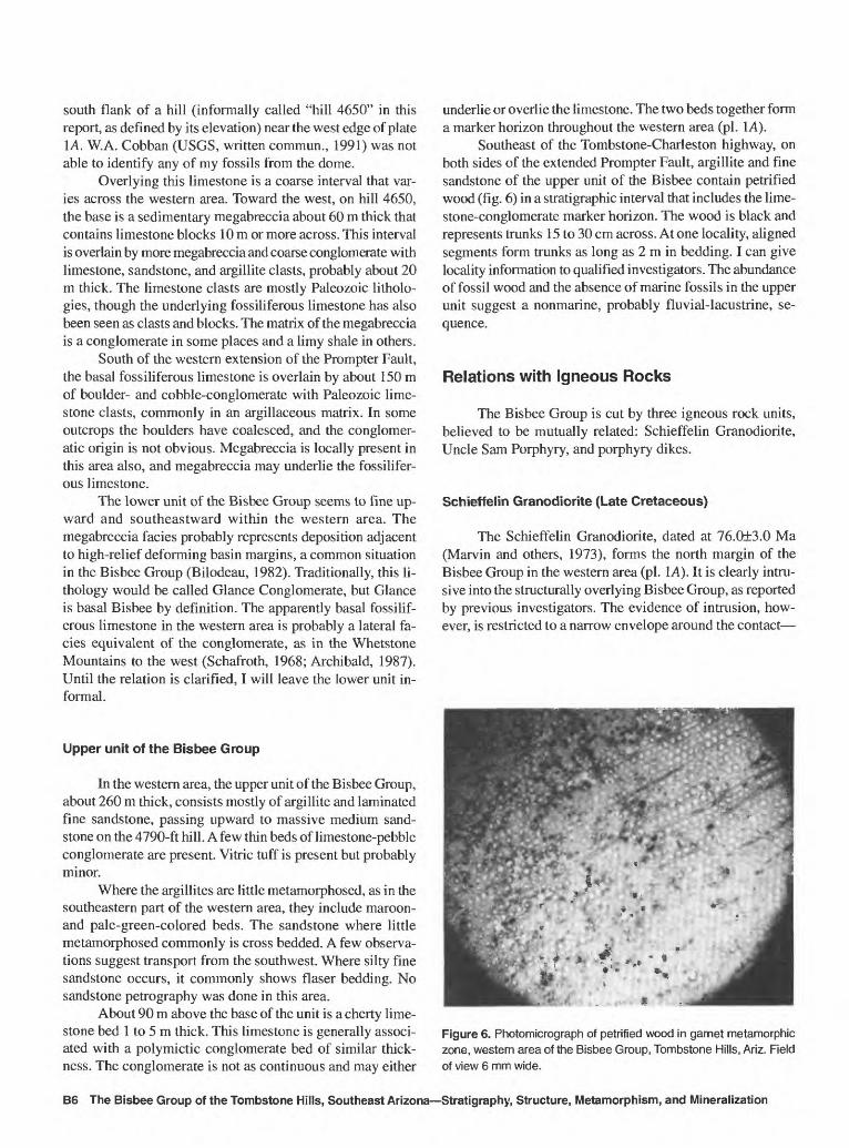
Lipman and Sawyer (1985) proposed a Late Cretaceous caldera in the western Tombstone Hills, which was based on reconnaissance work with the Uncle Sam Porphyry. The Bisbee Group in the western area of this report would form part of the caldera floor.
0 1 CENTIMETER
-^ Figure 2. Spotted hornfelses in contact-metamorphic zones
developed from the Bisbee Group, Tombstone Hills, Ariz. A, garnet spots; B, epidote spots; C, garnet-filled matrix around epidote cores, separated by carbonate rims.
Introduction B3
Drewes (1981, fig. 10) remapped (with C.H. Thorman) a small area near the intersection of the Ajax Hill and Prompter Faults. Williams (1980) described some rare min erals in Tombstone ores. Moore (1991) mapped the Fairbank quadrangle to the west, and he described the Laramide vol canic context of the Tombstone region (Moore, 1993).
This Study
In this study I use a broad stratigraphic framework for the Bisbee Group (fig. 3), along with contact-metamorphic zonation (fig. 4), to establish in greater detail the structural,
intrusive, and lithologic context of mineralization. Geologic mapping is shown on plate 1 at 1:12,000; that within the Bisbee Group is mostly new, and the remainder has been field checked. The western area was studied first, and is pre sented first, because its structures are not so complex that stratigraphic sequences are dismembered. The sequence de ciphered from the western area was then used as a template for the Tombstone Basin area.
Data from 11 drill holes helped me determine cross- sectional relations shown on plate 1. Contact-metamorphic zones on plate IB are based on field observations supported by study of about 50 thin sections. In the Tombstone Basin area, features shown by Butler and others (1938), replotted
WESTERN AREA
NW SE
METERS
r500
- 400
-300
TOMBSTONE BASIN
SW
METERS
700 -i
NE
600 - ' . .'; : :.- .. . ' '> -^
Upper unit
of the
500-
400-
--200 marker.
Bisbee Group300-
Lower unitof the
Bisbee Group
EXPLANATION
oo oO
- - - - -/Joe limestone- - - - - -'-^r T ~ -/ i l i l l l l I I I T
Marker limestone with associated conglomerate
Conglomerate, diagrammatically showing clast size distribution
Figure 3. Schematic stratigraphic framework of the Bisbee Group in Tombstone Hills, Ariz. Horizontal distance not to scale.
B4 The Bisbee Group of the Tombstone Hills, Southeast Arizona Stratigraphy, Structure, Metamorphism, and Mineralization
on the 1908 base, served to guide my mapping and to con trol the approximate location of their unplotted cross sec tions for my structural contouring.
Acknowledgments
I thank Santa Fe Pacific Mining, Inc., for giving permis sion to use drill-hole logs and examine cores (holes T1-T6 and
W
Western area Tombstone Basin Unmetamorphosed _ ?_?_?
EP>130m Group
EP,EP,
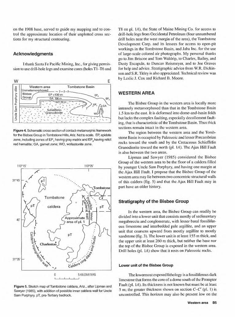
Figure 4. Schematic cross section of contact-metamorphic framework
for the Bisbee Group in Tombstone Hills, Ariz. Motto scale. EP, epidote
zone, including zones of EP1 having gray matrix and EP2 having relict
red hematite; GA, garnet zone; WO, wollastonite zone.
110°05'
31°45'
40'
31°35'
5 KILOMETERS
Figure 5. Sketch map of Tombstone caldera, Ariz., after Lipman and Sawyer (1985), with addition of possible inner caldera wall for Uncle Sam Porphyry. pT, pre-Tertiary bedrock.
T8 on pi. 1A), the State of Maine Mining Co. for access to drill-hole logs from Occidental Petroleum (four unnumbered drill holes near the west margin of the area), the Tombstone Development Corp. and its lessees for access to open-pit workings in the Tombstone Basin, and Jaba Inc. for the use of large-scale colored air photographs. My personal thanks go to Jim Briscoe and Tom Waldrip, to Charles, Bailey, and Dusty Escapule, to Duncan Reismeyer, and to Joe Graves for help and advice. Stratigraphic advice from W.R. Dickin- son and S.R. Titley is also appreciated. Technical review was by Leslie J. Cox and Richard B. Moore.
WESTERN AREA
The Bisbee Group in the western area is locally more intensely metamorphosed than that in the Tombstone Basin 1.5 km to the east. It is deformed into dome-and-basin folds but lacks the complex faulting, especially decollement fault ing, that is characteristic of the Tombstone Basin. Thus thick sections remain intact in the western area.
The region between the western area and the Tomb stone Basin is occupied by Paleozoic and lesser Precambrian rocks toward the south and by the Cretaceous Schieffelin Granodiorite toward the north (pi. 1A). The Ajax Hill Fault is also between the two areas.
Lipman and Sawyer (1985) considered the Bisbee Group of the western area to be the floor of a caldera filled by younger Uncle Sam Porphyry, and having one margin at the Ajax Hill Fault. I propose that the Bisbee Group of the western area may lie between two concentric structural walls of this caldera (fig. 5) and that the Ajax Hill Fault may in part have an older history.
Stratigraphy of the Bisbee Group
In the western area, the Bisbee Group can readily be divided into a lower unit that consists mostly of sedimentary megabreccia and conglomerate, with lesser basal fossilifer- ous limestone and interbedded pale argillite, and an upper unit that coarsens upward from mostly argillite to mostly sandstone (fig. 3). The lower unit is at least 155 m thick, and the upper unit at least 260 m thick, but neither the base nor the top of the Bisbee Group is exposed in the western area. Drill holes (pi. 1A) show that it rests on Paleozoic rocks.
Lower unit of the Bisbee Group
The lowermost exposed lithology is a fossiliferous dark limestone that forms the core of a dome south of the Prompter Fault (pi. 1A). Its thickness is not known but must be at least 5 m; the greater thickness shown on section C-C (pi. 1) is uncontrolled. This horizon may also be present low on the
Western area B5
south flank of a hill (informally called "hill 4650" in this report, as defined by its elevation) near the west edge of plate 1A. W.A. Cobban (USGS, written commun., 1991) was not able to identify any of my fossils from the dome.
Overlying this limestone is a coarse interval that var ies across the western area. Toward the west, on hill 4650, the base is a sedimentary megabreccia about 60 m thick that contains limestone blocks 10 m or more across. This interval is overlain by more megabreccia and coarse conglomerate with limestone, sandstone, and argillite clasts, probably about 20 m thick. The limestone clasts are mostly Paleozoic litholo- gies, though the underlying fossiliferous limestone has also been seen as clasts and blocks. The matrix of the megabreccia is a conglomerate in some places and a limy shale in others.
South of the western extension of the Prompter Fault, the basal fossiliferous limestone is overlain by about 150 m of boulder- and cobble-conglomerate with Paleozoic lime stone clasts, commonly in an argillaceous matrix. In some outcrops the boulders have coalesced, and the conglomer atic origin is not obvious. Megabreccia is locally present in this area also, and megabreccia may underlie the fossilifer ous limestone.
The lower unit of the Bisbee Group seems to fine up ward and southeastward within the western area. The megabreccia facies probably represents deposition adjacent to high-relief deforming basin margins, a common situation in the Bisbee Group (Bilodeau, 1982). Traditionally, this li- thology would be called Glance Conglomerate, but Glance is basal Bisbee by definition. The apparently basal fossilif erous limestone in the western area is probably a lateral fa cies equivalent of the conglomerate, as in the Whetstone Mountains to the west (Schafroth, 1968; Archibald, 1987). Until the relation is clarified, I will leave the lower unit in formal.
Upper unit of the Bisbee Group
In the western area, the upper unit of the Bisbee Group, about 260 m thick, consists mostly of argillite and laminated fine sandstone, passing upward to massive medium sand stone on the 4790-ft hill. A few thin beds of limestone-pebble conglomerate are present. Vitric tuff is present but probably minor.
Where the argillites are little metamorphosed, as in the southeastern part of the western area, they include maroon- and pale-green-colored beds. The sandstone where little metamorphosed commonly is cross bedded. A few observa tions suggest transport from the southwest. Where silty fine sandstone occurs, it commonly shows flaser bedding. No sandstone petrography was done in this area.
About 90 m above the base of the unit is a cherty lime stone bed 1 to 5 m thick. This limestone is generally associ ated with a polymictic conglomerate bed of similar thick ness. The conglomerate is not as continuous and may either
underlie or overlie the limestone. The two beds together form a marker horizon throughout the western area (pi. 1A).
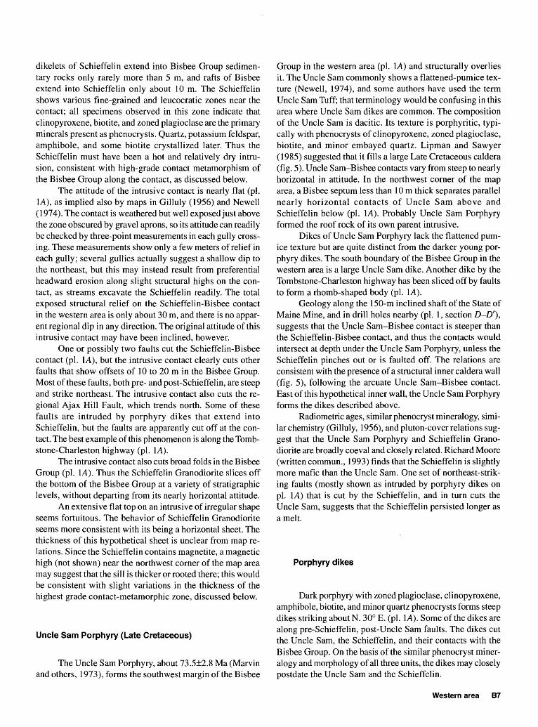
Southeast of the Tombstone-Charleston highway, on both sides of the extended Prompter Fault, argillite and fine sandstone of the upper unit of the Bisbee contain petrified wood (fig. 6) in a stratigraphic interval that includes the lime stone-conglomerate marker horizon. The wood is black and represents trunks 15 to 30 cm across. Atone locality, aligned segments form trunks as long as 2 m in bedding. I can give locality information to qualified investigators. The abundance of fossil wood and the absence of marine fossils in the upper unit suggest a nonmarine, probably fluvial-lacustrine, se quence.
Relations with Igneous Rocks
The Bisbee Group is cut by three igneous rock units, believed to be mutually related: Schieffelin Granodiorite, Uncle Sam Porphyry, and porphyry dikes.
Schieffelin Granodiorite (Late Cretaceous)
The Schieffelin Granodiorite, dated at 76.0±3.0 Ma (Marvin and others, 1973), forms the north margin of the Bisbee Group in the western area (pi. 1A). It is clearly intru sive into the structurally overlying Bisbee Group, as reported by previous investigators. The evidence of intrusion, how ever, is restricted to a narrow envelope around the contact
Figure 6. Photomicrograph of petrified wood in garnet metamorphic zone, western area of the Bisbee Group, Tombstone Hills, Ariz. Field of view 6 mm wide.
B6 The Bisbee Group of the Tombstone Hills, Southeast Arizona Stratigraphy, Structure, Metamorphism, and Mineralization
dikelets of Schieffelin extend into Bisbee Group sedimen tary rocks only rarely more than 5 m, and rafts of Bisbee extend into Schieffelin only about 10 m. The Schieffelin shows various fine-grained and leucocratic zones near the contact; all specimens observed in this zone indicate that clinopyroxene, biotite, and zoned plagioclase are the primary minerals present as phenocrysts. Quartz, potassium feldspar, amphibole, and some biotite crystallized later. Thus the Schieffelin must have been a hot and relatively dry intru sion, consistent with high-grade contact metamorphism of the Bisbee Group along the contact, as discussed below.
The attitude of the intrusive contact is nearly flat (pi. 1A), as implied also by maps in Gilluly (1956) and Newell (1974). The contact is weathered but well exposed just above the zone obscured by gravel aprons, so its attitude can readily be checked by three-point measurements in each gully cross ing. These measurements show only a few meters of relief in each gully; several gullies actually suggest a shallow dip to the northeast, but this may instead result from preferential headward erosion along slight structural highs on the con tact, as streams excavate the Schieffelin readily. The total exposed structural relief on the Schieffelin-Bisbee contact in the western area is only about 30 m, and there is no appar ent regional dip in any direction. The original attitude of this intrusive contact may have been inclined, however.
One or possibly two faults cut the Schieffelin-Bisbee contact (pi. 1A), but the intrusive contact clearly cuts other faults that show offsets of 10 to 20 m in the Bisbee Group. Most of these faults, both pre- and post-Schieffelin, are steep and strike northeast. The intrusive contact also cuts the re gional Ajax Hill Fault, which trends north. Some of these faults are intruded by porphyry dikes that extend into Schieffelin, but the faults are apparently cut off at the con tact. The best example of this phenomenon is along the Tomb stone-Charleston highway (pi. 1A).
The intrusive contact also cuts broad folds in the Bisbee Group (pi. 1A). Thus the Schieffelin Granodiorite slices off the bottom of the Bisbee Group at a variety of stratigraphic levels, without departing from its nearly horizontal attitude.
An extensive flat top on an intrusive of irregular shape seems fortuitous. The behavior of Schieffelin Granodiorite seems more consistent with its being a horizontal sheet. The thickness of this hypothetical sheet is unclear from map re lations. Since the Schieffelin contains magnetite, a magnetic high (not shown) near the northwest corner of the map area may suggest that the sill is thicker or rooted there; this would be consistent with slight variations in the thickness of the highest grade contact-metamorphic zone, discussed below.
Uncle Sam Porphyry (Late Cretaceous)
The Uncle Sam Porphyry, about 73.5±2.8 Ma (Marvin and others, 1973), forms the southwest margin of the Bisbee
Group in the western area (pi. 1A) and structurally overlies it. The Uncle Sam commonly shows a flattened-pumice tex ture (Newell, 1974), and some authors have used the term Uncle Sam Tuff; that terminology would be confusing in this area where Uncle Sam dikes are common. The composition of the Uncle Sam is dacitic. Its texture is porphyritic, typi cally with phenocrysts of clinopyroxene, zoned plagioclase, biotite, and minor embayed quartz. Lipman and Sawyer (1985) suggested that it fills a large Late Cretaceous caldera (fig. 5). Uncle Sam-Bisbee contacts vary from steep to nearly horizontal in attitude. In the northwest corner of the map area, a Bisbee septum less than 10m thick separates parallel nearly horizontal contacts of Uncle Sam above and Schieffelin below (pi. 1A). Probably Uncle Sam Porphyry formed the roof rock of its own parent intrusive.
Dikes of Uncle Sam Porphyry lack the flattened pum ice texture but are quite distinct from the darker young por phyry dikes. The south boundary of the Bisbee Group in the western area is a large Uncle Sam dike. Another dike by the Tombstone-Charleston highway has been sliced off by faults to form a rhomb-shaped body (pi. 1A).
Geology along the 150-m inclined shaft of the State of Maine Mine, and in drill holes nearby (pi. 1, section D-D'}, suggests that the Uncle Sam-Bisbee contact is steeper than the Schieffelin-Bisbee contact, and thus the contacts would intersect at depth under the Uncle Sam Porphyry, unless the Schieffelin pinches out or is faulted off. The relations are consistent with the presence of a structural inner caldera wall (fig. 5), following the arcuate Uncle Sam-Bisbee contact. East of this hypothetical inner wall, the Uncle Sam Porphyry forms the dikes described above.
Radiometric ages, similar phenocryst mineralogy, simi lar chemistry (Gilluly, 1956), and pluton-cover relations sug gest that the Uncle Sam Porphyry and Schieffelin Grano diorite are broadly coeval and closely related. Richard Moore (written commun., 1993) finds that the Schieffelin is slightly more mafic than the Uncle Sam. One set of northeast-strik ing faults (mostly shown as intruded by porphyry dikes on pi. 1A) that is cut by the Schieffelin, and in turn cuts the Uncle Sam, suggests that the Schieffelin persisted longer as a melt.
Porphyry dikes
Dark porphyry with zoned plagioclase, clinopyroxene, amphibole, biotite, and minor quartz phenocrysts forms steep dikes striking about N. 30° E. (pi. 1A). Some of the dikes are along pre-Schieffelin, post-Uncle Sam faults. The dikes cut the Uncle Sam, the Schieffelin, and their contacts with the Bisbee Group. On the basis of the similar phenocryst miner alogy and morphology of all three units, the dikes may closely postdate the Uncle Sam and the Schieffelin.
Western area B7
Metamorphism Structure
Intrusion of the Schieffelin Granodiorite and, to a lesser extent, the large dike of Uncle Sam Porphyry have meta morphosed rocks of the Bisbee Group to various degrees (pi. IB). The metamorphism is entirely static contact metamor- phism; hornfelses show no synchronous deformation, and their sedimentary structures are commonly preserved. Petri fied wood, for example, retains its microscopic structure in the garnet zone (fig. 6). Many hornfelses have spotted tex tures (fig. 2) and colors may vary from light to dark along the strike of argillite beds.
Metamorphic grades range from apparently unal tered rocks to the wollastonite-diopside-garnet assemblage (hornblende-hornfels facies). Metamorphic zones (pi. IB) are delineated on the basis of calcic assemblages; aluminous as semblages are most commonly retrograde. The total thick ness of metamorphosed rocks is about 250 m.
The wollastonite-diopside-garnet assemblage (wollas- tonite zone of pi. IB) is favored in calcic rocks, but parts of the assemblage are present in less calcic rocks with cordier- ite and secondary feldspar. The zone containing this mineral assemblage is everywhere in contact with the Schieffelin Granodiorite. The structural thickness of the zone is appar ently about 20 to 30 m, and the greater thicknesses are to ward the northwest end of the intrusive contact (pi. IB). Spot ted textures are not common in this zone.
A garnet zone occupies a large area of the Bisbee Group in the western area (pi. IB). The composition of the garnet was not checked but is probably grossularite or andradite. Rocks of several types show garnet either in calcic spots or as part of a matrix in rocks where the spots are epidotic (fig. 2A, C). The garnet in argillite is locally very fine and im parts a creamy appearance to the rock. The zone shown on plate \B is defined by the presence of garnet but the absence of wollastonite or diopside in calcic assemblages. The thick ness of the zone is at least 100 m on hill 4790. The great extent of this zone to the southwest suggests that the Schieffelin Granodiorite is present at shallow depth, as would be expected from the horizontal attitude of its upper surface, at least to the Uncle Sam-Bisbee contacts and the Prompter Fault.
An epidote zone is defined by a variety of rocks in the southern part of the western area. In outcrop, epidote is most obvious in spotted hornfelses (fig. 2B) and as rims or com plete replacements of limestone pebbles in conglomerate. The thickness of the epidote zone in this area is unclear, but it is probably about 130 m (if the interpretation in section C-C' of plate 1 is correct). Two areas of rocks south of the ex tended Prompter Fault apparently contain no contact-meta- morphic minerals (pi. IB). Along the south margin of the map area, epidote-bearing rocks against the Uncle Sam Por phyry dike suggest that metamorphism is locally caused by the dike. The contrast of metamorphic grades across the Prompter Fault is discussed below.
The overall structure of the Bisbee Group in the west ern area is a set of dome-and-basin folds, cut mostly by north east-striking faults. All the folds and most faults apparently preceded intrusion of Schieffelin Granodiorite. The Prompter Fault probably has both pre- and post-Schieffelin movement.
Folds
Large open upright folds in the Bisbee Group form a dome-and-basin or egg-box pattern in the western area (pi. I A). Where the fold axes can be traced, they trend about S. 45° to 60° E. and N. 30° E. At the south end of the area, the former set forms a tighter southeast-plunging anticline.
The largest fold is a basin formed by intersecting broad synclines just north of the Tombstone-Charleston highway. Its position is approximately marked by structural attitudes, but satellitic dip reversals occur. The basin is partially out lined by the cherty limestone marker horizon (pi. 1A). South of the Prompter Fault, anticlines are more prominent, and fold intersections have formed a broad dome marked by the megabreccia in the lower unit of the Bisbee Group.
Northeast-striking faults
Steep northeast-striking faults (and a related northwest- striking fault north of hill 4790), some intruded by porphyry, are the most obvious faults in the Bisbee Group of the west ern area (pi. 1A). A few of these faults are mineralized.
This set of faults appears to be pre-Schieffelin except in two places but apparently cuts the Uncle Sam-Bisbee con tact in six places. Thus faulting of this type appears to be broadly synchronous with Schieffelin-Uncle Sam emplace ment. The faults may also be approximately synchronous with folding; note the similar sense of the folding and fault ing north of hill 4790 (pi. 1A). Some fault movement may be synchronous with Bisbee Group accumulation; the cherty limestone marker horizon is thicker or splits into multiple horizons on the downthrown side of some of the faults in this same area.
Ajax Hill Fault
As noted by previous investigators, the north-south Ajax or Ajax Hill Fault juxtaposes Bisbee Group to the west against Paleozoic rocks to the east (pi. 1A). It is an older
B8 The Bisbee Group of the Tombstone Hills, Southeast Arizona Stratigraphy, Structure, Metamorphism, and Mineralization
structure cut by both the Schieffelin Granodiorite and the Prompter Fault (and its branches).
tiary rhyolite (not shown) in Paleozoic rocks farther to the east. This alternative is shown in cross section C-C (pi. 1).
Prompter Fault
The Prompter Fault is a major structure that generally separates younger rocks, including the Bisbee Group of the Tombstone Basin to the north, from an east-dipping sequence of older Precambrian and Paleozoic rocks to the south. Pre vious investigators realized that the Prompter must cut the Bisbee Group but were unable to trace this extension. The task was made more difficult by the presence of four strands of the fault at its west end, where it intersects the Ajax Hill Fault (pi. IA; see also Drewes, 1981, fig. 10).
The stratigraphy and metamorphism of the Bisbee Group established in this study permit the tracing of the fault and show that only one strand, the northernmost, is impor tant in the Bisbee Group. It juxtaposes the upper unit to the north against the lower unit to the south (pi. 1A) but also juxtaposes garnet- and epidote-zone rocks to the north against epidote-zone and unmetamorphosed rocks to the south (pi. IB). The stratigraphic offset suggests that the north side is downthrown, but the metamorphism suggests the south side is downthrown, assuming that metamorphism is controlled by proximity to underlying Schieffelin Granodiorite.
Several solutions to this problem deserve consideration. (1) Some igneous rock not presently exposed may have formed a structurally overlying sheet, metamorphosing the Bisbee Group in this area from the top down. (2) Strike-slip movement on the Prompter Fault may have juxtaposed un related geologic situations. (3) The upper margin of the Schieffelin intrusive sheet may have stepped down to the south along the (older) Prompter Fault. (4) Movement on the Prompter Fault may have taken place in two stages, one before and one after intrusion of Schieffelin Granodiorite. There is no evidence elsewhere for the first hypothesis, so it becomes a special plea. The second solution violates the modest lateral offset of the Ajax Hill Fault. I therefore prefer some combination of the third and fourth solutions; both re quire pre-Schieffelin movement along the Prompter. The third solution is consistent with the apparently pre-Uncle Sam age of the fault (pi. 1A); it implies pre-Schieffelin movement on the Prompter, followed by Schieffelin intrusion with a down- to-south step along the fault plane. The fourth solution im plies the following chronology. Pre-Schieffelin movement on the Prompter Fault brought the south side up, such that the stratigraphic separation was about 100 m more than at present. Then intrusion of the Schieffelin planed off the bot tom of the Bisbee Group on a subhorizontal surface. Subse quent movement on the Prompter Fault was up on the north to produce the current relations. A second, post-Schieffelin stage of movement on the Prompter Fault is in accord with the observation by Newell (1974) that the Prompter cuts Ter-
Mineralization
The Bisbee Group in the western area is not as strongly mineralized as in the Tombstone Basin. Numerous shafts and adits remain open (and unsafe), but production (Keith, 1973) was modest.
Mineralization generally occurs along steep faults as lensoid quartz veins and thin selvages of sheared and altered wallrock, including porphyry dikes. Manganese oxide coat ings are prominent. Deposits are grouped by associated struc tures for description. Those along northeast-striking faults are described from southeast to northwest.
A northeast-striking set of steep faults offsets the lime stone-conglomerate marker horizon and slices an Uncle Sam dike into a rhomboid pattern between the Tombstone-Charles ton highway and the Prompter Fault (pi. 1A). Some of the faults are intruded by porphyry dikes. Mineralization includes amethystine quartz and postdates both the Uncle Sam Por phyry and younger porphyry dikes. Named workings on this structure include the Mamie and Sailor Mines. Production was a few hundred tons of silver ore.
A northeast-striking steep fault passes through the saddle southeast of hill 4790. Northeastward it branches, and each branch offsets the limestone-conglomerate marker ho rizons slightly but is in turn cut by the Schieffelin Grano diorite. Black hornfelses are oxidized along the faults. Many of the workings are part of the Soltice claim block (scattered along this fault and the following set but not shown on plate1).
Another northeast-striking fault set dips northwest and cuts the Uncle Sam-Bisbee contact east of the State of Maine Mine. One segment contains a porphyry dike. Named work ings along this fault set include the Bonanza Mines and the remainder of the Soltice workings. Production (including all Soltice production) was about 4,500 tons of lead-silver ore.
About a half mile northwest of that set, a northeast- striking fault dips steeply northwest. It locally forms the boundary between the upper and lower units of the Bisbee Group and offsets Bisbee-Uncle Sam contacts. Little miner alization was seen, but this structure may extend to the State of Maine Mine, where parallel structures are mineralized. The Merrimac and Free Coinage workings are in a parallel structure about 200 m to the east but in the Uncle Sam Por phyry.
The western extension of the Prompter Fault is miner alized, especially in a northeast-striking segment. Workings at the Randolph Mine produced a few hundred tons of silver ore. In addition, the Dry Hill (or Silver Cable) Mines are near the intersection of the Prompter and Ajax Hill Faults. They may have produced as much as 10,000 tons of manganiferous silver ore. Newell (1974) found anomalous
Western area B9
base- and precious-metal values in the area of this intersec tion. To the east, the Prompter Fault is associated with silver and manganese mineralization in Paleozoic rocks at the Prompter, Oregon, and Bunker Hill Mines.
Mineralization in the western area of the Bisbee Group thus follows premineralization faults that themselves post date porphyry dikes. These dikes are the youngest igneous features of that area. It appears that mineralization is un likely to be associated with intrusion of the Schieffelin Gra- nodiorite and could be much younger.
greatest thickness of the Bisbee occurs not in the axis of the structural basin, but in strata piled against the southeast mar gin of the Tombstone Basin.
Depositional contacts of the Bisbee Group with Pa leozoic units are locally exposed along the southwest mar gin of the Tombstone Basin and in subsurface records of Butler and others (1938). The top of the group is not ex posed. Thus true thicknesses can be specified for the lower unit but not the upper unit.
Basal unconformity
TOMBSTONE BASIN
The Tombstone Basin is a structural rather than a to pographic feature; topographic relief within it is about 150 m whereas structural relief is more than 460 m. The basin is defined by the outcrop pattern of the Bisbee Group (pi. 1A). Its margin is against Paleozoic rocks to the south and south west and against Schieffelin Granodiorite to the west; to the north and east the margin is covered by Cenozoic deposits. The Tombstone Basin area is structurally much more com plex than the western area.
Stratigraphy of the Bisbee Group
As in the western area, the Bisbee Group in the Tomb stone Basin can be divided into two units (fig. 3). The upper unit is similar to that of the western area. The lower unit, though clearly the same entity as in the western area, has acquired some different characteristics through facies changes. A marker horizon shared by the two areas permits correlation within the upper unit.
Butler and others (1938) listed a detailed stratigraphic sequence for the Bisbee Group in the Tombstone Basin, ag gregating 3,115 ft (950 m). Gilluly (1956) gave a thickness of 3,079 ft (939 m). These authors apparently assumed that strata in the Tombstone Extension district are the highest in the section, whereas my structural data suggest that these strata duplicate parts of the section present elsewhere. In addition, decollements and other structures (pi. 1) that were previously unmapped complicate the section. I obtain a total thickness of about 430 m in the center of the basin; this is derived for the lower part (up to the limestone marker hori zon) from drill-hole constraints (section F-F', pi. 1) and for the upper part from estimation of structural thickness in the axis of the basin, corrected for stratigraphic repetition on the Gird Fault. Composite measurements of maximum exposed thicknesses of each unit in the southeastern part of the basin yield a total thickness of 670 m, however. Apparently, the
The southwest margin of the Tombstone Basin is the only part of the Tombstone area where the basal unconformity of the Bisbee Group is well exposed. In outcrop the unconformity is not obvious; it is between carbonate rocks of the Pennsylvanian and Permian Naco Group and basal calcareous argillites of the Bisbee Group. Paleosoils were not observed. Across the area of the Tombstone Basin, drill records show that the Bisbee Group rests on progressively lower formations of the Naco Group toward the east.
Lower unit of the Bisbee Group
In the Tombstone Basin the lower unit of the Bisbee Group is characterized (in order of abundance) by limestone- pebble conglomerate, pale argillite, quartzite, and fossilifer- ous limestone (especially the so-called Blue limestone). Any of these lithologies may be silicified locally; in the southern outskirts of the town of Tombstone, silicification of all these lithologies except the Blue limestone is intense. Primary fa cies change is also considerable; vertical succession will be described in two different areas.
In the strike belt of Luck Sure hill (local name, pi. 1), the basal lithology of the lower unit is a pale argillite as thick as 15 m that rests on Permian carbonate rocks. Overlying the argillite is conglomerate having pebbles as large as 10 cm that consist of volcanic rocks, limestone, and argillite, commonly silicified. The conglomerate varies in thickness from about 10 m to about 100 m. Overlying the conglomer ate is a succession of thin limestone beds and bleached argil lite, locally silicified or adularia-bearing (called "novacu- lite" in earlier studies), that extends to the top of the lower unit. The first limestone bed above conglomerate commonly contains fossils. The total thickness of the lower unit in this section is about 170 m. To the north, toward the Lucky Cuss Mine, the conglomerate thins rapidly and is overlain by thick limestone beds, pale argillite, and fine quartzite. Toward the south, the conglomerate also begins to thin, and where the lower unit disappears the conglomerate is only 2 m thick and contains quartz pebbles. Northeastward, in successive drill holes, the lower unit thins from about 170 m to about
B10 The Bisbee Group of the Tombstone Hills, Southeast Arizona Stratigraphy, Structure, Metamorphism, and Mineralization
50 m (cross section E-E', pi. 1). Maximum pebble size de creases in this sequence from 10 cm to 3 cm.
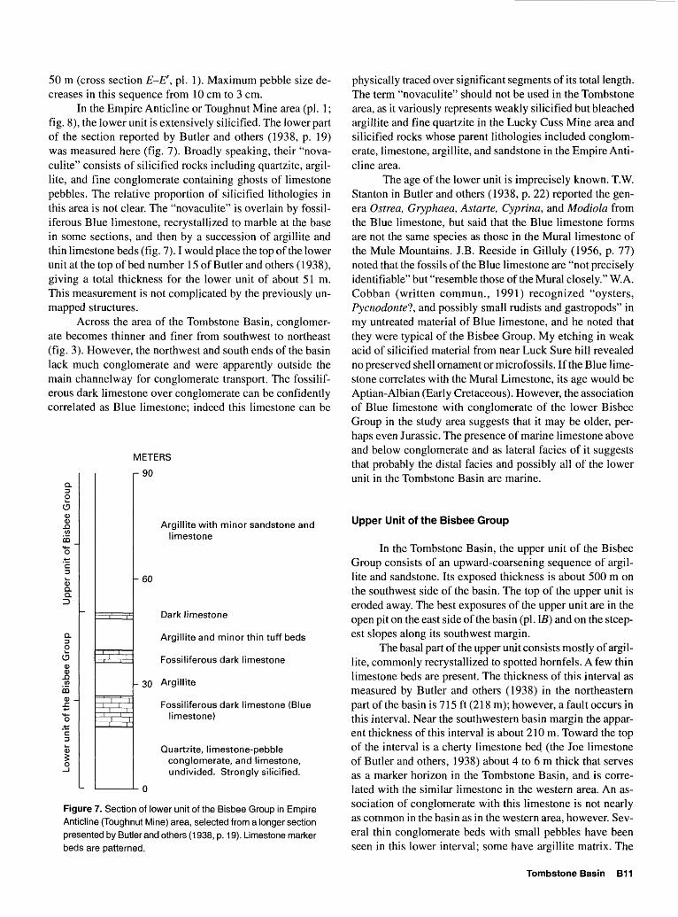
In the Empire Anticline or Toughnut Mine area (pi. 1; fig. 8), the lower unit is extensively silicified. The lower part of the section reported by Butler and others (1938, p. 19) was measured here (fig. 7). Broadly speaking, their "nova- culite" consists of silicified rocks including quartzite, argil- lite, and fine conglomerate containing ghosts of limestone pebbles. The relative proportion of silicified lithologies in this area is not clear. The "novaculite" is overlain by fossil- iferous Blue limestone, recrystallized to marble at the base in some sections, and then by a succession of argillite and thin limestone beds (fig. 7). I would place the top of the lower unit at the top of bed number 15 of Butler and others (1938), giving a total thickness for the lower unit of about 51m. This measurement is not complicated by the previously un mapped structures.
Across the area of the Tombstone Basin, conglomer ate becomes thinner and finer from southwest to northeast (fig. 3). However, the northwest and south ends of the basin lack much conglomerate and were apparently outside the main channelway for conglomerate transport. The fossilif- erous dark limestone over conglomerate can be confidently correlated as Blue limestone; indeed this limestone can be
METERS
aDO
aCDCD.aw
CO _M
o'ED
CDQ.a
aDO
aCDCD
-Q(A
CO1"
'ED
CD5o
i i
i ii ii i~+-^
i- 90
ArrMIL
li
- 60
Da
ArrMIL
Fos
- 30 Arc
Fos li
QuQ
u
n
Argillite with minor sandstone and limestone
Dark limestone
Argillite and minor thin tuff beds
Fossiliferous dark limestone
Fossiliferous dark limestone (Blue limestone)
Quartzite, limestone-pebble conglomerate, and limestone, undivided. Strongly silicified.
Figure 7. Section of lower unit of the Bisbee Group in Empire Anticline (Toughnut Mine) area, selected from a longer section presented by Butler and others (1938, p. 19). Limestone marker beds are patterned.
physically traced over significant segments of its total length. The term "novaculite" should not be used in the Tombstone area, as it variously represents weakly silicified but bleached argillite and fine quartzite in the Lucky Cuss Mine area and silicified rocks whose parent lithologies included conglom erate, limestone, argillite, and sandstone in the Empire Anti cline area.
The age of the lower unit is imprecisely known. T.W. Stanton in Butler and others (1938, p. 22) reported the gen era Ostrea, Gryphaea, Astarte, Cyprina, and Modiola from the Blue limestone, but said that the Blue limestone forms are not the same species as those in the Mural limestone of the Mule Mountains. J.B. Reeside in Gilluly (1956, p. 77) noted that the fossils of the Blue limestone are "not precisely identifiable" but "resemble those of the Mural closely." W.A. Cobban (written commun., 1991) recognized "oysters, Pycnodontel, and possibly small rudists and gastropods" in my untreated material of Blue limestone, and he noted that they were typical of the Bisbee Group. My etching in weak acid of silicified material from near Luck Sure hill revealed no preserved shell ornament or microfossils. If the Blue lime stone correlates with the Mural Limestone, its age would be Aptian-Albian (Early Cretaceous). However, the association of Blue limestone with conglomerate of the lower Bisbee Group in the study area suggests that it may be older, per haps even Jurassic. The presence of marine limestone above and below conglomerate and as lateral facies of it suggests that probably the distal facies and possibly all of the lower unit in the Tombstone Basin are marine.
Upper Unit of the Bisbee Group
In the Tombstone Basin, the upper unit of the Bisbee Group consists of an upward-coarsening sequence of argil lite and sandstone. Its exposed thickness is about 500 m on the southwest side of the basin. The top of the upper unit is eroded away. The best exposures of the upper unit are in the open pit on the east side of the basin (pi. IB) and on the steep est slopes along its southwest margin.
The basal part of the upper unit consists mostly of argil lite, commonly recrystallized to spotted hornfels. A few thin limestone beds are present. The thickness of this interval as measured by Butler and others (1938) in the northeastern part of the basin is 715 ft (218 m); however, a fault occurs in this interval. Near the southwestern basin margin the appar ent thickness of this interval is about 210 m. Toward the top of the interval is a cherty limestone bed (the Joe limestone of Butler and others, 1938) about 4 to 6 m thick that serves as a marker horizon in the Tombstone Basin, and is corre lated with the similar limestone in the western area. An as sociation of conglomerate with this limestone is not nearly as common in the basin as in the western area, however. Sev eral thin conglomerate beds with small pebbles have been seen in this lower interval; some have argillite matrix. The
Tombstone Basin B11
open pit exposes several thin white tuff beds toward the base of the interval, and petrified wood has been found in two localities. Maroon siltstone is a common constituent of this interval where the metamorphic grade is low enough to per mit its preservation; however, these maroon siltstones com monly contain epidote spots in the southeastern part of the basin.
Sandstone forms the upper exposed part of the upper unit; the true nature of the top of the Bisbee Group is un known in the Tombstone area. The sandstone-dominated in terval is 145 to 290 m thick. Because of the basinal structure of the group, the only exposure of the upper interval is in the center of the basin, and thickness variations across the basin are unclear. Sandstone of this interval is mostly massive but commonly crossbedded, showing apparent transport from the northwest. Calcareous cement is partially recrystallized to epidotic spots. Some detrital feldspar, chert, and argillite are present.
Stratigraphic-Lithologic Summary
In the Tombstone Basin, the Bisbee Group is about 430 to 670 m thick. It consists toward the base of interbedded conglomerate, limestone, quartzite, and argillite, succeeded upward by an argillite-dominated interval and then by sand stone (fig. 3). The change in regime marked by the central argillitic interval may correspond to a change in transport direction from northeast to southeast. This may correspond to a change from marine conditions to fluvial conditions. The group is thicker and the basal interval is coarser toward the southwest.
The position of marine limestone immediately over basal conglomerate, and the lateral intertonguing of these lithologies in the Bisbee Group of the Tombstone Basin, is like the sequence in the Whetstone Mountains to the west (Schafroth, 1968; Archibald, 1987). This suggests an affin ity of the Bisbee Group of the Tombstone Hills with the north western facies of the group and suggests the presence of a sub-basin margin between the northern Tombstone Hills and the Mule Mountains to the southeast. In this light the megabreccia of the western area probably records fault ac tivity on such a margin.
Nine rocks of various types were chemically analyzed for trace elements and most major elements (table 1). These rocks form a stratigraphic progression through the Bisbee Group of the Tombstone Basin in the two areas of greatest mineralization. Rocks without obvious mineralization have very ordinary compositions. Argillite color seems little re lated to base-metal content, unlike typical variations in shale sequences. Dark color in argillite is probably a function of contact-metamorphic reduction rather than primary carbon content. However, some specimens show that bleached horn- fels lacks the pyrite of adjacent dark hornfels. Note among the major elements the high (secondary?) potash content of
the tuffaceous argillite (FA393) and the low alkali content of the limestone (FA 258).
Structure
Structural elements of the Tombstone Basin include, from younger to older, (1) basin-and-range faults, (2) the Tranquility and other east-dipping normal faults, (3) north east-striking fractures (fissures), (4) west-dipping normal faults intruded by porphyry dikes, (5) dome-and-basin folds, (6) decollements at several structural levels, and (7) tight northwest-trending upright to overturned folds (rolls) and related faults. Thus the geology of the Tombstone Basin has become quite complex. The history of igneous intrusion is best understood against the structural background in the Tombstone Basin, so the structural history is described first. Description is in the order listed above to aid incremental reconstruction.
Basin-and-Range Faults
The east boundary of the Tombstone Extension dis trict is a fault that juxtaposes Bisbee Group to the west against Cenozoic gravels to the east. The fault trends northwest and dips steeply northeast (pi. 1A). Throw is not known. A pos sibly related northeast-striking fault forms the west bound ary of outcrops in the Emerald Gulch area. In Grand Gulch to the south, this fault is intruded by unaltered vesicular oli- vine basalt (pi. 1A).
Tranquility and Related Faults
The Tranquility set of faults along the east edge of the Tombstone Hills (pi. 1A; fig. 8) strikes generally north-north east and dips steeply eastward. Relative motion is down on the east, by as much as 180 m on the set as a whole, but by as much as 110 m on individual strands, based on data of Butler and others (1938). The greatest offset is on an un named strand about 90 m east of, and parallel to, the Tran quility Fault (fig. 9). Among the offset features is the Con tention dike, which is known as the Empire dike to the north on the footwall (fig. 8). The relation of these faults to miner alization is unclear but is discussed with mineralization.
The abrupt swing in strike of the Tranquility Fault to ward the northeast, described by Butler and others (1938) north of the Tranquility shaft, is apparently an offset seg ment of an older decollement, described in "Decollements". The Tranquility may continue to the north, as suggested on plate 1, or it may follow the older structure. The latter alter native is suggested by structure contouring (fig. 8).
B12 The Bisbee Group of the Tombstone Hills, Southeast Arizona Stratigraphy, Structure, Metamorphism, and Mineralization
Table 1. Trace- and major-element composition of selected samples from the Bisbee Group in the Tombstone Basin, Arizona
[Inductively coupled plasma-atomic emission spectroscopy (ICP) analyses by P.H. Briggs. Flame atomic absorption analyses for Au only by C.A. Motooka. Elements not found at level of detection: B, Bi, Eu, Ge, Ho, Sn, Ta, U, W, and Zr]
ElementField No.
FA 244A FA 249 FA 258 FA 259 FA 263 FA 273 FA 280 FA 388 FA 393
Percentage of element
Al 6.2 6.8 1.1 9.0 4.5 1.5 8.5 8.9Ca 8.2 11. 36. 4.7 3.6 .27 .15 7.4Fe 1.2 3.3 .72 2.7 1.2 .86 3.1 1.7K 2.4 3.4 .39 4.0 3.8 1.2 3.4 3.4Mg - 1.3 1.6 .56 1.4 .45 .04 .96 1.4
Na .65 .52 .04 1.0 .75 .02 .10 1.5p............. .14 .06 <.005 .08 .03 .11 .05 .05Ti .26 .32 .04 .42 .14 .09 .15 .28
lent
Mn - 250 710 2,000 240 620 320 190 1,300 1,500Ag - <2 <2 <2 <2 <2 83 <2 <2 <2As <10 <10 <10 10 <10 100 36 21 46Au <1 <1 <1 <1 <1 1 <1 <1 <1Ba 780 650 250 700 1,200 92 430 100 2,800
Be - 2 2 <1 2 1 2 2 2 1Cd <2 <2 <2 <2 <2 100 <2 <2 <2Ce 50 44 17 80 30 17 42 78 63Co- 5 14 5 8 8 7 6 7 6Cr 23 28 6 46 16 60 32 7 2
Cu 3 13 6 8 32 380 27 10 33Ga ----- 13 15 4 20 9 5 20 21 14La 27 23 10 47 18 9 24 42 32Li 34 56 4 39 14 77 45 60 15Mo- <2 <2 <2 <2 <2 38 <2 <2 <2
Mb- <4 <4 <4 10 <4 <4 6 13 11Nd - 24 23 11 36 15 8 18 35 29Ni 7 8 4 20 5 9 10 4 2Pb - 18 22 <4 <4 5 2,100 15 14 22Sc 8 12 <2 14 4 <2 13 13 8
Sr - - 280 450 160 250 170 170 68 860 430Th ----- 11 7 5 13 5 <4 13 15 8V 30 80 8 67 25 82 59 51 27Y - 28 19 6 29 14 6 17 40 31Yb~ 3 2 <1 3 1 <1 2 3 2Zn~ 34 64 14 14 15 5,100 53 80 82
8.31.71.8 7.1
.54
.93
.07
.35
Parts per million of element
Field locations:FA 244A. Silicified and epidotic fine quartzite (novaculite of
Butler and others, 1938) near Lucky Cuss Mine; lower unitof Bisbee Group.
FA 249. Limestone- and volcanic-pebble conglomerate containingfine garnet, east flank of Luck Sure hill near drill holes T4and T6; lower unit of Bisbee Group.
FA 258. Cherty limestone (Joe limestone), west flank HardupHill, near drill hole Tl; upper unit of Bisbee Group.
FA 259. Spotted epidotic dark argillite, north flank of HardupHill near Tribute Mine; upper unit of Bisbee Group.
FA 263. Sandstone with calcareous cement, Reservoir hill; upper
part of upper unit of Bisbee Group. FA 273. Mineralized calcareous quartzite (novaculite of Butler and
others, 1938), Defence fissure near Toughnut Gulch; lower unitof Bisbee Group.
FA 280. Dark argillite, laminated and pyritic, Toughnut Mine area(fig 8) adjacent to Blue limestone; lower unit of Bisbee Group.
FA 388. Gray calcareous epidotic argillite, near Boss dike andformer Girard mill; lower part of upper unit of Bisbee Group.
FA 393. Pale pyritic felty-textured argillite, probably tuffaceous,north flank of Reservoir hill; upper unit of B isbee Group belowJoe limestone marker. B13
110°03
31°42'
EXPLANATION
Fault showing dip Dashed where ap proximate. Relative motion shown by U (upthrown) and D (downthrown)
Thrust fault Sawteeth on upper plate
Dike showing dip Dashed where ap proximate, queried where uncertain. U, upthrown wall; D, downthrown wall
Mineralized fissure
iH Stope
\Z\ Mine shaft
DH8o Drill hole and number
B14 The Bisbee Group of the Tombstone Hills, Southeast Arizona Stratigraphy, Structure, Metamorphism, and Mineralization
^ Figure 8. Structural contour map along top of Blue limestone in Tombstone mining district, Ariz., showing roll-type deposits, associated faults, dikes, and slopes in Blue limestone and "novaculite," mostly based on cross sections and other information in Butler and others (1938). Positions of cross sections were not plotted on any map by Butler and others but are along rolls and fissures whose trends are regular and whose locations are well constrained. Relations along a given roll crest are accurate. Locations of stopes from their plate 7 have been checked in their cross sections. Mine shafts are shown for location. Eroded area is that for which Blue limestone is missing. Positions of features shown here do not match those on plate 1>4 because they are shown at the top of the Blue limestone on this figure and at the surface on plate 1A
Northeast-Striking Fractures (Fissures)
Northeast-striking steep fractures without offsets are commonly mineralized in the Tombstone Basin and are con sequently well known. They were called fissures in the older mining literature. (Butler and others, 1938, use the terms "fissure" and "dike-fissure"; only the former is being de scribed here.) The fractures still contain open space locally; they are undeformed and postdate all porphyry dikes. Butler and others list 10 fissures; a few of them (Arizona Queen, Skip Shaft, 409, and Westside) are shown on figure 8. Except for their mineralization, they seem to have little sig nificance.
Faults Intruded by Dikes
Porphyry dikes intrude an extensive set of faults that also strike north-northeast but dip steeply west (pi. 1A). As movement on the intruded faults is up on the east every where (fig. 8), they are normal faults. Offset is typically about 15m but varies from about 0 to 30 m. In a few exposures, segments of these faults that have not been intruded by dikes are preserved (pi. 1A).
The intersection of the fault intruded by the Conten tion dike and the Tranquility Fault has produced some com plex relations in the area of the open pit. At deeper levels, the area between these structures is a horst, as shown by F.L. Ransome (pi. 8 of Butler and others, 1938). Above that in tersection, however, the intervening area must be a graben (fig. 9). This structural level is the one exposed at the present ground surface and on the floor of the open pit. The interfer ence of these structures has removed a large interval from the middle of the Bisbee Group along the Contention-Tran- quility trend.
Dome-and-Basin Folds
The Tombstone Basin as a structural feature is a prod uct of nearly upright synclines intersecting at high angles (pi. 1A). The above-described faulting clearly postdates this basinal folding, as the faults are not deformed. On the other hand, decollements described below are folded with bedding into basinal form, and must predate basinal folding.
The tighter of the two intersecting synclines, called the Hardup Syncline, can be traced through the hill of that name from the cherty Joe limestone on the northwest to the Tranquility Fault on the southeast (pi. 1A). Bedding attitudes measured at the open pit suggest that the axis of the Hardup Syncline plunges 22° toward S. 50° E. there, in a steep south west-dipping axial plane. Rocks on the southwest limb are locally overturned (pi. 1A).
Another syncline can be traced through the little hill east of the open pit and plunges 25° to 40° south-southeast. The two synclines must intersect just west of Emerald Gulch (pi. 1). The implication that this area is the deepest part of the basin is supported by a west-northwest plunge of minor folds in the Tombstone Extension district.
3700 -
0 50 METERS
Figure 9. Cross section (looking north) through area of Tranquility and Contention Mines, Ariz., modified from F.L. Ransome (in Butler and others, 1938, pi. 8), to which I have added an arbitrary marker horizon (or Gird Fault) in upper unit of the Bisbee Group. Relations at depth are from underground workings.
Tombstone Basin B15
Decollements
Among the major structures of the Tombstone Basin are the folded decollements. The lowest decollement, the arcuate Lucky Cuss Fault, had been mapped and described from Luck Sure hill to the Herschel Mine (Butler and others, 1938). Its trace as extended on plate 1A swings in strike al most 90°. The dip is steep to the east. The Lucky Cuss Fault toward its south end is nearly parallel to bedding in strike but intersects the dip of overturned bedding at about 30°; in this area the fault forms the structural base of the Bisbee Group for some distance at the surface. To the north the fault trace is in stratigraphically higher rocks and intersects bed ding strike at progressively higher angles. Between the Herschel and Ingersoll Mines the apparent fault movement is high-angle reverse, northeast over southwest. Restoration by removing effects of later folding suggests that this seg ment of the fault originated as a thrust fault. Drill-hole data (cross section F-F', pi. 1) are consistent with this interpreta tion.
A higher decollement, here named the Gird Fault, forms an even tighter arc in the upper unit of the Bisbee Group. On plate 1A it is shown as four segments offset by the younger Tranquility and Contention structures as in figure 9. The decollement in aggregate can be traced for about 1,700 m. It generally dips 45° to 60° southeast on the north limb of the later Hardup Syncline but is steep and locally overturned on the south limb of that structure. The decollement generally intersects bedding at a low angle, but the Joe limestone marker horizon intersects it at a high angle and has been offset such that fault motion can be seen as east side up, or northeast over southwest. As on the Lucky Cuss Fault, re construction indicates original thrust movement.
A still higher decollement is suggested by stratigraphic comparison of rocks in the hills west and east of the open pit. The fact that the uppermost sandstone is exposed only along the top and southeast sides of the eastern hill suggests that it has been uplifted relative to sandstone on the west side, despite later down-to-east motion on the east strand of the Tranquility Fault. This third thrust-decollement is im plied but only weakly documented by exposures in the inter vening open pit. If my interpretation is correct, the central part of the Tranquility-Contention structural trend is the lo cus of three generations of faulting.
The term "decollements" rather than "thrusts" is used for these faults because they seem to envelop domains of distinctive deformation style. Between the Lucky Cuss and Gird Faults is the domain of mineralized rolls and related faults, described below, that occupy a broad stratigraphic interval from the Naco Group to the upper unit of the Bisbee Group. In contrast, between the Gird Fault and the hypoth esized upper decollement, a few small folds are apparently rooted on faults (fig. 10) and are confined to the lower argil- lite interval of the upper unit of the Bisbee. The upper part of the upper unit, found only above the Gird Fault, is folded only into open upright synclines of the later dome-and-basin type.
Rolls and Related Faults
The geometry of northwest-trending folds in the north ern part of the Tombstone Basin is well known from cross sections in Butler and others (1938). One such fold is ex posed currently in the open pit (fig. 11). These folds, called "rolls" in the older mining literature, are upright to over-
N
Ground surface
Figure 10. Tracing from 1989 photo mosaic of north part of east wall of open pit (pi. 1), Tombstone Basin, Ariz., looking east. Fold above concealed Gird Fault is truncated by Contention dike and fault. Field of view about 200 m wide; structures dashed where approximate, dotted where concealed.
B16 The Bisbee Group of the Tombstone Hills, Southeast Arizona Stratigraphy, Structure, Metamorphism, and Mineralization
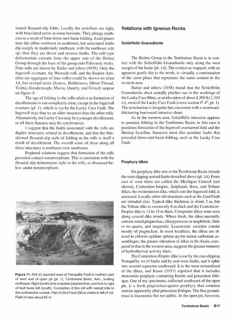
turned flexural-slip folds. Locally the anticlines are tight, with brecciated crests at some horizons. They plunge south east as a result of later dome-and-basin folding. Axial planes may dip either northeast or southwest, but associated faults dip steeply to moderately northeast, with the northeast side up; thus they are thrust and reverse faults. The roll-type deformation extends from the upper unit of the Bisbee Group through the base of the group into Paleozoic rocks. Nine rolls are shown by Butler and others (1938). Only the Ingersoll overturn, the Westside roll, and the Empire Anti cline (an aggregate of four rolls) could be shown on plate IA, but several more (Jeanes, Holderness, Silver Thread, Vizina, Goodenough, Macia, Quarry, and Girard) appear on figure 8.
The age of folding in the rolls relative to formation of decollements is not completely clear, except in the Ingersoll overturn (pi. 1), which is cut by the Lucky Cuss Fault. The Ingersoll may thus be an older structure than the other rolls. Alternatively, the Lucky Cuss may be a younger decollement, or all these features may be synchronous.
I suggest that the faults associated with the rolls are duplex structures related to decollement, and that the thin- skinned flexural-slip style of folding in the rolls is itself a result of decollement. The overall sense of shear along all these structures is northeast over southwest.
Regional relations suggest that formation of the rolls preceded contact metamorphism. This is consistent with the flexural-slip deformation style in the rolls, as discussed be low under metamorphism.
Figure 11. Roll (r) exposed west of Tranquility Fault in northern part of west wall of open pit (pi. 1), Tombstone Basin, Ariz., looking northwest. Right (north) limb is faulted (dashed line), and limb to right of fault faces left (south). Correlation of this roll with named rolls to the northwest is unclear. Part of Gird Fault (Gf) is visible to left of roll. Field of view about 60 m.
Relations with Igneous Rocks
Schieffelin Granodiorite
The Bisbee Group in the Tombstone Basin is in con tact with the Schieffelin Granodiorite only along the west margin of the basin (pi. IA). The contact as mapped, with an apparent gentle dip to the north, is virtually a continuation of the same plane that represents the same contact in the western area.
Butler and others (1938) found that the Schieffelin Granodiorite sheet actually pinches out in the workings of the Lucky Cuss Mine, at an elevation of about 4,300 ft (1,310 m), west of the Lucky Cuss Fault (cross section F-F', pi. 1). The termination is irregular but consistent with a westward- thickening horizontal intrusive sheet.
As in the western area, Schieffelin intrusion appears to postdate folding in the Tombstone Basin; in this case it postdates formation of the Ingersoll overturned fold and the Hardup Syncline. Intrusion must also postdate faults that preceded dome-and-basin folding, such as the Lucky Cuss Fault.
Porphyry dikes
Six porphyry dike sets in the Tombstone Basin intrude the west-dipping normal faults described above (pi. LA). From east to west these are called the Michigan Central (not shown), Contention-Empire, Sulphuret, Boss, and Tribute dikes; the westernmost dike, which cuts the Ingersoll fold, is unnamed. Locally other old structures such as the Gird Fault are intruded also. Typical dike thickness is about 3 m, but the Tribute dike is commonly 6 m thick and the Contention- Empire dike is 12 to 15 m thick. Composite dikes were seen along several dike trends. Where fresh, the dikes normally contain zoned plagioclase, clinopyroxene or amphibole, little or no quartz, and magnetite. Leucocratic varieties consist mostly of plagioclase. In most localities, the dikes are al tered to chlorite-epidote-sphene-pyrite-minor carbonate as semblages; the greater alteration of dikes in the basin, com pared to that in the western area, suggests the greater intensity of hydrothermal activity there.
The Contention-Empire dike is cut by the east-dipping Tranquility set of faults and by east-west faults, and it splits into several segments southward. It is the most mineralized of the dikes, and Rasor (1937) reported that it includes monzonite porphyry containing biotite and potassium feld spar. One of my specimens, collected southwest of the open pit, is a fresh plagioclase-quartz porphyry that contains sericite apparently after potassium feldspar. The fine ground- mass is leucocratic but not aplitic. In the open pit, however,
Tombstone Basin B17
the Contention-Empire dike is severely altered to quartz, talc, red iron oxide, and clay, to well below the deepest levels.
Dike intrusion must broadly postdate folding, as the dikes (and the faults they intrude) are undeformed. The bowed trace of the Tribute dike is permissive of some folding on the Hardup Syncline after intrusion. Ages of the dikes rela tive to the Schieffelin Granodiorite are unclear in the Tomb stone Basin, but the mutual relation of dikes and granodio- rite to folding is consistent with contemporaneity. The dikes are probably slightly later than the granodiorite, as in the western area.
Olivine Basalt Dike
A short 2-m-thick dike of vesicular oli vine basalt con taining obsidian xenoliths intrudes a possible basin-range fault in Grand Gulch (pi. I A). Butler and others (1938) found a similar intrusion in Cenozoic basin fill north of Tombstone.
Metamorphism
As in the western area, hornfelses formed by contact metamorphism are extensive in the Tombstone Basin. Virtu ally all of the basin is in the epidote zone, but three areas show higher grades (pi. IB).
In the Lucky Cuss Mine area, Rasor (1937) reported monticellite and idocrase at depth along the contact of Schieffelin Granodiorite and Bisbee Group. Garnet-bearing assemblages are present at the surface in this area but disap pear to the east and southeast, even at low elevations, con sistent with the pinching out of the Schieffelin intrusive sheet in the Lucky Cuss Mine. The thickness of the garnet zone is about 100 m on Luck Sure hill.
In the area of the Westside Mine, wollastonite-bearing calcic assemblages are present in the dump, and cordierite is present in argillites at the surface. Wollastonite-bearing rocks crop out in a narrow area in Toughnut Gulch on the north west side of the basin (pi. IB). Rasor (1937, pi. 24B) re ported wollastonite from the Silver Thread Mine to the east (fig. 8). The depth is not given; the specimen was prob ably collected from the dump. Probable cordierite, now al tered to sericite, was found at the surface here also. In these two areas, the approximate distribution of cordierite in po- tassic rocks is used as a proxy for garnet in outlining the garnet zone of plate IB.
The relations of such metamorphism to faults intruded by porphyry dikes is unclear. The coincidence of the garnet zone with the Westside roll (pi. IB) is probably fortuitous, as no other rolls show this relation. Perhaps an igneous in trusion follows this older roll at depth. Spots within spots in hornfels at the Westside Mine suggest the possibility of two- stage metamorphism.
The epidote zone covers a large area in the Tombstone Basin proper and in the Emerald Gulch and Tombstone Ex tension areas to the east (pi. IB). A wide variety of rocks that contain epidote include quartzite of the lower unit of the Bisbee, calcite-cemented sandstone of the upper unit, and argillites of both units, as well as calcic rocks. Coarsely spot ted hornfelses are common (fig. 2).
The epidote zone can be crudely subdivided into a zone toward the north and west, where all argillites are gray due to reduction by metamorphism, and a smaller zone of appar ent lower grade metamorphism to the southeast, where some argillites are maroon except for epidote spots (pi. IB). This subdivision indicates that contact metamorphic grades con tinue to decrease toward the southeast. The boundary of the epidote subzones approximately follows the Tranquility Fault.
A minimum thickness of each subzone is given by the vertical relief each shows. The higher grade subzone on hill 4974 is at least 100 m thick, and the other subzone is at least 30 m thick. If the isograds dip eastward as suggested by the cross sections (pi. 1), the thickness of the higher grade subzone may be about 250 m and that of the other would be at least 100 m.
The pattern of isograds (pi. IB) suggests that contact metamorphism postdated folding and some faulting. This is consistent with the age of Schieffelin intrusion. The Tran quility Fault set apparently postdates metamorphism because it forms an approximate boundary between epidote subzones. This is consistent with intrusive relations, as the Tranquility Fault set also postdates porphyry dikes that probably post date the Schieffelin Granodiorite.
The overall metamorphic pattern suggests the continu ation of a deeply buried intrusive sheet dipping east-south east under the Tombstone Basin. The Schieffelin Granodio rite sheet that pinches out in the Lucky Cuss Mine may be an apophysis of the deeper sheet, and other apophyses may be present in the Westside and Silver Thread Mine areas (fig. 8). Contact-metamorphic zones might suggest a minimum depth of 470 m for the main sheet, assuming that its heat production is similar to that of the Schieffelin Granodiorite. The Schieffelin was encountered at a depth of 857 m in drill hole Tl but was not encountered in any others (cross sec tions E-E' and F-F', pi. 1).
The relation of contact metamorphism to formation of the roll-type folds is worthy of mention. In regional context, it seems clear that folding of this type predates intrusion and related metamorphism. Thus growth of these folds by flex- ural slip occurred not in uniformly brittle hornfelses but in a sequence containing incompetent argillite beds. Bedding- plane slip along argillite is consistent with the shapes of the folds. Brecciation along anticlinal crests is a function of prehornfels competency of some layers, particularly those that had been silicified earlier. Metamorphism to hornfels in fact must have decreased the permeability of these breccias and all pre-intrusive structures.
B18 The Bisbee Group of the Tombstone Hills, Southeast Arizona Stratigraphy, Structure, Metamorphism, and Mineralization
Mineralization
Most of the mineralization that made the Tombstone district famous occurs in the Bisbee Group of the Tombstone Basin. The wealth recovered from the district prior to 1980 was about $463 million (in 1988 dollars; J.A. Briscoe and T.E. Waldrip, written commun., 1988), derived from about 1.5 million tons of ore (Keith, 1973). Of this, at least one million tons was mined from the Bisbee Group of the Tomb stone Basin, though an exact figure is impossible to give because some mines produced from both Bisbee Group and Paleozoic rocks. Further exploitation by open-pit mining (more than 1.5 million tons) from 1980 to 1985 was entirely in the Bisbee Group, but the value of recovered minerals is not known.
Butler and others (1938) presented mine-by-mine de scriptions and histories of the workings. I have little new information of this type to add. Plate 1 shows the approxi mate outline of the 1980-85 open pit.
Mineral values from the Tombstone mines in the Bisbee Group were primarily from silver (32 million oz); lesser val ues were from gold and lead and from minor zinc, copper, and manganese. The most valuable deposits of manganese were in Paleozoic host rocks.
Most exploitation was of oxidized ore, which extended below the current water table. "Horn silver," relict galena, manganese oxide, auriferous iron hydroxide, argentite, chalcocite, chrysocolla and malachite, cerussite, and plumbojarosite were common ore minerals in this zone. Less- altered ore below contained tetrahedrite, sphalerite, galena, chalcopyrite, and pyrite. Alabandite was found deep in the Lucky Cuss Mine; Rasor (1937) and Williams (1980) sug gested that manganese oxide throughout the area is derived from alabandite. Gold occurs as both a hypogene and a su- pergene mineral; Williams suggested that hypogene precious metals occur as tellurides.
Common gangue minerals are calcite in two genera tions and fluorite. Quartz is not abundant; only locally were the deposits called quartz veins. Barite and gypsum are scarce. Gold, fluorite, and wulfenite are localized toward the north east end of the basin; manganese is most abundant toward the south.
Mineralization occurred along certain types of struc tures, as described below, and as replacements of certain fa vorable horizons in the wall rocks of those structures. Much mineralization filled open spaces. Miners sloped along these favorable but very restricted features. No attempt was made to recover disseminated metals until 1980.
The age of mineralization is poorly known. Mineral ization clearly postdates every known Laramide event, such as intrusion of the Schieffelin Granodiorite and porphyry dikes, all periods of folding, and all compressional faulting. The fissures developed after the youngest intrusive rocks and the porphyry dikes but before mineralization. A following section shows that not even regional tilting postdates miner
alization. Newell (1974) has suggested a relation of miner alization to small rhyolite intrusions in Paleozoic rocks nearby (not shown), which formed about 65 to 66 Ma (Marvin and Cole, 1978). I would suggest that a mid- to late-Tertiary age is possible.
Favorable Horizons
Mineralization in the Tombstone Basin preferentially occurs at several horizons in the Bisbee Group: (1) The "no- vaculite," especially near the base; (2) the Blue limestone; and (3) stratigraphically higher thin limestones interbedded with argillite at the top of the lower unit. The third set of horizons is of importance mostly along the Tranquility-Con- tention structural trend.
The favorable horizons share the property of chemical reactivity. The "novaculite" near the base probably has two favorable properties. First, both the interbedded limestone and the limestone-pebble conglomerate, where incompletely silicified, confer chemical reactivity to this horizon. Second, silicification has led to brecciation along the favorable struc tures, which has conferred permeability. I think that silicifi cation in this area can be divided into two types. The first is an extensive replacement phenomenon in "novaculite" that predates formation of the rolls; this type of silicification was fragmented to breccia when later deformed into rolls. Con tact metamorphism apparently preserved some of this per meability in brecciated "novaculite," whereas it made wallrocks impermeable. A later silicification, synchronous with mineralization, is confined to mineralized ground.
Favorable Structural Conduits
Structures along which mineralization is found include, in probable age from younger to older, (1) the Tranquility Fault set (but see below), (2) the fissures, (3) the porphyry dikes and related faults, (4) the decollements, and (5) anti clinal rolls.
Opinions of the relation between mineralization and the Tranquility Fault set diverge widely. Actual descriptions of mineralization on the Tranquility Fault are poor, partly because only Blake (1882) studied the deposits when the Contention and Tranquility workings were active. He de scribed unusually rich mineralization in the Contention dike segments along truncated surfaces offset by east-dipping faults, presumably of the Tranquility Fault set. However, he noted a possibility that such mineralization was secondary. Church (1903) mentioned rich ore on east-dipping structures between the Contention and Empire dikes; he was appar ently unaware that these two dikes are segments of one in trusion, offset on the east-dipping Tranquility Fault. Butler and others (1938) thought that the Tranquility Fault set showed both pre- and post-mineral movement, but preferred
Tombstone Basin B19
to think that the main period of movement predated mineral ization. J.A. Briscoe (oral commun,, 1994) suspects that the high-grade mineralization in such segments is supergene and that the Tranquility Fault therefore postdates the fissures.
Mineralization in fissures consists largely of open- space fillings in these partially open fractures. These depos its are said to have contained the most gold. Favorable wallrock horizons along fissures were also replaced by ore, especially at intersections with rolls.
Porphyry dikes were mineralized in several areas, but by far the most productive was the Contention-Empire dike set. This dike, the thickest in the district, was altered to great depth and mineralized along its fractured margins, locally in its altered and silicified interior, and in adjacent favorable horizons. Church (1903) noted strong mineralization at the intersections of the dikes with fissures. R.B. Mulchay, J.L. Kelly, and D.F. Coolbraugh (1949) found mineralization at the intersections of dikes with fissures and rolls but not par allel to the dikes. In that unpublished report (part of the Ana conda collection), they suggested that the Contention-Em pire dikes channeled ore solutions into more favorable structures. If so, the dikes are as much traps as conduits (see "Favorable Structural Entrapment Sites"). The relation of mineralization to the monzonite porphyry reported by Rasor (1937) in the Contention dike is unclear.
The most prominent example of a mineralized decollement is the Lucky Cuss Fault, which was mined from Luck Sure hill to the Herschel Mine area. The northwest corner of the open pit exposes a mineralized segment of the Gird Fault. Contact metamorphism may locally have lim ited the permeability of decollements and hence the degree of mineralization.
The rolls were mineralized along anticlinal crests in favorable units. Where these were brecciated, open-space fillings formed. Intersections of rolls with fissures were com monly mineralized also. Another control of ore in rolls is presented in the following section.
Part of the importance of these five mineralized struc tures is their permeability. These structures probably were virtually the only conduits of fluid flow, as postdeformation contact metamorphism had sealed other paths.
Favorable Structural Entrapment Sites
In addition to forming chemically and mechanically favorable loci for flow and entrapment of hydrothermal flu ids, roll crests formed favorable entrapment sites in another way. Figure 8 shows structural contours on the top of the Blue limestone, and other features at that structural level, in the area of roll-type deposits. This map was compiled from cross sections in Butler and others (1938) with a few addi tional data from outcrops and drill cores. Comparison of the structure contours with the locations of major slopes in the Blue limestone and "novaculite" shows an additional factor
controlling ore location. Ore bodies of the roll-crest type are most common where either (1) the roll locally has no plunge or a reversed plunge, such that part of the roll crest forms a small elongate dome or (2) an interval of shallow southeast plunge is just down plunge from a porphyry dike, so that the dike and the fold together form a closed-contour high. In either case, ore was localized by closed-contour highs when the rolls were in their present orientation. The ore bodies are generally bounded above by impermeable argillitic cap rocks. The ores apparently record a horizontal surface during the time of their formation, which has not been tilted subse quently. Their position is like that of petroleum in a struc tural trap.
Several reasons that such traps could be effective for hydrothermal solutions can be suggested. There may have been petroleum in these locations that served as a reductant for the hydrothermal fluid. This hypothesis is less attractive than it first appears on two counts: (1) The petroleum would have to survive contact metamorphism before mineraliza tion and (2) prior to metamorphism the porphyry dikes were probably not in place to form part of the trap.
Two other hypotheses that seem more likely are that (1) the hydrothermal fluid was separating into liquid and vapor fractions or (2) a more saline hydrothermal fluid was mixing with meteoric water. The lighter fluid(s) would be trapped in the closed-contour highs, and mineral precipita tion could occur along the interface(s). These and other hy potheses could be tested by isotope work aimed at possible former organic matter and possible fluid mixing or boiling.
The apparent lack of rotation of the deposits since for mation has implications for the age of mineralization. Tilted sedimentary rocks of apparent mid-Tertiary age abut the Tombstone Hills on the east (Drewes, 1980) and the south (Newell, 1974). If mineralization is not tilted, it may be mid- Tertiary or younger.
COMPARISON OF AREAS
The western area shows sufficient similarity to the Tombstone Basin area that the geology of the Bisbee Group in the western area can serve as a guide to the far more com plex geology in the Tombstone Basin, where some relations are not well exposed. Some features common to the chronologic development of the two areas are shown in fig ure 12.
The lower unit of the Bisbee is much coarser in the western area. Maximum clast size in megabreccias and con glomerates decreases from about 10 m to 0.03 m, apparently as a function of the 10-km distance between the west and east margins of the exposed lower unit, which includes an interval of no exposure between the Ajax Hill and Lucky Cuss Faults. The apparent locus of coarsest exposed depos its forms an arc from northwest to northeast flanked by finer
B20 The Bisbee Group of the Tombstone Hills, Southeast Arizona Stratigraphy, Structure, Metamorphism, and Mineralization
deposits on either side of the Lucky Cuss Mine area. Lime stone in the lower unit of the Bisbee is most common toward the east. Thickness of the lower unit as a whole shows no simple trend (fig. 3), possibly because measured thickness in much of the western area is a minimum figure. The thick est section is along the west margin of the Tombstone Basin, which suggests that faulting between the two areas may have played a role in accumulation rate. The Ajax Hill Fault may thus be syndepositional.
The upper unit of the Bisbee is similar in the two areas. The coarsening-upward trend from dominantly argillite to dominantly sandstone is common to both areas, as is the pres ence of the cherty limestone marker horizon. The presence of fine tuff beds and petrified wood horizons in both areas also suggests their similarity. Although the top of the Bisbee Group is not exposed in either area, the maximum exposed thickness of the upper unit is along the west margin of the Tombstone Basin (fig. 3).
Igneous relations in the western area show that both the Schieffelin Granodiorite and porphyry dikes postdate the Bisbee Group and most of its deformation. Of these two ig neous units, the porphyry dikes are the younger. In the Tomb stone Basin, these relations are less clear, but they are con sistent with those of the western area. The similar orientation and general appearance of porphyry dikes in the two areas suggest broad correlation of the dikes. Most dike specimens from the Tombstone Basin are slightly more mafic; how ever, leucocratic dikes form part of the Contention dike trend.
Contact-metamorphic zones show a close relation to intrusion of the Schieffelin Granodiorite throughout the study area. The zonation shows that the Schieffelin, which forms a horizontal intrusive sheet in part of the western area, under lies the remainder of it at shallow depth. That intrusive sheet pinches out along the west margin of the Tombstone Basin,
Western area
D)c15o
Mineralization
Porphyry dikes
Tombstone Basin
SE-dipping normal faults_______
Fissures
(USP) Schieffelin Granodiorite Normal faults Dome-and-basin folding
(NW-dipping)
32 O
Decollements, rolls, and duplex thrust faults
Initial silicification?
Accumulation of the Bisbee Group
Figure 12. Chronologic correlation of features in the two areas of the Bisbee Group rocks, Tombstone Hills, Ariz. USP, Uncle Sam Porphyry.
but the basin is apparently underlain by a deeper sheet of Schieffelin Granodiorite.
Structure in the western area is dominated by open upright dome-and-basin folds trending about N. 50° W. and N. 40° E. that predate intrusion by the Schieffelin Grano diorite. In the Tombstone Basin, the same pattern can be rec ognized (and forms the basin); however, one fold is tight along the southwest margin of the basin, and the trend of another fold is different. In the Tombstone Basin, dome-and- basin folding is younger than decollement faults, small tight folds, and northeast-dipping duplex-type faults. These older features all preceded intrusion by granodiorite and porphyry dikes.
Mineralization in the Tombstone Basin was much more pervasive than in the western area. The disparity is due in part to the greater structural complexity of the Tombstone Basin and in part to favorable host lithologies in the north ern Tombstone Basin that are not present elsewhere. Of the nine factors that apparently influenced mineralization in the Tombstone Basin, only two are apparent in the western area limestone horizons and northeast-striking fractures intruded by porphyry dikes.
REFERENCES CITED
Archibald, L.E., 1987, Stratigraphy and sedimentology of the Bisbee Group in the Whetstone Mountains, southeastern Ari zona, in Dickinson, W.R., and Klute, M.A., eds., Mesozoic rocks of southern Arizona and adjacent areas: Arizona Geo logical Society Digest, v. 18, p. 273-282.
Bilodeau, W.L., 1982, Tectonic models for Early Cretaceous rift ing in southeastern Arizona: Geology, v. 10, p. 466 470.
Bilodeau, W.L., Kluth, C.F., and Vedder, L.K., 1987, Regional strati- graphic, sedimentologic, and tectonic relationships of the Glance Conglomerate in southeastern Arizona, in Dickinson, W.R., and Kluth, M.A., eds., Mesozoic rocks of southern Ari zona and adjacent areas: Arizona Geological Society Digest, v. 18, p. 229-256.
Blake, W.P., 1882, The geology and veins of Tombstone, Arizona: American Institute of Mining Engineers Transactions, v. 10, p. 334-345.
Butler, B.S., Wilson, E.D., and Rasor, C.A., 1938, Geology and ore deposits of the Tombstone district, Arizona: Arizona Bu reau of Mines Bulletin 143, 114 p.
Church, J.A., 1903, The Tombstone, Arizona, mining district: American Institute of Mining Engineers Transactions, v. 33, p. 3-37.
Dickinson, W.R., Klute, M.A., and Swift, P.N., 1986, The Bisbee Basin and its bearing on late Mesozoic paleogeographic and paleotectonic relations between the Cordilleran and Caribbean regions, in Abbott, P.L., ed., Cretaceous stratigraphy, western North America: Society Economic Paleontologists and Min eralogists, Pacific Section, Book 46, p. 51-62.
Dickinson, W.R., Fiorillo, A.R., Hall, D.L., Monreal, Rogelio, Potochnick, A.R., and Swift, P.N., 1989, Cretaceous strata of southern Arizona, in Jenney, J.P., and Reynolds, S.J., eds.,
References cited B21
Geologic evolution of Arizona: Arizona Geological Society Digest, v. 17, p. 447-461.
Drewes, H.D., 1980, Tectonic map of southeast Arizona: U.S. Geo logical Survey Miscellaneous Investigations Map 1-1109, scale 1:125,000.
1981, Tectonics of southeastern Arizona: U.S. Geological Survey Professional Paper 1144, 96 p.
Gilluly, James, 1956, General geology of central Cochise County, Arizona: U.S. Geological Survey Professional Paper 281, 169P-
Hayes, P.T., 1970, Mesozoic stratigraphy of the Mule and Huachuca Mountains, Arizona: U.S. Geological Survey Professional Paper 658 A, 28 p.
Keith, S.B., 1973, Index of mining properties in Cochise County, Arizona: Arizona Bureau of Mines Bulletin 187, 98 p.
Kluth, C.F., Butler, R.F., Harding, L.E., Shafiqullah, Muhammad, and Damon, P.E., 1982, Paleomagnetism of Late Jurassic rocks in the northern Canelo Hills, southeastern Arizona: Journal of Geophysical Research, v. 87, p. 7079-7086.
Lipman, P.W., and Sawyer, D.A., 1985, Mesozoic ash-flow caldera fragments in southeastern Arizona and their relation to por phyry copper deposits: Geology, v. 13, p. 652-656.
Marvin, R.F., and Cole, J.C., 1978, Radiometric ages; compilation A, U.S. Geological Survey: Isochron/West, no. 22, p. 3-14.
Marvin, R.F., Stern, T.W., Creasey, S.C., and Mehnert, H.H., 1973, Radiometric ages of igneous rocks from Pima, Santa Cruz, and Cochise Counties, southeastern Arizona: U.S. Geological
Survey Bulletin, 1379, 27 p.Moore, R.B., 1991, Preliminary geologic map of the Fairbank quad
rangle, Cochise County, Arizona: U.S. Geological Survey Miscellaneous Field Studies Map MF-2172, scale 1:24,000.
1993, Geologic map of the Tombstone volcanic center, Cochise County, Arizona: U.S. Geological Survey Miscella neous Investigations Series Map 1-2420, scale 1:50,000.
Mulchay, R.B., Kelly, J.L., and Coolbraugh, D.F., 1949, Tomb stone Development Company: Cananea Consolidated Cop per Company, 46 p. [Available at Anaconda Geological Docu ment Collection, International Archive of Economic Geology, American Heritage Center, University of Wyoming, Laramie, Doc. 8845.]
Newell, R.A., 1974, Exploration geology and geochemistry of the Tombstone-Charleston area, Cochise County, Arizona: Stanford, Calif., Stanford University, Ph.D. dissertation, 205P-
Rasor, C.A., 1937, Mineralogy and petrography of the Tombstone mining district, Arizona: Tucson, University of Arizona, Ph.D. thesis, 115 p.
Schafroth, D.W., 1968, Stratigraphy of some Cretaceous forma tions of southeastern Arizona, in Titley, S.R., ed., Southern Arizona Guidebook III: Arizona Geological Society Guide book for Geological Society of America, Cordilleran Section, 64th Annual Meeting, 1968, Tucson, Ariz., p. 59-68.
Williams, S.A., 1980, The Tombstone district, Cochise County, Arizona: Mineralogical Record, v. 11, p. 251-256.
B22 The Bisbee Group of the Tombstone Hills, Southeast Arizona Stratigraphy, Structure, Metamorphism, and Mineralization


![Tombstone weekly epitaph. (Tombstone, AZ) 1882-06-24 [p ]. · 2017. 12. 13. · lb!X rs .-v TOMBSTONE WEEKLY EPITlPH. VOL.-I-U. NO. 50.TOMBSTONE. COCHISE COUNTY, ARIZONA, JUNE 24,](https://img.pdfslide.net/doc/110x75/601f378594c36e6d1132ac35/tombstone-weekly-epitaph-tombstone-az-1882-06-24-p-2017-12-13-lbx.jpg)


![Tombstone [1992.11.05]](https://img.pdfslide.net/doc/110x75/577d26f21a28ab4e1ea29efb/tombstone-19921105.jpg)