Embed Size (px)
Citation preview
The Environmental Literacy Framework (ELF) wasmade possible through financial support provided by
As part of NOAA EnvironmentalLiteracy Grant #NA09SEC490009 to the University of Nebraska–Lincoln's,ANDRILL Science Management Office.
Atmosphere
Energy
Geosphere
Biosphere
With A Focus OnClimate Change
Hydrosphere
Environmental LiteracyFramework
This material is based on work supported by an Environmental LiteracyGrant from the National Oceanic and Atmospheric Administration's Officeof Education (NA09SEC4690009). Any opinions, findings, and conclusionsor recommendations expressed in these materials are those of the authorsand do not necessarily reflect the views of the NOAA.
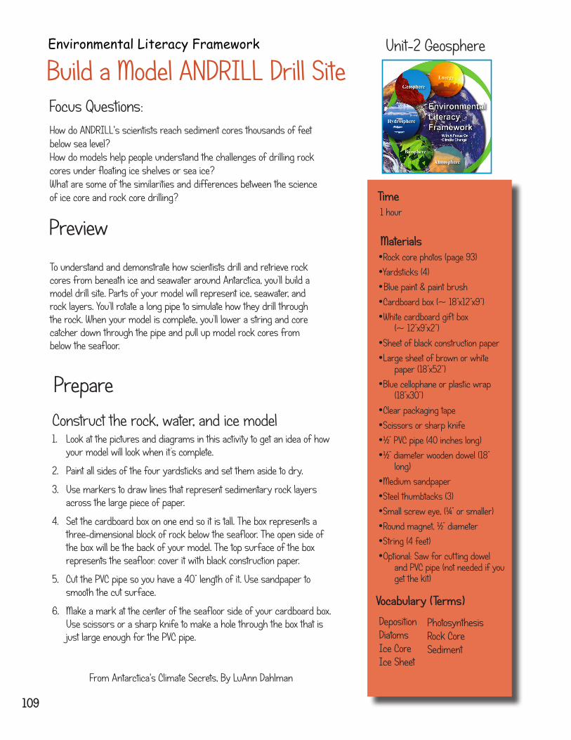
Build a Model ANDRILL Drill SiteEnvironmental Literacy Framework Unit-2 Geosphere
Prepare
Construct the rock, water, and ice model1. Look at the pictures and diagrams in this activity to get an idea of how
your model will look when it’s complete.
2. Paint all sides of the four yardsticks and set them aside to dry.
3. Use markers to draw lines that represent sedimentary rock layers across the large piece of paper.
4. Set the cardboard box on one end so it is tall. The box represents a three-dimensional block of rock below the seafloor. The open side of the box will be the back of your model. The top surface of the box represents the seafloor: cover it with black construction paper.
5. Cut the PVC pipe so you have a 40” length of it. Use sandpaper to smooth the cut surface.
6. Make a mark at the center of the seafloor side of your cardboard box. Use scissors or a sharp knife to make a hole through the box that is just large enough for the PVC pipe.
Time 1 hour
Materials •Rock core photos (page 93)•Yardsticks (4)• Blue paint & paint brush •Cardboard box (~ 18”x12”x9”)•White cardboard gift box
(~ 12”x9”x2”)•Sheet of black construction paper•Large sheet of brown or white
paper (18”x52”)•Blue cellophane or plastic wrap
(18”x30”)•Clear packaging tape•Scissors or sharp knife•½” PVC pipe (40 inches long)•½” diameter wooden dowel (18”
long)•Medium sandpaper•Steel thumbtacks (3)•Small screw eye, (¼” or smaller)•Round magnet, ½” diameter•String (4 feet)•Optional: Saw for cutting dowel
and PVC pipe (not needed if you get the kit)
Focus Questions:
109
From Antarctica's Climate Secrets, By LuAnn Dahlman
To understand and demonstrate how scientists drill and retrieve rock cores from beneath ice and seawater around Antarctica, you’ll build a model drill site. Parts of your model will represent ice, seawater, and rock layers. You’ll rotate a long pipe to simulate how they drill through the rock. When your model is complete, you’ll lower a string and core catcher down through the pipe and pull up model rock cores from below the seafloor.
Preview
How do ANDRILL's scientists reach sediment cores thousands of feetbelow sea level?How do models help people understand the challenges of drilling rockcores under floating ice shelves or sea ice?What are some of the similarities and differences between the scienceof ice core and rock core drilling?
PhotosynthesisRock CoreSediment
DepositionDiatomsIce CoreIce Sheet
Vocabulary (Terms)
Activity 2B- Build a Model ANDRILL Drill Site
Unit-2 Geosphere
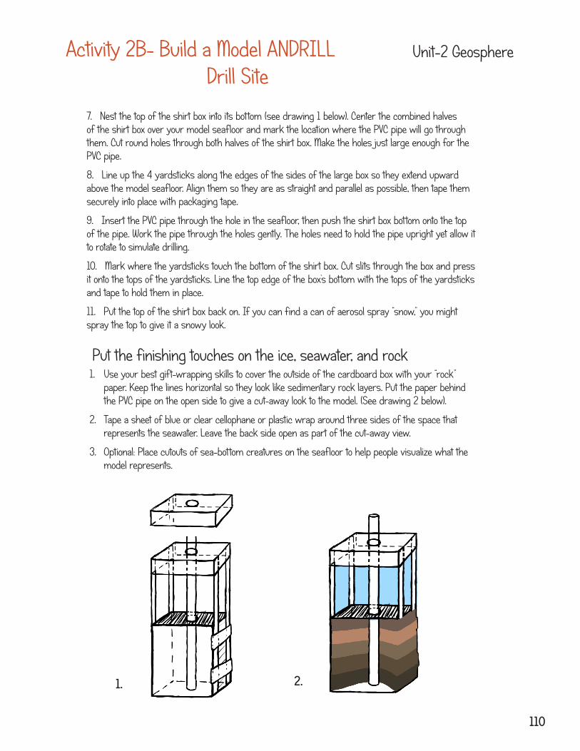
7. Nest the top of the shirt box into its bottom (see drawing 1 below). Center the combined halves of the shirt box over your model seafloor and mark the location where the PVC pipe will go through them. Cut round holes through both halves of the shirt box. Make the holes just large enough for the PVC pipe.
8. Line up the 4 yardsticks along the edges of the sides of the large box so they extend upward above the model seafloor. Align them so they are as straight and parallel as possible, then tape them securely into place with packaging tape.
9. Insert the PVC pipe through the hole in the seafloor, then push the shirt box bottom onto the top of the pipe. Work the pipe through the holes gently. The holes need to hold the pipe upright yet allow it to rotate to simulate drilling.
10. Mark where the yardsticks touch the bottom of the shirt box. Cut slits through the box and press it onto the tops of the yardsticks. Line the top edge of the box’s bottom with the tops of the yardsticks and tape to hold them in place.
11. Put the top of the shirt box back on. If you can find a can of aerosol spray “snow,” you might spray the top to give it a snowy look.
Put the finishing touches on the ice, seawater, and rock1. Use your best gift-wrapping skills to cover the outside of the cardboard box with your “rock”
paper. Keep the lines horizontal so they look like sedimentary rock layers. Put the paper behind the PVC pipe on the open side to give a cut-away look to the model. (See drawing 2 below).
2. Tape a sheet of blue or clear cellophane or plastic wrap around three sides of the space that represents the seawater. Leave the back side open as part of the cut-away view.
3. Optional: Place cutouts of sea-bottom creatures on the seafloor to help people visualize what the model represents.
1. 2.
110
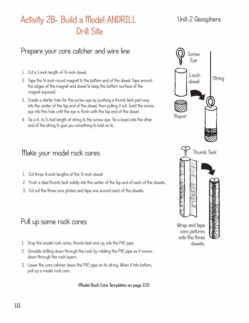
Prepare your core catcher and wire line
1. Cut a 1-inch length of ½-inch dowel.
2. Tape the ½-inch round magnet to the bottom end of the dowel. Tape around the edges of the magnet and dowel to keep the bottom surface of the magnet exposed.
3. Create a starter hole for the screw eye by pushing a thumb tack part way into the center of the top end of the dowel, then pulling it out. Twist the screw eye into this hole until the eye is flush with the top end of the dowel.
4. Tie a 4- to 5-foot length of string to the screw eye. Tie a bead onto the other end of the string to give you something to hold on to.
Activity 2B- Build a Model ANDRILL Drill Site
Unit-2 Geosphere
Thumb Tack
Wrap and tape core pictures
onto the three dowels.
Screw Eye
1-inch dowel
Magnet
String
Make your model rock cores
1. Cut three 4-inch lengths of the ½-inch dowel.
2. Push a steel thumb tack solidly into the center of the top end of each of the dowels.
3. Cut out the three core photos and tape one around each of the dowels.
Pull up some rock cores
1. Drop the model rock cores, thumb tack end up, into the PVC pipe.
2. Simulate drilling down through the rock by rotating the PVC pipe as it moves down through the rock layers.
3. Lower the core catcher down the PVC pipe on its string. When it hits bottom, pull up a model rock core.
(Model Rock Core Templates on page 113)
111
Activity 2B- Build a Model ANDRILL Drill Site
Unit-2 Geosphere
Practice
Got the BIG Idea?
Building, using, or viewing a physical model helps people understand the unique challenges of drilling for rock cores through an ice shelf or sea ice in Antarctica.
Getting ready to present
Come up with a short statement or question to invite people to interact with the drill model. Practice explaining what the different parts of the model represent.
You may want to prepare a chart that shows the description and interpretation of the particular model core your visitors pull up.
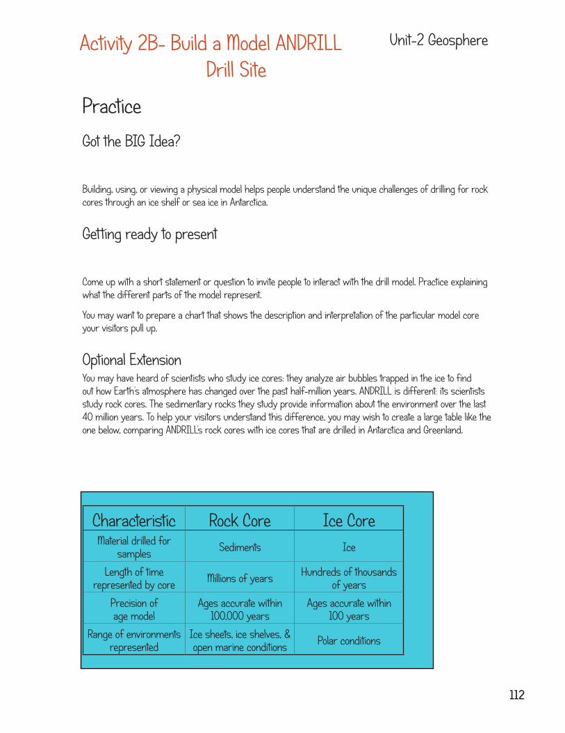
Optional ExtensionYou may have heard of scientists who study ice cores: they analyze air bubbles trapped in the ice to find out how Earth’s atmosphere has changed over the past half-million years. ANDRILL is different: its scientists study rock cores. The sedimentary rocks they study provide information about the environment over the last 40 million years. To help your visitors understand this difference, you may wish to create a large table like the one below, comparing ANDRILL’s rock cores with ice cores that are drilled in Antarctica and Greenland.
Characteristic Rock Core Ice CoreMaterial drilled for
samples Sediments Ice
Length of time represented by core Millions of years Hundreds of thousands
of years
Precision of age model
Ages accurate within 100,000 years
Ages accurate within 100 years
Range of environments represented
Ice sheets, ice shelves, & open marine conditions Polar conditions
112
Activity 2B- Build a Model ANDRILL Drill Site
Unit-2 Geosphere
PonderMake a sketch of the model. Label each part with what it represents in the real world.
In what ways is your model realistic? Which parts of the model are not very realistic?
What ideas do you have for improving the model?
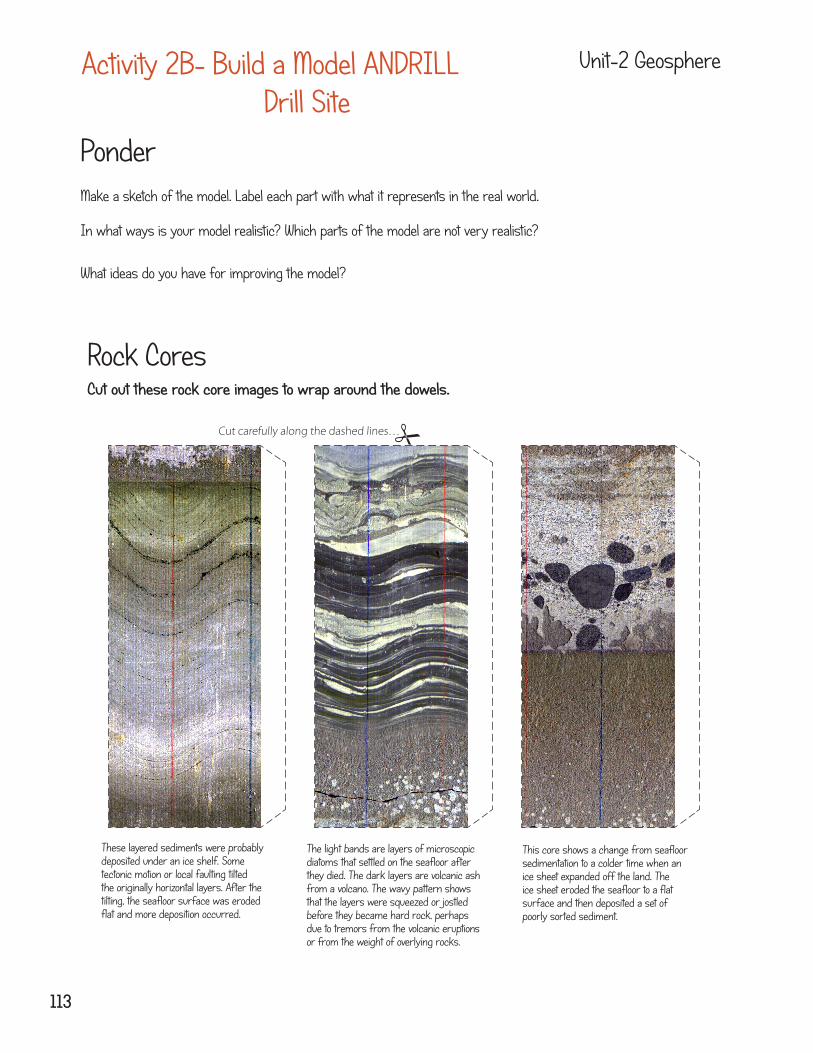
Rock CoresCut out these rock core images to wrap around the dowels.
Cut carefully along the dashed lines…
These layered sediments were probably deposited under an ice shelf. Some tectonic motion or local faulting tilted the originally horizontal layers. After the tilting, the seafloor surface was eroded flat and more deposition occurred.
The light bands are layers of microscopic diatoms that settled on the seafloor after they died. The dark layers are volcanic ash from a volcano. The wavy pattern shows that the layers were squeezed or jostled before they became hard rock, perhaps due to tremors from the volcanic eruptions or from the weight of overlying rocks.
This core shows a change from seafloor sedimentation to a colder time when an ice sheet expanded off the land. The ice sheet eroded the seafloor to a flat surface and then deposited a set of poorly sorted sediment.
113
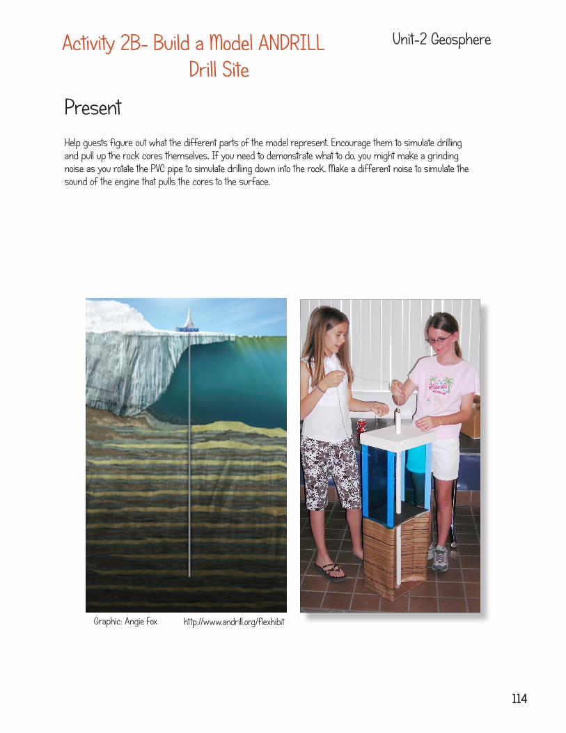
Help guests figure out what the different parts of the model represent. Encourage them to simulate drilling and pull up the rock cores themselves. If you need to demonstrate what to do, you might make a grinding noise as you rotate the PVC pipe to simulate drilling down into the rock. Make a different noise to simulate the sound of the engine that pulls the cores to the surface.
Present
Activity 2B- Build a Model ANDRILL Drill Site
Unit-2 Geosphere
http://www.andrill.org/flexhibitGraphic: Angie Fox
114
Activity 2B- Build a Model ANDRILL Drill Site
Unit-2 Geosphere
115
Background Information for Teachers
About ANDRILL
ANDRILL (ANtarctic geological DRILLing) is a multinational collaboration comprised of more than 200 scientists, students, and educators from five nations (Germany, Italy, New Zealand, the United Kingdom and the United States) to recover stratigraphic records from the Antarctic margin using Cape Roberts Project (CRP) technology. The chief objective is to drill back in time to recover a history of paleoenvironmental changes that will guide our understanding of how fast, how large, and how frequent were glacial and interglacial changes in the Antarctica region. Future scenarios of global warming require guidance and constraint from past history that will reveal potential timing frequency and site of future changes.
Logistical considerations, the extent of existing knowledge of the region, a proven chronological framework, availability of suitable strata for paleoenvironmental and geological study, and majority of initial interest dictated that the McMurdo Sound region be the first area for further Antarctic drilling under the ANDRILL banner. Future target areas around the West Antarctic margin include the Eastern Ross Sea, Weddell Sea and Palmer Basin in West Antarctica, and Terra Nova Bay, Beaver Lake, Prydz Bay and Wilkes Land in East Antarctica. Because of the wide range of proposed drilling targets, individual drilling objectives are grouped into logistically-constrained portfolios. Specific science objectives of the different drill programs include:
•obtain high-resolution sediment cores that record major glacial events and transitional periods over the past 40 million years;•determine orbital and sub-orbital glacio-climatic fluctuations that vary on 100,000, 40,000, and 20,000 year cycles•obtain a refined record of the onset and development of the East Antarctic ice sheet (EAIS) 40 million years ago•identify how the Antarctic region responded to past events of global warmth and test global linkages between climate changes in the Northern and Southern hemispheres
McMurdo Ice Shelf (MIS) Project 2006:
The key aim of the MIS Project was to determine past ice shelf responses to climate forcing, including variability at a range of timescales over the past 40 million years. To achieve this aim ANDRILL drilled sediment core from beneath the McMurdo Ice Shelf. A 1284 m core was recovered through 85 m of ice and 900 m of ocean water.
Southern McMurdo Sound (SMS) Project, 2007:
The key aim of the SMS Project was to establish a robust history of past Antarctic ice sheet variation and climate evolution that can be integrated into continental and global records toward a better understanding of East Antarctica’s role in the past, present, and future global system. To achieve this aim, an 1138 m core was recovered beneath 8 m of sea ice and 383 m of ocean water. A new history of land vegetation and sea-ice cover fed new data into glacial and climate models.
In the future, drilling at Coulman High will investigate: (1) the evolution of the West Antarctic Ice Sheet in a period of high greenhouse gas levels; (2) the Antarctic environment in warm greenhouse periods; (3) controls on Oligocene and Miocene climate and cryosphere; and (4) tectonic processes within the West Antarctic Rift System.
116
Unit Activity Vocabulary Word Definition
Geosphere Build a Model Andrill Drill Site
Deposition The depositing, or laying down of matter by a natural process
Geosphere Build a Model Andrill Drill Site
Diatoms Microscopic, unicellular, marine or freshwater algae of the phylum Chrysophyta, having cell walls containing silica
Geosphere Build a Model Andrill Drill Site
Lithosphere The rigid, outermost shell of Earth
Geosphere Build a Model Andrill Drill Site
Sediments Small naturally occurring materials transported by water wind, or ice which settle into layers
Geosphere Build a Model Andrill Drill Site
Tectonic motion The lithosphere is broken up into tectonic plates. The plates are slowly moving causing oceans to grow and shrink and continents to change positions.
Glossary
Activity 2B- Build a Model ANDRILL Drill Site
Unit-2 Geosphere
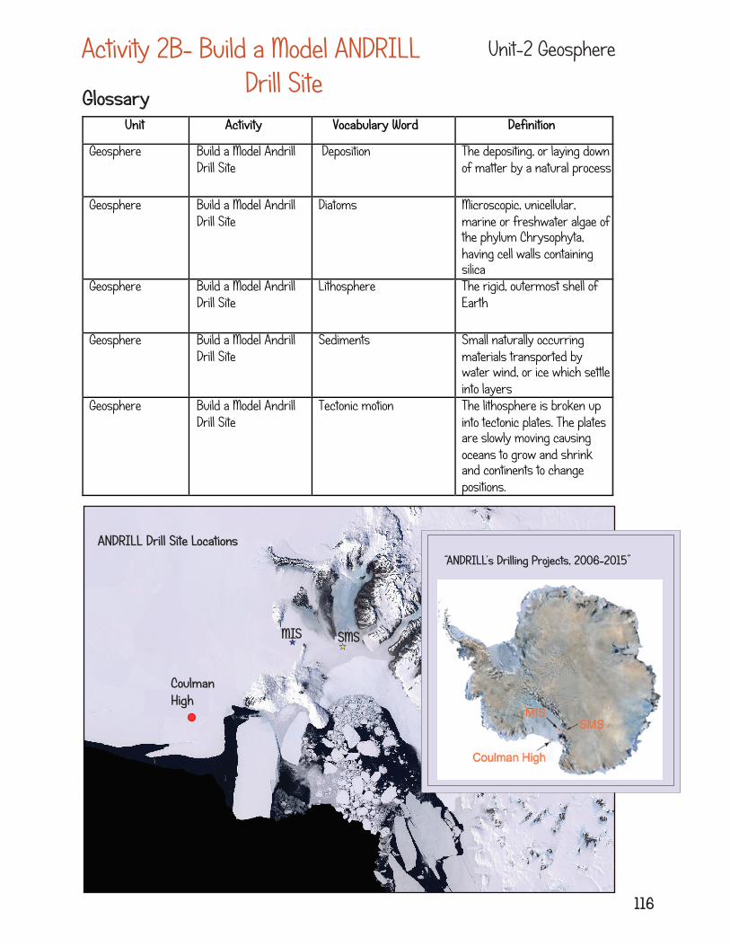
“ANDRILL’s Drilling Projects, 2006-2015”
Coulman High
MIS SMS
ANDRILL Drill Site Locations