Embed Size (px)
Citation preview
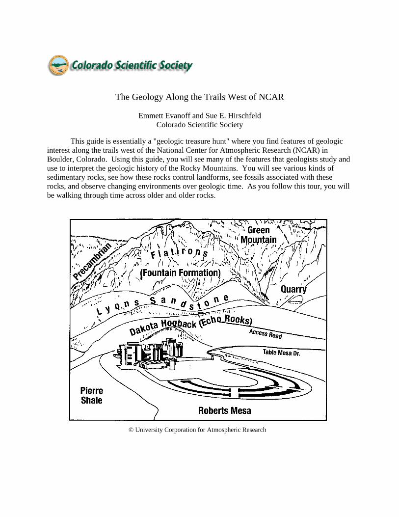
The Geology Along the Trails West of NCAR
Emmett Evanoff and Sue E. Hirschfeld Colorado Scientific Society
This guide is essentially a "geologic treasure hunt" where you find features of geologic interest along the trails west of the National Center for Atmospheric Research (NCAR) in Boulder, Colorado. Using this guide, you will see many of the features that geologists study and use to interpret the geologic history of the Rocky Mountains. You will see various kinds of sedimentary rocks, see how these rocks control landforms, see fossils associated with these rocks, and observe changing environments over geologic time. As you follow this tour, you will be walking through time across older and older rocks.
© University Corporation for Atmospheric Research
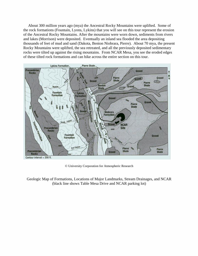
About 300 million years ago (mya) the Ancestral Rocky Mountains were uplifted. Some of the rock formations (Fountain, Lyons, Lykins) that you will see on this tour represent the erosion of the Ancestral Rocky Mountains. After the mountains were worn down, sediments from rivers and lakes (Morrison) were deposited. Eventually an inland sea flooded the area depositing thousands of feet of mud and sand (Dakota, Benton Niobrara, Pierre). About 70 mya, the present Rocky Mountains were uplifted, the sea retreated, and all the previously deposited sedimentary rocks were tilted up against the rising mountains. From NCAR Mesa, you see the eroded edges of these tilted rock formations and can hike across the entire section on this tour.
© University Corporation for Atmospheric Research
Geologic Map of Formations, Locations of Major Landmarks, Stream Drainages, and NCAR
(black line shows Table Mesa Drive and NCAR parking lot)
© University Corporation for Atmospheric Research
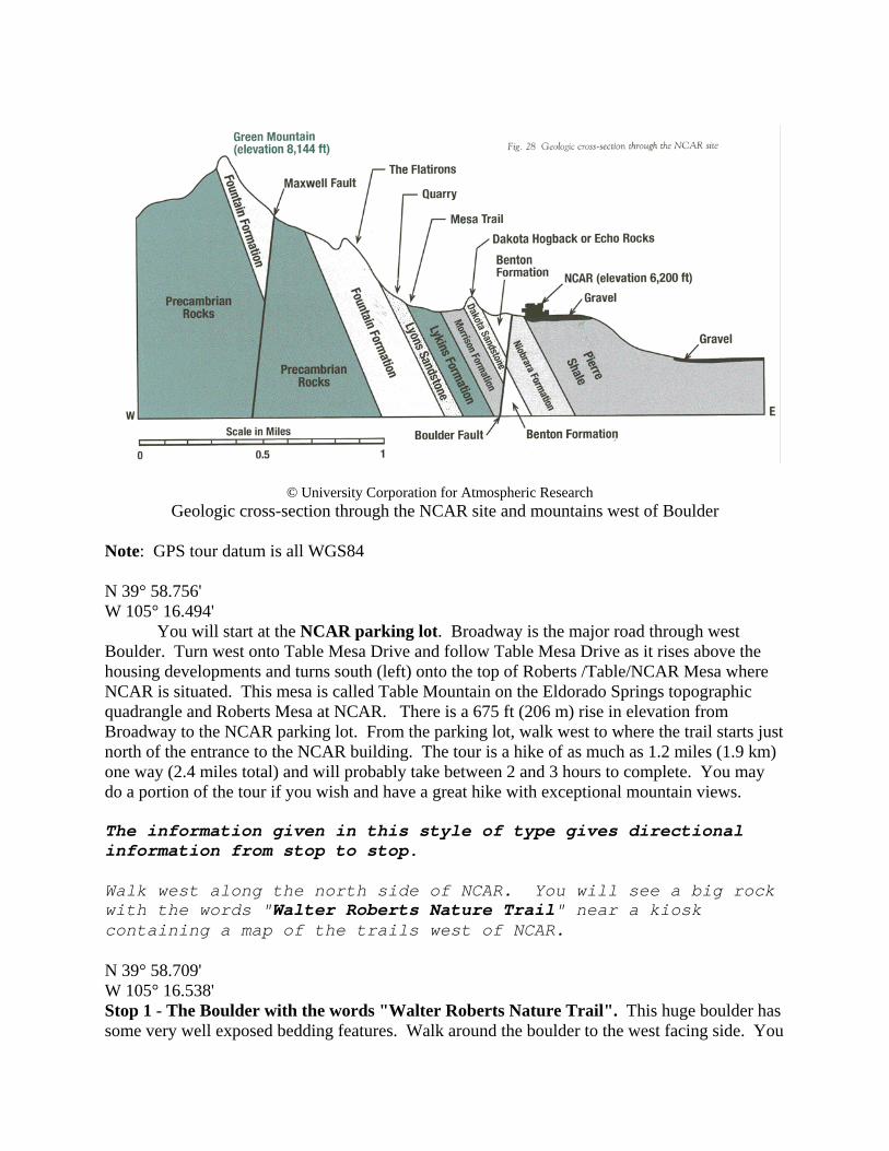
Geologic cross-section through the NCAR site and mountains west of Boulder Note: GPS tour datum is all WGS84 N 39° 58.756' W 105° 16.494' You will start at the NCAR parking lot. Broadway is the major road through west Boulder. Turn west onto Table Mesa Drive and follow Table Mesa Drive as it rises above the housing developments and turns south (left) onto the top of Roberts /Table/NCAR Mesa where NCAR is situated. This mesa is called Table Mountain on the Eldorado Springs topographic quadrangle and Roberts Mesa at NCAR. There is a 675 ft (206 m) rise in elevation from Broadway to the NCAR parking lot. From the parking lot, walk west to where the trail starts just north of the entrance to the NCAR building. The tour is a hike of as much as 1.2 miles (1.9 km) one way (2.4 miles total) and will probably take between 2 and 3 hours to complete. You may do a portion of the tour if you wish and have a great hike with exceptional mountain views. The information given in this style of type gives directional information from stop to stop. Walk west along the north side of NCAR. You will see a big rock with the words "Walter Roberts Nature Trail" near a kiosk containing a map of the trails west of NCAR. N 39° 58.709' W 105° 16.538' Stop 1 - The Boulder with the words "Walter Roberts Nature Trail". This huge boulder has some very well exposed bedding features. Walk around the boulder to the west facing side. You
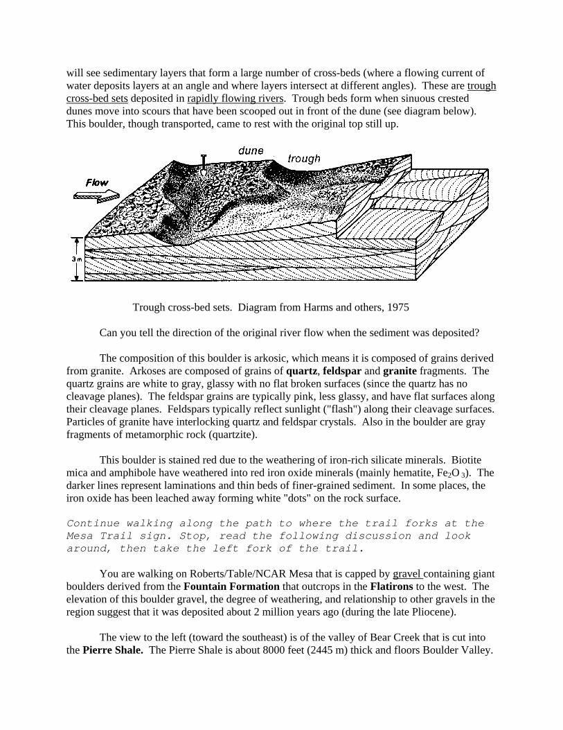
will see sedimentary layers that form a large number of cross-beds (where a flowing current of water deposits layers at an angle and where layers intersect at different angles). These are trough cross-bed sets deposited in rapidly flowing rivers. Trough beds form when sinuous crested dunes move into scours that have been scooped out in front of the dune (see diagram below). This boulder, though transported, came to rest with the original top still up.
Trough cross-bed sets. Diagram from Harms and others, 1975
Can you tell the direction of the original river flow when the sediment was deposited?
The composition of this boulder is arkosic, which means it is composed of grains derived from granite. Arkoses are composed of grains of quartz, feldspar and granite fragments. The quartz grains are white to gray, glassy with no flat broken surfaces (since the quartz has no cleavage planes). The feldspar grains are typically pink, less glassy, and have flat surfaces along their cleavage planes. Feldspars typically reflect sunlight ("flash") along their cleavage surfaces. Particles of granite have interlocking quartz and feldspar crystals. Also in the boulder are gray fragments of metamorphic rock (quartzite). This boulder is stained red due to the weathering of iron-rich silicate minerals. Biotite mica and amphibole have weathered into red iron oxide minerals (mainly hematite, Fe2O 3). The darker lines represent laminations and thin beds of finer-grained sediment. In some places, the iron oxide has been leached away forming white "dots" on the rock surface. Continue walking along the path to where the trail forks at the Mesa Trail sign. Stop, read the following discussion and look around, then take the left fork of the trail. You are walking on Roberts/Table/NCAR Mesa that is capped by gravel containing giant boulders derived from the Fountain Formation that outcrops in the Flatirons to the west. The elevation of this boulder gravel, the degree of weathering, and relationship to other gravels in the region suggest that it was deposited about 2 million years ago (during the late Pliocene).
The view to the left (toward the southeast) is of the valley of Bear Creek that is cut into the Pierre Shale. The Pierre Shale is about 8000 feet (2445 m) thick and floors Boulder Valley.
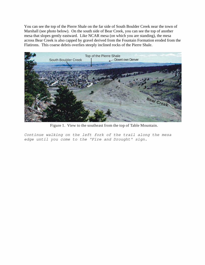
You can see the top of the Pierre Shale on the far side of South Boulder Creek near the town of Marshall (see photo below). On the south side of Bear Creek, you can see the top of another mesa that slopes gently eastward. Like NCAR mesa (on which you are standing), the mesa across Bear Creek is also capped by gravel derived from the Fountain Formation eroded from the Flatirons. This coarse debris overlies steeply inclined rocks of the Pierre Shale.
Bear Creek
South Boulder CreekTop of the Pierre Shale
Downt own Denver
Figure 1. View to the southeast from the top of Table Mountain. Continue walking on the left fork of the trail along the mesa edge until you come to the "Fire and Drought" sign.
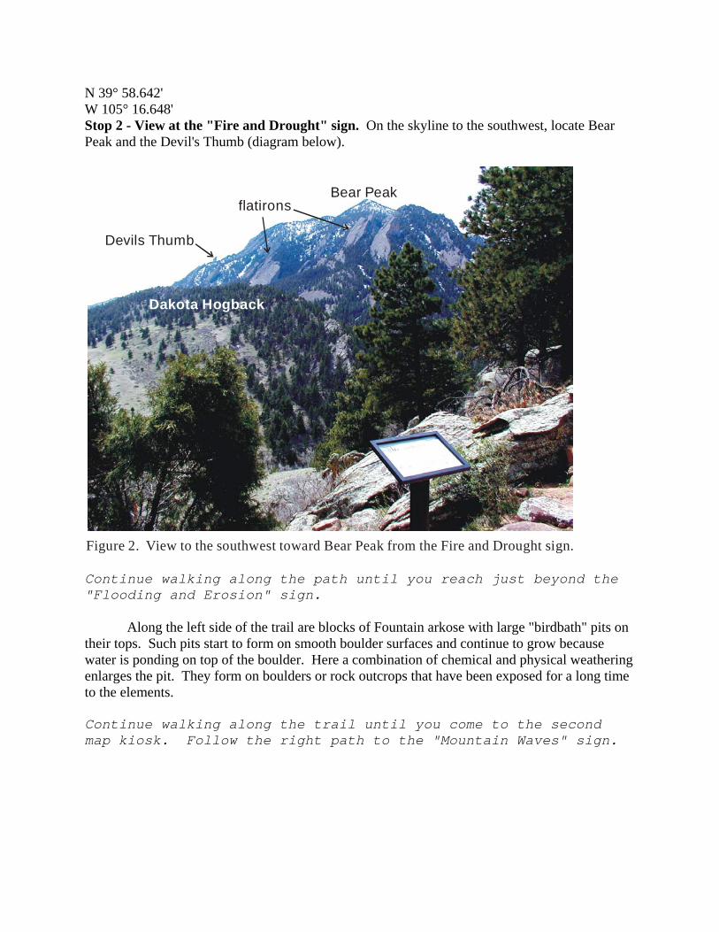
N 39° 58.642' W 105° 16.648' Stop 2 - View at the "Fire and Drought" sign. On the skyline to the southwest, locate Bear Peak and the Devil's Thumb (diagram below).
Bear Peak
Devils Thumb
flatirons
Figure 2. View to the southwest toward Bear Peak from the Fire and Drought sign.
Dakota Hogback
Continue walking along the path until you reach just beyond the "Flooding and Erosion" sign. Along the left side of the trail are blocks of Fountain arkose with large "birdbath" pits on their tops. Such pits start to form on smooth boulder surfaces and continue to grow because water is ponding on top of the boulder. Here a combination of chemical and physical weathering enlarges the pit. They form on boulders or rock outcrops that have been exposed for a long time to the elements. Continue walking along the trail until you come to the second map kiosk. Follow the right path to the "Mountain Waves" sign.
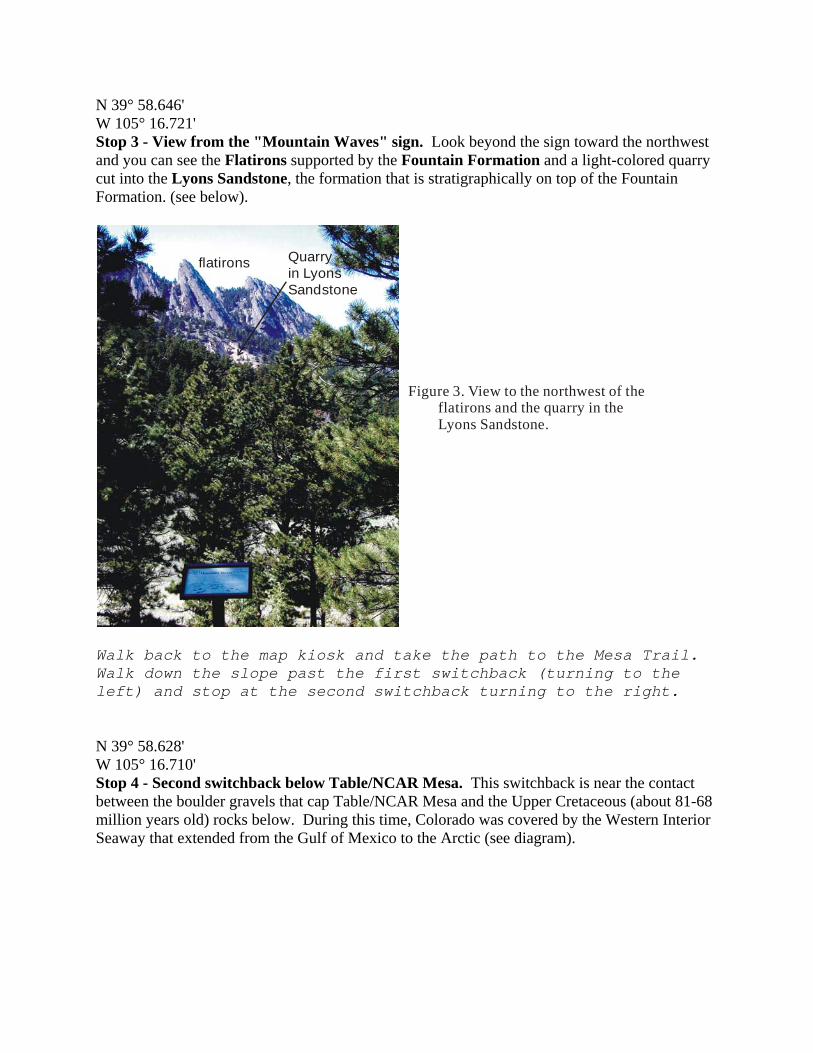
N 39° 58.646' W 105° 16.721' Stop 3 - View from the "Mountain Waves" sign. Look beyond the sign toward the northwest and you can see the Flatirons supported by the Fountain Formation and a light-colored quarry cut into the Lyons Sandstone, the formation that is stratigraphically on top of the Fountain Formation. (see below).
flatirons Quarry in LyonsSandstone
Figure 3. View to the northwest of the flatirons and the quarry in the Lyons Sandstone.
Walk back to the map kiosk and take the path to the Mesa Trail. Walk down the slope past the first switchback (turning to the left) and stop at the second switchback turning to the right. N 39° 58.628' W 105° 16.710' Stop 4 - Second switchback below Table/NCAR Mesa. This switchback is near the contact between the boulder gravels that cap Table/NCAR Mesa and the Upper Cretaceous (about 81-68 million years old) rocks below. During this time, Colorado was covered by the Western Interior Seaway that extended from the Gulf of Mexico to the Arctic (see diagram).
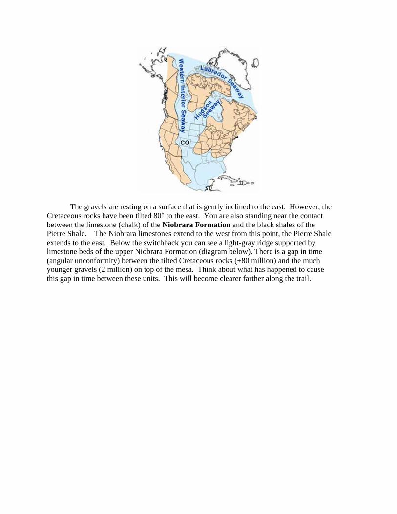
The gravels are resting on a surface that is gently inclined to the east. However, the Cretaceous rocks have been tilted 80° to the east. You are also standing near the contact between the limestone (chalk) of the Niobrara Formation and the black shales of the Pierre Shale. The Niobrara limestones extend to the west from this point, the Pierre Shale extends to the east. Below the switchback you can see a light-gray ridge supported by limestone beds of the upper Niobrara Formation (diagram below). There is a gap in time (angular unconformity) between the tilted Cretaceous rocks (+80 million) and the much younger gravels (2 million) on top of the mesa. Think about what has happened to cause this gap in time between these units. This will become clearer farther along the trail.
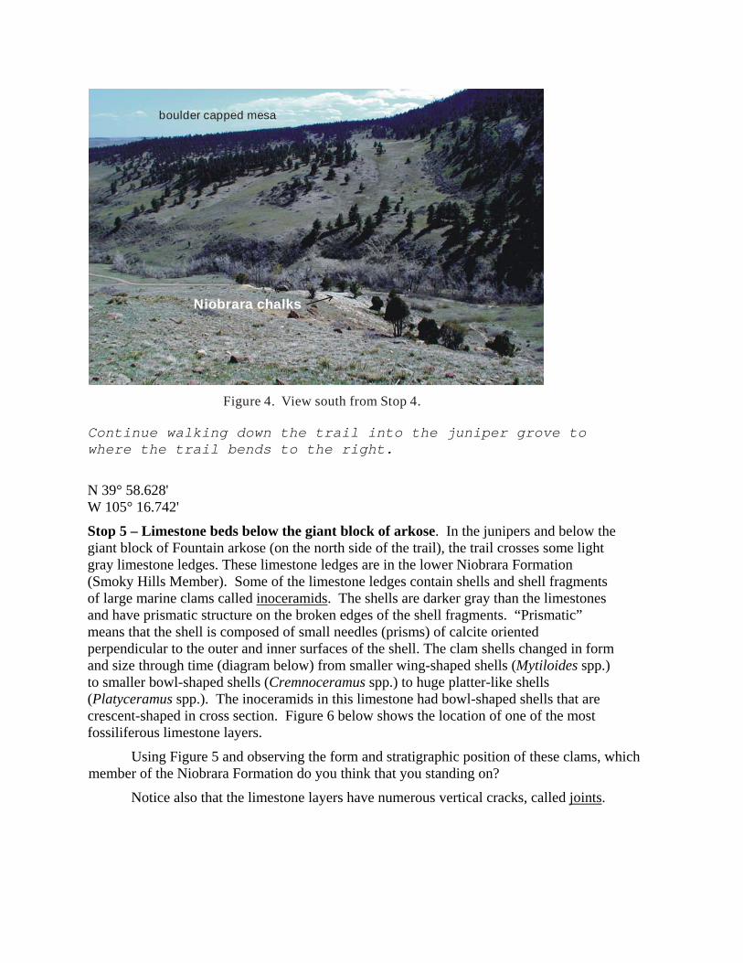
boulder capped mesa
Niobrara chalks
Figure 4. View south from Stop 4.
Continue walking down the trail into the juniper grove to where the trail bends to the right.
N 39° 58.628' W 105° 16.742'
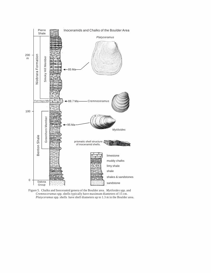
Stop 5 – Limestone beds below the giant block of arkose. In the junipers and below the giant block of Fountain arkose (on the north side of the trail), the trail crosses some light gray limestone ledges. These limestone ledges are in the lower Niobrara Formation (Smoky Hills Member). Some of the limestone ledges contain shells and shell fragments of large marine clams called inoceramids. The shells are darker gray than the limestones and have prismatic structure on the broken edges of the shell fragments. “Prismatic” means that the shell is composed of small needles (prisms) of calcite oriented perpendicular to the outer and inner surfaces of the shell. The clam shells changed in form and size through time (diagram below) from smaller wing-shaped shells (Mytiloides spp.) to smaller bowl-shaped shells (Cremnoceramus spp.) to huge platter-like shells (Platyceramus spp.). The inoceramids in this limestone had bowl-shaped shells that are crescent-shaped in cross section. Figure 6 below shows the location of one of the most fossiliferous limestone layers.
Using Figure 5 and observing the form and stratigraphic position of these clams, which member of the Niobrara Formation do you think that you standing on?
Notice also that the limestone layers have numerous vertical cracks, called joints.
Platyceramus
Cremnoceramus
Mytiloides
limestone
muddy chalks
limy shale
shale
shales & sandstones
sandstone
Fort Hays Mbr
Sm
oky
Hill
Mem
ber
Nio
brar
a Fo
rmat
ion
Ben
ton
Sha
le
Gre
enho
rn M
embe
r
DakotaGroup
95 Ma
88.7 Ma
85 Ma
PierreShale
0
100
200m
Inoceramids and Chalks of the Boulder Area
prismatic shell structureof inoceramid shells.
Figure 5. Chalks and Inoceramid genera of the Boulder area. spp. and spp. shells typically have maximum diameters of 15 cm.
shells have shell diameters up to 1.3 m in the Boulder area.
Mytiloides Cremnoceramus
Platyceramus spp.
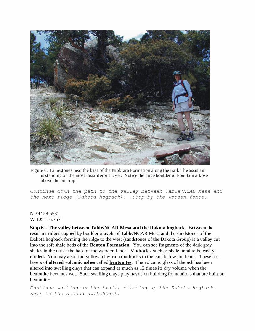
Figure 6. Limestones near the base of the Niobrara Formation along the trail. The assistant is standing on the most fossiliferous layer. Notice the huge boulder of Fountain arkose above the outcrop.
Continue down the path to the valley between Table/NCAR Mesa and the next ridge (Dakota hogback). Stop by the wooden fence.
N 39° 58.653' W 105° 16.757'
Stop 6 – The valley between Table/NCAR Mesa and the Dakota hogback. Between the resistant ridges capped by boulder gravels of Table/NCAR Mesa and the sandstones of the Dakota hogback forming the ridge to the west (sandstones of the Dakota Group) is a valley cut into the soft shale beds of the Benton Formation. You can see fragments of the dark gray shales in the cut at the base of the wooden fence. Mudrocks, such as shale, tend to be easily eroded. You may also find yellow, clay-rich mudrocks in the cuts below the fence. These are layers of altered volcanic ashes called bentonites. The volcanic glass of the ash has been altered into swelling clays that can expand as much as 12 times its dry volume when the bentonite becomes wet. Such swelling clays play havoc on building foundations that are built on bentonites. Continue walking on the trail, climbing up the Dakota hogback. Walk to the second switchback.
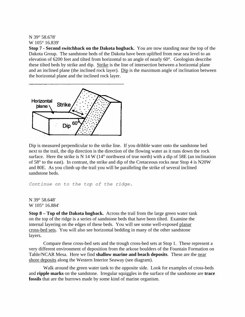
N 39° 58.678' W 105° 16.839' Stop 7 - Second switchback on the Dakota hogback. You are now standing near the top of the Dakota Group. The sandstone beds of the Dakota have been uplifted from near sea level to an elevation of 6200 feet and tilted from horizontal to an angle of nearly 60°. Geologists describe these tilted beds by strike and dip. Strike is the line of intersection between a horizontal plane and an inclined plane (the inclined rock layer). Dip is the maximum angle of inclination between the horizontal plane and the inclined rock layer.
Dip is measured perpendicular to the strike line. If you dribble water onto the sandstone bed next to the trail, the dip direction is the direction of the flowing water as it runs down the rock surface. Here the strike is N 14 W (14° northwest of true north) with a dip of 58E (an inclination of 58° to the east). In contrast, the strike and dip of the Cretaceous rocks near Stop 4 is N20W and 80E. As you climb up the trail you will be paralleling the strike of several inclined sandstone beds. Continue on to the top of the ridge.
N 39° 58.648' W 105° 16.884'
Stop 8 – Top of the Dakota hogback. Across the trail from the large green water tank on the top of the ridge is a series of sandstone beds that have been tilted. Examine the internal layering on the edges of these beds. You will see some well-exposed planar cross-bed sets. You will also see horizontal bedding in many of the other sandstone layers.
Compare these cross-bed sets and the trough cross-bed sets at Stop 1. These represent a very different environment of deposition from the arkose boulders of the Fountain Formation on Table/NCAR Mesa. Here we find shallow marine and beach deposits. These are the near shore deposits along the Western Interior Seaway (see diagram).
Walk around the green water tank to the opposite side. Look for examples of cross-beds and ripple marks on the sandstone. Irregular squiggles in the surface of the sandstone are trace fossils that are the burrows made by some kind of marine organism.
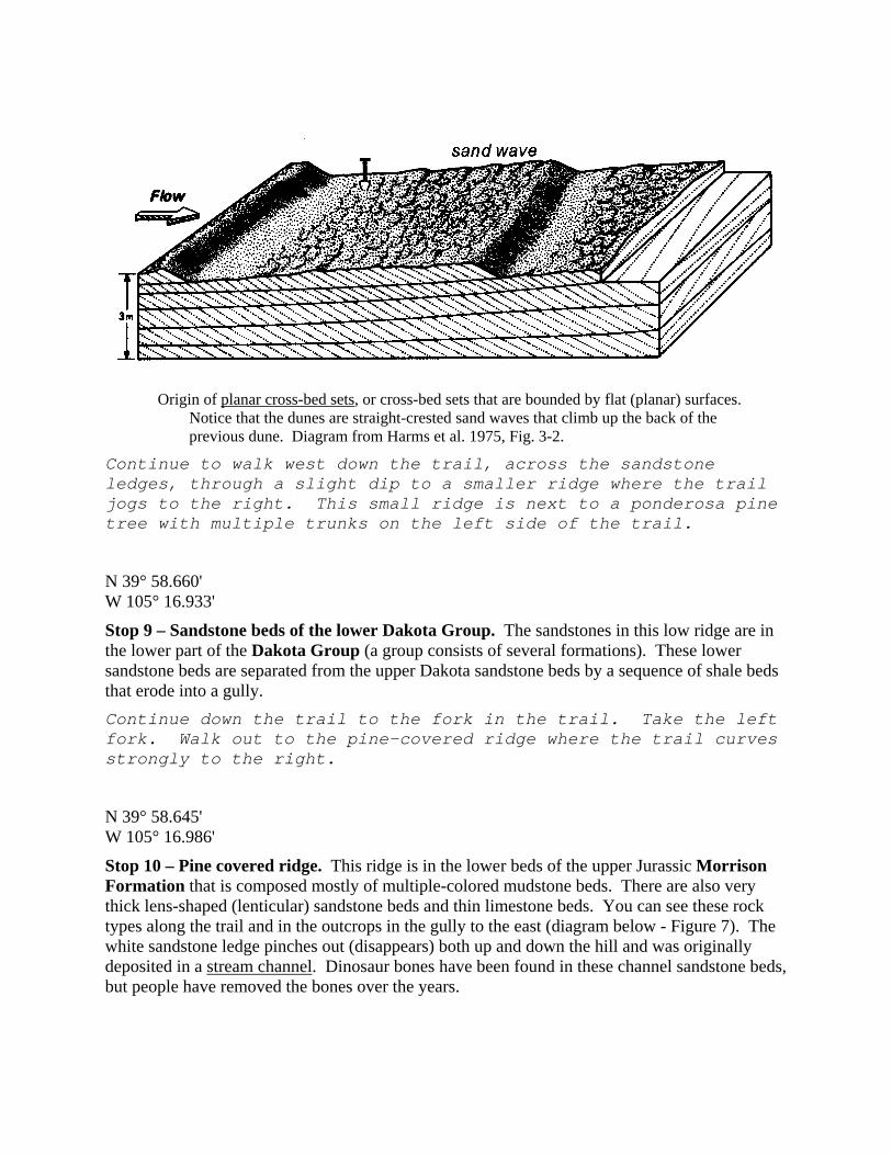
Origin of planar cross-bed sets, or cross-bed sets that are bounded by flat (planar) surfaces.
Notice that the dunes are straight-crested sand waves that climb up the back of the previous dune. Diagram from Harms et al. 1975, Fig. 3-2.
Continue to walk west down the trail, across the sandstone ledges, through a slight dip to a smaller ridge where the trail jogs to the right. This small ridge is next to a ponderosa pine tree with multiple trunks on the left side of the trail.
N 39° 58.660' W 105° 16.933'
Stop 9 – Sandstone beds of the lower Dakota Group. The sandstones in this low ridge are in the lower part of the Dakota Group (a group consists of several formations). These lower sandstone beds are separated from the upper Dakota sandstone beds by a sequence of shale beds that erode into a gully. Continue down the trail to the fork in the trail. Take the left fork. Walk out to the pine-covered ridge where the trail curves strongly to the right.
N 39° 58.645' W 105° 16.986'
Stop 10 – Pine covered ridge. This ridge is in the lower beds of the upper Jurassic Morrison Formation that is composed mostly of multiple-colored mudstone beds. There are also very thick lens-shaped (lenticular) sandstone beds and thin limestone beds. You can see these rock types along the trail and in the outcrops in the gully to the east (diagram below - Figure 7). The white sandstone ledge pinches out (disappears) both up and down the hill and was originally deposited in a stream channel. Dinosaur bones have been found in these channel sandstone beds, but people have removed the bones over the years.
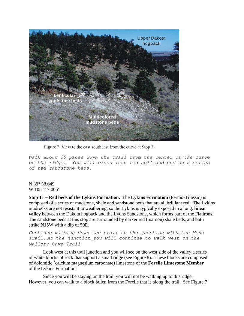
Lenticular sandstone beds
Multicoloredmudstone beds
Upper Dakotahogback
Figure 7. View to the east southeast from the curve at Stop 7.
Walk about 30 paces down the trail from the center of the curve on the ridge. You will cross into red soil and end on a series of red sandstone beds.
N 39° 58.649' W 105° 17.005'
Stop 11 – Red beds of the Lykins Formation. The Lykins Formation (Permo-Triassic) is composed of a series of mudstone, shale and sandstone beds that are all brilliant red. The Lykins mudrocks are not resistant to weathering, so the Lykins is typically exposed in a long, linear valley between the Dakota hogback and the Lyons Sandstone, which forms part of the Flatirons. The sandstone beds at this stop are surrounded by darker red (maroon) shale beds, and both strike N15W with a dip of 59E. Continue walking down the trail to the junction with the Mesa Trail. At the junction you will continue to walk west on the Mallory Cave Trail.
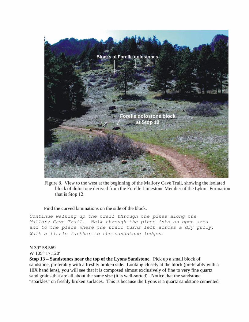
Look west at this trail junction and you will see on the west side of the valley a series of white blocks of rock that support a small ridge (see Figure 8). These blocks are composed of dolomitic (calcium magnesium carbonate) limestone of the Forelle Limestone Member of the Lykins Formation.
Since you will be staying on the trail, you will not be walking up to this ridge. However, you can walk to a block fallen from the Forelle that is along the trail. See Figure 7
to see where this block is located, and walk to this block. Be careful of the poison ivy that grows near the block and along the trail.
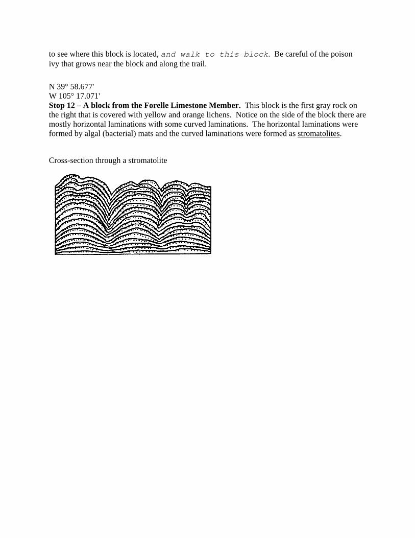
N 39° 58.677' W 105° 17.071' Stop 12 – A block from the Forelle Limestone Member. This block is the first gray rock on the right that is covered with yellow and orange lichens. Notice on the side of the block there are mostly horizontal laminations with some curved laminations. The horizontal laminations were formed by algal (bacterial) mats and the curved laminations were formed as stromatolites.
Cross-section through a stromatolite
Blocks of Forelle dolostones
Forelle dolostone block at Stop 12
Figure 8. View to the west at the beginning of the Mallory Cave Trail, showing the isolated block of dolostone derived from the Forelle Limestone Member of the Lykins Formation that is Stop 12.
Find the curved laminations on the side of the block. Continue walking up the trail through the pines along the Mallory Cave Trail. Walk through the pines into an open area and to the place where the trail turns left across a dry gully. Walk a little farther to the sandstone ledges.
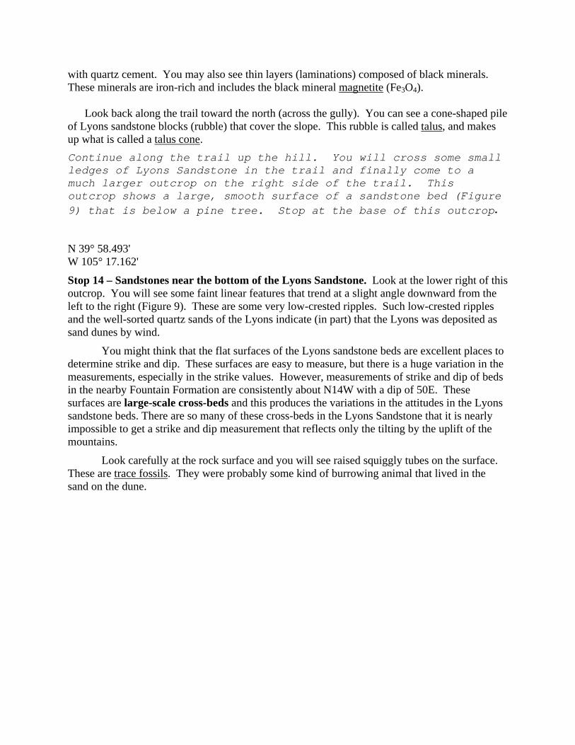
N 39° 58.569' W 105° 17.120' Stop 13 – Sandstones near the top of the Lyons Sandstone. Pick up a small block of sandstone, preferably with a freshly broken side. Looking closely at the block (preferably with a 10X hand lens), you will see that it is composed almost exclusively of fine to very fine quartz sand grains that are all about the same size (it is well-sorted). Notice that the sandstone “sparkles” on freshly broken surfaces. This is because the Lyons is a quartz sandstone cemented
with quartz cement. You may also see thin layers (laminations) composed of black minerals. These minerals are iron-rich and includes the black mineral magnetite (Fe3O4).
Look back along the trail toward the north (across the gully). You can see a cone-shaped pile of Lyons sandstone blocks (rubble) that cover the slope. This rubble is called talus, and makes up what is called a talus cone. Continue along the trail up the hill. You will cross some small ledges of Lyons Sandstone in the trail and finally come to a much larger outcrop on the right side of the trail. This outcrop shows a large, smooth surface of a sandstone bed (Figure 9) that is below a pine tree. Stop at the base of this outcrop.
N 39° 58.493' W 105° 17.162'
Stop 14 – Sandstones near the bottom of the Lyons Sandstone. Look at the lower right of this outcrop. You will see some faint linear features that trend at a slight angle downward from the left to the right (Figure 9). These are some very low-crested ripples. Such low-crested ripples and the well-sorted quartz sands of the Lyons indicate (in part) that the Lyons was deposited as sand dunes by wind.
You might think that the flat surfaces of the Lyons sandstone beds are excellent places to determine strike and dip. These surfaces are easy to measure, but there is a huge variation in the measurements, especially in the strike values. However, measurements of strike and dip of beds in the nearby Fountain Formation are consistently about N14W with a dip of 50E. These surfaces are large-scale cross-beds and this produces the variations in the attitudes in the Lyons sandstone beds. There are so many of these cross-beds in the Lyons Sandstone that it is nearly impossible to get a strike and dip measurement that reflects only the tilting by the uplift of the mountains.
Look carefully at the rock surface and you will see raised squiggly tubes on the surface. These are trace fossils. They were probably some kind of burrowing animal that lived in the sand on the dune.
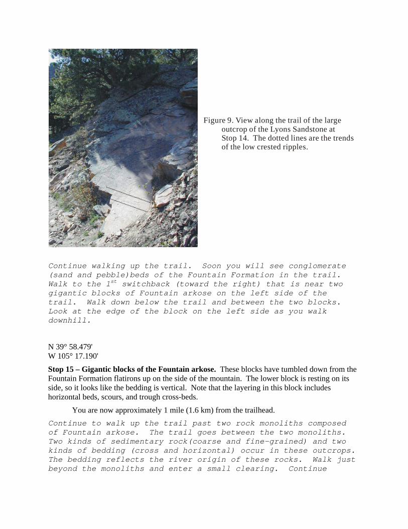
Figure 9. View along the trail of the large outcrop of the Lyons Sandstone at Stop 14. The dotted lines are the trends
of the low crested ripples.
Continue walking up the trail. Soon you will see conglomerate (sand and pebble)beds of the Fountain Formation in the trail. Walk to the 1st switchback (toward the right) that is near two gigantic blocks of Fountain arkose on the left side of the trail. Walk down below the trail and between the two blocks. Look at the edge of the block on the left side as you walk downhill.
N 39° 58.479' W 105° 17.190'
Stop 15 – Gigantic blocks of the Fountain arkose. These blocks have tumbled down from the Fountain Formation flatirons up on the side of the mountain. The lower block is resting on its side, so it looks like the bedding is vertical. Note that the layering in this block includes horizontal beds, scours, and trough cross-beds.
You are now approximately 1 mile (1.6 km) from the trailhead. Continue to walk up the trail past two rock monoliths composed of Fountain arkose. The trail goes between the two monoliths. Two kinds of sedimentary rock(coarse and fine-grained) and two kinds of bedding (cross and horizontal) occur in these outcrops. The bedding reflects the river origin of these rocks. Walk just beyond the monoliths and enter a small clearing. Continue
walking up the trail until you reach a post showing the entrance to the Dinosaur Rock Climbing Area at the sharp turn to the right of the Mallory Cave Trail.
N 39° 58.421' W 105° 17.226'
Stop 16 – Base of the Flatirons -- Dinosaur Rock. The flatirons here are Permian, (about 300 million years old) Fountain Formation. The rocks in this flatiron are all arkosic, and include beds of conglomerates and maroon sandstones. They were formed in rivers draining the Ancestral Rocky Mountains. These rocks strike at N14W and dip 50E and they were tilted during the uplift of the present Rocky Mountains about 64 million years ago.
This is the last stop of the tour. You can return back to the NCAR trailhead, 1.2 mi (1.9 km) away, or you can take the right fork up toward Mallory Cave. Not far beyond this post, the trail becomes very steep with many switchbacks and is somewhat hard to distinguish in some places. The final climb to the cave (that requires some simple rock climbing) is closed between April 1 and October 1 because the cave is a nesting site for bats. However, there are some spectacular views of Boulder Valley from the trail. You can also continue along the Mesa Trail to the south. Bear Canyon Trail will take you up along Bear Creek between the Flatirons to the contact with the 1.7 billion year old Boulder Creek Granite.
References Cited: Harms, J.C., Southard, J.B., Spearing, D.R., and Walker, R.G., 1975, Depositional environments as interpreted from primary sedimentary structures and stratification sequences: SEPM Short Course no. 2, 161 p. Multiple authors in Natural Features of NCAR’s Mesa Site