Embed Size (px)
Citation preview
The impacts on groundwaterdevelopment on shallow aquifersin the lower Okavango Delta,northwestern BotswanaF. Linn Æ M. Masie Æ A. Rana
Abstract The Okavango Delta is a large alluvial fancomplex in the northwest corner of Botswana. Bothsurface and groundwater in this area are importantto wildlife, flora, and human settlements. Agroundwater exploration study covering an area ofover 14,000 km2 was undertaken to assess thepotential of groundwater to supply a major town andassociated settlements. The primary control ongroundwater development potential is water quality,with much of the area characterised by brackish/saline aquifers. This largely reflects the high rate ofpotential evapotranspiration. As a consequence,freshwater aquifers are strongly dependent onrecharge from surface water during annual flooding.In the absence of river flow, water quality in thefresh aquifers begins to deteriorate and the thicknessof the fresh water lens reduces through upwardmigration from underlying saline aquifers. Lateralinflow from surrounding saline aquifers does notappear to be a significant. The impacts of evapo-transpiration indicate the importance of regularsurface water recharge to sustainable developmentof groundwater resources. Groundwater develop-ment strategies are changing as a result of theunderstanding of salinification processes in theseaquifers.
Keywords Botswana Æ Groundwater developmentGroundwater salinification Æ Okavango Delta
Introduction
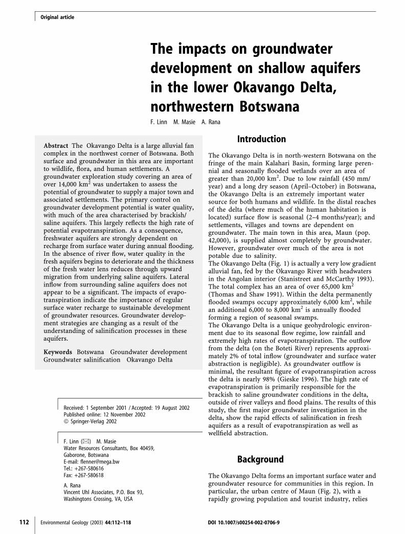
The Okavango Delta is in north-western Botswana on thefringe of the main Kalahari Basin, forming large peren-nial and seasonally flooded wetlands over an area ofgreater than 20,000 km2. Due to low rainfall (450 mm/year) and a long dry season (April–October) in Botswana,the Okavango Delta is an extremely important watersource for both humans and wildlife. In the distal reachesof the delta (where much of the human habitation islocated) surface flow is seasonal (2–4 months/year); andsettlements, villages and towns are dependent ongroundwater. The main town in this area, Maun (pop.42,000), is supplied almost completely by groundwater.However, groundwater over much of the area is notpotable due to salinity.The Okavango Delta (Fig. 1) is actually a very low gradientalluvial fan, fed by the Okavango River with headwatersin the Angolan interior (Stanistreet and McCarthy 1993).The total complex has an area of over 65,000 km2
(Thomas and Shaw 1991). Within the delta permanentlyflooded swamps occupy approximately 6,000 km2, whilean additional 6,000 to 8,000 km2 is annually floodedforming a region of seasonal swamps.The Okavango Delta is a unique geohydrologic environ-ment due to its seasonal flow regime, low rainfall andextremely high rates of evapotranspiration. The outflowfrom the delta (on the Boteti River) represents approxi-mately 2% of total inflow (groundwater and surface waterabstraction is negligible). As groundwater outflow isminimal, the resultant figure of evapotranspiration acrossthe delta is nearly 98% (Gieske 1996). The high rate ofevapotranspiration is primarily responsible for thebrackish to saline groundwater conditions in the delta,outside of river valleys and flood plains. The results of thisstudy, the first major groundwater investigation in thedelta, show the rapid effects of salinification in freshaquifers as a result of evapotranspiration as well aswellfield abstraction.
Background
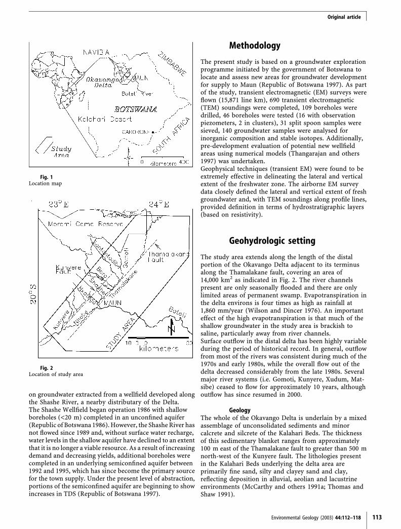
The Okavango Delta forms an important surface water andgroundwater resource for communities in this region. Inparticular, the urban centre of Maun (Fig. 2), with arapidly growing population and tourist industry, relies
Received: 1 September 2001 / Accepted: 19 August 2002Published online: 12 November 2002ª Springer-Verlag 2002
F. Linn (&) Æ M. MasieWater Resources Consultants, Box 40459,Gaborone, BotswanaE-mail: [email protected].: +267-580616Fax: +267-580618
A. RanaVincent Uhl Associates, P.O. Box 93,Washingtons Crossing, VA, USA
Original article
112 Environmental Geology (2003) 44:112–118 DOI 10.1007/s00254-002-0706-9
on groundwater extracted from a wellfield developed alongthe Shashe River, a nearby distributary of the Delta.The Shashe Wellfield began operation 1986 with shallowboreholes (<20 m) completed in an unconfined aquifer(Republic of Botswana 1986). However, the Shashe River hasnot flowed since 1989 and, without surface water recharge,water levels in the shallow aquifer have declined to an extentthat it is no longer a viable resource. As a result of increasingdemand and decreasing yields, additional boreholes werecompleted in an underlying semiconfined aquifer between1992 and 1995, which has since become the primary sourcefor the town supply. Under the present level of abstraction,portions of the semiconfined aquifer are beginning to showincreases in TDS (Republic of Botswana 1997).
Methodology
The present study is based on a groundwater explorationprogramme initiated by the government of Botswana tolocate and assess new areas for groundwater developmentfor supply to Maun (Republic of Botswana 1997). As partof the study, transient electromagnetic (EM) surveys wereflown (15,871 line km), 690 transient electromagnetic(TEM) soundings were completed, 109 boreholes weredrilled, 46 boreholes were tested (16 with observationpiezometers, 2 in clusters), 31 split spoon samples weresieved, 140 groundwater samples were analysed forinorganic composition and stable isotopes. Additionally,pre-development evaluation of potential new wellfieldareas using numerical models (Thangarajan and others1997) was undertaken.Geophysical techniques (transient EM) were found to beextremely effective in delineating the lateral and verticalextent of the freshwater zone. The airborne EM surveydata closely defined the lateral and vertical extent of freshgroundwater and, with TEM soundings along profile lines,provided definition in terms of hydrostratigraphic layers(based on resistivity).
Geohydrologic setting
The study area extends along the length of the distalportion of the Okavango Delta adjacent to its terminusalong the Thamalakane fault, covering an area of14,000 km2 as indicated in Fig. 2. The river channelspresent are only seasonally flooded and there are onlylimited areas of permanent swamp. Evapotranspiration inthe delta environs is four times as high as rainfall at1,860 mm/year (Wilson and Dincer 1976). An importanteffect of the high evapotranspiration is that much of theshallow groundwater in the study area is brackish tosaline, particularly away from river channels.Surface outflow in the distal delta has been highly variableduring the period of historical record. In general, outflowfrom most of the rivers was consistent during much of the1970s and early 1980s, while the overall flow out of thedelta decreased considerably from the late 1980s. Severalmajor river systems (i.e. Gomoti, Kunyere, Xudum, Mat-sibe) ceased to flow for approximately 10 years, althoughoutflow has since resumed in 2000.
GeologyThe whole of the Okavango Delta is underlain by a mixedassemblage of unconsolidated sediments and minorcalcrete and silcrete of the Kalahari Beds. The thicknessof this sedimentary blanket ranges from approximately100 m east of the Thamalakane fault to greater than 500 mnorth-west of the Kunyere fault. The lithologies presentin the Kalahari Beds underlying the delta area areprimarily fine sand, silty and clayey sand and clay,reflecting deposition in alluvial, aeolian and lacustrineenvironments (McCarthy and others 1991a; Thomas andShaw 1991).
Fig. 2Location of study area
Fig. 1Location map
Original article
Environmental Geology (2003) 44:112–118 113
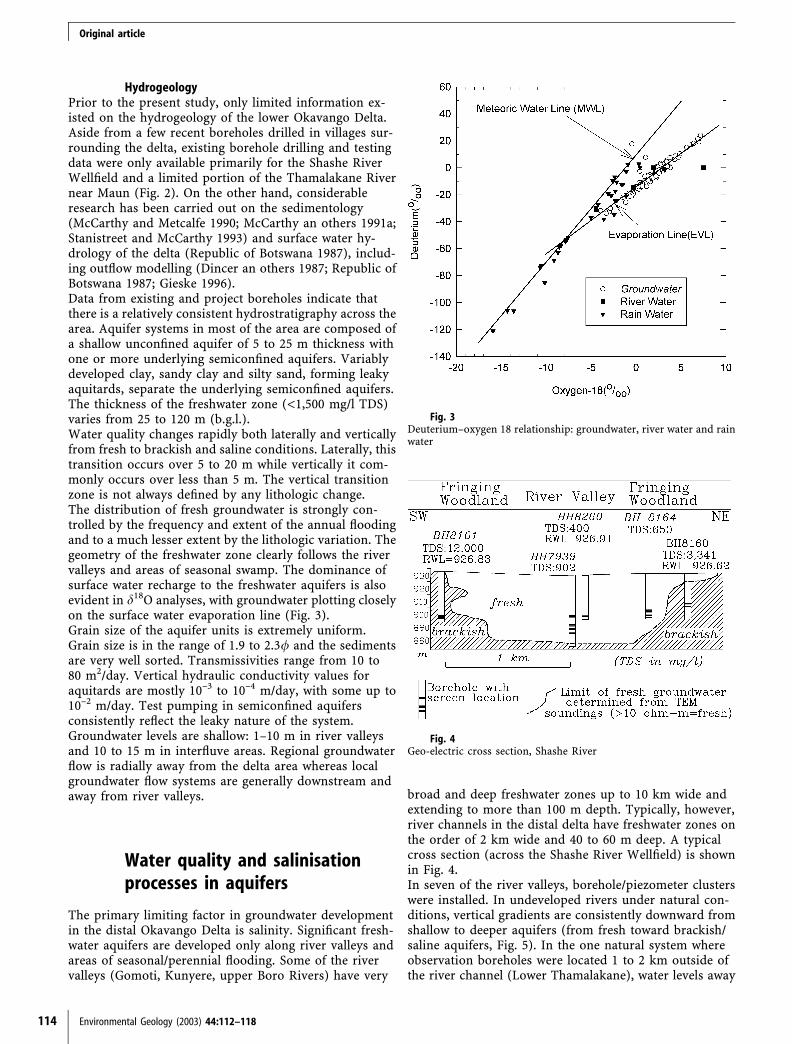
HydrogeologyPrior to the present study, only limited information ex-isted on the hydrogeology of the lower Okavango Delta.Aside from a few recent boreholes drilled in villages sur-rounding the delta, existing borehole drilling and testingdata were only available primarily for the Shashe RiverWellfield and a limited portion of the Thamalakane Rivernear Maun (Fig. 2). On the other hand, considerableresearch has been carried out on the sedimentology(McCarthy and Metcalfe 1990; McCarthy an others 1991a;Stanistreet and McCarthy 1993) and surface water hy-drology of the delta (Republic of Botswana 1987), includ-ing outflow modelling (Dincer an others 1987; Republic ofBotswana 1987; Gieske 1996).Data from existing and project boreholes indicate thatthere is a relatively consistent hydrostratigraphy across thearea. Aquifer systems in most of the area are composed ofa shallow unconfined aquifer of 5 to 25 m thickness withone or more underlying semiconfined aquifers. Variablydeveloped clay, sandy clay and silty sand, forming leakyaquitards, separate the underlying semiconfined aquifers.The thickness of the freshwater zone (<1,500 mg/l TDS)varies from 25 to 120 m (b.g.l.).Water quality changes rapidly both laterally and verticallyfrom fresh to brackish and saline conditions. Laterally, thistransition occurs over 5 to 20 m while vertically it com-monly occurs over less than 5 m. The vertical transitionzone is not always defined by any lithologic change.The distribution of fresh groundwater is strongly con-trolled by the frequency and extent of the annual floodingand to a much lesser extent by the lithologic variation. Thegeometry of the freshwater zone clearly follows the rivervalleys and areas of seasonal swamp. The dominance ofsurface water recharge to the freshwater aquifers is alsoevident in d18O analyses, with groundwater plotting closelyon the surface water evaporation line (Fig. 3).Grain size of the aquifer units is extremely uniform.Grain size is in the range of 1.9 to 2.3/ and the sedimentsare very well sorted. Transmissivities range from 10 to80 m2/day. Vertical hydraulic conductivity values foraquitards are mostly 10–3 to 10–4 m/day, with some up to10–2 m/day. Test pumping in semiconfined aquifersconsistently reflect the leaky nature of the system.Groundwater levels are shallow: 1–10 m in river valleysand 10 to 15 m in interfluve areas. Regional groundwaterflow is radially away from the delta area whereas localgroundwater flow systems are generally downstream andaway from river valleys.
Water quality and salinisationprocesses in aquifers
The primary limiting factor in groundwater developmentin the distal Okavango Delta is salinity. Significant fresh-water aquifers are developed only along river valleys andareas of seasonal/perennial flooding. Some of the rivervalleys (Gomoti, Kunyere, upper Boro Rivers) have very
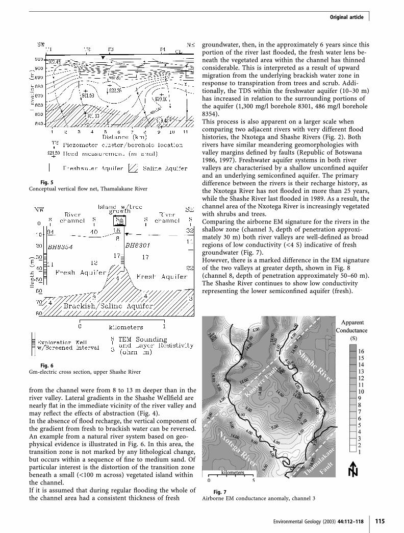
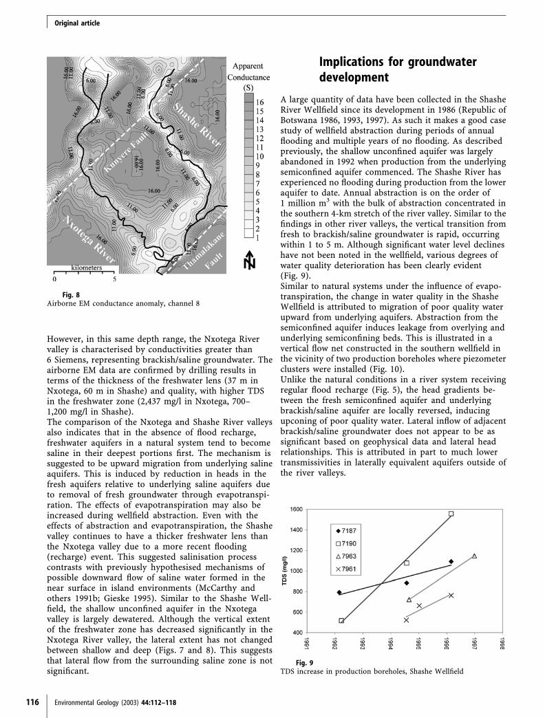
broad and deep freshwater zones up to 10 km wide andextending to more than 100 m depth. Typically, however,river channels in the distal delta have freshwater zones onthe order of 2 km wide and 40 to 60 m deep. A typicalcross section (across the Shashe River Wellfield) is shownin Fig. 4.In seven of the river valleys, borehole/piezometer clusterswere installed. In undeveloped rivers under natural con-ditions, vertical gradients are consistently downward fromshallow to deeper aquifers (from fresh toward brackish/saline aquifers, Fig. 5). In the one natural system whereobservation boreholes were located 1 to 2 km outside ofthe river channel (Lower Thamalakane), water levels away
Fig. 3Deuterium–oxygen 18 relationship: groundwater, river water and rainwater
Fig. 4Geo-electric cross section, Shashe River
Original article
114 Environmental Geology (2003) 44:112–118
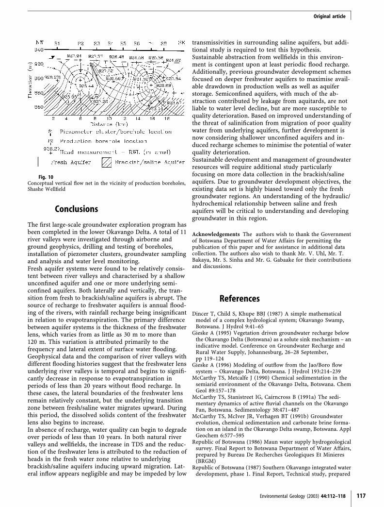
from the channel were from 8 to 13 m deeper than in theriver valley. Lateral gradients in the Shashe Wellfield arenearly flat in the immediate vicinity of the river valley andmay reflect the effects of abstraction (Fig. 4).In the absence of flood recharge, the vertical component ofthe gradient from fresh to brackish water can be reversed.An example from a natural river system based on geo-physical evidence is illustrated in Fig. 6. In this area, thetransition zone is not marked by any lithological change,but occurs within a sequence of fine to medium sand. Ofparticular interest is the distortion of the transition zonebeneath a small (<100 m across) vegetated island withinthe channel.If it is assumed that during regular flooding the whole ofthe channel area had a consistent thickness of fresh
groundwater, then, in the approximately 6 years since thisportion of the river last flooded, the fresh water lens be-neath the vegetated area within the channel has thinnedconsiderable. This is interpreted as a result of upwardmigration from the underlying brackish water zone inresponse to transpiration from trees and scrub. Addi-tionally, the TDS within the freshwater aquifer (10–30 m)has increased in relation to the surrounding portions ofthe aquifer (1,300 mg/l borehole 8301, 486 mg/l borehole8354).This process is also apparent on a larger scale whencomparing two adjacent rivers with very different floodhistories, the Nxotega and Shashe Rivers (Fig. 2). Bothrivers have similar meandering geomorphologies withvalley margins defined by faults (Republic of Botswana1986, 1997). Freshwater aquifer systems in both rivervalleys are characterised by a shallow unconfined aquiferand an underlying semiconfined aquifer. The primarydifference between the rivers is their recharge history, asthe Nxotega River has not flooded in more than 25 years,while the Shashe River last flooded in 1989. As a result, thechannel area of the Nxotega River is increasingly vegetatedwith shrubs and trees.Comparing the airborne EM signature for the rivers in theshallow zone (channel 3, depth of penetration approxi-mately 30 m) both river valleys are well-defined as broadregions of low conductivity (<4 S) indicative of freshgroundwater (Fig. 7).However, there is a marked difference in the EM signatureof the two valleys at greater depth, shown in Fig. 8(channel 8, depth of penetration approximately 50–60 m).The Shashe River continues to show low conductivityrepresenting the lower semiconfined aquifer (fresh).
Fig. 5Conceptual vertical flow net, Thamalakane River
Fig. 6Gm-electric cross section, upper Shashe River
Fig. 7Airborne EM conductance anomaly, channel 3
Original article
Environmental Geology (2003) 44:112–118 115
However, in this same depth range, the Nxotega Rivervalley is characterised by conductivities greater than6 Siemens, representing brackish/saline groundwater. Theairborne EM data are confirmed by drilling results interms of the thickness of the freshwater lens (37 m inNxotega, 60 m in Shashe) and quality, with higher TDSin the freshwater zone (2,437 mg/l in Nxotega, 700–1,200 mg/l in Shashe).The comparison of the Nxotega and Shashe River valleysalso indicates that in the absence of flood recharge,freshwater aquifers in a natural system tend to becomesaline in their deepest portions first. The mechanism issuggested to be upward migration from underlying salineaquifers. This is induced by reduction in heads in thefresh aquifers relative to underlying saline aquifers dueto removal of fresh groundwater through evapotranspi-ration. The effects of evapotranspiration may also beincreased during wellfield abstraction. Even with theeffects of abstraction and evapotranspiration, the Shashevalley continues to have a thicker freshwater lens thanthe Nxotega valley due to a more recent flooding(recharge) event. This suggested salinisation processcontrasts with previously hypothesised mechanisms ofpossible downward flow of saline water formed in thenear surface in island environments (McCarthy andothers 1991b; Gieske 1995). Similar to the Shashe Well-field, the shallow unconfined aquifer in the Nxotegavalley is largely dewatered. Although the vertical extentof the freshwater zone has decreased significantly in theNxotega River valley, the lateral extent has not changedbetween shallow and deep (Figs. 7 and 8). This suggeststhat lateral flow from the surrounding saline zone is notsignificant.
Implications for groundwaterdevelopment
A large quantity of data have been collected in the ShasheRiver Wellfield since its development in 1986 (Republic ofBotswana 1986, 1993, 1997). As such it makes a good casestudy of wellfield abstraction during periods of annualflooding and multiple years of no flooding. As describedpreviously, the shallow unconfined aquifer was largelyabandoned in 1992 when production from the underlyingsemiconfined aquifer commenced. The Shashe River hasexperienced no flooding during production from the loweraquifer to date. Annual abstraction is on the order of1 million m3 with the bulk of abstraction concentrated inthe southern 4-km stretch of the river valley. Similar to thefindings in other river valleys, the vertical transition fromfresh to brackish/saline groundwater is rapid, occurringwithin 1 to 5 m. Although significant water level declineshave not been noted in the wellfield, various degrees ofwater quality deterioration has been clearly evident(Fig. 9).Similar to natural systems under the influence of evapo-transpiration, the change in water quality in the ShasheWellfield is attributed to migration of poor quality waterupward from underlying aquifers. Abstraction from thesemiconfined aquifer induces leakage from overlying andunderlying semiconfining beds. This is illustrated in avertical flow net constructed in the southern wellfield inthe vicinity of two production boreholes where piezometerclusters were installed (Fig. 10).Unlike the natural conditions in a river system receivingregular flood recharge (Fig. 5), the head gradients be-tween the fresh semiconfined aquifer and underlyingbrackish/saline aquifer are locally reversed, inducingupconing of poor quality water. Lateral inflow of adjacentbrackish/saline groundwater does not appear to be assignificant based on geophysical data and lateral headrelationships. This is attributed in part to much lowertransmissivities in laterally equivalent aquifers outside ofthe river valleys.
Fig. 9TDS increase in production boreholes, Shashe Wellfield
Fig. 8Airborne EM conductance anomaly, channel 8
Original article
116 Environmental Geology (2003) 44:112–118
Conclusions
The first large-scale groundwater exploration program hasbeen completed in the lower Okavango Delta. A total of 11river valleys were investigated through airborne andground geophysics, drilling and testing of boreholes,installation of piezometer clusters, groundwater samplingand analysis and water level monitoring.Fresh aquifer systems were found to be relatively consis-tent between river valleys and characterised by a shallowunconfined aquifer and one or more underlying semi-confined aquifers. Both laterally and vertically, the tran-sition from fresh to brackish/saline aquifers is abrupt. Thesource of recharge to freshwater aquifers is annual flood-ing of the rivers, with rainfall recharge being insignificantin relation to evapotranspiration. The primary differencebetween aquifer systems is the thickness of the freshwaterlens, which varies from as little as 30 m to more than120 m. This variation is attributed primarily to thefrequency and lateral extent of surface water flooding.Geophysical data and the comparison of river valleys withdifferent flooding histories suggest that the freshwater lensunderlying river valleys is temporal and begins to signifi-cantly decrease in response to evapotranspiration inperiods of less than 20 years without flood recharge. Inthese cases, the lateral boundaries of the freshwater lensremain relatively constant, but the underlying transitionzone between fresh/saline water migrates upward. Duringthis period, the dissolved solids content of the freshwaterlens also begins to increase.In absence of recharge, water quality can begin to degradeover periods of less than 10 years. In both natural rivervalleys and wellfields, the increase in TDS and the reduc-tion of the freshwater lens is attributed to the reduction ofheads in the fresh water zone relative to underlyingbrackish/saline aquifers inducing upward migration. Lat-eral inflow appears negligible and may be impeded by low
transmissivities in surrounding saline aquifers, but addi-tional study is required to test this hypothesis.Sustainable abstraction from wellfields in this environ-ment is contingent upon at least periodic flood recharge.Additionally, previous groundwater development schemesfocused on deeper freshwater aquifers to maximise avail-able drawdown in production wells as well as aquiferstorage. Semiconfined aquifers, with much of the ab-straction contributed by leakage from aquitards, are notliable to water level decline, but are more susceptible toquality deterioration. Based on improved understanding ofthe threat of salinification from migration of poor qualitywater from underlying aquifers, further development isnow considering shallower unconfined aquifers and in-duced recharge schemes to minimise the potential of waterquality deterioration.Sustainable development and management of groundwaterresources will require additional study particularlyfocusing on more data collection in the brackish/salineaquifers. Due to groundwater development objectives, theexisting data set is highly biased toward only the freshgroundwater regions. An understanding of the hydraulic/hydrochemical relationship between saline and freshaquifers will be critical to understanding and developinggroundwater in this region.
Acknowledgements The authors wish to thank the Governmentof Botswana Department of Water Affairs for permitting thepublication of this paper and for assistance in additional datacollection. The authors also wish to thank Mr. V. Uhl, Mr. T.Bakaya, Mr. S. Sinha and Mr. G. Gabaake for their contributionsand discussions.
References
Dincer T, Child S, Khupe BBJ (1987) A simple mathematicalmodel of a complex hydrological system; Okavango Swamp,Botswana. J Hydrol 9:41–65
Gieske A (1995) Vegetation driven groundwater recharge belowthe Okavango Delta (Botswana) as a solute sink mechanism – anindicative model. Conference on Groundwater Recharge andRural Water Supply, Johannesburg, 26–28 September,pp 119–124
Gieske A (1996) Modeling of outflow from the Jao/Boro flowsystem – Okavango Delta, Botswana. J Hydrol 193:214–239
McCarthy TS, Metcalfe J (1990) Chemical sedimentation in thesemiarid environment of the Okavango Delta, Botswana. ChemGeol 89:157–178
McCarthy TS, Stanistreet IG, Cairncross B (1991a) The sedi-mentary dynamics of active fluvial channels on the OkavangoFan, Botswana. Sedimentology 38:471–487
McCarthy TS, McIver JR, Verhagen BT (1991b) Groundwaterevolution, chemical sedimentation and carbonate brine forma-tion on an island in the Okavango Delta swamp, Botswana. ApplGeochem 6:577–595
Republic of Botswana (1986) Maun water supply hydrogeologicalsurvey. Final Report to Botswana Department of Water Affairs,prepared by Bureau De Recherches Geologiques Et Minieres(BRGM)
Republic of Botswana (1987) Southern Okavango integrated waterdevelopment, phase 1. Final Report, Technical study, prepared
Fig. 10Conceptual vertical flow net in the vicinity of production boreholes,Shashe Wellfield
Original article
Environmental Geology (2003) 44:112–118 117
by Snowy Mountains Engineering Corporation for the Depart-ment of Water Affairs, Gaborone, Botswana
Republic of Botswana (1993) Data report on Shashe Maun pilotborehole construction project, September 1992–March 1993,prepared by Department of Water Affairs, Gaborone, Botswana
Republic of Botswana (1997) Maun groundwater developmentproject, phase I: exploration and resource assessment. FinalReport to Botswana Department of Water Affairs, prepared byEastend Investments
Stanistreet IG, McCarthy TS (1993) The Okavango Fan and theclassification of fan systems. Sediment Geol 85:115–133
Thangarajan M, Linn F, Uhl V, Bakaya TB, Gabaake G (1997)Modelling an inland delta aquifer system to evolve pre-development management schemes: a case study in UpperThamalakane River valley, Botswana, southern Africa. EnvironGeol 38(4):285–295
Thomas DSG, Shaw PA (1991) The Kalahari environment.Cambridge University Press, Cambridge
Wilson BH, Dincer T (1976) An introduction to the hydrologyand hydrography of the Okavango Delta. Symposium on theOkavango Delta, Botswana Society, Gaborone, pp 33–48
Original article
118 Environmental Geology (2003) 44:112–118