Embed Size (px)
Citation preview
1
THE INFLUENCE OF TECTONIC MODELS ON SEISMIC HAZARD ASSESSMENTS IN PAPUA NEW GUINEA
Lawrence Anton1, Gary Gibson2 and Kevin McCue3
1School of Geosciences, Monash University, Wellington Road, Clayton, Victoria 3800, Australia, Email: [email protected]; Tel: +61 3 99054973; Fax: +61 3 99054903 2School of Geosciences, Monash University, Melbourne, and Seismology Research Centre, Environmental Systems & Services, Melbourne, Victoria, Australia 3Australian Seismological Centre, Canberra, ACT, Australia AUTHORS Lawrence Anton is a seismologist with the Government-run Port Moresby Geophysical Observatory, Port Moresby, Papua New Guinea. He is currently at Monash University, Melbourne, completing a Master of Science Degree.
Gary Gibson established the Seismology Research Centre in 1976 and is an Honorary Research Fellow at Monash University. He is chairman of the executive committee of the International Seismological Centre. His interests are in observational seismology and its’ practical problems. Kevin McCue is Director of the Australian Seismological Centre, a small Canberra-based engineering seismology consulting firm, and Adjunct Professor at CQU. He was co-founder of AEES with Charles Bubb and David Rossiter and has been on the committee as Secretary, national delegate to IAEE and Newsletter editor since its inception. ABSTRACT The first stage of an earthquake hazard study is to develop an understanding of the tectonics and the resulting earthquake distribution of the region. The choice of tectonic model for earthquake hazard assessments in Papua New Guinea (PNG) may result in very different assessments of earthquake risk at any location. Three different models are presented here representing the opinion of each of the authors. Relevant up-to-date data including, regional geology, geophysics, geodesy, but principally shallow seismicity have been used to justify the existence of the plate boundaries in each model. We then attempt to reconcile the three choices to remove some of the uncertainty in risk estimates. The lengths of the identified boundaries are used to add constraint to the maximum magnitude.
1
INTRODUCTION The PNG region we have adopted is that used by Everingham (1974) and includes the Indonesian Province of Papua in the west, and the Solomon Islands in the east. It encompasses the region within latitudes 0º and 12.0ºS and longitudes 130º and 163ºE (see Figure 1). As is true of earthquake-prone regions, the seismicity of Papua New Guinea (PNG) is concentrated on plate boundaries. The most intense seismic activity is along the subduction zones where plates are in collision. Other boundaries characterized by sea-floor spreading and transform faulting, mostly left-lateral shearing, are also prominent. What constitutes a plate boundary is critical to this study. A useable definition is that a plate boundary is one outlined by a continuous zone of shallow moderate-sized earthquakes. A simple consequence of this definition is: no shallow earthquakes - no boundary. The plates cannot simply glide past each other, rather as they interact stress builds up in both plates until the strength of rock in the boundary fault interface is exceeded and the fabric of the brittle upper crust fractures, causing fault displacement and earthquakes. There may exist zones where stress accumulation is slow, possibly evidenced by less intense seismic activity. As well, the rate of recurrence of earthquakes in these other such zones may be longer than the existing earthquake catalogue. Overview of hazard estimates The published work of many investigators has been given due consideration. Brookes (1969) was the first to draw up an earthquake hazard map of the region, well before the theory of Plate Tectonics had been formulated. Beca, Carter, Hollings and Ferner (1978) were employed to develop a building code for Papua New Guinea and for this they evaluated the hazard. Interestingly, their independent studies of West Papua and PNG earthquake risk used models that do not match at their junction. Gaull (1969) and many others assessed earthquake hazard at specific sites in PNG. Jury and others (1982) reevaluated the hazard in PNG for a new building code but their map was criticised by McCue (1984) on the basis that it didn’t mirror the then accepted plate tectonic model of the region, and published an alternative hazard map. Denham and Smith (1993) reviewed earthquake hazard assessments in the Southwest Pacific region, while Ripper and Letz (1993) determined the return periods and probabilities of occurrence of large earthquakes in PNG. The most recent hazard assessment of the whole region was compiled under the aegis of GSHAP (McCue, 1999) which included all published and many unpublished estimates of spot hazards for towns or engineering structures. LITHOSPHERIC PLATES Earthquake activity in PNG is a result of the existence and interaction of lithospheric tectonic plates in the region. Ripper et al (1996) summarized the seismicity of the PNG region in depth ranges, and attributed the occurrences of earthquakes to the complex tectonic structural fabric. Denham (1969) was one of the first to interpret earthquake activity in the region in terms of tectonics. He was followed by Curtis (1973) and many others. Tregoning et al (1998, 1999, 2000), Tregoning and McQueen (2001), Tregoning and Gorbatov (2004), Tregoning (2002)

2
and Wallace et al (2004, 2005) have used GPS observations to measure the absolute velocity of several plates in the region.
Figure 1. Seismicity of the PNG region in the period 1900 to 2002. Red circles denote shallow depths (0-39km), yellow diamonds denote depth range 40-149km, blue triangles denote 150-299km, and green stars denote depths of 300km and greater. Tectonic stress in the region is driven by the collision of the Pacific and Australian Plates, on that there is no argument. The collision zone is not a simple boundary but a complex 3-dimensional shear zone which is where the different interpretations arise. The main boundary, the zone of most intense shallow seismicity, from east to west in our region is along the west coast of the Solomon Is and Bougainville. It bends around the north of the Solomon Sea south of New Britain then across Vitiaz Strait to course along the north coast of the Island of New Guinea (Figure 1). Again there is no argument here. Half of this boundary is at the edge of the Pacific Plate; the Solomons, Bougainville and New Guinea sections. Using the definition outlined earlier, it seems clear that the only part of this zone that directly impacts the Australia Plate is the most south-easterly portion south of Guadalcanal at about 8.5° S in the Solomon Is. So where is the northern edge of the Australian Plate? Following the same definition, the Australian Plate boundary trend westerly from Guadalcanal across the Solomon Sea through Goodenough Is to the Papuan Peninsula whose trend it follows to the NNW around an indenture to the Southern Highlands. This part of the boundary along the Southern Highlands (Ripper and McCue, 1982) trends parallel to the north coast of New Guinea to about 140°E where it swings around to almost westerly and then joins the Sunda Arc near about 134°E turning to the southeast.
3
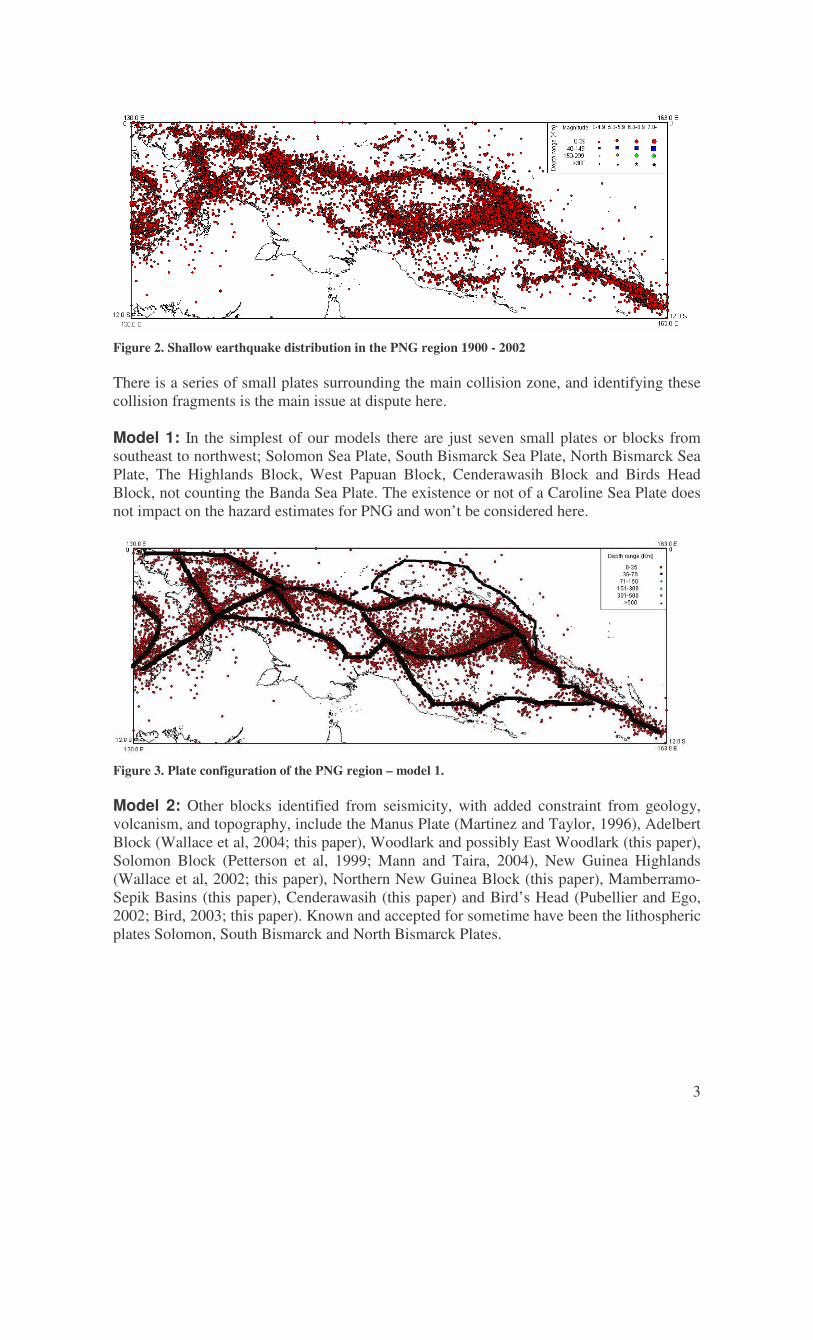
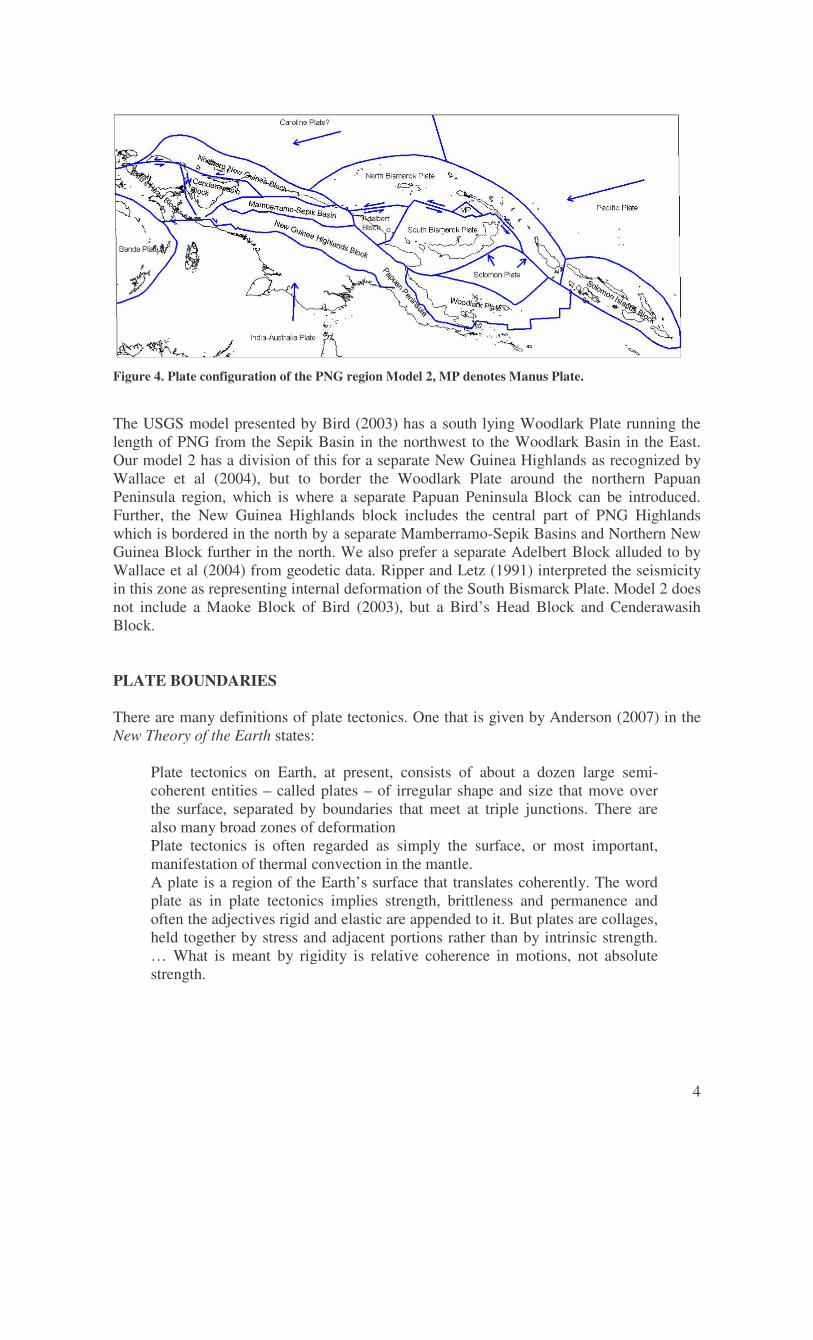
Figure 2. Shallow earthquake distribution in the PNG region 1900 - 2002 There is a series of small plates surrounding the main collision zone, and identifying these collision fragments is the main issue at dispute here. Model 1: In the simplest of our models there are just seven small plates or blocks from southeast to northwest; Solomon Sea Plate, South Bismarck Sea Plate, North Bismarck Sea Plate, The Highlands Block, West Papuan Block, Cenderawasih Block and Birds Head Block, not counting the Banda Sea Plate. The existence or not of a Caroline Sea Plate does not impact on the hazard estimates for PNG and won’t be considered here.
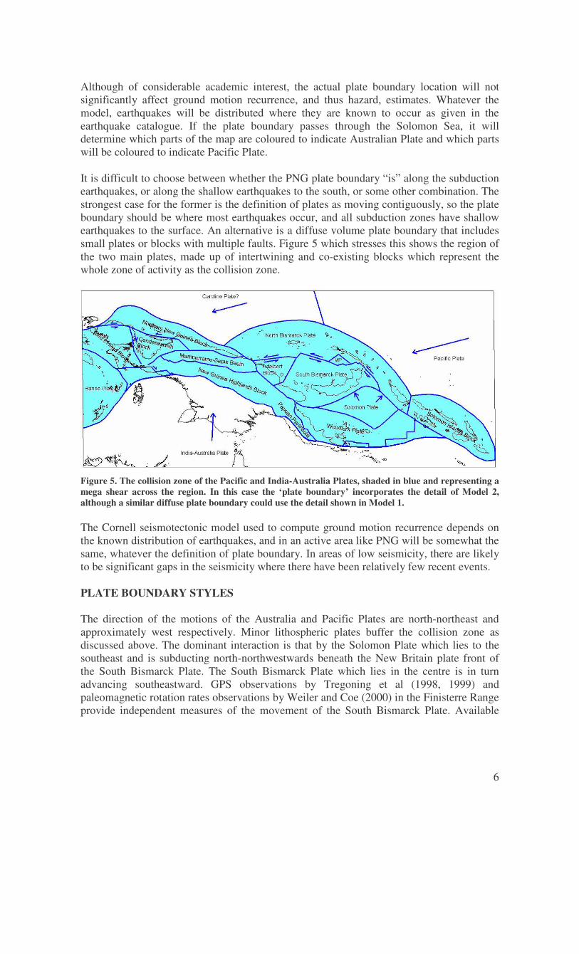
Figure 3. Plate configuration of the PNG region – model 1. Model 2: Other blocks identified from seismicity, with added constraint from geology, volcanism, and topography, include the Manus Plate (Martinez and Taylor, 1996), Adelbert Block (Wallace et al, 2004; this paper), Woodlark and possibly East Woodlark (this paper), Solomon Block (Petterson et al, 1999; Mann and Taira, 2004), New Guinea Highlands (Wallace et al, 2002; this paper), Northern New Guinea Block (this paper), Mamberramo-Sepik Basins (this paper), Cenderawasih (this paper) and Bird’s Head (Pubellier and Ego, 2002; Bird, 2003; this paper). Known and accepted for sometime have been the lithospheric plates Solomon, South Bismarck and North Bismarck Plates.
4
Figure 4. Plate configuration of the PNG region Model 2, MP denotes Manus Plate. The USGS model presented by Bird (2003) has a south lying Woodlark Plate running the length of PNG from the Sepik Basin in the northwest to the Woodlark Basin in the East. Our model 2 has a division of this for a separate New Guinea Highlands as recognized by Wallace et al (2004), but to border the Woodlark Plate around the northern Papuan Peninsula region, which is where a separate Papuan Peninsula Block can be introduced. Further, the New Guinea Highlands block includes the central part of PNG Highlands which is bordered in the north by a separate Mamberramo-Sepik Basins and Northern New Guinea Block further in the north. We also prefer a separate Adelbert Block alluded to by Wallace et al (2004) from geodetic data. Ripper and Letz (1991) interpreted the seismicity in this zone as representing internal deformation of the South Bismarck Plate. Model 2 does not include a Maoke Block of Bird (2003), but a Bird’s Head Block and Cenderawasih Block. PLATE BOUNDARIES There are many definitions of plate tectonics. One that is given by Anderson (2007) in the New Theory of the Earth states:
Plate tectonics on Earth, at present, consists of about a dozen large semi-coherent entities – called plates – of irregular shape and size that move over the surface, separated by boundaries that meet at triple junctions. There are also many broad zones of deformation Plate tectonics is often regarded as simply the surface, or most important, manifestation of thermal convection in the mantle. A plate is a region of the Earth’s surface that translates coherently. The word plate as in plate tectonics implies strength, brittleness and permanence and often the adjectives rigid and elastic are appended to it. But plates are collages, held together by stress and adjacent portions rather than by intrinsic strength. … What is meant by rigidity is relative coherence in motions, not absolute strength.

5
Plate boundaries are defined by relative movement, and thus earthquake activity. This implies that the plate boundary is delineated by a continuous zone of shallow moderate-sized earthquakes. In particular, McCue strongly argues this point stating that, “no shallow earthquakes - no boundary”. Plate boundaries: lines, planes or volumes The definition of a plate boundary is not simple in practice. It might be assumed that if plates are 3D objects that are moving relative to one another, then the plate boundary must be a two dimensional plane, and because there is relative movement between the plates, this will be a fault plane. The most common representation of plate boundaries is on a simple map. Here the plate boundary is represented as a line separating the upper surfaces of the plates. That is, it represents the surface expression of the plate boundary fault plane. The boundary between plates is not necessarily vertical, although in the case of some strike-slip boundaries it may be close to vertical. With subduction, the plate boundary may be dipping at an angle from relatively shallow to very steep. Other plate boundaries may be much more complex. If the plate boundary is a fault that outcrops at the surface, then one practical question is whether the plate boundary is continuous or discontinuous. On a small scale, many faults divide into a series of sub-parallel en-echelon faults. On a large scale, more complex sharing of relative motion between faults might be expected, such as the relationship between subduction earthquakes and related surface strike-slip faulting. Defining a plate boundary as the fault across which most relative motion between the plates is occurring would require that plate boundaries are discontinuous It might be expected that the intraplate earthquakes within a subducting plate should be regarded as “plate boundary earthquakes”. If this were the case, then the plate boundary would be a volume rather than a plane. Another possible definition of plate boundary might include all of the sub-plates and blocks associated with the two plates. The relative movement would then include one or more sub-boundaries, each with relative movement. Where plate boundaries are curved, this may include major subduction zones and large near-parallel strike-slip faults, such as the Sumatera Fault. The plates themselves would then have constant (on a small scale) or near uniformly changing relative motion (on a large scale) along the boundary. For the PNG region the latter definition, which gives a volume plate boundary, may have width to over one thousand kilometres and depth to hundreds of kilometres. That is, the total relative motion between the plates is taken up across a series of fault planes, each dependent on the others, resulting in a constant or near uniformly varying motion between the plates. Plate boundaries are not static, and inherently change as plates move. Anderson (2007) compares plates with floating bubbles or foams, constantly coalescing and changing shapes and sizes. Islands of bubbles can move coherently even though they are far from rigid. At times they may swap to a neighbouring ‘plate’. Definitions of plates usually do not consider the origin of the rocks within any sub-plate or block – only relative movement.
6
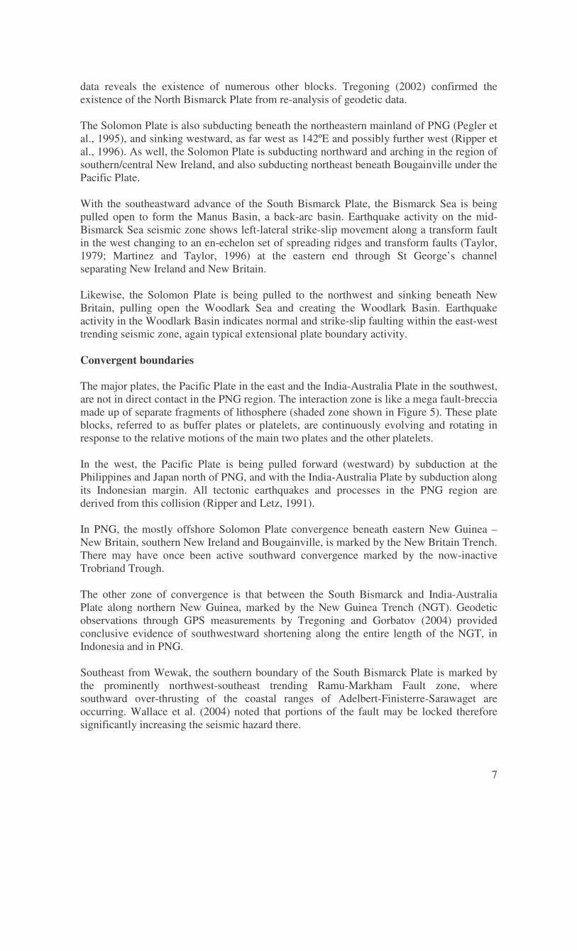
Although of considerable academic interest, the actual plate boundary location will not significantly affect ground motion recurrence, and thus hazard, estimates. Whatever the model, earthquakes will be distributed where they are known to occur as given in the earthquake catalogue. If the plate boundary passes through the Solomon Sea, it will determine which parts of the map are coloured to indicate Australian Plate and which parts will be coloured to indicate Pacific Plate. It is difficult to choose between whether the PNG plate boundary “is” along the subduction earthquakes, or along the shallow earthquakes to the south, or some other combination. The strongest case for the former is the definition of plates as moving contiguously, so the plate boundary should be where most earthquakes occur, and all subduction zones have shallow earthquakes to the surface. An alternative is a diffuse volume plate boundary that includes small plates or blocks with multiple faults. Figure 5 which stresses this shows the region of the two main plates, made up of intertwining and co-existing blocks which represent the whole zone of activity as the collision zone.
Figure 5. The collision zone of the Pacific and India-Australia Plates, shaded in blue and representing a mega shear across the region. In this case the ‘plate boundary’ incorporates the detail of Model 2, although a similar diffuse plate boundary could use the detail shown in Model 1. The Cornell seismotectonic model used to compute ground motion recurrence depends on the known distribution of earthquakes, and in an active area like PNG will be somewhat the same, whatever the definition of plate boundary. In areas of low seismicity, there are likely to be significant gaps in the seismicity where there have been relatively few recent events. PLATE BOUNDARY STYLES The direction of the motions of the Australia and Pacific Plates are north-northeast and approximately west respectively. Minor lithospheric plates buffer the collision zone as discussed above. The dominant interaction is that by the Solomon Plate which lies to the southeast and is subducting north-northwestwards beneath the New Britain plate front of the South Bismarck Plate. The South Bismarck Plate which lies in the centre is in turn advancing southeastward. GPS observations by Tregoning et al (1998, 1999) and paleomagnetic rotation rates observations by Weiler and Coe (2000) in the Finisterre Range provide independent measures of the movement of the South Bismarck Plate. Available
7
data reveals the existence of numerous other blocks. Tregoning (2002) confirmed the existence of the North Bismarck Plate from re-analysis of geodetic data. The Solomon Plate is also subducting beneath the northeastern mainland of PNG (Pegler et al., 1995), and sinking westward, as far west as 142ºE and possibly further west (Ripper et al., 1996). As well, the Solomon Plate is subducting northward and arching in the region of southern/central New Ireland, and also subducting northeast beneath Bougainville under the Pacific Plate. With the southeastward advance of the South Bismarck Plate, the Bismarck Sea is being pulled open to form the Manus Basin, a back-arc basin. Earthquake activity on the mid-Bismarck Sea seismic zone shows left-lateral strike-slip movement along a transform fault in the west changing to an en-echelon set of spreading ridges and transform faults (Taylor, 1979; Martinez and Taylor, 1996) at the eastern end through St George’s channel separating New Ireland and New Britain. Likewise, the Solomon Plate is being pulled to the northwest and sinking beneath New Britain, pulling open the Woodlark Sea and creating the Woodlark Basin. Earthquake activity in the Woodlark Basin indicates normal and strike-slip faulting within the east-west trending seismic zone, again typical extensional plate boundary activity. Convergent boundaries The major plates, the Pacific Plate in the east and the India-Australia Plate in the southwest, are not in direct contact in the PNG region. The interaction zone is like a mega fault-breccia made up of separate fragments of lithosphere (shaded zone shown in Figure 5). These plate blocks, referred to as buffer plates or platelets, are continuously evolving and rotating in response to the relative motions of the main two plates and the other platelets. In the west, the Pacific Plate is being pulled forward (westward) by subduction at the Philippines and Japan north of PNG, and with the India-Australia Plate by subduction along its Indonesian margin. All tectonic earthquakes and processes in the PNG region are derived from this collision (Ripper and Letz, 1991). In PNG, the mostly offshore Solomon Plate convergence beneath eastern New Guinea – New Britain, southern New Ireland and Bougainville, is marked by the New Britain Trench. There may have once been active southward convergence marked by the now-inactive Trobriand Trough. The other zone of convergence is that between the South Bismarck and India-Australia Plate along northern New Guinea, marked by the New Guinea Trench (NGT). Geodetic observations through GPS measurements by Tregoning and Gorbatov (2004) provided conclusive evidence of southwestward shortening along the entire length of the NGT, in Indonesia and in PNG. Southeast from Wewak, the southern boundary of the South Bismarck Plate is marked by the prominently northwest-southeast trending Ramu-Markham Fault zone, where southward over-thrusting of the coastal ranges of Adelbert-Finisterre-Sarawaget are occurring. Wallace et al. (2004) noted that portions of the fault may be locked therefore significantly increasing the seismic hazard there.
8
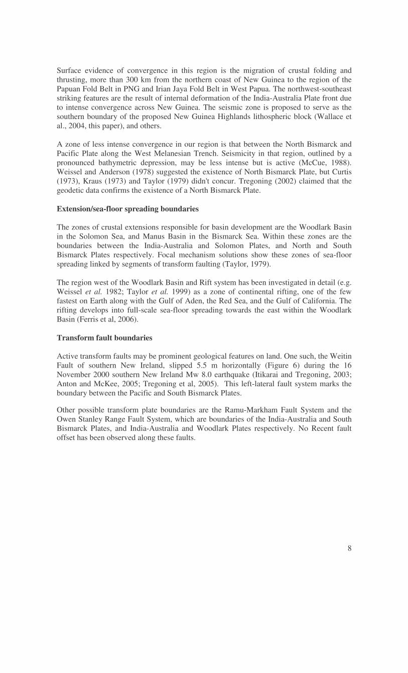
Surface evidence of convergence in this region is the migration of crustal folding and thrusting, more than 300 km from the northern coast of New Guinea to the region of the Papuan Fold Belt in PNG and Irian Jaya Fold Belt in West Papua. The northwest-southeast striking features are the result of internal deformation of the India-Australia Plate front due to intense convergence across New Guinea. The seismic zone is proposed to serve as the southern boundary of the proposed New Guinea Highlands lithospheric block (Wallace et al., 2004, this paper), and others. A zone of less intense convergence in our region is that between the North Bismarck and Pacific Plate along the West Melanesian Trench. Seismicity in that region, outlined by a pronounced bathymetric depression, may be less intense but is active (McCue, 1988). Weissel and Anderson (1978) suggested the existence of North Bismarck Plate, but Curtis (1973), Kraus (1973) and Taylor (1979) didn't concur. Tregoning (2002) claimed that the geodetic data confirms the existence of a North Bismarck Plate. Extension/sea-floor spreading boundaries The zones of crustal extensions responsible for basin development are the Woodlark Basin in the Solomon Sea, and Manus Basin in the Bismarck Sea. Within these zones are the boundaries between the India-Australia and Solomon Plates, and North and South Bismarck Plates respectively. Focal mechanism solutions show these zones of sea-floor spreading linked by segments of transform faulting (Taylor, 1979). The region west of the Woodlark Basin and Rift system has been investigated in detail (e.g. Weissel et al. 1982; Taylor et al. 1999) as a zone of continental rifting, one of the few fastest on Earth along with the Gulf of Aden, the Red Sea, and the Gulf of California. The rifting develops into full-scale sea-floor spreading towards the east within the Woodlark Basin (Ferris et al, 2006). Transform fault boundaries Active transform faults may be prominent geological features on land. One such, the Weitin Fault of southern New Ireland, slipped 5.5 m horizontally (Figure 6) during the 16 November 2000 southern New Ireland Mw 8.0 earthquake (Itikarai and Tregoning, 2003; Anton and McKee, 2005; Tregoning et al, 2005). This left-lateral fault system marks the boundary between the Pacific and South Bismarck Plates. Other possible transform plate boundaries are the Ramu-Markham Fault System and the Owen Stanley Range Fault System, which are boundaries of the India-Australia and South Bismarck Plates, and India-Australia and Woodlark Plates respectively. No Recent fault offset has been observed along these faults.
9
Figure 6. The only known surface faulting in the PNG region on the Weitin Fault, New Ireland. Photograph courtesy of Ima Itikarai of Rabaul Volcanological Observatory (including annotations). Earthquake rupture lengths: the influence of tectonic blocks Rupture lengths along plate boundaries may be restricted to only a few hundreds of kilometers making it possible to predict the maximum credible earthquake on each segment. Great earthquakes that have occurred in the region have reached magnitude 8. The southern New Ireland Earthquake of 16 November 2000 was a great earthquake with a probable rupture length of about 200 km. The New Britain Trench region from Huon Gulf to southern New Ireland and the other arm from southern New Ireland to south Bougainville have generated great subduction earthquakes in the past (Everingham, 1975). The rupture of the full length of the trench during an earthquake originating from either end/side of the trench may be restricted by the significant bend in the northern Solomon Sea, therefore significantly reducing the rupture length to about half. Possible lengths of rupture could therefore total only about 500 km, accounting for a possible maximum magnitude of 8.5. Apart from the zone of the New Britain Trench, the New Guinea Trench is another zone which could account for possible rupture lengths of several hundreds of kilometres up to at least 500 km. The seismic zone extending southeast along the Solomon Islands, the convergent boundary between the Pacific and India-Australia Plates, is also capable of a rupture length of several hundred kilometres. Here though, the New Britain Trench is not continuous and the collision is not linear, according to available seismicity, topographic, bathymetric and free air gravity anomaly data. The Woodlark Basin is being subducted northeastward at the trench, and its’ effect on the generation of a large through-going rupture is not clear. However, the possible rupture length could be as long as up to 600 km.
10
CONCLUDING REMARKS Seismic hazard in PNG is high by World standards, reflecting the rapid rate of collision of the Australian and Pacific Plates, three times faster than the relative motion across the San Andreas Fault for example. This interaction is spread across multiple plate boundaries or seismic zones and this must be accounted for in mapping the hazard. Several different models have been presented here but no single model is preferred and this uncertainty should be accommodated in any PSHA of the region. Engineers involved in development proposals in PNG are advised to investigate the additional risk of secondary hazards generated by large earthquakes including earthquake aftershocks, tsunamis, landslides and floods. Volcanic hazards tend to be fairly obvious. REFERENCES Anderson, D.L., 2007. New Theory of the Earth, Cambridge University Press ISBN 978-0-
521-84959-3 Anton, L., and McKee, C.O., 2005. The Great Earthquake of 16 November 2000 and
Associated Seismo-Tectonic Events near the Pacific-Solomon-South Bismarck Plate Triple Junction in Papua New Guinea. Papua New Guinea Geological Survey Report 2005/1.
Beca, Carter, Hollings and Ferner, 1978. Indonesian Earthquake Study (6 volumes), Wellington, New Zealand (unpbl.)
Bird, P., 2003. An updated digital model of plate boundaries. Geochem. Geophys. Geosyst., 4(3), 1-52.
Brookes, J.A., 1969. Earthquake Activity and Seismic Risk in Papua and New Guinea. BMR Australia Report 74.
Curtis, J.W., 1973. Plate tectonics and the Papua New Guinea Solomon Islands region. Journal of the Geological Society Australia, 70, 21-36.
Denham, D., 1969. Distribution of earthquakes in the New Guinea-Solomon Islands region. Journal of Geophysical Research, 74, 4290-4299.
Denham, D., and Smith, W., 1993. Earthquake Hazard Assessment in the Australian Southwest Pacific Region. A review of the Status Quo. Annali di Geofisica, xxxvi, June-July 1993.
Everingham, I.B., 1974. Large Earthquakes in the New Guinea – Solomon Islands Area. Tectonophysics, 23, 323-338.
Everingham, I.B., 1975. Faulting associated with the major north Solomon Sea earthquakes of 14 and 26 July 1971. Journal of Geological Society of Australia, Vol. 22, Pt. 1, pp. 61-69 March, 1975.
Ferris, Aaron; Abers, Geoffrey A; Zelt, Barry; Taylor, Brian and Roecker, Steve, 2006. Crustal structure across the transition from rifting to spreading: the Woodlark rift system of Papua New Guinea. Geophys. J. Int. (2006) 166, 622–634.
Gaull, B.A., 1969. Seismic Risk at the 20 Principal Towns of Papua New Guinea. MSc Thesis, Univ PNG, Geology Department.
Itikarai, I., and Tregoning, P., 2003. The 16 November 2000 southern New Ireland earthquake and its aftershocks. Papua New Guinea Geological Survey Report 2003/1.
Jury, R.D., Hollings, J.P., and Fraser, I.A.N., 1982. The Development of Seismic Zones and the Evaluation of Lateral Loading for Earthquake Resistant Design of Buildings in
11
Papua New Guinea. Bulletin of the New Zealand National Society for Earthquake Engineering, 15, 3, 123-139.
Krause, D.C., 1973. Crustal plates of the Bismarck and Solomon Seas, in Oceanography of the South Pacific, edited by R. FRASER (Nat. Comm. for UNESCO, Wellington), 271-280.
Mann, Paul and Taira, Asahiko, 2004. Global tectonic significance of the Solomon Islands and Ontong Java Plateau convergent zone. Tectonophysics 389, 137– 190.
McCue, K.F., 1984. Shallow Earthquakes, tectonics and Seismic Zoning in Papua New Guinea. Bulletin New Zealand National Society for Earthquake Engineering, 17 (4), 292-295.
McCue, K.F., 1988. Earthquakes and crustal stress in the North Bismarck Sea, in Marlow, M.S., Dadisman, S.V., and Exon, N.F., (editors), GEOLOGY AND OFFSHORE RESOURCES OF PACIFIC ISLAND ARCS - NEW IRELAND AND MANUS REGION, PAPUA NEW GUINEA, Circum-Pacific Council for Energy and Mineral Resources Earth Science Series 9, p.41-46. Circum-Pacific Council for Energy and Mineral Resources, Houston, Texas.
McCue, K., 1999. Seismic Hazard Mapping In Australia , The Southwest Pacific And Southeast Asia. in The Global Seismic Hazard Assessment Program 1992-1999, Ed D. Giardini GSHAP Summary Volume, Annali di Geofisica, 1999.
McGuire, R. K., 1993. Computations of seismic hazard. Annali di Geofisica, v. 36, p. 181-200.
Martinez, F., and B. Taylor, 1996. Fast backarc spreading, rifting, and microplate rotation, between transform faults in the Manus Basin, Bismarck Sea, Mar. Geophy. Res., 18, 203–224.
Pegler Das, S., and Woodhouse, J.H., 1995. A seismological study of the eastern New Guinea and the western Solomon Sea regions and its tectonic implications.
Petterson,_M.G., Babbs, T., Neal, C.R., Mahoney, J.J, Saunders, A.D., Duncan, R.A, Tolia, D., Magu, R., Qopoto, C., Mahoa, H., and Natogga, D., 1999: Geological–tectonic framework of Solomon Islands, SW Pacific: crustal accretion and growth within an intra-oceanic setting. Tectonophysics, 301, 35–60.
Pubellier, Manuel., and Ego, Fre´de´ric, 2002. Anatomy of an escape tectonic zone: Western Irian Jaya (Indonesia). Tectonics, vol. 21, no. 4, 10.1029/2001TC901038, 2002
Ripper, I.D., Letz, H., and Anton, L., 1996. Seismicity and seismotectonics of Papua New Guinea presented in earthquake depth zones. Papua New Guinea Geological Survey Report 96/9.
Ripper, I.D., and Letz, H., 1993. Return periods and probabilities of occurrence of large earthquakes in Papua New Guinea. Papua New Guinea Geological Survey Report 93/1.
Ripper, I.D., and Letz, H., 1991. Distribution and origin of large earthquakes in the Papua New Guinea region, 1900-1989. Papua New Guinea Geological Survey Report 91/5.
Ripper, I.D., and McCue, K.F., 1983. The seismic zone of the Papuan Fold Belt. BMR Journal of Australian Geology and Geophysics, 8; 2, pages 142-156.
Taylor, B., 1979. Bismarck Sea: evolution of a back-arc basin. Geology 7, 171-174. Taylor, B., Goodliffe, A.M. & Martinez, F., 1999. How continents break up; insights from
Papua New Guinea, Journal of Geophysical Research, 104(4), 7497–7512. Tregoning, P., Sambridge, M., McQueen, H., Toulmin, S., and Nicholson, T., 2005.
Tectonic interpretation of aftershock relocation in eastern Papua New Guinea using teleseismic data and the arrival pattern method. Geophys. J. Int., 160, 1103-1111.
12
Tregoning, P., and Gorbatov, A., 2004. Evidence for active subduction at the New Guinea Trench. Geophysical Research Letters, 31, L13608, doi:10.1029/2004GL020190.
Tregoning, P., 2002. Plate kinematics in the western Pacific derived from geodetic observations. Journal of Geophysical Research, 107, 7-1 – 7-8.
Tregoning, P., and McQueen, H., 2001. Resolving slip-vector azimuths and plate motion along the southern boundary of the South Bismarck Plate, Papua New Guinea. Australian Journal of Earth Sciences, 48(2001): 745-750.
Tregoning, Paul; McQueen, Herb; Lambeck, Kurt; Jackson, Russel; Little, Rod; Saunders, Steve and Robert Rosa, 2000. Present-day crustal motion in Papua New Guinea. LETTER Earth Planets Space, 52, 727–730.
Tregoning, Paul, Jackson, Russell J., McQueen, Herbert; Lambeck, Kurt; Stevens, Colleen; Little, Rodney P.; Curley, Robert and Rosa, Robert, 1999. Motion of the South Bismarck Plate, Papua New Guinea. Geophysical Research Letters, Vol. 26, No. 23, Pages 3517-3520.
Tregoning, P., Lambeck, K., Stolz, A., Morgan, P., McCluske, S.C., Van der Beek, P., McQueen, H., Jackson, R.R., Little, R.P., Laing, A., and Murphy, B., 1998. Estimation of current plate motion in Papua New Guinea from Global Positioning System observations. Journal of Geophysical Research, 103, 12181-12203.
Wallace, Laura M., McCaffrey, Robert, Beavan, John and Ellis, Susan, 2005. Rapid microplate rotations and backarc rifting at the transition between collision and subduction. Geological Society of America. Geology; November 2005; v. 33; no. 11; p. 857–860.
Wallace, Laura M., Stevens, C., Silver, E., McCaffrey, R., Loratung, W., Suvenia Hasiata, Stanaway, R., Curley, R., Rosa, R. and Taugaloidi, J., 2004. GPS and seismological constraints on active tectonics and arc-continent collision in Papua New Guinea: Implications for mechanics of microplate rotations in a plate boundary zone. Journal of Geophysical Research, 109, 727-730.
Weiler, P. D., and Coe, R. S., 2000. Rotations in the actively colliding Finisterre-Arc Terrane: Paleomagnetic constraints on Plio-Pleistocene evolution of the South Bismarck microplate, northeastern Papua New Guinea, Tectonophysics, 316, 297– 325.
Weissel, J.K., Taylor, B., and Karner, G.D., 1982. The opening of the Woodlark Basin, subduction of the Woodlark spreading system, and the evolution of northern Melanesia since mid-Pliocene time. Tectonophysics 87, 253-277.
Weissel, J.K., and Anderson, R.N., 1978. Is there a Caroline Plate? Earth and Planetary Science Letters 41, 143-158.


![[MS-PNG]: Internet Explorer Portable Network Graphics (PNG ...interoperability.blob.core.windows.net/web/MS-PNG/[MS-PNG].pdf · Internet Explorer Portable Network Graphics (PNG)](https://img.pdfslide.net/doc/110x75/5ac310e37f8b9ae06c8bbe56/ms-png-internet-explorer-portable-network-graphics-png-ms-pngpdfinternet.jpg)