Embed Size (px)
Citation preview
The Joplin Tornado – 2014 GLOMW
May 22 Joplin EF5 Tornado• 158 Fatalities (7th deadliest tornado)
• Most killed since 1947 Woodward, OK tornado (181)
1
Photo credit: Reuters
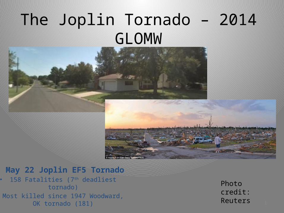
NWS Service Assessment included 5 people; 3 meteorologists, 1 social scientist, 1 public administration specialist – plus various “contributors”.
Five days spent on-site, with nearly 100 total interviews spread amongst:1) Tornado survivors/general public2) NWS Partner Groups – EMs, Media, EOC/Dispatch, Fire Chief3) NWS User Groups – Businesses, Schools, City Officials4) NWS Staff
1
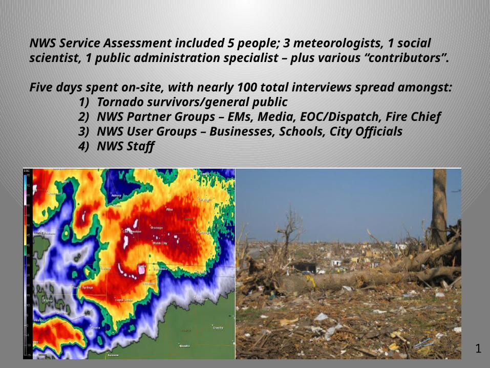
Direct Fatalities: 158 + 4 indirect fatalitiesInjuries: Over 1,100Path Length and Width: 22 miles (6 mi. EF4-5 in Joplin); up to 1 mile wideNumber of Homes Severely Damaged or Destroyed: more than 8000Max Winds: 200 mph$2.8 Billion in Damage
3
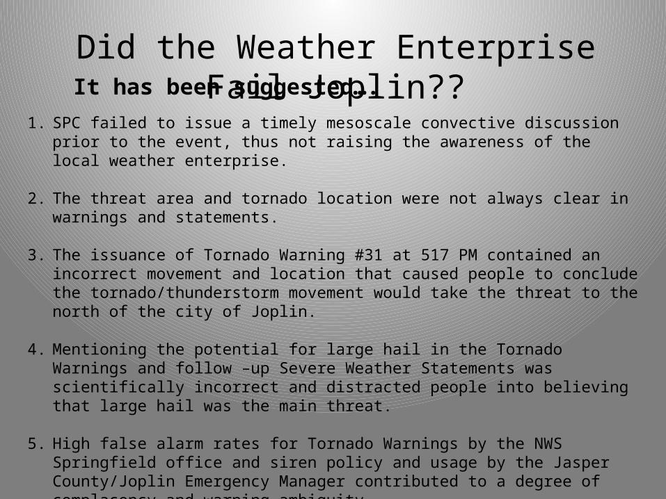
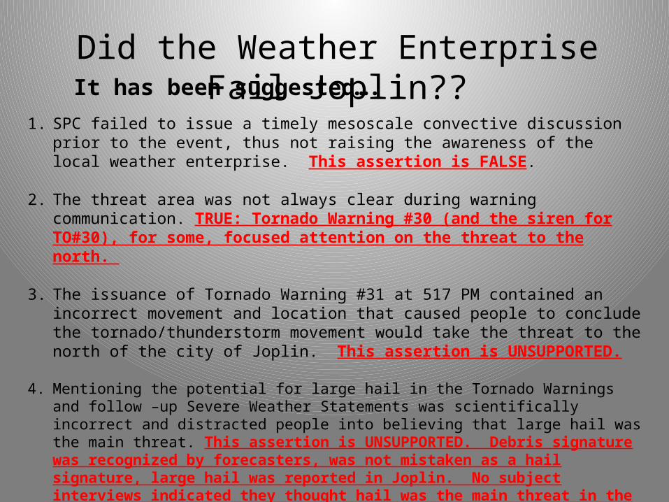
1. SPC failed to issue a timely mesoscale convective discussion prior to the event, thus not raising the awareness of the local weather enterprise.
2. The threat area and tornado location were not always clear in warnings and statements.
3. The issuance of Tornado Warning #31 at 517 PM contained an incorrect movement and location that caused people to conclude the tornado/thunderstorm movement would take the threat to the north of the city of Joplin.
4. Mentioning the potential for large hail in the Tornado Warnings and follow –up Severe Weather Statements was scientifically incorrect and distracted people into believing that large hail was the main threat.
5. High false alarm rates for Tornado Warnings by the NWS Springfield office and siren policy and usage by the Jasper County/Joplin Emergency Manager contributed to a degree of complacency and warning ambiguity.
6. The large number of deaths were due to inadequate warnings – comparing Joplin fatalities to those in a similar tornado in Greensburg KS.
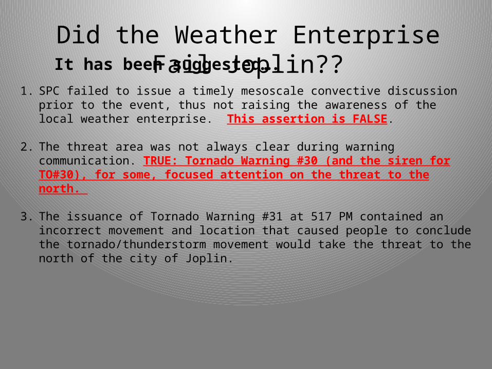
Did the Weather Enterprise Fail Joplin??It has been suggested….
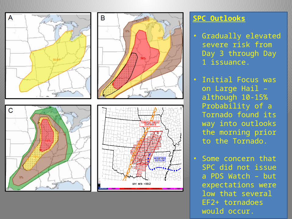
SPC Outlooks
• Gradually elevated severe risk from Day 3 through Day 1 issuance.
• Initial Focus was on Large Hail – although 10-15% Probability of a Tornado found its way into outlooks the morning prior to the Tornado.
• Some concern that SPC did not issue a PDS Watch – but expectations were low that several EF2+ tornadoes would occur.
• Mesoscale Convective Discussion issued at 358 PM discussing supercell tornado and hail threat
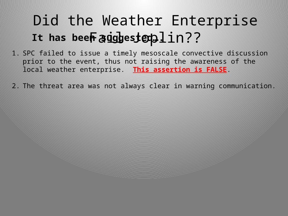
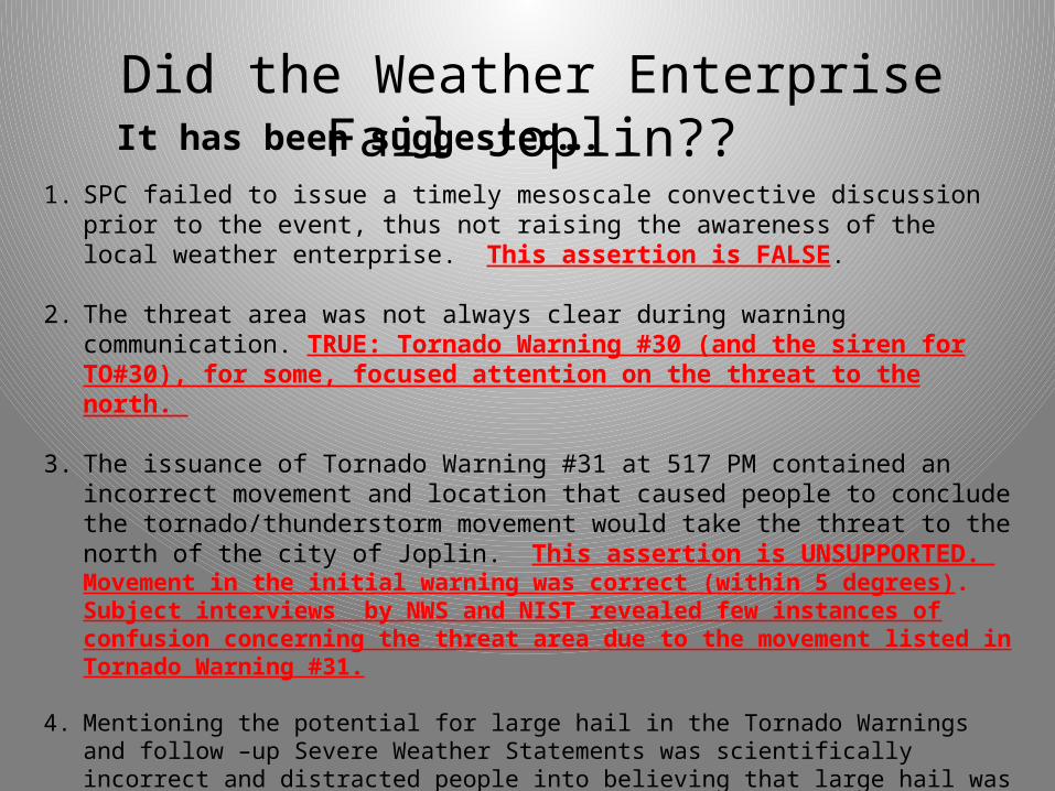
1. SPC failed to issue a timely mesoscale convective discussion prior to the event, thus not raising the awareness of the local weather enterprise. This assertion is FALSE.
2. The threat area was not always clear in warning communication.
Did the Weather Enterprise Fail Joplin??It has been suggested….
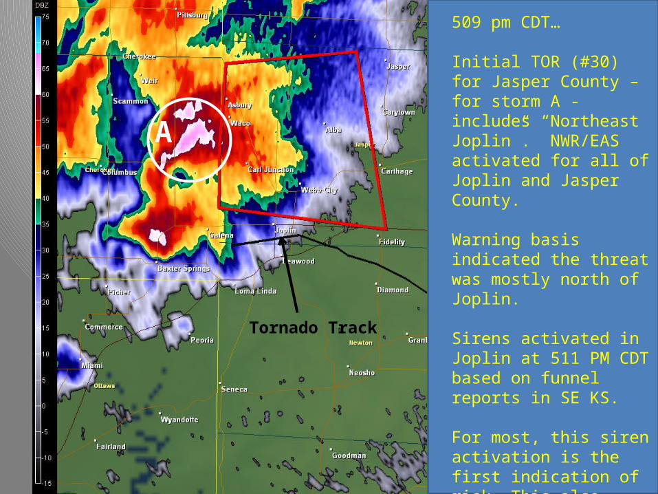
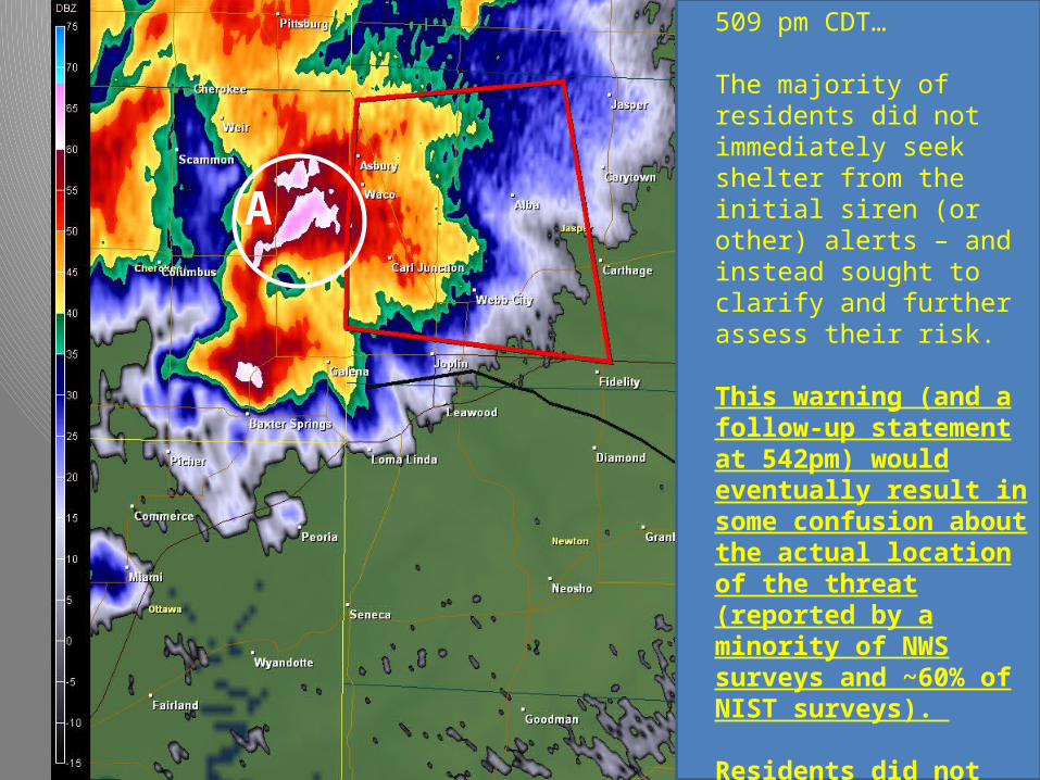
509 pm CDT…
Initial TOR (#30) for Jasper County – for storm A - includes “Northeast Joplin”. NWR/EAS activated for all of Joplin and Jasper County.
Warning basis indicated the threat was mostly north of Joplin.
Sirens activated in Joplin at 511 PM CDT based on funnel reports in SE KS.
For most, this siren activation is the first indication of risk. This also results in some ambiguity concerning the type and degree of the threat.
A
Tornado Track
509 pm CDT…
The majority of residents did not immediately seek shelter from the initial siren (or other) alerts – and instead sought to clarify and further assess their risk.
This warning (and a follow-up statement at 542pm) would eventually result in some confusion about the actual location of the threat (reported by a minority of NWS surveys and ~60% of NIST surveys).
Residents did not ignore warnings (misreported in the media – which led to incorrect claims that “victims were blamed”).
A
1. SPC failed to issue a timely mesoscale convective discussion prior to the event, thus not raising the awareness of the local weather enterprise. This assertion is FALSE.
2. The threat area was not always clear during warning communication. TRUE: Tornado Warning #30 (and the siren for TO#30), for some, focused attention on the threat to the north.
3. The issuance of Tornado Warning #31 at 517 PM contained an incorrect movement and location that caused people to conclude the tornado/thunderstorm movement would take the threat to the north of the city of Joplin.
Did the Weather Enterprise Fail Joplin??It has been suggested….
B
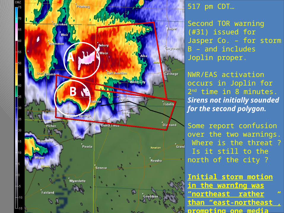
517 pm CDT…
Second TOR warning (#31) issued for Jasper Co. – for storm B – and includes Joplin proper.
NWR/EAS activation occurs in Joplin for 2nd time in 8 minutes. Sirens not initially sounded for the second polygon.
Some report confusion over the two warnings. Where is the threat ? Is it still to the north of the city ?
Initial storm motion in the warning was “northeast” rather than “east-northeast”, prompting one media pundit to claim this caused public confusion and many fatalities. Subject interviews revealed this claim to be unsupported.
A
INX 2207Z
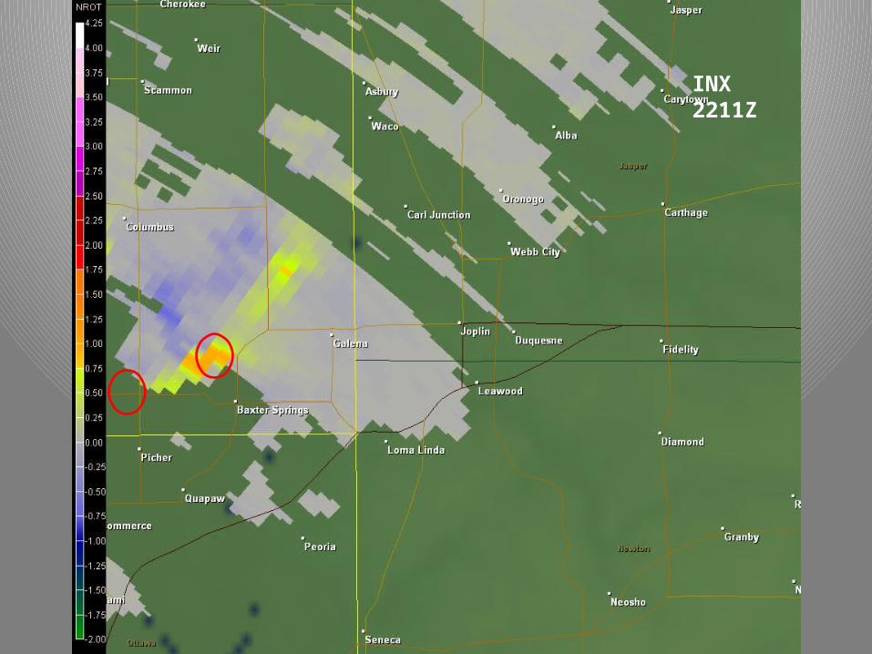
INX 2211Z
INX 2216Z
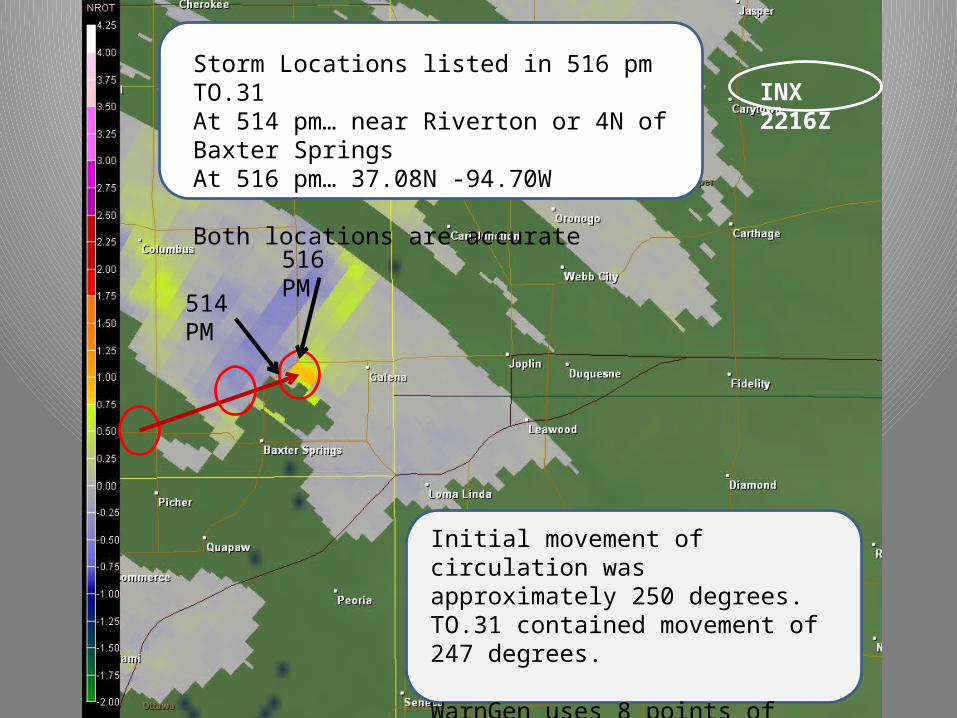
Initial movement of circulation was approximately 250 degrees. TO.31 contained movement of 247 degrees.
WarnGen uses 8 points of compass and cutoff between NE and E is 248 degrees.
Storm Locations listed in 516 pm TO.31At 514 pm… near Riverton or 4N of Baxter SpringsAt 516 pm… 37.08N -94.70W
Both locations are accurate
516 PM
514 PM
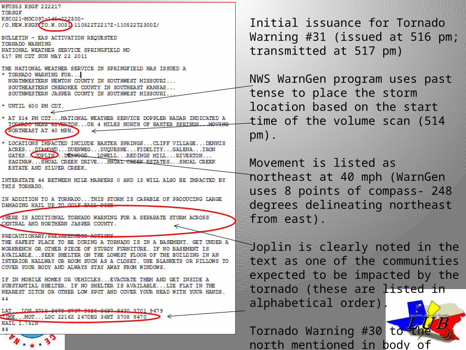
Initial issuance for Tornado Warning #31 (issued at 516 pm; transmitted at 517 pm)
NWS WarnGen program uses past tense to place the storm location based on the start time of the volume scan (514 pm).
Movement is listed as northeast at 40 mph (WarnGen uses 8 points of compass- 248 degrees delineating northeast from east).
Joplin is clearly noted in the text as one of the communities expected to be impacted by the tornado (these are listed in alphabetical order).
Tornado Warning #30 to the north mentioned in body of TOR #31.
WarnGen also lists forecaster-entered storm movement based on radar (247 deg at 36 kts) and projects location to time of product issuance (37.08N 94.70W) at 516 PM.
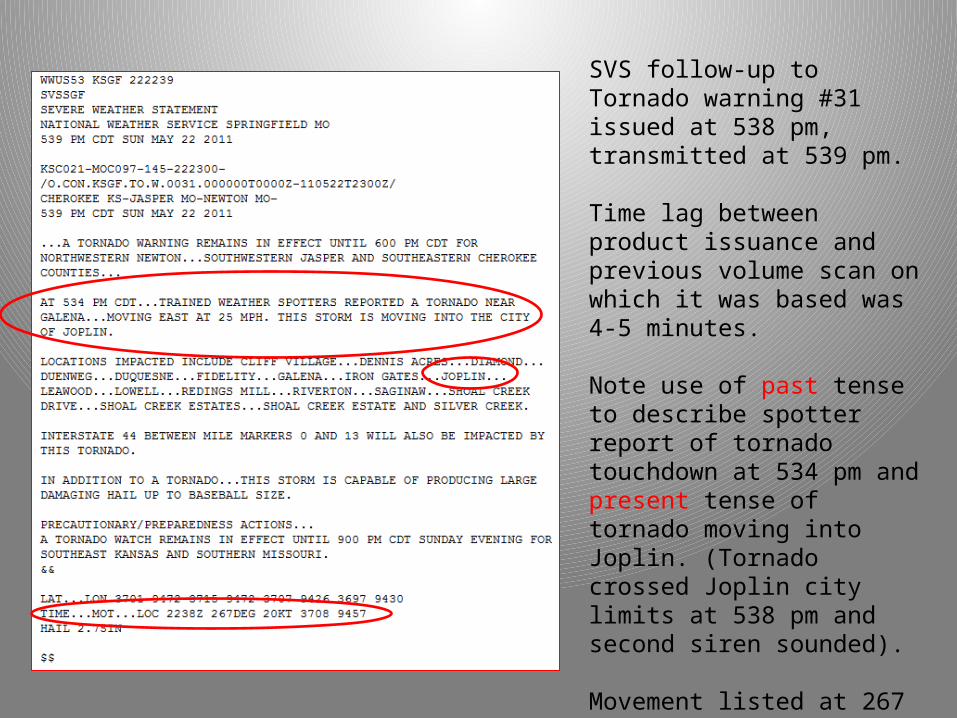
SVS follow-up to Tornado warning #31 issued at 538 pm, transmitted at 539 pm.
Time lag between product issuance and previous volume scan on which it was based was 4-5 minutes.
Note use of past tense to describe spotter report of tornado touchdown at 534 pm and present tense of tornado moving into Joplin. (Tornado crossed Joplin city limits at 538 pm and second siren sounded).
Movement listed at 267 degrees; Initial tornado movement was 258° at 28 mph. – within 10 degrees accuracy.
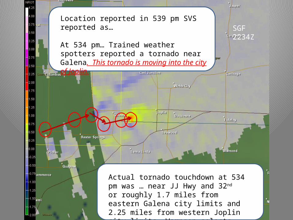
SGF 2234ZLocation reported in 539 pm SVS reported as…
At 534 pm… Trained weather spotters reported a tornado near Galena. This tornado is moving into the city of Joplin.
Actual tornado touchdown at 534 pm was … near JJ Hwy and 32nd or roughly 1.7 miles from eastern Galena city limits and 2.25 miles from western Joplin city limits. Warngen selects the closest city.
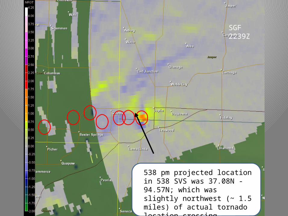
SGF 2239Z
538 pm projected location in 538 SVS was 37.08N -94.57N; which was slightly northwest (~ 1.5 miles) of actual tornado location crossing Schifferdecker at 538 pm.
1. SPC failed to issue a timely mesoscale convective discussion prior to the event, thus not raising the awareness of the local weather enterprise. This assertion is FALSE.
2. The threat area was not always clear during warning communication. TRUE: Tornado Warning #30 (and the siren for TO#30), for some, focused attention on the threat to the north.
3. The issuance of Tornado Warning #31 at 517 PM contained an incorrect movement and location that caused people to conclude the tornado/thunderstorm movement would take the threat to the north of the city of Joplin. This assertion is UNSUPPORTED. Movement in the initial warning was correct (within 5 degrees). Subject interviews by NWS and NIST revealed few instances of confusion concerning the threat area due to the movement listed in Tornado Warning #31.
4. Mentioning the potential for large hail in the Tornado Warnings and follow –up Severe Weather Statements was scientifically incorrect and distracted people into believing that large hail was the main threat.
Did the Weather Enterprise Fail Joplin??It has been suggested….
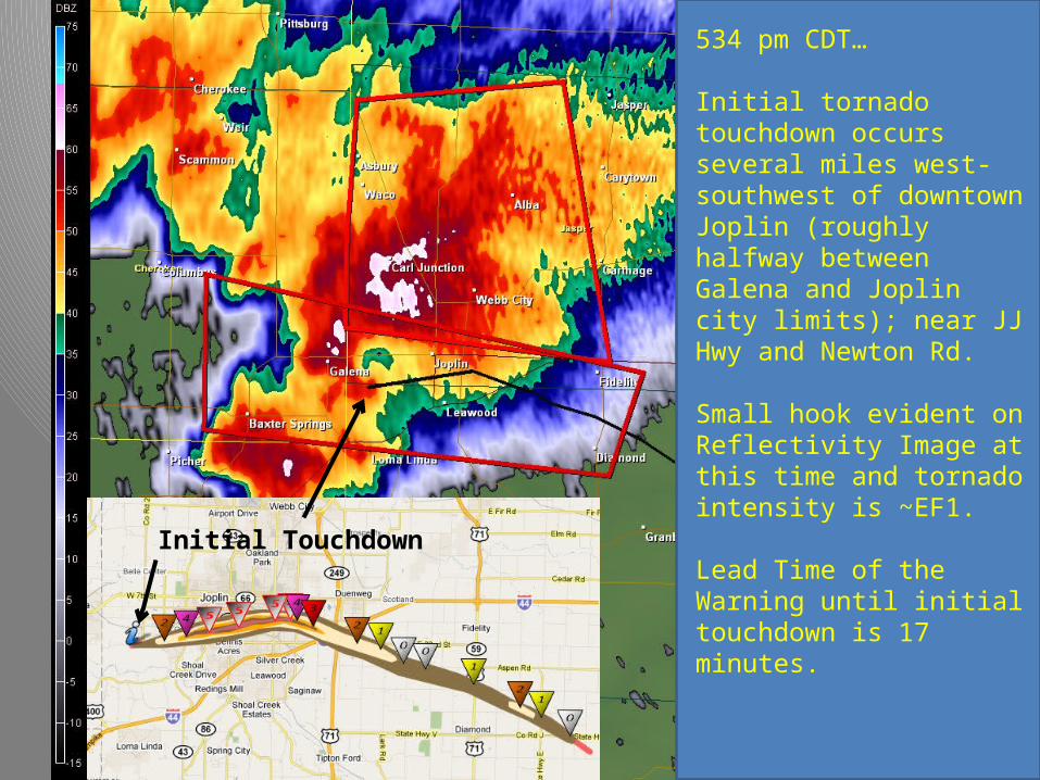
Initial Touchdown
534 pm CDT…
Initial tornado touchdown occurs several miles west-southwest of downtown Joplin (roughly halfway between Galena and Joplin city limits); near JJ Hwy and Newton Rd.
Small hook evident on Reflectivity Image at this time and tornado intensity is ~EF1.
Lead Time of the Warning until initial touchdown is 17 minutes.
Tornado Location
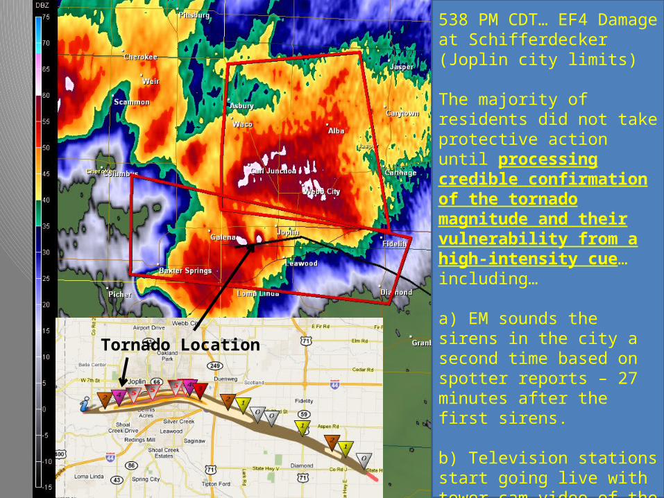
538 PM CDT… EF4 Damage at Schifferdecker (Joplin city limits)
The majority of residents did not take protective action until processing credible confirmation of the tornado magnitude and their vulnerability from a high-intensity cue… including…
a) EM sounds the sirens in the city a second time based on spotter reports – 27 minutes after the first sirens.
b) Television stations start going live with tower cam video of the tornado and telling people to take cover.
c) People physically see the tornado.
Tornado Location
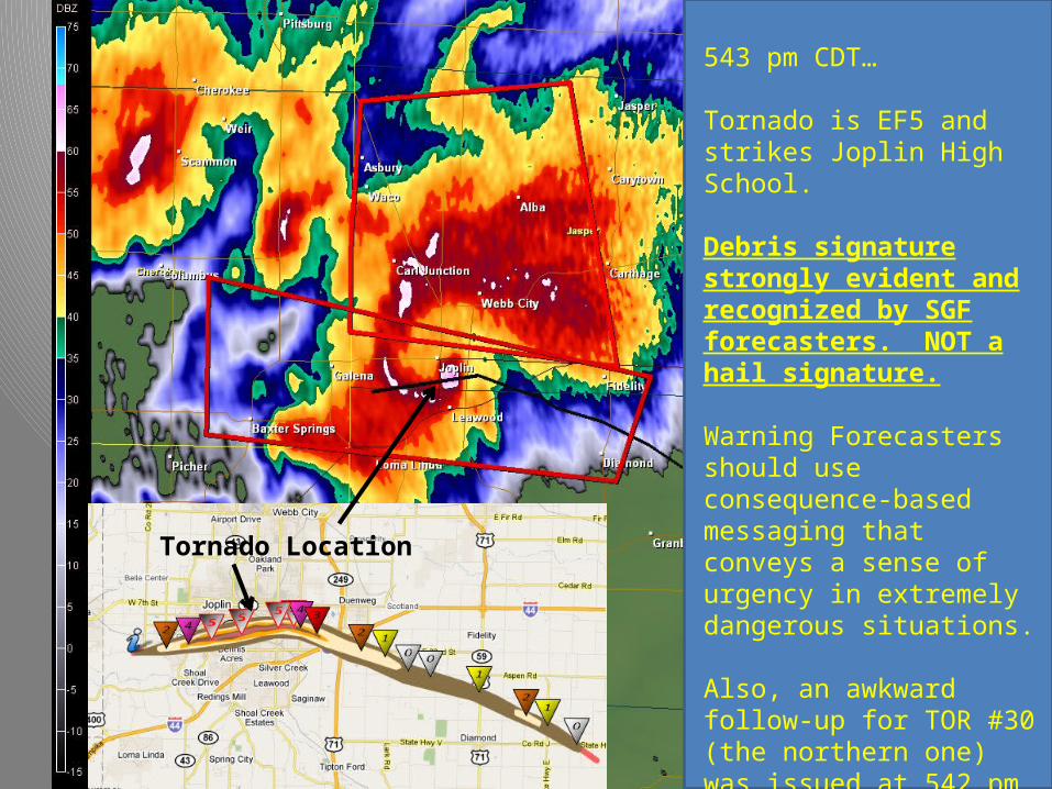
543 pm CDT…
Tornado is EF5 and strikes Joplin High School.
Debris signature strongly evident and recognized by SGF forecasters. NOT a hail signature.
Warning Forecasters should use consequence-based messaging that conveys a sense of urgency in extremely dangerous situations.
Also, an awkward follow-up for TOR #30 (the northern one) was issued at 542 pm briefly adding potential confusion to the message (in effect for 6 minutes).
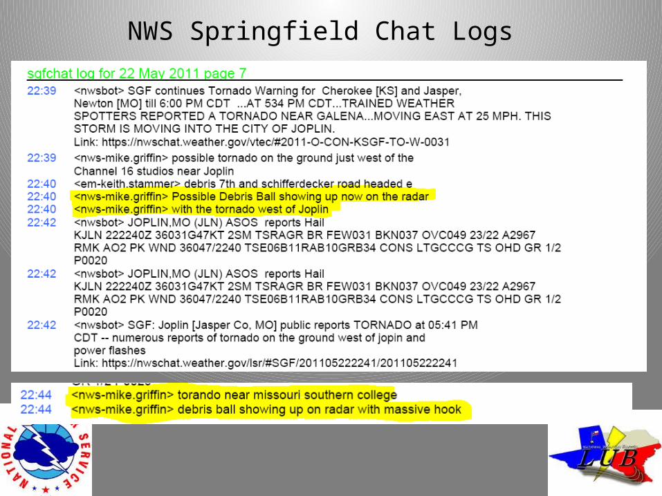
NWS Springfield Chat Logs
1. SPC failed to issue a timely mesoscale convective discussion prior to the event, thus not raising the awareness of the local weather enterprise. This assertion is FALSE.
2. The threat area was not always clear during warning communication. TRUE: Tornado Warning #30 (and the siren for TO#30), for some, focused attention on the threat to the north.
3. The issuance of Tornado Warning #31 at 517 PM contained an incorrect movement and location that caused people to conclude the tornado/thunderstorm movement would take the threat to the north of the city of Joplin. This assertion is UNSUPPORTED.
4. Mentioning the potential for large hail in the Tornado Warnings and follow –up Severe Weather Statements was scientifically incorrect and distracted people into believing that large hail was the main threat. This assertion is UNSUPPORTED. Debris signature was recognized by forecasters, was not mistaken as a hail signature, large hail was reported in Joplin. No subject interviews indicated they thought hail was the main threat in the tornado warning.
5. High false alarm rates for Tornado Warnings by the NWS Springfield office and siren policy and usage by the Jasper County/Joplin Emergency Manager contributed to a degree of complacency and warning ambiguity.
Did the Weather Enterprise Fail Joplin??It has been suggested….
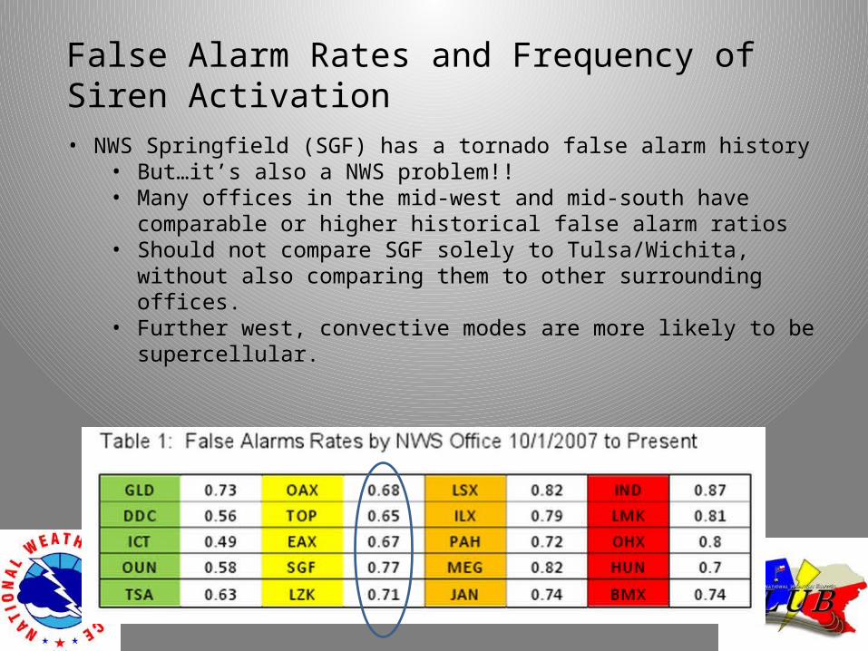
False Alarm Rates and Frequency of Siren Activation
• NWS Springfield (SGF) has a tornado false alarm history• But…it’s also a NWS problem!! • Many offices in the mid-west and mid-south have comparable or higher
historical false alarm ratios• Should not compare SGF solely to Tulsa/Wichita, without also comparing them
to other surrounding offices.• Further west, convective modes are more likely to be supercellular.
• Joplin EM routinely sounds sirens for Severe Thunderstorm Warnings w/winds 75 mph – leading to some ambiguity concerning the type of threat and magnitude of the threat.
• Sirens were sounded following Tornado Warning #30 issuance, but were not sounded again following Tornado Warning #31 – leading to some ambiguity concerning the threat.
• However, it was noted by a large number of people that the 2nd siren blast at 538 pm prompted them to seek shelter as the tornado crossed Joplin City Limits.
• False alarms due to warnings or siren activations do have a negative impact on warning credibility.
False Alarm Rates and Frequency of Siren Activation
1. SPC failed to issue a timely mesoscale convective discussion prior to the event, thus not raising the awareness of the local weather enterprise. This assertion is FALSE.
2. The threat area was not always clear during warning communication. TRUE: Tornado Warning #30 (and the siren for TO#30), for some, focused attention on the threat to the north.
3. The issuance of Tornado Warning #31 at 517 PM contained an incorrect movement and location that caused people to conclude the tornado/thunderstorm movement would take the threat to the north of the city of Joplin. This assertion is UNSUPPORTED.
4. Mentioning the potential for large hail in the Tornado Warnings and follow –up Severe Weather Statements was scientifically incorrect and distracted people into believing that large hail was the main threat. This assertion is UNSUPPORTED.
5. High false alarm rates for Tornado Warnings by the NWS Springfield office and siren policy and usage by the Jasper County/Joplin Emergency Manager contributed to a degree of complacency and warning ambiguity. This assertion is TRUE.
6. The large number of deaths were due to inadequate warnings – comparing Joplin fatalities to those in similar tornadoes in St. Louis MO and in Greensburg KS.
Did the Weather Enterprise Fail Joplin??It has been suggested….
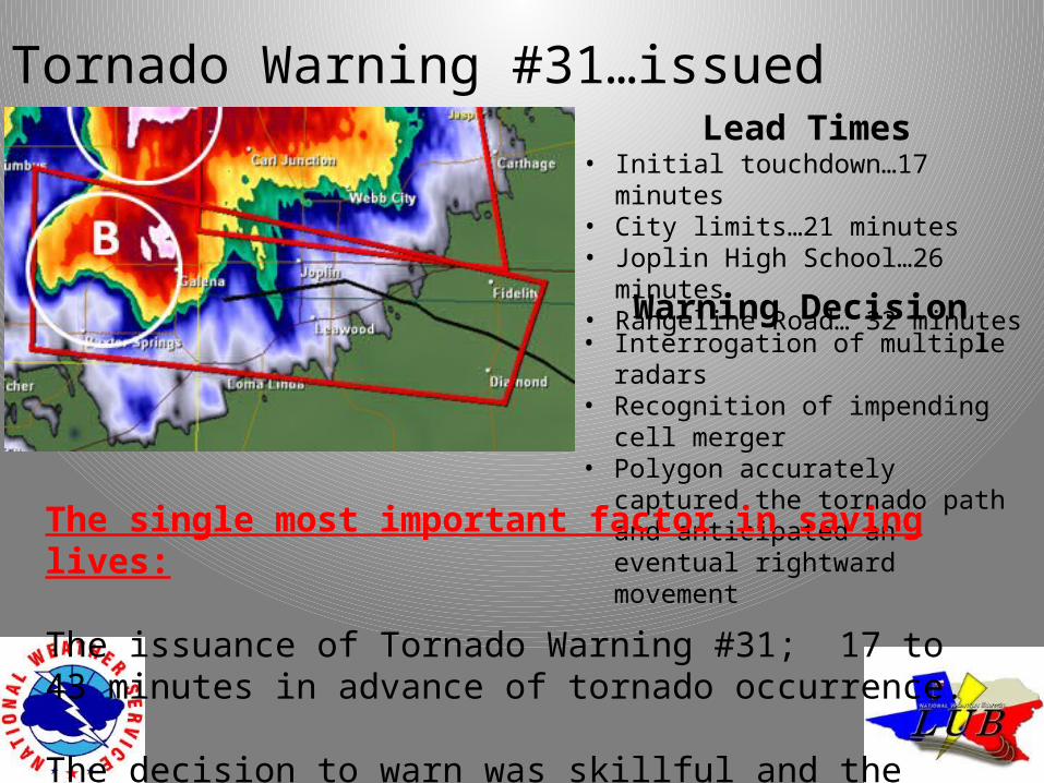
Tornado Warning #31…issued 517 PM CDTLead Times
• Initial touchdown…17 minutes• City limits…21 minutes• Joplin High School…26 minutes• Rangeline Road… 32 minutes
Warning Decision• Interrogation of multiple radars• Recognition of impending cell merger• Polygon accurately captured the
tornado path and anticipated an eventual rightward movement
The single most important factor in saving lives:
The issuance of Tornado Warning #31; 17 to 43 minutes in advance of tornado occurrence.
The decision to warn was skillful and the polygon was accurate.
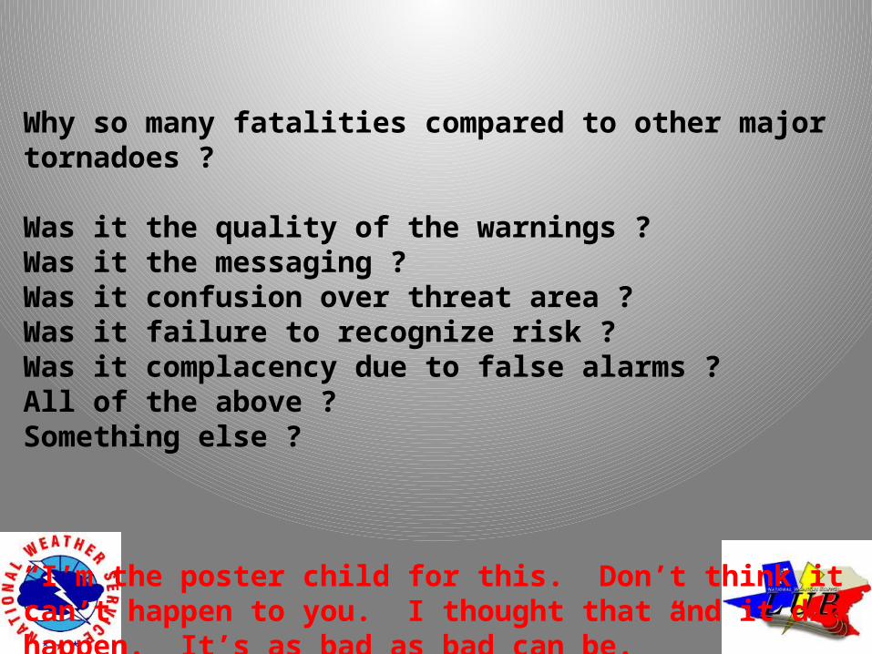
Why so many fatalities compared to other major tornadoes ?
Was it the quality of the warnings ?Was it the messaging ?Was it confusion over threat area ?Was it failure to recognize risk ?Was it complacency due to false alarms ?All of the above ?Something else ?
“I’m the poster child for this. Don’t think it can’t happen to you. I thought that and it did happen. It’s as bad as bad can be. ”
-Mark Rohr, Joplin City Manager