Embed Size (px)
Citation preview
TERENCE R. LEE*
The Management of Shared WaterResources in Latin America
ABSTRACT
There are 58 rivers and lakes in Latin America whose drainagebasins are shared by two or more countries. There are, however, fewexamples in the region of institutions actively engaged in themanagement of shared water resources. This article reviews the stateof the management of shared resources in Latin America andattempts to explain, through economic factors, why there is both solittle apparent interest in the management of international rivers andwhy where agreements have been reached they have generally notbeen effectively implemented.
International boundaries in Latin America are often defined byrivers and other bodies of water. Many other rivers flow across interna-tional frontiers.1 Although many of these shared water resources havebeen subject to treaties and agreement, there are few examples in theregion of institutions actively engaged in the joint management of sharedresources. This article reviews the current state of the management ofshared water resources in Latin America and attempts to explain whythere is so little interest in the management of international rivers in aregion with a long history, at least rhetorically, of cooperation.
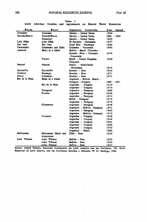
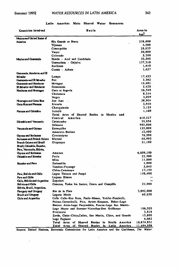
There are 58 rivers and lakes in Latin America whose drainagebasins are shared by two or more countries. Many of these shared waterbodies have been subject to some form of international legal arrangement,either specific to them or within some broader instrument dealingwith border issues (see Table 1).2 In general, with the exception of the
* Terence Lee works for the United Nations Economic Commission for Latin America
and the Caribbean.1. These drainage basins account for over half the area of the countries of the region and
the flows in international rivers are equivalent to more than three-quarters of the totalrun-off. Eighty percent of the total area involved and over three-quarters of the flow isaccounted for, however, by only two river systems, the Amazon and the Rio de la Plata.United Nations, Economic Commission for Latin America and the Caribbean, The Water Re-sources of Latin America and the Caribbean, Estudios e Informes de la CEPAL, NO 53,(1985).
2. A detailed and complete account of the agreements made up to 1975 can be found inJ. L6pez, El Derecho y la Administraci6n de Aguas en Iberoam~rica (1975) (paper presentedto the International Conference on Global Water Law Systems, Valencia).
NATURAL RESOURCES JOURNAL
Latin America: Treaties andTable IAgreements on Shared Water Resources
BasinColoradoGrande/Bravo
Lake GiiijaSan JuanCatatumboAmazon
Maroni
ZarumilaTumbesChiraRio de Ia Plata
RiverColoradoGrande/BravoChamizalLake GflijaSan JuanCatatumbo and ZuliaBasin as a whole
Tacatil
Maroni
ZarumillaPuyangoCatamayoBasin as a whole
Rio de Ia Plata
ParaguayParatl
Pilcomayo
Uruguay
Mchusuma Mchusuma, Mauri andAzucarcro
Lake Titicaca Lake TiticacaLake TiticacaLake Titicaca
Source: United Nations, Economic CommissionResources of Latin America and the Caribbean,
for Latin America and theEstudios c Informics, Na 53,
CaSna
[Vol. 35
Signatory CountriesMexico - United StatesMexico - United StatesMexico - United StatesEl Salvador - GuatemalaCosta Rice - NicaraguaColombia - VenezuelaBolivia - Brazil -Colombia -Ecuador -Peru - Suriname-VenezuelaBrazil - United Kingdom(Guyana)France - Netherlands
(Suriname)Ecuador - PeruEcuador - PeruEcuador - PeruArgentina - Bolivia -Brazil -Paraguay -UruguayArgentina - UruguayArgentina - UruguayArgentina - ParaguayArgentina - ParaguayArgentina - ParaguayBrazil - ParaguayArgentina - ParaguayArgentina - ParaguayArgentina - Bolivia -ParaguayArgentina - ParaguayArgentina - Bolivia -ParaguayArgentina - UruguayArgentina - UruguayArgentina - UruguayArgentina - UruguayArgentina - UruguayArgentina - BrazilChile - Peru
Bolivia - Peru
Bolivia - Peruflolivia - Peru
Year signed19441906 - 19331963195718881903
1978
1940
1915194419711971
1969 - 1971191019731969195819711973197419391941194519721938194619611969197519801929
193519551957
ribbean. The Waterntiago, 1985.
Summer 1995]
Countries involved
Mioad United ts ofAmerica
Mtdand iatenala
Quaemala. Haduras and E
Qatemala and l Salvadoruatemala and 1HIduras
13 Sdlvdu and Itmdur.Hdurss and Mcaragua
Mcarapa ad Gatia RcaChta ca and Pata
Panams ad Gulzabia
Qiambiaand Veaezuela
Vanezuela and tywa
Chyansa and SurinameSNrinamn ad Frech hianaRench Gian and BrazlBrazil. (Okmbis, Buador.Peru, Venezuela. Bilivia,Guyana and SurinamnGambia nd nFwadr
Euador and Peru
Ptru. Blivia and GuilePeru and GdleGuile, Bivia and ArprntinaEblivia and GhileBilivia, Bkanl. ArgntimnParaguay and UruguayWazil and UkuuyGuile and Ariutina
WATER RESOURCES IN LATIN AMERICA
Latin America: Main Shared Water Resources
Basin
Rio Grande or BravoTijuanaConcepci6nYaquiColoradoHondo - Azul and CandelanaUsamacinta - GrijalvaSuchiateCoatin - Achute
LempaPazMotaguaGoascordnCoco or SegoviaCholutecaNegroSan JuanSixaolaChanguinolaJurad6Total Area or Shared Basins in Mexico andCentral AmericaCatatumboOrinocoEssequiboAmacuro-BarimaCourantyneMaroniOiapoque
AmazonPatinMiraZurumiliaTumbes-PuyangoChira-CatamayoLagos Titicaca and Poop6Laguna BlancaZapeleriCancosa, Todos los Santos, Cauca and Cosapilla
Rio de Ia PlataLaguna MerinCalle Calle-Hua Hum, Puelo-Manso. Yelcho-Futalufd,Palena-Carrenleufd, Pico. Aysen-Simpson. Baker-LagoBuenos Aires-Lago Pucyredddn, Pascua-Lago San Martin-Lago Maycr and Srrano-Vizcachas-Don GuillermoPenitenteZurdo, Ciake-Chico.Cullcn, San Martin, Chico, and GrandeLago FagnanoTotal Area or Shared Basins in South AmericaTotal Area or Shared Basins in Latin America
Source: United Nations, Economic Commission for Latin America and the Caribbean, The Water
Area inkm
2
238,6003,200
26.63550,000
5,30033,500
137,3101,4101,437
17,4232,362
16,6012,428
26.5498,2143,039
38.9042,9303,1351.100
619.22730,956
982,000155,000
12,40078,59068,99031,100
6,059,10022,50011,000
1,0005,645
17,150138,400
22,000
3,092,00060,650
106,3203.818
15,8004,062
10,874,83111.494.058
NATURAL RESOURCES JOURNAL
agreements between the United States of America and Mexico, theinstitutions contemplated under these agreements have not actually beencreated or, where they have been given life, have operated only to a verylimited extent.
The Nature of International Agreements on Shared Water Resources inLatin America
The existing agreements on shared water resources in LatinAmerica exhibit a variety of legal forms. International agreements on thejoint study and development of shared resources cover fifteen of theregion's international river basins, including multilateral agreements onboth the Rio de la Plata and the Amazon?
The majority of agreements have been bilateral typically coveringeither frontier waters, specific projects or tributaries within larger riversystems.4 Such agreements range from formal treaties (accomplishedthrough the exchange of notes, joint declarations, and memoranda ofagreement) to informal acts or summary records included within the formalminutes of meetings between the interested parties. These bilateralagreements tend to be on specific questions concerning the use of a sharedwater resource. A survey of existing agreements shows that most agree-ments in effect have been for joint hydroelectric power projects and that,curiously, all of these are within the Rio de la Plata basin. The onlyagreements covering other matters are those on navigation of the Rio de laPlata between Argentina and Uruguay and between Argentina andParaguay.
5
The typical outcome of these bilateral agreements is well illustratedby the results of the attempted agreements between El Salvador andGuatemala for hydroelectric works on Lake Guija and between Costa Ricaand Nicaragua for the canalization of the Rio San Juan. In the first case,
3. Despite the great publicity surrounding the signing of both agreements, their realachievements have been very limited. The Rio de la Plata Treaty (1969) envisaged activeinternational management of the development of the river basin and established anelaborate, if cumbersome, management system including a permanent secretariat in BuenosAires. Tratado de la Cuenca del Plata, April 23, 1969, OEA, Documentos Officiales, OEASer.I/V, pp.167-178. In contrast, the Amazon Cooperation Treaty (1978) did not contemplatethe formation of a permanent secretariat or any other type of permanent institution. Rather,it relied on the national institutions of signatory countries. Tratado de Cooperacion Amazon-ica, July 3, 1978, Integracion latinoamericana, August, 1978, No. 27.
4. In part, this is because multilateral agreements are more difficult to negotiate, but it isalso due to there being only six river basins in Latin America shared by three or morecountries. Only two of these six basins are of significance, the Amazon, shared by sevencountries, and the Rio de la Plata, shared by five countries.
5. G.J. Cano, Argentina, Brazil and the de la Plata Basin: a Summary Review of their LegalRelationship, 16 Nat. Resources J., 877 (1976).
[Vol. 35
WATER RESOURCES IN LATIN AMERICA
after some years of negotiations, Guatemala failed to ratify the treaty and,in the second, the agreement was voided when the works were not begunwithin the specified period.6
The Failed Agreement on the River Lauca
The River Lauca has its source in the Parinacota Marsh in NorthernChile in a desert area, at an altitude of over 4,400 meters. After 75 kilome-ters, the Lauca flows across the border into Bolivia and eventually entersLake Coipasa. The Lauca is the principal source of water for the lake.
In 1939, the government of Chile announced that it would extendan irrigated area inland from the city of Arica, on the border between Chileand Peru, using the waters of the River Lauca.7 Following this announce-ment, the Bolivian government publicly reserved its rights to the waters ofthe Lauca under the terms of the Declaration of Montevideo.8 Chile repliedthat the proposed diversion, given its limited size, would not affect Bolivianinterests. In 1947, Bolivia requested that a joint commission be establishedto oversee the project and to propose the basis for a joint agreement on theuse of the river. Chile agreed to this request. In 1949, the report of the jointcommission informed the two governments that the diversion would causeno damage to Bolivian interests.
Chile did not begin to construct the diversion works until 1953. Atthat point Bolivia again protested and continued to do so until Chile agreedto a new joint commission which reached the same conclusion as the firstcommission. Nevertheless, Bolivia continued to protest and notes passedbetween the two governments. In the face of Chilean refusal to continuenegotiations, Bolivia proposed taking the matter to the Organization ofAmerican States. In the meantime, the works had been inaugurated. In1962, after further exchanges, Chile agreed to take the matter to theInternational Court of Justice. This did not happen because by that timeBolivia had broken off diplomatic relations with Chile; relations have yetto be restored between the two countries.
6. A. Viladrich, Cuencas hidrogrAficas compartidas multinacionales: una nueva fronteraelctrica, (UNDP-OPEC Special Fund, Proyecto energktico del istmo centroamericano, 1978).
7. This description is based on the account in'F. Constantini, El perjuicio sensible en elderecho internacional fluvial, Estudios Paraguayos, Vol.VII, N" 2 (1979).
8. Under the LXXII Declaration of the Seventh Inter-American Conference, it was agreedthat no state should make any change in an international water body prejudicial to anotherstate without that state's permission. Organization of American States, Rios y LagosInternacionales, Documentos Oficiales, OEA/Ser.I/VI, (4th edition, revised, 1971).
Summer 1995]
NATURAL RESOURCES JOURNAL
Managing Shared Resources: the Rio de la Plata Experience
No other shared water resource in Latin America has excited somuch interest, politically and academically, as the Plata basin.9 In 1969, theforeign ministers of the basin countries signed the Rio de la Plata RiverBasin Treaty (Tratado de la Cuenca de la Plata) and the Brasilia Declarationin which they agreed to develop statutes for the use and management of thewater resources of the basin.10
The foreign ministers, acting as the Intergovernmental Coordinat-ing Committee (CIC), designated a group, of experts to develop theproposed work program. The experts, meeting in Rio de Janeiro in August1969, could not agree on the content of the work program and referred thematter back to the CIC. The CIC attempted to agree on a work program atits next meeting in October 1969, but this effort also failed. The governmentof Brazil wished to proceed with only the technical studies, but Argentinawanted the simultaneous development of a legal framework for themanagement of the basin." The exchange between the two governments,which lasted until April, 1970, ended without any decision being taken onthe legal studies. The experts continued to develop proposals for a programof technical studies which were approved by the CIC, but the question ofthe legal framework was not resolved. 2
The proposed technical studies were not carried out. This wasundoubtedly partly due to specific disagreements between Argentina andBrazil. Additionally, the cumbersome organization of the CIC (all decisionsmust be taken unanimously) and the failure of the governments to financeCIC activities beyond the absolute minimum were also important contribut-ing factors.13 Moreover, it had been originally agreed that each govern-ment would establish a national commission for matters related to the PlataBasin, but only Argentina actually established a separate commission. The
9. The Parana-Plata river system, which enters the Atlantic Ocean through the Rio de laPlata Estuary, is the second largest in Latin America and drains more than 3,000,000 km2in five countries.
.10. J. A. Barberis, El aprovechamiento industrial y agricola de los rios de ta Cuenca de la Platay el derecho internacional, Derecho de la Integraci6n, Vol. VII, NO 16 (1974).
11. Id. at 57.12. G. Del Bosco, Propuesta institucional para la Cuenca del Plata, Integracion Latinoameric-
ana, 161-162, INTAL (1990).13. In 1986 the total annual budget of the Secretariat was only US $106,000. G.J. Cano, La
Cuenca del Plata: Resena de los aspectos politico-juridicos del proceso de su aprovechami-ento y de los conflictos envueltos, Acadamia Nacional de Ciencias Morales y Politicas,Anticipo Anales, Tomo XV (1986).
[Vol. 35
WATER RESOURCES IN LATIN AMERICA
other countries assigned the responsibility to existing institutions withintheir bureaucracies."
Despite the tremendous growth in the use of the water of the basin,there have been no further significant changes in the work of the CIC. Ofthe 230 resolutions adopted by the CIC up to 1989, only 22 dealt specificallywith water compared to over 100 dealing with organizational matters."From the viewpoint of water management, the Plata Treaty and the CICremain largely irrelevant. Water resources are managed nationally, exceptfor joint projects for hydroelectric power generation which have been builtunder agreements negotiated outside the Treaty.
Disagreements continue over the use of water. For example, formany years Brazil and Argentina had considerable differences of opinionover the projects at Itaipdi and Corpus on the Parana River. After Brazil andParaguay signed an agreement to build the hydroelectric power plant atItaipla, Argentina requested information on the project to assist in designinga bilateral hydroelectric project with Paraguay contemplated at Corpus,some 250 kilometers downstream. The size of the two projects meant thata strong probability of interference in operations existed. (AlthoughParaguay was party to both projects, the government of Paraguay did not,at first, support the Argentinean request.'6)
The general atmosphere of mutual distrust prevailing betweenArgentina and Brazil meant that an agreement to avoid conflicts could besigned by the three countries only after a series of diplomatic exchanges.This tripartite agreement, signed by Argentina, Brazil and Paraguay inOctober 1979, does not consider the possibility of the combined operationof the two projects. 7 It merely provides for measures to prevent oneproject from interfering with the other." The agreement was alsonegotiated outside the terms of the Rio de la Plata Basin Treaty, althoughreference is made to the Treaty in the agreement. 9
Rivers at the Margin
The general failure to institutionalize the management of sharedriver systems in Latin America cannot be explained by the specific
14. Id.15. L. C. del Castillo de Laborde, El tratado de la Cuenca del Plata, un sistema en busca de
definici6n, in XVII Curso de Derecho Internacional (Comit6 jurfdico interamericano, 1990).16. Del Bosco supra note 12 at 72.17. Tripartite agreement on Corpus and Itaipu [Acuerdo Tripartito sobre Corpus e Itaipfi],
October 19, 1979, Integraci6n latinoamericana, December, 1979, No.42.18. ano, supra note 13 at 30.19. United Nations, Experiences in the Development and Management of International
River and Lake Basins, Natural Resources/ Water Series N1 10 (1983).
Summer 19951
NATURAL RESOURCES JOURNAL
circumstances of each individual shared water system. Explanations mustgo beyond the particular, if the general failure is to be understood. Thereis little doubt that the explanation for the failure lies within those factorsbehind the unsuccessful attempts to achieve economic integration in theregion over the last 30 years. Without entering into debate on the integra-tion question, it is generally agreed that these factors can be summed up asthe absence of sufficiently forceful economic and political reasons forintegration.
Until the debt crisis of the 1980s led to their collapse, the economiesof most of the countries of the region were inward looking, with growth ledby import-substitution industries, although an export base was maintainedin natural resource products.2 Most governments apparently perceivedintegration as meaning having to give up some activities to better situatedneighbors in exchange for possible, but not certain, export markets. Despitethe rhetoric that accompanied the signing of the agreements for the Andeanand Central American common markets, general economic integrationlacked extensive political support and was without obvious economicadvantage.
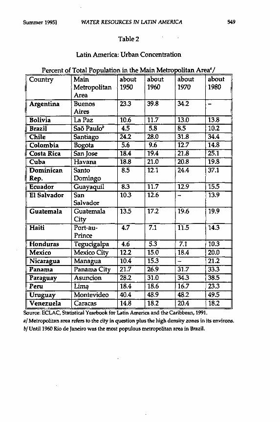
The countries of Latin America are highly centralized, politically,economically and in the distribution of their populations. A high, andincreasing, proportion of the population lives in the principal metropolitanarea in many countries (see Table 2). The Latin American DemographicCenter estimates that by the year 2000 some 22.5 percent of the totalpopulation of the region will live in the 12 largest metropolitan areas.2 Inthe late sixties, the northern border provinces of Argentina accounted forless than two percent of economic output and five percent of the popula-tion.' The provinces within the Rio de la Plata basin in Bolivia onlyaccounted for two percent of output in the same period., There is noreason to suspect that the distribution has changed significantly since then.
20. United Nations, Economic Commission for Latin America and the Caribbean,Changing Production Patterns with Social Equity, Santiago, 1990.
21. United Nations, Latin American Demographic Center, Latin America: percentageurban, 1990, Demographic Bulletin NQ24 (1991).
22. Id.23. Id.
[Vol. 35
Summer 1995] WATER RESOURCES IN LATIN AMERICA
Table 2
Latin America: Urban Concentration
Percent of Total Population in the Main Metro litan Areaa/Country Main about about about about
Metropolitan 1950 1960 1970 1980Area
Argentina Buenos 23.3 39.8 34.2 -Aires
Bolivia La Paz 10.6 11.7 13.0 13.8Brazil Sa6 Paulo' 4.5 5.8 8.5 10.2Chile Santiago 24.2 28.0 31.8 34.4Colombia Bogota 5.6 9.6 12.7 14.8Costa Rica San Jose 18.4 19.4 21.8 25.1Cuba Havana 18.8 21.0 20.8 19.8Dominican Santo 8.5 12.1 24.4 37.1Rep. DomingoEcuador Guayaquil 8.3 11.7 12.9 15.5El Salvador San 10.3 12.6 - 13.9
SalvadorGuatemala Guatemala 13.5 17.2 19.6 19.9
cityI
Haiti Port-au- 4.7 7.1 11.5 14.3Prince
Honduras Tegucigalpa 4.6 5.3 7.1 10.3Mexico Mexico City 12.2 15.0 18.4 20.0Nicaragua Managua 10.4 15.3 - 21.2Panama Panama City 21.7 26.9 31.7 33.3Paraguay Asuncion 28.2 31.0 34.3 38.5Peru Lim1 18.4 18.6 16.7 23.3Uruguay Montevideo 40.4 48.9 48.2 49.5Venezuela Caracas 14.8 18.2 20.4 18.2
Source: ECLAC, Statistical Yearbook for Latin America and the Caribbean, 1991.a/ Metropolitan area refers to the city in question plus the high density zones in its environs.b/Until 1960 Rio de Janeiro was the most populous metropolitan area in Brazil.
NATURAL RESOURCES JOURNAL
It is therefore not surprising to find that the border areas of mostcountries play only a limited role in the economy or in other aspects ofnational society. Shared water resources are by their location and generalsocial significance both economically and politically marginal. Given themarginal economic significance of border regions, the political attentiongiven to managing shared water resources by Latin American governmentshas been sporadic at best. Only when there has been a specific need to giveattention, as in the example of the River Lauca, have governments bestirredthemselves to establish institutional arrangements. Once the issue is past,again as in the case of the Lauca, the institutions fall into disuse, even whenone of the governments remains aggrieved.
Only the institutions established to manage joint capital invest-ments as at Salto Grande and Itaipd have been able to become a permanentpart of the governmental system. Even in these two examples, thepermanent responsibilities of the bilateral institutions have been restrictedto managing the joint production of electricity. In the case of Salto Grande,the original intention had been to give wider authority over environmentalmanagement and regional development. During the construction phase ofits operations, the Joint Argentine-Uruguayan Commission for theconstruction and operation of the Salto Grande dam and generating stationon the River Uruguay developed a major program for environmentalmanagement and regional development. The program included hun-dreds of individual studies in more than 18 areas including climatology,wildlife, agriculture, environmental health, transport and land useplanning.' The program, however, has withered away since the dam andgenerating facilities were completed in 1982.
Mexico-United States of America
These arguments are supported by the exception; the one exampleof active management of shared water resources in Latin America is theMexico-United States of America border rivers. International institutionshave existed for the management of water resource issues since 1853.26From its creation in 1889, both governments have given the InternationalBoundary Commission (now the International Boundary and Water
24. Comisi6n T&dnica Mixta de Salto Grande, Desarrollo Ambiental y Regional en elproyecto Salto Grande (1979) (paper presented at the II Seminario Interamericano deHidroelectricidad, Concordia, Argentina).
25. Gilberto Gallopin et al. The Environmental Dimension in Water Management: the Case ofthe Dam at Salto Grande, 2 J. Water Supply & Mgmt. (1980).
26. David J. Eaton & David Hurlbut, Challenges in the Binational Management of WaterResources in the Rio Grande/Rio Bravo, Lyndon B. Johnson School of Public Affairs, TheUniversity of Texas at Austin, U.S.-Mexican Policy Report No.2 (1992).
[Vol. 35
WATER RESOURCES IN LATIN AMERICA
Commission) increasing jurisdiction over frontier rivers.27 In 1944, theCommission's functions were amplified to cover the resolution of boundarywater and sanitation problems including studies of projects for hydroelec-tric generation plants, storage dams and flood control. The Commission'swork has been an undeniable success in many areas. 2
The Mexican-United States border is a center of economic activityof importance to both countries. The Mexican states along the frontier withthe United States accounted for 25 percent of income from manufacturingin 1989.21 It is an area which is increasingly being integrated into theeconomy of the United States and the most important region in Mexico forthe location of maquila factories.' It has been described as one of the twomost important border regions of the world in terms of economic andurban growth.31
The border is a region of relatively scarce water resources. Forexample the rainfall in the River Bravo (Rio Grande) basin varies from350mm. at Chihuahua to 611mm. at Monterey.32 The climate is equallyarid in the other border basins and on both sides of the border. However,it is the economic and, therefore, political importance of this border region,rather than its climate, which distinguishes it from the other shared waterresources in Latin America.
CONCLUSION
The countries of Latin America adopted the "Declaration onIndustrial and Agricultural Use of International Rivers" at the Seventh
27. David J. Eaton and David Hurlbut, Challenges in the Binational Management of WaterResources in the Rio Grande/ Rio Bravo, US-Mexican Studies Program, Policy Report NQ2, (1992).
28. "By the late 1970s, the Commission has apparently led the two neighbors to settle allmajor surface water allocation and distribution problems, through the adoption of anincredible number of agreements." Alberto Szekely, How to Accomodate an Uncertain Futureinto Institutional Responsiveness and Planning: The Case of Mexico and the United States, 33 Nat.Resources J. 587 (1993).
29. Mexico, Instituto Nacional de Estadistica, Geograffa e Informatica, XII CensoIndustrial, 1989, Mexico (1992)
30. The number of maquiladora plants in Mexico grew from 120 in 1970 to 1396 in 1988;although not all of these are located in the border states, Tijuana and Ciudad Juarez havethe largest concentrations. Robert B. South, Transnational "Maquiladora" Location , Annals ofthe Association of American Geographers, Vol.80, No. 4, December, 1990.
31. Lawrence A. Hersog, International Boundary Cities: The Debate on Transfrontier Planningin Two Border Regions, 31 Nat. Resources J. (1991)
32. United Nations, Economic Commission for Latin America and the Caribbean, LatinAmerica and the Caribbean: Inventory of Water Resources and their Utilization, Volume I,Mexico, Central America and the Caribbean, U. N. Document LC/G.1563/Rev.1 (1990).
Summer 1995]
NATURAL RESOURCES JOURNAL
Inter-American Conference at Montevideo in 1933.1 The Declaration didnot lead to the adoption of a formal convention, although it has been usedto support government actions affecting shared water resources. TheDeclaration emphasized the principle of reasonable use to avoid sensibledamage to the other party in the case of both frontier rivers and of riversflowing successively from one state to another.' In general, the countrieshave respected this principle in developing shared basin water resources.In almost all cases, any development, however, has been undertakenthrough individual projects.
It can be claimed that the Declaration has been respected, despitethe disagreements between Brazil and Argentina in the 1970s over thesystem established under the Rio de la Plata Basin Treaty for the harmoni-ous development and physical integration of the Plata basin.' Much of thediscussion of the situation in the Plata is based on the double assumptionthat, first, some form of active international institution for the managementof the river basin as a hydrologic unit was necessary and, second, that itwas intended by the governments which negotiated the treaty. 6 Thereseems to be no proof that this was the case. The treaty specifically states inArticle V that collective action should not interfere with projects developednationally.'
Although the development of hydroelectric power generation inthe Plata Basin has been extensive over the last two decades, the basin itselfhas not been central to the economic development of the economies of thecountries sharing the basin nor have the hydroelectric schemes beenmultinational, with the significant exceptions of Itaipu, Salto Grande andYacereta.?
It would seem, therefore, that the reasons for the failure to developstrong international institutions for the management of shared waterresources do not lie in political rivalries or in logical analyses by govern-ments of the risks of integration. The failure lies, rather, in the marginalsignificance of the shared water resources to most Latin Americaneconomies.
History clearly shows that issues related to the management anduse of shared water resources only become of significance when there is
33. Organization of American States, supra note 10, at 111.34. Id.35. See the discussion in Barberis supra note 10.36. See the two articles by Cano supra notes 5 and 13 and the discussion in J. 0. Trevin
& J.C. Day, Risk Perception in International River Basin Management: The Plata Basin Example,30 Nat. Resources Jour., 87 (1990).
37. Organization of American States, supra note 8 at 169.38. The Amazon and the Orinoco and the boundary rivers that form the majority of the
shared water resources of Latin America have been of considerably less economicimportance.
[Vol. 35
WATER RESOURCES IN LATIN AMERICA
either a specific dispute or when there is a development project of mutualbenefit. There have been no general issues of shared water resourcemanagement that have excited interest or provoked action on any riverexcept on those shared by the United States and Mexico.
The move towards greater economic integration among thecountries of the region which resulted in the formation of the SouthernCommon Market (Mercosur) may result in a revival of interest in themanagement of shared water resources. The assignment of tasks (includinga study of the institutional infrastructure of the Rio de la Plata Treaty) bythe Mercosur to the Intergovernmental Coordinating Committee for thePlata Basin is one example. There is also a recent initiative, supported bythe United Nations, for joint management by Colombia and Venezuela ofthe shared resources within the Orinoco river basin.
Despite the moves within the region towards greater economicintegration, it is not certain that the relative importance of shared waterresources has changed in any significant way. They remain marginal to themain focus of development for most of the countries of the region. Unlessthis situation changes radically, it can be expected that the management ofshared water resources in Latin America will continue to figure only inrhetorical expressions of political intent.
Summer 19951