Embed Size (px)
Citation preview
THE MAXXI MUSEUM IN ROME: AN INTEGRATED SURVEY EXPERIENCE FOR
THE RESTORATION OF CONTEMPORARY ARCHITECTURE
A. Versaci a, A. Cardaci b
a Faculty of Engineering and Architecture, University of Enna Kore, Cittadella Universitaria, Enna - [email protected] b School of Engineering, University of Bergamo, Viale Marconi 5, Dalmine - [email protected]
Commission VI, WG VI/4
KEY WORDS: Contemporary architecture, reinforced concrete, conservation, 3D laser scanning
ABSTRACT:
In recent years, the fate of contemporary buildings in reinforced concrete is becoming a growing concern due to the fast ageing of
structures, however, often of great architectural and social interest. The procedures to put in place for their material and structural
preservation require multidisciplinary expertise, but also new methodological insights as most of these edifices are the result of
pioneering experiments and individual ‘challenges’ from the morphological and technical point of views. They strictly depend on both
the recognition of their peculiarities and the ability to differentiate their intrinsic characteristics of inhomogeneity from insecurity
factors and degradation phenomena. This paper focuses on the experience undertaken on the MAXXI, the National Museum of the 21st
century Arts, built by Zaha Hadid Architects in Rome to highlight the methodological process followed for the knowledge of this
architectural work, in view of the establishment of the project for its conservation.
1. INTRODUCTION
The MAXXI - the National Museum of the 21st century Arts, built
by Zaha Hadid Architects in Rome - is an architectural icon that
is representative of our time, but is, in particular, a work that is
the fruit of a technical-constructive complexity, which
necessitated the putting in place of specific and very articulate
realization procedures.
The structure was strongly supported by the (at the time) Ministry
for Cultural Heritage. Its erection would have been the answer to
the already long manifested demand to create an Italian public
museum to gather inside, the greatest testimonies of
contemporary creativity in the fields of art and architecture. For
its construction, it was then chosen a flat area located within the
Flaminio district - bounded on one side by the Tiber River and
on the other side by the historical via Flaminia - and occupied by
army barracks and military buildings. The construction yard -
perhaps one of the most innovative in the world - was then
entrusted to the Ministry of Infrastructure that followed it from
2003 - the laying of the first stone’s year - to 2009, so achieving
a difficult challenge that asked for a great financial effort and
hard decision-making processes.
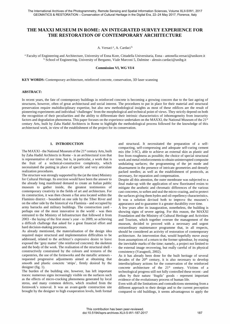
As already mentioned, the materialisation of the design idea
required major structural and implementation difficulties to be
addressed, related to the architect’s expressive desire to leave
exposed the ‘grey matter’ (the reinforced concrete): the skeleton
and the body of the work. The realisation of the structural shell -
constructively constrained by the colours and textures of the
carpentries, the use of the formworks and the metallic armours -
requested progressive adjustments aimed at obtaining that
smooth and plastic concrete ‘strips’, firmly desired by the
designer (fig. 1).
The burden of the building site, however, has left important
traces: numerous signs increasingly visible on the surfaces such
as the effects of micro-cracking phenomena generated by local
stress, and many common defects, which resulted from the
formwork’s removal. It was an avant-garde construction site
brought by the designer to high exasperation levels, both formal
and structural. It necessitated the preparation of a self-
compacting, self-compressing and adequate self-curing cement
mix (the 3-SC), able to achieve an external skin as plastic and
free from roughness as possible; the choice of special structural
work and metal reinforcements to obtain uninterrupted composite
undulating surfaces; the programming of the jet mode and
disarmament in the presence of intricate geometries and densely
packed needles; as well as the establishment of protocols, as
necessary, for reparation and compensation.
Despite all this attention, the outer membrane was subjected to a
final make-up with the application of new fluorinated resins to
mitigate the aesthetic and chromatic differences of the various
cast concretes, to soften and seal the micro-crazing, and to protect
the surfaces giving them hydro and oil-repellency characteristics.
It was a solution devised both to improve the museum’s
appearance and to guarantee it a greater durability over time.
A few years after its inauguration, nonetheless, the building is
showing signs of severe ageing. For this reason, the MAXXI
Foundation and the Ministry of Cultural Heritage and Activities
and Tourism, which together oversee the management of the
museum, decided to proceed with a necessary and urgent
extraordinary maintenance programme that, in all respects,
should be considered an activity of restoration of contemporary
architecture. An intervention that, would hopefully move away
from assumptions of a return to the former splendour, by erasing
the inevitable marks of the time; namely, a project not limited to
the external image recovering, but really careful of its physical
consistency (Varagnoli, 2002).
As it has already been done for the built heritage of several
decades of the 20th century, it is also necessary to develop
interdisciplinary actions for the conservation of the reinforced
concrete architecture of the 21st century. Victims of a
technological progress still not fully controlled these recent - and
often by their nature ‘fragile’ goods - represent important
evidence of the evolutionary process of human life.
Even with all the limitations and contradictions stemming from a
different approach to their design and to the current perception
compared to old buildings, it seems advantageous to apply the
The International Archives of the Photogrammetry, Remote Sensing and Spatial Information Sciences, Volume XLII-5/W1, 2017 GEOMATICS & RESTORATION – Conservation of Cultural Heritage in the Digital Era, 22–24 May 2017, Florence, Italy
This contribution has been peer-reviewed. doi:10.5194/isprs-archives-XLII-5-W1-187-2017 187
methodology already discussed and established for the
preservation of historical heritage also to these works, to promote
their permanence and ensure the preservation of their identities
and the numerous values embodied in them.
It also appears necessary to improve a reflection on the meanings
of the works and on the traces, that insist on them. Traces that are
not necessarily due to an intention of the designer, but rather
often the result of an inevitable sedimentation of the buildings in
time and space, which as such are to be respected (Vassallo,
2004). This, within a restoration project that will not be restricted
to the simple - though indispensable - understanding of the
architectures, but which will become a critical, creative process,
disengaged from the inopportune dispute between refurbishment
and conservation that has until now dominated the restoration of
modern architecture.
2. PRELIMINARY STUDIES FOR THE
CONSERVATION OF CONTEMPORARY ‘GREY
MATTER’
Already interested by a phase of preliminary works that have
been a place of metamorphosis, a very moment of creativity and
great mediation between the matter and the form, among the
structure and the architecture - essential aspects latent in the
figurative program of the project - the building was involved over
time in numerous repairs and improving treatments that were,
unfortunately, not properly documented.
The drawings submitted by the Hadid agency represent the final
design, but they not fully express the hard job of characterization,
layering and improvement that was undertaken.
The above-mentioned management institutions, making use of
external professional and academic consultants - among them,
the authors of this paper -, have therefore initiated specific
knowledge-building activities through the identification and
mapping of degradation and alteration phenomena.
This task was initiated by specific metric-formal investigations
and critical detection through 3D laser scanning techniques and
image-based 3D modelling to both obtain virtual and solid
representations useful to verify the compliance of the built
architecture with the design drawings, and at the same time to
generate photorealistic and orthorectified supports on which to
represent the decay mapping.
Founded on the methodological and operative apparatus of the
conservation discipline, the study initially required an approach
to the fluid volumes that characterise the MAXXI based on
‘traditional’ built reading imperatives: bibliographic and archival
research, collection and critical analysis of all documentation
(drawings, photographs, sketches, notes), and direct observation.
This analysis was integrated with a survey conducted in
accordance with innovative methods and technologies, which
were not though managed in an ‘automatic’ way, but rather were
properly ‘controlled’ by the operators and made sensitive to the
demands dictated by the purpose of the work.
It was a survey specifically conceived for the conservation
project that has left no handle or bend from the machines, but
which has sought to benefit from the evident advantages of
technological progress to improve the understanding of the
artefact - not only for measuring it - so amplifying its perception
through visions and viewpoints otherwise impossible to obtain
(Fiorani, 2013). This in the awareness that no amount of progress
will ever allow technology to detect the very essence of a
monument if the activity is not guided by the sensitivity and
culture of specialists able to analyse the architecture.
The architectural survey is both an instrument devoted to the
understanding of the built object in its technical and
morphological components and an investigation tool able to
deeply check the talent of the designer in ‘creating architecture’.
If according to Franco Purini, the drawing is the way the architect
communicates - through graphics signs - the space that lives
within its mind before the work is done (Purini, 1996), the survey
allows verifying the correspondence between the project idea and
the built reality.
The construction times, during which the dreams of the designer
should be translated into structures and building partitions, often
cause a break between the imaginary assumptions and the actual
implementation, especially when the building is a multifaceted
and innovative structure.
This was not the case for the MAXXI Museum. The critical
analysis of the structure - conducted from iconographic material
available in the archives of the Foundation - has shown the
perfect correspondence between the working drawings and the
as-built, so highlighting the accomplished concretization of the
designer’s will.
The building site has gradually given corporeality to the bold and
innovative idea of Zaha Hadid. She stated in an interview how
excited she was when visited it and saw how the edifice was quite
emerging from the ground and how lines began to cross, as she
wanted, allowing to perceive the impact that it would have in the
space (RaiStoria, 2011).
Figure 1. The MAXXI, the National Museum of the 21st Century Arts, today
The International Archives of the Photogrammetry, Remote Sensing and Spatial Information Sciences, Volume XLII-5/W1, 2017 GEOMATICS & RESTORATION – Conservation of Cultural Heritage in the Digital Era, 22–24 May 2017, Florence, Italy
This contribution has been peer-reviewed. doi:10.5194/isprs-archives-XLII-5-W1-187-2017
188
The correspondence between the survey’s results and working
drawings is amazing (differences are of the order of a few
centimetres). It is the tangible proof of a careful and timely action
in the activity carried out by the site management, as well as of a
great sensitivity and designing intelligence into thinking the
architectural work in its final forms.
The same attention can be found in the drawings (plans and
elevations) where the holes of the formwork’s connecting
elements are represented by circular and/or oval shapes
(obviously out of scale and emphasised), to indicate the septa’s
inclination.
Even working production information, often employ
dimensioning rules more consistent to the mechanical than to
architectural design, with an extensive use of constructive
assembly drawings and clear references to strict construction
protocols (Ippolito, 2016).
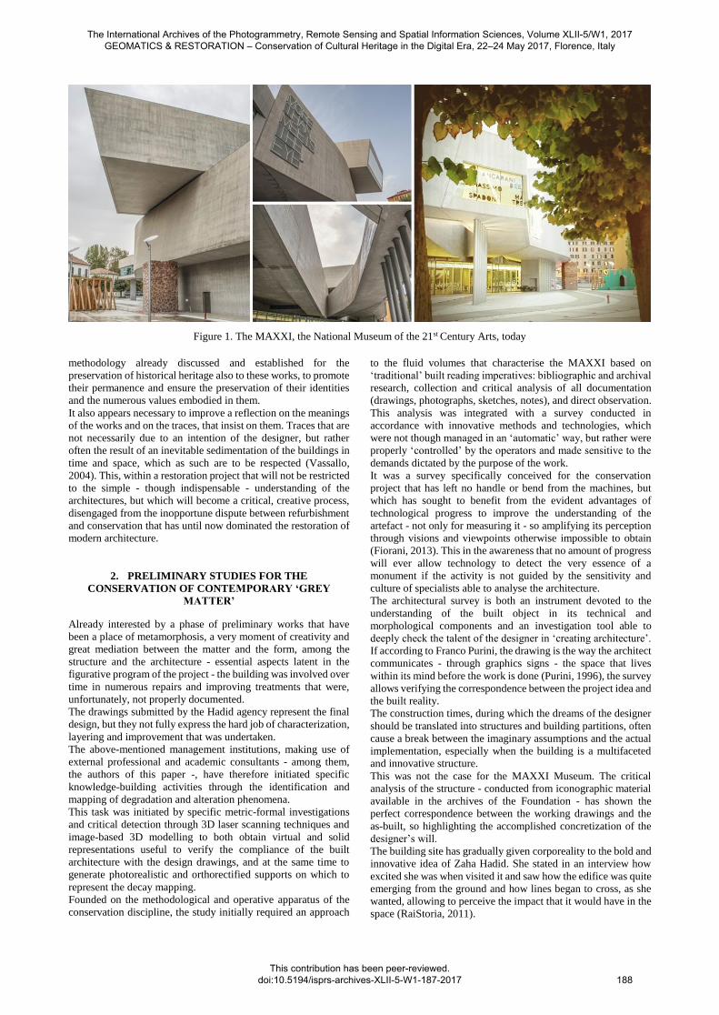
Surveys undertaken have caught all these aspects. Never driven
by an obsession for millimetre precision, the acquisition
campaigns by active sensors were conducted in a painstaking
manner, performing a hundred stations to ensure the necessary
accuracy but above all to fully control the activity (fig. 2).
For costs saving and a faster measuring execution time, it has
been preferred not to resort to the ‘classical’ topographic support
network, but to opt for a considerable number of acquisitions,
with large overlapping areas (never less than 40%). This enabled
the obtaining of a dense points cloud - composed of over
50,000,000 points with an average distance of 1-2 cm and a mean
error in scans recording less than the required tolerance value for
the 1:50 scale (± 1.5 cm) - and, therefore, a reliable
documentation of existing condition (fig. 3).
The 3D laser surveying has been matched with a photographic
survey, carried out in the most suitable natural lighting
conditions, avoiding situations of sharp contrast, and in the hours
of the day when the colour temperature could be considered
reasonably constant. Each campaign was preceded by the
calibration of the camera through the Xrite Colorchecker system,
which, although not a strict colorimetric measuring system, has
allowed a good match between the real colours and captured
images (Cardaci, Versaci, 2012).
The more than fifteen hundred chromatically calibrated
photographic shots were also performed in perpendicular
directions to the surfaces, with an overlap between two
successive snapshots of 40-60%.
The processing of information resulting from acquisitions made
with different techniques - a delicate praxis still subject to large
experimentation - was conducted based on a surveying approach
strictly targeted to the specificity of the architecture and
boundary settings. It has been finalised, per a precise choice of
the working team, to produce a final model combining the
accuracy offered by 3D laser scanning and the high descriptive
quality of 3D image-based modelling: an essential condition for
the effective representation of degradation phenomena.
Such a mediation as well as the direct survey reflections have
enriched the knowledge and facilitated the understanding not
always ‘possible’ by a model produced in an automatic way. For
the reconstruction of a single model, the clouds were so first
filtered and pre-aligned by the creation of separate workflows
(seven in total corresponding to the scanning campaigns).
Subsequently, they have been joined together within a single
reference system by means of a shape control algorithm.
The result provided the absolute coordinates of significant points
(Ground Control Points), used in the creation of virtual models
with 3D software image-based reconstruction.
The photogrammetric model was constructed from the raw
images. The digital negatives - collected in homogeneous groups
- have been developed in Camera Raw by adjusting, each time,
the exposure, the high and low lights, the vividness and the colour
saturation. It was, in fact, necessary to standardize all the shots to
eliminate any differences and/or too high contrasts. The corrected
images were then saved in .tiff files and imported to Structure-
from-Motion software system tools.
The procedure of 3D model construction comprised four main
stages: the photographs alignment, the point cloud building
(sparse and dense), the creation of polygon mesh, and then,
finally, the model was textured by using the original photos. For
a more successful estimation of the information on lens focal
values and distortions, the camera was calibrated manually. The
relative distances of the ground control points have allowed
scaling, orientating, and verifying the quality of the textured
model, from which hyposcopic views and orthographic
projections were derived, also with a view to elaborating reliable
bill of quantity estimates.
Figure 2. Architectural survey by 3D laser scanning
The International Archives of the Photogrammetry, Remote Sensing and Spatial Information Sciences, Volume XLII-5/W1, 2017 GEOMATICS & RESTORATION – Conservation of Cultural Heritage in the Digital Era, 22–24 May 2017, Florence, Italy
This contribution has been peer-reviewed. doi:10.5194/isprs-archives-XLII-5-W1-187-2017
189
3. METHODS OF ANALYSIS AND REPRESENTATION
OF CONCRETE SURFACES FOR CONSERVATION
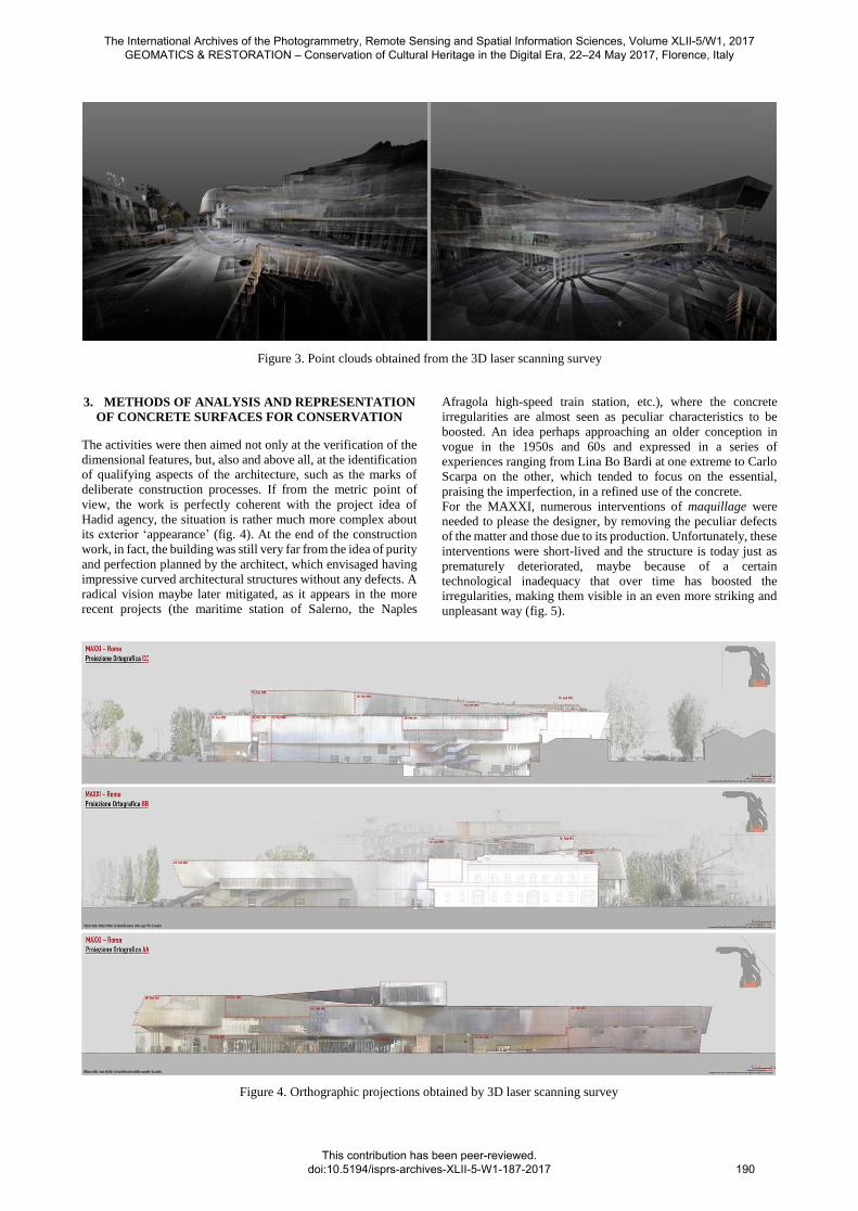
The activities were then aimed not only at the verification of the
dimensional features, but, also and above all, at the identification
of qualifying aspects of the architecture, such as the marks of
deliberate construction processes. If from the metric point of
view, the work is perfectly coherent with the project idea of
Hadid agency, the situation is rather much more complex about
its exterior ‘appearance’ (fig. 4). At the end of the construction
work, in fact, the building was still very far from the idea of purity
and perfection planned by the architect, which envisaged having
impressive curved architectural structures without any defects. A
radical vision maybe later mitigated, as it appears in the more
recent projects (the maritime station of Salerno, the Naples
Afragola high-speed train station, etc.), where the concrete
irregularities are almost seen as peculiar characteristics to be
boosted. An idea perhaps approaching an older conception in
vogue in the 1950s and 60s and expressed in a series of
experiences ranging from Lina Bo Bardi at one extreme to Carlo
Scarpa on the other, which tended to focus on the essential,
praising the imperfection, in a refined use of the concrete.
For the MAXXI, numerous interventions of maquillage were
needed to please the designer, by removing the peculiar defects
of the matter and those due to its production. Unfortunately, these
interventions were short-lived and the structure is today just as
prematurely deteriorated, maybe because of a certain
technological inadequacy that over time has boosted the
irregularities, making them visible in an even more striking and
unpleasant way (fig. 5).
Figure 3. Point clouds obtained from the 3D laser scanning survey
Figure 4. Orthographic projections obtained by 3D laser scanning survey
The International Archives of the Photogrammetry, Remote Sensing and Spatial Information Sciences, Volume XLII-5/W1, 2017 GEOMATICS & RESTORATION – Conservation of Cultural Heritage in the Digital Era, 22–24 May 2017, Florence, Italy
This contribution has been peer-reviewed. doi:10.5194/isprs-archives-XLII-5-W1-187-2017
190
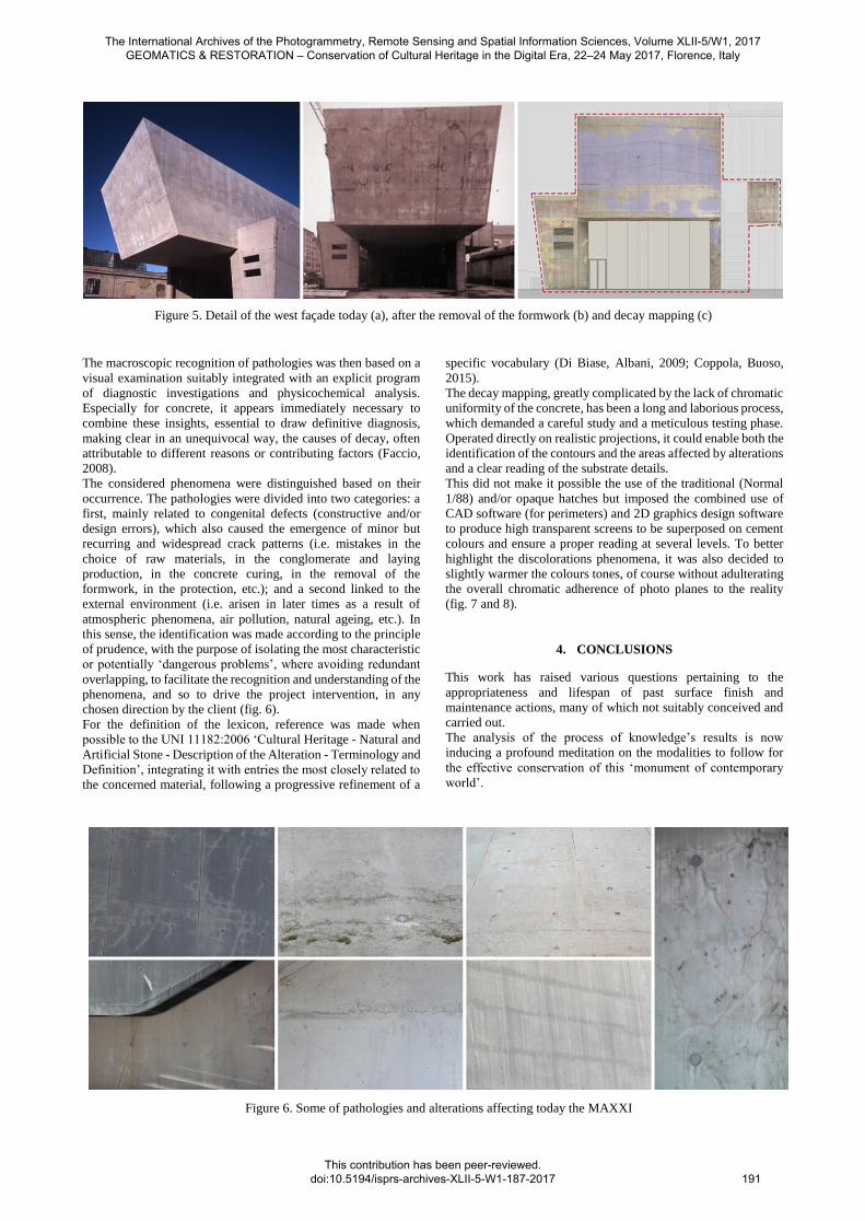
The macroscopic recognition of pathologies was then based on a
visual examination suitably integrated with an explicit program
of diagnostic investigations and physicochemical analysis.
Especially for concrete, it appears immediately necessary to
combine these insights, essential to draw definitive diagnosis,
making clear in an unequivocal way, the causes of decay, often
attributable to different reasons or contributing factors (Faccio,
2008).
The considered phenomena were distinguished based on their
occurrence. The pathologies were divided into two categories: a
first, mainly related to congenital defects (constructive and/or
design errors), which also caused the emergence of minor but
recurring and widespread crack patterns (i.e. mistakes in the
choice of raw materials, in the conglomerate and laying
production, in the concrete curing, in the removal of the
formwork, in the protection, etc.); and a second linked to the
external environment (i.e. arisen in later times as a result of
atmospheric phenomena, air pollution, natural ageing, etc.). In
this sense, the identification was made according to the principle
of prudence, with the purpose of isolating the most characteristic
or potentially ‘dangerous problems’, where avoiding redundant
overlapping, to facilitate the recognition and understanding of the
phenomena, and so to drive the project intervention, in any
chosen direction by the client (fig. 6).
For the definition of the lexicon, reference was made when
possible to the UNI 11182:2006 ‘Cultural Heritage - Natural and
Artificial Stone - Description of the Alteration - Terminology and
Definition’, integrating it with entries the most closely related to
the concerned material, following a progressive refinement of a
specific vocabulary (Di Biase, Albani, 2009; Coppola, Buoso,
2015).
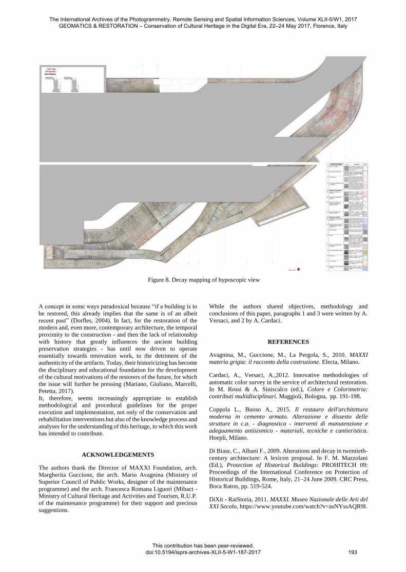
The decay mapping, greatly complicated by the lack of chromatic
uniformity of the concrete, has been a long and laborious process,
which demanded a careful study and a meticulous testing phase.
Operated directly on realistic projections, it could enable both the
identification of the contours and the areas affected by alterations
and a clear reading of the substrate details.
This did not make it possible the use of the traditional (Normal
1/88) and/or opaque hatches but imposed the combined use of
CAD software (for perimeters) and 2D graphics design software
to produce high transparent screens to be superposed on cement
colours and ensure a proper reading at several levels. To better
highlight the discolorations phenomena, it was also decided to
slightly warmer the colours tones, of course without adulterating
the overall chromatic adherence of photo planes to the reality
(fig. 7 and 8).
4. CONCLUSIONS
This work has raised various questions pertaining to the
appropriateness and lifespan of past surface finish and
maintenance actions, many of which not suitably conceived and
carried out.
The analysis of the process of knowledge’s results is now
inducing a profound meditation on the modalities to follow for
the effective conservation of this ‘monument of contemporary
world’.
Figure 5. Detail of the west façade today (a), after the removal of the formwork (b) and decay mapping (c)
Figure 6. Some of pathologies and alterations affecting today the MAXXI
The International Archives of the Photogrammetry, Remote Sensing and Spatial Information Sciences, Volume XLII-5/W1, 2017 GEOMATICS & RESTORATION – Conservation of Cultural Heritage in the Digital Era, 22–24 May 2017, Florence, Italy
This contribution has been peer-reviewed. doi:10.5194/isprs-archives-XLII-5-W1-187-2017
191
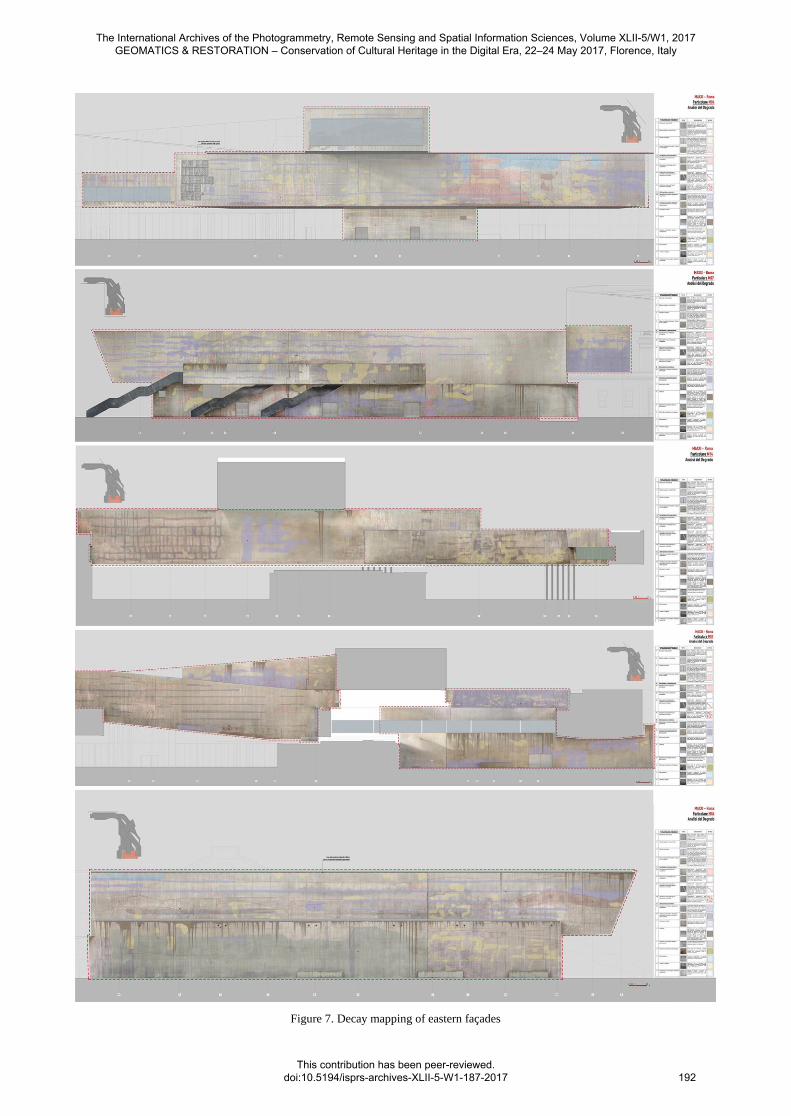
Figure 7. Decay mapping of eastern façades
The International Archives of the Photogrammetry, Remote Sensing and Spatial Information Sciences, Volume XLII-5/W1, 2017 GEOMATICS & RESTORATION – Conservation of Cultural Heritage in the Digital Era, 22–24 May 2017, Florence, Italy
This contribution has been peer-reviewed. doi:10.5194/isprs-archives-XLII-5-W1-187-2017
192
A concept in some ways paradoxical because “if a building is to
be restored, this already implies that the same is of an albeit
recent past” (Dorfles, 2004). In fact, for the restoration of the
modern and, even more, contemporary architecture, the temporal
proximity to the construction - and then the lack of relationship
with history that greatly influences the ancient building
preservation strategies - has until now driven to operate
essentially towards renovation work, to the detriment of the
authenticity of the artifacts. Today, their historicizing has become
the disciplinary and educational foundation for the development
of the cultural motivations of the restorers of the future, for which
the issue will further be pressing (Mariano, Giuliano, Marcelli,
Petetta, 2017).
It, therefore, seems increasingly appropriate to establish
methodological and procedural guidelines for the proper
execution and implementation, not only of the conservation and
rehabilitation interventions but also of the knowledge process and
analyses for the understanding of this heritage, to which this work
has intended to contribute.
ACKNOWLEDGEMENTS
The authors thank the Director of MAXXI Foundation, arch.
Margherita Guccione, the arch. Mario Avagnina (Ministry of
Superior Council of Public Works, designer of the maintenance
programme) and the arch. Francesca Romana Liguori (Mibact -
Ministry of Cultural Heritage and Activities and Tourism, R.U.P.
of the maintenance programme) for their support and precious
suggestions.
While the authors shared objectives, methodology and
conclusions of this paper, paragraphs 1 and 3 were written by A.
Versaci, and 2 by A. Cardaci.
REFERENCES
Avagnina, M., Guccione, M., La Pergola, S., 2010. MAXXI
materia grigia: il racconto della costruzione. Electa, Milano.
Cardaci, A., Versaci, A.,2012. Innovative methodologies of
automatic color survey in the service of architectural restoration.
In M. Rossi & A. Siniscalco (ed.), Colore e Colorimetria:
contributi multidisciplinari. Maggioli, Bologna, pp. 191-198.
Coppola L., Buoso A., 2015. Il restauro dell'architettura
moderna in cemento armato. Alterazione e dissesto delle
strutture in c.a. - diagnostica - interventi di manutenzione e
adeguamento antisismico - materiali, tecniche e cantieristica.
Hoepli, Milano.
Di Biase, C., Albani F., 2009. Alterations and decay in twentieth-
century architecture: A lexicon proposal. In F. M. Mazzolani
(Ed.), Protection of Historical Buildings: PROHITECH 09:
Proceedings of the International Conference on Protection of
Historical Buildings, Rome, Italy, 21–24 June 2009. CRC Press,
Boca Raton, pp. 519-524.
DiXit - RaiStoria, 2011. MAXXI. Museo Nazionale delle Arti del
XXI Secolo, https://www.youtube.com/watch?v=asNYssAQR9I.
Figure 8. Decay mapping of hyposcopic view
The International Archives of the Photogrammetry, Remote Sensing and Spatial Information Sciences, Volume XLII-5/W1, 2017 GEOMATICS & RESTORATION – Conservation of Cultural Heritage in the Digital Era, 22–24 May 2017, Florence, Italy
This contribution has been peer-reviewed. doi:10.5194/isprs-archives-XLII-5-W1-187-2017 193
Dorfles, F., 2004. Il restauro del Moderno rispetto all’Antico,
Arte/Architettura/Ambiente, V (8), pp. 9-10.
Faccio, P., 2008. Il calcestruzzo storico: conservazione o
ripristino?. In R. Ientile (ed.), Architetture in cemento armato.
Orientamenti per la conservazione, Franco Angeli, Milano, pp.
198-204.
Fiorani, D., 2013. Il lato tecnico del restauro: opportunità, limiti
e contenuti. In S. Musso (ed.), Nuove tecniche di restauro
architettonico, Wolters Kluver Italia. Milano, pp. 33-60.
Ippolito, A., 2016. Handbook of Research on Emerging
Technologies for Architectural and Archaeological Heritage. IGI
Global, Hershey USA.
Mariano F., Giuliano, A. A., Marcelli F. & Petetta, L., 2017.
Restauro e conservazione dell’architettura del Novecento:
l’esperienza dell’edilizia italiana tra gli anni Venti e Sessanta.
Piani conoscitivi, strumenti operativi e sviluppi didattici. In D.
Fiorani (Ed.), RICerca/REStauro, Quasar, Roma, pp. 448-457.
Purini, F., 1996. Una lezione sul disegno. Gangemi, Roma.
Varagnoli, C., 2002. Gli eccessi del restauro. Parametro, 239, pp.
68-69.
Vassallo, E., 2004. I segni del tempo. Restauro, Architettura,
architetture. In S. Valtieri, Della Bellezza ne è piena la vista!
Restauro e conservazione alle latitudini del mondo nell'era della
globalizzazione, Atti del Convegno: Verso una filosofia
pluralistica della conservazione per il XXI secolo, (Reggio
Calabria 2003), Nuova Argos, Roma, pp. 158-175.
The International Archives of the Photogrammetry, Remote Sensing and Spatial Information Sciences, Volume XLII-5/W1, 2017 GEOMATICS & RESTORATION – Conservation of Cultural Heritage in the Digital Era, 22–24 May 2017, Florence, Italy
This contribution has been peer-reviewed. doi:10.5194/isprs-archives-XLII-5-W1-187-2017 194