Embed Size (px)
Citation preview
THE PALAEONTOLOGICAL HISTORICAL RESOURCES IMPACT ASSESSMENT OF THE QUANTUMPLACE
DEVELOPMENTS LTD. HARVEST HILLS REDEVELOPMENT RESIDENTIAL SUBDIVISION, CALGARY, AB
NPI Report No. 2015-14
RTMP Permit No. 2015-010 HRA Requirements Project File: 4825-15-0037-001
May 5, 2015
Samuel M. Wilson, MSc, P. Geol, Prof. Palaeontologist (AB) Nautilus Paleontology, Inc.
47 Cortina Villas SW, Calgary, AB T3H 0W8
Catherine Biollo, BSc, G.I.T. 11 Edgeland Mews NW, Calgary, AB T3A 4C9
Table of Contents THE PALAEONTOLOGICAL HISTORICAL RESOURCES IMPACT ASSESSMENT OF THE QUANTUMPLACE DEVELOPMENTS LTD. HARVEST HILLS REDEVELOPMENT RESIDENTIAL SUBDIVISION, CALGARY, AB ............................................................... 1
Introduction ..................................................................................................................... 1
Geology and Paleontology .............................................................................................. 2
Project Area Assessment ................................................................................................ 4
Methodology ................................................................................................................ 4
Field Observations ....................................................................................................... 5
Borehole Data Analysis ............................................................................................... 6
Conclusion and Recommendation* ................................................................................. 8
Report authorization ........................................................................................................ 9
References .................................................................................................................... 10
APPENDIX .................................................................................................................... 12
Schedule A, HRA Requirements File 4825-15-0037-001 .......................................... 12
RTMP Permit to Excavate Palaeontological Resources 2015-010 ............................ 12
Nautilus Paleontology Inc Harvest Hills Redevelopment Page 1 of 12
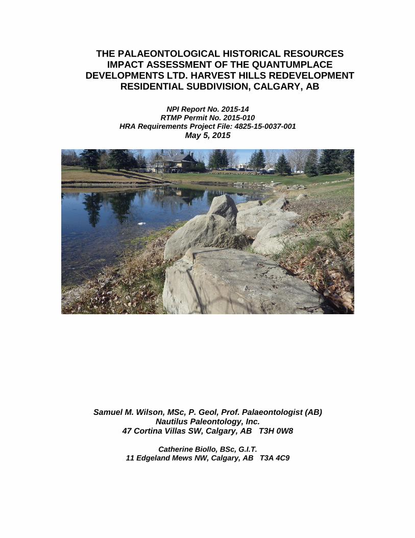
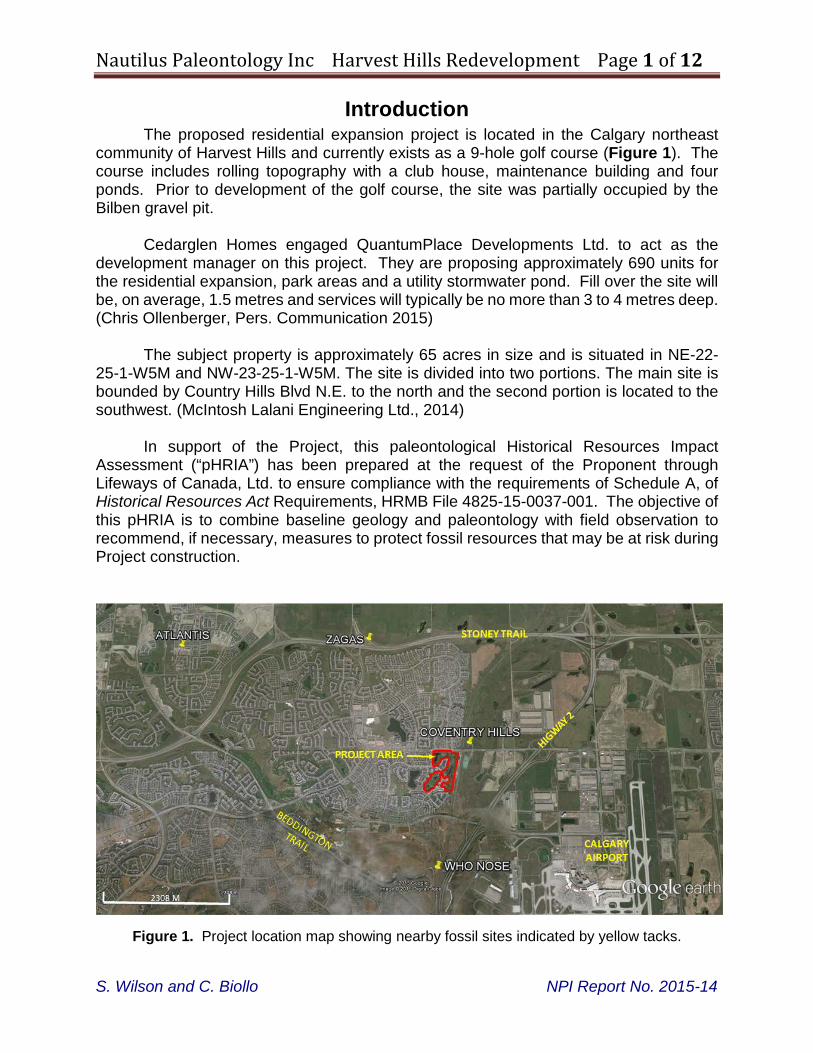
Introduction The proposed residential expansion project is located in the Calgary northeast
community of Harvest Hills and currently exists as a 9-hole golf course (Figure 1). The course includes rolling topography with a club house, maintenance building and four ponds. Prior to development of the golf course, the site was partially occupied by the Bilben gravel pit.
Cedarglen Homes engaged QuantumPlace Developments Ltd. to act as the
development manager on this project. They are proposing approximately 690 units for the residential expansion, park areas and a utility stormwater pond. Fill over the site will be, on average, 1.5 metres and services will typically be no more than 3 to 4 metres deep. (Chris Ollenberger, Pers. Communication 2015)
The subject property is approximately 65 acres in size and is situated in NE-22-
25-1-W5M and NW-23-25-1-W5M. The site is divided into two portions. The main site is bounded by Country Hills Blvd N.E. to the north and the second portion is located to the southwest. (McIntosh Lalani Engineering Ltd., 2014)
In support of the Project, this paleontological Historical Resources Impact
Assessment (“pHRIA”) has been prepared at the request of the Proponent through Lifeways of Canada, Ltd. to ensure compliance with the requirements of Schedule A, of Historical Resources Act Requirements, HRMB File 4825-15-0037-001. The objective of this pHRIA is to combine baseline geology and paleontology with field observation to recommend, if necessary, measures to protect fossil resources that may be at risk during Project construction.
Figure 1. Project location map showing nearby fossil sites indicated by yellow tacks.
S. Wilson and C. Biollo NPI Report No. 2015-14
Nautilus Paleontology Inc Harvest Hills Redevelopment Page 2 of 12
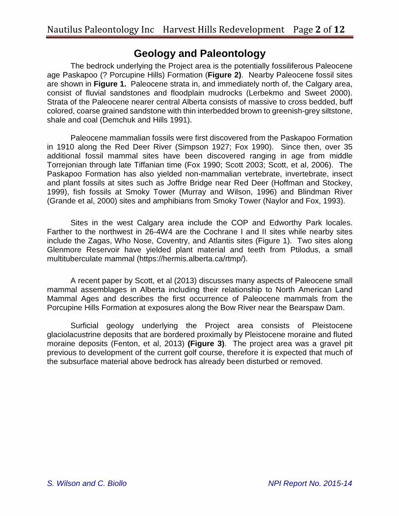
Geology and Paleontology The bedrock underlying the Project area is the potentially fossiliferous Paleocene
age Paskapoo (? Porcupine Hills) Formation (Figure 2). Nearby Paleocene fossil sites are shown in Figure 1. Paleocene strata in, and immediately north of, the Calgary area, consist of fluvial sandstones and floodplain mudrocks (Lerbekmo and Sweet 2000). Strata of the Paleocene nearer central Alberta consists of massive to cross bedded, buff colored, coarse grained sandstone with thin interbedded brown to greenish-grey siltstone, shale and coal (Demchuk and Hills 1991).
Paleocene mammalian fossils were first discovered from the Paskapoo Formation in 1910 along the Red Deer River (Simpson 1927; Fox 1990). Since then, over 35 additional fossil mammal sites have been discovered ranging in age from middle Torrejonian through late Tiffanian time (Fox 1990; Scott 2003; Scott, et al, 2006). The Paskapoo Formation has also yielded non-mammalian vertebrate, invertebrate, insect and plant fossils at sites such as Joffre Bridge near Red Deer (Hoffman and Stockey, 1999), fish fossils at Smoky Tower (Murray and Wilson, 1996) and Blindman River (Grande et al, 2000) sites and amphibians from Smoky Tower (Naylor and Fox, 1993).
Sites in the west Calgary area include the COP and Edworthy Park locales. Farther to the northwest in 26-4W4 are the Cochrane I and II sites while nearby sites include the Zagas, Who Nose, Coventry, and Atlantis sites (Figure 1). Two sites along Glenmore Reservoir have yielded plant material and teeth from Ptilodus, a small multituberculate mammal (https://hermis.alberta.ca/rtmp/).
A recent paper by Scott, et al (2013) discusses many aspects of Paleocene small mammal assemblages in Alberta including their relationship to North American Land Mammal Ages and describes the first occurrence of Paleocene mammals from the Porcupine Hills Formation at exposures along the Bow River near the Bearspaw Dam.
Surficial geology underlying the Project area consists of Pleistocene glaciolacustrine deposits that are bordered proximally by Pleistocene moraine and fluted moraine deposits (Fenton, et al, 2013) (Figure 3). The project area was a gravel pit previous to development of the current golf course, therefore it is expected that much of the subsurface material above bedrock has already been disturbed or removed.
S. Wilson and C. Biollo NPI Report No. 2015-14
Nautilus Paleontology Inc Harvest Hills Redevelopment Page 3 of 12
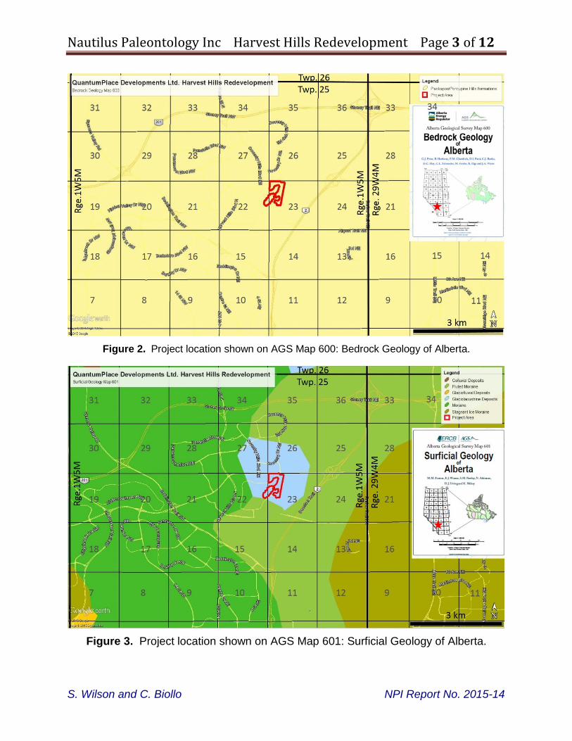
Figure 2. Project location shown on AGS Map 600: Bedrock Geology of Alberta.
Figure 3. Project location shown on AGS Map 601: Surficial Geology of Alberta.
S. Wilson and C. Biollo NPI Report No. 2015-14
Nautilus Paleontology Inc Harvest Hills Redevelopment Page 4 of 12
Project Area Assessment
Methodology
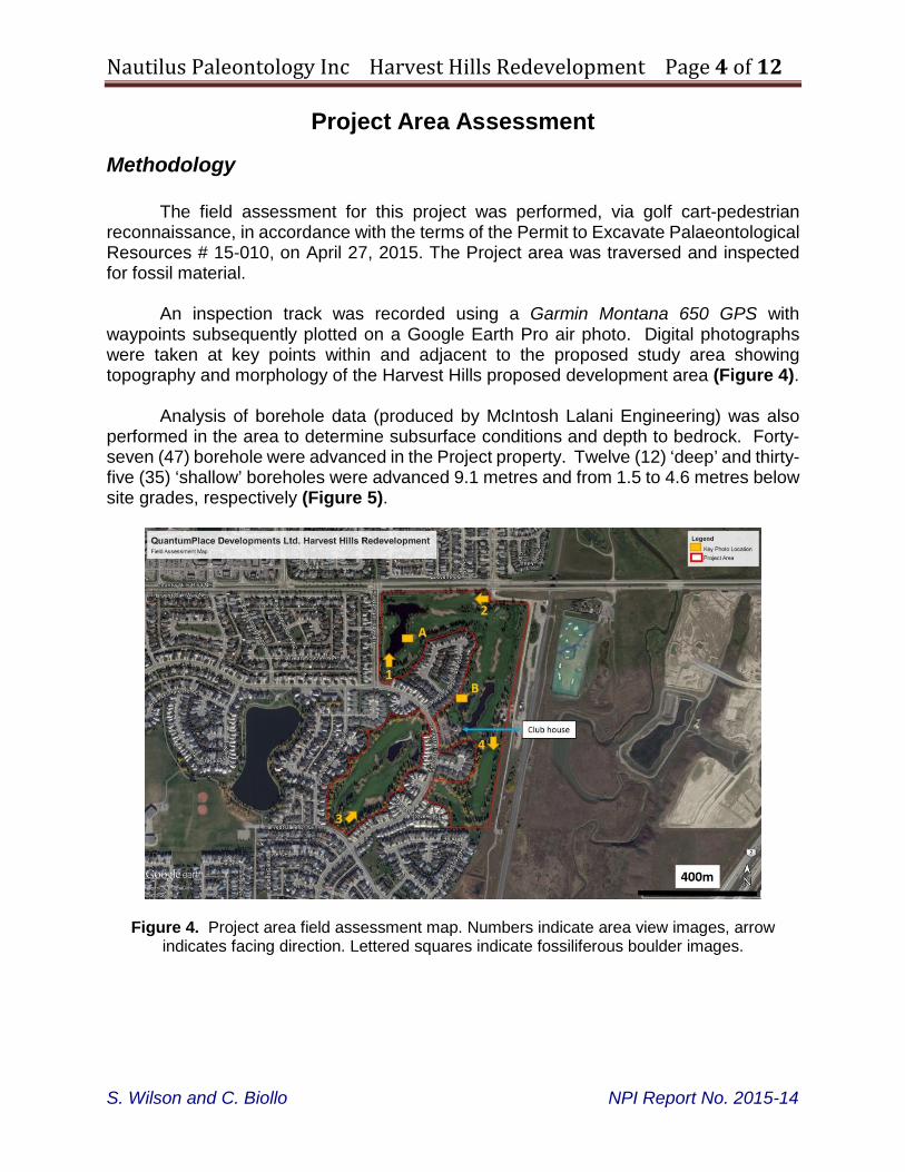
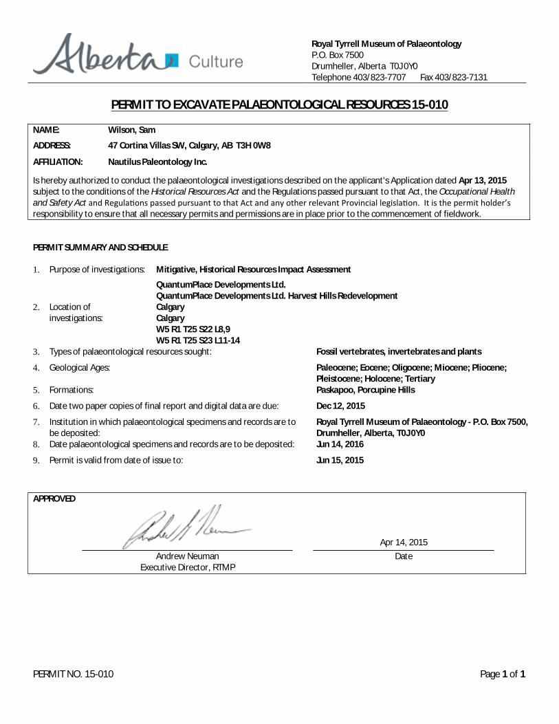
The field assessment for this project was performed, via golf cart-pedestrian reconnaissance, in accordance with the terms of the Permit to Excavate Palaeontological Resources # 15-010, on April 27, 2015. The Project area was traversed and inspected for fossil material.
An inspection track was recorded using a Garmin Montana 650 GPS with waypoints subsequently plotted on a Google Earth Pro air photo. Digital photographs were taken at key points within and adjacent to the proposed study area showing topography and morphology of the Harvest Hills proposed development area (Figure 4).
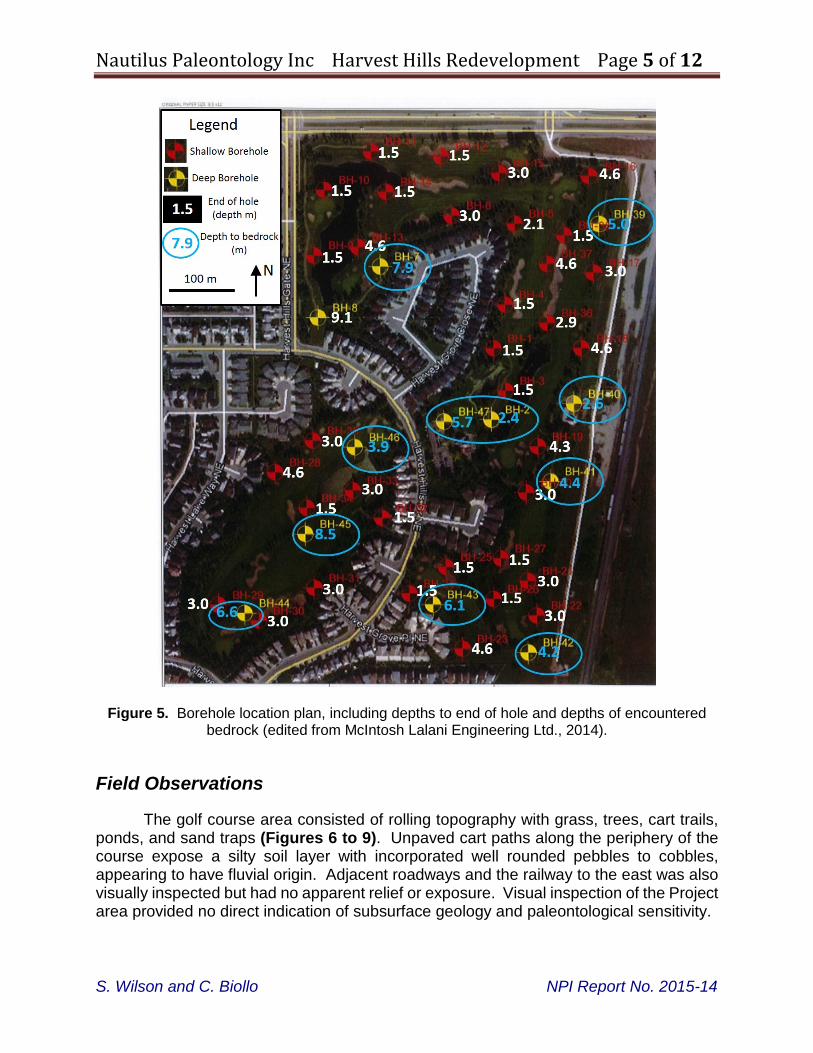
Analysis of borehole data (produced by McIntosh Lalani Engineering) was also performed in the area to determine subsurface conditions and depth to bedrock. Forty-seven (47) borehole were advanced in the Project property. Twelve (12) ‘deep’ and thirty-five (35) ‘shallow’ boreholes were advanced 9.1 metres and from 1.5 to 4.6 metres below site grades, respectively (Figure 5).
Figure 4. Project area field assessment map. Numbers indicate area view images, arrow indicates facing direction. Lettered squares indicate fossiliferous boulder images.
S. Wilson and C. Biollo NPI Report No. 2015-14
Nautilus Paleontology Inc Harvest Hills Redevelopment Page 5 of 12
Figure 5. Borehole location plan, including depths to end of hole and depths of encountered bedrock (edited from McIntosh Lalani Engineering Ltd., 2014).
Field Observations
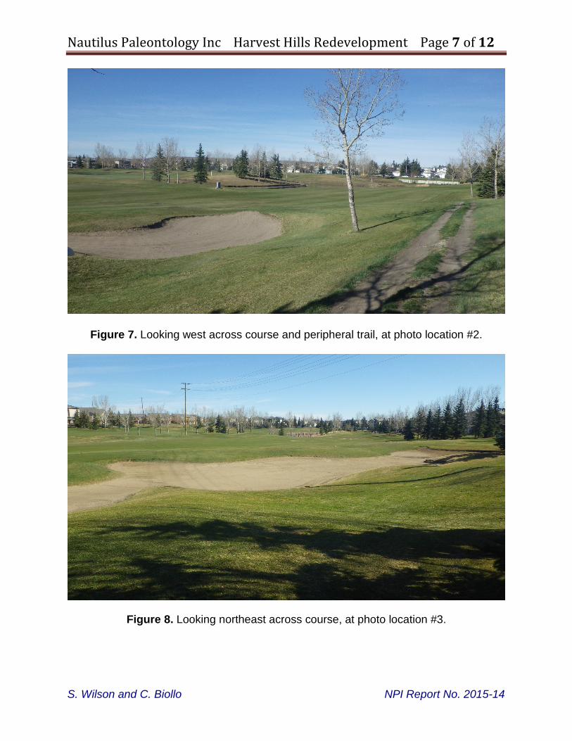
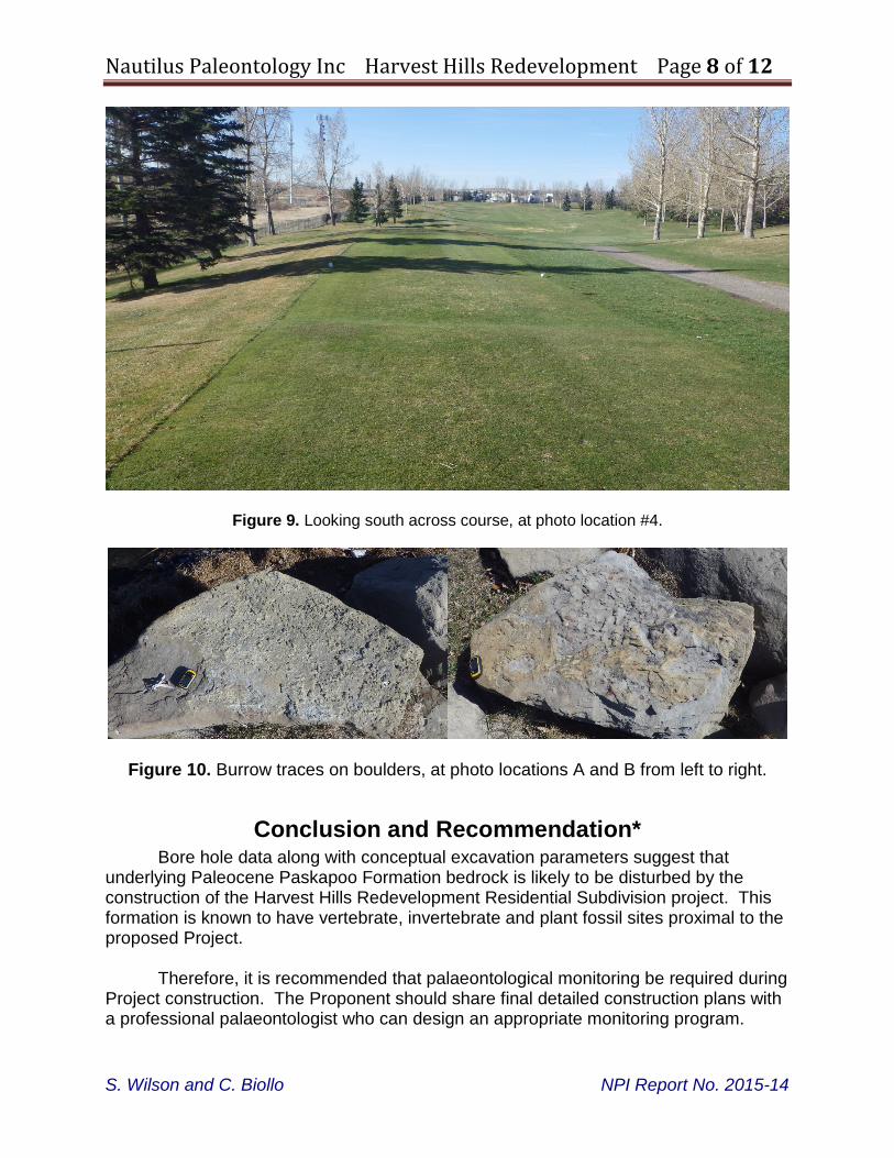
The golf course area consisted of rolling topography with grass, trees, cart trails, ponds, and sand traps (Figures 6 to 9). Unpaved cart paths along the periphery of the course expose a silty soil layer with incorporated well rounded pebbles to cobbles, appearing to have fluvial origin. Adjacent roadways and the railway to the east was also visually inspected but had no apparent relief or exposure. Visual inspection of the Project area provided no direct indication of subsurface geology and paleontological sensitivity.
S. Wilson and C. Biollo NPI Report No. 2015-14
Nautilus Paleontology Inc Harvest Hills Redevelopment Page 6 of 12
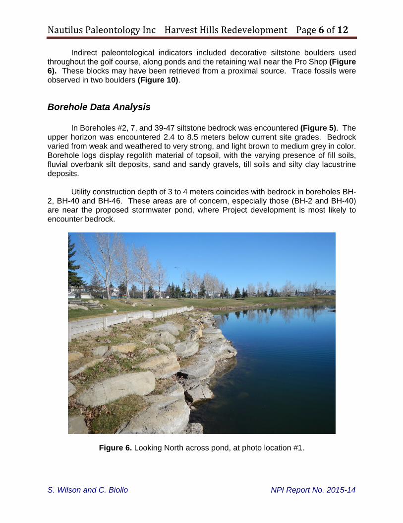
Indirect paleontological indicators included decorative siltstone boulders used throughout the golf course, along ponds and the retaining wall near the Pro Shop (Figure 6). These blocks may have been retrieved from a proximal source. Trace fossils were observed in two boulders (Figure 10).
Borehole Data Analysis
In Boreholes #2, 7, and 39-47 siltstone bedrock was encountered (Figure 5). The upper horizon was encountered 2.4 to 8.5 meters below current site grades. Bedrock varied from weak and weathered to very strong, and light brown to medium grey in color. Borehole logs display regolith material of topsoil, with the varying presence of fill soils, fluvial overbank silt deposits, sand and sandy gravels, till soils and silty clay lacustrine deposits.
Utility construction depth of 3 to 4 meters coincides with bedrock in boreholes BH-
2, BH-40 and BH-46. These areas are of concern, especially those (BH-2 and BH-40) are near the proposed stormwater pond, where Project development is most likely to encounter bedrock.
Figure 6. Looking North across pond, at photo location #1.
S. Wilson and C. Biollo NPI Report No. 2015-14
Nautilus Paleontology Inc Harvest Hills Redevelopment Page 7 of 12
Figure 7. Looking west across course and peripheral trail, at photo location #2.
Figure 8. Looking northeast across course, at photo location #3.
S. Wilson and C. Biollo NPI Report No. 2015-14
Nautilus Paleontology Inc Harvest Hills Redevelopment Page 8 of 12
Figure 9. Looking south across course, at photo location #4.
Figure 10. Burrow traces on boulders, at photo locations A and B from left to right.
Conclusion and Recommendation* Bore hole data along with conceptual excavation parameters suggest that
underlying Paleocene Paskapoo Formation bedrock is likely to be disturbed by the construction of the Harvest Hills Redevelopment Residential Subdivision project. This formation is known to have vertebrate, invertebrate and plant fossil sites proximal to the proposed Project.
Therefore, it is recommended that palaeontological monitoring be required during Project construction. The Proponent should share final detailed construction plans with a professional palaeontologist who can design an appropriate monitoring program.
S. Wilson and C. Biollo NPI Report No. 2015-14
Nautilus Paleontology Inc Harvest Hills Redevelopment Page 9 of 12
Report authorization This report has been written by:
_____________________ Samuel M. Wilson May 5, 2015
_____________________ Catherine Biollo May 5, 2015 *Disclaimer required by Alberta Culture: “Any recommendations made in this report are not necessarily consistent with the requirements of the Historical Resources Act
S. Wilson and C. Biollo NPI Report No. 2015-14
Samuel M. Wilson
Nautilus Paleontology Inc Harvest Hills Redevelopment Page 10 of 12
References Demchuk, T.P, and Hills, L.V., 1991. A Re-examination of the Paskapoo Formation in the
Central Alberta Plains: The Designation of Three New Members, Bulletin of Canadian Petroleum Geology, v. 39, no. 3, pages 270-282.
Fenton, M.M., Waters, E.J., Pawley, S.M, Atkinson, N., Utting, D.J. and Mckay, K. 2013: Surficial Geology of Alberta; Energy Resources Conservation Board, ERCB/AGS Map 601, scale 1:1,000,000.
Fox, R.C., 1990. The Succession of Paleocene Mammals in Western Canada, in Brown, T.M. and Rose, K.D., eds., Dawn of the Age of Mammals in the Northern Part of the Rocky Mountain Interior, North America: Boulder Colorado, Geological Society of America, Special Paper 243.
Grande, L., Li, G.-q, Wilson, Mark V.H, 2002. Amia cf. pattersoni from the Paleocene Paskapoo Formation on Alberta, Canadian Journal of Earth Science, v. 37, pp 31-37.
Hoffman, G. L, and Stockey, R.A., 1999. Geological Setting and the Paleobotany of the Joffre Bridge Roadcut Fossil Locality, (Late Paleocene), Red Deer Valley, Alberta. Canadian Journal of Earth Science, v. 36, pp. 2073-2294.
Lerbekmo, J.F., and Sweet, A. R., 2000. Magnetostratigraphy and Biostratigraphy of the Continental Paleocene of the Calgary Area, Bulletin of Canadian Petroleum Geology, v. 40, no. 4, pages 285-306.
McIntosh Lalani Engineering Ltd., 2014. Geotechnical Evaluation, Harvest Hills Golf Course Redevelopment, Calgary, Alberta. M.L. 7010.
Murray, A.M., and Wilson, M.V.H., 1996. A New Paleocence Genus and Species of Percopsiform (Teleostei: Paracanthopterygii) from the Paskapoo Formation, Smoky Tower, Alberta. Canadian Journal of Earth Science, v.33 pp 429-438.
Naylor, B.G., and Fox, R.C., 1993. A New Ambystomatid salamander, Dicamptodon antiquus n. sp. from the Paleocene of Alberta, Canada. Canadian Journal of Earth Science, v.30, pp 814-818.
Prior, G.J., Hathway, B., Glombick, P.M., Pana, D.J, Banks, C.J., Hay, D.C., Schneider. C.L, Grobe, M., Elgr, R., Weiss, J.A. (3013): Bedrock geology of Alberta; Alberta Energy Regulator, AER/AGS Map 600, scale: 1:1,000,000.
Scott, C.S., 2003. Late Torrejonian (Middle Paleocene) Mammals from South Central Alberta: Journal of Paleontology, v.77 no. 4, pages 745-768
Scott, C.S., 2006, Webb, M.C., and Fox, R.C., Horolodectes Sunae, An Enigmatic Mammal from the Late Paleocene of Alberta, Canada: Journal of Paleontology, v. 80, No. 3, pages 1009-1025.
S. Wilson and C. Biollo NPI Report No. 2015-14
Nautilus Paleontology Inc Harvest Hills Redevelopment Page 11 of 12
Scott, C.S., Spivak, D. N., and Sweet, A.R. 2013. First mammals from the Paleocene Porcupine Hills Formation of southwestern Alberta, Canada. Canadian Journal of Earth Sciences, v. 50, pp 355-378.
Simpson, G.G., 1927. Mammalian Fauna and Correlation of the Paskapoo Formation in Alberta. American Museum Novitates, v. 268, pp 2-10.
S. Wilson and C. Biollo NPI Report No. 2015-14
Nautilus Paleontology Inc Harvest Hills Redevelopment Page 12 of 12
APPENDIX
Schedule A, HRA Requirements File 4825-15-0037-001
RTMP Permit to Excavate Palaeontological Resources 2015-010
S. Wilson and C. Biollo NPI Report No. 2015-14
April 8, 2015
OPaC: 006486509
HISTORICAL RESOURCES ACT REQUIREMENTS
QUANTUMPLACE DEVELOPMENTS LTD.
QUANTUMPLACE DEVELOPMENTS LTD. - HARVEST HILLS REDEVELOPMENT RESIDENTIAL SUBDIVISION
HRA REQUIREMENTS PROJECT FILE: 4835-15-0037-001
(Schedule “A”)
For the purposes of this Schedule QuantumPlace Developments Ltd. shall be referred to as the “Proponent” and QuantumPlace Developments Ltd. - Harvest Hills Redevelopment shall be referred to as the “Project”.
1.0 PALAEONTOLOGICAL RESOURCES
The potential for this Project to affect palaeontological resources is high.
1.1 Historic Resources Impact Assessment
Pursuant to Section 37(2) of the Historical Resources Act a Historic Resources Impact Assessment (HRIA) for palaeontological resources and any work resulting from this assessment is to be conducted on behalf of the Proponent by a palaeontologist qualified to hold a “Permit to Excavate Palaeontological Resources (Mitigative)” within the Province of Alberta. In order to conduct the HRIA, the palaeontological consultant must submit "An Application for Permit to Excavate Palaeontological Resources (Mitigative)" to the Royal Tyrrell Museum of Palaeontology. Please allow ten working days for the permit to be processed. An approved permit must be issued prior to the initiation of any palaeontological field investigations.
1.1.1 Alberta Regulation 254/2002
Palaeontological investigations conducted under permit in Alberta are subject to the conditions stated within Alberta Regulation 254/2002, Archaeological and Palaeontological Research Permit Regulation, conditions set forth in the approved permit, and any other conditions that the Minister imposes under Section 30 of the Historical Resources Act.
1.1.2 Contacting the Royal Tyrrell Museum of Palaeontology
For further information regarding the acquisition of a “Permit to Excavate Palaeontological Resources”, the conduct of the required palaeontological resource HRIA and/or palaeontological consultants obligations under Alberta Regulation 254/2002, please contact Dan Spivak, Head, Resource Management, Royal Tyrrell Museum of Palaeontology at 403-820-6210 (toll-free 310-0000) or [email protected]
SCHEDULE A 4835-15-0037-001
April 8, 2015 Page 2 of 3
1.1.3 Coverage
The HRIA must include all areas of high palaeontological potential within the Project area.
1.1.4 Timing
The HRIA is to be carried out prior to the initiation of any land surface disturbance activities under snow free, unfrozen ground conditions.
1.2 Reporting the Results of the Palaeontological Resources HRIA
1.2.1 Submission of specimen data sheets
The Proponent’s palaeontological consultant is required to submit “Palaeontological Specimen Data Sheets” for each fossil collected during mitigative studies.
1.2.2 Submission of HRIA final report for palaeontological resources
A digital copy of the HRIA final report must be submitted within 180 days after the expiration of the permit, or at least six weeks prior to the anticipated conduct of land surface disturbance activities, whichever comes first. The final report and interim reports are to be submitted to the Historic Resources Management Branch, Heritage Division, Alberta Culture and Tourism using the Online Permitting and Clearance (OPaC) system.
1.2.3 Submission of interim report(s) for palaeontological resources
Should the Proponent find it necessary to obtain Historical Resources Act approval for portions or all of the lands affected by the Project prior to the submission of the final report, Alberta Culture and Tourism will consider accepting the submission of an interim report, or reports.
2.0 REPORTING THE DISCOVERY OF HISTORIC RESOURCES
During the conduct of historic resources studies a consultant may encounter historic resources that are not the subject of their field of expertise. Under this circumstance, the consultant must follow instructions included in Attachment 1, Standard Requirements under the Historical Resources Act, Reporting the Discovery of Historic Resources. The Proponent must also comply with standard conditions under the Historical Resources Act, which are applicable to all land surface disturbance activities in the Province. Standard conditions require applicants to report the discovery of historic resources. These requirements are stated in Attachment 1- Standard Requirements under the Historical Resources Act, Reporting the Discovery of Historic Resources.
3.0 FURTHER SALVAGE, PRESERVATIVE OR PROTECTIVE MEASURES
Based upon the results of the HRIA(s), reporting the discovery of archaeological resources, palaeontological resources, historic period sites and/or Aboriginal Traditional Use Site(s) of a type described in Attachment 2, the Proponent may be ordered to undertake further salvage, preservative or protective measures or take any other actions that the Minister responsible for the Historical Resources Act considers necessary.
SCHEDULE A 4835-15-0037-001
April 8, 2015 Page 3 of 3
4.0 REQUESTS FOR HISTORICAL RESOURCES ACT APPROVAL
Based upon the results of the HRIA studies, Alberta Culture and Tourism may consider granting Historical Resources Act approval to all or portions of the Project area. In the final report, and any interim report(s) the Proponent’s consultant(s) must clearly identify and illustrate those portions of the Project area for which Historical Resources Act approval is requested.
5.0 PRE-EMINENCE OF HISTORICAL RESOURCES ACT REQUIREMENTS
Should the contents of conditions included within this Schedule be at variance with any instructions associated with the Listing of Historic Resources and/or the permit application, the conditions of the Schedule take precedence. Following instructions as outlined in this Schedule should result in the granting of Historical Resources Act approval and/or the issuance of requirements regarding further historic resources studies in a timely manner.
6.0 COMPLIANCE IS MANDATORY
These conditions shall be considered directions of the Minister of Alberta Culture and Tourism under the Act. The Proponent and agents acting on behalf of the Proponent are required to become knowledgeable of the conditions. Failure to abide by the conditions will result in Historical Resources Act approval not being granted, or delayed.
Royal Tyrrell Museum of PalaeontologyP.O. Box 7500Drumheller, Alberta T0J 0Y0Telephone 403/823-7707 Fax 403/823-7131
PERMIT TO EXCAVATE PALAEONTOLOGICAL RESOURCES 15-010
NAME: Wilson, Sam
ADDRESS: 47 Cortina Villas SW, Calgary, AB T3H 0W8
AFFILIATION: Nautilus Paleontology Inc.
Is hereby authorized to conduct the palaeontological investigations described on the applicant's Application dated Apr 13, 2015subject to the conditions of the Historical Resources Act and the Regulations passed pursuant to that Act, the Occupational Healthand Safety Act and Regulations passed pursuant to that Act and any other relevant Provincial legislation. It is the permit holder’sresponsibility to ensure that all necessary permits and permissions are in place prior to the commencement of fieldwork.
PERMIT SUMMARY AND SCHEDULE
Purpose of investigations:1. Mitigative, Historical Resources Impact Assessment
QuantumPlace Developments Ltd.QuantumPlace Developments Ltd. Harvest Hills Redevelopment
Location of2.investigations:
CalgaryCalgaryW5 R1 T25 S22 L8,9W5 R1 T25 S23 L11-14
Types of palaeontological resources sought:3. Fossil vertebrates, invertebrates and plants
Geological Ages:4. Paleocene; Eocene; Oligocene; Miocene; Pliocene;Pleistocene; Holocene; Tertiary
Formations:5. Paskapoo, Porcupine Hills
Date two paper copies of final report and digital data are due:6. Dec 12, 2015
Institution in which palaeontological specimens and records are to7.be deposited:
Royal Tyrrell Museum of Palaeontology - P.O. Box 7500,Drumheller, Alberta, T0J 0Y0
Date palaeontological specimens and records are to be deposited:8. Jun 14, 2016
Permit is valid from date of issue to:9. Jun 15, 2015
APPROVED
PERMIT NO. 15-010 Page 1 of 1
DateApr 14, 2015
Andrew NeumanExecutive Director, RTMP