Embed Size (px)
Citation preview
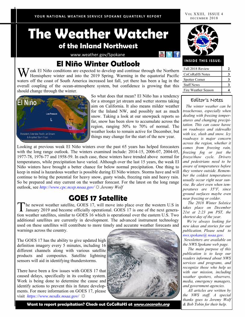
The Weather Watcher of the Inland Northwest
Y O U R N A T I O N A L W E A T H E R S E R V I C E S P O K A N E Q U A R T E R L Y R E P O R T V OL XXIII , ISSUE 4
DECEMBER 2018
www.weather.gov/Spokane
Fall 2018 Review 2
CoCoRaHS Notes 3
Spotter Corner 3
Staff News 3
Fire Weather Season 4
INSIDE THIS ISSUE:
Editor’s Notes The winter weather can be
treacherous, especially when
dealing with freezing temper-
atures and changing precipi-
tation. This can cause havoc
on roadways and sidewalks
with ice, slush and snow. Icy
roadways is major concern
across the region, whether it
comes from freezing rain,
freezing fog or just the
freeze/thaw cycle. Drivers
and pedestrians need to be
aware of temperatures before
they venture outside. Remem-
ber the coldest temperatures
usually occur right near sun-
rise. Be alert even when tem-
peratures are 35°F, since
ground surfaces maybe even
near freezing or colder.
The 2018 Winter Solstice
takes place on December
21st at 2:23 pm PST, the
shortest day of the year.
We’re always looking for
new ideas and stories for our
publication. Please send to
nws.spokane@ noaa.gov.
Newsletters are available on
the NWS Spokane web page.
The main purpose of this
publication is to keep our
readers informed about NWS
services and programs, and
recognize those who help us
with our mission, including
weather spotters, observers,
media, emergency managers,
and government agencies.
All articles are written by
the NWS staff. A special
thanks goes to Jeremy Wolf
& Bob Tobin for their help.
El Niño Winter Outlook W eak El Niño conditions are expected to develop and continue through the Northern
Hemisphere winter and into the 2019 Spring. Warming in the equatorial Pacific
waters off the coast of South America increased last fall, yet there has been a lag in the
overall coupling of the ocean-atmosphere system, but confidence is growing that this
should change through the winter.
So what does that mean? El Niño has a tendency
for a stronger jet stream and wetter storms taking
aim on California. It also means milder weather
for the Inland NW, and possibly not as much
snow. Taking a look at our snowpack reports so
far, snow has been slow to accumulate across the
region, ranging 50% to 70% of normal. The
weather looks to remain active for December, but
things may change for the start of the new year.
Looking at previous weak El Niño winters over the past 65 years has helped forecasters
with the long range outlook. The winters examined include: 2014-15, 2006-07, 2004-05,
1977-78, 1976-77 and 1958-59. In each case, these winters have trended above normal for
temperatures, while precipitation have varied. Although over the last 15 years, the weak El
Niño winters have brought a better chance for below normal precipitation. One thing to
keep in mind is hazardous weather is possible during El Niño winters. Storms have and will
continue to bring the potential for heavy snow, gusty winds, freezing rain and heavy rain.
So be prepared and stay current on the weather forecast. For the latest on the long range
outlook, see http://www.cpc.ncep.noaa.gov/ ☼ Jeremy Wolf
GOES 17 Satellite T he newest weather satellite, GOES 17, will move into place over the western U.S in
January 2019 and become officially operational. GOES 17 is one of the next genera-
tion weather satellites, similar to GOES 16 which is operational over the eastern U.S. Two
additional satellites are currently in development. The advanced instrument technology
used on these satellites will contribute to more timely and accurate weather forecasts and
warnings across the country.
The GOES 17 has the ability to give updated high
definition imagery every 5 minutes, including 16
different channels along with various satellite
products and composites. Satellite lightning
sensors will aid in identifying thunderstorms.
There have been a few issues with GOES 17 that
caused delays, specifically in its cooling system.
Work is being done to determine the cause and
identify actions to prevent this in future develop-
ments. For more information on GOES 17, please
visit https://www.nesdis.noaa.gov/ ☼
Want to report precipitation? Check out CoCoRaHS at www.cocorahs.org
V OL XXIII , ISSUE 4 P AGE 2
September lived up to its reputation as being a very quiet
month and very dry. Spokane, Lewiston, and Wenatchee all
picked up less than .05” of rain for the month. This dry
weather was an extension of the dry summer where
Wenatchee tied for the driest July through September on
record while Spokane came in 3rd driest. The main event
for the month occurred on the 7th with a strong cold front
passage which brought thunderstorms, strong winds, and
blowing dust. A couple of strong storms occurred around
Winthrop with abundant lightning, while a second one
tracked from Conconully to Tonasket with 40-50 mph wind
gusts causing power outages. As the front moved east strong
winds kicked up significant blowing dust in the Columbia
Basin with visibility as low as 1/16 of a mile in Ritzville,
and 1 mile in Spokane. Winds gusted to 54 mph at Fairchild
Air Force Base. Another round of blowing dust arrived on
the 29th as northeast winds gusted to 30 to 35 mph in the
Columbia Basin.
October started off on an active note as a robust cold front
passage brought strong winds, thunderstorms, blowing dust,
and even mountain snow. The strongest winds occurred near
the Canadian border as well as in North Central Washington
where thunderstorms near the Canadian border may have
enhanced the wind gusts. Numerous trees were blown down
in and north of the Colville area. Wind gusts include 70 mph
Oroville, 64 mph Chelan, 53 mph Omak, 52 mph Ephrata,
50 mph Wenatchee, and 46 mph Moses Lake. These winds
also created blowing dust in the Columbia Basin reducing
visibility down to 2 to 5 miles with one report as low as
1/16 of a mile in Othello. Lastly, rain changed to snow over
Stevens Pass bringing an early season snowfall. Strong high
pressure brought a prolonged stretch of dry weather from
the 10th through the 24th before the wet season kicked in on
the 25th.
November started off with spring like conditions with
temperatures in the 50s to lower 60s, a couple of wind
events near the Cascades, and even isolated thunderstorms.
A strong cold front on the 2nd brought a burst of heavy rain
to Wenatchee late in the evening with a 58 mph wind gust.
On the 4th another wind event brought localized tree dam-
age and power outages around Leavenworth with gusts to
55 mph in the mountains, 48 mph Chelan, and 45 mph
Wenatchee. On the 5th a thunderstorm just south of
Spokane tracked from Medical Lake and Cheney east into
Rockford producing occasional lightning and small hail.
High pressure then brought a couple weeks of dry weather
with several rounds of low clouds and fog. The pattern
turned much more active on Thanksgiving Day. A wintry
mix fell in Central Washington with Wenatchee receiving
its first snow of the season as a weak system passed
through. Slick roads contributed to a bus rollover near
George involving the University of Washington marching
band with around 40 people taken to the hospital for
evaluation. A cold and unstable system on the 23rd brought
heavy snow to the mountains with a closure of Snoqualmie
Pass and chains required over Stevens Pass where around a
foot of snow fell. Rain changed to snow between Spokane
and Pullman making for a memorable Apple Cup where 1 to
3 inches was reported. Rosalia picked up 4 inches from the
storm. This was all after a mild afternoon when Pullman
reached 48°F. ☼ Jeremy Wolf
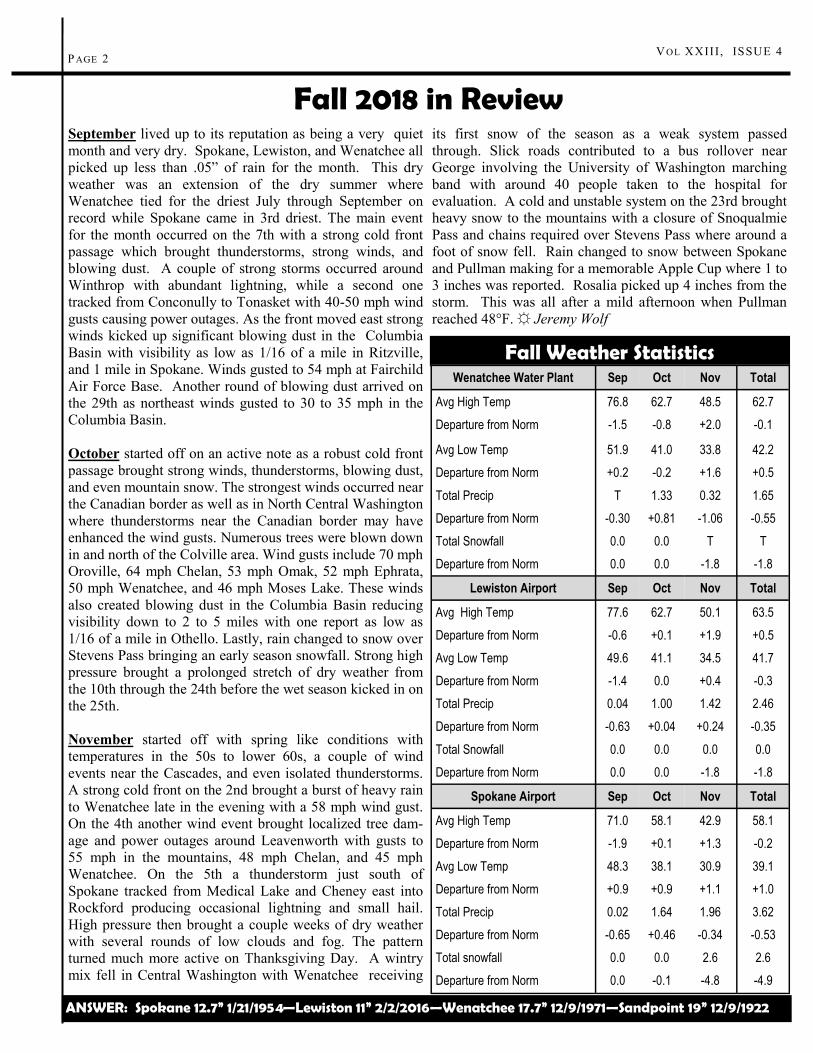
Fall 2018 in Review
Fall Weather Statistics Wenatchee Water Plant Sep Oct Nov Total
Avg High Temp 76.8 62.7 48.5 62.7
Departure from Norm -1.5 -0.8 +2.0 -0.1
Avg Low Temp 51.9 41.0 33.8 42.2
Departure from Norm +0.2 -0.2 +1.6 +0.5
Total Precip T 1.33 0.32 1.65
Departure from Norm -0.30 +0.81 -1.06 -0.55
Total Snowfall 0.0 0.0 T T
Departure from Norm 0.0 0.0 -1.8 -1.8
Lewiston Airport Sep Oct Nov Total
Avg High Temp 77.6 62.7 50.1 63.5
Departure from Norm -0.6 +0.1 +1.9 +0.5
Avg Low Temp 49.6 41.1 34.5 41.7
Departure from Norm -1.4 0.0 +0.4 -0.3
Total Precip 0.04 1.00 1.42 2.46
Departure from Norm -0.63 +0.04 +0.24 -0.35
Total Snowfall 0.0 0.0 0.0 0.0
Departure from Norm 0.0 0.0 -1.8 -1.8
Spokane Airport Sep Oct Nov Total
Avg High Temp 71.0 58.1 42.9 58.1
Departure from Norm -1.9 +0.1 +1.3 -0.2
Avg Low Temp 48.3 38.1 30.9 39.1
Departure from Norm +0.9 +0.9 +1.1 +1.0
Total Precip 0.02 1.64 1.96 3.62
Departure from Norm -0.65 +0.46 -0.34 -0.53
Total snowfall 0.0 0.0 2.6 2.6
Departure from Norm 0.0 -0.1 -4.8 -4.9
ANSWER: Spokane 12.7” 1/21/1954—Lewiston 11” 2/2/2016—Wenatchee 17.7” 12/9/1971—Sandpoint 19” 12/9/1922
THE WEATHER WATCHER P AGE 3
SPOTTER REPORTS: (509) 244-0435
CoCoRaHS Notes N WS Spokane has seen an increase in
observer sign ups this fall with 20 new
observers. This was highlighted by a rain gauge
give-away at the Spokane Interstate Fair. To enter
the contest, new recruits signed up for the CoCo-
RaHS program and a name was drawn from this
list. The winner was one of newest CoCoRaHS
observer in WA-SP-59 Ms. Houk.
For those that still need of a rain gauge, you can
order them online at www.weatheryourway.com/
cocorahs/store.html. It’s the official 4 inch stand-
ard rain gauge. What a great gift idea that can be
used all year long! There are more great items
available at the online CoCoRaHS store.
The CoCoRaHS staff performs quality control and
looks over all of the reports across the county. If
they see a potential error, they will email the
CoCoRaHS regional coordinators and ask for their
assistance to reach the observer. There have been
times that we have contacted our local observers
to clear up any errors. In most cases, the errors are
minor ranging from a misplaced decimal point or a
report entered into the wrong spot. Our goal is to
have the most complete precipitation reports
possible and we appreciate the time you take to
complete your CoCoRaHS reports, especially in
the winter time when the weather can be active.
Keep up the good work! ☼ Robin Fox
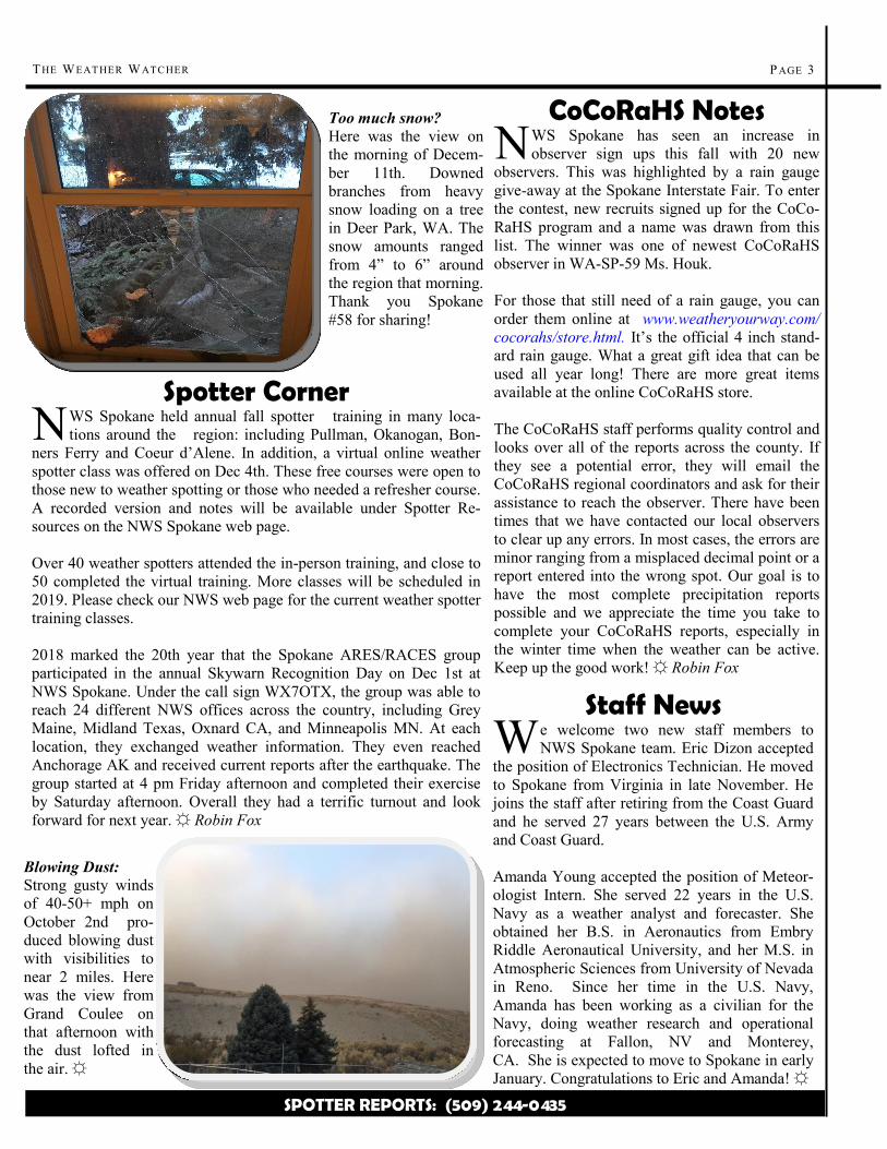
Too much snow?
Here was the view on
the morning of Decem-
ber 11th. Downed
branches from heavy
snow loading on a tree
in Deer Park, WA. The
snow amounts ranged
from 4” to 6” around
the region that morning.
Thank you Spokane
#58 for sharing!
Staff News W e welcome two new staff members to
NWS Spokane team. Eric Dizon accepted
the position of Electronics Technician. He moved
to Spokane from Virginia in late November. He
joins the staff after retiring from the Coast Guard
and he served 27 years between the U.S. Army
and Coast Guard.
Amanda Young accepted the position of Meteor-
ologist Intern. She served 22 years in the U.S.
Navy as a weather analyst and forecaster. She
obtained her B.S. in Aeronautics from Embry
Riddle Aeronautical University, and her M.S. in
Atmospheric Sciences from University of Nevada
in Reno. Since her time in the U.S. Navy,
Amanda has been working as a civilian for the
Navy, doing weather research and operational
forecasting at Fallon, NV and Monterey,
CA. She is expected to move to Spokane in early
January. Congratulations to Eric and Amanda! ☼
Spotter Corner N WS Spokane held annual fall spotter training in many loca-
tions around the region: including Pullman, Okanogan, Bon-
ners Ferry and Coeur d’Alene. In addition, a virtual online weather
spotter class was offered on Dec 4th. These free courses were open to
those new to weather spotting or those who needed a refresher course.
A recorded version and notes will be available under Spotter Re-
sources on the NWS Spokane web page.
Over 40 weather spotters attended the in-person training, and close to
50 completed the virtual training. More classes will be scheduled in
2019. Please check our NWS web page for the current weather spotter
training classes.
2018 marked the 20th year that the Spokane ARES/RACES group
participated in the annual Skywarn Recognition Day on Dec 1st at
NWS Spokane. Under the call sign WX7OTX, the group was able to
reach 24 different NWS offices across the country, including Grey
Maine, Midland Texas, Oxnard CA, and Minneapolis MN. At each
location, they exchanged weather information. They even reached
Anchorage AK and received current reports after the earthquake. The
group started at 4 pm Friday afternoon and completed their exercise
by Saturday afternoon. Overall they had a terrific turnout and look
forward for next year. ☼ Robin Fox
Blowing Dust:
Strong gusty winds
of 40-50+ mph on
October 2nd pro-
duced blowing dust
with visibilities to
near 2 miles. Here
was the view from
Grand Coulee on
that afternoon with
the dust lofted in
the air. ☼
National
Weather Service
2601 N Rambo Rd
Spokane, WA 99224
(509)-244-0110
P AGE 4 THE WEATHER WATCHER
Remember your Winter Spotter
Checklist
Trivia: What was the snowiest day
across the Inland NW?
The Weather Watcher
Of the Inland Northwest
Watch : Conditions are favorable for severe or hazardous weather around the watch area.
CAUTION—Watch the Sky!
Warning : Severe or hazardous weather is likely or is occurring in the warned area.
DANGER—ACT NOW!
Follow NWS Spokane on Facebook and Twitter!
Snow: 2”+ valleys & 4”+ mountains
Strong Winds: 30mph+ or damage
Reduced Visibility: under a mile due to fog, snow...
Hail: pea size or larger
Heavy Rain: Showery: 1/2” + in 1hr Steady: 1”+ in 12hr/1.5”+ in 24hr
Any Mixed Precipitation
Any Flooding
Travel Problems or Damage: due to severe/hazardous weather
0
200
400
600
800
1000
1200
1400
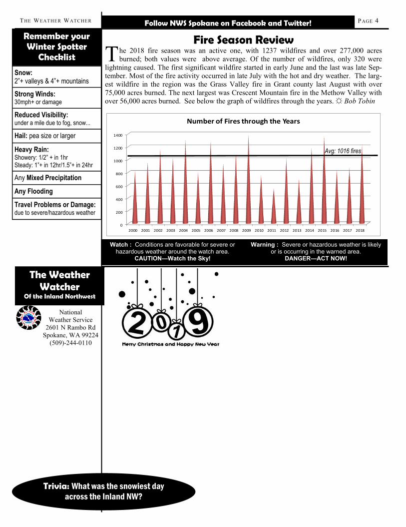
2000 2001 2002 2003 2004 2005 2006 2007 2008 2009 2010 2011 2012 2013 2014 2015 2016 2017 2018
Number of Fires through the Years
Avg: 1016 fires
Fire Season Review
T he 2018 fire season was an active one, with 1237 wildfires and over 277,000 acres
burned; both values were above average. Of the number of wildfires, only 320 were
lightning caused. The first significant wildfire started in early June and the last was late Sep-
tember. Most of the fire activity occurred in late July with the hot and dry weather. The larg-
est wildfire in the region was the Grass Valley fire in Grant county last August with over
75,000 acres burned. The next largest was Crescent Mountain fire in the Methow Valley with
over 56,000 acres burned. See below the graph of wildfires through the years. ☼ Bob Tobin