Embed Size (px)
Citation preview
Three Early Spanish Tampa Bay Maps
By CHARLES W. ARNADE*
One of the most difficult chapters of Florida history is historical car-tography of Florida or the story of the mapping of all or parts of Florida.As a matter of fact, most trained historians, anthropologists or archaeologistsof the Florida scene gladly shy away when it comes to old Florida maps. Thisis not because old maps from the Spanish periods and the English interludeare scarce; they are plentiful. After spending a whole month working full-time with Florida maps I came to the conclusion that it is easy to accumulateas many as five hundred or more different maps made during the two Spanishand the English periods. These maps are not only Spanish or English chartsbut there are also many in French, especially in French archives. The earlysixteenth century maps came mostly from Portugal, Italy and even Germany.In the early seventeenth century one must also look to the great Dutch mapmakers who produced gorgeous atlases. We have an abundance of maps,charts, diagrams, etc. dealing with Florida. But the "historico-cartographicalresearch" (to use the expression of the great explorer and cartographer AdolfErik Nordenskiold) of Florida has been neglected. There is no doubt that theAtlas of Florida recently published by the University of Florida Press is ofvalue but it is more for the layman and its historical value is only a briefsummary. It never intended to be anything else. After all, history is onlyone of over twenty parts and it is more "a pictorial presentation of Florida'spresent" than the past. The atlas is of no value for important and detailedresearch in historical cartography of Florida.
The difficulty lies in the dispersion of sources-all over the world-ofthe key Florida depositories. The libraries on the state university campuses,
*This Florida map research was undertaken thanks to a summer grantin August, 1963 from the William Clements Library of the University ofMichigan at Ann Arbor. This grant was financed by the Lilly EndowmentFoundation. I wish to express my thanks to the Clements Library and theLilly Foundation for their generous support. No footnotes have been providedas the reader can easily detect the sources mentioned from the bibliography.
83
84 TEQUESTA
state libraries in Tallahassee, places in St. Augustine and private collegelibraries all have copies of many maps, but they are thrown into folders ordrawers, or are lying in corners. Not a single Florida librarian is a truemap expert or has dedicated himself to a systematic study of Florida maps.A few men, including Mr. David True from Miami, have undertaken mapstudies but their writings are highly technical and generally argumentative-trying to show that the other fellow was wrong in his interpretation of thisor that map, as exemplified by the Caraci article. We lack good descriptiveguides such as the one done in 1912 by the great cartographer Phillip LeePhillips when he annotated the Woodbury Lowery collection of Americanmaps which has a wealth of Florida charts. We need to classify the maps,keep them in order, make them available, and we need to understand themand then discuss them. None of this has been done and therefore the historianand the anthropologist avoid this pile of confusion which in reality shouldbe one of his most important accessory tools.
I have a 140-page typed study of Sixteenth Century maps which I haveselected as important to the mapping of the peninsula of Florida. The secondpart of the study gives biographical data of several cartographers whosestudies I consider important to Florida cartography and Florida history. Andin the third part I single out a man and his important cartographic contribu-tion to the Florida scene. This is Dr. Louis C. Karpinski (1878-1956) who asProfessor of Mathematics of the University of Michigan was an avid studentand collector of early maps dealing with North America. He took many tripsto various European archives in search for maps. His collection of photostatscontains over seven hundred maps, mostly unpublished, known as the Kar-pinski Collection. These photostats are available in a few university libraries,but not in Florida (except a few isolated parts). I consulted the Universityof Michigan Karpinski Collection located at the William Clements Libraryof Rare Americana. I made a list of all maps dealing with Florida, exclusiveof Pensacola, and copied the Karpinski annotations and I hope to publish thelist in the third and last part of my above mentioned map study. My studyis not technical, but is an attempt to bring some order into a confusing pic-
ture. Its purpose is also to bring an awareness of the availability of mapsand their importance to Florida history. I have limited myself to the Six-
teenth cenury because much that has been written deals with this period andit is highly technical and arguable, therefore of limited comprehension anduse as a secondary source. Then I decided to acquaint the Florida audience
CHARLES W. ARNADE 85
with cartographers who have written about Florida, and finally I list theFlorida maps of the Karpinski Collection for further studies of the mappingof Florida during the Seventeenth and Eighteenth Centuries.
In doing my research at the delightful and respected William ClementsLibrary I ran into many interesting maps depicting various areas of Florida.One thing became obvious in studying the maps of the first Spanish period.The Spaniards mapped the Florida coast very well but they were deficientwith regard to the interior. On the coast certain areas were far better mappedthan others. The coastline from the Cape to Charleston was the best studiedand recorded. The tip of the peninsula-the roundout from about Miami toFort Myers-was the worst mapped. But the Keys were well studied and theKarpinski Collection has some exciting maps of the Keys. The Gulf coast ofthe panhandle was well mapped only with the permanent establishment ofPensacola in the Eighteenth century.
The same is true of the Gulf coast of the peninsula and especially itscentral section with Tampa Bay as the heart of this coastal area. The wholehistory of Tampa Bay-when it was first discovered, its subsequent impor-tance to the Spaniards and the inability of the Spaniards to properly recordthe Bay-has not been studied. But I believe Spanish documentation isabundantly available. One would have to go through the rich collection ofSpanish documents reaching far over one hundred thousand sheets of docu-ments (most of them at the P. K. Yonge Library at the University of Florida)to locate data on Tampa Bay. There is no doubt the Spanish knew the Bay.But there also is no doubt in my mind that regardless of the Sixteenth centurylandings at or nearby the Bay and its appearance, erroneous as it may be,on Sixteenth century maps, exact knowledge of the Bay was always question-able and indeed it was forgotten for long intervals. As a matter of fact,there does not seem to exist-at least not located so far-a fairly detailed mapof the Tampa Bay area done during the Sixteenth or Seventeenth century.Apparently the first maps we have come from the second half of the Eighteenthcentury-all within a short period of time. Indeed three unrelated maps ofTampa Bay have been located. Their dates are 1757, 1783, and the thirdis undated, but must go back to the Spanish period. This means that the firstmap dates back to the very end of the First Spanish Period and the 1783map falls into the Second Spanish Period.

86 TEQUESTA
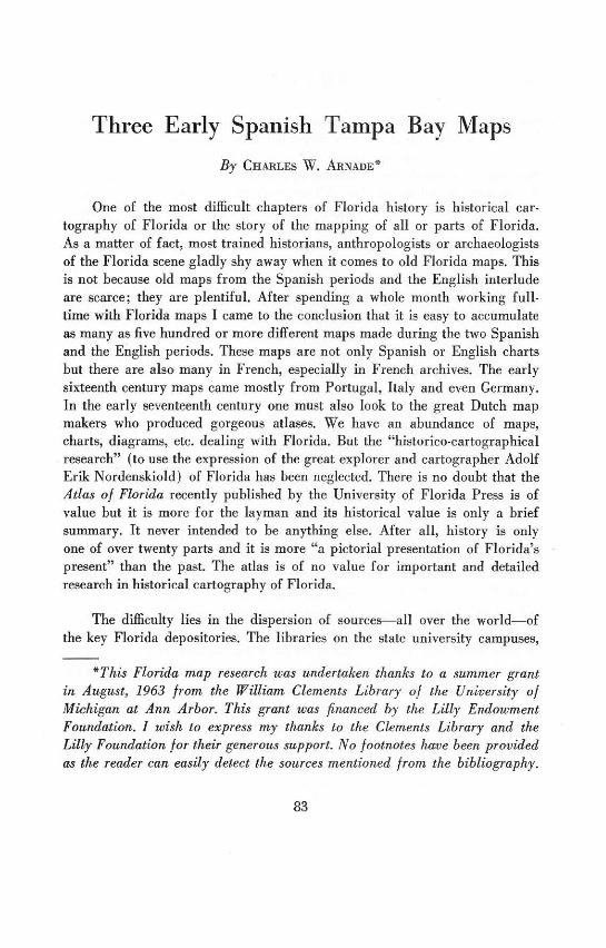
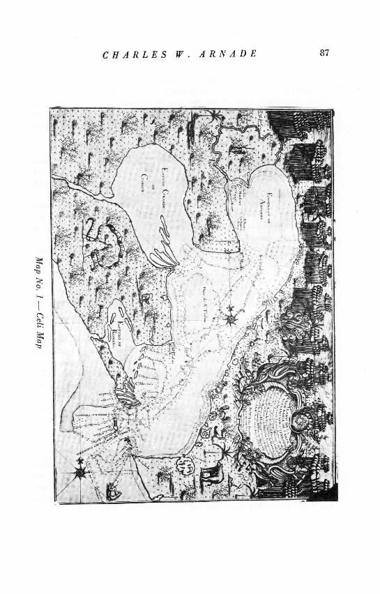
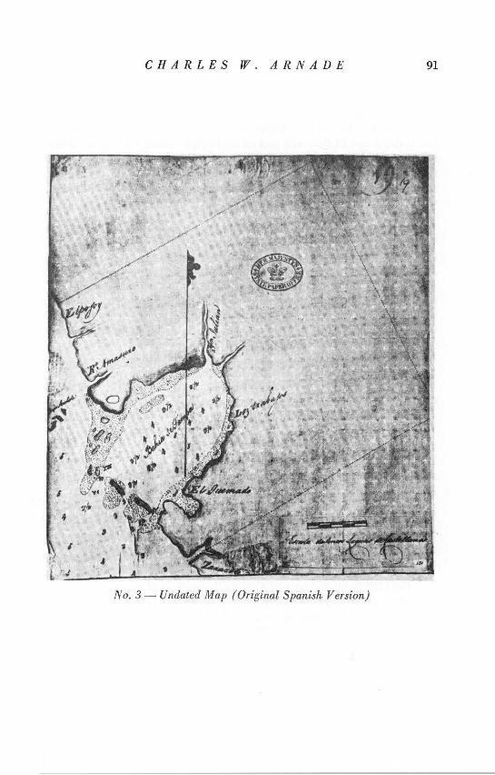
The 1757 map (no. 1) is probably the most detailed chart of the threehere described and we know its author and we have a definite date. Theadorned inscription says that it is a "chart of the great bay of Tampa, andagain [named] San Fernando." It states that this bay is located at Latitude290 west of Tenerife. It says that this chart was drawn by the order of theGeneral Commander of the Royal naval forces in Habana, Blas de Barreda,and the Inspector of the Naval Ministry in Habana, Lorenzo de Montalva.The actual charting expedition of an unknown number of ships was underthe command of the Spanish "pilot", Francisco Maria Celi. I have notsearched for biographical data about Maria Celi, but I am sure that tediousefforts in the documents would result in positive data such as found aboutthe man who composed the 1873 map. Looking for information on such aman is a long affair of trial and error but often leads to interesting new facts.This Tampa Bay map-to my mind the best of the Spanish maps-shouldencourage more background information which would include a search forMaria Celi.
This map is according to my experience the earliest detailed map ofTampa Bay. The map was known to the late Clarence Simpson who in hisexcellent Florida Place-Names of Indian Derivation under the entry writesthat "the first careful hydrographic survey of the present Tampa Bay appearsto have been made in 1787 by Don Francisco Maria Celi, pilot of the RoyalSpanish Navy, who although recognizing the then current name of Tampa,renamed it San Fernando...." Neither Simpson nor Dr. Mark F. Boyd ofTallahassee, who edited the Simpson compilation, tell where they located themap or information of the map. But other historians who have written aboutTampa and the Southwest coast apparently were unaware of the vital MariaCeli map. The able archaeologist, Ripley P. Bullen of the Florida StateMuseum in Gainesville, told this author that he was aware of the mapsthanks to the courtesy of Dr. Boyd.
My copy comes from the Karpinski Collection and is listed number 193 inthe William Clements Library Karpinski classification. Karpinski found theoriginal in the Spanish Naval Museum in Madrid under the Classification9a-2a,43 and the original is 66.4 to 47 centimeters in size. Karpinski does nottell us if it is in color but because of its exquisite drawings I assume that itmust be in color. Some municipal, educational or cultural organization inthe Tampa Bay area should get an exact copy of this map and display it ina conspicuous place to the public. I think it is a key document and it is an
CHARLES W. ARNADE 87
,'os
OF i;F 17 m-, >t. * ,, 6 l
I ,;"• .U, ..
you All,+.
.10 1 Tr
1 ý4.
VIAWAY
88 TEQUESTA
artistic work. I am not qualified to judge the geographical or nauticalaccuracy of this map or the others. But I find the drawings and the nameshighly interesting. First of all, the map shows only one native inhabitedarea, where today's Highway 41 runs between Gibsonton and Ruskin. Atthe same time, the map does not have the Alafia and Little Manatee Riversin this area.
The map shows no Indian settlements in what are today the urban areasof Tampa, Clearwater and St. Petersburg. The animals depicted do notreveal any novelty. Interesting is the vegetation, and the huge tall palmclusters certainly meant that there were large palms. The name given tovarious spots and to the bays and rivers make a fascinating story. For exam-ple, the map proves beyond any doubt that the word Pinellas comes fromthe Spanish word pinal and today's Pinellas Point has the same name as inthe 1757 map where it is identified as Punta de Pinal de Ximenez. Most ofthe other names mentioned in the map, with some exceptions as Boca Ziega,have not survived. Only the Hillsborough and Palm Rivers were given namesby Maria Celi and they were called San Julian Arriaga, and Franco re-spectively. Old Tampa Bay and Hillsborough Bay were named Estero Grandede Girior and Ensefiada de Aguirre. All the other names should entice interest-ing comparisons with a modern map. I assume that the soundings and thetide lines and the coastal configurations are of great interest to cartographicand nautical experts. Naturally all kinds of implications and deductions canbe made in the game of names. There are today such names as Palma Ceiaand Terra Ceia and Terra Ceia Island. What does Ceia mean or from whatdoes it derive? Attorney William Goza of the Florida Historical Society inconversation thinks that it is a derivation from the Spanish word "ceja"which usually means eyebrow but can also mean projecting part or bridge.This certainly makes much sense. But it can also be a derivative of Celi (thepilot who chartered the Tampa Bay area in 1757)-the author of this map.His name was given on this map to a small cape in Hillsborough Bay neartoday's Davis Island.
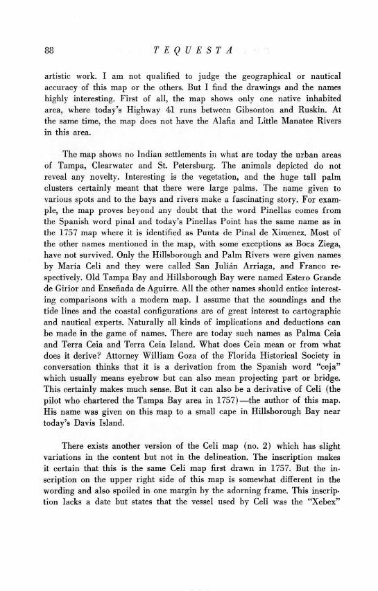
There exists another version of the Celi map (no. 2) which has slightvariations in the content but not in the delineation. The inscription makesit certain that this is the same Celi map first drawn in 1757. But the in-scription on the upper right side of this map is somewhat different in thewording and also spoiled in one margin by the adorning frame. This inscrip.tion lacks a date but states that the vessel used by Celi was the "Xebex"
CHARLES W. ARNADE 89
Ile .:J -
rIr
90 TEQUESTA
named San Francisco. A xebex is a small, three-master ship having anoverhanging bow and stern and both square and lateen sails. This inscriptionalso identifies a Lieutenant [ ? ] Xim6nez as the commander of the xebex SanFrancisco. It is not known if this version (no. 2) or the other version whichhas the date of the Celi expedition (no. 1) is the original. Apparently theNo. 2 map in the heavily adorned lower left scale (not adorned in the No. 1map) has on the very edge a date which is so tiny that every effort with allthe modern means available has failed to make the date legible. The best guessis 1763. Everyone consulted, including Dr. Bullen, seems to think that no. 2is the reproduction and no. 1 the original. The no. 2 map lacks much of thedrawing of the animals and the vegetation. Only the scale box is moreadorned. This No. 2 version, which we think is the reproduction, is available.It is shown in the book by Arthur P. Whitaker, Documents Relating to theCommercial Policy of Spain in the Floridas, p. 156. Dr. Whitaker fails tocite the date of the map and only identifies it as "Map of Tampa Bay(Eighteenth Century.)"
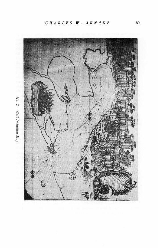
Our next map (no. 3) is far less detailed and is the undated map. Wehave no record of an author. Two versions have been located-one withEnglish words and the other in Spanish. It obviously is a Spanish map whichwas used during the English Period. I feel positive that the map was done inthe last decades of the First Spanish Period. This map comes from a series ofmaps sketching the area from St. Augustine and Jacksonville through Gaines-ville to Tampa Bay. These sectional maps are available in the EnglishCrown Collection of Maps of North America: Section Three, the originals
of which are in the Public Record Office in London, but have been made
available as photostats in a multivolume edition by Archer Butler Hulbert.
This collection is available in Florida in the library of the Florida State
University in Tallahassee. This Tampa Bay chart is plate 131 of Series III of
the Crown Collection and the FSU lists 1785 as the date. This to my mind is
erroneous. The related maps of the St. Augustine-Gainesville area have been
published by Dr. James C. Covington in his 1961 Seminole study. Covington
has the more neatly drawn English version. The original Spanish maps were
reproduced by me in my 1961 cattle study. But Covington reproduced the
Tampa Bay section in its English version. The map presented here (no. 3)
is the more detailed original Spanish version. Covington located his maps in
the legal claims of Messrs. Gordon and Fish and he was unaware of their
existence as originals in the Crown collection.
CHARLES W. ARNADE 91
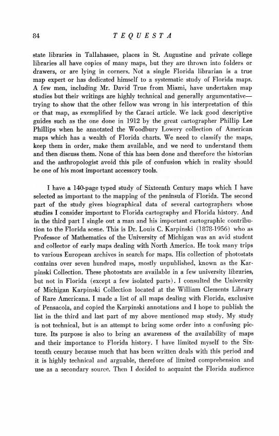
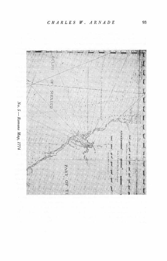
No. 3- Undated Ma (Oriinal Sanish Version)
No. 3 - Undated Map (Original Spanish Version)
92 TEQUESTA
As one can see, the Spanish version has sounds in the Bay. The map isquite crude and the configuration very primitive with hardly any names.One can see that in the original version two points in the Bay are identified asLos Trabajos and El Quemado (not on the English version.) The same namesin the same places are given on the 1757 map. I think that this map antedatesthe 1757 map. It is also interesting to note that in the Spanish version thename Zarazote is listed more or less where Sarasota is today. The Englishversion has the name copied as Zararote. This map has its value.
Maybe the third chart* (no. 4)-the one of 1783, the first year of thesecond Spanish occupation-should not be included here, since the Englishperiod produced excellent maps especially by such men as Romans andJeffreys. There is especially the often quoted Romans map of Tampa Bay of1774 (no. 5). This is the one which all researchers know and which is con-tinually cited when the history of Tampa Bay is discussed. Consequentlyit is not described here as I was interested in presenting new maps with newinformation. But I must say that all the three maps described here shouldbe compared with the English charts, especially the Romans Tampa Bay map.It must also be said that both Romans and especially Andrew Ellicott in hisimportant journal published in 1802 (republished 1962), speak of a carefulsurvey done at a very early date-before Maria Celi-of Tampa Bay byCaptain Braddock. The vital Ellicott Journal first published in 1802 wasapparently unknown to Simpson. Ellicott wrote, "On the West side of EastFlorida it affords two remarkable fine harbors: One is known by the nameof Hillsborough Bay (Bay Tampa [sic] or Spirito Santo). The latitude is270 36 N. and the longitude 830 West from Greenwich. It is very spacious,and will admit any vessel over the bar not drawing more than twenty-fourfeet water. The first Englishman who explored, and gave an account ofthis bay was a Capt. Braddock who commanded a privateer from Virginiaand cruised on the west coast of East Florida, in the years 1744 and 1745:his survey is yet considered as good as any extant (p. 27)." No Braddockmap has been located-apparently the survey and map are lost. The MariaCeli map still remains the earliest known map of Tampa.
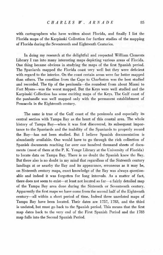
The 1783 Spanish chart (no. 4) is the Tampa map of Jose de Evia whichI stated might not totally fit into our scheme because it belongs to the SecondSpanish Period. I located my copy in the Karpinski Collection and theClements Library classification is Map No. 164. Karpinski found the original
*See page 98
CHARLES W. ARNADE 93
'It
1 -. .. / ]· •Y . ,..... /,
0' .,
cd I tr, ~
1 /1
94 TEQUESTA
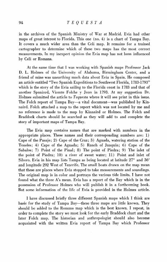
in the archives of the Spanish Ministry of War at Madrid. Evia had othermaps of great interest to Florida. This one (no. 4) is a chart of Tampa Bay.It covers a much wider area than the Celi map. It remains for a trainedcartographer to determine which of these two maps has the most correctmeasurements. In my inexpert opinion the Evia map has not been influencedby Celi or Romans.
At the same time that I was working with Spanish maps Professor JackD. L. Holmes of the University of Alabama, Birmingham Center, and afriend of mine was unearthing much data about Evia in Spain. He composedan article entitled "Two Spanish Expeditions to Southwest Florida, 1783-1793"which is the story of the Evia sailing to the Florida coast in 1783 and that ofanother Spaniard, Vicente Folche y Juan in 1793. At my suggestion Dr.Holmes submitted the article to Tequesta where it will see print in this issue.The Folch report of Tampa Bay-a vital document-was published by Kin-naird. Folch attached a map to the report which was not located by me andno reference is made to the map by Kinnaird or Holmes. The Folch andBraddock charts should be searched as they will add to and complete thestory of important maps of Tampa Bay.
The Evia map contains names that are marked with numbers in theappropriate places. These names and their corresponding numbers are: 1)Cape of the Pasaje; 2) Cape of the Cruz; 3) Aguada, watering station of theToneles; 4) Cape of the Aguada; 5) Ranch of Juaquin; 6) Cape of theSabalos; 7) Point of the Pinal; 8) The point of Piedra; 9) The inlet ofthe point of Piedra; 10) a river of sweet water; 11) Point and inlet ofSiboro. Evia in his map lists Tampa as being located at latitude 270 and 36'and longitude 292 West of Tenerife. The small boats drawn on the map meanthat these are places where Evia stopped to take measurements and soundings.The original map is in color and portrays the various tide limits. I have notfound what the three A's mean. Evia has a report of the Bay which is in thepossession of Professor Holmes who will publish it in a forthcoming book.But some information of the life of Evia is provided in the Holmes article.
I have discussed briefly three different Spanish maps which I think arebasic for the study of Tampa Bay-these three maps are little known. Theyshould be added to the Romans map which is the best known. I repeat, inorder to complete the story we must look for the early Braddock chart and thelater Folch map. The historian and anthropologist should also becomeacquainted with the written Evia report of Tampa Bay which Professor
CHARLES W. ARNADE 95
Holmes will publish in his book and the Folch report published by Kin-naird. I am sure that true and dedicated research will produce additionalsources. The early story of the chartering, exploration and settlement ofTampa Bay has not yet been told with accuracy. I think it can be done bytedious but rewarding research.
BIBLIOGRAPHYArnade, Charles W. "Cattle Raising in Spanish Florida, 1513-1763," Agricultural His-
tory, XXXV (1961), 116-124.
"Florida History in Spanish Archives," Florida Historical Quarterly,XXXIV (1955), 36-50.
"A Guide to Spanish Florida Source Material," Florida Historical Quar-terly, XXXV (1957), 320-325.
---- . "Mapping and Map Scholars of Early Florida" (unpublished monograph)."Recent Problems in Florida History," Florida Historical Quarterly, XLII
(1963), 1-15.
[British Government.] Catalogue of the Manuscript Maps, Charts, and Plans and of theTopographical Drawings in the British Museum. 2 (?) vols. London, 1861.
[ .1 Catalogue of the Maps, Plans and Charts in the Library of the ColonialOffice. No place, 1910. No pagination.
[ .1 Catalogue of the Printed Maps, Plans, and Charts in the British Museum.2 vols. London, 1885.
Brun, Christian, editor. Guide to the Manuscript Maps in the William L. Clements Library.Ann Arbor, 1959. 209 pp.
Caraci, Giuseppe. "The Reputed Inclusion of Florida in the Oldest Nautical Maps of theNew World," Imago Mundi, XV (1960), 32-39.
Covington, James W. The British Meet the Seminoles. Negotiations between BritishAuthorities in East Florida and the Indians: 1763-68. Contributions of the FloridaState Museum, Social Sciences, No. 7. Gainesville, 1961. 66 pp.
Cumming, William P. The Southeast in Early Maps. With an Annotated Checklist ofPrinted and Manuscript Regional and Local Maps of the Southeastern North Americaduring the Colonial Period. Princeton, 1958. 275 pp. and maps.
Ellicott, Andrew. The Journal of Andrew Ellicott. Americana Classics, Quadrangle Books.Chicago, 1962. [1st ed., 1802.] 300 pp., numerous plates.
Gordon, John and Jesse Fish. The Case of Mr. John Gordon with Respect to the Titleto Certain Lands in East Florida.... London, 1772. 32 pp. and long unpagedappendix.
Holmes, Jack D. L. "Two Spanish Expeditions to Southwest Florida, 1783-1793," Tequestano. XXV (1965).
Hulbert, Archer Butler, editor. The Crown Collection of Photographs of American Maps.Series I. 5 vols. Cleveland, Ohio, 1907.
, editor. The Crown Collection of Photographs of American Maps. Series II.5 vols. Harrow, England, 1909-1912.
[ , editor.] The Crown Collection of Photographs of American Maps. SeriesIII. [no place, no date; London, 1914-1916?] 250 plates (in 4 vols.), plates 47 to131 deal with Florida.
96 TEQUESTA
Karpinski, L. C. "Atlases of the Sixteenth and Seventeenth Centuries," William ClementsLibrary Bulletin, no. 4 (1924), 4 pp.
S"Cartographical Collections in America," Imago Mundi, I (1935), 62-64.
S"Introduction to the Karpinski Collection of Photographs of Maps inFrench, Spanish and Portuguese Archives Relating to Colonial America" (loosehandwritten notes, unpublished) in the Karpinski files, Map Division, WilliamClements Library.
S"Manuscript Maps Relating to America in French, Spanish and PortugueseArchives," American Historical Review, XXXIII (1928), 328-330.
Kinnaird, Lawrence, editor. "Problems of Frontier Defense, 1792-1794," in Annual Reportof the American Historical Association for the Year 1945, Vol. IV: Spain in theMississippi Valley, 1765-1794, pp. 237-242. Washington, 1946.
Lowery, Woodbury and Philip Lee Phillips. The Lowery Collection. A Descriptive Listof Maps of the Spanish Possession within the Present Limits of the United States,1502-1820. Washington, 1912. 567 pp.
Michigan, University of. Bibliography of Publications by Members of the SeveralFaculties. Old and new series. 1924-1945. Contains Karpinski bibliography.
Michigan, University of. The Karpinski Collection of Photographic Copies of Early Mapsof America, William Clements Library (no index, no pagination). Maps arenumbered from 1 to 772.
Karpinski Correspondence, Vertical File, Map Division, William ClementsLibrary (incomplete).
_ L. C. Karpinski folder, Main Library, Reference Desk, Faculty Folders(contains information for a biography of Prof. Karpinski, 1878-1956).
Phillips, Philip Lee. A List of Maps of America in the Library of Congress Preceded bya List of Works Relating to Cartography. Washington, 1901. 1137 pp.
SNotes on the Life and Works of Bernard Romans. DeLand, Fla., 1924.144 pp.
Raisz, Erwin and John R. Dunkle, editors. Atlas of Florida. Gainesville, Fla., 1964.52 pp.
Romans, Bernard. A Concise Natural History of East and West Florida. New York, 1775.(Reprinted in facsimile in 1962 by the University of Florida Press.) Tampa Baymap on p. lxxviii.
Simpson, Clarence J., author, and Mark F. Boyd, editor. Florida Place-Names of IndianDerivation. State Board of Conservation. Tallahassee, 1956. 158 pp.
[Spanish Government.] Servicio Geogrifico del Ejercito. Cartografia de Ultramar. CarpetaVI: Estados Unidos y Canada. Madrid, 1953.
Torres Lanzas, Pedro. Relaci6n descriptiva de los mapas, planos, etc. de Mexico y Florida,existentes en el Archive General de Indias. Seville, 1900.
True, David O. "Cabot Explorations in North America," Imago Mundi, XIII (1956), 11-25."John Cabot's Maps and Voyages," Congresso International de Hist6ria dos
Descobrimientos (Lisbon), Actas: II, 1-23. 1961.
__ "Some Early Maps Relating to Florida," Imago Mundi, XI (1954), 73-84.
Wagner, Herman. "Adolf Erik von Nordenskiold," K. Gessellschaft der Wissenschaften zuGottingen, I (1902), 12 pp.
Whitaker, Arthur Preston. Documents Relating to the Commercial Policy of Spain inthe Floridas. DeLand, Fla., 1931.
Wroth, Lawrence C. "Source Materials of Florida History in the John Carter BrownLibrary of Brown University," Florida Historical Quarterly, XX (1941), 3-46.