Embed Size (px)
Citation preview
Thunderstorm
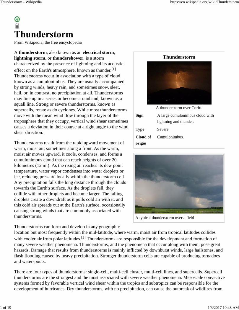
A thunderstorm over Corfu.
Sign A large cumulonimbus cloud with
lightning and thunder.
Type Severe
Cloud of
origin
Cumulonimbus.
A typical thunderstorm over a field
From Wikipedia, the free encyclopedia
A thunderstorm, also known as an electrical storm,lightning storm, or thundershower, is a stormcharacterized by the presence of lightning and its acousticeffect on the Earth's atmosphere, known as thunder.[1]
Thunderstorms occur in association with a type of cloudknown as a cumulonimbus. They are usually accompaniedby strong winds, heavy rain, and sometimes snow, sleet,hail, or, in contrast, no precipitation at all. Thunderstormsmay line up in a series or become a rainband, known as asquall line. Strong or severe thunderstorms, known assupercells, rotate as do cyclones. While most thunderstormsmove with the mean wind flow through the layer of thetroposphere that they occupy, vertical wind shear sometimescauses a deviation in their course at a right angle to the windshear direction.
Thunderstorms result from the rapid upward movement ofwarm, moist air, sometimes along a front. As the warm,moist air moves upward, it cools, condenses, and forms acumulonimbus cloud that can reach heights of over 20kilometres (12 mi). As the rising air reaches its dew pointtemperature, water vapor condenses into water droplets orice, reducing pressure locally within the thunderstorm cell.Any precipitation falls the long distance through the cloudstowards the Earth's surface. As the droplets fall, theycollide with other droplets and become larger. The fallingdroplets create a downdraft as it pulls cold air with it, andthis cold air spreads out at the Earth's surface, occasionallycausing strong winds that are commonly associated withthunderstorms.
Thunderstorms can form and develop in any geographiclocation but most frequently within the mid-latitude, where warm, moist air from tropical latitudes collideswith cooler air from polar latitudes.[2] Thunderstorms are responsible for the development and formation ofmany severe weather phenomena. Thunderstorms, and the phenomena that occur along with them, pose greathazards. Damage that results from thunderstorms is mainly inflicted by downburst winds, large hailstones, andflash flooding caused by heavy precipitation. Stronger thunderstorm cells are capable of producing tornadoesand waterspouts.
There are four types of thunderstorms: single-cell, multi-cell cluster, multi-cell lines, and supercells. Supercellthunderstorms are the strongest and the most associated with severe weather phenomena. Mesoscale convectivesystems formed by favorable vertical wind shear within the tropics and subtropics can be responsible for thedevelopment of hurricanes. Dry thunderstorms, with no precipitation, can cause the outbreak of wildfires from
Thunderstorm - Wikipedia https://en.wikipedia.org/wiki/Thunderstorm
1 of 19 1/3/2017 10:48 AM
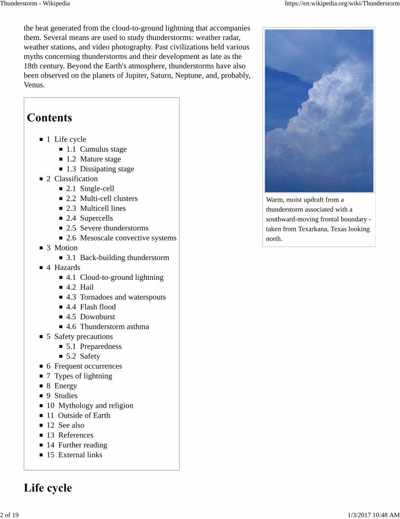
Warm, moist updraft from a
thunderstorm associated with a
southward-moving frontal boundary -
taken from Texarkana, Texas looking
north.
the heat generated from the cloud-to-ground lightning that accompaniesthem. Several means are used to study thunderstorms: weather radar,weather stations, and video photography. Past civilizations held variousmyths concerning thunderstorms and their development as late as the18th century. Beyond the Earth's atmosphere, thunderstorms have alsobeen observed on the planets of Jupiter, Saturn, Neptune, and, probably,Venus.
1 Life cycle1.1 Cumulus stage1.2 Mature stage1.3 Dissipating stage
2 Classification2.1 Single-cell2.2 Multi-cell clusters2.3 Multicell lines2.4 Supercells2.5 Severe thunderstorms2.6 Mesoscale convective systems
3 Motion3.1 Back-building thunderstorm
4 Hazards4.1 Cloud-to-ground lightning4.2 Hail4.3 Tornadoes and waterspouts4.4 Flash flood4.5 Downburst4.6 Thunderstorm asthma
5 Safety precautions5.1 Preparedness5.2 Safety
6 Frequent occurrences7 Types of lightning8 Energy9 Studies10 Mythology and religion11 Outside of Earth12 See also13 References14 Further reading15 External links
Thunderstorm - Wikipedia https://en.wikipedia.org/wiki/Thunderstorm
2 of 19 1/3/2017 10:48 AM
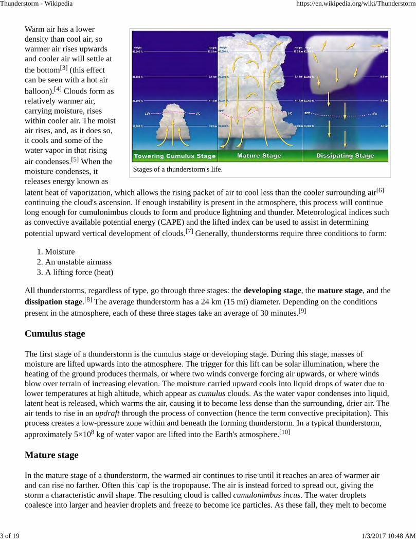
Stages of a thunderstorm's life.
Warm air has a lowerdensity than cool air, sowarmer air rises upwardsand cooler air will settle atthe bottom[3] (this effectcan be seen with a hot airballoon).[4] Clouds form asrelatively warmer air,carrying moisture, riseswithin cooler air. The moistair rises, and, as it does so,it cools and some of thewater vapor in that risingair condenses.[5] When themoisture condenses, itreleases energy known aslatent heat of vaporization, which allows the rising packet of air to cool less than the cooler surrounding air[6]
continuing the cloud's ascension. If enough instability is present in the atmosphere, this process will continuelong enough for cumulonimbus clouds to form and produce lightning and thunder. Meteorological indices suchas convective available potential energy (CAPE) and the lifted index can be used to assist in determiningpotential upward vertical development of clouds.[7] Generally, thunderstorms require three conditions to form:
Moisture1. An unstable airmass2. A lifting force (heat)3.
All thunderstorms, regardless of type, go through three stages: the developing stage, the mature stage, and thedissipation stage.[8] The average thunderstorm has a 24 km (15 mi) diameter. Depending on the conditionspresent in the atmosphere, each of these three stages take an average of 30 minutes.[9]
Cumulus stage
The first stage of a thunderstorm is the cumulus stage or developing stage. During this stage, masses ofmoisture are lifted upwards into the atmosphere. The trigger for this lift can be solar illumination, where theheating of the ground produces thermals, or where two winds converge forcing air upwards, or where windsblow over terrain of increasing elevation. The moisture carried upward cools into liquid drops of water due tolower temperatures at high altitude, which appear as cumulus clouds. As the water vapor condenses into liquid,latent heat is released, which warms the air, causing it to become less dense than the surrounding, drier air. Theair tends to rise in an updraft through the process of convection (hence the term convective precipitation). Thisprocess creates a low-pressure zone within and beneath the forming thunderstorm. In a typical thunderstorm,approximately 5×10⁸ kg of water vapor are lifted into the Earth's atmosphere.[10]
Mature stage
In the mature stage of a thunderstorm, the warmed air continues to rise until it reaches an area of warmer airand can rise no farther. Often this 'cap' is the tropopause. The air is instead forced to spread out, giving thestorm a characteristic anvil shape. The resulting cloud is called cumulonimbus incus. The water dropletscoalesce into larger and heavier droplets and freeze to become ice particles. As these fall, they melt to become
Thunderstorm - Wikipedia https://en.wikipedia.org/wiki/Thunderstorm
3 of 19 1/3/2017 10:48 AM
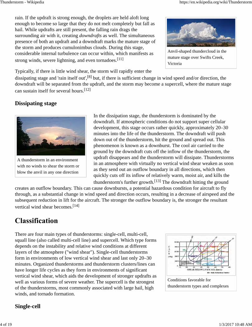
Anvil-shaped thundercloud in the
mature stage over Swifts Creek,
Victoria
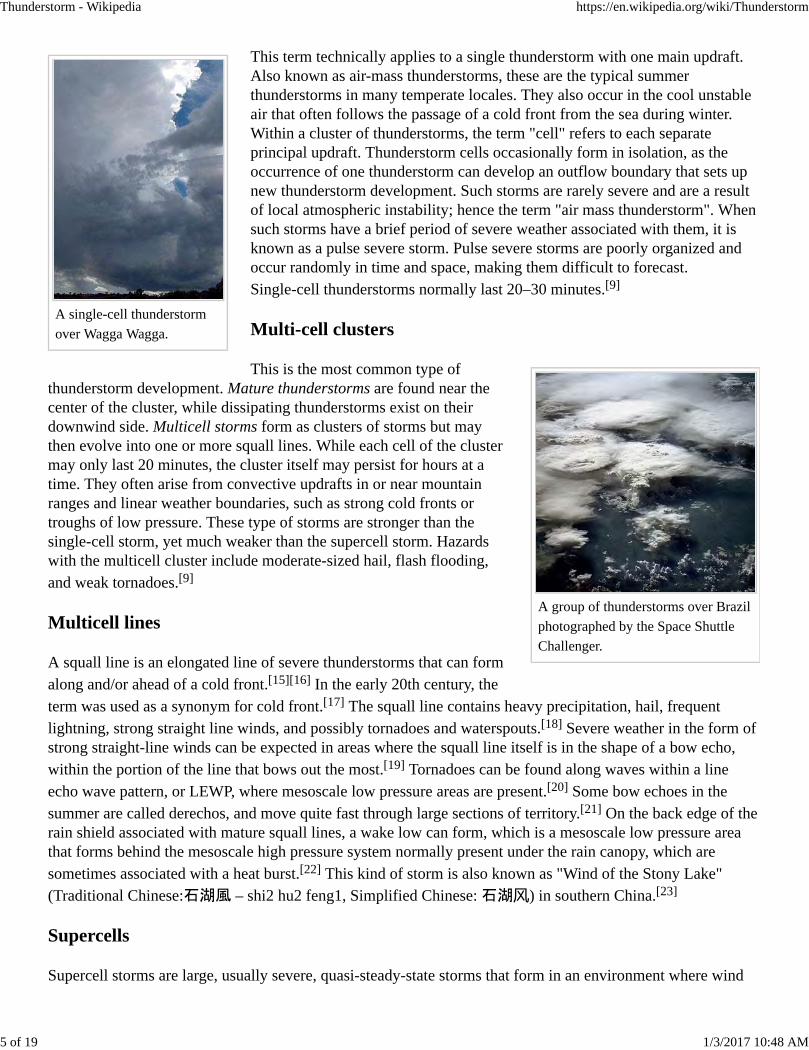
A thunderstorm in an environment
with no winds to shear the storm or
blow the anvil in any one direction
Conditions favorable for
thunderstorm types and complexes
rain. If the updraft is strong enough, the droplets are held aloft longenough to become so large that they do not melt completely but fall ashail. While updrafts are still present, the falling rain drags thesurrounding air with it, creating downdrafts as well. The simultaneouspresence of both an updraft and a downdraft marks the mature stage ofthe storm and produces cumulonimbus clouds. During this stage,considerable internal turbulence can occur within, which manifests asstrong winds, severe lightning, and even tornadoes.[11]
Typically, if there is little wind shear, the storm will rapidly enter thedissipating stage and 'rain itself out',[8] but, if there is sufficient change in wind speed and/or direction, thedowndraft will be separated from the updraft, and the storm may become a supercell, where the mature stagecan sustain itself for several hours.[12]
Dissipating stage
In the dissipation stage, the thunderstorm is dominated by thedowndraft. If atmospheric conditions do not support super cellulardevelopment, this stage occurs rather quickly, approximately 20–30minutes into the life of the thunderstorm. The downdraft will pushdown out of the thunderstorm, hit the ground and spread out. Thisphenomenon is known as a downburst. The cool air carried to theground by the downdraft cuts off the inflow of the thunderstorm, theupdraft disappears and the thunderstorm will dissipate. Thunderstormsin an atmosphere with virtually no vertical wind shear weaken as soonas they send out an outflow boundary in all directions, which thenquickly cuts off its inflow of relatively warm, moist air, and kills thethunderstorm's further growth.[13] The downdraft hitting the ground
creates an outflow boundary. This can cause downbursts, a potential hazardous condition for aircraft to flythrough, as a substantial change in wind speed and direction occurs, resulting in a decrease of airspeed and thesubsequent reduction in lift for the aircraft. The stronger the outflow boundary is, the stronger the resultantvertical wind shear becomes.[14]
There are four main types of thunderstorms: single-cell, multi-cell,squall line (also called multi-cell line) and supercell. Which type formsdepends on the instability and relative wind conditions at differentlayers of the atmosphere ("wind shear"). Single-cell thunderstormsform in environments of low vertical wind shear and last only 20–30minutes. Organized thunderstorms and thunderstorm clusters/lines canhave longer life cycles as they form in environments of significantvertical wind shear, which aids the development of stronger updrafts aswell as various forms of severe weather. The supercell is the strongestof the thunderstorms, most commonly associated with large hail, highwinds, and tornado formation.
Single-cell
Thunderstorm - Wikipedia https://en.wikipedia.org/wiki/Thunderstorm
4 of 19 1/3/2017 10:48 AM
A single-cell thunderstorm
over Wagga Wagga.
A group of thunderstorms over Brazil
photographed by the Space Shuttle
Challenger.
This term technically applies to a single thunderstorm with one main updraft.Also known as air-mass thunderstorms, these are the typical summerthunderstorms in many temperate locales. They also occur in the cool unstableair that often follows the passage of a cold front from the sea during winter.Within a cluster of thunderstorms, the term "cell" refers to each separateprincipal updraft. Thunderstorm cells occasionally form in isolation, as theoccurrence of one thunderstorm can develop an outflow boundary that sets upnew thunderstorm development. Such storms are rarely severe and are a resultof local atmospheric instability; hence the term "air mass thunderstorm". Whensuch storms have a brief period of severe weather associated with them, it isknown as a pulse severe storm. Pulse severe storms are poorly organized andoccur randomly in time and space, making them difficult to forecast.Single-cell thunderstorms normally last 20–30 minutes.[9]
Multi-cell clusters
This is the most common type ofthunderstorm development. Mature thunderstorms are found near thecenter of the cluster, while dissipating thunderstorms exist on theirdownwind side. Multicell storms form as clusters of storms but maythen evolve into one or more squall lines. While each cell of the clustermay only last 20 minutes, the cluster itself may persist for hours at atime. They often arise from convective updrafts in or near mountainranges and linear weather boundaries, such as strong cold fronts ortroughs of low pressure. These type of storms are stronger than thesingle-cell storm, yet much weaker than the supercell storm. Hazardswith the multicell cluster include moderate-sized hail, flash flooding,and weak tornadoes.[9]
Multicell lines
A squall line is an elongated line of severe thunderstorms that can formalong and/or ahead of a cold front.[15][16] In the early 20th century, theterm was used as a synonym for cold front.[17] The squall line contains heavy precipitation, hail, frequentlightning, strong straight line winds, and possibly tornadoes and waterspouts.[18] Severe weather in the form ofstrong straight-line winds can be expected in areas where the squall line itself is in the shape of a bow echo,within the portion of the line that bows out the most.[19] Tornadoes can be found along waves within a lineecho wave pattern, or LEWP, where mesoscale low pressure areas are present.[20] Some bow echoes in thesummer are called derechos, and move quite fast through large sections of territory.[21] On the back edge of therain shield associated with mature squall lines, a wake low can form, which is a mesoscale low pressure areathat forms behind the mesoscale high pressure system normally present under the rain canopy, which aresometimes associated with a heat burst.[22] This kind of storm is also known as "Wind of the Stony Lake"(Traditional Chinese:石湖風 – shi2 hu2 feng1, Simplified Chinese: 石湖风) in southern China.[23]
Supercells
Supercell storms are large, usually severe, quasi-steady-state storms that form in an environment where wind
Thunderstorm - Wikipedia https://en.wikipedia.org/wiki/Thunderstorm
5 of 19 1/3/2017 10:48 AM
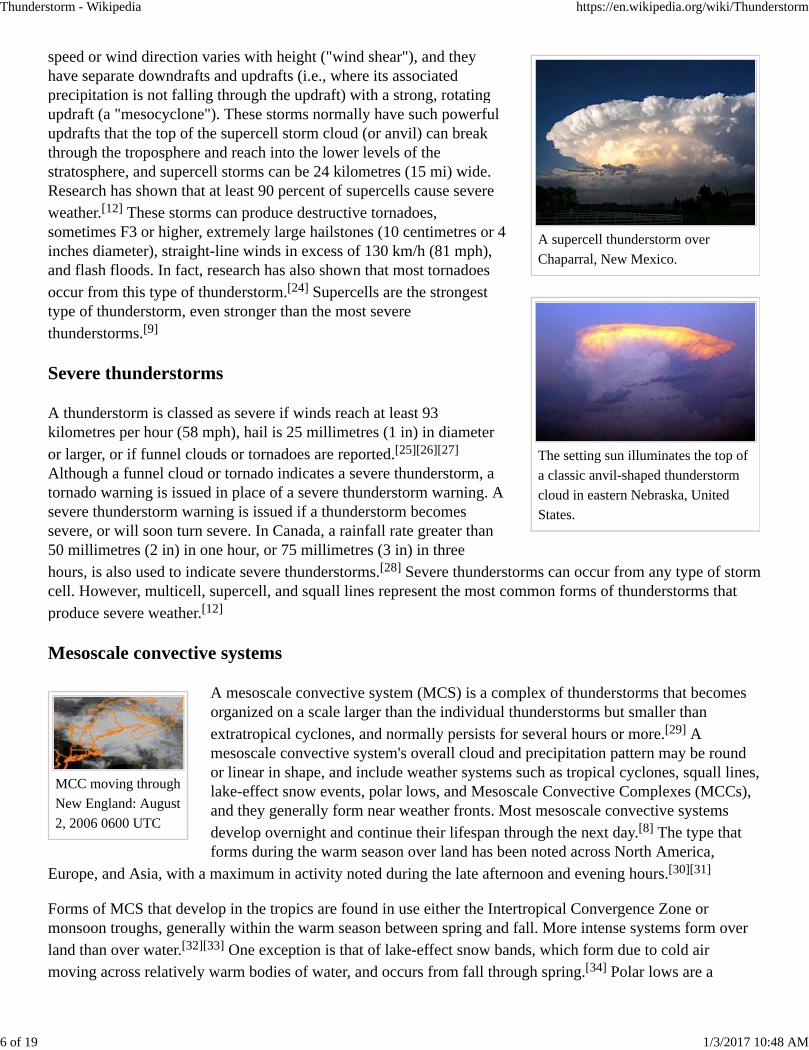
A supercell thunderstorm over
Chaparral, New Mexico.
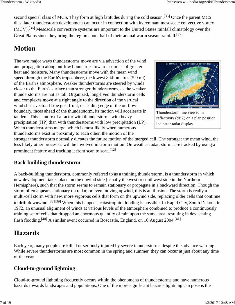
The setting sun illuminates the top of
a classic anvil-shaped thunderstorm
cloud in eastern Nebraska, United
States.
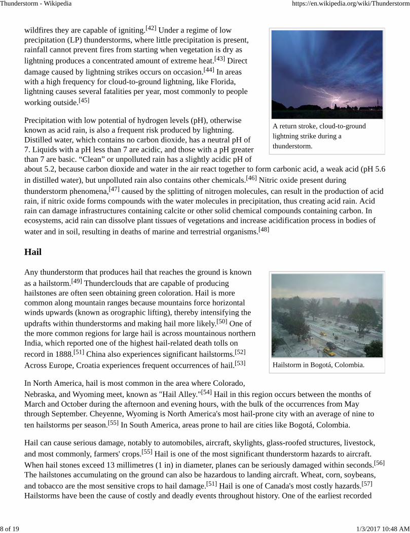
MCC moving through
New England: August
2, 2006 0600 UTC
speed or wind direction varies with height ("wind shear"), and theyhave separate downdrafts and updrafts (i.e., where its associatedprecipitation is not falling through the updraft) with a strong, rotatingupdraft (a "mesocyclone"). These storms normally have such powerfulupdrafts that the top of the supercell storm cloud (or anvil) can breakthrough the troposphere and reach into the lower levels of thestratosphere, and supercell storms can be 24 kilometres (15 mi) wide.Research has shown that at least 90 percent of supercells cause severeweather.[12] These storms can produce destructive tornadoes,sometimes F3 or higher, extremely large hailstones (10 centimetres or 4inches diameter), straight-line winds in excess of 130 km/h (81 mph),and flash floods. In fact, research has also shown that most tornadoesoccur from this type of thunderstorm.[24] Supercells are the strongesttype of thunderstorm, even stronger than the most severethunderstorms.[9]
Severe thunderstorms
A thunderstorm is classed as severe if winds reach at least 93kilometres per hour (58 mph), hail is 25 millimetres (1 in) in diameteror larger, or if funnel clouds or tornadoes are reported.[25][26][27]
Although a funnel cloud or tornado indicates a severe thunderstorm, atornado warning is issued in place of a severe thunderstorm warning. Asevere thunderstorm warning is issued if a thunderstorm becomessevere, or will soon turn severe. In Canada, a rainfall rate greater than50 millimetres (2 in) in one hour, or 75 millimetres (3 in) in threehours, is also used to indicate severe thunderstorms.[28] Severe thunderstorms can occur from any type of stormcell. However, multicell, supercell, and squall lines represent the most common forms of thunderstorms thatproduce severe weather.[12]
Mesoscale convective systems
A mesoscale convective system (MCS) is a complex of thunderstorms that becomesorganized on a scale larger than the individual thunderstorms but smaller thanextratropical cyclones, and normally persists for several hours or more.[29] Amesoscale convective system's overall cloud and precipitation pattern may be roundor linear in shape, and include weather systems such as tropical cyclones, squall lines,lake-effect snow events, polar lows, and Mesoscale Convective Complexes (MCCs),and they generally form near weather fronts. Most mesoscale convective systemsdevelop overnight and continue their lifespan through the next day.[8] The type thatforms during the warm season over land has been noted across North America,
Europe, and Asia, with a maximum in activity noted during the late afternoon and evening hours.[30][31]
Forms of MCS that develop in the tropics are found in use either the Intertropical Convergence Zone ormonsoon troughs, generally within the warm season between spring and fall. More intense systems form overland than over water.[32][33] One exception is that of lake-effect snow bands, which form due to cold airmoving across relatively warm bodies of water, and occurs from fall through spring.[34] Polar lows are a
Thunderstorm - Wikipedia https://en.wikipedia.org/wiki/Thunderstorm
6 of 19 1/3/2017 10:48 AM
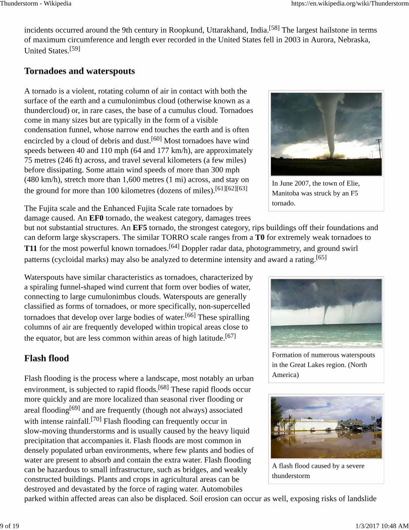
Thunderstorm line viewed in
reflectivity (dBZ) on a plan position
indicator radar display
second special class of MCS. They form at high latitudes during the cold season.[35] Once the parent MCSdies, later thunderstorm development can occur in connection with its remnant mesoscale convective vortex(MCV).[36] Mesoscale convective systems are important to the United States rainfall climatology over theGreat Plains since they bring the region about half of their annual warm season rainfall.[37]
The two major ways thunderstorms move are via advection of the windand propagation along outflow boundaries towards sources of greaterheat and moisture. Many thunderstorms move with the mean windspeed through the Earth's troposphere, the lowest 8 kilometres (5.0 mi)of the Earth's atmosphere. Weaker thunderstorms are steered by windscloser to the Earth's surface than stronger thunderstorms, as the weakerthunderstorms are not as tall. Organized, long-lived thunderstorm cellsand complexes move at a right angle to the direction of the verticalwind shear vector. If the gust front, or leading edge of the outflowboundary, races ahead of the thunderstorm, its motion will accelerate intandem. This is more of a factor with thunderstorms with heavyprecipitation (HP) than with thunderstorms with low precipitation (LP).When thunderstorms merge, which is most likely when numerousthunderstorms exist in proximity to each other, the motion of thestronger thunderstorm normally dictates the future motion of the merged cell. The stronger the mean wind, theless likely other processes will be involved in storm motion. On weather radar, storms are tracked by using aprominent feature and tracking it from scan to scan.[12]
Back-building thunderstorm
A back-building thunderstorm, commonly referred to as a training thunderstorm, is a thunderstorm in whichnew development takes place on the upwind side (usually the west or southwest side in the NorthernHemisphere), such that the storm seems to remain stationary or propagate in a backward direction. Though thestorm often appears stationary on radar, or even moving upwind, this is an illusion. The storm is really amulti-cell storm with new, more vigorous cells that form on the upwind side, replacing older cells that continueto drift downwind.[38][39] When this happens, catastrophic flooding is possible. In Rapid City, South Dakota, in1972, an unusual alignment of winds at various levels of the atmosphere combined to produce a continuouslytraining set of cells that dropped an enormous quantity of rain upon the same area, resulting in devastatingflash flooding.[40] A similar event occurred in Boscastle, England, on 16 August 2004.[41]
Each year, many people are killed or seriously injured by severe thunderstorms despite the advance warning.While severe thunderstorms are most common in the spring and summer, they can occur at just about any timeof the year.
Cloud-to-ground lightning
Cloud-to-ground lightning frequently occurs within the phenomena of thunderstorms and have numeroushazards towards landscapes and populations. One of the more significant hazards lightning can pose is the
Thunderstorm - Wikipedia https://en.wikipedia.org/wiki/Thunderstorm
7 of 19 1/3/2017 10:48 AM
A return stroke, cloud-to-ground
lightning strike during a
thunderstorm.
Hailstorm in Bogotá, Colombia.
wildfires they are capable of igniting.[42] Under a regime of lowprecipitation (LP) thunderstorms, where little precipitation is present,rainfall cannot prevent fires from starting when vegetation is dry aslightning produces a concentrated amount of extreme heat.[43] Directdamage caused by lightning strikes occurs on occasion.[44] In areaswith a high frequency for cloud-to-ground lightning, like Florida,lightning causes several fatalities per year, most commonly to peopleworking outside.[45]
Precipitation with low potential of hydrogen levels (pH), otherwiseknown as acid rain, is also a frequent risk produced by lightning.Distilled water, which contains no carbon dioxide, has a neutral pH of7. Liquids with a pH less than 7 are acidic, and those with a pH greaterthan 7 are basic. “Clean” or unpolluted rain has a slightly acidic pH ofabout 5.2, because carbon dioxide and water in the air react together to form carbonic acid, a weak acid (pH 5.6in distilled water), but unpolluted rain also contains other chemicals.[46] Nitric oxide present duringthunderstorm phenomena,[47] caused by the splitting of nitrogen molecules, can result in the production of acidrain, if nitric oxide forms compounds with the water molecules in precipitation, thus creating acid rain. Acidrain can damage infrastructures containing calcite or other solid chemical compounds containing carbon. Inecosystems, acid rain can dissolve plant tissues of vegetations and increase acidification process in bodies ofwater and in soil, resulting in deaths of marine and terrestrial organisms.[48]
Hail
Any thunderstorm that produces hail that reaches the ground is knownas a hailstorm.[49] Thunderclouds that are capable of producinghailstones are often seen obtaining green coloration. Hail is morecommon along mountain ranges because mountains force horizontalwinds upwards (known as orographic lifting), thereby intensifying theupdrafts within thunderstorms and making hail more likely.[50] One ofthe more common regions for large hail is across mountainous northernIndia, which reported one of the highest hail-related death tolls onrecord in 1888.[51] China also experiences significant hailstorms.[52]
Across Europe, Croatia experiences frequent occurrences of hail.[53]
In North America, hail is most common in the area where Colorado,Nebraska, and Wyoming meet, known as "Hail Alley."[54] Hail in this region occurs between the months ofMarch and October during the afternoon and evening hours, with the bulk of the occurrences from Maythrough September. Cheyenne, Wyoming is North America's most hail-prone city with an average of nine toten hailstorms per season.[55] In South America, areas prone to hail are cities like Bogotá, Colombia.
Hail can cause serious damage, notably to automobiles, aircraft, skylights, glass-roofed structures, livestock,and most commonly, farmers' crops.[55] Hail is one of the most significant thunderstorm hazards to aircraft.When hail stones exceed 13 millimetres (1 in) in diameter, planes can be seriously damaged within seconds.[56]
The hailstones accumulating on the ground can also be hazardous to landing aircraft. Wheat, corn, soybeans,and tobacco are the most sensitive crops to hail damage.[51] Hail is one of Canada's most costly hazards.[57]
Hailstorms have been the cause of costly and deadly events throughout history. One of the earliest recorded
Thunderstorm - Wikipedia https://en.wikipedia.org/wiki/Thunderstorm
8 of 19 1/3/2017 10:48 AM
In June 2007, the town of Elie,
Manitoba was struck by an F5
tornado.
Formation of numerous waterspouts
in the Great Lakes region. (North
America)
A flash flood caused by a severe
thunderstorm
incidents occurred around the 9th century in Roopkund, Uttarakhand, India.[58] The largest hailstone in termsof maximum circumference and length ever recorded in the United States fell in 2003 in Aurora, Nebraska,United States.[59]
Tornadoes and waterspouts
A tornado is a violent, rotating column of air in contact with both thesurface of the earth and a cumulonimbus cloud (otherwise known as athundercloud) or, in rare cases, the base of a cumulus cloud. Tornadoescome in many sizes but are typically in the form of a visiblecondensation funnel, whose narrow end touches the earth and is oftenencircled by a cloud of debris and dust.[60] Most tornadoes have windspeeds between 40 and 110 mph (64 and 177 km/h), are approximately75 metres (246 ft) across, and travel several kilometers (a few miles)before dissipating. Some attain wind speeds of more than 300 mph(480 km/h), stretch more than 1,600 metres (1 mi) across, and stay onthe ground for more than 100 kilometres (dozens of miles).[61][62][63]
The Fujita scale and the Enhanced Fujita Scale rate tornadoes bydamage caused. An EF0 tornado, the weakest category, damages treesbut not substantial structures. An EF5 tornado, the strongest category, rips buildings off their foundations andcan deform large skyscrapers. The similar TORRO scale ranges from a T0 for extremely weak tornadoes toT11 for the most powerful known tornadoes.[64] Doppler radar data, photogrammetry, and ground swirlpatterns (cycloidal marks) may also be analyzed to determine intensity and award a rating.[65]
Waterspouts have similar characteristics as tornadoes, characterized bya spiraling funnel-shaped wind current that form over bodies of water,connecting to large cumulonimbus clouds. Waterspouts are generallyclassified as forms of tornadoes, or more specifically, non-supercelledtornadoes that develop over large bodies of water.[66] These spirallingcolumns of air are frequently developed within tropical areas close tothe equator, but are less common within areas of high latitude.[67]
Flash flood
Flash flooding is the process where a landscape, most notably an urbanenvironment, is subjected to rapid floods.[68] These rapid floods occurmore quickly and are more localized than seasonal river flooding orareal flooding[69] and are frequently (though not always) associatedwith intense rainfall.[70] Flash flooding can frequently occur inslow-moving thunderstorms and is usually caused by the heavy liquidprecipitation that accompanies it. Flash floods are most common indensely populated urban environments, where few plants and bodies ofwater are present to absorb and contain the extra water. Flash floodingcan be hazardous to small infrastructure, such as bridges, and weaklyconstructed buildings. Plants and crops in agricultural areas can bedestroyed and devastated by the force of raging water. Automobilesparked within affected areas can also be displaced. Soil erosion can occur as well, exposing risks of landslide
Thunderstorm - Wikipedia https://en.wikipedia.org/wiki/Thunderstorm
9 of 19 1/3/2017 10:48 AM
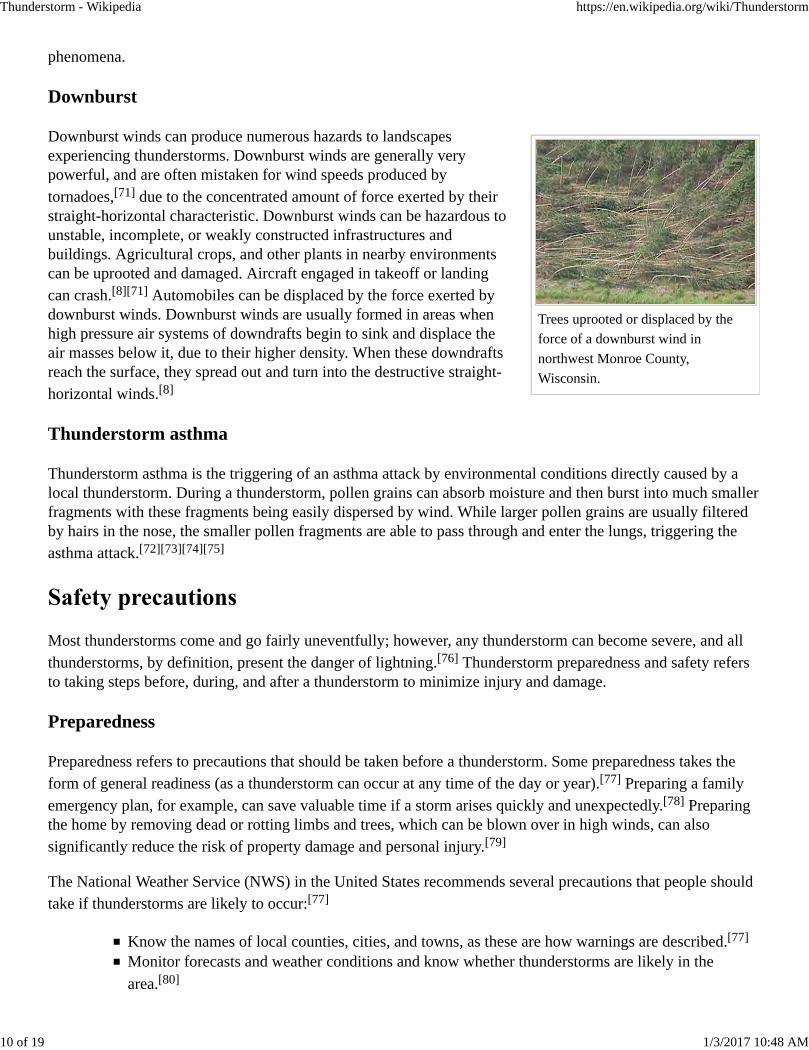
Trees uprooted or displaced by the
force of a downburst wind in
northwest Monroe County,
Wisconsin.
phenomena.
Downburst
Downburst winds can produce numerous hazards to landscapesexperiencing thunderstorms. Downburst winds are generally verypowerful, and are often mistaken for wind speeds produced bytornadoes,[71] due to the concentrated amount of force exerted by theirstraight-horizontal characteristic. Downburst winds can be hazardous tounstable, incomplete, or weakly constructed infrastructures andbuildings. Agricultural crops, and other plants in nearby environmentscan be uprooted and damaged. Aircraft engaged in takeoff or landingcan crash.[8][71] Automobiles can be displaced by the force exerted bydownburst winds. Downburst winds are usually formed in areas whenhigh pressure air systems of downdrafts begin to sink and displace theair masses below it, due to their higher density. When these downdraftsreach the surface, they spread out and turn into the destructive straight-horizontal winds.[8]
Thunderstorm asthma
Thunderstorm asthma is the triggering of an asthma attack by environmental conditions directly caused by alocal thunderstorm. During a thunderstorm, pollen grains can absorb moisture and then burst into much smallerfragments with these fragments being easily dispersed by wind. While larger pollen grains are usually filteredby hairs in the nose, the smaller pollen fragments are able to pass through and enter the lungs, triggering theasthma attack.[72][73][74][75]
Most thunderstorms come and go fairly uneventfully; however, any thunderstorm can become severe, and allthunderstorms, by definition, present the danger of lightning.[76] Thunderstorm preparedness and safety refersto taking steps before, during, and after a thunderstorm to minimize injury and damage.
Preparedness
Preparedness refers to precautions that should be taken before a thunderstorm. Some preparedness takes theform of general readiness (as a thunderstorm can occur at any time of the day or year).[77] Preparing a familyemergency plan, for example, can save valuable time if a storm arises quickly and unexpectedly.[78] Preparingthe home by removing dead or rotting limbs and trees, which can be blown over in high winds, can alsosignificantly reduce the risk of property damage and personal injury.[79]
The National Weather Service (NWS) in the United States recommends several precautions that people shouldtake if thunderstorms are likely to occur:[77]
Know the names of local counties, cities, and towns, as these are how warnings are described.[77]
Monitor forecasts and weather conditions and know whether thunderstorms are likely in the
area.[80]
Thunderstorm - Wikipedia https://en.wikipedia.org/wiki/Thunderstorm
10 of 19 1/3/2017 10:48 AM
Be alert for natural signs of an approaching storm.
Cancel or reschedule outdoor events (to avoid being caught outdoors when a storm hits).[80]
Take action early so you have time to get to a safe place.[80]
Get inside a substantial building or hard-topped metal vehicle before threatening weather
arrives.[80]
If you hear thunder, get to the safe place immediately.[80]
Avoid open areas like hilltops, fields, and beaches, and don't be or be near the tallest objects in an
area when thunderstorms are occurring.[77][80]
Don't shelter under tall or isolated trees during thunderstorms.[80]
If in the woods, put as much distance between you and any trees during thunderstorms.[80]
If in a group, spread out so that you increase the chances for survivors who could come to the aid
of any victims from a lightning strike.[80]
Safety
While safety and preparedness often overlap, “thunderstorm safety” generally refers to what people should doduring and after a storm. The American Red Cross recommends that people follow these precautions if a stormis imminent or in progress:[76]
Take action immediately upon hearing thunder. Anyone close enough to the storm to hear thunder
can be struck by lightning.[79]
Avoid electrical appliances, including corded telephones.[76] Cordless and wireless telephones are
safe to use during a thunderstorm.[79]
Close and stay away from windows and doors, as glass can become a serious hazard in high
wind.[76]
Do not bathe or shower, as plumbing conducts electricity.If driving, safely exit the roadway, turn on hazard lights, and park. Remain in the vehicle and
avoid touching metal.[76]
The NWS stopped recommending the "lightning crouch" in 2008 as it doesn't provide a significant level ofprotection and will not significantly lower the risk of being killed or injured from a nearby lightning strike.[80][81][82]
Thunderstorms occur throughout the world, even in the polar regions, with the greatest frequency in tropicalrainforest areas, where they may occur nearly daily. At any given time approximately 2,000 thunderstorms areoccurring on Earth.[83] Kampala and Tororo in Uganda have each been mentioned as the most thunderousplaces on Earth,[84] a claim also made for Bogor on Java, Indonesia and Singapore. Other cities known forfrequent storm activity include Darwin, Caracas, Manila and Mumbai. Thunderstorms are associated with thevarious monsoon seasons around the globe, and they populate the rainbands of tropical cyclones.[85] Intemperate regions, they are most frequent in spring and summer, although they can occur along or ahead ofcold fronts at any time of year.[86] They may also occur within a cooler air mass following the passage of acold front over a relatively warmer body of water. Thunderstorms are rare in polar regions because of coldsurface temperatures.
Thunderstorm - Wikipedia https://en.wikipedia.org/wiki/Thunderstorm
11 of 19 1/3/2017 10:48 AM
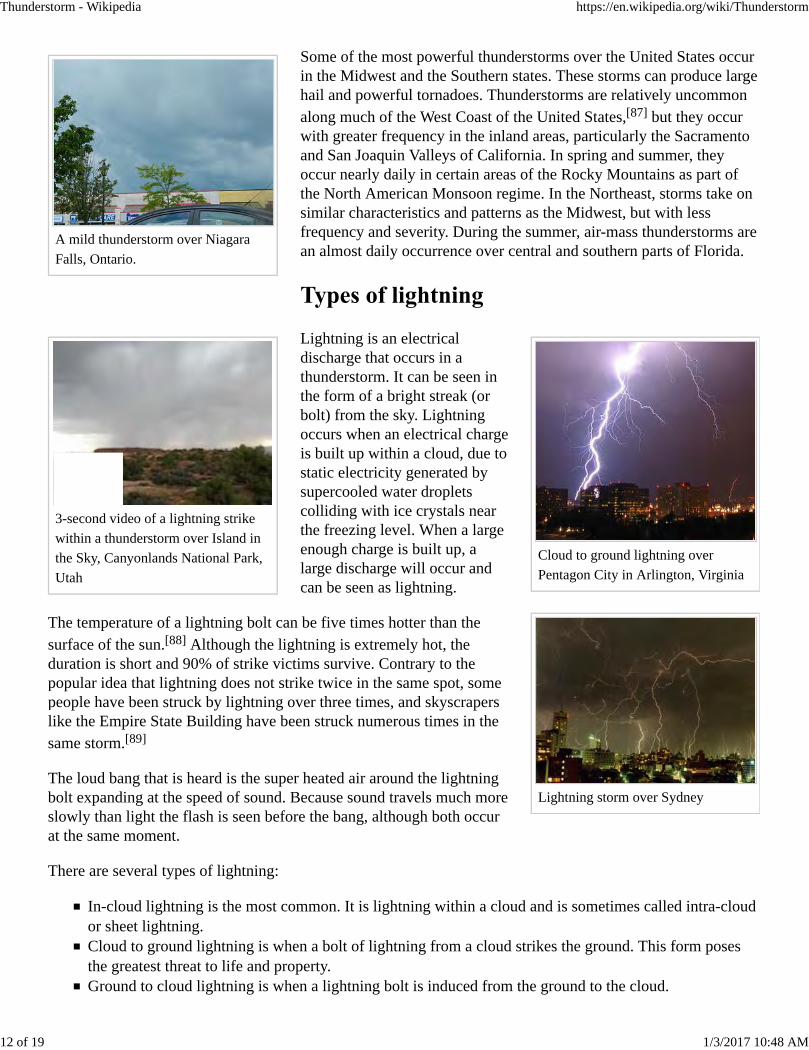
A mild thunderstorm over Niagara
Falls, Ontario.
3-second video of a lightning strike
within a thunderstorm over Island in
the Sky, Canyonlands National Park,
Utah
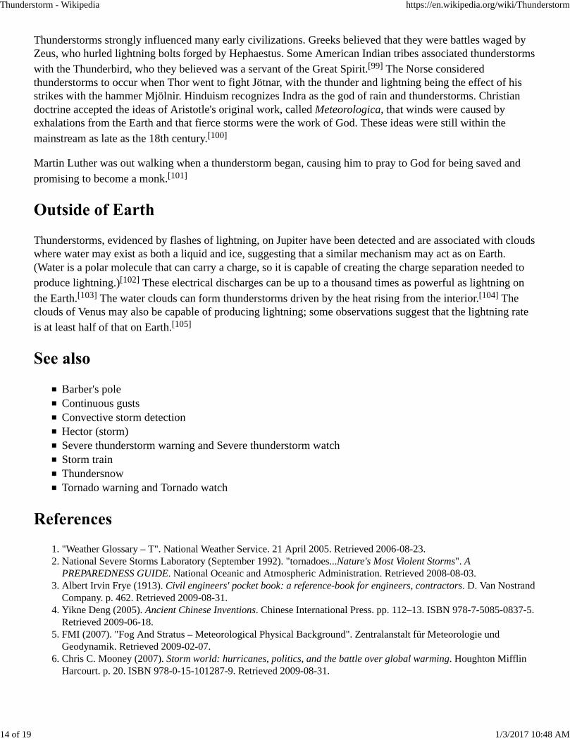
Cloud to ground lightning over
Pentagon City in Arlington, Virginia
Lightning storm over Sydney
Some of the most powerful thunderstorms over the United States occurin the Midwest and the Southern states. These storms can produce largehail and powerful tornadoes. Thunderstorms are relatively uncommonalong much of the West Coast of the United States,[87] but they occurwith greater frequency in the inland areas, particularly the Sacramentoand San Joaquin Valleys of California. In spring and summer, theyoccur nearly daily in certain areas of the Rocky Mountains as part ofthe North American Monsoon regime. In the Northeast, storms take onsimilar characteristics and patterns as the Midwest, but with lessfrequency and severity. During the summer, air-mass thunderstorms arean almost daily occurrence over central and southern parts of Florida.
Lightning is an electricaldischarge that occurs in athunderstorm. It can be seen inthe form of a bright streak (orbolt) from the sky. Lightningoccurs when an electrical chargeis built up within a cloud, due tostatic electricity generated bysupercooled water dropletscolliding with ice crystals nearthe freezing level. When a largeenough charge is built up, alarge discharge will occur andcan be seen as lightning.
The temperature of a lightning bolt can be five times hotter than thesurface of the sun.[88] Although the lightning is extremely hot, theduration is short and 90% of strike victims survive. Contrary to thepopular idea that lightning does not strike twice in the same spot, somepeople have been struck by lightning over three times, and skyscraperslike the Empire State Building have been struck numerous times in thesame storm.[89]
The loud bang that is heard is the super heated air around the lightningbolt expanding at the speed of sound. Because sound travels much moreslowly than light the flash is seen before the bang, although both occurat the same moment.
There are several types of lightning:
In-cloud lightning is the most common. It is lightning within a cloud and is sometimes called intra-cloudor sheet lightning.Cloud to ground lightning is when a bolt of lightning from a cloud strikes the ground. This form posesthe greatest threat to life and property.Ground to cloud lightning is when a lightning bolt is induced from the ground to the cloud.
Thunderstorm - Wikipedia https://en.wikipedia.org/wiki/Thunderstorm
12 of 19 1/3/2017 10:48 AM

How thunderstorms launch particle
beams into space
Cloud to cloud lightning is rarely seen and is when a bolt of lightning arcs from one cloud to another.Ball lightning is extremely rare and has several hypothesized explanations. It is seen in the form of a 15
to 50 centimeter radius ball.[90]
Cloud to air lightning is when lightning from a cloud hits air of a different charge.[91]
Dry lightning is a misnomer that refers to a thunderstorm whose precipitation does not reach the ground.Heat Lightning refers to a lightning flash that is seen from the horizon that does not have accompanying
thunder.[92]
Upper-atmospheric lightning occurs above the thunderhead.Clear-air lightning is used widely to describe lightning that occurs with no apparent cloud close enoughto have produced it. In the U.S. and Canadian Rockies, a thunderstorm can be in an adjacent valley andnot be observable, (either visually or audibly), from the valley where the lightning bolt strikes. Europeanand Asian mountainous areas experience similar events. Also in clear areas where the storm cell is on thenear horizon (within 26 km (16 mi) a strike can occur, and as the storm is so far away, the strike isreferred to as clear-air.
If the quantity of water that is condensed in and subsequentlyprecipitated from a cloud is known, then the total energy of athunderstorm can be calculated. In a typical thunderstorm,approximately 5×10⁸ kg of water vapor are lifted, and the amount ofenergy released when this condenses is 1015 joules. This is on the sameorder of magnitude of energy released within a tropical cyclone, andmore energy than that released during the atomic bomb blast atHiroshima, Japan in 1945.[10]
The Fermi Gamma-ray Burst Monitor results show that gamma raysand antimatter particles (positrons) can be generated in powerfulthunderstorms.[93] It is suggested that the antimatter positrons areformed in terrestrial gamma-ray flashes (TGF). TGFs are brief bursts occurring inside thunderstorms andassociated with lightning. The streams of positrons and electrons collide higher in the atmosphere to generatemore gamma rays.[94] About 500 TGFs may occur every day worldwide, but mostly go undetected.
In more contemporary times, thunderstorms have taken on the role of a scientific curiosity. Every spring, stormchasers head to the Great Plains of the United States and the Canadian Prairies to explore the scientific aspectsof storms and tornadoes through use of videotaping.[95] Radio pulses produced by cosmic rays are being usedto study how electric charges develop within thunderstorms.[96] More organized meteorological projects suchas VORTEX2 use an array of sensors, such as the Doppler on Wheels, vehicles with mounted automatedweather stations, weather balloons, and unmanned aircraft to investigate thunderstorms expected to producesevere weather.[97] Lightning is detected remotely using sensors that detect cloud-to-ground lightning strokeswith 95 percent accuracy in detection and within 250 metres (820 ft) of their point of origin.[98]
Thunderstorm - Wikipedia https://en.wikipedia.org/wiki/Thunderstorm
13 of 19 1/3/2017 10:48 AM
Thunderstorms strongly influenced many early civilizations. Greeks believed that they were battles waged byZeus, who hurled lightning bolts forged by Hephaestus. Some American Indian tribes associated thunderstormswith the Thunderbird, who they believed was a servant of the Great Spirit.[99] The Norse consideredthunderstorms to occur when Thor went to fight Jötnar, with the thunder and lightning being the effect of hisstrikes with the hammer Mjölnir. Hinduism recognizes Indra as the god of rain and thunderstorms. Christiandoctrine accepted the ideas of Aristotle's original work, called Meteorologica, that winds were caused byexhalations from the Earth and that fierce storms were the work of God. These ideas were still within themainstream as late as the 18th century.[100]
Martin Luther was out walking when a thunderstorm began, causing him to pray to God for being saved andpromising to become a monk.[101]
Thunderstorms, evidenced by flashes of lightning, on Jupiter have been detected and are associated with cloudswhere water may exist as both a liquid and ice, suggesting that a similar mechanism may act as on Earth.(Water is a polar molecule that can carry a charge, so it is capable of creating the charge separation needed toproduce lightning.)[102] These electrical discharges can be up to a thousand times as powerful as lightning onthe Earth.[103] The water clouds can form thunderstorms driven by the heat rising from the interior.[104] Theclouds of Venus may also be capable of producing lightning; some observations suggest that the lightning rateis at least half of that on Earth.[105]
Barber's poleContinuous gustsConvective storm detectionHector (storm)Severe thunderstorm warning and Severe thunderstorm watchStorm trainThundersnowTornado warning and Tornado watch
"Weather Glossary – T". National Weather Service. 21 April 2005. Retrieved 2006-08-23.1. National Severe Storms Laboratory (September 1992). "tornadoes...Nature's Most Violent Storms". APREPAREDNESS GUIDE. National Oceanic and Atmospheric Administration. Retrieved 2008-08-03.
2.
Albert Irvin Frye (1913). Civil engineers' pocket book: a reference-book for engineers, contractors. D. Van NostrandCompany. p. 462. Retrieved 2009-08-31.
3.
Yikne Deng (2005). Ancient Chinese Inventions. Chinese International Press. pp. 112–13. ISBN 978-7-5085-0837-5.Retrieved 2009-06-18.
4.
FMI (2007). "Fog And Stratus – Meteorological Physical Background". Zentralanstalt für Meteorologie undGeodynamik. Retrieved 2009-02-07.
5.
Chris C. Mooney (2007). Storm world: hurricanes, politics, and the battle over global warming. Houghton MifflinHarcourt. p. 20. ISBN 978-0-15-101287-9. Retrieved 2009-08-31.
6.
Thunderstorm - Wikipedia https://en.wikipedia.org/wiki/Thunderstorm
14 of 19 1/3/2017 10:48 AM
David O. Blanchard (September 1998). "Assessing the Vertical Distribution of Convective Available PotentialEnergy". Weather and Forecasting. American Meteorological Society. 13 (3): 870–7.Bibcode:1998WtFor..13..870B. doi:10.1175/1520-0434(1998)013<0870:ATVDOC>2.0.CO;2.
7.
Michael H. Mogil (2007). Extreme Weather. New York: Black Dog & Leventhal Publisher. pp. 210–211.ISBN 978-1-57912-743-5.
8.
National Severe Storms Laboratory (2006-10-15). "A Severe Weather Primer: Questions and Answers aboutThunderstorms". National Oceanic and Atmospheric Administration. Retrieved 2009-09-01.
9.
Gianfranco Vidali (2009). "Rough Values of Various Processes". University of Syracuse. Retrieved 2009-08-31.10. Pilot's Web The Aviator's Journal (2009-06-13). "Structural Icing in VMC". Retrieved 2009-09-02.11. Jon W. Zeitler & Matthew J. Bunkers (March 2005). "Operational Forecasting of Supercell Motion: Review andCase Studies Using Multiple Datasets" (PDF). National Weather Service Forecast Office, Riverton, Wyoming.Retrieved 2009-08-30.
12.
The Weather World 2010 Project (2009-09-03). "Vertical Wind Shear". University of Illinois. Retrieved 2006-10-21.13. T. T. Fujita (1985). The Downburst, microburst and macroburst: SMRP Research Paper 210.14. Glossary of Meteorology (2009). "Squall line". American Meteorological Society. Retrieved 2009-06-14.15. Glossary of Meteorology (2009). "Prefrontal squall line". American Meteorological Society. Retrieved 2009-06-14.16. University of Oklahoma (2004). "The Norwegian Cyclone Model" (PDF). Archived from the original (PDF) onSeptember 1, 2006. Retrieved 2007-05-17.
17.
Office of the Federal Coordinator for Meteorology (2008). "Chapter 2: Definitions" (PDF). NOAA. pp. 2–1.Retrieved 2009-05-03.
18.
Glossary of Meteorology (2009). "Bow echo". American Meteorological Society. Retrieved 2009-06-14.19. Glossary of Meteorology (2009). Line echo wave pattern. American Meteorological Society. ISBN 1-878220-34-9.Retrieved 2009-05-03.
20.
Stephen F. Corfidi; Jeffry S. Evans & Robert H. Johns (2015). "About Derechos". Storm Prediction Center, NCEP,NWS, NOAA Web Site. Retrieved 2015-02-17.
21.
Glossary of Meteorology (2009). Heat burst. American Meteorological Society. ISBN 1-878220-34-9. Retrieved2009-06-14.
22.
"Squall lines and "Shi Hu Feng" – what you want to know about the violent squalls hitting Hong Kong on 9 May2005". Hong Kong Observatory. 17 June 2005. Retrieved 2006-08-23.
23.
"Supercell Thunderstorms". Weather World 2010 Project. University of Illinois. October 4, 1999. Retrieved2006-08-23.
24.
National Weather Service (2005-04-21). "Weather Glossary – S". National Oceanic and AtmosphericAdministration. Retrieved 2007-06-17.
25.
Kim Runk (2009). 1" Hail (.wmv). Silver Spring, Maryland: NOAA.26. National Weather Service Forecast Office, Phoenix, Arizona (2009-04-07). "New Hail Criteria". Retrieved2009-09-03.
27.
Environment Canada Ontario Region (2005-05-24). "Fact Sheet – Summer Severe Weather Warnings". Retrieved2009-09-03.
28.
Glossary of Meteorology (2009). "Mesoscale convective system". American Meteorological Society. Retrieved2009-06-27.
29.
William R. Cotton; Susan van den Heever & Israel Jirak (2003). "Conceptual Models of Mesoscale ConvectiveSystems: Part 9" (PDF). Colorado State University. Retrieved 2008-03-23.
30.
C. Morel & S. Senesi (2002). "A climatology of mesoscale convective systems over Europe using satellite infraredimagery II: Characteristics of European mesoscale convective systems". Quarterly Journal of the RoyalMeteorological Society. 128 (584): 1973. Bibcode:2002QJRMS.128.1973M. doi:10.1256/003590002320603494.ISSN 0035-9009. Retrieved 2008-03-02.
31.
Semyon A. Grodsky & James A. Carton (2003-02-15). "The Intertropical Convergence Zone in the South Atlanticand the Equatorial Cold Tongue" (PDF). University of Maryland, College Park. Retrieved 2009-06-05.
32.
Michael Garstang; David Roy Fitzjarrald (1999). Observations of surface to atmosphere interactions in the tropics.Oxford University Press US. pp. 40–41. ISBN 978-0-19-511270-2.
33.
B. Geerts (1998). "Lake Effect Snow". University of Wyoming. Retrieved 2008-12-24.34. E. A. Rasmussen & J. Turner (2003). Polar Lows: Mesoscale Weather Systems in the Polar Regions. CambridgeUniversity Press. p. 612. ISBN 978-0-521-62430-5.
35.
Thunderstorm - Wikipedia https://en.wikipedia.org/wiki/Thunderstorm
15 of 19 1/3/2017 10:48 AM
Lance F. Bosart & Thomas J. Galarneau, Jr. (2005). "3.5 The Influence of the Great Lakes on Warm Season WeatherSystems During BAMEX" (PDF). 6th American Meteorological Society Coastal Meteorology Conference. Retrieved2009-06-15.
36.
William R. Cotton; Susan van den Heever & Israel Jirak (Fall 2003). "Conceptual Models of Mesoscale ConvectiveSystems: Part 9" (PDF). Retrieved 2008-03-23.
37.
Stephen Corfidi (2015-02-04). "MCS Movement and Behavior (PowerPoint)". National Weather Service, StormPrediction Center. Retrieved 2015-02-18.
38.
National Weather Service (2009-09-01). "Types of Thunderstorms". National Weather Service Southern RegionHeadquarters. Retrieved 2009-09-03.
39.
National Weather Service Forecast Office, Rapid City, South Dakota (2007-05-15). "The Rapid City Flood of 1972".National Weather Service Central Region Headquarters. Retrieved 2009-09-03.
40.
David Flower (2008-02-09). "Boscastle Flood 2004". Tintagel – King Arthur Country. Retrieved 2009-09-03.41. Scott, A (2000). "The Pre-Quaternary history of fire". Palaeogeography Palaeoclimatology Palaeoecology. 164:281. doi:10.1016/S0031-0182(00)00192-9.
42.
Vladimir A. Rakov (1999). "Lightning Makes Glass". University of Florida, Gainesville. Retrieved November 7,2007.
43.
Bruce Getz & Kelli Bowermeister (2009-01-09). "Lightning and Its Hazards". Hughston Sports MedicineFoundation. Retrieved 2009-09-09.
44.
Charles H. Paxton; J. Colson & N. Carlisle (2008). "P2.13 Florida lightning deaths and injuries 2004–2007".American Meteorological Society. Retrieved 2009-09-05.
45.
G. E. Likens; W. C. Keene; J. M. Miller & J. N. Galloway (1987). "Chemistry of precipitation from a remote,terrestrial site in Australia". Journal of Geophysical Research. 92 (13): 299–314. Bibcode:1987JGR....92..299R.doi:10.1029/JA092iA01p00299.
46.
Joel S. Levine; Tommy R. Augustsson; Iris C. Andersont; James M. Hoell Jr. & Dana A. Brewer (1984)."Tropospheric sources of NOx: Lightning and biology". Atmospheric Environment. 18 (9): 1797–1804.Bibcode:1984AtmEn..18.1797L. doi:10.1016/0004-6981(84)90355-X. PMID 11540827.
47.
Office of Air and Radiation Clean Air Markets Division (2008-12-01). "Effects of Acid Rain – Surface Waters andown Aquatic Animals". United States Environmental Protection Agency. Retrieved 2009-09-05.
48.
Glossary of Meteorology (2009). "Hailstorm". American Meteorological Society. Retrieved 2009-08-29.49. Geoscience Australia (2007-09-04). "Where does severe weather occur?". Commonwealth of Australia. Archivedfrom the original on 2009-06-21. Retrieved 2009-08-28.
50.
John E. Oliver (2005). Encyclopedia of World Climatology. Springer. p. 401. ISBN 978-1-4020-3264-6. Retrieved2009-08-28.
51.
Dongxia Liu; Guili Feng & Shujun Wu (February 2009). "The characteristics of cloud-to-ground lightning activityin hailstorms over northern China". Atmospheric Research. 91 (2–4): 459–465. Bibcode:2009AtmRe..91..459L.doi:10.1016/j.atmosres.2008.06.016.
52.
Damir Počakal; Željko Večenaj & Janez Štalec (2009). "Hail characteristics of different regions in continental part ofCroatia based on influence of orography". Atmospheric Research. 93 (1–3): 516. Bibcode:2009AtmRe..93..516P.doi:10.1016/j.atmosres.2008.10.017.
53.
Rene Munoz (2000-06-02). "Fact Sheet on Hail". University Corporation for Atmospheric Research. Retrieved2009-07-18.
54.
Nolan J. Doesken (April 1994). "Hail, Hail, Hail ! The Summertime Hazard of Eastern Colorado" (PDF). ColoradoClimate. 17 (7). Retrieved 2009-07-18.
55.
Federal Aviation Administration (2009). "Hazards". Retrieved 2009-08-29.56. Damon P. Coppola (2007). Introduction to international disaster management. Butterworth-Heinemann. p. 62.ISBN 978-0-7506-7982-4.
57.
David Orr (2004-11-07). "Giant hail killed more than 200 in Himalayas". Telegraph Group Unlimited via theInternet Wayback Machine. Archived from the original on 2005-12-03. Retrieved 2009-08-28.
58.
C. A. Knight and N.C. Knight, 2005: Very Large Hailstones From Aurora, Nebraska. Bull. Amer. Meteor. Soc., 86,1773–1781.
59.
Renno, Nilton O. (August 2008). "A thermodynamically general theory for convective vortices" (PDF). Tellus A. 60(4): 688–99. Bibcode:2008TellA..60..688R. doi:10.1111/j.1600-0870.2008.00331.x.
60.
Edwards, Roger (2006-04-04). "The Online Tornado FAQ". Storm Prediction Center. Retrieved 2006-09-08.61. "Doppler On Wheels". Center for Severe Weather Research. 2006. Retrieved 2006-12-29.62. "Hallam Nebraska Tornado". Omaha/Valley, NE Weather Forecast Office. 2005-10-02. Retrieved 2006-09-08.63.
Thunderstorm - Wikipedia https://en.wikipedia.org/wiki/Thunderstorm
16 of 19 1/3/2017 10:48 AM
Dr. Terence Meaden (2004). "Wind Scales: Beaufort, T – Scale, and Fujita's Scale". Tornado and Storm ResearchOrganisation. Retrieved 2009-09-11.
64.
Storm Prediction Center. "Enhanced F Scale for Tornado Damage". National Oceanic and AtmosphericAdministration. Retrieved 2009-06-21.
65.
"Waterspout". American Meteorological Society. 2009. Retrieved 2009-09-11.66. National Weather Service Forecast Office, Burlington, Vermont (2009-02-03). "15 January 2009: Lake ChamplainSea Smoke, Steam Devils, and Waterspout: Chapters IV and V". Eastern Region Headquarters. Retrieved2009-06-21.
67.
Glossary of Meteorology (2009). "Flash Flood". American Meteorological Society. Retrieved 2009-09-09.68. National Weather Service. "Flood Products: What Do They Mean?". NOAA. Retrieved 23 August 2011.69. National Weather Service. "Flash Flood". NOAA. Retrieved 23 August 2011.70. National Weather Service Forecast Office Columbia, South Carolina (2009-01-27). "Downbursts...". NationalWeather Service Eastern Region Headquarters. Retrieved 2009-09-09.
71.
Suphioglu C. Thunderstorm Asthma Due to Grass Pollen. Int Arch Allergy Immunol 1998;116:253–260.doi:10.1159/000023953
72.
Taylor, P.E. & Jonsson, H. Thunderstorm asthma. Curr Allergy Asthma Rep (2004) 4: 409.doi:10.1007/s11882-004-0092-3
73.
Dabrera G, Murray V, Emberlin J, Ayres JG, Collier C, Clewlow Y, Sachon P. Thunderstorm asthma: an overview ofthe evidence base and implications for public health advice. QJM. 2013 Mar;106(3):207-17. doi: 10.1093/qjmed/hcs234. PMID 23275386
74.
D'Amato G, Vitale C, D'Amato M, Cecchi L, Liccardi G, Molino A, Vatrella A, Sanduzzi A, Maesano C, Annesi-Maesano I. Thunderstorm-related asthma: what happens and why. Clin Exp Allergy. 2016 Mar;46(3):390-6. doi:10.1111/cea.12709. PMID 26765082
75.
American Red Cross. "Thunderstorm Safety Checklist" (PDF). American Red Cross. Retrieved 24 August 2011.76. National Weather Service Weather Forecast Office. "Thunderstorm". Severe Weather Preparedness Information.Albuquerque, NM: NOAA. Retrieved 24 August 2011.
77.
Federal Emergency Management Agency. "Thunderstorms and Lightning". Ready. US Department of HomelandSecurity. Archived from the original on 23 June 2011. Retrieved 24 August 2011.
78.
Federal Emergency Management Agency. "What to Do Before a Thunderstorm". US Department of HomelandSecurity. Retrieved 24 August 2011.
79.
"NWS Lightning Safety Myths". Lightningsafety.noaa.gov. 2014-06-30. Retrieved 2014-08-20.80. "NWS JetStream – Lightning Frequently Asked Questions". Srh.noaa.gov. 2014-06-28. Retrieved 2014-08-20.81. "You're not safer crouching: Six things you didn't know about lightning". LA Times. Retrieved 2014-08-20.82. National Geographic Almanac of Geography, ISBN 0-7922-3877-X, page 75.83. "How many thunderstorms occur each year?". Thunderstorms. Sky Fire Productions. Retrieved 2006-08-23.84. National Weather Service JetStream (2008-10-08). "Tropical Cyclone Hazards". National Weather Service SouthernRegion Headquarters. Retrieved 2009-08-30.
85.
David Roth. "Unified Surface Analysis Manual" (PDF). Hydrometeorological Prediction Center. Retrieved2006-10-22.
86.
Office of the Federal Coordinator for Meteorology (2001-06-07). "National Severe Local Storms Operations Plan –Chapter 2" (PDF). Department of Commerce. Retrieved 2006-08-23.
87.
Bill Giles O.B.E (2004-09-01). "Lightning". BBC. Archived from the original on March 23, 2008. Retrieved2008-06-29.
88.
Goddard Space Flight Center (2003-01-14). "Lightning really does hit more than twice". National Aeronautics andSpace Administration. Retrieved 2009-09-09.
89.
Glossary of Meteorology (2009). "Ball Lightning". American Meteorological Society. Retrieved 2009-09-09.90. Glossary of Meteorology (2009). "Lightning". American Meteorological Society. Retrieved 2009-09-09.91. Glossary of Meteorology (2009). "Heat Lightning". American Meteorological Society. Retrieved 2009-09-09.92. Garner, Rob (26 June 2015). "Fermi Catches Antimatter-Hurling Storms". nasa.gov. Retrieved 19 July 2016.93. Ouellette, Jennifer (January 13, 2011). "Fermi Spots Antimatter in Thunderstorms". Discovery News. Retrieved16 January 2011.
94.
Alan Moller (2003-03-05). "Storm Chase Ethics". Retrieved 2009-09-09.95. Florida Institute of Technology (2009-06-02). "Scientists use high-energy particles from space to probethunderstorms". Retrieved 2009-09-09.
96.
VORTEX2 (2009). "What is VORTEX2?". Retrieved 2009-09-09.97.
Thunderstorm - Wikipedia https://en.wikipedia.org/wiki/Thunderstorm
17 of 19 1/3/2017 10:48 AM
Peter P. Neilley & R. B. Bent (2009). "An Overview of the United States Precision Lightning Network (USPLN)".American Meteorological Society Fourth Conference on the Meteorological Applications of Lightning Data.Retrieved 2009-09-09.
98.
Obsidian's Lair (2008-06-11). "A Haudenosaunee Pantheon". Corecomm. Retrieved 2009-09-09.99. John D. Cox (2002). Storm Watchers. John Wiley & Sons, Inc. p. 7. ISBN 0-471-38108-X.100. "Martin Luther". Christian History. Retrieved 6 July 2016.101. Elkins-Tanton, Linda T. (2006). Jupiter and Saturn. New York: Chelsea House. ISBN 0-8160-5196-8.102. Watanabe, Susan, ed. (February 25, 2006). "Surprising Jupiter: Busy Galileo spacecraft showed jovian system is fullof surprises". NASA. Retrieved 2007-02-20.
103.
Kerr, Richard A. (2000). "Deep, Moist Heat Drives Jovian Weather". Science. 287 (5455): 946–947.doi:10.1126/science.287.5455.946b. Retrieved 2007-02-24.
104.
Russell, S. T.; Zhang, T.L.; Delva, M.; et al. (2007). "Lightning on Venus inferred from whistler-mode waves in theionosphere". Nature. 450 (7170): 661–662. Bibcode:2007Natur.450..661R. doi:10.1038/nature05930.PMID 18046401.
105.
Burgess, D. W., R. J. Donaldson Jr., and P. R. Desrochers, 1993: Tornado detection and warning byradar. The Tornado: Its Structure, Dynamics, Prediction, and Hazards, Geophys. Monogr., No. 79,American Geophysical Union, 203–221.Corfidi, S. F., 1998: Forecasting MCS mode and motion. Preprints 19th Conf. on Severe Local Storms,American Meteorological Society, Minneapolis, Minnesota, pp. 626–629.Davies, J. M., 2004: Estimations of CIN and LFC associated with tornadic and nontornadic supercells.Weather Forecast., 19, 714–726.Davies, J. M., and R. H. Johns, 1993: Some wind and instability parameters associated with strong andviolent tornadoes. Part I: Helicity and mean shear magnitudes. The Tornado: Its Structure, Dynamics,Prediction, and Hazards (C. Church et al., Eds.), Geophysical Monograph 79, American GeophysicalUnion, 573–582.David, C. L. 1973: An objective of estimating the probability of severe thunderstorms. Preprint Eightconference of Severe Local Storms. Denver, Colorado, American Meteorological Society, 223–225.Doswell, C.A., III, D. V. Baker, and C. A. Liles, 2002: Recognition of negative factors for severeweather potential: A case study. Weather Forecast., 17, 937–954.Doswell, C.A., III, S.J. Weiss and R.H. Johns (1993): Tornado forecasting: A review. The Tornado: ItsStructure, Dynamics, Prediction, and Hazards (C. Church et al., Eds), Geophys. Monogr. No. 79,American Geophysical Union, 557–571.Johns, R. H., J. M. Davies, and P. W. Leftwich, 1993: Some wind and instability parameters associatedwith strong and violent tornadoes. Part II: Variations in the combinations of wind and instabilityparameters. The Tornado: Its Structure, Dynamics, Prediction and Hazards, Geophys. Mongr., No. 79,American Geophysical Union, 583–590.Evans, Jeffry S.,: Examination of Derecho Environments Using Proximity Soundings. NOAA.gov(http://www.spc.noaa.gov/publications/evans/bowpaper/bowpaper.htm)J. V. Iribarne and W.L. Godson, Atmospheric Thermodynamics, published by D. Reidel PublishingCompany, Dordrecht, the Netherlands, 1973M. K. Yau and R. R. Rogers, Short Course in Cloud Physics, Third Edition, published by Butterworth-Heinemann, January 1, 1989, EAN 9780750632157 ISBN 0-7506-3215-1
Thunderstorm - Wikipedia https://en.wikipedia.org/wiki/Thunderstorm
18 of 19 1/3/2017 10:48 AM
Wikimedia Commons hasmedia related toThunderstorm.
Anatomy of a thunderstorm (http://www.canadiangeographic.ca/atlas/themes.aspx?id=weather&sub=weather_phenomena_thunderstorm&lang=En)Electronic Journal of Severe Storms Meteorology(http://www.ejssm.org/)Air traffic control display (http://www.wimp.com/thunderstormsairport/) at an airport of aircraft avoidingthunderstorm
Retrieved from "https://en.wikipedia.org/w/index.php?title=Thunderstorm&oldid=757259141"
Categories: Lightning Atmospheric electricity Weather hazards to aircraft Microscale meteorologySevere weather and convection Storm Weather hazards Rain
This page was last modified on 29 December 2016, at 18:21.Text is available under the Creative Commons Attribution-ShareAlike License; additional terms mayapply. By using this site, you agree to the Terms of Use and Privacy Policy. Wikipedia® is a registeredtrademark of the Wikimedia Foundation, Inc., a non-profit organization.
Thunderstorm - Wikipedia https://en.wikipedia.org/wiki/Thunderstorm
19 of 19 1/3/2017 10:48 AM