Embed Size (px)
Citation preview
TABLE OF CONTENTS
Title 428 - Board of Public Roads Classifications and Standards
Chapter 1 - Procedures for Classifications (filed 4-27-10)
Chapter 2 - Procedures for Standards (filed 4-27-10)
001 Minimum Design Standards
002 Minimum Construction Standards
003 Minimum Maintenance Standards
004 Relaxation of Standards
005 Relaxation of Standards for Scenic-Recreation Roads
006 Minimum Standards for Remote Residential Roads
007 Maintenance Standards for Minimum Maintenance Roads
008 Standard Compliance Inspection Procedures
Chapter 3 - Instruction Manual for Annual Reporting of One- and Six-Year Plans for Highway, Road and Street Improvements (filed 1-2-97)
Chapter 4 - Instruction Manual for Standardized System of Annual Reporting Roads, Street and Highway Programs (filed 6-22-83 [part], 1-2-97 [part] and 6-20-95 [part])
Chapter 5 - Hearing Practice and Procedure of the Board of Public Roads Classifications and Standards(filed 9-27-83)
001 Hearing Procedure for the Promulgation, Amendment or Repeal of the Rules and Regulations of the Board of Public Roads Classifications and Standards
002 Hearing Practice and Procedures Before the Board of Public Roads Classifications and Standards
v
Nebraska Administrative CodeTitle 428
Rules and Regulations of the Board of Public Roads Classifications and Standards
(Administrative Host: Nebraska Department of Roads)
Note: Only sections which distinguish separate regulations within a chapter are shown.
updated 5/4/10
Last Issue Date: September 16, 1983
NEBRASKA ADMINISTRATIVE CODE Title 428 – BOARD OF PUBLIC ROADS CLASSIFICATIONS AND STANDARDS Chapter 1 – Procedures for Classifications
1
Contents Section Specific Criteria for the Functional Classification of Rural Highways and Municipal Streets
Part One – Rural Highways ...................................................................................................... 001 Interstate (Adopted September 16, 1983) ...................................................................... 001.01 Expressway (Adopted September 16, 1983) .................................................................. 001.02 Major Arterial (Adopted September 16, 1983) ................................................................ 001.03 Other Arterial (Adopted September 16, 1983) ................................................................ 001.04 Collector (Adopted September 16, 1983) ....................................................................... 001.05 Local (Amended July 17, 2009)...................................................................................... 001.06 Remote Residential (Adopted July 17, 2009) ................................................................. 001.07 Minimum Maintenance (Amended July 17, 2009) ......................................................... 001.08
Part Two – Municipal Streets (Adopted September 2, 1970) .................................................... 002 Population Group I (urbanized areas) ............................................................................ 002.01
Interstate ............................................................................................................. 002.01A Expressway ......................................................................................................... 002.01B Major Arterial ....................................................................................................... 002.01C Other Arterial ....................................................................................................... 002.01D Collector .............................................................................................................. 002.01E Local .................................................................................................................... 002.01F
Population Group II (small urban areas) ........................................................................ 002.02 Population Group III (villages and second class cities) .................................................. 002.03
Part Three – Scenic - Recreation Roads (Amended July 17, 2009) ......................................... 003 Specific Criteria for Functional Classification of Scenic - Recreation Roads
Definitions ............................................................................................................ 003.01 Jurisdictional Responsibility ................................................................................. 003.02 Classes ................................................................................................................ 003.03
Specific Criteria – Scenic - Recreation - Major Arterial .................................................. 003.03A3 Specific Criteria – Scenic - Recreation - Other Arterial .................................................. 003.03A4 Specific Criteria – Scenic - Recreation - Collector .......................................................... 003.03A5 Specific Criteria – Scenic - Recreation - Local ............................................................... 003.03A6 Specific Criteria – Scenic - Recreation - Internal ............................................................ 003.03B
Functional Classification Assignment Appeal (Effective September 21, 1973) ....................................... 004
Title 428 – BOARD OF PUBLIC ROADS CLASSIFICATIONS AND STANDARDS Chapter 1 – Procedures for Classifications (Continued)
2
001 SPECIFIC CRITERIA FOR THE FUNCTIONAL CLASSIFICATION OF RURAL HIGHWAYS
001.01 INTERSTATE – shall consist of the federally designated National System of Interstate and Defense Highways. 001.02 EXPRESSWAY – shall consist of a group of highways following major traffic desires in Nebraska which rank next in importance to the National System of Interstate and Defense Highways. The expressway system is one which ultimately should be developed to multilane divided highway standards.
SPECIFIC CRITERIA
1. Serve corridor movements having trip length and travel density characteristics indicative of substantial state-wide or interstate travel (Expressway plans of adjoining states to receive careful consideration) which are not handled by the Interstate.
2. Serve all, or virtually all, cities of ten thousand and over population which are not served by the
Interstate. [The term “serve” for the expressway system is defined as coming within twenty-five miles of the center of the city via a major arterial.]
3. The Expressways in conjunction with the Continuous Major Arterials be spaced so that all developed
areas of the State are within a reasonable distance of an Expressway or Arterial highway. 4. Selection between two or more routes to satisfy a particular desire line assignment will be made on
the basis of: A. The route with the higher traffic volume B. The most direct route C. The route with the highest standards and best condition D. Only one assignment per desire line E. Make maximum use of routes previously selected F. There must be little or no adverse travel G. Routes should be interconnected in a continuous system
5. The total number of miles in the Interstate and Expressway Systems shall be limited as shown in
Table 1.
001.03 MAJOR ARTERIAL – shall consist of the balance of routes which serve major statewide interests for highway transportation. This system is characterized by high speed, relatively long-distance travel patterns.
SPECIFIC CRITERIA 1. Link cities, towns, and other traffic generators that are capable of attracting travel over long
distances and form an integrated network with higher systems to provide interstate and inter-county service.
Title 428 – BOARD OF PUBLIC ROADS CLASSIFICATIONS AND STANDARDS Chapter 1 – Procedures for Classifications (Continued)
3
2. Serve all cities of one thousand and over population which are not served by higher systems with an integrated network without stub connections except where geographic or traffic flow conditions dictate otherwise (landlocked cities having travel desire lines in one direction only). The major arterial system shall also provide “connecting links between the interstate and the nearest existing state highway system in rural areas” if such service is not provided by higher systems. [The term “serve” for the major arterial system is defined as either penetrating or touching the corporate limits of the city or village.]
3. Be spaced at such intervals, consistent with population density, so that all developed areas of the State are within a reasonable distance of an arterial highway. Such routes (characteristics listed in 1, 2 and 3 above) will be subclassified as CONTINUOUS MAJOR ARTERIALS and constitute routes whose design should be expected to provide for relative high overall travel speeds, with minimum interference to through movement.
4. Serve every incorporated municipality of one hundred and over population and the major recreational areas of the state, which are not served by higher systems, with stub or spur connections. Such routes will be subclassified as NONCONTINUOUS MAJOR ARTERIALS. [The term “serve” for the major arterial system is defined as either penetrating or touching the corporate limits of the city or village.]
5. The total number of miles in the Interstate, Expressway and Major Arterial Systems shall be limited as shown in Table 1.
001.04 OTHER ARTERIAL – shall consist of a group of highways of less importance as through-travel routes which would serve places of smaller population and smaller recreation areas not served by the higher systems. The Other Arterial system should then be selected on the basis of the following criteria.
SPECIFIC CRITERIA
1. Intercommunity connections – Small municipalities, rural communities, and centers of commerce such as elevators and railsidings should be connected to each other and to the higher systems.
2. Recreational connections – Parks, reservoirs, forests, reservations and other recreation areas of statewide interest should be served by this system (if not on higher systems).
3. Important traffic connections – Routes which carry traffic volumes for longer trip lengths than the next lower level (collector) highways should be on the system.
4. County lines – The location of other arterial routes should be coordinated at county lines to form an integrated system. They may, however, collect travel from two or more collector or local roads on one end and carry it to equal or higher systems at the other end, thus creating the possibility of a classification change at county or state lines.
Title 428 – BOARD OF PUBLIC ROADS CLASSIFICATIONS AND STANDARDS Chapter 1 – Procedures for Classifications (Continued)
4
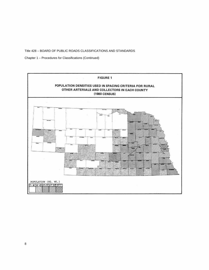
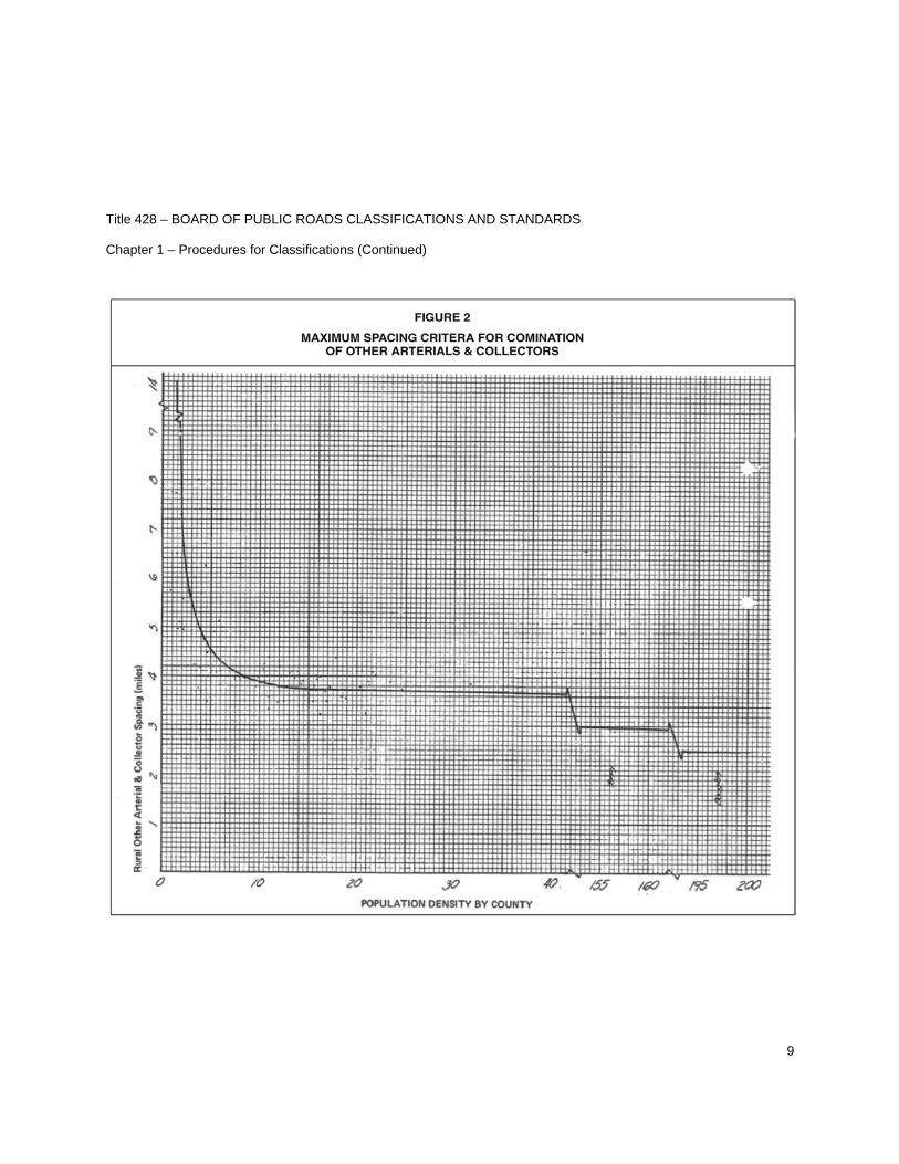
5. Spacing – See Figures 1 and 2.
6. Mileage limitation – See Collector.
001.05 COLLECTOR – shall consist of a group of highways which pick up traffic from many local or land-service roads and carry it to community centers or to the arterial systems. They are the main school bus routes, mail routes, and farm-to-market routes.
SPECIFIC CRITERIA
1. All community centers and agricultural activity centers not on higher systems should be connected with each other and connected with the higher systems by a collector road.
2. Clustered residents who are at considerable distances from the previous selected systems should be served.
3. Spacing should be at intervals, consistent with population density, to collect traffic from local roads and bring all developed areas within a reasonable distance of a collector road. The spacing recommended is shown in Figure 2.
4. The total number of miles in the Other Arterial and Collector Systems shall be limited as shown in Table 1.
5. The location of collector routes should be coordinated at county lines to form an integrated system.
001.06 LOCAL – shall consist of all remaining rural roads, except remote residential and minimum maintenance roads.
SPECIFIC CRITERIA
1. Shall serve, in conjunction with remote residential roads, all occupied residences with connection to another local or higher system classification.
2. Shall serve, in conjunction with remote residential roads, all cemeteries, parks, wildlife management areas or other rural areas with a connection to another local or higher system classification.
3. Shall serve, in conjunction with remote residential roads, all school bus and mail routes not served by a higher system.
4. Shall be so spaced, in conjunction with remote residential roads, as to avoid considerable extra travel or normal travel over minimum maintenance roads.
Title 428 – BOARD OF PUBLIC ROADS CLASSIFICATIONS AND STANDARDS Chapter 1 – Procedures for Classifications (Continued)
5
001.07 REMOTE RESIDENTIAL
GENERAL CRITERIA
General Criteria from Chapter 39, Section 39-2103(9) Nebraska Revised Statutes - shall consist of roads or segments of roads in remote areas of counties with (a) a population density of no more than five people per square mile or (b) an area of at least one thousand square miles, and which roads or segments of roads serve as primary access to no more than seven residences. For the purposes of this subdivision, residence means a structure which serves as a primary residence for more than six months of a calendar year. Population shall be determined using data from the most recent federal decennial census.
SPECIFIC CRITERIA
1. Remote Residential roads shall serve qualified properties having occupied residences with a connection to another remote residential, local or higher system classification. In conjunction with such service, they may also serve as school bus and mail routes and serve farms, ranches, cemeteries, parks, wildlife management areas or other rural areas. For the purpose of this section “qualified” shall pertain to the county population density or area size set forth above.
2. Remote Residential roads shall be sufficient to provide access to properties having remote residences, farms, and ranches by passenger and commercial vehicles. One-lane traffic is allowed where sight distance is adequate to warn motorists of oncoming traffic.
RESTRICTIONS
1. County Board Public Hearing – A County Board Public Hearing is required prior to requesting the department to classify a new road segment or an extension to an existing road segment or to reclassify an existing road segment as a Remote Residential road. For county line roads, each adjoining county shall meet the general criteria of Chapter 39, Section 39-2103(9) Nebraska Revised Statutes and each County Board shall hold a public hearing on the matter prior to requesting the department to classify.
2. Relaxation of Standards – In addition to the County Board Public Hearing, a Relaxation of Standards granted by the Board is required for construction of a new road segment or an extension to an existing road segment, or when a county wants an existing non-surfaced road segment or an existing one-lane road segment with inadequate sight distance reclassified to remote residential. See 428 NAC 2, Section 004.
3. The Functional Classification will only be assigned by the department when requested by official action of a County Board.
Title 428 – BOARD OF PUBLIC ROADS CLASSIFICATIONS AND STANDARDS Chapter 1 – Procedures for Classifications (Continued)
6
001.08 MINIMUM MAINTENANCE – shall consist of roads used occasionally by a limited number of people as alternative access roads for areas served primarily by local, collector, or arterial roads or roads which are the principal access roads to agricultural lands for farm machinery and farm trucks, and which are not primarily used by passenger or commercial vehicles and are not intended for school bus or mail routes.
SPECIFIC CRITERIA
1. Shall provide for travel during normal weather, shall not require snow removal or roadway mowing, except to prevent hazard.
2. Minimum maintenance roads may be earth or turf covered.
3. County line coordination – minimum maintenance roads should not stub at a county line.
4. May not be the only access to an occupied dwelling – a minimum maintenance road shall be reclassified to remote residential, local or a higher functional classification whenever an existing dwelling or newly constructed dwelling becomes occupied.
Title 428 – BOARD OF PUBLIC ROADS CLASSIFICATIONS AND STANDARDS Chapter 1 – Procedures for Classifications (Continued)
7
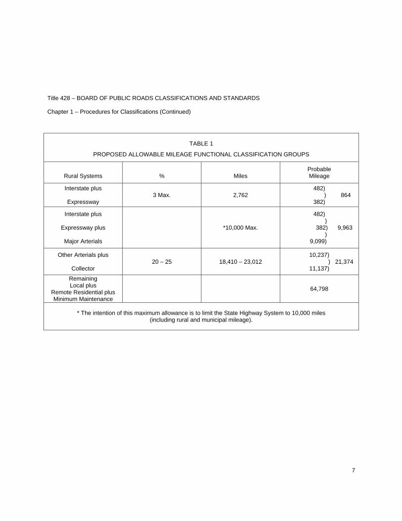
TABLE 1
PROPOSED ALLOWABLE MILEAGE FUNCTIONAL CLASSIFICATION GROUPS
Rural Systems
%
Miles
Probable Mileage
Interstate plus
Expressway 3 Max. 2,762
482) ) 864
382)
Interstate plus
Expressway plus
Major Arterials
*10,000 Max.
482) )
382) 9,963 )
9,099)
Other Arterials plus
Collector 20 – 25 18,410 – 23,012
10,237) ) 21,374
11,137)
Remaining Local plus
Remote Residential plus Minimum Maintenance
64,798
* The intention of this maximum allowance is to limit the State Highway System to 10,000 miles
(including rural and municipal mileage).
Title 428 – BOARD OF PUBLIC ROADS CLASSIFICATIONS AND STANDARDS Chapter 1 – Procedures for Classifications (Continued)
8
Title 428 – BOARD OF PUBLIC ROADS CLASSIFICATIONS AND STANDARDS Chapter 1 – Procedures for Classifications (Continued)
9
Title 428 – BOARD OF PUBLIC ROADS CLASSIFICATIONS AND STANDARDS Chapter 1 – Procedures for Classifications (Continued)
10
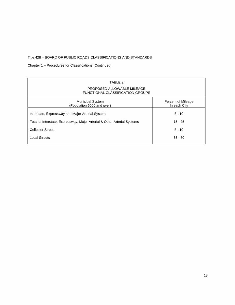
002 SPECIFIC CRITERIA FOR THE FUNCTIONAL CLASSIFICATION OF MUNICIPAL STREETS. Municipal streets shall consist of all public streets within the limits of any incorporated municipality. It is recommended the municipalities be divided into three population groups to facilitate the comparison process which inevitably must take place between cities and villages of similar sizes. These streets shall be divided into six functional classifications groups. Each incorporated municipality with a population over five thousand shall approximate the guideline mileage percentages established in Table 2.
002.01 POPULATION GROUP I – OVER FIFTY THOUSAND (URBANIZED AREAS)
002.01A INTERSTATE – shall consist of the federally-designated National System of Interstate and Defense Highways.
002.01B EXPRESSWAY – which shall consist of two categories: Extension of rural expressways within some urban areas and some additional routes which serve very high volumes of local traffic.
SPECIFIC CRITERIA
1. Provide connecting link for rural expressways which intercept the incorporated municipalities. 2. Provide routes for major traffic generators within the city. 3. Expressway system one in which ultimately should be developed to multi-lane divided
highway standards. 4. Provide an integrated network without stub connections.
002.01C MAJOR ARTERIAL – shall consist of extensions of rural major arterials which provide continuous service through municipalities for long distance rural travel. They are the arterial streets used to transport products into and out of municipalities.
SPECIFIC CRITERIA
1. Connecting link for rural major arterials.
2. Serve the major activity centers of the urban area not served by the higher systems.
3. Serve the highest traffic volume corridors not served by the higher systems.
4. Service to abutting land should not be a primary functional responsibility of this class of street. 5. Serve the longest trip desires not served by the higher systems. 6. Should (in conjunction with the higher systems) carry a high proportion of the total urban area
travel on a minimum of mileage.
Title 428 – BOARD OF PUBLIC ROADS CLASSIFICATIONS AND STANDARDS Chapter 1 – Procedures for Classifications (Continued)
11
7. System should be integrated both internally and between major rural connections. 8. Spacing (in conjunction with the higher systems) may vary from less than one mile in Central
Business District to five miles in urban fringe.
002.01D OTHER ARTERIAL – which shall consist of two categories: municipal extensions of rural other arterials, and arterial movements peculiar to a municipality’s own complex, that is streets which interconnect major areas of activity within a municipality, such as shopping centers, the Central Business District, manufacturing centers, and industrial parks.
SPECIFIC CRITERIA
1. Provide connecting link for rural other arterials. 2. Intra-community connections of areas of activities in municipalities not connected by a higher
order system, such as shopping centers, central business district, manufacturing and industrial areas.
3. Interconnect with and augment the urban major arterial system. This need not form an
integrated system in all cases. 4. Spacing may vary from one-eighth to one-half mile in the Central Business District to two to
three miles in the suburban fringe, but should normally be not more than one mile in fully developed areas.
002.01E COLLECTOR – shall consist of a group of streets which collect traffic from residential streets and move it to smaller commercial centers or to higher arterial systems.
SPECIFIC CRITERIA
1. Collect traffic from local streets in neighborhood and channels it to the arterial system.
2. Provide land access service within residential neighborhoods, commercial areas and
industrial areas.
3. Spacing should be at intervals consistent with population density.
002.01F LOCAL – shall consist of the balance of streets in each municipality, principally residential access service streets and local business streets. They are characterized by very short trip lengths, almost exclusively limited to vehicles desiring to go to or from adjacent property.
Title 428 – BOARD OF PUBLIC ROADS CLASSIFICATIONS AND STANDARDS Chapter 1 – Procedures for Classifications (Continued)
12
002.02 POPULATION GROUP II – FIVE THOUSAND TO FORTY-NINE THOUSAND (SMALL URBAN AREAS)
002.02A INTERSTATE – None
002.02B EXPRESSWAY – Due to present design plans, most cities in this population group will be by-passed with expressways or arterials outside the corporate limits.
002.02C MAJOR ARTERIAL – OTHER ARTERIAL – COLLECTOR – LOCAL – Same specific criteria as for those in Population Group I.
002.03 POPULATION GROUP III – ONE TO FIVE THOUSAND (VILLAGES AND SECOND CLASS CITIES). In the National Highway Functional Classification Study the mileage in cities of less than five thousand population was classified as rural. The specific criteria for small urban areas is generally applicable to these smaller cities and villages. The basic difference is that, by nature of their size, small municipalities will not generate internal travel warranting a network of arterial service.
002.03A INTERSTATE – None
002.03B EXPRESSWAY – None
002.03C MAJOR ARTERIAL – Extension of all major rural arterials into and through these municipalities which are on the State Highway System including stubs and spurs to towns above one hundred population.
002.03D OTHER ARTERIAL – Municipal extension of high volume rural collectors on county system.
002.03E COLLECTOR – Municipal extension of low volume collectors on county system.
002.03F LOCAL – All streets not on one of the higher systems.
Title 428 – BOARD OF PUBLIC ROADS CLASSIFICATIONS AND STANDARDS Chapter 1 – Procedures for Classifications (Continued)
13
TABLE 2
PROPOSED ALLOWABLE MILEAGE FUNCTIONAL CLASSIFICATION GROUPS
Municipal System (Population 5000 and over)
Percent of Mileage In each City
Interstate, Expressway and Major Arterial System Total of Interstate, Expressway, Major Arterial & Other Arterial Systems Collector Streets Local Streets
5 - 10
15 - 25
5 - 10
65 - 80
Title 428 – BOARD OF PUBLIC ROADS CLASSIFICATIONS AND STANDARDS Chapter 1 – Procedures for Classifications (Continued)
14
003 SPECIFIC CRITERIA FOR THE FUNCTIONAL CLASSIFICATION OF SCENIC - RECREATION ROADS.
003.01 Scenic-Recreation, which shall consist of highways or roads located within or which provide access to or through state parks, recreation or wilderness areas, other areas of geographical, historical, geological, recreational, biological, or archaeological significance, or areas of scenic beauty; and are defined as follows:
1. State Parks as defined by 81-815.22 Neb. Rev. Stat. shall mean parks of substantial area with primary value of significant statewide scenic, scientific or historical interest, having a complete development potential and, where possible, a representative portion which can be retained in a natural or relatively undisturbed state.
2. State Recreation or Wilderness Areas as defined by 81-815.22 Neb. Rev. Stat. shall mean areas with a primary value for day use, but with secondary overnight-use facilities or potential, which have reasonable expansion capability and are located in accordance with sound park management principles.
3. Geographic Areas shall consist of a unique or unusual area which has particular interest and is not usually present in extensive numbers in the immediate area.
4. Historical Areas shall include areas which have been determined by the State Historical Society to be historic sites or have been registered or nominated to be included in the National Register of Historic Places.
5. Geological Areas shall consist of unique or unusual areas which have particular interest in the interpretation of geologic information and are the best areas of information in that particular region.
6. Recreational Areas as defined in 81-815.22 Neb. Rev. Stat. State wayside areas shall be areas appropriate in size and located at strategic intervals adjacent to main travelled highways to provide safe rest and picnic stops for travelers, which sites shall be selected for scenic or historical interest, when possible. Equipped with safe approach and departure lanes, and be developed in a manner and with such facilities as are appropriate to their purpose and State Special Use areas shall be those areas which are primarily of public hunting, fishing, or other wildlife values, and which cannot logically be classified in one of the categories listed in sub-divisions 2, 3, 4 or 5 of this section, when so designated by the Nebraska Game and Parks Commission to be maintained from fish and game funds.
7. Biological Significance areas are defined as only those areas where a unique or unusual life form or process exists and only that area that is most unusual in the given region of the State.
8. Archaeological Significant areas are areas for which the Nebraska State Historical Society has declared an archaeological significance. A joint agreement exists between the Society and the Department of Roads concerning these areas if a road project proposes to infringe on them.
Title 428 – BOARD OF PUBLIC ROADS CLASSIFICATIONS AND STANDARDS Chapter 1 – Procedures for Classifications (Continued)
15
9. Scenic. No precise definition of scenic is possible as stated in the Scenic Highways Narrative dated March 12, 1974, by the Nebraska Game and Parks Commission. “Scenery, as with other forms of beauty, lies in the eyes of the beholder, and an element of subjectivity is bound to be a part of any attempt to develop and apply objective criteria and guideline.”
003.02 Jurisdictional responsibility for all scenic-recreation roads and highways shall remain with the governmental subdivision which had jurisdictional responsibility for such road or highway prior to its change in classification to scenic-recreation.
003.03 Specific Criteria for Scenic-Recreation roads shall be divided into two classes.
1. Highways and roads providing access to or to and through scenic-recreation area.
2. Highways and roads located within scenic-recreation area.
003.03A Specific Criteria – Scenic-Recreation roads providing access to or to and through Scenic-Recreation Area:
003.03A1 Highways functionally classified as Interstate shall not be considered for a scenic-recreation classification.
003.03A2 Highways functionally classified as Expressway shall not be considered for a scenic-recreation classification.
003.03A3 SPECIFIC CRITERIA – SCENIC - RECREATION - MAJOR ARTERIAL
1. Scenic-Recreation-Major Arterial shall consist of state highways which provide access to or to and through scenic-recreation areas and which qualify for a Major Arterial Functional Classification.
2. Limits of a Scenic-Recreation Highway to be classified Scenic-Recreation-Major Arterial shall be determined from logical points of Scenic-Recreation interest. Termini may be from a road with any functional classification.
3. Scenic-Recreation-Major Arterial highways to Scenic-Recreation areas shall meet or exceed applicable minimum standards unless a request for Relaxation of Standards has been granted by the Board of Public Roads Classifications and Standards.
4. Effort shall be made to preserve the natural environment to the extent possible without compromising the safety of those using the facility, at the speed limits that apply.
Title 428 – BOARD OF PUBLIC ROADS CLASSIFICATIONS AND STANDARDS Chapter 1 – Procedures for Classifications (Continued)
16
003.03A4 SPECIFIC CRITERIA – SCENIC - RECREATION - OTHER ARTERIAL
1. Scenic-Recreation-Other Arterial shall consist of roads which provide access to or to and through scenic-recreation areas and which qualify for an Other Arterial Functional Classification.
2. Limits of a Scenic-Recreation Road to be classified Scenic-Recreation-Other Arterial shall be determined from logical points of Scenic-Recreation interest. Termini may be from a road with any functional classification.
3. Scenic-Recreation-Other Arterial roads to Scenic-Recreation areas shall meet or exceed applicable minimum standards unless a request for Relaxation of Standards has been granted by the Board of Public Roads Classifications and Standards.
4. Effort shall be made to preserve the natural environment to the extent possible without compromising the safety of those using the facility at the speed limits that apply.
003.03A5 SPECIFIC CRITERIA – SCENIC - RECREATION - COLLECTOR
1. Scenic-Recreation-Collector shall consist of roads which provide access to or to and through Scenic-Recreation areas and which qualify for a Collector Functional Classification.
2. Limits of a Scenic-Recreation Road to be classified Scenic-Recreation-Collector shall be determined from logical points of Scenic-Recreation interest. Termini may be from a road with any functional classification.
3. Scenic-Recreation-Collector roads to Scenic-Recreation areas shall meet or exceed applicable minimum standards unless a request for Relaxation of Standards has been granted by the Board of Public Roads Classifications and Standards.
4. Effort shall be made to preserve the natural environment to the extent possible without compromising the safety of those using the facility at the speed limits that apply.
Title 428 – BOARD OF PUBLIC ROADS CLASSIFICATIONS AND STANDARDS Chapter 1 – Procedures for Classifications (Continued)
17
003.03A6 SPECIFIC CRITERIA – SCENIC - RECREATION - LOCAL
1. Scenic-Recreation-Local shall consist of roads which provide access to or to and through Scenic-Recreation areas and which qualify for a Local Functional Classification.
2. Limits of a Scenic-Recreation Road to be classified Scenic-Recreation-Local shall be determined from logical points of Scenic-Recreation interest. Termini may be from a road with any functional classification.
3. Scenic-Recreation-Local roads to Scenic-Recreation areas shall meet or exceed applicable minimum standards unless a request for Relaxation of Standards has been granted by the Board of Public Roads Classifications and Standards.
4. Effort shall be made to preserve the natural environment to the extent possible without compromising the safety of those using the facility at the speed limits that apply.
003.03A7 Highways functionally classified as Remote Residential shall not be considered for a Scenic-Recreation classification.
003.03A8 Highways functionally classified as Minimum Maintenance shall not be considered for a Scenic-Recreation classification.
003.03B SPECIFIC CRITERIA – SCENIC - RECREATION - INTERNAL ROADS
1. Those roads located within the Scenic-Recreation area which are not through routes. Scenic-Recreation Internal Roads serve as routes within Scenic-Recreation areas.
2. Jurisdictional responsibility is in accordance with the approved Functional Classification.
3. The location of Scenic-Recreation-Internal roads shall be coordinated with other roads in the area so that both through and scenic-recreational travel is served, unless the route terminates in an area as previously described and is not a through route.
Title 428 – BOARD OF PUBLIC ROADS CLASSIFICATIONS AND STANDARDS Chapter 1 – Procedures for Classifications (Continued)
18
004 FUNCTIONAL CLASSIFICATION ASSIGNMENT APPEAL TO THE BOARD OF PUBLIC ROADS CLASSIFICATIONS AND STANDARDS
004.01 Any County or Municipality may, based on changing traffic patterns or volume, request the Department of Roads to reclassify any segment of highway, road or street. The Department shall review such request and either grant or deny the reclassification in whole or in part. Any County or Municipality dissatisfied with the action taken by the Department under this section, may appeal to the Board of Public Roads Classifications and Standards.
004.02 An appeal of assigned functional classification by any County or Municipality shall be submitted to the Board of Public Roads Classifications and Standards in writing. Appeal documentation shall include:
1. One copy of the Resolution, by the County Board or City Council, appealing the assigned functional classification and specifying the functional classification requested.
2. One copy of a map showing the location of the road or street. Beginning and ending points shall be identified.
3. Evidence that the Department of Roads denied a request for reclassification.
4. Traffic count data to include location of traffic count station(s) and date(s).
004.03 Upon the talking of such an appeal, the Board shall review all information pertaining to the assignment and hold a hearing thereon if deemed advisable. The determination, on whether or not a Public Hearing shall be held, shall be by Roll Call Vote. The Board shall set the time and place of Public Hearing.
004.04 When a functional classification appeal Public Hearing is scheduled by the Board, the Secretary for the Board shall:
1. Notify in writing the County(s) and/or Municipality(s) of the time and place for Public Hearing at least ten days prior to the Hearing.
2. Notify in writing the Director-State Engineer, Department of Roads the time and place for Public Hearing at least ten days prior to the Hearing.
3. Cause to be published a legal notice of Public hearing at least ten days prior thereto in a designated legal newspaper in the County(s) and/or Municipality(s) at least one time stating the time and place and purpose of the Public Hearing. Such legal notice shall also be published in a legal newspaper with statewide circulation.
4. Notify in writing the members of the Board and place the Public Hearing on the Agenda.
Title 428 – BOARD OF PUBLIC ROADS CLASSIFICATIONS AND STANDARDS Chapter 1 – Procedures for Classifications (Continued)
19
5. Prepare the Public Hearing format which will be divided into three parts in addition to the opening and closing statements.
PART ONE. The County(s) and/or Municipality(s) shall present their appeal.
PART TWO. The Department of Roads shall present information concerning the functional classification as assigned.
PART THREE. The Board shall conduct a question and answer period if deemed advisable.
004.05 FUNCTIONAL CLASSIFICATION APPEAL TRANSCRIPTS. All Functional Classification Appeals shall be recorded and a written transcript prepared under the direction of the Secretary for the Board.
Statements or exhibits submitted to the Board within ten days following the Public Hearing will become an official part of the Public Hearing transcript.
One copy of the Public Hearing transcript shall be furnished to each Board member. The Board shall examine the transcript for correctness. The accepted Public Hearing transcript shall then be available for public inspection and copying at the Department of Roads’ Headquarters, South Junction U.S. 77 and N-2, Lincoln, Nebraska.
004.06. Within ninety days of the date of the hearing, the Board will meet, consider the request, and by one vote, grant or deny the appeal either in whole or in part. An affirmative vote of at least six members will be necessary to grant an appeal. A permanent record will be maintained of the Board’s decision. A copy will be distributed to the requesting County(s) or Municipality(s) to the Department of Roads, and to any interested party requesting a record of the proceeding.
The Boards’ decision on the assigned classification shall be subject to the provisions of Chapter 84, Article 9 Neb. Rev. Stat.

20
1
Title 428 - BOARD OF PUBLIC ROADS CLASSIFICATIONS AND STANDARDS
Chapter 2 - Procedures for Standards
Contents.......................................................................................................................................................... Section
Table of Contents............................................................................................................................................ —
Minimum Design Standards............................................................................................................................ 001
MINIMUM DESIGN STANDARDS -- PART ONESTATE HIGHWAY SYSTEM
Minimum Design Standards - Rural (Amended March 21, 2008)New and Reconstructed Rural State Highways .................................................................................. 001.01Bridges on Rural State Highways ........................................................................................................ 001.02Resurfacing, Restoration and Rehabilitation (3R) Projects onRural State Highways ........................................................................................................................ 001.03Scenic - Recreation - Rural State Highways ...................................................................................... 001.04
Typical Cross Section of Improvement for New andReconstructed State Highways (Amended March 21, 2008)Interstate Interchange Ramp .............................................................................................................. 001.05
Typical Cross Sections of Improvements for New andReconstructed Rural State Highways (Amended March 21, 2008)Design Number DR1 (Crowned) ......................................................................................................... 001.06Design Number DR1 (Tangent) .......................................................................................................... 001.06ADesign Number DR2 (Crowned) ......................................................................................................... 001.07Design Number DR2 (Tangent) .......................................................................................................... 001.07ADesign Number DR3 ........................................................................................................................... 001.08Design Number DR4 ........................................................................................................................... 001.09Design Number DR5 ........................................................................................................................... 001.10Design Number DR6 ........................................................................................................................... 001.11
Minimum Design Standards - Municipal (Amended March 21, 2008)New and Reconstructed Municipal State Highways ........................................................................... 001.12Bridges on Municipal State Highways ................................................................................................ 001.13Resurfacing, Restoration and Rehabilitation (3R) Projects onMunicipal State Highways .................................................................................................................. 001.14
Last Issue Date: March 21, 2008
NEBRASKA ADMINISTRATIVE CODE
2
Contents.......................................................................................................................................................... Section
MINIMUM DESIGN STANDARDS -- PART TWOLOCAL ROADS AND STREETS
ANDEXPLANATORY STATEMENT
FOR FIXED OBSTACLE CLEARANCE FOOTNOTESTO MINIMUM DESIGN STANDARDS (COUNTY ROADS AND MUNICIPAL STREETS)
ADOPTED 9/20/02
Minimum Design Standards Municipal Streets (Amended March 21, 2008) ...................................................................................... 001.15Rural Roads (Amended July 17, 2009).................................................................................................. 001.16Scenic - Recreation - Rural Roads (Amended March 21, 2008) ........................................................... 001.17
Typical Cross Sections for Rural Roads (Amended October 26, 2001)Design Number ROA1 ........................................................................................................................ 001.18Design Number ROA2, RC1, RL1 ...................................................................................................... 001.19Design Number ROA3, RC2, RL2 ...................................................................................................... 001.20Design Number ROA4, RC3 ............................................................................................................... 001.21Design Number RL3 ........................................................................................................................... 001.22
Minimum Construction Standards (Adopted September 20, 1974) ....................................................... 002
Minimum Maintenance Standards (Adopted September 16, 1983) ....................................................... 003
Relaxation of Standards (Adopted July 19, 1985) ................................................................................. 004
Relaxation of Standards for Scenic - Recreation Roads (Adopted January 16, 1981) ......................... 005
Minimum Standards for Remote Residential Roads (Adopted July 17, 2009) ........................................ 006
Maintenance Standards for Minimum Maintenance Roads (Adopted July 19, 1985) ........................... 007
Standard Compliance Inspection Procedures (Adopted March 15, 1974) ............................................ 008
3
Title 428 - BOARD OF PUBLIC ROADS CLASSIFICATIONS AND STANDARDSChapter 2 - Procedures for Standards
001 MINIMUM DESIGN STANDARDS.
Copies of the most current editions of the following documents referred to in the Standards are on file in the NDORCentral Administration Complex, 1500 Highway 2, Lincoln, Nebraska:
AASHTO “A Policy on Geometric Design of Highways and Streets”AASHTO “A Policy on Design Standards — Interstate System”AASHTO “Guidelines for Geometric Design of Very Low-Volume Local Roads (ADT ≤ 400)”NDOR “Nebraska National Highway Functional Classification” MapNDOR “Nebraska State Highway Functional Classification” MapNDOR “State Functional Classification” Maps (Counties and Municipalities)NDOR “Nebraska Interstate and Priority Commercial Systems” Map
The following abbreviations and symbols are used in the Standards:
3R Resurfacing, Restoration and Rehabilitation' foot or feetAASHTO American Association of State Highway and Transportation OfficialsADT Average Daily TrafficBoard Board of Public Roads Classifications and StandardscL centerlineDiv. dividedft foot or feetHL93 AASHTO Load and Resistance Factor Design (LRFD) Bridge Design SpecificationLt. leftmph miles per hourN/A not applicableNDOR Nebraska Department of RoadsRSAP Roadside Safety Analysis ProgramRt. right% percent
The following definitions apply only to the State Highway System:
Soft conversion: Changing to the exact calculated metric number.Reconstructed bridge work includes replacement of the entire superstructure.

4

Part OneState Highway System
Title 428 — BOARD OF PUBLIC ROADS CLASSIFICATIONS AND STANDARDS
Chapter 2 — Procedures for Standards (Continued)MINIMUM DESIGN STANDARDS - PART ONE
STATE HIGHWAY SYSTEM
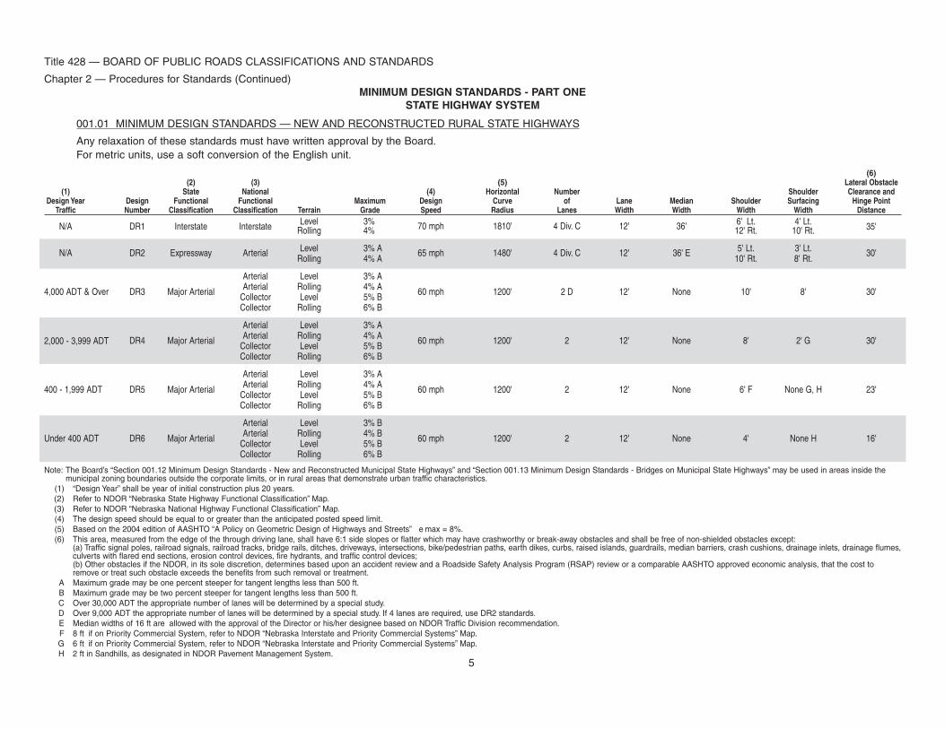
001.01 MINIMUM DESIGN STANDARDS — NEW AND RECONSTRUCTED RURAL STATE HIGHWAYS
Any relaxation of these standards must have written approval by the Board.For metric units, use a soft conversion of the English unit.
(6)(2) (3) (5) Lateral Obstacle
(1) State National (4) Horizontal Number Shoulder Clearance andDesign Year Design Functional Functional Maximum Design Curve of Lane Median Shoulder Surfacing Hinge Point
Traffic Number Classification Classification Terrain Grade Speed Radius Lanes Width Width Width Width Distance
N/A DR1 Interstate Interstate Level 3% 70 mph 1810' 4 Div. C 12' 36' 6' Lt. 4' Lt. 35'Rolling 4% 12' Rt. 10' Rt.
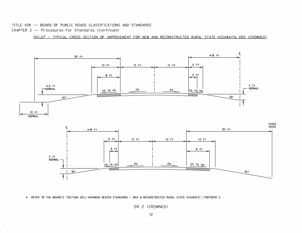
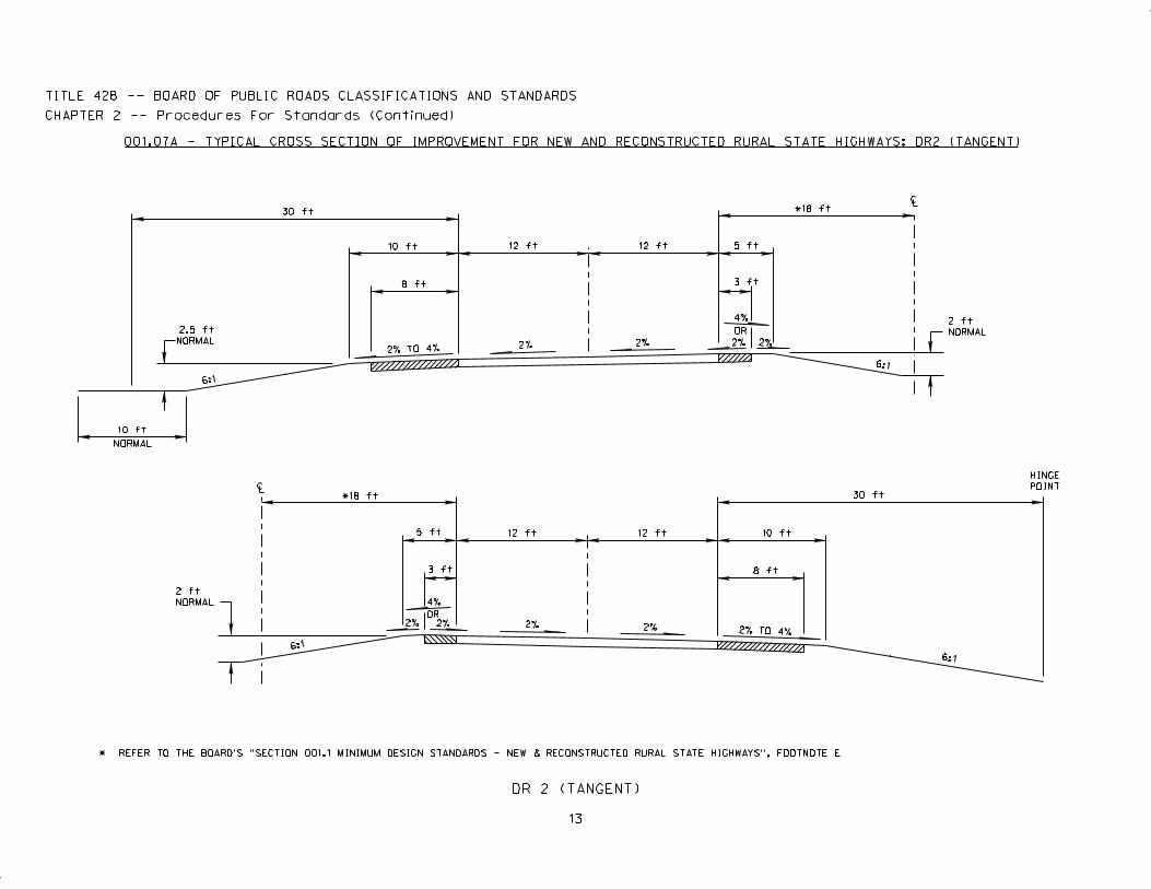
N/A DR2 Expressway Arterial Level 3% A 65 mph 1480' 4 Div. C 12' 36' E 5' Lt. 3' Lt. 30'Rolling 4% A 10' Rt. 8' Rt.
Arterial Level 3% A
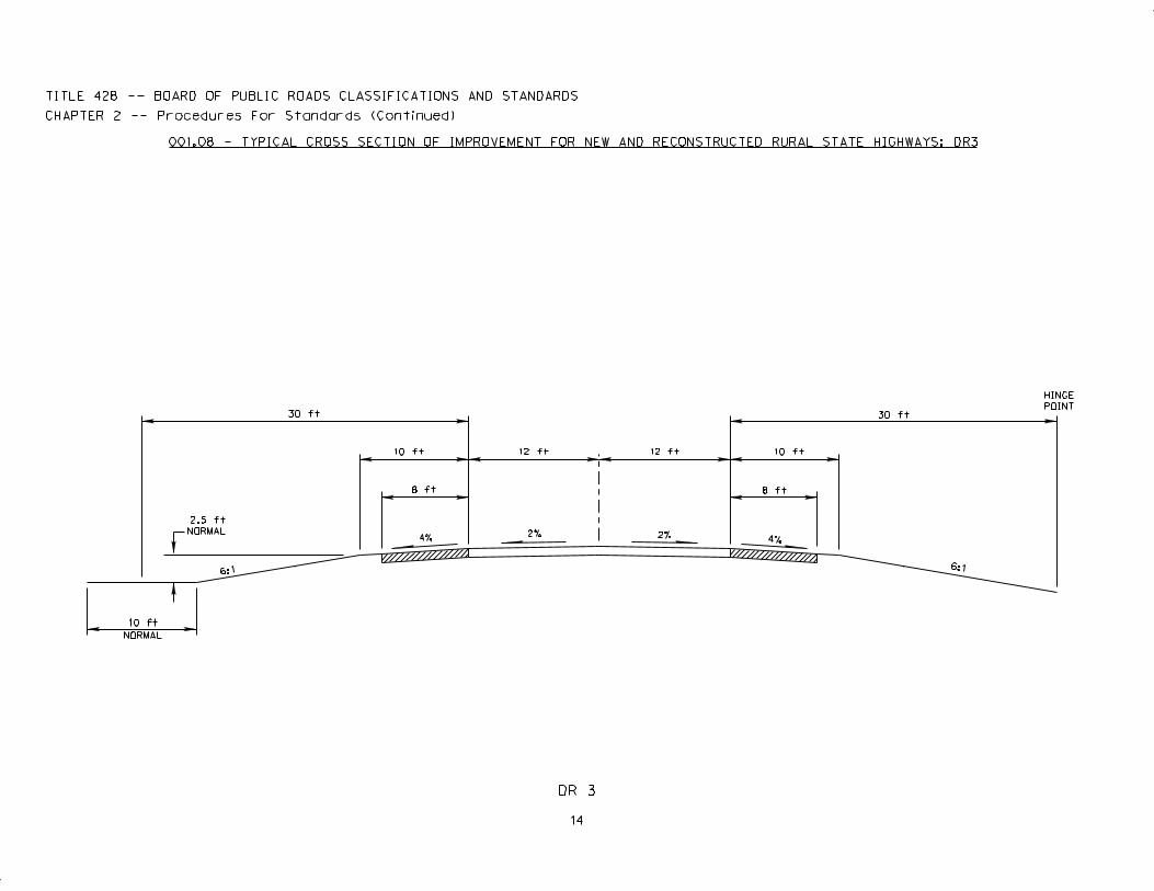
4,000 ADT & Over DR3 Major Arterial Arterial Rolling 4% A 60 mph 1200' 2 D 12' None 10' 8' 30'Collector Level 5% BCollector Rolling 6% B
Arterial Level 3% A
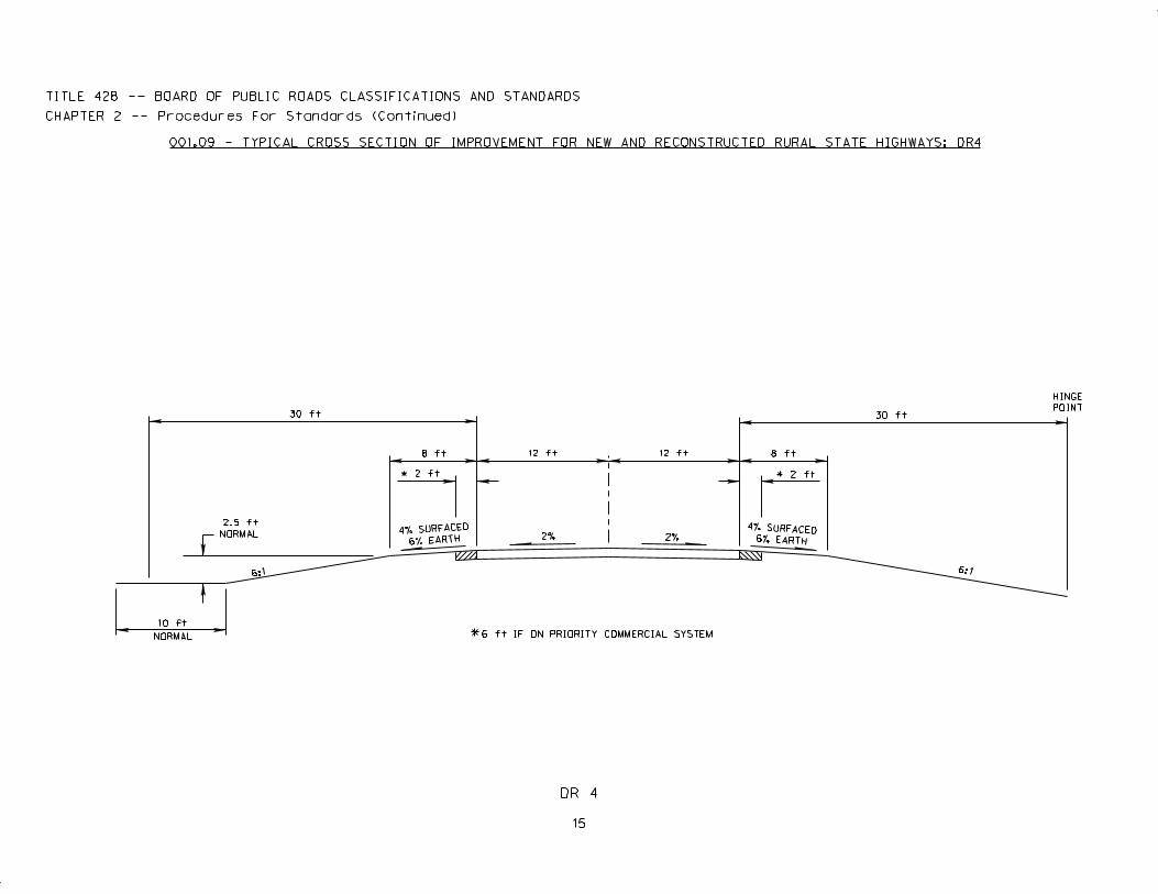
DR4 Major Arterial Arterial Rolling 4% A 60 mph 1200' 2 12' None 8' 2' G 30'2,000 - 3,999 ADT Collector Level 5% BCollector Rolling 6% B
Arterial Level 3% A
400 - 1,999 ADT DR5 Major Arterial Arterial Rolling 4% A 60 mph 1200' 2 12' None 6' F None G, H 23'Collector Level 5% BCollector Rolling 6% B
Arterial Level 3% B
Under 400 ADT DR6 Major Arterial Arterial Rolling 4% B 60 mph 1200' 2 12' None 4' None H 16'Collector Level 5% BCollector Rolling 6% B
Note: The Board’s “Section 001.12 Minimum Design Standards - New and Reconstructed Municipal State Highways” and “Section 001.13 Minimum Design Standards - Bridges on Municipal State Highways” may be used in areas inside themunicipal zoning boundaries outside the corporate limits, or in rural areas that demonstrate urban traffic characteristics.
(1) “Design Year” shall be year of initial construction plus 20 years.(2) Refer to NDOR “Nebraska State Highway Functional Classification” Map.(3) Refer to NDOR “Nebraska National Highway Functional Classification” Map.(4) The design speed should be equal to or greater than the anticipated posted speed limit.(5) Based on the 2004 edition of AASHTO “A Policy on Geometric Design of Highways and Streets” e max = 8%.(6) This area, measured from the edge of the through driving lane, shall have 6:1 side slopes or flatter which may have crashworthy or break-away obstacles and shall be free of non-shielded obstacles except:
(a) Traffic signal poles, railroad signals, railroad tracks, bridge rails, ditches, driveways, intersections, bike/pedestrian paths, earth dikes, curbs, raised islands, guardrails, median barriers, crash cushions, drainage inlets, drainage flumes,culverts with flared end sections, erosion control devices, fire hydrants, and traffic control devices;(b) Other obstacles if the NDOR, in its sole discretion, determines based upon an accident review and a Roadside Safety Analysis Program (RSAP) review or a comparable AASHTO approved economic analysis, that the cost toremove or treat such obstacle exceeds the benefits from such removal or treatment.
A Maximum grade may be one percent steeper for tangent lengths less than 500 ft.B Maximum grade may be two percent steeper for tangent lengths less than 500 ft.C Over 30,000 ADT the appropriate number of lanes will be determined by a special study.D Over 9,000 ADT the appropriate number of lanes will be determined by a special study. If 4 lanes are required, use DR2 standards.E Median widths of 16 ft are allowed with the approval of the Director or his/her designee based on NDOR Traffic Division recommendation.F 8 ft if on Priority Commercial System, refer to NDOR “Nebraska Interstate and Priority Commercial Systems” Map.G 6 ft if on Priority Commercial System, refer to NDOR “Nebraska Interstate and Priority Commercial Systems” Map.H 2 ft in Sandhills, as designated in NDOR Pavement Management System.
5
Title 428 — BOARD OF PUBLIC ROADS CLASSIFICATIONS AND STANDARDS
Chapter 2 — Procedures for Standards (Continued)
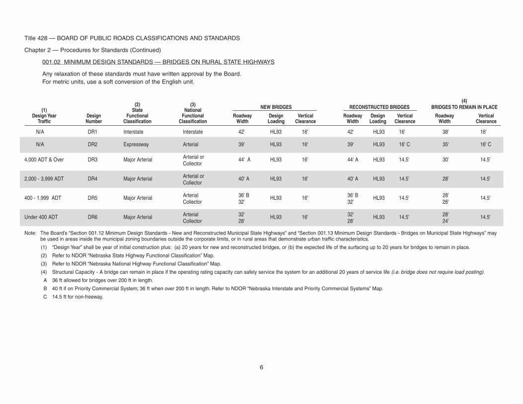
001.02 MINIMUM DESIGN STANDARDS — BRIDGES ON RURAL STATE HIGHWAYS
Any relaxation of these standards must have written approval by the Board.For metric units, use a soft conversion of the English unit.
(4)(2) (3) NEW BRIDGES RECONSTRUCTED BRIDGES BRIDGES TO REMAIN IN PLACE(1) State National
Design Year Design Functional Functional Roadway Design Vertical Roadway Design Vertical Roadway VerticalTraffic Number Classification Classification Width Loading Clearance Width Loading Clearance Width Clearance
N/A DR1 Interstate Interstate 42' HL93 16' 42' HL93 16' 38' 16'
N/A DR2 Expressway Arterial 39' HL93 16' 39' HL93 16' C 35' 16' C
4,000 ADT & Over DR3 Major Arterial Arterial or 44' A HL93 16' 44' A HL93 14.5' 30' 14.5'Collector
2,000 - 3,999 ADT DR4 Major Arterial Arterial or 40' A HL93 16' 40' A HL93 14.5' 28' 14.5'Collector
400 - 1,999 ADT DR5 Major Arterial Arterial 36' B HL93 16' 36' B HL93 14.5' 28' 14.5'Collector 32' 32' 26'
Under 400 ADT DR6 Major Arterial Arterial 32' HL93 16' 32' HL93 14.5' 28' 14.5'Collector 28' 28' 24'
Note: The Board’s “Section 001.12 Minimum Design Standards - New and Reconstructed Municipal State Highways” and “Section 001.13 Minimum Design Standards - Bridges on Municipal State Highways” maybe used in areas inside the municipal zoning boundaries outside the corporate limits, or in rural areas that demonstrate urban traffic characteristics.
(1) “Design Year” shall be year of initial construction plus: (a) 20 years for new and reconstructed bridges, or (b) the expected life of the surfacing up to 20 years for bridges to remain in place.
(2) Refer to NDOR “Nebraska State Highway Functional Classification” Map.
(3) Refer to NDOR “Nebraska National Highway Functional Classification” Map.
(4) Structural Capacity - A bridge can remain in place if the operating rating capacity can safely service the system for an additional 20 years of service life (i.e. bridge does not require load posting).
A 36 ft allowed for bridges over 200 ft in length.
B 40 ft if on Priority Commercial System; 36 ft when over 200 ft in length. Refer to NDOR “Nebraska Interstate and Priority Commercial Systems” Map.
C 14.5 ft for non-freeway.
6
Title 428 — BOARD OF PUBLIC ROADS CLASSIFICATIONS AND STANDARDS
Chapter 2 — Procedures for Standards (Continued)
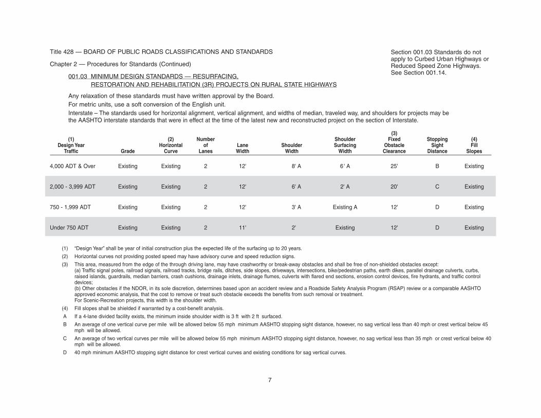
001.03 MINIMUM DESIGN STANDARDS — RESURFACING,RESTORATION AND REHABILITATION (3R) PROJECTS ON RURAL STATE HIGHWAYS
Any relaxation of these standards must have written approval by the Board.For metric units, use a soft conversion of the English unit.Interstate – The standards used for horizontal alignment, vertical alignment, and widths of median, traveled way, and shoulders for projects may bethe AASHTO interstate standards that were in effect at the time of the latest new and reconstructed project on the section of Interstate.
(3)(1) (2) Number Shoulder Fixed Stopping (4)
Design Year Horizontal of Lane Shoulder Surfacing Obstacle Sight FillTraffic Grade Curve Lanes Width Width Width Clearance Distance Slopes
4,000 ADT & Over Existing Existing 2 12' 8' A 6 ' A 25' B Existing
2,000 - 3,999 ADT Existing Existing 2 12' 6' A 2' A 20' C Existing
750 - 1,999 ADT Existing Existing 2 12' 3' A Existing A 12' D Existing
Under 750 ADT Existing Existing 2 11' 2' Existing 12' D Existing
(1) “Design Year” shall be year of initial construction plus the expected life of the surfacing up to 20 years.
(2) Horizontal curves not providing posted speed may have advisory curve and speed reduction signs.
(3) This area, measured from the edge of the through driving lane, may have crashworthy or break-away obstacles and shall be free of non-shielded obstacles except:(a) Traffic signal poles, railroad signals, railroad tracks, bridge rails, ditches, side slopes, driveways, intersections, bike/pedestrian paths, earth dikes, parallel drainage culverts, curbs,raised islands, guardrails, median barriers, crash cushions, drainage inlets, drainage flumes, culverts with flared end sections, erosion control devices, fire hydrants, and traffic controldevices;(b) Other obstacles if the NDOR, in its sole discretion, determines based upon an accident review and a Roadside Safety Analysis Program (RSAP) review or a comparable AASHTOapproved economic analysis, that the cost to remove or treat such obstacle exceeds the benefits from such removal or treatment.For Scenic-Recreation projects, this width is the shoulder width.
(4) Fill slopes shall be shielded if warranted by a cost-benefit analysis.
A If a 4-lane divided facility exists, the minimum inside shoulder width is 3 ft with 2 ft surfaced.
B An average of one vertical curve per mile will be allowed below 55 mph minimum AASHTO stopping sight distance, however, no sag vertical less than 40 mph or crest vertical below 45mph will be allowed.
C An average of two vertical curves per mile will be allowed below 55 mph minimum AASHTO stopping sight distance, however, no sag vertical less than 35 mph or crest vertical below 40mph will be allowed.
D 40 mph minimum AASHTO stopping sight distance for crest vertical curves and existing conditions for sag vertical curves.
Section 001.03 Standards do notapply to Curbed Urban Highways orReduced Speed Zone Highways.See Section 001.14.
7
8
Title 428 — BOARD OF PUBLIC ROADS CLASSIFICATIONS AND STANDARDS
Chapter 2 — Procedures for Standards (Continued)
001.04 MINIMUM DESIGN STANDARDS — SCENIC - RECREATION - RURAL STATE HIGHWAYS
Any relaxation of these standards must have written approval by the Board.
For Scenic - Recreation - Internal — Minimum design standards within the scenic - recreation area shall be consistent with the established speed limitsaccording to the 2004 edition of AASHTO “A Policy on Geometric Design of Highways and Streets” and the topography and use of the facility.
Bridges and 3R projects refer to the Board’s “Section 001.02 Minimum Design Standards - Bridges on Rural State Highways” and “Section 001.03Minimum Design Standards - Resurfacing, Restoration and Rehabilitation (3R) Projects on Rural State Highways.”
For metric units, use a soft conversion of the English unit.
(3) (4)(1) (2) Horizontal Number Lateral
Design Year Maximum Design Curve of Lane Shoulder ObstacleTraffic Grade Speed Radius Lanes Width Width Clearance
2,000 ADT & Over 6% 50 mph 758' 2 12' 8' 10'
400 - 1,999 ADT 6% 50 mph 758' 2 12' 6' 8'
Under 400 ADT 7% 40 mph A 444' A 2 11' 4' 6'
Note: The 2004 edition of AASHTO “A Policy on Geometric Design of Highways and Streets” should be used for other design criteria.
Speed limits established for these routes shall be those as determined through an engineering and traffic investigation of the area by the Department of Roads.
Effort shall be made to preserve the natural environment to the extent possible without compromising the safety of those using the facility, at the speed limits that apply.
(1) “Design Year” shall be year of initial construction plus: (a) 20 years for new and reconstructed, or (b) the expected life of the surfacing up to 20 years for 3R.
(2) The maximum grade for rolling terrain may be two percent steeper for tangent lengths less than 500 ft and one-way downgrades. For extreme cases, at some underpass and bridgeapproaches, steeper grades for relatively short lengths may be used.
(3) Based on the 2004 edition of AASHTO “A Policy on Geometric Design of Highways and Streets” e max = 8%.
(4) This area, measured from the edge of the through driving lane, shall have 6:1 side slopes or flatter which may have crashworthy or break-away obstacles and shall be free ofnon-shielded obstacles except:(a) Traffic signal poles, railroad signals, railroad tracks, bridge rails, ditches, driveways, intersections, bike/pedestrian paths, earth dikes, curbs, raised islands, guardrails, median barriers,crash cushions, drainage inlets, drainage flumes, culverts with flared end sections, erosion control devices, fire hydrants, and traffic control devices;(b) Other obstacles if the NDOR, in its sole discretion, determines based upon an accident review and a Roadside Safety Analysis Program (RSAP) review or a comparable AASHTOapproved economic analysis, that the cost to remove or treat such obstacle exceeds the benefits from such removal or treatment.
A Minimum design standards for speed and horizontal curve radius within the scenic - recreation area shall be consistent with the established speed limits according to the 2004 edition ofAASHTO “A Policy on Geometric Design of Highways and Streets” and the topography and use of the facility.
Section 001.04 Standards are for useon Major Arterials also functionallyclassified Scenic-Recreation.
6:1
HINGE
POINT
9
2% TO 4%2%4% TO 5%
TITLE 428 -- BOARD OF PUBLIC ROADS CLASSIFICATIONS AND STANDARDS
CHAPTER 2 -- Procedures For Standards (Continued)
2.5 ft
NORMAL
20 ft
4 ft 16 ft
20 ft
10 ft
8 ft
6:1
INTERSTATE INTERCHANGE RAMP
001.05 - TYPICAL CROSS SECTION OF IMPROVEMENT FOR NEW AND RECONSTRUCTED STATE HIGHWAYS : INTERSTATE INTERCHANGE RAMP
6:1
6:1
LC
LC
HINGE
POINT
NORMAL
10
2% 2% 2% TO 4%
2% TO 4% 2% 2% 2% TO 4%
2% TO 4%
TITLE 428 -- BOARD OF PUBLIC ROADS CLASSIFICATIONS AND STANDARDS
CHAPTER 2 -- Procedures For Standards (Continued)
DR 1 (CROWNED)
001.06 - TYPICAL CROSS SECTION OF IMPROVEMENT FOR NEW AND RECONSTRUCTED RURAL STATE HIGHWAYS: DR1 (CROWNED)
10 ft
2.5 ft
NORMAL
35 ft
10 ft
12 ft 12 ft 12 ft
4 ft
6 ft
18 ft
6:1
2.5 ft
NORMAL
2.5 ft
NORMAL
18 ft
4 ft
6 ft 12 ft 12 ft
10 ft
12 ft
35 ft
6:1
6:1
6:1
LC
LC
HINGE
POINT
NORMAL
2% TO 4% 2% 2%
2% 2% 2% TO 4%
2% 2%
OR
4%
2%2%
4%
OR
DR 1 (TANGENT)
TITLE 428 -- BOARD OF PUBLIC ROADS CLASSIFICATIONS AND STANDARDS
CHAPTER 2 -- Procedures For Standards (Continued)
001.06A - TYPICAL CROSS SECTION OF IMPROVEMENT FOR NEW AND RECONSTRUCTED RURAL STATE HIGHWAYS: DR1 (TANGENT)
10 ft
2.5 ft
NORMAL
35 ft
10 ft
12 ft 12 ft 12 ft
4 ft
6 ft
18 ft
2.5 ft
NORMAL
6:1
2.5 ft
NORMAL
18 ft
4 ft
6 ft 12 ft 12 ft
10 ft
12 ft
35 ft
6:1
11
LC
LC
HINGE
POINT
NORMAL
2% TO 4% 2% 2% 2% TO 4%
2% TO 4%2%2%2% TO 4%
12
DR 2 (CROWNED)
TITLE 428 -- BOARD OF PUBLIC ROADS CLASSIFICATIONS AND STANDARDS
CHAPTER 2 -- Procedures For Standards (Continued)
001.07 - TYPICAL CROSS SECTION OF IMPROVEMENT FOR NEW AND RECONSTRUCTED RURAL STATE HIGHWAYS: DR2 (CROWNED)
10 ft
2.5 ft
NORMAL
6:1
30 ft
8 ft
10 ft 12 ft 12 ft
3 ft
5 ft
*18 ft
6:1
2 ft
NORMAL
2 ft
NORMAL
6:1
*18 ft
3 ft
5 ft 12 ft 12 ft
8 ft
10 ft
30 ft
6:1
* REFER TO THE BOARD’S "SECTION 001.1 MINIMUM DESIGN STANDARDS - NEW & RECONSTRUCTED RURAL STATE HIGHWAYS". FOOTNOTE E
LC
LC
HINGE
POINT
NORMAL
OR
4%
OR
4%
2% TO 4% 2% 2% 2%2%
2% TO 4%2%2%2%2%
DR 2 (TANGENT)
TITLE 428 -- BOARD OF PUBLIC ROADS CLASSIFICATIONS AND STANDARDS
CHAPTER 2 -- Procedures For Standards (Continued)
001.07A - TYPICAL CROSS SECTION OF IMPROVEMENT FOR NEW AND RECONSTRUCTED RURAL STATE HIGHWAYS: DR2 (TANGENT)
10 ft
6:1
2.5 ft
NORMAL
30 ft
8 ft
10 ft 12 ft 12 ft
3 ft
5 ft
*18 ft
6:1
2 ft
NORMAL
2 ft
NORMAL
*18 ft
5 ft
3 ft
12 ft
6:1
12 ft
8 ft
10 ft
30 ft
6:1
* REFER TO THE BOARD’S "SECTION 001.1 MINIMUM DESIGN STANDARDS - NEW & RECONSTRUCTED RURAL STATE HIGHWAYS", FOOTNOTE E
13
6:1
HINGE
POINT
NORMAL
14
2%2%4% 4%
DR 3
TITLE 428 -- BOARD OF PUBLIC ROADS CLASSIFICATIONS AND STANDARDS
CHAPTER 2 -- Procedures For Standards (Continued)
001.08 - TYPICAL CROSS SECTION OF IMPROVEMENT FOR NEW AND RECONSTRUCTED RURAL STATE HIGHWAYS: DR3
10 ft
2.5 ft
NORMAL
30 ft
10 ft
8 ft
12 ft 12 ft
8 ft
10 ft
30 ft
6:1
HINGE
POINT
NORMAL *
4% SURFACED6% EARTH
2%2%4% SURFACED
6% EARTH
TITLE 428 -- BOARD OF PUBLIC ROADS CLASSIFICATIONS AND STANDARDS
CHAPTER 2 -- Procedures For Standards (Continued)
001.09 - TYPICAL CROSS SECTION OF IMPROVEMENT FOR NEW AND RECONSTRUCTED RURAL STATE HIGHWAYS: DR4
DR 4
15
10 ft
2.5 ft
NORMAL
30 ft
* 2 ft
8 ft 12 ft 12 ft 8 ft
* 2 ft
30 ft
6:1
6 ft IF ON PRIORITY COMMERCIAL SYSTEM
6:1
HINGE
POINT
**
*
NORMAL
4% SURFACED6% EARTH2%2%
4% SURFACED
6% EARTH*
TITLE 428 -- BOARD OF PUBLIC ROADS CLASSIFICATIONS AND STANDARDS
CHAPTER 2 -- Procedures For Standards (Continued)
001.10 - TYPICAL CROSS SECTION OF IMPROVEMENT FOR NEW AND RECONSTRUCTED RURAL STATE HIGHWAYS: DR5
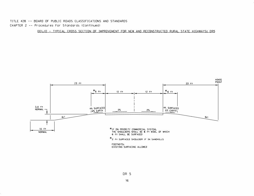
16
DR 5
10 ft
2.5 ft
NORMAL
23 ft
6 ft 12 ft 12 ft 6 ft
23 ft
6:1
IF ON PRIORITY COMMERCIAL SYSTEM,
THE SHOULDERS SHALL BE 8 ft WIDE, OF WHICH
6 ft SHALL BE SURFACED
2 ft SURFACED SHOULDER IF IN SANDHILLS
FOOTNOTE:
EXISTING SURFACING ALLOWED
6:1
*
HINGE
POINT
NORMAL
*
4% SURFACED6% EARTH2%2%
4% SURFACED
6% EARTH
*
TITLE 428 -- BOARD OF PUBLIC ROADS CLASSIFICATIONS AND STANDARDS
CHAPTER 2 -- Procedures For Standards (Continued)
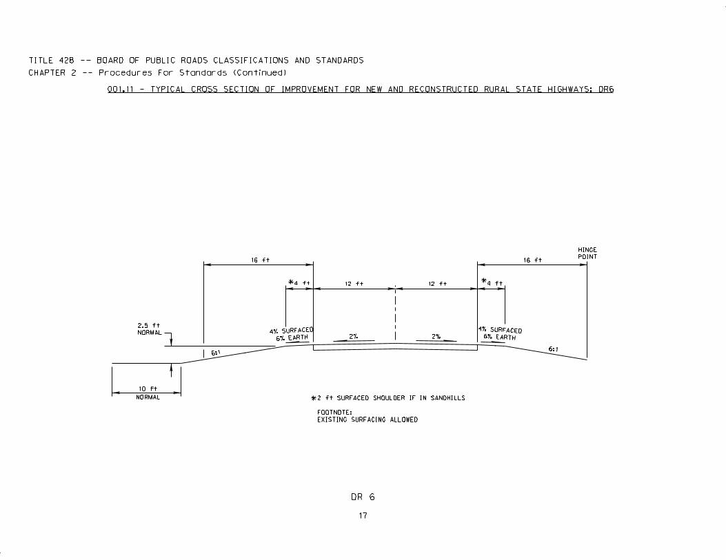
001.11 - TYPICAL CROSS SECTION OF IMPROVEMENT FOR NEW AND RECONSTRUCTED RURAL STATE HIGHWAYS: DR6
17
DR 6
10 ft
2.5 ft
NORMAL
16 ft
4 ft 12 ft 12 ft 4 ft
16 ft
6:1
2 ft SURFACED SHOULDER IF IN SANDHILLS
FOOTNOTE:
EXISTING SURFACING ALLOWED
Title 428 — BOARD OF PUBLIC ROADS CLASSIFICATIONS AND STANDARDS
Chapter 2 — Procedures for Standards (Continued)
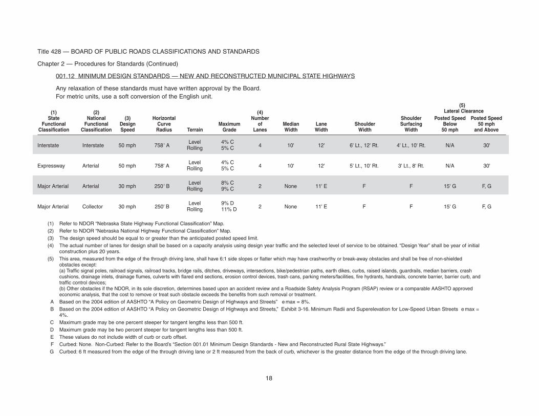
001.12 MINIMUM DESIGN STANDARDS — NEW AND RECONSTRUCTED MUNICIPAL STATE HIGHWAYS
Any relaxation of these standards must have written approval by the Board.For metric units, use a soft conversion of the English unit.
(5)(1) (2) (4) Lateral ClearanceState National (3) Horizontal Number Shoulder Posted Speed Posted Speed
Functional Functional Design Curve Maximum of Median Lane Shoulder Surfacing Below 50 mphClassification Classification Speed Radius Terrain Grade Lanes Width Width Width Width 50 mph and Above
Interstate Interstate 50 mph 758' ALevel 4% C
4 10' 12' 6' Lt., 12' Rt. 4' Lt., 10' Rt. N/A 30'Rolling 5% C
Expressway Arterial 50 mph 758' ALevel 4% C
4 10' 12' 5' Lt., 10' Rt. 3' Lt., 8' Rt. N/A 30'Rolling 5% C
Major Arterial Arterial 30 mph 250' BLevel 8% C
2 None 11' E F F 15' G F, GRolling 9% C
Major Arterial Collector 30 mph 250' BLevel 9% D
2 None 11' E F F 15' G F, GRolling 11% D
(1) Refer to NDOR “Nebraska State Highway Functional Classification” Map.(2) Refer to NDOR “Nebraska National Highway Functional Classification” Map.(3) The design speed should be equal to or greater than the anticipated posted speed limit.(4) The actual number of lanes for design shall be based on a capacity analysis using design year traffic and the selected level of service to be obtained. “Design Year” shall be year of initial
construction plus 20 years.(5) This area, measured from the edge of the through driving lane, shall have 6:1 side slopes or flatter which may have crashworthy or break-away obstacles and shall be free of non-shielded
obstacles except:(a) Traffic signal poles, railroad signals, railroad tracks, bridge rails, ditches, driveways, intersections, bike/pedestrian paths, earth dikes, curbs, raised islands, guardrails, median barriers, crashcushions, drainage inlets, drainage flumes, culverts with flared end sections, erosion control devices, trash cans, parking meters/facilities, fire hydrants, handrails, concrete barrier, barrier curb, andtraffic control devices;(b) Other obstacles if the NDOR, in its sole discretion, determines based upon an accident review and a Roadside Safety Analysis Program (RSAP) review or a comparable AASHTO approvedeconomic analysis, that the cost to remove or treat such obstacle exceeds the benefits from such removal or treatment.
A Based on the 2004 edition of AASHTO “A Policy on Geometric Design of Highways and Streets” e max = 8%.B Based on the 2004 edition of AASHTO “A Policy on Geometric Design of Highways and Streets,” Exhibit 3-16. Minimum Radii and Superelevation for Low-Speed Urban Streets e max =
4%.C Maximum grade may be one percent steeper for tangent lengths less than 500 ft.D Maximum grade may be two percent steeper for tangent lengths less than 500 ft.E These values do not include width of curb or curb offset.F Curbed: None. Non-Curbed: Refer to the Board’s “Section 001.01 Minimum Design Standards - New and Reconstructed Rural State Highways.”G Curbed: 6 ft measured from the edge of the through driving lane or 2 ft measured from the back of curb, whichever is the greater distance from the edge of the through driving lane.
18
Title 428 — BOARD OF PUBLIC ROADS CLASSIFICATIONS AND STANDARDS
Chapter 2 — Procedures for Standards (Continued)
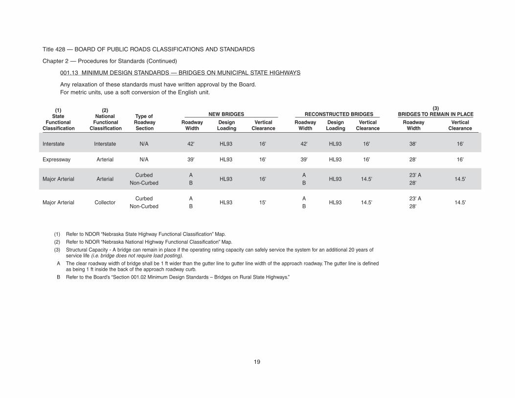
001.13 MINIMUM DESIGN STANDARDS — BRIDGES ON MUNICIPAL STATE HIGHWAYS
Any relaxation of these standards must have written approval by the Board.For metric units, use a soft conversion of the English unit.
(1) (2) (3)
State National Type of NEW BRIDGES RECONSTRUCTED BRIDGES BRIDGES TO REMAIN IN PLACE
Functional Functional Roadway Roadway Design Vertical Roadway Design Vertical Roadway VerticalClassification Classification Section Width Loading Clearance Width Loading Clearance Width Clearance
Interstate Interstate N/A 42' HL93 16' 42' HL93 16' 38' 16'
Expressway Arterial N/A 39' HL93 16' 39' HL93 16' 28' 16'
Major Arterial ArterialCurbed A
HL93 16'A
HL93 14.5'23' A
14.5'Non-Curbed B B 28'
Major Arterial CollectorCurbed A
HL93 15'A
HL93 14.5'23' A
14.5'Non-Curbed B B 28'
(1) Refer to NDOR “Nebraska State Highway Functional Classification” Map.
(2) Refer to NDOR “Nebraska National Highway Functional Classification” Map.
(3) Structural Capacity - A bridge can remain in place if the operating rating capacity can safely service the system for an additional 20 years ofservice life (i.e. bridge does not require load posting).
A The clear roadway width of bridge shall be 1 ft wider than the gutter line to gutter line width of the approach roadway. The gutter line is definedas being 1 ft inside the back of the approach roadway curb.
B Refer to the Board’s “Section 001.02 Minimum Design Standards – Bridges on Rural State Highways.”
19
20
Title 428 — BOARD OF PUBLIC ROADS CLASSIFICATIONS AND STANDARDS
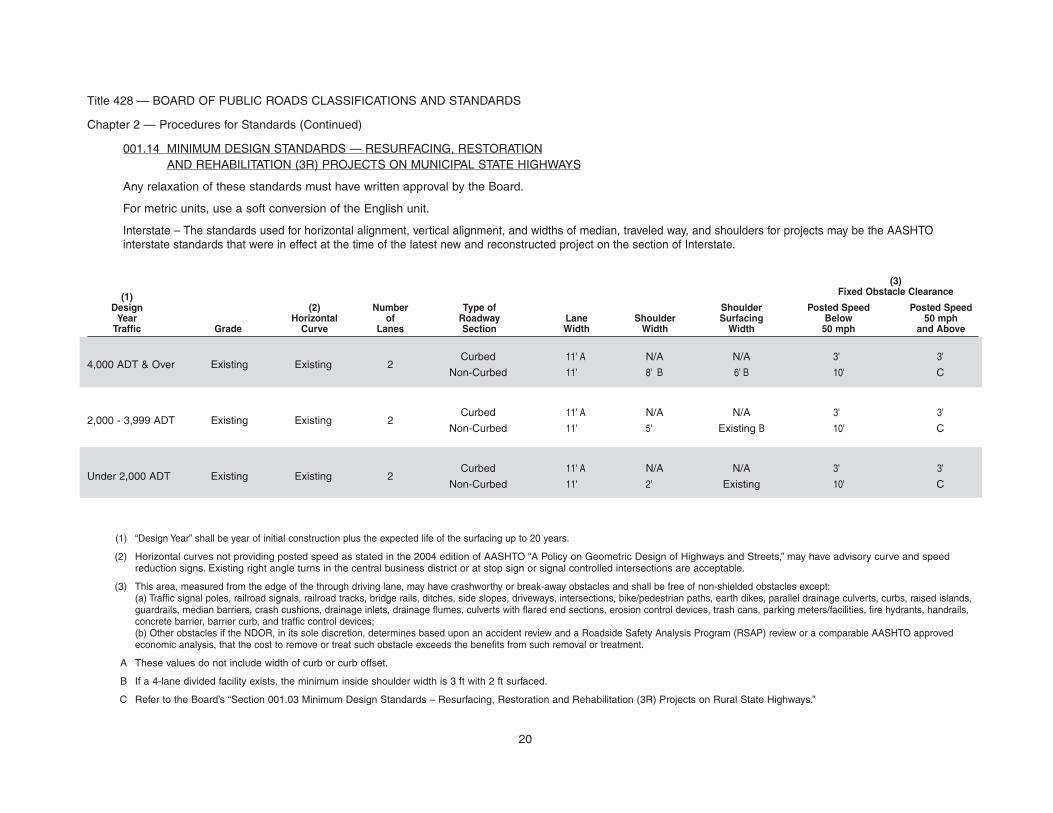
Chapter 2 — Procedures for Standards (Continued)
001.14 MINIMUM DESIGN STANDARDS — RESURFACING, RESTORATIONAND REHABILITATION (3R) PROJECTS ON MUNICIPAL STATE HIGHWAYS
Any relaxation of these standards must have written approval by the Board.
For metric units, use a soft conversion of the English unit.
Interstate – The standards used for horizontal alignment, vertical alignment, and widths of median, traveled way, and shoulders for projects may be the AASHTOinterstate standards that were in effect at the time of the latest new and reconstructed project on the section of Interstate.
(3)
(1) Fixed Obstacle Clearance
Design (2) Number Type of Shoulder Posted Speed Posted SpeedYear Horizontal of Roadway Lane Shoulder Surfacing Below 50 mphTraffic Grade Curve Lanes Section Width Width Width 50 mph and Above
4,000 ADT & Over Existing Existing 2Curbed 11' A N/A N/A 3' 3'
Non-Curbed 11' 8' B 6' B 10' C
2,000 - 3,999 ADT Existing Existing 2Curbed 11' A N/A N/A 3' 3'
Non-Curbed 11' 5' Existing B 10' C
Under 2,000 ADT Existing Existing 2Curbed 11' A N/A N/A 3' 3'
Non-Curbed 11' 2' Existing 10' C
(1) “Design Year” shall be year of initial construction plus the expected life of the surfacing up to 20 years.
(2) Horizontal curves not providing posted speed as stated in the 2004 edition of AASHTO “A Policy on Geometric Design of Highways and Streets,” may have advisory curve and speedreduction signs. Existing right angle turns in the central business district or at stop sign or signal controlled intersections are acceptable.
(3) This area, measured from the edge of the through driving lane, may have crashworthy or break-away obstacles and shall be free of non-shielded obstacles except:(a) Traffic signal poles, railroad signals, railroad tracks, bridge rails, ditches, side slopes, driveways, intersections, bike/pedestrian paths, earth dikes, parallel drainage culverts, curbs, raised islands,guardrails, median barriers, crash cushions, drainage inlets, drainage flumes, culverts with flared end sections, erosion control devices, trash cans, parking meters/facilities, fire hydrants, handrails,concrete barrier, barrier curb, and traffic control devices;(b) Other obstacles if the NDOR, in its sole discretion, determines based upon an accident review and a Roadside Safety Analysis Program (RSAP) review or a comparable AASHTO approvedeconomic analysis, that the cost to remove or treat such obstacle exceeds the benefits from such removal or treatment.
A These values do not include width of curb or curb offset.
B If a 4-lane divided facility exists, the minimum inside shoulder width is 3 ft with 2 ft surfaced.
C Refer to the Board’s “Section 001.03 Minimum Design Standards – Resurfacing, Restoration and Rehabilitation (3R) Projects on Rural State Highways.”

Part TwoLocal Roads and Streets
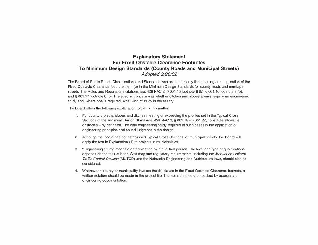
Explanatory StatementFor Fixed Obstacle Clearance Footnotes
To Minimum Design Standards (County Roads and Municipal Streets)Adopted 9/20/02
The Board of Public Roads Classifications and Standards was asked to clarify the meaning and application of theFixed Obstacle Clearance footnote, item (b) in the Minimum Design Standards for county roads and municipalstreets. The Rules and Regulations citations are: 428 NAC 2, § 001.15 footnote 8 (b), § 001.16 footnote 9 (b),and § 001.17 footnote 8 (b). The specific concern was whether ditches and slopes always require an engineeringstudy and, where one is required, what kind of study is necessary.
The Board offers the following explanation to clarify this matter.
1. For county projects, slopes and ditches meeting or exceeding the profiles set in the Typical CrossSections of the Minimum Design Standards, 428 NAC 2, § 001.18 - § 001.22, constitute allowableobstacles – by definition. The only engineering study required in such cases is the application ofengineering principles and sound judgment in the design.
2. Although the Board has not established Typical Cross Sections for municipal streets, the Board willapply the test in Explanation (1) to projects in municipalities.
3. “Engineering Study” means a determination by a qualified person. The level and type of qualificationsdepends on the task at hand. Statutory and regulatory requirements, including the Manual on UniformTraffic Control Devices (MUTCD) and the Nebraska Engineering and Architecture laws, should also beconsidered.
4. Whenever a county or municipality invokes the (b) clause in the Fixed Obstacle Clearance footnote, awritten notation should be made in the project file. The notation should be backed by appropriateengineering documentation.
21
Title 428 — BOARD OF PUBLIC ROADS CLASSIFICATIONS AND STANDARDS
Chapter 2 — Procedures for Standards (Continued)
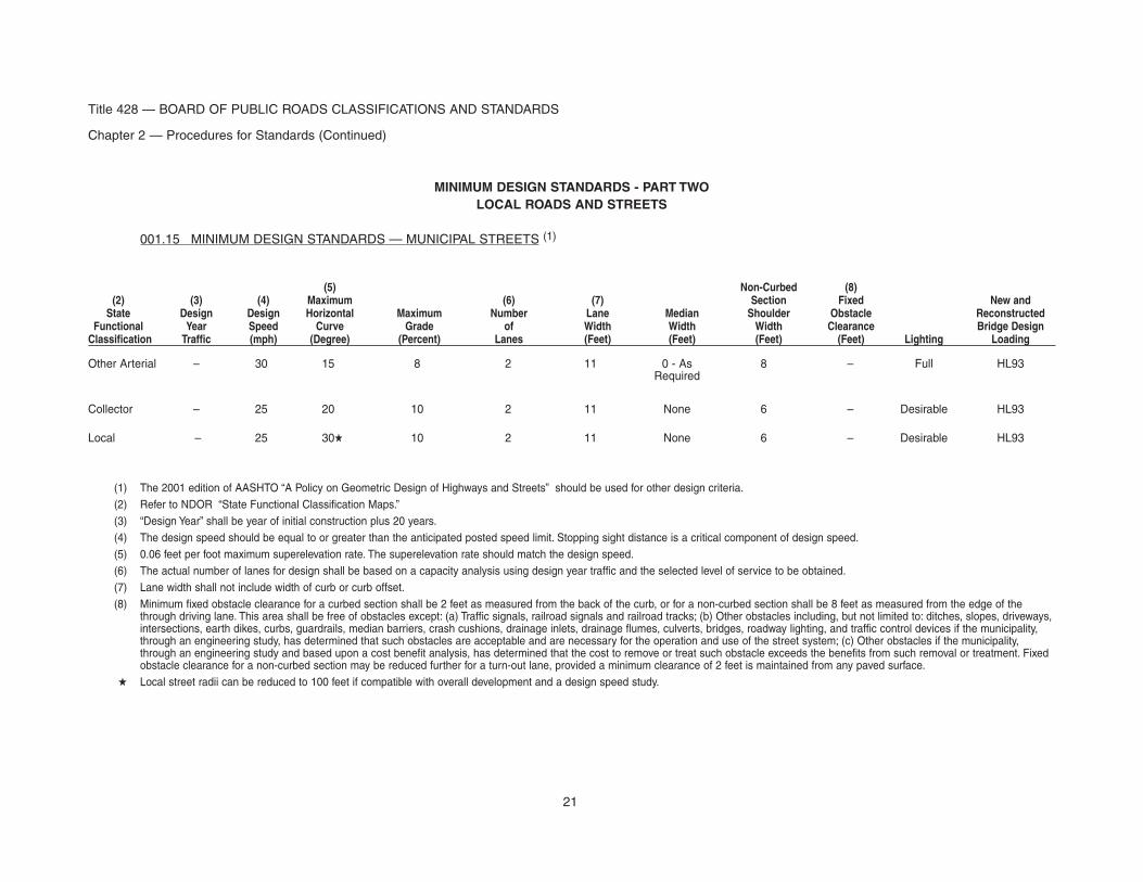
MINIMUM DESIGN STANDARDS - PART TWOLOCAL ROADS AND STREETS
001.15 MINIMUM DESIGN STANDARDS — MUNICIPAL STREETS (1)
(5) Non-Curbed (8)(2) (3) (4) Maximum (6) (7) Section Fixed New andState Design Design Horizontal Maximum Number Lane Median Shoulder Obstacle Reconstructed
Functional Year Speed Curve Grade of Width Width Width Clearance Bridge DesignClassification Traffic (mph) (Degree) (Percent) Lanes (Feet) (Feet) (Feet) (Feet) Lighting Loading
Other Arterial – 30 15 8 2 11 0 - As 8 – Full HL93Required
Collector – 25 20 10 2 11 None 6 – Desirable HL93
Local – 25 30� 10 2 11 None 6 – Desirable HL93
(1) The 2001 edition of AASHTO “A Policy on Geometric Design of Highways and Streets” should be used for other design criteria.(2) Refer to NDOR “State Functional Classification Maps.”(3) “Design Year” shall be year of initial construction plus 20 years.(4) The design speed should be equal to or greater than the anticipated posted speed limit. Stopping sight distance is a critical component of design speed.(5) 0.06 feet per foot maximum superelevation rate. The superelevation rate should match the design speed.(6) The actual number of lanes for design shall be based on a capacity analysis using design year traffic and the selected level of service to be obtained.(7) Lane width shall not include width of curb or curb offset.(8) Minimum fixed obstacle clearance for a curbed section shall be 2 feet as measured from the back of the curb, or for a non-curbed section shall be 8 feet as measured from the edge of the
through driving lane. This area shall be free of obstacles except: (a) Traffic signals, railroad signals and railroad tracks; (b) Other obstacles including, but not limited to: ditches, slopes, driveways,intersections, earth dikes, curbs, guardrails, median barriers, crash cushions, drainage inlets, drainage flumes, culverts, bridges, roadway lighting, and traffic control devices if the municipality,through an engineering study, has determined that such obstacles are acceptable and are necessary for the operation and use of the street system; (c) Other obstacles if the municipality,through an engineering study and based upon a cost benefit analysis, has determined that the cost to remove or treat such obstacle exceeds the benefits from such removal or treatment. Fixedobstacle clearance for a non-curbed section may be reduced further for a turn-out lane, provided a minimum clearance of 2 feet is maintained from any paved surface.
� Local street radii can be reduced to 100 feet if compatible with overall development and a design speed study.
Title 428 — BOARD OF PUBLIC ROADS CLASSIFICATIONS AND STANDARDS
Chapter 2 — Procedures for Standards (Continued)
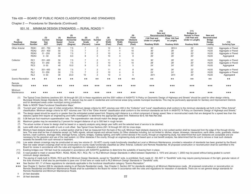
001.16 MINIMUM DESIGN STANDARDS — RURAL ROADS (1)(10) (11)
New and Bridges to(5) (9) Reconstructed Bridges Remain in Place New and
(3) (4) Maximum (6) (7) (8) Fixed (100 Feet and (Over 100 Feet (100 Feet and Reconstructed(2) Current Design Horizontal Maximum Number Lane Shoulder Obstacle Under in Length) in Length) Under in Length) Bridge
Roadway Design Year Speed Curve Grade of Width Width Clearance Design (12)Classification Number ADT (mph) (Degree) (Percent) Lanes (Feet) (Feet) (Feet) RoadwayWidth RoadwayWidth RoadwayWidth Loading Surfacing Type
Other Arterial ROA1 401 - 750 50 7.5 7 2 12 6 12 30' 28'�� 24' HL93 Aggregate or PavedROA2 251 - 400 50 7.5 7 2 11 4 10 30' 28' 22' HL93 Aggregate or PavedROA3 51 - 250 50 7.5 7 2 10 4 10 28' 28' 20' HL93 Aggregate or PavedROA4 0 - 50 40 8.0 8 2 10 3 8 26' 26' 20' HL93 Aggregate�
Collector RC1 251- 400 50 7.5 7 2 11 4 10 30' 28' 22' HL93 Aggregate or PavedRC2 51- 250 50 7.5 7 2 10 4 10 28' 28' 20' HL93 Aggregate or PavedRC3 0- 50 40 10.0 9 2 10 3 5 24' 24' 20' HL93 Aggregate�
Local RL1 251- 400 50 7.5 7 2 11 4 8 26' 26' 22' HL93 Aggregate or PavedRL2 51- 250 50 7.5 7 2 10 4 8 24' 24' 20' HL93 Aggregate or PavedRL3 0- 50 30 23.0 10 2 10 3 5 20'� 20'� 20' HL93 Aggregate�
Scenic-Recreation �� �� �� �� �� �� �� �� �� �� �� �� �� ��
RemoteResidential ��� ��� ��� ��� ��� ��� ��� ��� ��� ��� ��� ��� ��� ���
MinimumMaintenance ��� ��� ��� ��� ��� ��� ��� ��� ��� ��� ��� ��� ��� ���
(1) The Typical Cross Sections (sections 001.18 through 001.22) in these regulations and the 2001 edition of AASHTO “A Policy on Geometric Design of Highways and Streets” should be used for other design criteria.Municipal Streets Design Standards (Sec. 001.15, above) may be used in residential and commercial areas lying outside municipal boundaries. This may be particularly appropriate for Sanitary and Improvement Districtsand for developed areas under municipal zoning jurisdiction.
(2) Refer to NDOR “State Functional Classification Maps.”(3) “Current year” shall mean year of initial construction. Minimum design criteria for ADT volumes over 400 in the “Collector” and “Local” classifications shall conform to the minimum standards set forth in the “Other Arterial”
classification. Minimum design criteria for ADT volumes over 750 in the “Other Arterial” classification shall conform to the minimum standards set forth in AASHTO “A Policy on Geometric Design of Highways and Streets.”(4) The design speed should be equal to or greater than the anticipated posted speed limit. Stopping sight distance is a critical component of design speed. New or reconstructed roads that are designed for a speed less than the
statutory speed limit require an engineering and traffic investigation to determine the appropriate speed limit. Reference 60-6,190 Neb.Rev.Stat.(5) 0.08 feet per foot maximum superelevation rate. The superelevation rate should match the design speed.(6) Maximum grades may be exceeded by 2 percent for tangent distance of up to 500 feet in rough terrain.(7) The actual number of lanes for design shall be based on a capacity analysis using design year traffic and the selected level of service to be obtained.(8) Lane width shall not include width of curb or curb offset. See Typical Cross Sections (001.18 through 001.22) for cross slope.(9) Minimum fixed obstacle clearance for a curbed section shall be 2 feet as measured from the back of the curb. Minimum fixed obstacle clearance for a non-curbed section shall be measured from the edge of the through driving
lane. This area shall be free of obstacles except: (a) Traffic signals, railroad signals and railroad tracks; (b) Other obstacles including, but not limited to: ditches, slopes, driveways, intersections, earth dikes, curbs, guardrails, medianbarriers, crash cushions, drainage inlets, drainage flumes, culverts, bridges, roadway lighting, and traffic control devices if the county, through an engineering study, has determined that such obstacles are acceptable and arenecessary for the operation and use of the road system; (c) Other obstacles if the county, through an engineering study and based upon a cost benefit analysis, has determined that the cost to remove or treat such obstacleexceeds the benefits from such removal or treatment.
(10) Low water stream crossings may be constructed on very low volume (0 - 50 ADT) county roads functionally classified as Local or Minimum Maintenance, provided a relaxation of standards has been granted by the Board.New low water stream crossings shall not be constructed on county roads functionally classified as Other Arterial, Collector and Remote Residential. All proposed construction or reconstruction shall be submitted to theBoard for review in accordance with the rules and regulations for relaxation of standards.
(11) Existing bridges over 100 feet must be evaluated in accordance with AASHTO guidelines to determine the suitability of leaving them in place.(12) A road graded to meet or exceed ROA1, ROA2, ROA3, RC1, RC2, RL1 or RL2 Minimum Design Standards in effect between September 2, 1970 and January 1, 2003 may be paved without being graded to current
minimum design standards.� The paving of roads built to ROA4, RC3 and RL3 Minimum Design Standards, except for “Sandhills” soils, is prohibited. Such roads (0 - 50) ADT in “Sandhills” soils may require paving because of the light, granular nature of
the soils involved. It shall also be permissible to pave one 12-foot lane on roads built to RL3 Minimum Design Standards in “Sandhills” soils.�� See Section 001.17 of these regulations for standards applicable to the functional classification category “Scenic-Recreation.”
��� See Chapter 2, Section 006 for standards relating to all Remote Residential roads. See Chapter 2, Section 007 for standards relating to all Minimum Maintenance roads. All proposed construction or reconstruction onRemote Residential and Minimum Maintenance Roads shall be submitted to the Board for review in accordance with the rules and regulations for relaxation of standards. There are no set general design standards forRemote Residential and Minimum Maintenance Roads.
� 24 feet desirable�� 30 feet desirable 22
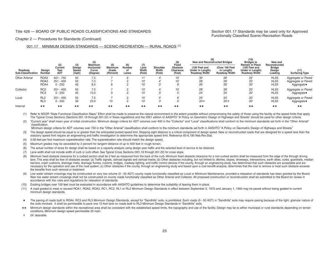
Title 428 — BOARD OF PUBLIC ROADS CLASSIFICATIONS AND STANDARDS
Chapter 2 — Procedures for Standards (Continued)
001.17 MINIMUM DESIGN STANDARDS — SCENIC-RECREATION — RURAL ROADS (1)
(9) (10)(4) (8) New and Reconstructed Bridges Bridges to New and
(2) (3) Maximum (5) (6) (7) Fixed Remain in Place ReconstructedCurrent Design Horizontal Maximum Number Lane Shoulder Obstacle (100 Feet and (Over 100 Feet (100 Feet and Bridge
Roadway Design Year Speed Curve Grade of Width Width Clearance Under in Length) in Length) Under in Length) Design (11)Sub-Classification Number ADT (mph) (Degree) (Percent) Lanes (Feet) (Feet) (Feet) RoadwayWidth RoadwayWidth RoadwayWidth Loading Surfacing Type
Other Arterial ROA2 401 - 750 50 7.5 7 2 11' 4' 10' 30' 28' 22' HL93 Aggregate or PavedROA3 251 - 400 50 7.5 7 2 10' 4' 10' 28' 28' 20' HL93 Aggregate or PavedROA4 0 - 250 40 8.0 8 2 10' 3' 9' 26' 26' 20' HL93 Aggregate�
Collector RC2 251 - 400 50 7.5 7 2 10' 4' 10' 28' 28' 20' HL93 Aggregate or PavedRC3 0 - 250 40 10.0 9 2 10' 3' 5' 24' 24' 20' HL93 Aggregate�
Local RL2 251 - 400 50 7.5 7 2 10' 4' 6' 24' 24' 20' HL93 Aggregate or PavedRL3 0 - 250 30 23.0 10 2 10' 3' 5' 20'� 20'� 20' HL93 Aggregate�
Internal �� �� �� �� �� �� �� �� �� �� �� �� �� ��
(1) Refer to NDOR “State Functional Classification Maps.” Effort shall be made to preserve the natural environment to the extent possible without compromising the safety of those using the facility at the speed limits that apply.The Typical Cross Sections (Sections 001.19 through 001.22) in these regulations and the 2001 edition of AASHTO “A Policy on Geometric Design of Highways and Streets” should be used for other design criteria.
(2) “Current year” shall mean year of initial construction. Minimum design criteria for ADT volumes over 400 in the “Collector” and “Local” classifications shall conform to the minimum standards set forth in the “Other Arterial”classification.Minimum design criteria for ADT volumes over 750 in the “Other Arterial” classification shall conform to the minimum standards set forth in AASHTO “A Policy on Geometric Design of Highways and Streets.”
(3) The design speed should be equal to or greater than the anticipated posted speed limit. Stopping sight distance is a critical component of design speed. New or reconstructed roads that are designed for a speed less than thestatutory speed limit require an engineering and traffic investigation to determine the appropriate speed limit. Reference 60-6,190 Neb.Rev.Stat.
(4) 0.08 feet per foot maximum superelevation rate. The superelevation rate should match the design speed.(5) Maximum grades may be exceeded by 2 percent for tangent distance of up to 500 feet in rough terrain.(6) The actual number of lanes for design shall be based on a capacity analysis using design year traffic and the selected level of service to be obtained.(7) Lane width shall not include width of curb or curb offset. See Typical Cross Sections (001.19 through 001.22) for cross slope.(8) Minimum fixed obstacle clearance for a curbed section shall be 2 feet as measured from the back of the curb. Minimum fixed obstacle clearance for a non-curbed section shall be measured from the edge of the through driving
lane. This area shall be free of obstacles except: (a) Traffic signals, railroad signals and railroad tracks; (b) Other obstacles including, but not limited to: ditches, slopes, driveways, intersections, earth dikes, curbs, guardrails, medianbarriers, crash cushions, drainage inlets, drainage flumes, culverts, bridges, roadway lighting, and traffic control devices if the county, through an engineering study, has determined that such obstacles are acceptable and arenecessary for the operation and use of the road system; (c) Other obstacles if the county, through an engineering study and based upon a cost benefit analysis, determines that the cost to remove or treat such obstacle exceedsthe benefits from such removal or treatment.
(9) Low water stream crossings may be constructed on very low volume (0 - 50 ADT) county roads functionally classified as Local or Minimum Maintenance, provided a relaxation of standards has been granted by the Board.New low water stream crossings shall not be constructed on county roads functionally classified as Other Arterial and Collector. All proposed construction or reconstruction shall be submitted to the Board for review inaccordance with the rules and regulations for relaxation of standards.
(10) Existing bridges over 100 feet must be evaluated in accordance with AASHTO guidelines to determine the suitability of leaving them in place.(11) A road graded to meet or exceed ROA1, ROA2, ROA3, RC1, RC2, RL1 or RL2 Minimum Design Standards in effect between September 2, 1970 and January 1, 1993 may be paved without being graded to current
minimum design standards.
� The paving of roads built to ROA4, RC3 and RL3 Minimum Design Standards, except for “Sandhills” soils, is prohibited. Such roads (0 - 50 ADT) in “Sandhills” soils may require paving because of the light, granular nature ofthe soils involved. It shall be permissible to pave one 12-foot lane on roads built to RL3 Minimum Design Standards in “Sandhills” soils.
�� Minimum design standards within the recreational area shall be consistent with the established speed limits, the topography and use of the facility. Design may be to either municipal or rural standards depending on terrainconditions. Minimum design speed permissible 20 mph.
� 24' desirable
Section 001.17 Standards may be used only for ApprovedFunctionally Classified Scenic-Recreation Roads
23
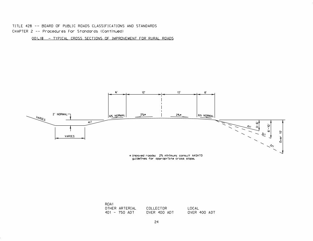
4:1
3:1
6’ 12’ 12’ 6’
6% NORMAL 6% NORMAL2%* 2%*
4:1
VARIES
2’ NORMAL
VARIES
0-6’
6’-1
0’
2:1
Ov
er 1
0’
ROA1
OTHER ARTERIAL
401 - 750 ADT
COLLECTOR
OVER 400 ADT
LOCAL
OVER 400 ADT
TITLE 428 -- BOARD OF PUBLIC ROADS CLASSIFICATIONS AND STANDARDS
CHAPTER 2 -- Procedures For Standards (Continued)
001.18 - TYPICAL CROSS SECTIONS OF IMPROVEMENT FOR RURAL ROADS
24
Unpaved roads: 2% minimum; consult AASHTO
guidelines for appropriate cross slope.
*
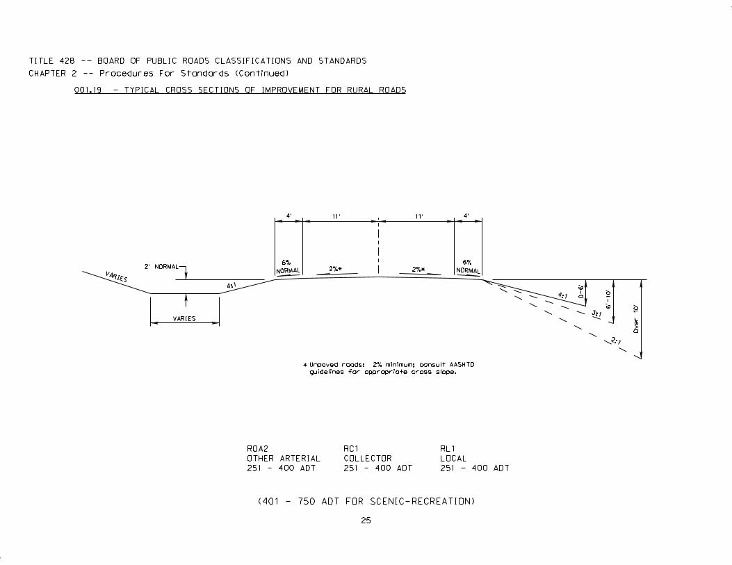
4:1
3:1
25
4’ 11’ 11’
2%* 2%*
4:1
VARIES
2’ NORMAL
VARIES
0-6’
6’-1
0’
2:1
6%
NORMAL
4’
6%
NORMAL
Ov
er 1
0’
TITLE 428 -- BOARD OF PUBLIC ROADS CLASSIFICATIONS AND STANDARDS
CHAPTER 2 -- Procedures For Standards (Continued)
Unpaved roads: 2% minimum; consult AASHTO
guidelines for appropriate cross slope.
*
001.19 - TYPICAL CROSS SECTIONS OF IMPROVEMENT FOR RURAL ROADS
ROA2
OTHER ARTERIAL
251 - 400 ADT
RC1
COLLECTOR
251 - 400 ADT
RL1
LOCAL
251 - 400 ADT
(401 - 750 ADT FOR SCENIC-RECREATION)
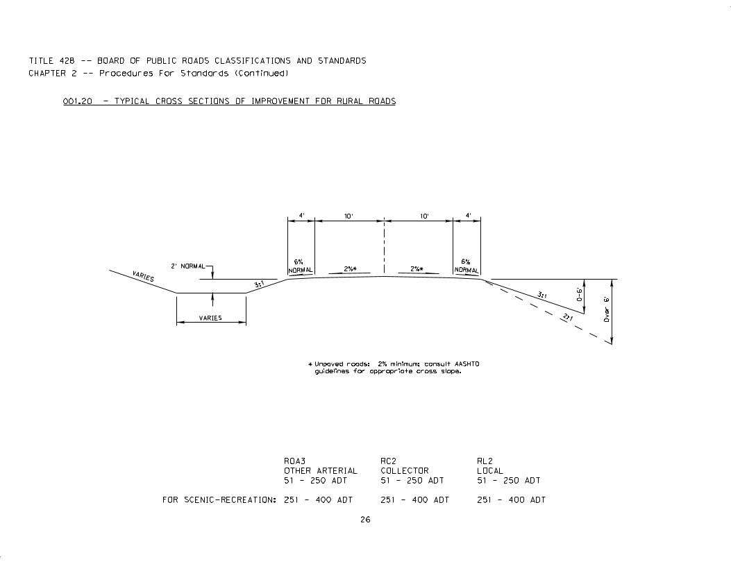
3:1
26
4’ 10’ 10’
2%*
VARIES
2’ NORMAL
VARIES
0-6’
2:1
6%
NORMAL
4’
6%
NORMAL
3:1
2%*
Over 6
’
TITLE 428 -- BOARD OF PUBLIC ROADS CLASSIFICATIONS AND STANDARDS
CHAPTER 2 -- Procedures For Standards (Continued)
Unpaved roads: 2% minimum; consult AASHTO
guidelines for appropriate cross slope.
*
001.20 - TYPICAL CROSS SECTIONS OF IMPROVEMENT FOR RURAL ROADS
ROA3
OTHER ARTERIAL
51 - 250 ADT
RC2
COLLECTOR
51 - 250 ADT
RL2
LOCAL
51 - 250 ADT
251 - 400 ADT 251 - 400 ADT 251 - 400 ADTFOR SCENIC-RECREATION:
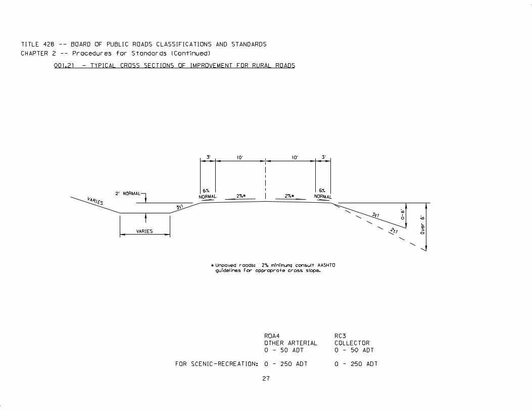
3:1
27
3’ 10’ 10’
2%*
VARIES
2’ NORMAL
VARIES
0-6’
2:1
6%
NORMAL
3:1
2%*
3’
6%
NORMAL
Over 6
’
TITLE 428 -- BOARD OF PUBLIC ROADS CLASSIFICATIONS AND STANDARDS
CHAPTER 2 -- Procedures for Standards (Continued)
Unpaved roads: 2% minimum; consult AASHTO
guidelines For approprate cross slope.
*
001.21 - TYPICAL CROSS SECTIONS OF IMPROVEMENT FOR RURAL ROADS
FOR SCENIC-RECREATION: 0 - 250 ADT 0 - 250 ADT
ROA4
OTHER ARTERIAL
0 - 50 ADT
RC3
COLLECTOR
0 - 50 ADT
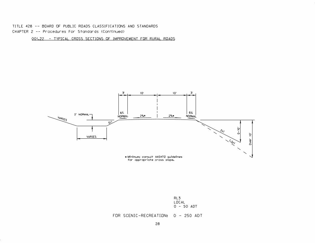
28
3’ 10’ 10’
2%*
VARIES
2’ NORMAL
VARIES
2:1
6%
NORMAL 2%*
3’
6%
NORMAL
2:1
0-1
0’
1.5:1
*
Over 1
0’
Minimum; consult AASHTO guidelines
for appropriate cross slope.
TITLE 428 -- BOARD OF PUBLIC ROADS CLASSIFICATIONS AND STANDARDS
CHAPTER 2 -- Procedures For Standards (Continued)
001.22 - TYPICAL CROSS SECTIONS OF IMPROVEMENT FOR RURAL ROADS
RL3
LOCAL
0 - 50 ADT
FOR SCENIC-RECREATION: 0 - 250 ADT
Title 428 – BOARD OF PUBLIC ROADS CLASSIFICATIONS AND STANDARDS Chapter 2 – Procedures for Standards (Continued)
29
002 MINIMUM CONSTRUCTION STANDARDS
002.01 RURAL HIGHWAYS – 39-2103 NEB. REV. STAT.
002.01A Functional Classifications – (1) Interstate, (2) Expressway, (3) Major Arterial, (4) Other Arterial, and (5) Collector shall require all construction to be in accordance with the State of Nebraska, Department of Roads, Bureau of Highways 1973 Standard Specifications for Highway Construction.
002.01B Functional Classification – (6) Local, shall require that all construction follow the State of Nebraska, Department of Roads, Bureau of Highways 1973 Standard Specifications for Highway Construction, as a guide to good construction methods. However, the minimum design standards shall govern the type and shape of construction and the Licensed or Certified County Highway Superintendent or an individual appointed by the County Board shall have the responsibility to see that acceptable materials are furnished and properly placed.
002.02 MUNICIPAL STREETS – 39-2104 NEB. REV. STAT.
002.02A Functional Classifications – (1) Interstate, (2) Expressway, (3) Major Arterial, (4) Other Arterial, and (5) Collector shall require all construction to be in accordance with the state of Nebraska, Department of Roads, Bureau of Highways 1973 Standard Specifications for Highway Construction.
002.02B Functional Classification – (6) Local shall require that all construction follow the State of Nebraska, Department of Roads, Bureau of Highways 1973 Standard Specifications for Highway Construction, as a guide to good construction methods. However, the minimum design standards shall govern the type and shape of construction and the Public Works Director or Licensed or Certified City Street Superintendent shall have the responsibility to see that acceptable materials are furnished and properly placed.
002.03 ANY COUNTY OR MUNICIPALITY MAY BE PERMITTED TO USE THEIR OWN SPECIFICATIONS IF SUCH SPECIFICATIONS HAVE BEEN PREVIOUSLY SUBMITTED TO THE BOARD AND FOUND BY THE BOARD TO BE SUBSTANTIALLY EQUAL TO THE STATE OF NEBRASKA, DEPARTMENT OF ROADS, BUREAU OF HIGHWAYS 1973 STANDARD SPECIFICATIONS FOR HIGHWAY CONSTRUCTION.
Title 428 – BOARD OF PUBLIC ROADS CLASSIFICATIONS AND STANDARDS Chapter 2 – Procedures for Standards (Continued)
30
003 MINIMUM MAINTENANCE STANDARDS. Applicable to each functional classification set forth in Chapter 39, Article 21 Neb. Rev. Stat., except Remote Residential and Minimum Maintenance Roads.
003.01 DEFINITION. Maintenance is defined as the preservation and upkeep of a highway or street including all its elements, in a condition as near as is practical to the original or as constructed condition in order to provide the road user with a safe and convenient highway facility.
003.02 LIMITS OF MAINTENANCE. Routine Maintenance funds should be used only for the restoration and repair of the travel way to the safe and usable condition to which it was constructed and for limited roadside maintenance such as mowing the shoulders of the road, filling shoulder washes, cleaning ditches and backfilling small slides or washouts.
003.03 PHYSICAL MAINTENANCE. The following routine maintenance operations, replacements, and minor additions, although not all inclusive, are considered to be physical maintenance.
003.03A ROADWAY SURFACES
- Scarifying, reshaping, and restoring material losses. - Applying dust palliatives. - Patching, repairing, surface treating, joint filling, and mudjacking on bituminous or
concrete surfaces. - Resurfacing or concrete, brick, or bituminous pavements with bituminous material. - Replacement of traveled way and shoulder in kind. - Replacement of unsuitable base materials in patching operations.
003.03B SHOULDERS AND SIDE ROAD APPROACHES
- Scarifying, reshaping and restoring material losses. - Applying dust palliatives. - Patching and repairing all bituminous types, including base. - Resealing bituminous types. - Reseeding and resodding.
003.03C ROADSIDE AND DRAINAGE - Reshaping of drainage channels and sideslopes. - Restoration of erosion controls. - Cleaning and repairing culverts. - Removing slides. - Mowing and tree trimming. - Replacing topsoil, sod, shrubs, etc. - Replacement, with essentially the same design, or curb, gutter, riprap, underdrain, and culverts.
Title 428 – BOARD OF PUBLIC ROADS CLASSIFICATIONS AND STANDARDS Chapter 2 – Procedures for Standards (Continued)
31
003.03D STRUCTURES
- Cleaning, painting, and repairing. - Replacements, with essentially the same design, or rails, floors, stringers, and beams. - Replacement of walls in kind.
003.03E The replacements and additions of a minor nature as listed above are considered to be physical maintenance. Where they become extensive or costly, such operations should not be charged to maintenance but to construction.
003.04 TRAFFIC SERVICES. The following maintenance operations, although not all inclusive, are considered to be traffic services to the public.
003.04A SNOW
All operations resulting from snow, such as erection of snow fences to minimize snowdrifts and the actual removal of snow from the traveled way.
003.04B ICE
All operations to reduce hazard due to icing of the roadway surface; such as, sanding, the application of chemicals to lower melting point, opening of inlets, actual removal of ice as by scraping, and in some instances the supplying of heat.
003.04C TRAFFIC CONTROL AND SERVICE FACILITIES
- Painting of pavement stripes and markings. - Painting, repairing, and replacement in kind of signs, guardrail,
traffic signals, lighting standards, etc. - Maintaining rest areas. - Replacement of roadside rest areas in kind. - Additions of small numbers of conventional traffic control devices, including signs. - Servicing highway lighting and traffic control devices. - Painting, The furnishing of power for highway lighting and traffic control devices and the
regular replacement of parts such as light bulbs.
003.04D ROAD SERVICES
The cost of services performed directly for road users, among which are supervision of roadside rest areas, cleaning operations on roadsides, motor vehicle repair and towing services, and operation of information booths.
003.05 UNUSUAL OR DISASTER OPERATIONS. Extensive repair or replacement due to damage as a result of storm, flood, or military operations may be considered as extraordinary maintenance, betterment, reconstruction, or even as construction. Each case should be considered separately and usually it is advantageous to keep all such accounts together under the heading of Unusual or Disaster Operations.
Title 428 – BOARD OF PUBLIC ROADS CLASSIFICATIONS AND STANDARDS Chapter 2 – Procedures for Standards (Continued)
32
004 RELAXATION OF STANDARDS
004.01 Whenever the application of standards of design, construction, or maintenance, as promulgated by the Board of Public Roads Classifications and Standards, works a special hardship on any segment of highway, road, or street, a county or municipality may request that the Board relax the standards for such segment.
004.01A All requests for relaxation of standards must be in writing and must be filed with the Secretary of the Board.
All county requests for relaxation of standards must be made by the County Highway Superintendent for that county, or in counties lacking such officer, by the person responsible for the county highway program. All municipal requests for relaxation of standards must be made by the City Street Superintendent for that municipality, or in municipalities lacking such officer, by the person responsible for the municipal street program. Each request will include a certification of approval of the request by the county commissioners of the requesting county or the city council of the requesting municipality.
All requests will specify in detail what peculiar, special or unique local situations would make the application of the standards not feasible.
004.01B Upon receipt of a request, the Secretary of the Board will set a hearing date for the request. The hearing date will be within sixty days of the filing of the request, and notice will be given to the requesting county or municipality at least ten days prior to the hearing.
004.01C Upon the date of the hearing, the board will meet, consider the request, and by vote, grant or deny the request either in whole or in part. An affirmative vote of at least six members will be necessary to grant a request. A permanent record will be maintained of the board’s decision. A copy will be distributed to the requesting county or municipality, to the Department of Roads, and to any interested party requesting a record of the proceeding.
004.02 Low water stream crossings may be constructed on very low volume county roads functionally classified as Local or Minimum Maintenance provided the road is not the only access to an occupied dwelling.
New construction of low water stream crossings and fords shall not be permitted on county roads functionally classified as Other Arterial and Collector. Continuation of and maintenance of existing low water stream crossings and fords working satisfactorily will be permitted.
A low water stream crossing shall be defined as a stream crossing structure that is designed and constructed so that it shall convey the normal stream flow below the driving surface, but normally will be overtopped by floods at least once annually.
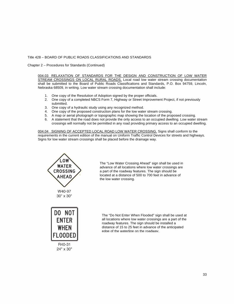
Title 428 – BOARD OF PUBLIC ROADS CLASSIFICATIONS AND STANDARDS Chapter 2 – Procedures for Standards (Continued)
33
004.03 RELAXATION OF STANDARDS FOR THE DESIGN AND CONSTRUCTION OF LOW WATER STREAM CROSSINGS ON LOCAL RURAL ROADS. Local road low water stream crossing documentation shall be submitted to the Board of Public Roads Classifications and Standards, P.O. Box 94759, Lincoln, Nebraska 68509, in writing. Low water stream crossing documentation shall include:
1. One copy of the Resolution of Adoption signed by the proper officials. 2. One copy of a completed NBCS Form 7, Highway or Street Improvement Project, if not previously
submitted. 3. One copy of a hydraulic study using any recognized method. 4. One copy of the proposed construction plans for the low water stream crossing. 5. A map or aerial photograph or topographic map showing the location of the proposed crossing. 6. A statement that the road does not provide the only access to an occupied dwelling. Low water stream
crossings will normally not be permitted in any road providing primary access to an occupied dwelling.
004.04 SIGNING OF ACCEPTED LOCAL ROAD LOW WATER CROSSING. Signs shall conform to the requirements in the current edition of the manual on Uniform Traffic Control Devices for streets and highways. Signs for low water stream crossings shall be placed before the drainage way.
The “Low Water Crossing Ahead” sign shall be used in advance of all locations where low water crossings are a part of the roadway features. The sign should be located at a distance of 500 to 700 feet in advance of the low water crossing.
The “Do Not Enter When Flooded” sign shall be used at all locations where low water crossings are a part of the roadway features. The sign should be installed a distance of 15 to 25 feet in advance of the anticipated edge of the waterline on the roadway.
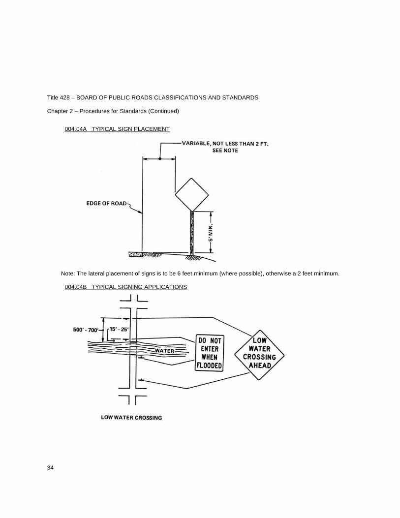
Title 428 – BOARD OF PUBLIC ROADS CLASSIFICATIONS AND STANDARDS Chapter 2 – Procedures for Standards (Continued)
34
004.04A TYPICAL SIGN PLACEMENT
Note: The lateral placement of signs is to be 6 feet minimum (where possible), otherwise a 2 feet minimum.
004.04B TYPICAL SIGNING APPLICATIONS
Title 428 – BOARD OF PUBLIC ROADS CLASSIFICATIONS AND STANDARDS Chapter 2 – Procedures for Standards (Continued)
35
004.05 REQUIRED MAINTENANCE. Low water stream crossings shall be inspected at regular intervals by a qualified county or township official to see if an actual hazard exists and if discovered these shall be repaired. All signs shall be kept in good condition and replaced if necessary as signing is essential for the safe operation of these low water stream crossings.
004.06 REVIEW OF STANDARDS FOR THE DESIGN AND CONSTRUCTION OR RECONSTRUCTION OF LOW WATER STREAM CROSSINGS OR FORDS ON MINIMUM MAINTENANCE RURAL ROADS. Minimum maintenance low water stream crossing documentation shall be submitted to the Board of Public Roads Classifications and Standards in writing. Low water stream crossing documentation shall include:
1. One copy of the Resolution of Adoption signed by the proper officials. 2. One copy of a completed NBCS Form 7, Highway or Street Improvement Project, if not previously
submitted. 3. A hydraulic study using any recognized method is optional. If a study was conducted, submit one
copy. 4. One copy of the proposed construction/reconstruction plans or sketch or drawing sufficient to show
what is being proposed for the low water stream crossing or ford. 5. A map or aerial photograph or topographic map showing the location of the proposed crossing.
Title 428 – BOARD OF PUBLIC ROADS CLASSIFICATIONS AND STANDARDS Chapter 2 – Procedures for Standards (Continued)
36
005 RELAXATION OF STANDARDS FOR SCENIC-RECREATION ROADS
005.01 Whenever the application of standards of design, construction, or maintenance, as promulgated by the Board of Public Roads Classifications and Standards, work a special hardship on any segment of highway, road, or street, or would defeat the purpose of the scenic-recreation functional classification, a county, municipality or other interested party may request that the Board relax the standards for such segment. 005.02 Jurisdictional responsibility for all scenic-recreation roads and highways shall remain with the governmental subdivision which had jurisdictional responsibility for such road or highway prior to its change in classification to scenic-recreation. 005.03 A request for relaxation of standards for a scenic-recreation highway, road or street by any county, municipality or other interested party shall be submitted to the Board of Public Roads Classifications and Standards in writing. Request documentation shall include:
1. One copy stating what application of such standard would defeat the purpose of the scenic-recreation functional classification.
2. One copy of a map showing the location of the highway, road or street together with beginning and
ending points. 3. Traffic count data including location of traffic count station(s) and date(s). 4. One copy of a certification of approval or disapproval of the request by the governing body having
jurisdictional responsibility for that segment of highway, road or street.
005.04 Upon receipt of a request, the Secretary of the Board will set a hearing date for the request. The hearing date will be within sixty days of the filing of the request, and notice will be given to the requesting county, municipality or other interested party at least ten days prior to the hearing. 005.05 Upon the date of the hearing, the Board will meet, consider the request, and by Roll Call vote, grant or deny the request either in whole or in part. An affirmative vote of at least six members will be necessary to grant a request. A permanent record will be maintained of the Board’s decision. A copy will be distributed to the requesting county or municipality, to the Department of Roads, and to any interested party requesting a record of the proceeding.
Title 428 – BOARD OF PUBLIC ROADS CLASSIFICATIONS AND STANDARDS Chapter 2 – Procedures for Standards (Continued)
37
006 MINIMUM STANDARDS FOR REMOTE RESIDENTIAL ROADS
006.01 DESIGN AND CONSTRUCTION STANDARDS RESTRICTIONS. If a county wants to construct a new segment of Remote Residential Road or an extension to an existing segment of Remote Residential Road, or reconstruct an existing segment of a Remote Residential Road, or when a county wants an existing non-surfaced road segment or an existing one-lane road segment with inadequate sight distance reclassified to Remote Residential, the county proposal for design and construction shall be submitted to the Board of Public Roads Classifications and Standards for review prior to the start of construction in accordance with the rules and regulations for a Relaxation of Standards.
006.01A MINIMUM SUFACING WIDTH AND TYPE. One 12-foot lane width of crushed aggregate surfacing of any type will be allowed where sight distance is adequate to warn motorist of oncoming traffic. Refer to the 2001 edition of AASHTO “Guidelines for Geometric Design of Very Low-Volume Local Roads (ADT 400)” for information on sight distance.
006.01B NEW AND REPLACEMENT STRUCTURES.
006.01B1 New and reconstructed bridge Design Loading: HL93.
006.01B2 New construction of low water stream crossings and fords shall not be permitted on county roads functionally classified Remote Residential. Continuation of and maintenance of existing low water stream crossings and fords working satisfactorily will be permitted. A low water stream crossing shall be defined as a stream crossing structure that is designed and constructed so that it shall convey the normal stream flow below the driving surface, but normally will be overtopped by floods at least once annually.
006.02 MAINTENANCE
006.02A DEFINITION. For purposes of Section 006 of these regulations, maintenance shall be defined to require only those activities and services necessary to provide access to remote residences, farms and ranches by passenger and commercial vehicles.
006.02B LIMITS OF MAINTENANCE. Routine Maintenance Funds should only be used for the restoration and repair of the travel way to the safe and usable condition to which it was constructed and for limited roadside maintenance such as mowing the shoulders of the road, filling shoulder washes, cleaning ditches and backfilling small slides or washouts. On existing aggregate surfaced or paved surfaced roads reclassified to Remote Residential, maintenance includes maintaining the travel way and surfacing width that existed at the time the road was reclassified or converting all or part of the existing pavement to crushed aggregate of any type, provided the existing travel way and surfacing width is maintained.
Title 428 – BOARD OF PUBLIC ROADS CLASSIFICATIONS AND STANDARDS Chapter 2 – Procedures for Standards (Continued)
38
006.02C SIGNING OF REMOTE RESIDENTIAL ROADS. The County shall install and maintain, at entry points to Remote Residential Roads, appropriate signs to adequately warn members of the public that they are traveling on a one-lane road. Such signs shall conform to the requirements in the Manual on Uniform Traffic Control Devices adopted pursuant to Chapter 60, Section 60-6,118 Nebraska Revised Statutes.
Title 428 – BOARD OF PUBLIC ROADS CLASSIFICATIONS AND STANDARDS Chapter 2 – Procedures for Standards (Continued)
39
007 MAINTENANCE STANDARDS FOR MINIMUM MAINTENANCE ROADS
007.01 DEFINITION. Maintenance shall be defined as providing only those activities and services required for the usage by farm machinery and occasional or intermittent use by passenger or commercial vehicles.
007.02 LIMITS OF MAINTENANCE. Funds can be used to provide for repair and restoration of culverts and bridges only if required for safe passage of the occasional usage.
Snow plowing, placement of any surfacing material, including gravel or crushed rock and mowing of the roadway is not required for this classification of road, however, roadway mowing may be necessary in order to provide for safety at intersections and to permit passing.
007.03 REPLACEMENT STRUCTURES. Any defective bridge or culvert or other such structure on, in, over, or under the roadway may be removed and not replaced in order to protect the public safety. Structures to be built, or rebuilt will only be those that are determined by the county board to be essential for the public safety or for the present or future transportation needs of the county.
Removed structures may be replaced by a ford or low water stream crossing that will permit crossing in dry weather and is intended to convey water across the roadway rather than carrying the water under the roadway. These fords shall be so constructed that they shall not constrict the passage of water across the roadway thereby causing water to backup on the adjacent properties during normally expected rainfalls. These fords may have hard surfacing placed to facilitate passage of vehicles through the waterway. The County proposal for new or replacement structures, low water crossings and fords shall be submitted to the Board of Public Roads Classifications and Standards for review in accordance with the rules and regulations for relaxation of standards.
A low water stream crossing shall be defined as a stream crossing structure that is designed and constructed so that it shall convey the normal stream flow below the driving surface, but normally will be overtopped by floods at least once annually.
007.04 SIGNING OF MINIMUM MAINTENANCE ROADS. The installation of signs shall be at the beginning and end of minimum maintenance routes and at any other public access along the route. In the event the minimum maintenance route exceeds five miles in length with no intermediate public access then a minimum maintenance sign shall be placed at an interval not to exceed five miles. These signs shall provide warning to the public that a lower level of maintenance exists for the designated section of roadway than is normal for that county. These signs shall conform to the requirements in the current edition of the Manual on Uniform Traffic Control Devices for Streets and Highways. These signs shall indicate a lower maintenance level and shall indicate if the road is a through route or has no exit where it terminates at a property line and not at a connecting public road.
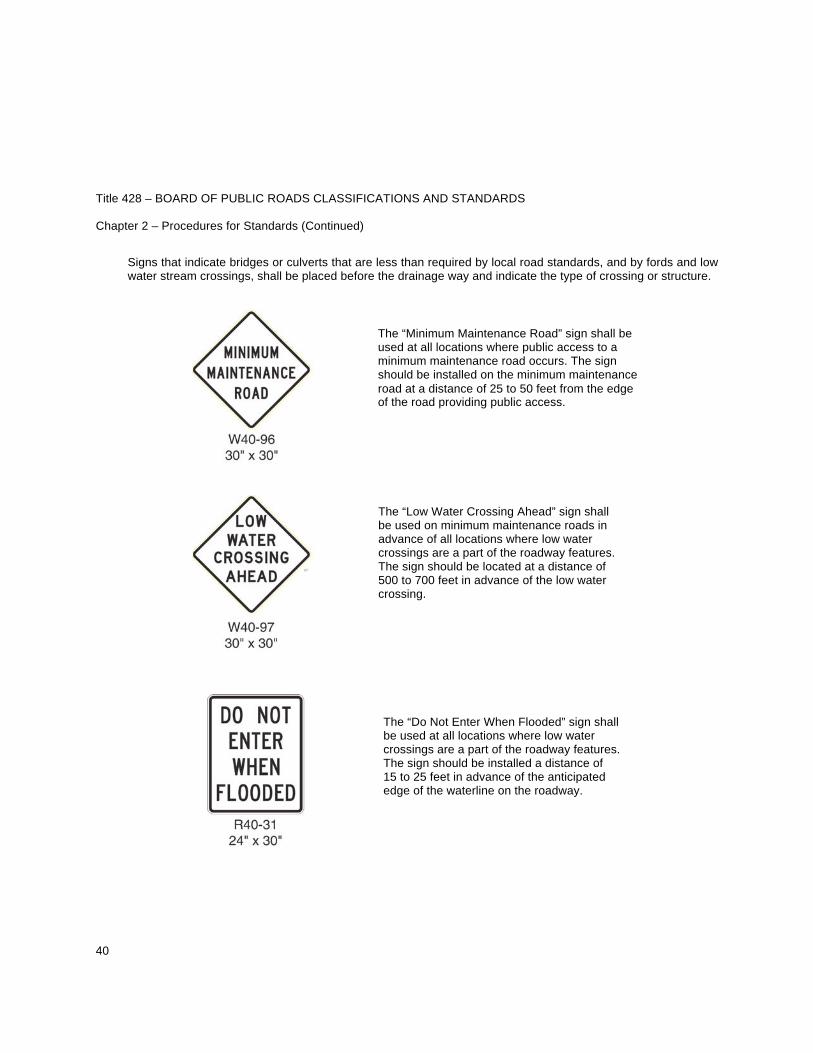
Title 428 – BOARD OF PUBLIC ROADS CLASSIFICATIONS AND STANDARDS Chapter 2 – Procedures for Standards (Continued)
40
Signs that indicate bridges or culverts that are less than required by local road standards, and by fords and low water stream crossings, shall be placed before the drainage way and indicate the type of crossing or structure.
The “Minimum Maintenance Road” sign shall be used at all locations where public access to a minimum maintenance road occurs. The sign should be installed on the minimum maintenance road at a distance of 25 to 50 feet from the edge of the road providing public access.
The “Low Water Crossing Ahead” sign shall be used on minimum maintenance roads in advance of all locations where low water crossings are a part of the roadway features. The sign should be located at a distance of 500 to 700 feet in advance of the low water crossing.
The “Do Not Enter When Flooded” sign shall be used at all locations where low water crossings are a part of the roadway features. The sign should be installed a distance of 15 to 25 feet in advance of the anticipated edge of the waterline on the roadway.
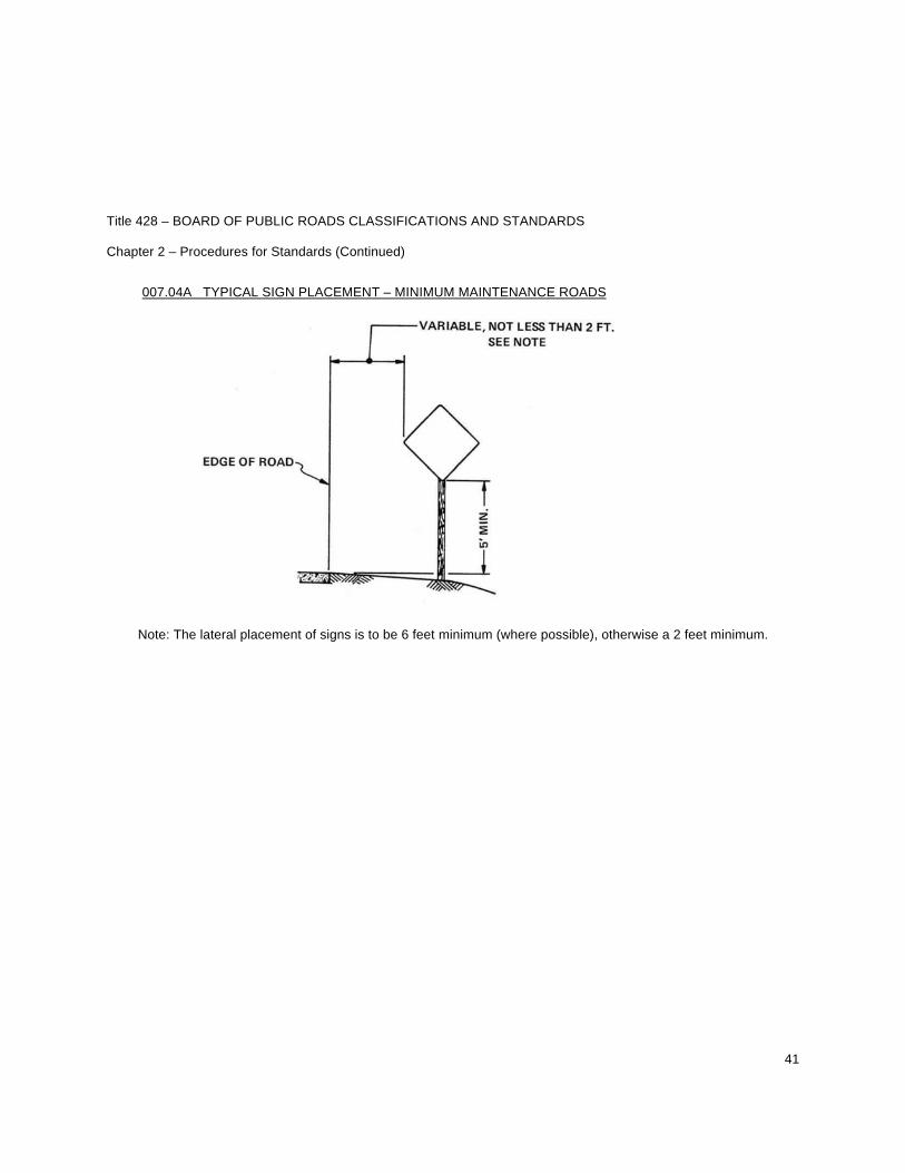
Title 428 – BOARD OF PUBLIC ROADS CLASSIFICATIONS AND STANDARDS Chapter 2 – Procedures for Standards (Continued)
41
007.04A TYPICAL SIGN PLACEMENT – MINIMUM MAINTENANCE ROADS
Note: The lateral placement of signs is to be 6 feet minimum (where possible), otherwise a 2 feet minimum.
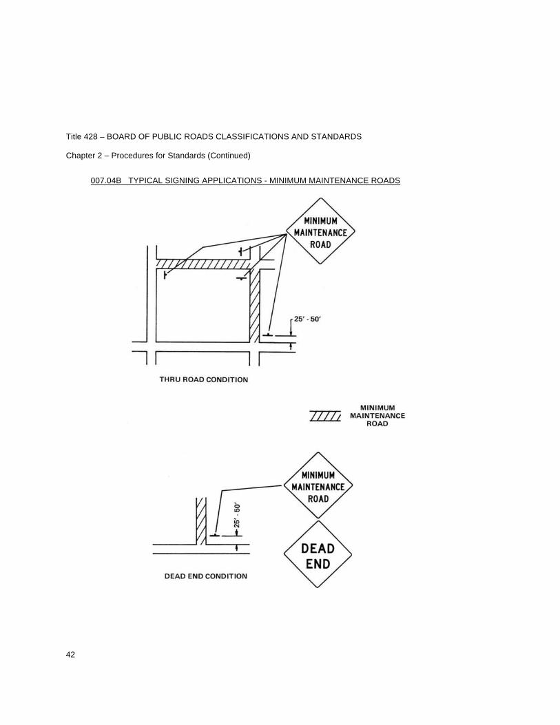
Title 428 – BOARD OF PUBLIC ROADS CLASSIFICATIONS AND STANDARDS Chapter 2 – Procedures for Standards (Continued)
42
007.04B TYPICAL SIGNING APPLICATIONS - MINIMUM MAINTENANCE ROADS
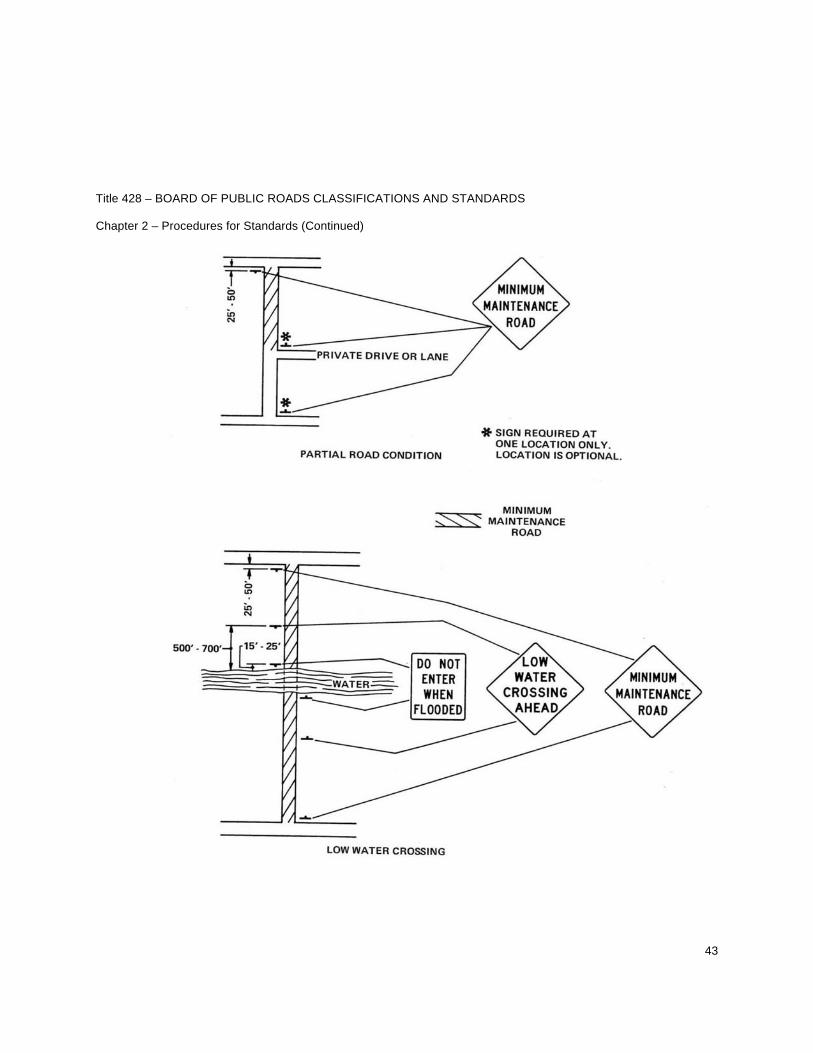
Title 428 – BOARD OF PUBLIC ROADS CLASSIFICATIONS AND STANDARDS Chapter 2 – Procedures for Standards (Continued)
43
Title 428 – BOARD OF PUBLIC ROADS CLASSIFICATIONS AND STANDARDS Chapter 2 – Procedures for Standards (Continued)
44
007.05 REQUIRED MAINTENANCE. The minimum maintenance roads shall be inspected at regular intervals by a qualified county or township official to see if an actual hazard exists and if discovered these shall be repaired. All signs shall be kept in good condition and replaced if necessary as signing is essential for the safe operation of these roads. These minimum maintenance roads shall not be deemed to be in want of repair or insufficient if it complies with these standards and level of minimum maintenance. 007.06 CONSTRUCTION STANDARDS. If it should be necessary to construct or reconstruct a segment of road classified as minimum maintenance, the county proposal shall be submitted to the Board of Public Roads Classifications and Standards for review prior to the start of construction in accordance with the rules and regulations for a relaxation of standards.
Title 428 – BOARD OF PUBLIC ROADS CLASSIFICATIONS AND STANDARDS Chapter 2 – Procedures for Standards (Continued)
45
008 STANDARD COMPLIANCE INSPECTION PROCEDURES
008.01 The Board of Public Roads Classifications and Standards may make random checks of construction projects in accordance with 39-2122 Neb. Rev. Stat. to determine that the minimum standards of design and construction are being met for any public highway, road or street. Inspection priorities are:
1. In response to a complaint received by the Board. 2. In response to a written request for inspection by a County Highway or a City Street
Superintendent. Such request will include a certification of approval of the request by the County Board of the requesting county or the City Council of the requesting municipality.
3. Projects selected for inspection by random methods.
008.02 The Board shall request necessary professional services from the Department of Roads for the Standard Compliance Inspection Program. 008.03 The Board shall schedule inspections not less than sixty days in advance. The secretary for the Board will notify the County Board or the City Council at least twenty days prior to the scheduled inspection. The notification letter will contain:
1. Project identification(s) of all projects within their jurisdiction to be inspected. 2. Invitation to the County Board or the City Council members and the County Highway or City Street
Superintendent to accompany the inspection party of the Board. 3. Name(s) of Board Representative(s). 4. A request that the County Board or the City Council furnish the name(s) of their inspection team
representative(s) if any, to the Board at least five days prior to the scheduled inspection.
008.04 A written standard compliance inspection report shall be prepared by the Department of Roads within three working days following the inspection. The inspection report shall contain:
1. A map showing the project identification and location. 2. The name and mailing address of each member of the inspection party. 3. Scope of the inspection. 4. A summary of findings and recommendations.
008.05 The Board shall review standards compliance inspection reports within sixty days. Upon acceptance of the report by the Board, the governing authority having project jurisdiction shall be notified of the summary of findings and recommendations if any.
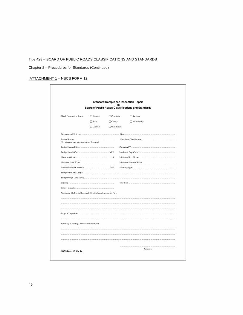
Title 428 – BOARD OF PUBLIC ROADS CLASSIFICATIONS AND STANDARDS Chapter 2 – Procedures for Standards (Continued)
46
ATTACHMENT 1 – NBCS FORM 12
Standard Compliance Inspection Report To
Board of Public Roads Classifications and Standards
Check Appropriate Boxes Request Complaint Random
State County Municipality
Contract Own Forces
Governmental Unit No. ........................................................................ Name .............................................................................................
Project Number ..................................................................................... Functional Classification ............................................................... (See attached map showing project location)
Design Standard No. .................................................................. Current ADT ...................................................................................
Design Speed (Min.) ..........................................................MPH Maximum Deg. Curve .....................................................................
Maximum Grade ..................................................................... % Minimum No. of Lanes....................................................................
Minimum Lane Width................................................................ Minimum Shoulder Width ...............................................................
Lateral Obstacle Clearance ..................................................Feet Surfacing Type.................................................................................
Bridge Width and Length................................................................................................................................................................................
Bridge Design Load (Min.) .............................................................................................................................................................................
Lighting...................................................................................... Year Built ........................................................................................
Date of Inspection ......................................................................
Names and Mailing Addresses of All Members of Inspection Party
.........................................................................................................................................................................................................................
.........................................................................................................................................................................................................................
.........................................................................................................................................................................................................................
Scope of Inspection.........................................................................................................................................................................................
.........................................................................................................................................................................................................................
Summary of Findings and Recommendations
.........................................................................................................................................................................................................................
.........................................................................................................................................................................................................................
.........................................................................................................................................................................................................................
......................................................................................................... Signature NBCS Form 12, Mar 74
1
Title 428 – BOARD OF PUBLIC ROADS CLASSIFICATIONS AND STANDARDS Chapter 5 – Hearing Practice and Procedure of the Board of Public Roads Classifications and Standards
001 HEARING PROCEDURE FOR THE PROMULGATION, AMENDMENT OR REPEAL OF THE RULES AND REGULATIONS OF THE BOARD OF PUBLIC ROADS CLASSIFICATIONS AND STANDARDS
001.01 An informal public hearing shall be held to consider promulgation, amendment or repeal of any Rule or Regulation of the Board unless waived by the Governor. 001.02 Notice as to time and place of the hearing shall be published in a newspaper of general circulation in the State at least twenty days in advance of the hearing. 001.03 Any party who desires a continuance shall, immediately upon receipt of notice of hearing, or as soon thereafter as facts requiring such continuance come to his/her knowledge, notify the Board’s Office in writing, by letter or telegram of said desire, stating in detail the reasons why such continuance is necessary. Any such party may be required to submit affidavits in support of such request. For good cause shown, the Board may grant a continuance, and may at any time order a continuance on the Board’s own motion. Only under exceptional circumstances will requests for continuance of a hearing by considered unless submitted on or before the seventh day prior to the date set for hearing. 001.04 The hearing shall be held at the Department of Roads Building, Central Complex, South Junction U.S. 77 and N-2, Lincoln, Nebraska, and/or at such other location as may be deemed advisable. 001.05 All hearings will be recorded and transcribed, in summary, for record. 001.06 A petition for the promulgation, amendment or repeal of any Board Rule or Regulation shall state the precise wording of the proposed Rule or addition, or the precise wording of the present Regulation to be deleted or repealed, shall state briefly the reasons for such promulgation, amendment or repeal and shall state the name and address of the petitioner. One original written request shall be required and shall be presented to the Board’s Secretary who shall furnish a copy to each Board Member and all known interested persons. The Board shall consider the petition within sixty days of receipt. The Board may, at any time, set a date for a hearing for the promulgation, amendment or repeal of any Rule or Regulation. 001.07 Failure of any petitioner to appear at the time and place set for hearing unless otherwise allowed by the Board on good cause shown, will be deemed sufficient grounds for the Board to dismiss the petition. 001.08 The chairperson of the hearing shall be a member of the Board and shall have the power to adjust the procedure of the hearing to meet special circumstances. 001.09 Those members of the Board and staff present shall be available to answer questions concerning the changes in the Rules and Regulations.
001.10 The chairperson will make an opening statement which shall fulfill all necessary legal requirements by setting out the purpose and giving recorded notice of the hearing. 001.11 The presiding officer shall have the power to recess the hearing at any time and to close it when all relevant discussion has been heard.
2
Title 428 – BOARD OF PUBLIC ROADS CLASSIFICATIONS AND STANDARDS Chapter 5 – Hearing Practice and Procedure of the Board of Public Roads Classifications and Standards (Continued)
001.12 Copies of the transcript shall be supplied to each Board Member in time to be reviewed before a decision is made. A copy of the transcript will be furnished without charge to any interested person upon request. 001.13 The findings shall consist of a concise statement of the conclusions upon each contested revision. Interested parties testifying at the hearing shall be notified of the decision and order in person or by mail. A copy of the decision and order and accompanying findings and conclusions shall be delivered or mailed upon request to each party or attorney of record. 001.14 The validity of the final order shall be subject to review in accordance with the laws of the State of Nebraska. 001.15 When any petition for the promulgation, amendment or repeal of any Rule or Regulation by the Board has been denied in whole or in part, a subsequent petition covering substantially the same subject matter will not be considered by the Board within one hundred eighty calendar days from the date of the final denial in whole or in part of the previous petition, except for good cause shown.
3
Title 428 – BOARD OF PUBLIC ROADS CLASSIFICATIONS AND STANDARDS Chapter 5 – Hearing Practice and Procedure of the Board of Public Roads Classifications and Standards 002 HEARING PRACTICE AND PROCEDURES BEFORE THE BOARD OF PUBLIC ROADS CLASSIFICATIONS AND STANDARDS
002.01 General
002.01A Scope and Application. These rules shall govern practice and procedure in all hearings involving contested cases as that term is defined in 84-901(3) Neb. Rev. Stat. Practice and procedure for hearings involving this Board is also governed by Chapter 84, Article 9 Neb. Rev. Stat. In the absence of a specific rule, practice pertaining to proceedings in the district courts of this State shall be applicable.
002.01B Filings. All correspondence and filings shall be address or delivered to the Board of Public Roads Classifications and Standards, State of Nebraska, Attention: Secretary for the Board, Box 94759, Lincoln, Nebraska 68509-4759.
002.01C Time Computation. In computing any period of time prescribed or allowed by these Rules the day of the act or event after which the designated period of time begins to run is not to be included. The last day of the period so computed is to be included, unless it is a Saturday, Sunday or a legal holiday, in which event, the period runs until the end of the next day which is neither a Saturday, Sunday nor a holiday. When the period of time prescribed or allowed is less than five days, intermediate Saturdays, Sundays and holidays shall be excluded in the computation. When the Federal government (Post Office) and the State observe the same holiday on different days and such prevents a party from acting within the prescribed time, both days observed shall be considered as holidays.
002.01D Copies of these rules shall be furnished without charge, to any interested person, upon request from the Board at its offices, South Junction U.S. 77 and N-2, Lincoln, Nebraska.
002.01E Appearances. Any individual may appear on his/her own behalf before the Board. An individual may appear on behalf of another if:
1. He/she is admitted to practice law before the Nebraska Supreme Court, or 2. He/she is admitted to practice law before the Supreme Court of any state and is accompanied
by a person admitted to practice before the Nebraska Supreme Court.
Nothing in this Rule shall prohibit attorneys representing the Board who are admitted to practice law in Nebraska from interrogating witnesses or otherwise participating in proceedings before the Board.
002.01F Definitions. As used in these Rules of practice and procedure, the following definitions shall apply unless the context, to be intelligible or prevent absurdity, otherwise requires:
002.01F1 Pleadings Defined: Pleadings shall mean any written application, petition, protest, complaint, answer or motion used in any proceedings pursuant to this Rule.
4
Title 428 – BOARD OF PUBLIC ROADS CLASSIFICATIONS AND STANDARDS Chapter 5 – Hearing Practice and Procedure of the Board of Public Roads Classifications and Standards (Continued)
002.01F2 Board Defined: Board shall mean the Board of Public Roads Classifications and Standards, State of Nebraska. 002.01F3 Filed with the Board Defined: The filing of pleadings with the Board as required by these Rules shall be made by filing them with the Secretary for the Board. If mailed to the Board the date of receipt at the Board and not the date of deposit in the mails is determinative. 002.01F4 Holiday Defined: A holiday is a day or any portion of a day designated by statute or authorized by the Governor in which no business is transacted by State Government. 002.01F5 Office Hours Defined: Office hours are 8:00 A.M. to 5:00 P.M., Monday through Friday. 002.01F6 Formal Public Hearing Defined: A formal public hearing may be a hearing conducted by a hearing examiner not within the employ of the Board at the time of appointment, the record of which hearing is prepared by a court reporter and at which the rules of evidence applicable in the district courts may be used if requested by either party in accordance with the requirement of 84-914 Neb. Rev. Stat. 002.01F7 Informal Public Hearing Defined: An informal public hearing shall be a hearing conducted by a hearing examiner who is a Board Member or a member of the Board’s staff, the record of which hearing shall be transcribed or recorded by the Board, at which either party may elect to be bound by the rules of evidence applicable in the district courts, if such election is in accordance with the requirements of 84-914 Neb. Rev. Stat. 002.01F8 Party Defined: Party shall mean the Nebraska Board of Public Roads Classifications and Standards, an individual, corporation or other entity that is aggrieved by a decision resulting from an interpretation and/or application of the Rules and Regulations of the Board of Public Roads Classifications and Standards.
002.02 Hearing Examiner.
002.02A Appointment of Hearing Examiner. Upon receipt of a request for a hearing by a party, the Board’s chairperson may appoint a Hearing Examiner to administrate, conduct and preside over a hearing, or may schedule the hearing before the Board at a regular or special meeting.
002.02A1 Informal Public Hearings. The Board’s chairperson may, in his/her discretion, appoint any individual to act as Hearing Examiner for informal hearings, including staff members within the employ of the Nebraska Department of Roads, so long as the individual so appointed can, in the opinion of the Board’s chairperson, serve as a Hearing Examiner in a competent and efficient manner. 002.02A2 Formal Public Hearings. The Board may appoint an individual to act as Hearing Examiner in formal public hearings who is not a member of the Board or a State employee.
5
Title 428 – BOARD OF PUBLIC ROADS CLASSIFICATIONS AND STANDARDS Chapter 5 – Hearing Practice and Procedure of the Board of Public Roads Classifications and Standards (Continued)
002.02B Duties of Hearing Examiner.
002.02B1 Conduct of Hearing. The Hearing Examiner shall preside at the hearing, open the proceedings, acknowledge appearance of parties and counsel, receive evidence for the record, rule on all motions and objections, may interrogate witnesses, and shall close the proceedings. If a party or parties are not represented by legal counsel, the Hearing Examiner shall explain to them the Rules of Practice and Procedure and shall conduct the hearing generally in a less formal manner.
002.02B2 Custodian of All Pleadings. Upon appointment as Hearing Examiner, the Hearing Examiner shall become the custodian of all pleadings, exhibits, depositions, documents, and briefs entered, filed and introduced into evidence by the parties.
002.02B3 Limitation of Powers. A Hearing Examiner, except for a Board Member, shall have no power to take any action involving a final determination of the proceedings.
002.02B4 Record of Proceedings.
002.02B4(a) Informal Public Hearing. The Hearing Examiner shall prepare an official record which shall include testimony and exhibits; however, it shall not be necessary to transcribe shorthand notes or recordings unless requested by either party.
002.02B4(b) Formal Public Hearing. The Hearing Examiner shall prepare an official record which shall include testimony and exhibits and such proceedings shall be recorded by a court reporter.
002.02B4(c) Notice of Hearing. It shall be the duty of the Hearing Examiner to determine that notice of hearing has been given in accordance with the Rules and Regulations of the Board. 002.02B4(d) Oath. All testimony presented before the Hearing Examiner shall be given under oath which the Hearing Examiner will have the authority to administer.
002.02B4(e) Conduct of Parties. The Hearing Examiner shall have the power to exclude or remove from the hearing any person who engages in improper conduct.
002.02B4(f) Findings and recommendations. The Hearing Examiner shall, in writing, make complete findings of fact and conclusions of law together with a recommendation for disposition of the issue to the Board.
002.03 Commencement of Proceeding. A hearing shall be scheduled within sixty days of receipt of a written request of a party. Such hearing may, at the discretion of the Board, be either a formal or an informal public hearing except that a formal public hearing shall be scheduled when so requested by a party.
6
Title 428 – BOARD OF PUBLIC ROADS CLASSIFICATIONS AND STANDARDS Chapter 5 – Hearing Practice and Procedure of the Board of Public Roads Classifications and Standards (Continued)
002.04 Scheduling of Hearing. A hearing shall be held no sooner than twenty days after receipt of a written request. 002.05 Location of Hearing. All hearings shall be held at the Lincoln offices of the Board at a room to be announced by the Hearing Examiner. 002.06 Notice of Hearing. The Board’s Secretary shall give reasonable notice of hearing stating the date, time, location and general subject matter of the hearing. Notice shall be given by mail no later than twenty days prior to a hearing. Failure of a party to appear at a hearing so scheduled shall be grounds for dismissal of the proceeding. 002.07 Motions.
002.07A Motions made prior to a hearing shall be in writing and a copy thereof shall be served on the parties. Such motions, except motions constituting final disposition of a proceeding, shall be ruled on by the Hearing Examiner. Motions constituting final disposition of a proceeding shall be ruled upon by the Board.
002.07B Motions may be ruled on exparte, without argument. A copy of the motion with the ruling thereon shall be mailed to the parties.
002.07C Motion for Continuance. Motions for continuance shall be granted at the discretion of the Hearing Examiner; however, no continuance shall be requested and none allowed but for good cause shown and in no case shall a hearing be continued for a period of more than twenty days.
002.08 Discovery.
002.08A The party shall have the right to request answers to questions, and to request the production of specified documents relevant to the proceedings. Further, each may take depositions of any witness upon ten working days notice to the other.
002.08B Discovery requests and/or notice shall be addressed to the party from whom the information or documents are sought with a copy filed with the Hearing Examiner.
002.08C Answers and documents must be provided within ten working days of receipt of request. Objections to such requests shall be made to the Hearing Examiner within five days of receipt of the request. The Hearing Examiner shall affirm or deny such objection within five days of receipt thereof and shall establish time limits for response when objections are denied.
002.08D Failure to respond to any discovery request, except where objections to such requests are sustained, may, at the discretion of the Hearing Examiner, result in the nonresponding party being denied the right to introduce any evidence on the subject of the request, or such other remedy as deemed appropriate.
7
Title 428 – BOARD OF PUBLIC ROADS CLASSIFICATIONS AND STANDARDS Chapter 5 – Hearing Practice and Procedure of the Board of Public Roads Classifications and Standards (Continued)
002.08E The time limits of the discovery procedure may, if necessary and justified in the opinion of the Hearing Examiner, be adjusted to accommodate the time required by the circumstances.
002.09 Subpoena. A subpoena may be had upon request which shall indicate to the Hearing Examiner the names and the last known addresses of the witnesses to be called. If evidence other than oral testimony is required, each item to be produced shall be adequately described. All requests for subpoena shall be directed to the attention of the Hearing Examiner no less than five days prior to the published date of said hearing. The Hearing Examiner shall issue subpoena as requested and mail the same to the party so requesting within seven days of receipt of request therefore. Service may be made either by mailing a copy thereof by registered or certified mail, return receipt requested, no less than three days before the hearing date of the cause which the witness is required to attend, or personally by any person not interested in the action. No costs for serving a subpoena will be allowed.
002.10 Conduct of Hearing. The Board shall present its case first, setting forth the grounds and reasons for its actions, and then the other party shall be heard. In cases, where the Board feels that the other party should be heard first, that party shall be notified not less than five days in advance of the hearing. 002.11 Decision of the Board. The decision of the Board shall be in writing and a copy of the decision shall be mailed to the party by mail no later than sixty days after the recommendation of the Hearing Examiner is received by the Board. The Board may, at its discretion, adopt the recommendation of the Hearing Examiner, or the Board may make an independent decision accompanied by its findings of fact and conclusions of law. Any decision concerning the penalty provisions of Nebraska Statutes shall be mailed by certified or registered mail.