1
ALKANE EXPLORATION LTD 242 250 254 257 260 356 300 312 323 335 289 264 267 271 282 276 521 m ASL 620 000 mE 616 000 mE 618 000 mE 612 000 mE 610 000 mE 614 000 mE 6400 000 mN 6402 000 mN 6404 000 mN 6396 000 mN 6398 000 mN 6386 000 mN 6388 000 mN 6390 000 mN 6392 000 mN 6394 000 mN Shuttle Radar Topography Mission 2nd edition (SRTM2) Digital Elevation Model (DEM) of the Tomingley regolith-landforms map area. This model features 90 m pixels and is sunshaded from the northeast to enhance topographic features. The SRTM2 DEM is courtesy of the United States National Aeronautics and Space Administration (NASA). Derivative map of the Tomingley regolith-landforms map depicting all regolith-landform units with in situ or transported materials interpreted to have the same bedrock parent. Polygons with the same modifier number (see main legend) have been selected and coloured to indicate those areas that should have similar background geochemical characteristics. Fill Mugincoble Chert Dulladerry Volcanics Obley Granite Cotton Formation Mumbidgle Formation Hervey Group Goonumbla Volcanics 620 000 mE 616 000 mE 618 000 mE 612 000 mE 610 000 mE 614 000 mE 6400 000 mN 6402 000 mN 6404 000 mN 6396 000 mN 6398 000 mN 6386 000 mN 6388 000 mN 6390 000 mN 6392 000 mN 6394 000 mN Intensified RGB airborne gamma-ray spectrometric image of the Tomingley regolith-landforms map area. Potassium (K), thorium (Th) and uranium (U) gamma-ray emissions are represented as the colours red, green and blue respectively. The image has been intensified by adding the Total Counts as an intensity layer using ER Mapper software to highlight strong and weak gamma-ray emitters as bright or dark areas as well as in situ and transported regolith types with differing proportions of K, Th and U. Original data courtesy of the NSW Department of Primary Industry from the Northern Parkes Geoscience data set. 620 000 mE 616 000 mE 618 000 mE 612 000 mE 610 000 mE 614 000 mE 6400 000 mN 6402 000 mN 6404 000 mN 6396 000 mN 6398 000 mN 6386 000 mN 6388 000 mN 6390 000 mN 6392 000 mN 6394 000 mN First vertical derivative (1VD) coloured and sunshaded aeromagnetic image of part of the Tomingley regolith-landforms map area from a high-resolution survey commissioned by Alkane Exploration Ltd. The image depicts broad roughly north-south striking structures related to bedrock geology and fractures that are overlain by short wavelength, high amplitude, curved and anastomosing near-surface features that have been interpreted as magnetic palaeochannels. Image courtesy of Alkane Exploration Ltd. 620 000 mE 616 000 mE 618 000 mE 612 000 mE 610 000 mE 614 000 mE 6400 000 mN 6402 000 mN 6404 000 mN 6396 000 mN 6398 000 mN 6386 000 mN 6388 000 mN 6390 000 mN 6392 000 mN 6394 000 mN 620 000 mE 616 000 mE 618 000 mE 612 000 mE 610 000 mE 614 000 mE 6400 000 mN 6402 000 mN 6404 000 mN 6396 000 mN 6398 000 mN 6386 000 mN 6388 000 mN 6390 000 mN 6392 000 mN 6394 000 mN Aerial orthophoto mosaic of the Tomingley regolith-landforms map area used in the mapping program. Aerial photographs include Run 1 #0159 and Run 2 #0174 from the Peak Hill 1:100,000 topographic sheet, acquired at 1:50,000 scale by the New South Wales Department of Lands, 10th May 2004. Orthorectifica- tion was performed at CRC LEME, ANU, using ER Mapper software with camera parameters supplied by the NSW Land Information Centre, the Space Shuttle Radar Topography Mission 2nd release (SRTM2) Digital Elevation Model and ground control points collected with a hand-held GPS receiver during field work. Aed6 SMer2 CHep2 Aed6 Fm Fm Fm Fm Apd6 Apd6 Apd6 Fm Fm Fm Fm Fm Aag1 Fm Fm Fm Aag1 Fm Apd1 Apd1 Aag1 Aag1 Aag1 CHep1 CHer1 CHep1 Aag1 Fm Fm CHer1 SMep1 CHep1 SMep1 SMep1 Fm Aag6 Aag6 CHer1 CHep1 Fm Aag1 Fm Fm Aed5 Fm Fm Apd1 Aed5 Fm Fm Fm Fm Fm Fm Fm Fm Apd5 Aed5 Aed5 Aed5 Fm Fm Aag1 Fm Aed1 Fm Aed1 Fm Aed1 Aag1 Aag1 Fm Aed1 Fm Fm Apd5 Apd5 Aag5 Fm Aed1 Apd6 Apd5 SMep4 CHep4 SMep4 Aed4 CHep4 SMer2 SMep4 SMep2 SMep2 SMep2 SMer2 SMep2 CHer2 CHep2 CHep2 Aaw5 Fm ACah7 Fm Apd7 Apd7 ACah5 Fm Fm SMer2 SMer2 Aed1 Fm Fm Aed5 Fm Fm Aed5 Aed5 CHep2 SMer2 CHep2 CHep2 CHep2 CHep2 Aed5 CHer5 CHer5 CHer5 Fm SMer4 SMep4 Af a5 CHer4 Aed4 Fm Fm Fm Fm CHer5 CHer5 CHep5 CHer5 CHep5 Fm CHep5 CHer5 CHer5 Apd7 Fm Fm Fm Fm Fm Aag5 AOap5 Apd7 Ap d7 Apd7 Aed5 Aed7 Apd7 Apd7 Fm Apd5 Apd5 ACah7 Fm Fm Fm Apd5 SMer2 Aed2 Fm SMer2 SMer2 SMer2 Fm Af a2 Aed2 Fm Fm SMer2 SMep2 Cer2 SMep2 SMep2 Cer2 CHpd2 CHpd2 Cer2 CHpd2 Aaw6 Fm CHpd2 Aed2 Fm AOap6 Aed6 Fm AOap6 Aed6 Fm Aed6 Fm Fm CHep6 Aed6 Aed6 CHep6 Fm SMep2 Aed5 Fm Cer2 Fm Fm CHer2 CHer5 CHer5 CHer5 AOap6 CHpd2 Fm Fm Fm Aed2 Aed2 CHpd2 Af a2 Aag2 Apd2 Aed6 Aag6 Fm Aag2 CHpd2 Cer2 CHpd2 CHpd2 Aed5 CHep5 CHep5 CHep5 CHep2 Aed2 Aag5 Fm ACah5 Fm Fm ACah5 Apd5 Apd2 Fm Fm Fm Aed5 Fm Fm Apd6 Aag1 Fm Fm Apd5 Aed1 Fm Fm Aag7 Aed7 Fm Aed1 Fm Aed1 Aed1 Fm Fm Aed1 Aed5 Aed1 SMep3 Apd5 CHpd4 CHer4 Fm CHpd4 Fm Apd4 Apd4 Apd4 Aed4 Aag4 Apd4 Aag2 CHer2 Apd5 Apd5 Apd5 Apd5 Apd5 Apd5 Apd5 Apd5 Apd5 Apd5 Apd5 Apd5 Apd5 Apd5 Fm Fm Fm Apd5 Fm Fm Aaw5 Fm Apd4 Aed5 Aed5 Apd5 Fm Fm Apd6 AOap6 Fm Apd6 Aed6 Apd6 Aed6 Aap6 Aap6 Fm Fm Apd6 Aap6 Apd6 Aed6 Apd6 Fm Aed6 Apd6 Apd6 AOap6 AOap6 AOap6 Aed6 Aap6 Apd6 AOap6 Aaw6 Aed6 Apd6 Apd6 Apd6 Apd6 Apd6 Apd6 Aag6 Aed1 Fm Aag1 Fm Fm Apd1 Fm Aed1 Aed1 Fm Fm Aed1 Apd5 Apd5 Fm Fm ACah5 Fm Aed1 Aed1 Fm Fm Aap1 Fm Aed1 Fm Fm Fm Aed5 Apd5 Aag6a Aag6 Fm Aag6 AOap6 Apd6 Aag6 Apd6 Aag6 Apd6 Apd6 Fm Fm Fm Apd6 Fm Fm Fm Apd6 Fm Aed6 Apd6 Aag6 Fm Fm ACah6 ACah6 Aed6 ACah6 Aaw6 Aed6 Aag6 Aed6 Aed6 Aaw6 Apd6 Aed6 AOap6 AOap6 Aag6 Aag6 Aed6 Fm Fm Aed5 Aag6 Aag6 Aed6 Apd6 Apd6 Apd6 Aed6 Apd6 Fm Aag6a Aag6 Fm AOap6 Apd6 Fm Aag6 Fm Aag6a Aag6 Aaw6 Aed6 Fm Apd6 Fm Apd6 Fm Fm Aag6 AOap5 AOap5 Apd7 Apd5 Apd5 Apd5 Apd5 Apd5 Apd5 Apd5 Apd5 Apd5 Apd5 Apd5 Apd5 Apd5 Apd5 Apd5 AOap5 AOap5 AOap5 Aed5 Apd5 AOap5 Apd5 AOap5 ACah5 Fm Aed2 Aed2 Aed4 Aed4 Aed4 Aed4 Fm Fm ACah5 Fm Fm Apd5 Apd5 ACah6 Apd6 Aed6 Fm Fm AOap6 AOap6 AOap6 Aed6 Aag5 Apd5 Aed6 Fm Aed5 Fm CHep4 Apd4 Apd7 Apd5 Apd5 Apd1 Apd5 SMep3 Aag6 Fm ACah6 Fm Apd6 Aag6 Fm AOap6 Fm Fm Fm Fm Fm Fm Aag6 Fm Fm Cer1 AOap6 Fm AOap6 Fm Fm Fm Fm Fm Fm Fm Fm Fm Fm Fm Aed6 Fm Apd2 Fm Fm Fm Fm Fm Fm Fm Aed6 Aed6 Fm Fm Fm Apd5 AOap6 Aed6 Fm Fm Fm Aed6 Apd6 Apd6 Apd6 Fm Fm Apd6 Apd6 Fm Apd6 Fm Fm Fm Fm Apd6 Aed7 Aag7 Apd7 Fm Apd6 Fm AOap6 Apd6 Fm Fm Fm Fm ACah6 Aed6 Apd6 Apd6 Aed6 Fm Fm Apd7 Fm Fm Fm ACah6 AOap6 Apd6 Apd7 Apd7 Apd6 Apd6 AOap6 Apd6 Aaw6 Aaw6 Apd6 Apd6 Aaw6 Apd6 Apd6 Fm Fm Fm Apd6 ACah6 Fm ACah6 Aed6 Aed6 Fm Fm Fm Apd6 Aed6 ACah6 Fm ACah6 Aed6 Apd6 Apd6 Aag6 Fm Fm Fm Apd6 Fm Apd6 Apd6 Apd6 Apd6 Apd6 Apd6 Apd6 Apd6 AOap6 Fm AOap6 Aed6 Fm AOap6 AOap6 AOap6 AOap6 Apd6 AOap6 Fm AOap6 Apd6 AOap6 ACah6 Aed6 Fm Fm Aed6 Fm Fm AOap6 ACah6 AOap6 Fm Fm Fm Fm Fm Apd6 Aed6 Apd6 Fm Apd6 Aed6 Fm Fm Fm AOap6 Fm Fm AOap6 AOap6 Aed6 Fm Fm Fm Aed6 Fm Fm Aed6 Aed6 Fm ACah6 Fm ACah6 AOap6 AOap6 Aed6 Aed2 Fm Apd2 Aed6 Apd6 Apd6 Fm Aed6 Apd6 Aed6 Aed6 Fm Aed6 Fm Apd2 Aed2 Apd2 Fm SMep1 Aed1 Fm Apd4 Fm Aed4 Aag5 Apd5 SMep1 Apd6 Apd1 Fm Fm Fm Fm Fm SMep1 Fm Apd5 Fm Fm Af a5 Apd4 Af a5 Apd2 Af a5 Apd2 Aed5 Aed5 Fm Fm Fm Fm Apd2 Fm Fm Apd2 Apd1 Apd1 Apd5 Fm Aed4 Fm Aed4 Fm Aed4 Apd4 Cer2 Aed2 Aed2 Aed2 Fm Fm Fm Apd2 Aed2 Aed2 Fm Apd2 Apd2 Aed2 Aed2 SSel6 SSel6 SSer6 Aed6 CHel6 CHel6 CHel6 Fm CHer6 CHer6 Fm Fm Fm Fm Aed6 Fm Fm Fm Aed1 Aed6 Aed6 CHel6 Fm Fm Fm Aed6 Fm Aed6 Fm Aed6 CHep6 CHep6 Aed6 Fm Fm CHer6 CHer6 CHer6 CHer1 SMep1 Apd6 Apd1 Fm Apd6 Apd1 Aed6 Aed2 Apd6 Apd1 Apd1 Apd1 Fm Apd1 Aed6 Apd6 Apd6 Apd6 Apd6 Fm Apd6 Apd6 Apd6 Apd6 Apd6 Fm Apd6 Apd6 Apd6 Fm Fm Fm Fm Fm Apd6 CHel6 SMep6 CHel6 Apd2 Aed2 Fm Aed2 Apd6 Apd6 Apd6 Fm Aaw6 Fm Aed6 Fm Fm ACah6 AOap6 Fm Fm Fm Apd6 Apd6 Fm Aed6 AOap6 Aed6 AOap6 Fm Aed6 AOap6 Fm Apd6 Fm Aaw6 Aed6 Aed6 Aed6 AOap6 AOap6 AOap6 Fm ACah6 Fm Fm Fm ACah6 Fm ACah6 Apd6 AOap6 Apd6 Aed6 Fm Fm Fm Aed6 Fm Aed6 Apd6 Fm Fm Fm Fm Aed6 Aed6 Aed6 Aed6 Fm Fm Fm Apd6 Fm Apd6 Apd6 Apd6 Fm Apd6 Apd6 Fm AOap6 AOap6 Fm Fm Aed6 Fm Fm Apd6 Aed6 Apd6 Fm Aed6 Aed6 AOap6 Fm Aed6 Aed6 Apd6 AOap6 ACah6 Aed6 AOap6 Aed6 Apd6 Fm Fm Aed6 Aed6 Aed6 Fm AOap6 AOap6 Apd6 Aed6 Apd6 Aed6 Apd6 Aed6 Apd6 Apd6 Apd6 Apd6 Apd6 AOap6 AOap6 Aed6 AOap6 Apd6 AOap6 Fm Fm Fm Aed6 Aag6 Fm Aag6 Apd6 AOap6 Apd6 AOap6 Aed6 AOap6 Fm Aed6 AOap6 Apd6 Fm Apd6 Fm Fm Fm Fm Fm Fm AOap6 Fm Apd6 AOap6 Fm Fm ACah6 AOap6 Fm Apd6 AOap6 Apd6 Fm Aed6 Aed6 Fm Fm Fm Apd6 Apd6 Apd6 Apd6 Apd6 Fm Apd6 Apd6 Apd6 Apd6 Aed6 Apd6 Apd6 Fm Aaw6 Fm Apd6 Fm Fm Fm Fm Apd6 Apd6 Fm Aed2 Fm Fm Apd6 Apd6 Apd6 AOap6 Fm CHel6 CHel1 CHel1 Apd6 Apd6 Apd6 Aaw6 Aed6 Aed6 Aed6 AOap6 Apd6 Aed6 AOap6 Apd6 AOap6 Aed6 Aed6 AOap6 Apd6 Apd6 Apd6 AOap6 Aed6 Aed6 Fm Fm AOap6 Aag6 Aag2 Aed2 Aed6 Aed6 Apd6 CHep4 CHep2 CHep2 CHep6 Aed2 Aed2 Aag5 Aed2 Aed2 Aed5 Apd4 Apd5 Aed4 Aed2 Aed2 Aed4 Aed4 ACah5 ACah7 Apd7 Apd5 Apd7 Apd5 Apd5 Apd7 Apd7 Aag6a Aag6 Apd6 Apd6 Apd6 Aag6 Aed5 Apd6 Apd2 Apd6 Af a5 Aed6 Aed5 Aed2 Apd5 AOap5 Aag5 Aag2 Aed6 Af a5 Apd6 Apd6 Apd5 Fm Apd6 Aed6 Aed6 Apd5 Af a5 Apd6 Aed6 AOap6 AOap6 Apd6 Crow hurst McLeans Prospect Wyoming 3 Myalls United Smiths Patons Wyoming 2 Centenary Tomingley 2 Tomingley 1 Wyoming 1 Fm Fm Fm Apd5 SMer4 References Pain C., Chan R., Craig M., Gibson D., Ursem P. & Wilford J. 2000. RTMAP regolith database field book and users guide. CRC LEME Report No. 138, 97 p. Roach I.C. 2007. Tomingley 1:25,000 regolith-landforms map, central western New South Wales. CRC LEME Open File Report 233, 24 p. + map. Sherwin L. 1996. Explanatory notes Narromine geological sheet 1:250,000 SI/55-3, second edition. Geological Survey of New South Wales, Sydney, 104 p. MinView. Geological Survey of New South Wales, New South Wales Department of Primary Industries, MinView digital tenement search system. Available at http://minview.minerals.nsw.gov.au/. Other references associated with this map Bamford P.L.M., McQueen K.G. & Scott K.M. 2004. Geochemical dispersion and under-cover expression of gold mineralisation at the Wyoming gold deposit, Tomingley, NSW. In: Roach I.C. ed. Regolith 2004. CRC LEME, pp. 26-28. Chalmers I, Ransted T and Kairaitis R 2003. The Tomingley gold project and the discovery of the Wyoming gold deposits, New South Wales. In: NewGenGold 2003. Louthean Media Pty Ltd, Perth, WA, pp. 171-184. Roach I.C. 2004. Results of a preliminary biogeochemical survey of the Wyoming Au deposit, Tomingley, NSW. In: Roach I.C. ed. 2004. Regolith 2004. CRC LEME, pp. 306-309. Roach I.C. & Walker S.D. 2005. Biogeochemical expression of gold in native tree leaves at Wyoming and Tomingley, NSW. In: Roach I.C. ed. Regolith 2005 – Ten Years of CRC LEME. CRC LEME, pp. 277-282. Roach I.C. 2006. Tomingley project, central western NSW, 1: regolith-landform mapping techniques and implications for landscape evolution. In: Fitzpatrick R.W. & Shand P. eds. Regolith 2006 - Consolidation and Dispersion of Ideas. CRC LEME, pp. 296-300. Roach I.C. 2006. Tomingley project, central western NSW, 2 : regolith-landforms of the Tomingley area. In: Fitzpatrick R.W. & Shand P. eds. Regolith 2006 - Consolidation and Dispersion of Ideas. CRC LEME, pp. 301-303. Scott K.M., Chalmers D.I., Ransted T. & Kairaitis R. 2005. Wyoming gold deposit, central western NSW. In: Butt C.R.M., Cornelius M., Scott K.M. & Robertson I.D.M. comps. & eds. Regolith expression of Australian ore systems. CRC LEME, pp. 348-350. TOMINGLEY REGOLITH-LANDFORMS INCORPORATING THE WYOMING GOLD DEPOSIT SCALE 1:25,000 TRANSPORTED REGOLITH Alluvial sediments Colluvial sediments Fill Fm Principally bulldozed or graded regolith in and surrounding farm dams. Also includes mullock dumps composed of unweathered bedrock and saprolith of Goonumbla Volcanics at the Myalls United mine site. IN SITU REGOLITH Saprolite SMep (1) Moderately weathered and slightly to moderately ferruginised outcrop with a discontinuous cover of angular to subangular sand to pebbles of quartz and weakly ferruginised sandstone and siltstone with red-brown fine sand and silt and minor subrounded maghemite granules filling opening joints and bedding planes in round-topped plains slightly elevated above surrounding alluvial plains; or, (2) slightly to moderately ferruginised saprolite consisting of outcrop and angular to subangular sand to pebbles of quartz and weakly ferruginised chert with red-brown fine sand and silt and minor subrounded maghemite granules filling opening joints and bedding planes in undulating plains flanked by colluvial plains and rises; or, (3) slightly to moderately ferruginised saprolite consisting of outcrop and angular to subangular sand to pebbles of quartz and weakly ferruginised chert with red-brown fine sand and silt and minor subrounded maghemite granules filling opening joints and bedding planes in undulating plains flanked by colluvial plains and rises; or, (4) Slightly to moderately ferruginised saprolite consisting of outcrop and angular to subangular sand to pebbles of quartz and weakly ferruginised chert with red-brown fine sand and silt and minor subrounded maghemite granules filling opening joints and bedding planes in undulating plains flanked by colluvial plains and rises; or, (6) Weakly ferruginised granite saprolite outcrop consisting of grey clay and angular quartz and lithic coarse sand to pebbles with minor red-brown fine sand and silt. Colonised by forbs and grasses with: (1) Eucalyptus viridis in the west and Eucalyptus microcarpa, Allocasuarina luehmannii, Callitris glaucophylla, Geijera parviflora and Acacia sp. in the east; or, (2) Eucalyptus microcarpa, Eucalyptus sideroxylon, Callitris glaucophylla, Acacia sp., Geijera parviflora and shrubs; or, (3) Eucalyptus microcarpa, Callitris glaucophylla, Allocasuarina luehmannii, Acacia sp. and Geijera parviflora; or, (4) Eucalyptus microcarpa, Eucalyptus sideroxylon, Callitris glaucophylla, Geijera parviflora and Acacia sp.; or, (6) minor Eucalyptus microcarpa and Callitris glaucophylla. SMer (2) Moderately weathered and slightly to moderately ferruginised saprolite outcrop and angular to subangular coarse sand to pebbles of quartz and weakly ferruginised chert with red-brown fine sand and silt and minor subrounded maghemite granules filling opening joints and bedding planes in rises flanked by colluvial plains and rises; or, (4) Slightly to moderately ferruginised saprolite outcrop and angular to subangular pebbles to cobbles of quartz and weakly ferruginised mudstone, siltstone and sandstone with opening bedding planes and joints filled with red-brown fine sand and silt and minor subrounded maghemite granules in undulating plains. Colonised by: (2) Eucalyptus microcarpa, Eucalyptus sideroxylon, Callitris glaucophylla, Acacia sp., Geijera parviflora, shrubs, forbs and grasses; or, (4) forbs and grasses. SSel Slightly weathered and ferruginised granite outcrop consisting of tors and pavements with a discontinuous cover of grey clay, angular quartz and granite lithic coarse sand to boulders in a low hill of rugged well-forested landscape. Colonised by Eucalyptus microcarpa, Eucalyptus populnea, Callitris glaucophylla, Geijera parviflora, Acacia sp., shrubs, forbs and grasses. SSer Slightly weathered and ferruginised granite outcrop consisting of tors and pavements with a discontinuous cover of minor grey clay, angular quartz and granite lithic coarse sand to boulders in a rise of rugged well-forested landscape. Colonised by Eucalyptus microcarpa, Eucalyptus populnea, Callitris glaucophylla, Geijera parviflora, Acacia sp., shrubs, forbs and grasses. Saprock RLU key descriptions for the Tomingley regolith-landforms map The alphanumeric regolith-landform unit (RLU) polygon codes provide a framework to present regolith materials, landforms and associated vegetation on the map sheet. RLU codes are designed to first list the broad regolith lithology in capital letter codes, then landforms in lower case codes. The modifier number following each alphabetic RLU code allows for discrimination of variations of the broader regolith-landform assemblages, in this case due to differing bedrock lithology based on the Narromine 1:250,000 geological map sheet of Sherwin (1996). The RLU codes are based largely on the interpretation of the dominant regolith-landform process responsible for their formation (i.e., genetic process) and follow the RTMAP scheme of Pain et al. (2000). Lithological and other RLU attributes are described in the attached legend and accompanying map report. RLU codes for regolith materials depicted here are: RLU codes for landforms used here are: A Alluvial sediments ag alluvial gilgai depressions AC Alluvial channel sediments ah alluvial channel AO Alluvial overbank sediments ap alluvial plain (with numerous small drainage depressions) C Colluvial sediments aw alluvial swamp CH Colluvial sheetflow sediments ed erosional drainage depression F Fill ep erosional plain (0-9 m relief) SM Moderately weathered bedrock (saprolite) er erosional rise (9-30 m relief) SS Slightly weathered bedrock (saprock) el erosional low hill (30-90 m relief) fa alluvial fan m man-made pd depositional plain (with no significant drainage depressions) RLU modifier codes used here reflect bedrock lithologies of Sherwin (1996) or regolith material sources are: 1 Cotton Formation (O-Sc) sandstones and siltstones 2 Mugincoble Chert (Om) 3 Goonumbla Volcanics (Obv) mafic lava and flow breccia 4 Mumbidgle Formation (Sfm, Sfv) mudstone, siltstone and minor sandstone 5 Dulladerry Volcanics (Dds, Ddr, Ddc) rhyolite and quartz porphyry 6 Obley Granite (Dog) 7 Hervey Group (Dh) quartz sandstones 0 1 2 km Grid North Tomingley 1:25,000 regolith-landforms map. Australian Map Grid coordi- nates using the Australian Geodetic Datum of 1966 (AGD66), Universal Transverse Mercator projection Zone 55S (UTM 55S). Tomingley 1:25,000 regolith-landforms map Compiled by and cartography by Ian C. Roach (MTEC Lecturer in Regolith Geoscience, CRC LEME/Australian National University). It is recommended that this map be referred to as: Roach I.C. 2006. Tomingley 1:25,000 regolith-landforms map. Cooperative Research Centre for Landscape Environments and Mineral Exploration (CRC LEME), Perth. The regolith-landform polygons on this map are based on an interpretation of 1:50,000 scale aerial photographs, airborne geophysical imagery (principally gamma-ray spectrometrics) and extensive field mapping. It is the intention of this map to identify and characterise surface materials and landforms in a prospective area with limited exposed bedrock. © This map is Copyright of the Cooperative Research Centre for Landscape Environments and Mineral Exploration, 2007, which resides with its Core Participants: CSIRO Exploration and Mining and Land and Water, The Australian National University, Curtin University of Technology, The University of Adelaide, Geoscience Australia, Primary Industry and Resources SA, NSW Department of Primary Industries and Minerals Council of Australia. Apart from any fair dealing for the purposes of private study, research, criticism or review, as permitted under Copyright Act, no part may be reproduced or reused by any process whatsoever, without prior written approval from the Core Participants mentioned above. Inquiries should be directed to: The Business Manager CRC LEME c/o CSIRO Division of Exploration and Mining PO Box 1130 Bentley WA 6102 Disclaimer The user accepts all risks and responsibility for losses, damages, costs and other consequences resulting directly or indirectly from using any information or material contained in this map. To the maximum permitted by law, CRC LEME excludes all liability to any person arising directly or indirectly from using any information or material contained in this report. Most information is digitised from 1:50,000 scale aerial photographs or is taken directly from digital track logs of hand-held GPS devices. A small proportion of information is taken from the New South Wales Department of Primary Industry’s Northern Parkes Geophysical Dataset. CRC LEME acknowledges the support of Alkane Exploration Ltd. in the production of this map. CRC LEME is an unincorporated joint venture between the Australian National University, The University of Adelaide, The Curtin University of Technology, CSIRO Exploration and Mining, CSIRO Land and Water, Primary Industries and Resources South Australia, The New South Wales Department of Primary Industry and the Minerals Council of Australia, established and supported under the Australian Government’s Cooperative Research Centres Program. Copies of this map may be obtained from: CRC LEME c/o CSIRO Division of Exploration and Mining PO Box 1130 Bentley WA 6102 http://crcleme.org.au/. FIRST EDITION Subject to revision 6404000 mN 6403000 mN 6402000 mN 6399000 mN 6395000 mN 6396000 mN 6397000 mN 6398000 mN 6400000 mN 6392000 mN 6393000 mN 6394000 mN 6401000 mN 6391000 mN 6386000 mN 6387000 mN 6388000 mN 6389000 mN 6390000 mN 619000 mE 620000 mE 614000 mE 615000 mE 616000 mE 617000 mE 618000 mE 613000 mE 609000 mE 610000 mE 611000 mE 612000 mE TOMINGLEY WYOMING Newell Highway Newell Highway Newell Highway Aag Plains with poorly to well developed gilgai with depressions up to 10 m diameter and 1 m deep. Depressions contain dark organic-rich clays in small swamps. The surrounding plains dominantly contain: (1) red-brown fine sand and silt with subangular coarse sand to small pebbles of quartz; or, (2) light to dark grey subangular to subrounded quartzose coarse sand and granules and weakly ferruginised fine sandstone and shale lithic fragments and minor subrounded maghemite granules; or, (4) subrounded to subangular pebbles of vein quartz and weakly ferruginised chert lithic fragments; or, (5) rhyolite porphyry lithic fragments; or, (6, 6a, 7) dominantly subangular to subrounded granules to small pebbles of weathered granite lithics with minor red-brown fine sand and silt and minor subrounded maghemite granules. Colonised by sedges and other water-tolerant grasses and forbs in the depressions and surrounded by an open woodland of Eucalyptus microcarpa, Allocasuarina verticillata, Alectryon oleifolius, Geijera parviflora, Eremophila sp., Acacia sp., rare Pittosporum philliraeoides, rare Apophyllum anomalum, grasses, forbs and exotic weeds, major species varying depending on location, water availability and substrate. Aap A low relief plain with anastomosing drainage depressions with: (1) subangular to subrounded quartz, weakly ferruginised weathered siltstone and fine sandstone lithic sand and granules and red-brown fine sand and silt with minor subrounded maghemite granules; or, (2) light grey coloured subangular to subrounded quartz and weathered granite lithic coarse sand and granules with rare lithic pebbles and grey clays and minor red-brown fine sand and silt with minor subrounded maghemite granules. Colonised principally by: (1) forbs and grasses and scattered Eucalyptus microcarpa, Callitris glaucophylla, Allocasuarina luehmannii and Geijera parviflora; or, (2) Eucalyptus populnea with Eucalyptus microcarpa, forbs and grasses. Aaw Water-saturated low-lying swampy tracts of alluvial systems with dark grey to black organic-rich clay and silt with subangular to subrounded quartz sand and granules and: (5) rhyolite porphyry lithic sand and granules; or, (6) weathered granite lithic sand and granules. Colonised by sedges and other water-tolerant forbs and grasses. ACah Stream channels < 10 m wide and < 3 m deep with stream bank deposits of grey clay and lithic gravel and channel deposits of minor red-brown fine sand and silt with: (5) subrounded to rounded silt to cobbles of quartz and weathered rhyolite porphyry, chert, mudstone, siltstone and sandstone lithics; or, (6) subrounded to rounded silt to cobbles of quartz and weathered granite lithics; or, (7) subrounded to rounded silt to cobbles of quartz and weakly ferruginised sandstone lithics. Colonised principally by: (5, 7) Eucalyptus camaldulensis with minor Acacia sp., Eremophila sp., forbs and grasses; or, (6) Eucalyptus camaldulensis with minor Eucalyptus populnea, Eucalyptus microcarpa, Acacia sp., forbs and grasses, depending on location. Aed Dark red to brown organic-rich materials in broad shallow alluvial tracts with clay and quartz silt and minor subrounded maghemite granules with: (1) minor subangular to subrounded quartz and weakly ferruginised siltstone and sandstone lithic sand and granules; or, (2) minor subangular to subrounded quartz and chert lithic sand and granules; or, (4) minor subangular to subrounded quart and weakly ferruginised mudstone, siltstone and sandstone lithic sand and granules; or, (5) minor subangular to subrounded quartz and possibly weathered rhyolite porphyry lithic sand and granules; or, (6) minor subangular to subrounded quartz and weathered granite lithic sand and granules; or, (7) minor subangular to subrounded quartz and sandstone lithic sand and granules. Colonised principally by forbs and grasses with Eucalyptus microcarpa, Eucalyptus populnea, Eucalyptus sideroxylon, Acacia sp. and Eremophila sp. depending on location. Cer Red-brown fine sand and silt and minor subrounded maghemite granules on rises flanking saprolith ridges with: (1) angular coarse sand to cobbles of quartz and weakly ferruginised siltstone and sandstone lithics over minor outcrop of the same with joints opening on an undulating rise; or, (2) Angular coarse sand to pebbles of quartz and weakly ferruginised chert lithics. Colonised by forbs and grasses with: (1) Eucalyptus microcarpa, Eucalyptus populnea, Allocasuarina luehmannii, Callitris glaucophylla, Acacia sp., Geijera parviflora and minor Pittospo- rum philliraeoides; or, (2) Eucalyptus microcarpa, Callitris glaucophylla, Acacia sp. and Geijera parviflora. CHel Low hills flanking granite saprolith ridges with: (1) angular to subangular coarse sand to pebbles of quartz and weakly ferruginised sandstone and siltstone lithics mixed with grey coloured angular to subangular coarse sand to pebbles of quartz and weathered granite lithics and minor red-brown fine sand and silt and grey clay; or, (6) angular to subangular sand and granules of quartz and weathered granite with grey clay and minor red-brown fine sand and silt. Colonised principally by forbs and grasses with: (1) sparse Eucalyptus microcarpa, or (6) Eucalyptus microcarpa, Eucalyptus populnea, Allocasuarina luehmannii, Callitris glaucophylla, Acacia sp. and other shrubs. CHep Low relief, round-topped undulating plains slightly elevated above surrounding alluvial plains or flanking saprolith plains with angular to subangular coarse sand to pebbles of quartz and: (1) weakly ferruginised sandstone and siltstone; or, (2) weakly ferruginised chert lithics; or, (4) weakly ferruginised mudstone, siltstone and sandstone lithics; or, (5) weathered rhyolite porphyry lithics, all with red-brown fine sand and silt and minor subrounded maghemite granules; or, (6) angular to subangular coarse sand to pebbles of quartz and weathered granite lithics with grey clay and minor red-brown fine sand and silt. Colonised by: (5) forbs and grasses with: (1) minor Eucalyptus microcarpa, Eucalyptus viridis, Callitris glaucophylla, Allocasuarina luehmannii and Geijera parviflora; or, (2) Eucalyptus microcarpa, Eucalyptus sideroxylon, Callitris glaucophylla, Acacia sp., Geijera parviflora, shrubs and minor Eucalyptus populnea; or, (4) Eucalyptus microcarpa, Eucalyptus sideroxylon, Callitris glaucophylla, Acacia sp., Geijera parviflora and shrubs; or, (6) Eucalyptus microcarpa. CHer Rises flanking saprolith low hills or round-topped rises elevated above surrounding alluvial plains or flanking saprolith plains. Angular to subangular coarse sand to pebbles of quartz and red-brown fine sand and silt and minor subrounded maghemite granules with: (1) weakly ferruginised sandstone and siltstone with red-brown fine sand; or, (2) weakly ferruginised chert lithics: or, (4) weakly ferruginised mudstone, siltstone and sandstone lithics; or, (5) weathered rhyolite porphyry lithics; or, (6) angular to subangular sand and granules of quartz and weathered granite with grey clay and minor red-brown fine sand and silt. Colonised by forbs and grasses with: (1) minor Eucalyptus microcarpa, Eucalyptus viridis, Callitris glaucophylla and Allocasuarina luehmannii; or, (2, 4) minor Eucalyptus microcarpa, Eucalyptus sideroxylon, Callitris glaucophylla, Geijera parviflora and Acacia sp.; or, (5) minor Eucalyptus microcarpa, Eucalyptus sideroxylon and Acacia sp.; or, (6) Eucalyptus microcarpa, Eucalyptus populnea, Allocasuarina luehmannii, Callitris glaucophylla, Acacia sp. and Geijera parviflora. CHpd Low relief undulating plains flanking colluvial and saprolith plains and rises. Subangular to subrounded coarse sand to pebbles of quartz with: (2) weakly ferruginised chert lithics; or, (4) weakly ferruginised mudstone, siltstone and sandstone lithics, with red-brown fine sand and silt and minor subrounded maghemite granules. Colonised by forbs and grasses with: (2) minor Eucalyptus microcarpa, Eucalyptus sideroxylon, Callitris glaucophylla and Acacia sp.; or, (4) with Eucalyptus microcarpa and Eucalyptus sideroxylon, Afa Red-brown fine sand and silt with minor angular to subangular coarse sand to pebbles of quartz in low-relief plains with: (2) weakly ferruginised chert and minor subrounded maghemite granules; or, (5) possibly weathered rhyolite porphyry granules and pebbles on a low relief plain. Colonised principally by forbs and grasses with rare Eucalyptus microcarpa, Allocasuarina luehmannii, Callitris glaucophylla and Acacia sp. AOap Light red coloured subangular to subrounded quartz silt and sand on low-relief plains with numerous anastomosing drainage depressions with: (5) possibly weathered rhyolite porphyry lithic sand and granules with red-brown fine sand and silt and minor subrounded maghemite granules; or, (6) light grey coloured subangular to subrounded quartz and weathered granite lithic coarse sand and granules with rare pebbles and grey clay and minor red-brown fine sand and silt and minor subrounded maghemite granules, Colonised by forbs and grasses with: (5) Eucalyptus microcarpa, Callitris glaucophylla, Allocasuarina luehmannii, Geijera parviflora, rare Eucalyptus sideroxylon, Acacia sp., Eremophila sp., forbs and grasses; or, (6) Eucalyptus populnea with Eucalyptus microcarpa, rare Eucalyptus melliodora, Callitris glaucophylla, Allocasuarina luehmannii, Geijera parviflora, Eremophila mitchellii, Senna artemisioides ssp. Zygophylla and Dodonea cuneata. Apd Red-brown fine sand and silt with minor angular to subangular sand to pebbles of quartz and minor subrounded maghemite granules on broad plains with extremely subdued relief with coarse sand to pebbles of: (1) weakly ferruginised sandstone and siltstone; or, (2) weakly ferruginised chert; or, (4) weakly ferruginised mudstone, siltstone and sandstone; or, (5) possibly weathered rhyolite porphyry; or, (6) weathered granite lithics and minor red-brown fine sand and silt; or, (7) no lithic fragments, Colonised by forbs and grasses with: (1, 5) Eucalyptus microcarpa, Allocasuarina luehmannii, Callitris glaucophylla, Acacia sp., Pittosporum philliraeoides and Geijera parviflora; or, (2, 4) Eucalyptus microcarpa, Allocasuarina luehmannii, Callitris glaucophylla, Acacia sp., Geijera parviflora and minor Eucalyptus sideroxylon; or, (6, 7) Eucalyptus microcarpa, Eucalyptus populnea, Allocasuarina luehmannii, Callitris glaucophylla, Acacia sp., Geijera parviflora and minor Pittospo- rum philliraeoides. Parkes to Narromine Railway Parkes to Narromine Railway MinView mineral occurrence (named) Building or other construction Major road Minor road Railway Drainage line Field observations. New South Wales Queensland Victoria Pacific Ocean ACT Canberra Parkes Forbes Dubbo Narromine Peak Hill MAP AREA Sydney 32°40’S 32°35’S 32°30’S 148°10’E 148°15’E 619000 mE 620000 mE 614000 mE 615000 mE 616000 mE 617000 mE 618000 mE 613000 mE 609000 mE 610000 mE 611000 mE 612000 mE 148°10’E 148°15’E 6404000 mN 6403000 mN 6402000 mN 6399000 mN 6395000 mN 6396000 mN 6397000 mN 6398000 mN 6400000 mN 6392000 mN 6393000 mN 6394000 mN 6401000 mN 6391000 mN 6386000 mN 6387000 mN 6388000 mN 6389000 mN 6390000 mN 32°35’S 32°30’S

TOMINGLEY REGOLITH-LANDFORMS TRANSPORTED REGOLITH

  • Upload
    others

  • View
    7

  • Download
    0

Embed Size (px)

Citation preview

ALKANEEXPLORATIONLTD

242250254257260

356

300312323335

289

264267271

282276

521

m ASL

620 000 mE616 000 mE 618 000 mE612 000 mE610 000 mE 614 000 mE

6400

000

mN

6402

000

mN

6404

000

mN

6396

000

mN

6398

000

mN

6386

000

mN

6388

000

mN

6390

000

mN

6392

000

mN

6394

000

mN

Shuttle Radar Topography Mission 2nd edition (SRTM2) Digital Elevation Model (DEM) of the Tomingley regolith-landforms map area. This model features 90 m pixels and is sunshaded from the northeast to enhance topographic features. The SRTM2 DEM is courtesy of the United States National Aeronautics and Space Administration (NASA).

Derivative map of the Tomingley regolith-landforms map depicting all regolith-landform units with in situ or transported materials interpreted to have the same bedrock parent. Polygons with the same modifier number (see main legend) have been selected and coloured to indicate those areas that should have similar background geochemical characteristics.

Fill

Mugincoble Chert

Dulladerry Volcanics

Obley Granite

Cotton Formation

Mumbidgle Formation

Hervey Group

Goonumbla Volcanics

620 000 mE616 000 mE 618 000 mE612 000 mE610 000 mE 614 000 mE

6400

000

mN

6402

000

mN

6404

000

mN

6396

000

mN

6398

000

mN

6386

000

mN

6388

000

mN

6390

000

mN

6392

000

mN

6394

000

mN

Intensified RGB airborne gamma-ray spectrometric image of the Tomingley regolith-landforms map area. Potassium (K), thorium (Th) and uranium (U) gamma-ray emissions are represented as the colours red, green and blue respectively. The image has been intensified by adding the Total Counts as an intensity layer using ER Mapper software to highlight strong and weak gamma-ray emitters as bright or dark areas as well as in situ and transported regolith types with differing proportions of K, Th and U. Original data courtesy of the NSW Department of Primary Industry from the Northern Parkes Geoscience data set.

620 000 mE616 000 mE 618 000 mE612 000 mE610 000 mE 614 000 mE

6400

000

mN

6402

000

mN

6404

000

mN

6396

000

mN

6398

000

mN

6386

000

mN

6388

000

mN

6390

000

mN

6392

000

mN

6394

000

mN

First vertical derivative (1VD) coloured and sunshaded aeromagnetic image of part of the Tomingley regolith-landforms map area from a high-resolution survey commissioned by Alkane Exploration Ltd. The image depicts broad roughly north-south striking structures related to bedrock geology and fractures that are overlain by short wavelength, high amplitude, curved and anastomosing near-surface features that have been interpreted as magnetic palaeochannels. Image courtesy of Alkane Exploration Ltd.

620 000 mE616 000 mE 618 000 mE612 000 mE610 000 mE 614 000 mE

6400

000

mN

6402

000

mN

6404

000

mN

6396

000

mN

6398

000

mN

6386

000

mN

6388

000

mN

6390

000

mN

6392

000

mN

6394

000

mN

620 000 mE616 000 mE 618 000 mE612 000 mE610 000 mE 614 000 mE

6400

000

mN

6402

000

mN

6404

000

mN

6396

000

mN

6398

000

mN

6386

000

mN

6388

000

mN

6390

000

mN

6392

000

mN

6394

000

mN

Aerial orthophoto mosaic of the Tomingley regolith-landforms map area used in the mapping program. Aerial photographs include Run 1 #0159 and Run 2 #0174 from the Peak Hill 1:100,000 topographic sheet, acquired at 1:50,000 scale by the New South Wales Department of Lands, 10th May 2004. Orthorectifica-tion was performed at CRC LEME, ANU, using ER Mapper software with camera parameters supplied by the NSW Land Information Centre, the Space Shuttle Radar Topography Mission 2nd release (SRTM2) Digital Elevation Model and ground control points collected with a hand-held GPS receiver during field work.

����

������

�����

���

���

���

���

��

���

���

���

���

������

���

��

��

��

���

��

��

� �����

�� ��

�����

��� �

��

���

���

���� �

����

��

��

����

��� ����

����

�����

��

��

��

��������

����

��

�������

��

���� �

����

�����

�����

��

������

�������������

������

����

��

��

��������

���

�������� �

��

��

� �������

������

����

�����

���

� ������

������

��

����

���

����

��

������

Aed6

SMer2CHep2

Aed6

Fm

Fm

Fm

Fm

Apd6

Apd6

Apd6

Fm

Fm

Fm

Fm

Fm

Aag1

Fm

Fm

Fm

Aag1

Fm

Apd1

Apd1

Aag1

Aag1

Aag1CHep1

CHer1

CHep1

Aag1

FmFm

CHer1

SMep1

CHep1 SMep1

SMep1

Fm

Aag6

Aag6

CHer1

CHep1

Fm

Aag1

Fm

Fm

Aed5

Fm

Fm

Apd1

Aed5

Fm

Fm

Fm

Fm

Fm

Fm

Fm

Fm

Apd5

Aed5Aed5

Aed5

Fm

Fm

Aag1 FmAed1

FmAed1

Fm

Aed1

Aag1

Aag1

Fm

Aed1

Fm

Fm

Apd5

Apd5

Aag5

FmAed1

Apd6

Apd5

SMep4

CHep4

SMep4

Aed4

CHep4

SMer2

SMep4

SMep2

SMep2

SMep2

SMer2

SMep2

CHer2

CHep2CHep2

Aaw5

Fm

ACah7

Fm

Apd7

Apd7

ACah5

Fm

Fm

SMer2

SMer2

Aed1

Fm

Fm

Aed5

Fm

Fm Aed5

Aed5

CHep2

SMer2

CHep2CHep2

CHep2

CHep2Aed5

CHer5

CHer5

CHer5

Fm

SMer4

SMep4

Afa5

CHer4

Aed4Fm

Fm

Fm

Fm

CHer5

CHer5CHep5

CHer5

CHep5

Fm CHep5CHer5

CHer5

Apd7

Fm

Fm

Fm

FmFm

Aag5

AOap5

Apd7

Apd7

Apd7

Aed5

Aed7

Apd7Apd7Fm

Apd5Apd5

ACah7 FmFm

Fm

Apd5

SMer2

Aed2Fm

SMer2

SMer2

SMer2

FmAfa2

Aed2Fm Fm

SMer2

SMep2

Cer2

SMep2

SMep2

Cer2

CHpd2

CHpd2

Cer2

CHpd2Aaw6

Fm

CHpd2

Aed2

Fm

AOap6

Aed6

Fm

AOap6

Aed6

Fm

Aed6

Fm

Fm

CHep6

Aed6

Aed6

CHep6

Fm

SMep2

Aed5

FmCer2

FmFm

CHer2

CHer5

CHer5

CHer5

AOap6

CHpd2

Fm

Fm

Fm

Aed2

Aed2

CHpd2

Afa2

Aag2

Apd2

Aed6

Aag6

Fm

Aag2

CHpd2

Cer2CHpd2

CHpd2

Aed5

CHep5CHep5

CHep5

CHep2

Aed2Aag5

Fm

ACah5Fm Fm

ACah5Apd5

Apd2

Fm

Fm

Fm

Aed5Fm

Fm

Apd6

Aag1

Fm

Fm

Apd5

Aed1

Fm

Fm

Aag7

Aed7

Fm

Aed1

Fm

Aed1

Aed1

Fm

Fm

Aed1

Aed5

Aed1SMep3

Apd5

CHpd4

CHer4Fm

CHpd4 Fm

Apd4

Apd4

Apd4

Aed4

Aag4

Apd4Aag2

CHer2

Apd5

Apd5Apd5

Apd5

Apd5

Apd5

Apd5Apd5

Apd5

Apd5

Apd5

Apd5

Apd5

Apd5Fm

Fm

FmApd5

Fm Fm

Aaw5

Fm

Apd4

Aed5

Aed5

Apd5

FmFm

Apd6

AOap6

Fm

Apd6

Aed6

Apd6 Aed6Aap6Aap6

FmFm

Apd6

Aap6Apd6Aed6

Apd6

Fm

Aed6

Apd6Apd6AOap6AOap6

AOap6

Aed6

Aap6

Apd6AOap6

Aaw6

Aed6Apd6

Apd6

Apd6

Apd6Apd6

Apd6

Aag6

Aed1

Fm

Aag1

Fm

Fm

Apd1

Fm

Aed1

Aed1

Fm

FmAed1

Apd5

Apd5

Fm

Fm

ACah5

Fm

Aed1

Aed1Fm

Fm

Aap1

Fm

Aed1

Fm

FmFm

Aed5

Apd5

Aag6aAag6

FmAag6

AOap6

Apd6

Aag6Apd6

Aag6

Apd6

Apd6

Fm

Fm

Fm

Apd6

Fm

Fm

Fm

Apd6

Fm

Aed6

Apd6

Aag6

Fm

Fm

ACah6

ACah6

Aed6ACah6

Aaw6

Aed6

Aag6

Aed6

Aed6

Aaw6Apd6

Aed6

AOap6

AOap6

Aag6

Aag6Aed6

Fm

FmAed5

Aag6

Aag6

Aed6

Apd6

Apd6

Apd6

Aed6

Apd6

Fm

Aag6a

Aag6

Fm

AOap6Apd6

Fm

Aag6

Fm

Aag6a

Aag6

Aaw6

Aed6

Fm

Apd6

Fm

Apd6

Fm

FmAag6

AOap5

AOap5

Apd7

Apd5

Apd5

Apd5

Apd5

Apd5

Apd5

Apd5

Apd5

Apd5

Apd5

Apd5

Apd5

Apd5

Apd5

Apd5

AOap5

AOap5

AOap5

Aed5

Apd5

AOap5

Apd5

AOap5

ACah5Fm

Aed2

Aed2

Aed4Aed4

Aed4Aed4

Fm

Fm

ACah5Fm

FmApd5

Apd5

ACah6

Apd6

Aed6Fm

Fm

AOap6

AOap6

AOap6Aed6

Aag5

Apd5

Aed6

Fm Aed5

FmCHep4

Apd4

Apd7

Apd5

Apd5

Apd1

Apd5

SMep3

Aag6

Fm

ACah6Fm

Apd6

Aag6Fm

AOap6

Fm

Fm

Fm

Fm

Fm

Fm

Aag6

Fm

FmCer1

AOap6

Fm

AOap6

Fm

Fm

Fm

Fm

Fm

Fm

FmFm

Fm

Fm

Fm

Aed6

Fm

Apd2

Fm

FmFm

Fm

Fm

Fm Fm

Aed6

Aed6

Fm

Fm

Fm

Apd5

AOap6

Aed6

Fm

Fm

Fm

Aed6

Apd6

Apd6

Apd6Fm

Fm

Apd6

Apd6

Fm

Apd6

FmFm Fm

FmApd6

Aed7

Aag7

Apd7

Fm

Apd6Fm

AOap6Apd6 Fm

Fm

Fm

Fm

ACah6

Aed6Apd6

Apd6

Aed6Fm

Fm

Apd7

Fm

Fm

FmACah6

AOap6

Apd6

Apd7

Apd7Apd6

Apd6

AOap6

Apd6

Aaw6

Aaw6

Apd6

Apd6

Aaw6

Apd6

Apd6Fm

Fm

Fm

Apd6

ACah6

Fm

ACah6

Aed6

Aed6

Fm

FmFm

Apd6

Aed6 ACah6

Fm ACah6Aed6

Apd6

Apd6

Aag6

Fm

Fm

Fm

Apd6

Fm

Apd6

Apd6

Apd6

Apd6 Apd6

Apd6

Apd6

Apd6

AOap6

FmAOap6

Aed6 Fm

AOap6

AOap6 AOap6

AOap6

Apd6

AOap6Fm

AOap6

Apd6

AOap6

ACah6

Aed6

Fm

FmAed6

Fm

Fm

AOap6

ACah6

AOap6

FmFm

Fm

Fm Fm

Apd6

Aed6

Apd6

Fm

Apd6

Aed6

FmFm

Fm

AOap6

Fm Fm

AOap6

AOap6

Aed6

Fm Fm

Fm

Aed6FmFm

Aed6

Aed6

FmACah6

FmACah6

AOap6

AOap6

Aed6

Aed2Fm

Apd2

Aed6

Apd6

Apd6

Fm

Aed6

Apd6

Aed6

Aed6

Fm

Aed6

Fm

Apd2

Aed2

Apd2

Fm

SMep1

Aed1

Fm

Apd4

Fm

Aed4

Aag5

Apd5

SMep1

Apd6

Apd1

FmFm

Fm

Fm

FmSMep1

FmApd5

Fm

Fm

Afa5

Apd4

Afa5

Apd2

Afa5

Apd2

Aed5

Aed5Fm Fm

Fm

Fm

Apd2 Fm

Fm

Apd2

Apd1

Apd1

Apd5

Fm Aed4Fm

Aed4

Fm

Aed4

Apd4

Cer2

Aed2

Aed2

Aed2Fm Fm

Fm

Apd2 Aed2

Aed2 Fm

Apd2 Apd2Aed2

Aed2

SSel6

SSel6

SSer6

Aed6

CHel6

CHel6

CHel6

Fm

CHer6

CHer6

Fm

FmFm

Fm

Aed6

Fm

Fm

Fm

Aed1

Aed6

Aed6

CHel6

Fm

Fm

Fm

Aed6

Fm

Aed6

FmAed6

CHep6

CHep6

Aed6

FmFm

CHer6

CHer6

CHer6

CHer1

SMep1

Apd6

Apd1

Fm

Apd6

Apd1

Aed6

Aed2

Apd6

Apd1

Apd1

Apd1Fm

Apd1

Aed6

Apd6

Apd6

Apd6

Apd6

Fm

Apd6

Apd6

Apd6

Apd6

Apd6Fm

Apd6

Apd6

Apd6

Fm

Fm

Fm

Fm

Fm

Apd6CHel6

SMep6

CHel6

Apd2

Aed2Fm

Aed2

Apd6

Apd6

Apd6

Fm Aaw6FmAed6

Fm

Fm

ACah6

AOap6

FmFm Fm

Apd6

Apd6

FmAed6

AOap6

Aed6AOap6

FmAed6

AOap6

FmApd6

FmAaw6

Aed6

Aed6

Aed6

AOap6

AOap6AOap6

Fm

ACah6

Fm

FmFm

ACah6

Fm

ACah6

Apd6

AOap6

Apd6

Aed6Fm

Fm

FmAed6 Fm Aed6

Apd6

Fm

Fm

FmFm

Aed6

Aed6

Aed6

Aed6

Fm

Fm

Fm

Apd6

Fm

Apd6

Apd6

Apd6

Fm

Apd6

Apd6

Fm

AOap6

AOap6

Fm

Fm

Aed6

Fm

Fm

Apd6Aed6

Apd6Fm

Aed6

Aed6

AOap6Fm

Aed6

Aed6Apd6

AOap6

ACah6 Aed6

AOap6

Aed6

Apd6 FmFm Aed6

Aed6

Aed6

Fm

AOap6

AOap6

Apd6

Aed6Apd6

Aed6

Apd6

Aed6

Apd6

Apd6 Apd6

Apd6

Apd6

AOap6

AOap6

Aed6AOap6 Apd6

AOap6

Fm

Fm

Fm

Aed6

Aag6Fm

Aag6

Apd6AOap6

Apd6

AOap6

Aed6

AOap6Fm

Aed6AOap6

Apd6

FmApd6Fm

Fm Fm

Fm

Fm

Fm

AOap6Fm

Apd6

AOap6

Fm

Fm

ACah6

AOap6 Fm

Apd6

AOap6

Apd6

Fm

Aed6Aed6

FmFm

FmApd6Apd6

Apd6

Apd6Apd6

Fm

Apd6

Apd6 Apd6

Apd6

Aed6

Apd6

Apd6

FmAaw6

Fm

Apd6Fm

Fm

Fm

Fm

Apd6

Apd6

Fm

Aed2

Fm

Fm

Apd6

Apd6

Apd6

AOap6

Fm

CHel6

CHel1

CHel1

Apd6

Apd6

Apd6Aaw6

Aed6

Aed6

Aed6

AOap6

Apd6

Aed6

AOap6Apd6

AOap6Aed6

Aed6

AOap6Apd6

Apd6

Apd6

AOap6

Aed6

Aed6

Fm

Fm

AOap6

Aag6Aag2

Aed2

Aed6

Aed6

Apd6

CHep4CHep2

CHep2

CHep6

Aed2

Aed2

Aag5

Aed2

Aed2

Aed5

Apd4

Apd5

Aed4

Aed2

Aed2

Aed4

Aed4

ACah5ACah7

Apd7

Apd5

Apd7

Apd5

Apd5

Apd7

Apd7

Aag6a

Aag6

Apd6

Apd6

Apd6

Aag6

Aed5

Apd6

Apd2Apd6

Afa5

Aed6

Aed5

Aed2

Apd5AOap5

Aag5

Aag2

Aed6

Afa5

Apd6

Apd6

Apd5

Fm

Apd6

Aed6

Aed6

Apd5

Afa5

Apd6

Aed6

AOap6

AOap6

Apd6

Crow hurst

McLeans Prospect

Wyoming 3

Myalls United

Smiths

Patons

Wyoming 2

Centenary

Tomingley 2

Tomingley 1

Wyoming 1

Fm

FmFm

Apd5 SMer4

ReferencesPain C., Chan R., Craig M., Gibson D., Ursem P. & Wilford J. 2000. RTMAP regolith database field book and users guide. CRC LEME Report No. 138, 97 p.Roach I.C. 2007. Tomingley 1:25,000 regolith-landforms map, central western New South Wales. CRC LEME Open File Report 233, 24 p. + map.Sherwin L. 1996. Explanatory notes Narromine geological sheet 1:250,000 SI/55-3, second edition. Geological Survey of New South Wales, Sydney, 104 p.MinView. Geological Survey of New South Wales, New South Wales Department of Primary Industries, MinView digital tenement search system. Available at http://minview.minerals.nsw.gov.au/.

Other references associated with this mapBamford P.L.M., McQueen K.G. & Scott K.M. 2004. Geochemical dispersion and under-cover expression of gold mineralisation at the Wyoming gold deposit, Tomingley, NSW. In: Roach I.C. ed. Regolith 2004. CRC LEME, pp.

26-28.Chalmers I, Ransted T and Kairaitis R 2003. The Tomingley gold project and the discovery of the Wyoming gold deposits, New South Wales. In: NewGenGold 2003. Louthean Media Pty Ltd, Perth, WA, pp. 171-184.Roach I.C. 2004. Results of a preliminary biogeochemical survey of the Wyoming Au deposit, Tomingley, NSW. In: Roach I.C. ed. 2004. Regolith 2004. CRC LEME, pp. 306-309.Roach I.C. & Walker S.D. 2005. Biogeochemical expression of gold in native tree leaves at Wyoming and Tomingley, NSW. In: Roach I.C. ed. Regolith 2005 – Ten Years of CRC LEME. CRC LEME, pp. 277-282.Roach I.C. 2006. Tomingley project, central western NSW, 1: regolith-landform mapping techniques and implications for landscape evolution. In: Fitzpatrick R.W. & Shand P. eds. Regolith 2006 - Consolidation and Dispersion

of Ideas. CRC LEME, pp. 296-300.Roach I.C. 2006. Tomingley project, central western NSW, 2 : regolith-landforms of the Tomingley area. In: Fitzpatrick R.W. & Shand P. eds. Regolith 2006 - Consolidation and Dispersion of Ideas. CRC LEME, pp. 301-303.Scott K.M., Chalmers D.I., Ransted T. & Kairaitis R. 2005. Wyoming gold deposit, central western NSW. In: Butt C.R.M., Cornelius M., Scott K.M. & Robertson I.D.M. comps. & eds. Regolith expression of Australian ore systems.

CRC LEME, pp. 348-350.

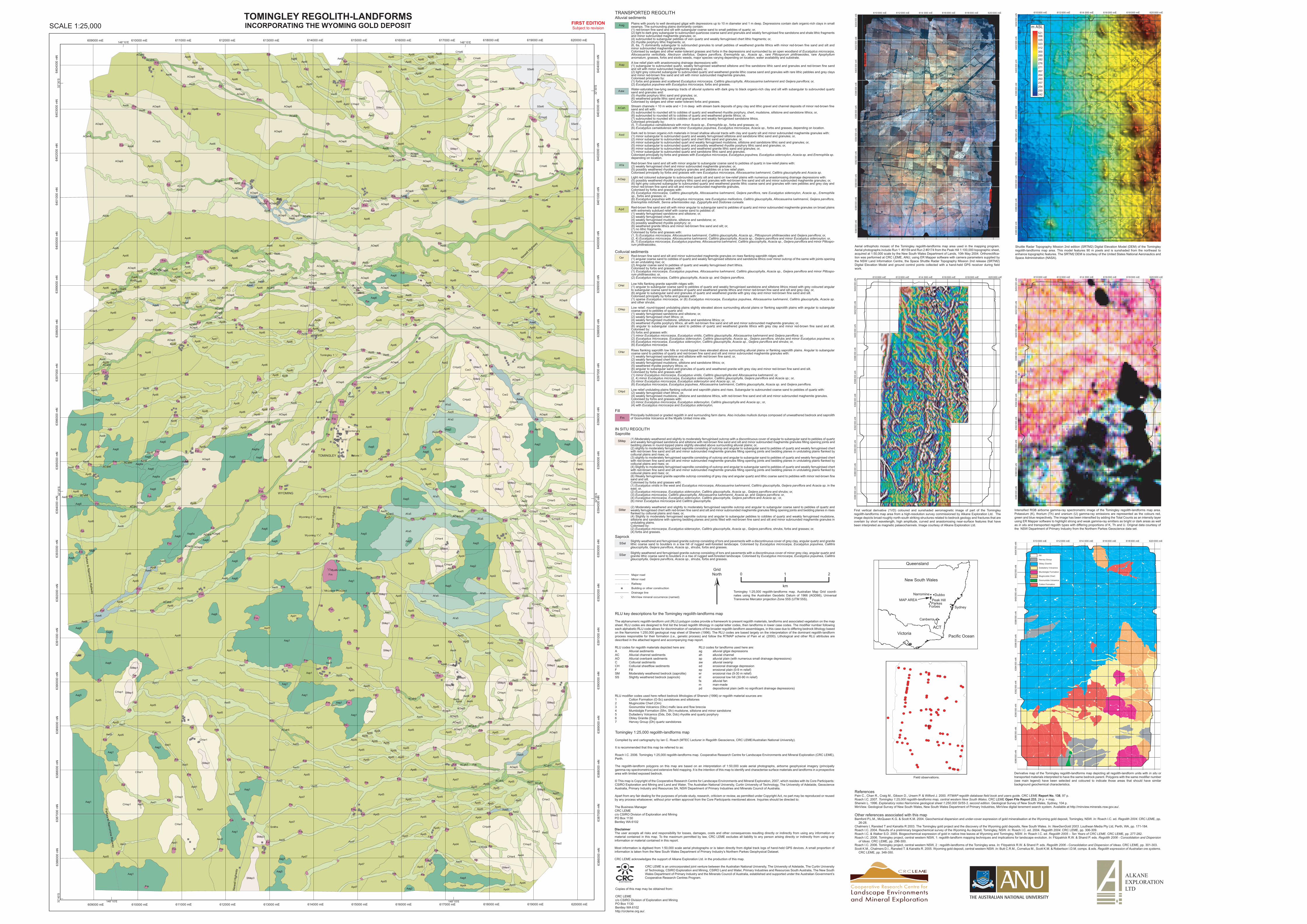
TOMINGLEY REGOLITH-LANDFORMSINCORPORATING THE WYOMING GOLD DEPOSITSCALE 1:25,000

TRANSPORTED REGOLITHAlluvial sediments

Colluvial sediments

Fill

FmPrincipally bulldozed or graded regolith in and surrounding farm dams. Also includes mullock dumps composed of unweathered bedrock and saprolith of Goonumbla Volcanics at the Myalls United mine site.

IN SITU REGOLITHSaprolite

SMep (1) Moderately weathered and slightly to moderately ferruginised outcrop with a discontinuous cover of angular to subangular sand to pebbles of quartz and weakly ferruginised sandstone and siltstone with red-brown fine sand and silt and minor subrounded maghemite granules filling opening joints and bedding planes in round-topped plains slightly elevated above surrounding alluvial plains; or,(2) slightly to moderately ferruginised saprolite consisting of outcrop and angular to subangular sand to pebbles of quartz and weakly ferruginised chert with red-brown fine sand and silt and minor subrounded maghemite granules filling opening joints and bedding planes in undulating plains flanked by colluvial plains and rises; or,(3) slightly to moderately ferruginised saprolite consisting of outcrop and angular to subangular sand to pebbles of quartz and weakly ferruginised chert with red-brown fine sand and silt and minor subrounded maghemite granules filling opening joints and bedding planes in undulating plains flanked by colluvial plains and rises; or,(4) Slightly to moderately ferruginised saprolite consisting of outcrop and angular to subangular sand to pebbles of quartz and weakly ferruginised chert with red-brown fine sand and silt and minor subrounded maghemite granules filling opening joints and bedding planes in undulating plains flanked by colluvial plains and rises; or,(6) Weakly ferruginised granite saprolite outcrop consisting of grey clay and angular quartz and lithic coarse sand to pebbles with minor red-brown fine sand and silt. Colonised by forbs and grasses with:(1) Eucalyptus viridis in the west and Eucalyptus microcarpa, Allocasuarina luehmannii, Callitris glaucophylla, Geijera parviflora and Acacia sp. in the east; or,(2) Eucalyptus microcarpa, Eucalyptus sideroxylon, Callitris glaucophylla, Acacia sp., Geijera parviflora and shrubs; or,(3) Eucalyptus microcarpa, Callitris glaucophylla, Allocasuarina luehmannii, Acacia sp. and Geijera parviflora; or,(4) Eucalyptus microcarpa, Eucalyptus sideroxylon, Callitris glaucophylla, Geijera parviflora and Acacia sp.; or,(6) minor Eucalyptus microcarpa and Callitris glaucophylla.

SMer(2) Moderately weathered and slightly to moderately ferruginised saprolite outcrop and angular to subangular coarse sand to pebbles of quartz and weakly ferruginised chert with red-brown fine sand and silt and minor subrounded maghemite granules filling opening joints and bedding planes in rises flanked by colluvial plains and rises; or,(4) Slightly to moderately ferruginised saprolite outcrop and angular to subangular pebbles to cobbles of quartz and weakly ferruginised mudstone, siltstone and sandstone with opening bedding planes and joints filled with red-brown fine sand and silt and minor subrounded maghemite granules in undulating plains. Colonised by:(2) Eucalyptus microcarpa, Eucalyptus sideroxylon, Callitris glaucophylla, Acacia sp., Geijera parviflora, shrubs, forbs and grasses; or,(4) forbs and grasses.

SSelSlightly weathered and ferruginised granite outcrop consisting of tors and pavements with a discontinuous cover of grey clay, angular quartz and granite lithic coarse sand to boulders in a low hill of rugged well-forested landscape. Colonised by Eucalyptus microcarpa, Eucalyptus populnea, Callitris glaucophylla, Geijera parviflora, Acacia sp., shrubs, forbs and grasses.

SSer Slightly weathered and ferruginised granite outcrop consisting of tors and pavements with a discontinuous cover of minor grey clay, angular quartz and granite lithic coarse sand to boulders in a rise of rugged well-forested landscape. Colonised by Eucalyptus microcarpa, Eucalyptus populnea, Callitris glaucophylla, Geijera parviflora, Acacia sp., shrubs, forbs and grasses.

Saprock

RLU key descriptions for the Tomingley regolith-landforms map

The alphanumeric regolith-landform unit (RLU) polygon codes provide a framework to present regolith materials, landforms and associated vegetation on the map sheet. RLU codes are designed to first list the broad regolith lithology in capital letter codes, then landforms in lower case codes. The modifier number following each alphabetic RLU code allows for discrimination of variations of the broader regolith-landform assemblages, in this case due to differing bedrock lithology based on the Narromine 1:250,000 geological map sheet of Sherwin (1996). The RLU codes are based largely on the interpretation of the dominant regolith-landform process responsible for their formation (i.e., genetic process) and follow the RTMAP scheme of Pain et al. (2000). Lithological and other RLU attributes are described in the attached legend and accompanying map report.

RLU codes for regolith materials depicted here are: RLU codes for landforms used here are: A Alluvial sediments ag alluvial gilgai depressions AC Alluvial channel sediments ah alluvial channel AO Alluvial overbank sediments ap alluvial plain (with numerous small drainage depressions) C Colluvial sediments aw alluvial swamp CH Colluvial sheetflow sediments ed erosional drainage depression F Fill ep erosional plain (0-9 m relief) SM Moderately weathered bedrock (saprolite) er erosional rise (9-30 m relief) SS Slightly weathered bedrock (saprock) el erosional low hill (30-90 m relief) fa alluvial fan m man-made pd depositional plain (with no significant drainage depressions)

RLU modifier codes used here reflect bedrock lithologies of Sherwin (1996) or regolith material sources are:1 Cotton Formation (O-Sc) sandstones and siltstones2 Mugincoble Chert (Om) 3 Goonumbla Volcanics (Obv) mafic lava and flow breccia4 Mumbidgle Formation (Sfm, Sfv) mudstone, siltstone and minor sandstone5 Dulladerry Volcanics (Dds, Ddr, Ddc) rhyolite and quartz porphyry6 Obley Granite (Dog)7 Hervey Group (Dh) quartz sandstones

0 1 2

km

GridNorth

Tomingley 1:25,000 regolith-landforms map. Australian Map Grid coordi-nates using the Australian Geodetic Datum of 1966 (AGD66), Universal Transverse Mercator projection Zone 55S (UTM 55S).

Tomingley 1:25,000 regolith-landforms map

Compiled by and cartography by Ian C. Roach (MTEC Lecturer in Regolith Geoscience, CRC LEME/Australian National University).

It is recommended that this map be referred to as:

Roach I.C. 2006. Tomingley 1:25,000 regolith-landforms map. Cooperative Research Centre for Landscape Environments and Mineral Exploration (CRC LEME), Perth.

The regolith-landform polygons on this map are based on an interpretation of 1:50,000 scale aerial photographs, airborne geophysical imagery (principally gamma-ray spectrometrics) and extensive field mapping. It is the intention of this map to identify and characterise surface materials and landforms in a prospective area with limited exposed bedrock.

© This map is Copyright of the Cooperative Research Centre for Landscape Environments and Mineral Exploration, 2007, which resides with its Core Participants: CSIRO Exploration and Mining and Land and Water, The Australian National University, Curtin University of Technology, The University of Adelaide, Geoscience Australia, Primary Industry and Resources SA, NSW Department of Primary Industries and Minerals Council of Australia.

Apart from any fair dealing for the purposes of private study, research, criticism or review, as permitted under Copyright Act, no part may be reproduced or reused by any process whatsoever, without prior written approval from the Core Participants mentioned above. Inquiries should be directed to:

The Business ManagerCRC LEMEc/o CSIRO Division of Exploration and MiningPO Box 1130Bentley WA 6102

DisclaimerThe user accepts all risks and responsibility for losses, damages, costs and other consequences resulting directly or indirectly from using any information or material contained in this map. To the maximum permitted by law, CRC LEME excludes all liability to any person arising directly or indirectly from using any information or material contained in this report.

Most information is digitised from 1:50,000 scale aerial photographs or is taken directly from digital track logs of hand-held GPS devices. A small proportion of information is taken from the New South Wales Department of Primary Industry’s Northern Parkes Geophysical Dataset.

CRC LEME acknowledges the support of Alkane Exploration Ltd. in the production of this map.

CRC LEME is an unincorporated joint venture between the Australian National University, The University of Adelaide, The Curtin University of Technology, CSIRO Exploration and Mining, CSIRO Land and Water, Primary Industries and Resources South Australia, The New South Wales Department of Primary Industry and the Minerals Council of Australia, established and supported under the Australian Government’s Cooperative Research Centres Program.

Copies of this map may be obtained from:

CRC LEMEc/o CSIRO Division of Exploration and MiningPO Box 1130Bentley WA 6102http://crcleme.org.au/.

FIRST EDITIONSubject to revision

6404

000

mN

6403

000

mN

6402

000

mN

6399

000

mN

6395

000

mN

6396

000

mN

6397

000

mN

6398

000

mN

6400

000

mN

6392

000

mN

6393

000

mN

6394

000

mN

6401

000

mN

6391

000

mN

6386

000

mN

6387

000

mN

6388

000

mN

6389

000

mN

6390

000

mN

619000 mE 620000 mE614000 mE 615000 mE 616000 mE 617000 mE 618000 mE613000 mE609000 mE 610000 mE 611000 mE 612000 mE

TOMINGLEY

WYOMING

New

ell H

ighw

ay

New

ell H

ighw

ay

Newell

High

way

Aag Plains with poorly to well developed gilgai with depressions up to 10 m diameter and 1 m deep. Depressions contain dark organic-rich clays in small swamps. The surrounding plains dominantly contain:(1) red-brown fine sand and silt with subangular coarse sand to small pebbles of quartz; or, (2) light to dark grey subangular to subrounded quartzose coarse sand and granules and weakly ferruginised fine sandstone and shale lithic fragments and minor subrounded maghemite granules; or,(4) subrounded to subangular pebbles of vein quartz and weakly ferruginised chert lithic fragments; or,(5) rhyolite porphyry lithic fragments; or,(6, 6a, 7) dominantly subangular to subrounded granules to small pebbles of weathered granite lithics with minor red-brown fine sand and silt and minor subrounded maghemite granules. Colonised by sedges and other water-tolerant grasses and forbs in the depressions and surrounded by an open woodland of Eucalyptus microcarpa, Allocasuarina verticillata, Alectryon oleifolius, Geijera parviflora, Eremophila sp., Acacia sp., rare Pittosporum philliraeoides, rare Apophyllum anomalum, grasses, forbs and exotic weeds, major species varying depending on location, water availability and substrate.

AapA low relief plain with anastomosing drainage depressions with:(1) subangular to subrounded quartz, weakly ferruginised weathered siltstone and fine sandstone lithic sand and granules and red-brown fine sand and silt with minor subrounded maghemite granules; or,(2) light grey coloured subangular to subrounded quartz and weathered granite lithic coarse sand and granules with rare lithic pebbles and grey clays and minor red-brown fine sand and silt with minor subrounded maghemite granules.Colonised principally by:(1) forbs and grasses and scattered Eucalyptus microcarpa, Callitris glaucophylla, Allocasuarina luehmannii and Geijera parviflora; or,(2) Eucalyptus populnea with Eucalyptus microcarpa, forbs and grasses.

Aaw Water-saturated low-lying swampy tracts of alluvial systems with dark grey to black organic-rich clay and silt with subangular to subrounded quartz sand and granules and: (5) rhyolite porphyry lithic sand and granules; or,(6) weathered granite lithic sand and granules. Colonised by sedges and other water-tolerant forbs and grasses.

ACah Stream channels < 10 m wide and < 3 m deep with stream bank deposits of grey clay and lithic gravel and channel deposits of minor red-brown fine sand and silt with:(5) subrounded to rounded silt to cobbles of quartz and weathered rhyolite porphyry, chert, mudstone, siltstone and sandstone lithics; or,(6) subrounded to rounded silt to cobbles of quartz and weathered granite lithics; or,(7) subrounded to rounded silt to cobbles of quartz and weakly ferruginised sandstone lithics. Colonised principally by:(5, 7) Eucalyptus camaldulensis with minor Acacia sp., Eremophila sp., forbs and grasses; or,(6) Eucalyptus camaldulensis with minor Eucalyptus populnea, Eucalyptus microcarpa, Acacia sp., forbs and grasses, depending on location.

Aed Dark red to brown organic-rich materials in broad shallow alluvial tracts with clay and quartz silt and minor subrounded maghemite granules with:(1) minor subangular to subrounded quartz and weakly ferruginised siltstone and sandstone lithic sand and granules; or,(2) minor subangular to subrounded quartz and chert lithic sand and granules; or,(4) minor subangular to subrounded quart and weakly ferruginised mudstone, siltstone and sandstone lithic sand and granules; or,(5) minor subangular to subrounded quartz and possibly weathered rhyolite porphyry lithic sand and granules; or,(6) minor subangular to subrounded quartz and weathered granite lithic sand and granules; or,(7) minor subangular to subrounded quartz and sandstone lithic sand and granules. Colonised principally by forbs and grasses with Eucalyptus microcarpa, Eucalyptus populnea, Eucalyptus sideroxylon, Acacia sp. and Eremophila sp. depending on location.

Cer Red-brown fine sand and silt and minor subrounded maghemite granules on rises flanking saprolith ridges with:(1) angular coarse sand to cobbles of quartz and weakly ferruginised siltstone and sandstone lithics over minor outcrop of the same with joints opening on an undulating rise; or,(2) Angular coarse sand to pebbles of quartz and weakly ferruginised chert lithics. Colonised by forbs and grasses with:(1) Eucalyptus microcarpa, Eucalyptus populnea, Allocasuarina luehmannii, Callitris glaucophylla, Acacia sp., Geijera parviflora and minor Pittospo-rum philliraeoides; or,(2) Eucalyptus microcarpa, Callitris glaucophylla, Acacia sp. and Geijera parviflora.

CHel Low hills flanking granite saprolith ridges with: (1) angular to subangular coarse sand to pebbles of quartz and weakly ferruginised sandstone and siltstone lithics mixed with grey coloured angular to subangular coarse sand to pebbles of quartz and weathered granite lithics and minor red-brown fine sand and silt and grey clay; or,(6) angular to subangular sand and granules of quartz and weathered granite with grey clay and minor red-brown fine sand and silt.Colonised principally by forbs and grasses with:(1) sparse Eucalyptus microcarpa, or (6) Eucalyptus microcarpa, Eucalyptus populnea, Allocasuarina luehmannii, Callitris glaucophylla, Acacia sp. and other shrubs.

CHep Low relief, round-topped undulating plains slightly elevated above surrounding alluvial plains or flanking saprolith plains with angular to subangular coarse sand to pebbles of quartz and:(1) weakly ferruginised sandstone and siltstone; or,(2) weakly ferruginised chert lithics; or,(4) weakly ferruginised mudstone, siltstone and sandstone lithics; or,(5) weathered rhyolite porphyry lithics, all with red-brown fine sand and silt and minor subrounded maghemite granules; or,(6) angular to subangular coarse sand to pebbles of quartz and weathered granite lithics with grey clay and minor red-brown fine sand and silt. Colonised by:(5) forbs and grasses with:(1) minor Eucalyptus microcarpa, Eucalyptus viridis, Callitris glaucophylla, Allocasuarina luehmannii and Geijera parviflora; or,(2) Eucalyptus microcarpa, Eucalyptus sideroxylon, Callitris glaucophylla, Acacia sp., Geijera parviflora, shrubs and minor Eucalyptus populnea; or, (4) Eucalyptus microcarpa, Eucalyptus sideroxylon, Callitris glaucophylla, Acacia sp., Geijera parviflora and shrubs; or,(6) Eucalyptus microcarpa.

CHer Rises flanking saprolith low hills or round-topped rises elevated above surrounding alluvial plains or flanking saprolith plains. Angular to subangular coarse sand to pebbles of quartz and red-brown fine sand and silt and minor subrounded maghemite granules with:(1) weakly ferruginised sandstone and siltstone with red-brown fine sand; or,(2) weakly ferruginised chert lithics: or,(4) weakly ferruginised mudstone, siltstone and sandstone lithics; or,(5) weathered rhyolite porphyry lithics; or,(6) angular to subangular sand and granules of quartz and weathered granite with grey clay and minor red-brown fine sand and silt.Colonised by forbs and grasses with:(1) minor Eucalyptus microcarpa, Eucalyptus viridis, Callitris glaucophylla and Allocasuarina luehmannii; or,(2, 4) minor Eucalyptus microcarpa, Eucalyptus sideroxylon, Callitris glaucophylla, Geijera parviflora and Acacia sp.; or,(5) minor Eucalyptus microcarpa, Eucalyptus sideroxylon and Acacia sp.; or, (6) Eucalyptus microcarpa, Eucalyptus populnea, Allocasuarina luehmannii, Callitris glaucophylla, Acacia sp. and Geijera parviflora.

CHpd Low relief undulating plains flanking colluvial and saprolith plains and rises. Subangular to subrounded coarse sand to pebbles of quartz with:(2) weakly ferruginised chert lithics; or,(4) weakly ferruginised mudstone, siltstone and sandstone lithics, with red-brown fine sand and silt and minor subrounded maghemite granules. Colonised by forbs and grasses with:(2) minor Eucalyptus microcarpa, Eucalyptus sideroxylon, Callitris glaucophylla and Acacia sp.; or,(4) with Eucalyptus microcarpa and Eucalyptus sideroxylon,

Afa Red-brown fine sand and silt with minor angular to subangular coarse sand to pebbles of quartz in low-relief plains with: (2) weakly ferruginised chert and minor subrounded maghemite granules; or, (5) possibly weathered rhyolite porphyry granules and pebbles on a low relief plain. Colonised principally by forbs and grasses with rare Eucalyptus microcarpa, Allocasuarina luehmannii, Callitris glaucophylla and Acacia sp.

AOap Light red coloured subangular to subrounded quartz silt and sand on low-relief plains with numerous anastomosing drainage depressions with: (5) possibly weathered rhyolite porphyry lithic sand and granules with red-brown fine sand and silt and minor subrounded maghemite granules; or,(6) light grey coloured subangular to subrounded quartz and weathered granite lithic coarse sand and granules with rare pebbles and grey clay and minor red-brown fine sand and silt and minor subrounded maghemite granules,Colonised by forbs and grasses with:(5) Eucalyptus microcarpa, Callitris glaucophylla, Allocasuarina luehmannii, Geijera parviflora, rare Eucalyptus sideroxylon, Acacia sp., Eremophila sp., forbs and grasses; or,(6) Eucalyptus populnea with Eucalyptus microcarpa, rare Eucalyptus melliodora, Callitris glaucophylla, Allocasuarina luehmannii, Geijera parviflora, Eremophila mitchellii, Senna artemisioides ssp. Zygophylla and Dodonea cuneata.

Apd Red-brown fine sand and silt with minor angular to subangular sand to pebbles of quartz and minor subrounded maghemite granules on broad plains with extremely subdued relief with coarse sand to pebbles of:(1) weakly ferruginised sandstone and siltstone; or,(2) weakly ferruginised chert; or,(4) weakly ferruginised mudstone, siltstone and sandstone; or,(5) possibly weathered rhyolite porphyry; or,(6) weathered granite lithics and minor red-brown fine sand and silt; or,(7) no lithic fragments, Colonised by forbs and grasses with:(1, 5) Eucalyptus microcarpa, Allocasuarina luehmannii, Callitris glaucophylla, Acacia sp., Pittosporum philliraeoides and Geijera parviflora; or,(2, 4) Eucalyptus microcarpa, Allocasuarina luehmannii, Callitris glaucophylla, Acacia sp., Geijera parviflora and minor Eucalyptus sideroxylon; or,(6, 7) Eucalyptus microcarpa, Eucalyptus populnea, Allocasuarina luehmannii, Callitris glaucophylla, Acacia sp., Geijera parviflora and minor Pittospo-rum philliraeoides.

Parkes to Narrom

ine Railw

ay

Parkes to Narrom

ine Railw

ay

MinView mineral occurrence (named)

� Building or other construction

Major roadMinor roadRailway

Drainage line

Field observations.

New South Wales

Queensland

Victoria Pacific Ocean

● ●

●●

ACT

Canberra

ParkesForbes

DubboNarromine

Peak HillMAP AREA

Sydney

32°4

0’S

32°3

5’S

32°3

0’S

148°10’E 148°15’E

619000 mE 620000 mE614000 mE 615000 mE 616000 mE 617000 mE 618000 mE613000 mE609000 mE 610000 mE 611000 mE 612000 mE148°10’E 148°15’E

6404

000

mN

6403

000

mN

6402

000

mN

6399

000

mN

6395

000

mN

6396

000

mN

6397

000

mN

6398

000

mN

6400

000

mN

6392

000

mN

6393

000

mN

6394

000

mN

6401

000

mN

6391

000

mN

6386

000

mN

6387

000

mN

6388

000

mN

6389

000

mN

6390

000

mN

32°3

5’S

32°3

0’S