Embed Size (px)
Citation preview
Central Massachusetts Regional Planning Commission 2 Washington Square, Union Station, 2nd Floor, Worcester, MA 01604-4016
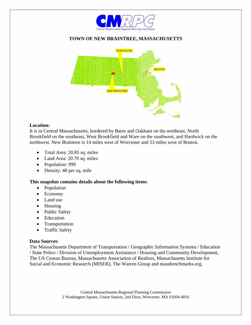
TOWN OF NEW BRAINTREE, MASSACHUSETTS
Location: It is in Central Massachusetts, bordered by Barre and Oakham on the northeast, North Brookfield on the southeast, West Brookfield and Ware on the southwest, and Hardwick on the northwest. New Braintree is 14 miles west of Worcester and 53 miles west of Boston.
Total Area: 20.85 sq. miles Land Area: 20.70 sq. miles Population: 999 Density: 48 per sq. mile
This snapshot contains details about the following items:
Population Economy Land use Housing Public Safety Education Transportation Traffic Safety
Data Sources: The Massachusetts Department of Transportation / Geographic Information Systems / Education / State Police / Division of Unemployment Assistance / Housing and Community Development, The US Census Bureau, Massachusetts Association of Realtors, Massachusetts Institute for Social and Economic Research (MISER), The Warren Group and massbenchmarks.org.
NEW BRAINTREE
BOSTON
WORCESTER
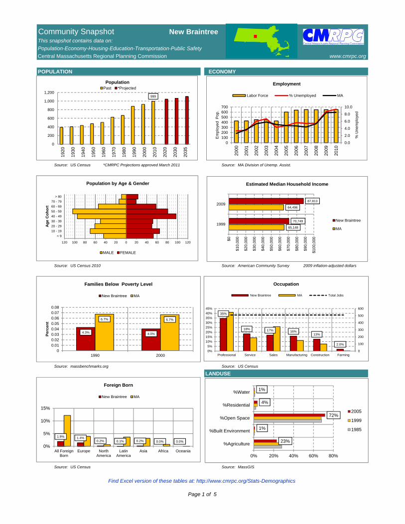
Community Snapshot New BraintreeThis snapshot contains data on:
Population-Economy-Housing-Education-Transportation-Public Safety
Central Massachusetts Regional Planning Commission www.cmrpc.org
POPULATION ECONOMY
Source: US Census *CMRPC Projections approved March 2011 Source: MA Division of Unemp. Assist.
Source: US Census 2010 Source: American Community Survey 2009 inflation-adjusted dollars
Source: massbenchmarks.org Source: US Census
LANDUSE
Source: US Census Source: MassGIS
999
0
200
400
600
800
1,000
1,200
1920
1930
1940
1950
1960
1970
1980
1990
2000
2010
2020
2030
2035
PopulationPast *Projected
0.0
2.0
4.0
6.0
8.0
10.0
0100200300400500600700
2000
2001
2002
2003
2004
2005
2006
2007
2008
2009
2010
% U
ne
mp
loye
d
Em
plo
yed
Po
p.
Employment
Labor Force % Unemployed MA
65,148
64,496
70,749
87,813
$0
$10
,00
0
$20
,00
0
$30
,00
0
$40
,00
0
$50
,00
0
$60
,00
0
$70
,00
0
$80
,00
0
$90
,00
0
$10
0,0
00
1999
2009
Estimated Median Household Income
New Braintree
MA
4.3% 4.0%
6.7% 6.7%
00.010.020.030.040.050.060.070.08
1990 2000
Pe
rce
nt
Families Below Poverty Level
New Braintree MA
1.9% 1.4%0.2% 0.1% 0.2% 0.0% 0.0%
0%
5%
10%
15%
All ForeignBorn
Europe NorthAmerica
LatinAmerica
Asia Africa Oceania
Foreign Born
New Braintree MA
35%
18% 17% 16%13%
2.0%
0
100
200
300
400
500
600
0%
5%
10%
15%
20%
25%
30%
35%
40%
45%
Professional Service Sales Manufacturing Construction Farming
Occupation
New Braintree MA Total Jobs
< 9
10 - 19
20 - 29
30 - 39
40 - 49
50 - 59
60 - 69
70 - 79
> 80
120 100 80 60 40 20 0 20 40 60 80 100 120
Ag
e C
oh
ort
Population by Age & Gender
MALE FEMALE
23%
1%
72%
4%
1%
0% 20% 40% 60% 80%
%Agriculture
%Built Environment
%Open Space
%Residential
%Water
2005
1999
1985
Find Excel version of these tables at: http://www.cmrpc.org/Stats-Demographics
Page 1 of 5
Community Snapshot New BraintreeThis snapshot contains data on:
Population-Economy-Housing-Education-Transportation-Public Safety
Central Massachusetts Regional Planning Commission www.cmrpc.org
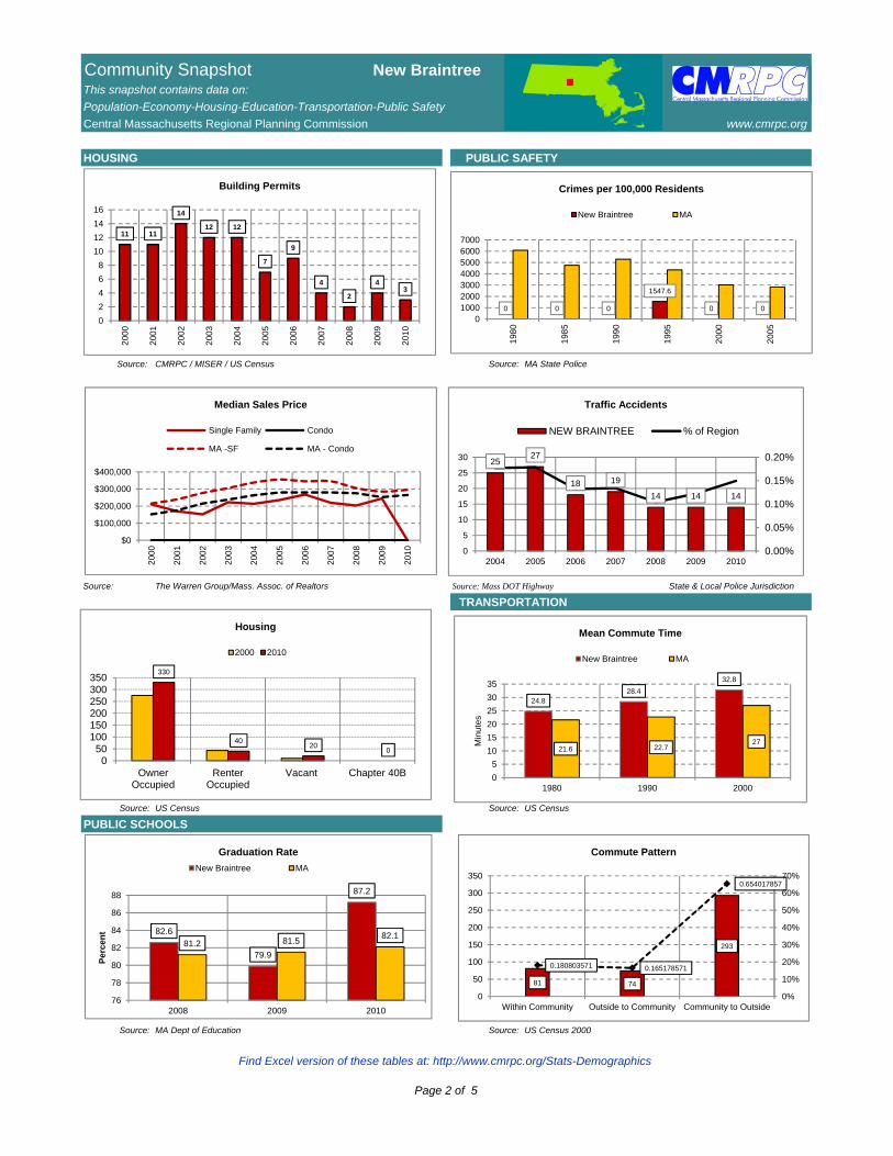
HOUSING PUBLIC SAFETY
Source: CMRPC / MISER / US Census Source: MA State Police
Source: The Warren Group/Mass. Assoc. of Realtors Source: Mass DOT Highway State & Local Police Jurisdiction
TRANSPORTATION
Source: US Census Source: US Census
PUBLIC SCHOOLS
Source: MA Dept of Education Source: US Census 2000
11 11
14
12 12
7
9
4
2
43
0
2
4
6
8
10
12
14
16
200
0
200
1
200
2
200
3
200
4
200
5
200
6
200
7
200
8
200
9
201
0
Building Permits
$0
$100,000
$200,000
$300,000
$400,000
200
0
200
1
200
2
200
3
200
4
200
5
200
6
200
7
200
8
200
9
201
0Median Sales Price
Single Family Condo
MA -SF MA - Condo
0 0 0
1547.6
0 0
01000200030004000500060007000
198
0
198
5
199
0
199
5
200
0
200
5
Crimes per 100,000 Residents
New Braintree MA
2527
18 19
14 14 14
0.00%
0.05%
0.10%
0.15%
0.20%
0
5
10
15
20
25
30
2004 2005 2006 2007 2008 2009 2010
Traffic Accidents
NEW BRAINTREE % of Region
24.828.4
32.8
21.6 22.727
0
5
10
15
20
25
30
35
1980 1990 2000
Min
ute
s
Mean Commute Time
New Braintree MA
81 74
293
0.180803571 0.165178571
0.654017857
0%
10%
20%
30%
40%
50%
60%
70%
0
50
100
150
200
250
300
350
Within Community Outside to Community Community to Outside
Commute Pattern
330
4020
0
050
100150200250300350
OwnerOccupied
RenterOccupied
Vacant Chapter 40B
Housing
2000 2010
82.6
79.9
87.2
81.2 81.582.1
76
78
80
82
84
86
88
2008 2009 2010
Pe
rce
nt
Graduation Rate
New Braintree MA
Find Excel version of these tables at: http://www.cmrpc.org/Stats-Demographics
Page 2 of 5
Community Snapshot New BraintreeThis snapshot contains data on:
Population-Economy-Housing-Education-Transportation-Public Safety
Central Massachusetts Regional Planning Commission www.cmrpc.org
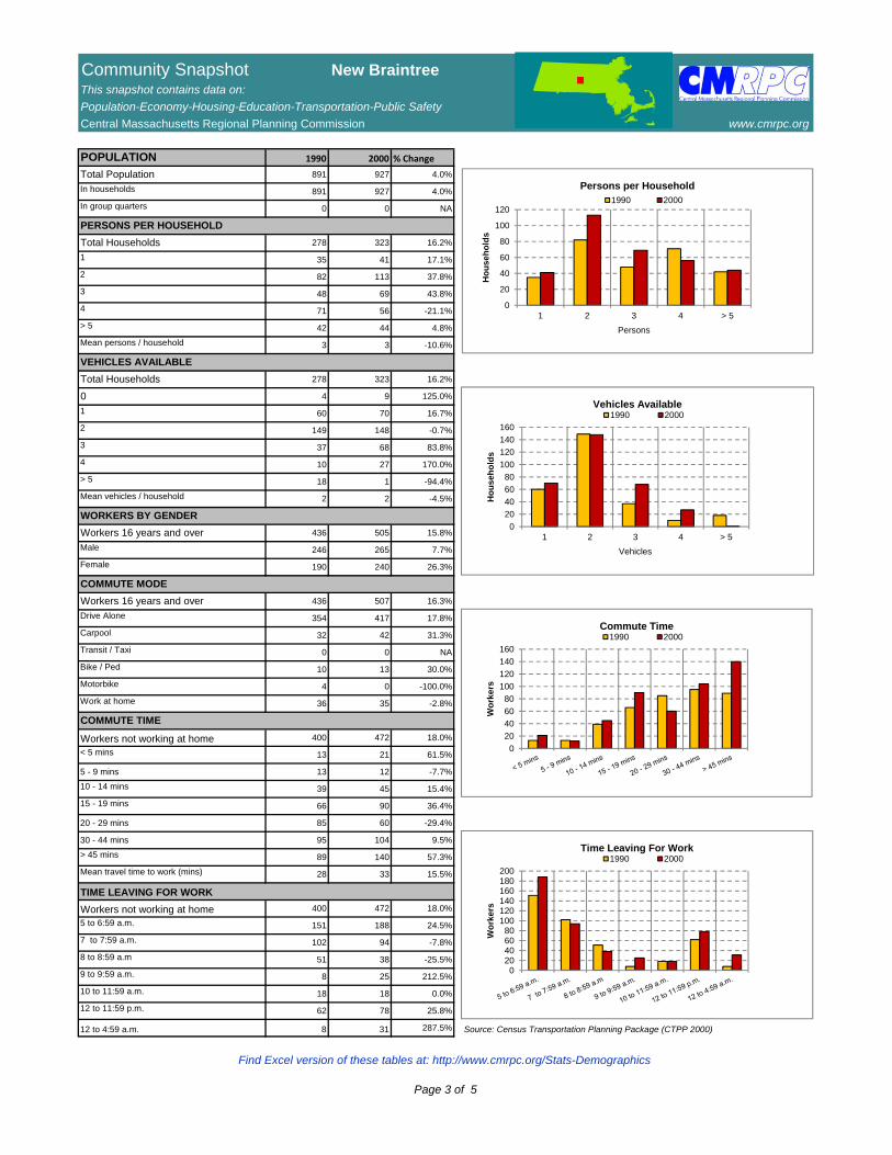
POPULATION 1990 2000 % Change
Total Population 891 927 4.0%
In households 891 927 4.0%
In group quarters 0 0 NA
PERSONS PER HOUSEHOLD
Total Households 278 323 16.2%
1 35 41 17.1%
2 82 113 37.8%
3 48 69 43.8%
4 71 56 -21.1%
> 5 42 44 4.8%
Mean persons / household 3 3 -10.6%
VEHICLES AVAILABLE
Total Households 278 323 16.2%
0 4 9 125.0%
1 60 70 16.7%
2 149 148 -0.7%
3 37 68 83.8%
4 10 27 170.0%
> 5 18 1 -94.4%
Mean vehicles / household 2 2 -4.5%
WORKERS BY GENDER
Workers 16 years and over 436 505 15.8%
Male 246 265 7.7%
Female 190 240 26.3%
COMMUTE MODE
Workers 16 years and over 436 507 16.3%
Drive Alone 354 417 17.8%
Carpool 32 42 31.3%
Transit / Taxi 0 0 NA
Bike / Ped 10 13 30.0%
Motorbike 4 0 -100.0%
Work at home 36 35 -2.8%
COMMUTE TIME
Workers not working at home 400 472 18.0%
< 5 mins 13 21 61.5%
5 - 9 mins 13 12 -7.7%
10 - 14 mins 39 45 15.4%
15 - 19 mins 66 90 36.4%
20 - 29 mins 85 60 -29.4%
30 - 44 mins 95 104 9.5%
> 45 mins 89 140 57.3%
Mean travel time to work (mins) 28 33 15.5%
TIME LEAVING FOR WORK
Workers not working at home 400 472 18.0%
5 to 6:59 a.m. 151 188 24.5%
7 to 7:59 a.m. 102 94 -7.8%
8 to 8:59 a.m 51 38 -25.5%
9 to 9:59 a.m. 8 25 212.5%
10 to 11:59 a.m. 18 18 0.0%
12 to 11:59 p.m. 62 78 25.8%
12 to 4:59 a.m. 8 31 287.5% Source: Census Transportation Planning Package (CTPP 2000)
0
20
40
60
80
100
120
1 2 3 4 > 5
Ho
use
ho
lds
Persons
Persons per Household1990 2000
0
20
40
60
80
100
120
140
160
1 2 3 4 > 5
Ho
use
ho
lds
Vehicles
Vehicles Available1990 2000
0
20
40
60
80
100
120
140
160
Wo
rke
rs
Commute Time1990 2000
020406080
100120140160180200
Wo
rke
rs
Time Leaving For Work 1990 2000
Find Excel version of these tables at: http://www.cmrpc.org/Stats-Demographics
Page 3 of 5
NEW BRAINTREE
BARRE ROAD
RAVINE ROAD
OLD TURNPIKE ROAD
¬«102
OAKHAM
£¤67
NEW BRAINTREE BARRE ROAD
WEST
ROA
D
OAKH
AM RO
AD
HARD
WIC
K RO
AD
MOORE ROADUTLEY ROAD
WORCESTER ROADWINE ROAD
WES
T BR
OOKF
IELD
ROA
D
RAVINE ROAD
UNITAS ROAD
BARR
ROAD
WEB
B RO
AD
IGOE
ROA
D
PADRE ROAD
MARA ROAD
DENN
IS W
HITN
EY R
OAD
MCKA
Y ROA
D THOMPSON ROAD
TUCKER ROAD
PIER
CE R
OAD
HARDWICK
BARRE
OAKHAM
NORTH BROOKFIELD
WEST BROOKFIELD
WARE
WARREN
SPENCER
PETERSHAM
EAST BROOKFIELD
RUTLAND
£¤67
£¤148
£¤32A
£¤32
£¤9
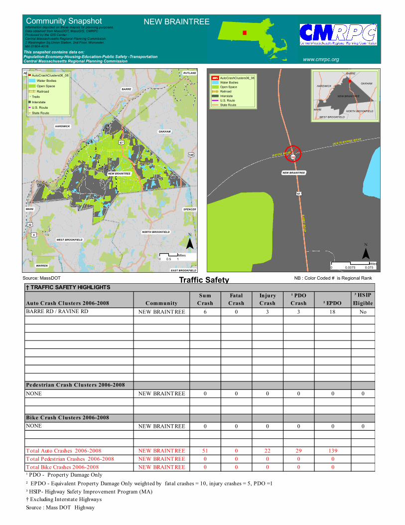
Traffic Safety 0 0.0750.0375
Miles
HARDWICKOAKHAM
NEW BRAINTREE
NORTH BROOKFIELDWEST BROOKFIELD
BARRE
WARE
Community Snapshot NEW BRAINTREE
www.cmrpc.orgThis snapshot contains data on:Population-Economy-Housing-Education-Public Safety -TransportationCentral Massachusetts Regional Planning Commission
Information depicted on these mapsis for planning purposes.Data obtained from MassDOT, MassGIS, CMRPCProduced by the GIS Center :Central Massachusetts Regional Planning Commission.2 Washington Sq,Union Station, 2nd Floor, Worcester, MA 01604-4016
¯0 10.5Miles¯
AutoCrashClusters06_08Water BodiesOpen SpaceRailroadInterstateU.S. RouteState Route
AutoCrashClusters06_08Water BodiesOpen SpaceRailroad
TrailsInterstateU.S. RouteState Route
NB : Color Coded # is Regional RankSource: MassDOT† TRAFFIC SAFETY HIGHLIGHTS
Sum Fatal Injury ¹ PDO ³ HSIPAuto Crash Clusters 2006-2008 Community Crash Crash Crash Crash ² EPDO EligibleBARRE RD / RAVINE RD NEW BRAINTREE 6 0 3 3 18 No
Pedestrian Crash Clusters 2006-2008NONE NEW BRAINTREE 0 0 0 0 0 0
Bike Crash Clusters 2006-2008NONE NEW BRAINTREE 0 0 0 0 0 0
Total Auto Crashes 2006-2008 NEW BRAINTREE 51 0 22 29 139Total Pedestrian Crashes 2006-2008 NEW BRAINTREE 0 0 0 0 0Total Bike Crashes 2006-2008 NEW BRAINTREE 0 0 0 0 0¹ PDO - Property Damage Only² EPDO - Equivalent Property Damage Only weighted by fatal crashes = 10, injury crashes = 5, PDO =1³ HSIP- Highway Safety Improvement Program (MA)† Excluding Interstate HighwaysSource : Mass DOT Highway
£¤67
£¤32A
£¤32
£¤9
£¤148
£¤122
NEW BRAINTREE
BARRE ROAD
WEST
ROA
D
OAKHAM ROAD
HARD
WIC
K RO
AD
MOORE ROADUTLEY ROAD
WORCESTER ROAD
WINE ROAD
WES
T BR
OOKF
IELD
ROA
D
RAVINE ROAD
UNITAS ROAD
BARR
ROAD
WEB
B RO
AD
IGOE
ROA
D
PADRE ROAD
MARA
ROA
D
DENN
IS W
HITN
EY R
OAD
MCKA
Y ROA
D
SCOTT R
OAD
THOMPSON ROAD
BRIDGE ROAD
TUCKER ROAD
BARRE
HARDWICK
OAKHAM
NORTH BROOKFIELDWEST BROOKFIELD
WARE
PETERSHAM
SPENCER
£¤67
£¤32A
£¤32
£¤9
£¤122
NEW BRAINTREE
Brooks Pond: Sapphire Pond
Horse Pond
Ware River
Adams Pond
Cusky Pond
Doane Pond
Brookhaven Lake
Pottapaug Pond
Alt 1T
r ail
New Braintree T rail
Alt 1T
rail
Mass Cent
ral Rail
Trail
Mass C entral Rail T
rail
BARRE ROADWES
T RO
AD
OAKHAM ROAD
MOORE ROADUTLEY ROAD
WORCESTER ROADWINE ROAD
WES
T BR
OOKF
IELD
ROA
D
RAVINE ROAD
UNITAS ROAD
BARR
ROAD
WEB
B RO
AD
IGOE
ROA
D
PADRE ROAD
MARA ROAD
DENN
IS W
HITN
EY R
OAD
SCOTT R
OAD
THOMPSON ROAD
BRIDGE ROAD
TUCKER ROAD
BARRE
HARDWICK
OAKHAM
NORTH BROOKFIELDWEST BROOKFIELD
WARE
PETERSHAM
GRIGAS
WINIMUSSET WMA
WARE RIVER WMA
£¤67
£¤32A
£¤9
£¤148
£¤122
NEW BRAINTREE
BARRE ROAD
WEST
ROA
D
OAKHAM ROAD
HARD
WIC
K RO
AD
MOORE ROADUTLEY ROAD
WORCESTER ROAD
WINE ROAD
WES
T BR
OOKF
IELD
ROA
D
RAVINE ROAD
UNITAS ROAD
BARR
ROAD
WEB
B RO
AD
IGOE
ROA
D
PADRE ROAD
MARA
ROA
D
DENN
IS W
HITN
EY R
OAD
MCKA
Y ROA
D
SCOTT R
OAD
THOMPSON ROAD
BRIDGE ROAD
TUCKER ROAD
HARDWICK
BARRE
OAKHAM
NORTH BROOKFIELDWEST BROOKFIELD
WARE
WARREN
WARE
WARE
PETERSHAM
£¤67
£¤32A
£¤32
£¤9
£¤122
NEW BRAINTREE
BARRE ROAD
WEST
ROA
D
OAKHAM ROAD
HARD
WIC
K RO
AD
MOORE ROADUTLEY ROAD
WORCESTER ROAD
WINE ROAD
WES
T BR
OOKF
IELD
ROA
D
RAVINE ROAD
UNITAS ROAD
BARR
ROAD
WEB
B RO
AD
IGOE
ROA
D
PADRE ROAD
MARA ROAD
DENN
IS W
HITN
EY R
OAD
MCKA
Y ROA
D
SCOTT R
OAD
THOMPSON ROAD
BRIDGE ROAD
TUCKER ROAD
BARRE
HARDWICK
OAKHAM
NORTH BROOKFIELDWEST BROOKFIELD
WARE
PETERSHAM
SPENCER
0 10.5Miles
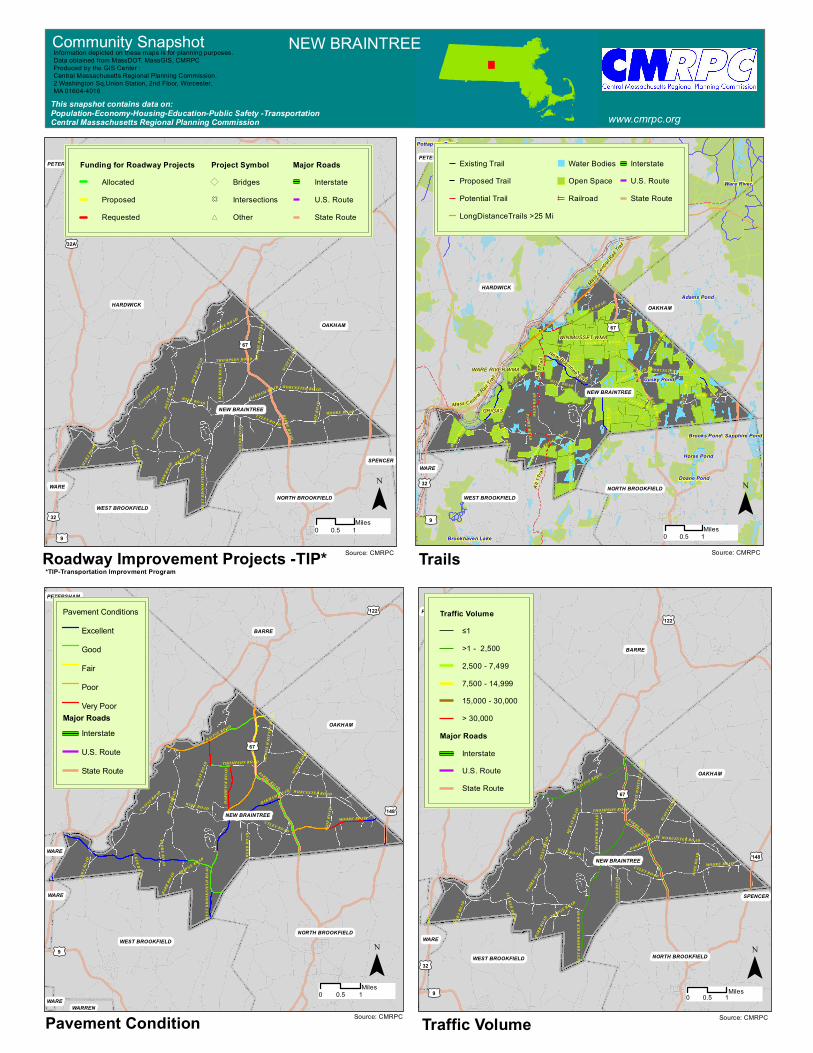
Traffic VolumePavement Condition
Trails
Pavement ConditionsExcellentGoodFairPoorVery Poor
Major RoadsInterstateU.S. RouteState Route
Traffic Volume≤1>1 - 2,5002,500 - 7,4997,500 - 14,99915,000 - 30,000> 30,000
Major RoadsInterstateU.S. RouteState Route
Existing TrailProposed TrailPotential TrailLongDistanceTrails >25 Mi
Water BodiesOpen SpaceRailroad
InterstateU.S. RouteState Route
Funding for Roadway ProjectsAllocatedProposedRequested
Project Symbol) BridgesF Intersections* Other
Major RoadsInterstateU.S. RouteState Route
0 10.5 Miles
0 10.5Miles0 10.5
Miles
Community Snapshot NEW BRAINTREE
www.cmrpc.orgThis snapshot contains data on:Population-Economy-Housing-Education-Public Safety -TransportationCentral Massachusetts Regional Planning Commission
Information depicted on these maps is for planning purposes.Data obtained from MassDOT, MassGIS, CMRPCProduced by the GIS Center :Central Massachusetts Regional Planning Commission.2 Washington Sq,Union Station, 2nd Floor, Worcester, MA 01604-4016
¯ ¯
¯¯Source: CMRPC Source: CMRPC
Source: CMRPC Source: CMRPC
Roadway Improvement Projects -TIP* *TIP-Transportation Improvment Program