Embed Size (px)
Citation preview
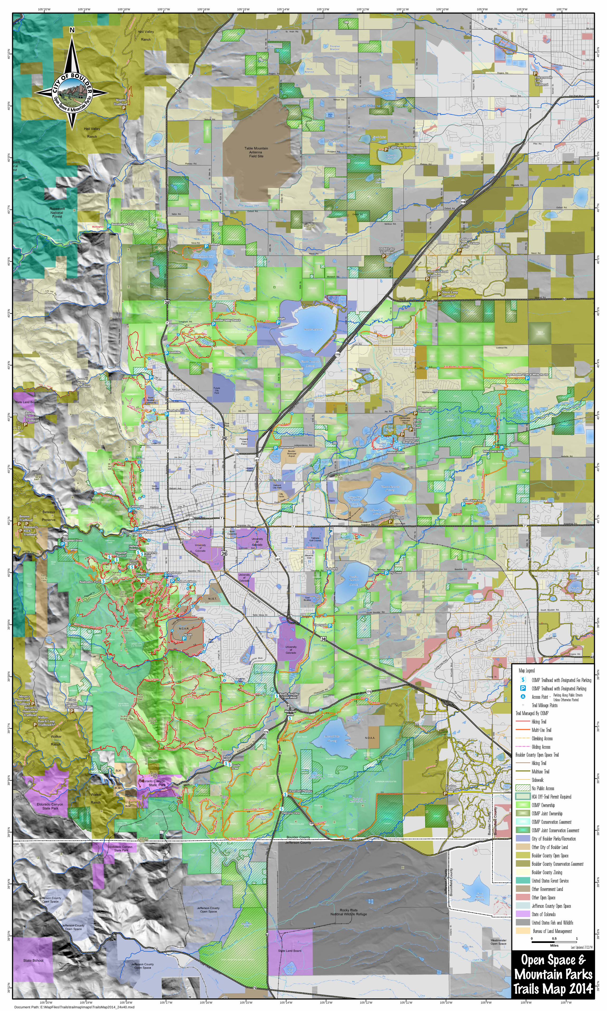
Dodd Reservoir
Leggett-OwenReservoir
Mower Res.
StearnLake
Standley Lake
GreatWestern
Reservoir
UpperChurch Lake
LafayetteReservoir
Ketner Res.
AutreyReservoir
Hodgson-Harris Reservoir
RockyFlatsLake
WanekaReservoir
Reservoir
(Private)
Valmont Reservoir
Teller
Twin Lakes
LefthandReservoir
Swede Lakes
BohnLake
Hillcrest Lake
(Private)
PondFlatirons Vista
KOAPond
EgglestonReservoir No. 3
Allens Res.
TrevartonReservoir
DavisReservoir
Mesa Res.
Pit D
Lake #5
TellerLake #1
HaydenLake
Walden Ponds
SawhillPonds
Burke
Hartman
VieleLake
SpurgeonReservoir
No. 1
JoderReservoir
KosslerLake
Jewel Mtn.Pond
(Private)
(Private)
Culver Pond
#1
(Private)
BaselineReservoir
LouisvilleReservoir
Loukonen Reservoir
Pond 1BVR
Cowdrey
Reservoir No. 2
Marshall Lake
WonderlandLake
EgglestonReservoir No. 4
Clover Basin Reservoir
Gaynor
Lakes
Boulder Reservoir
Lefthand Valley
(Private)
Harper Lake
CootLake
LagermanReservoir
Steele Lakes
Sixmile Reservoir
(Private)
Sombrero Marsh
Diagon
al H
wy.
Bro
ad
wa
y
Balsam Ave.
20th St.
Pearl St.
Arapahoe Rd.
76
th
St.
South Boulder Rd.
Carbon Rd.
Coalton Dr.
McC
aslin
Blvd.
Dillon Rd.
55
th
St.
St. Vrain Rd.
Nelson Rd.
Rogers Rd.
9th Ave.
3rd Ave.
Ken Pratt Blvd.
Pike Rd.
Rogers Rd.
Pike Rd.
Lookout Rd.
Arapahoe Rd.
Nelson Rd.
Plateau Rd.
79
thS
t.
Isabelle Rd.
28t h
St.
30
t hS
t.
Poor m
anR
d.
Canyon Blvd.
University Ave.
28
th S
t.
30
th S
t.
49
th
St.
39
thS
t.
St. Vrain Rd.
N.
63
rdS
t.
Nelson Rd.
Cente
nnial P
kwy.
PineSt.
Pearl Pkwy.
sD
am
Rd.
Ko
ssler
La
keR
d.
Geer
Canyon
Dr.
Empire Dr.
N.
55
th
St.
Air
po
rt
Rd
.
N.
85
th
St.
N.
65
th
St.
Su
nse
t S
t.
Ho
ver
Rd
.
N.
51
st
St.
N.
75
th
St.
N.
75
th
St.
Lef t
ha
nd
Ca
nyo
nD
r.
Rock
Cr. Pkwy.
Lo
okout Rd.
No
rth
wes
tPar
kway
N.
63
rdS
t.
Brainard
10
7th
St
N.
81
st
St.
Pine St.
Ma
in
St.
95
thS
t.
Baseline Rd.
Empire Rd.
Nebo Rd.
Walnut St.
Canyon Blvd.
Arapahoe Ave.
Colorado Ave.
N.
Fo
oth
ills
Hw
y.
Hwy 52
Hw
y9
3
9th
S
t.
75
th S
t
N.
Bro
ad
wa
y
Boulder Canyon Dr.
Fourm
ileC
anyonD
r.
Linde
nD
r.
Old
eS
tag
eR
d.
Lee Hill Rd.
Niwot Rd.
N.
71
st
St.
N.
73
rd
St.
71
stS
t.
63
rd
St.
Jay Rd.
51
st
St.
Mapleton Ave.
17
th
St. Arapahoe Rd.
63
rd S
t.
57
th
St.
Cherryvale Rd.
Tabl
e Mesa Dr.
Ogalalla Rd.
Plateau Rd.
Oxford Rd.
Niwot Rd.
Mineral Rd.
95
th
St.
Oxford Rd.
Nimbus Rd.
N.
39
th
St.
Plateau Rd.
N.
41
st
St.
N.
49
th
St.
Prospect Rd.
Neva Rd.
55
th
St.
McC
asl
in
Blv
d.
88
th S
t.
S.
96
thS
t.
Via Appia
Fo
oth
ills
Pkw
y.
Edgewood D r.
Linden Dr.
Yarmouth Ave.
Table Mesa Dr.
South Boulder Rd.
75
thS
t.
61
stS
t.
Le
hig
h
St.
Moorhead Ave.
Eldorado Springs
Dr.
Biso
n Dr - Priv ate
Ind
ian
a
St.
Baseline Rd.
N.
85
th
St.
Coal Creek Canyon Dr.
55
th
St.
63r
dS
t.
Monarch Rd.
Baseline Rd.
SunshineCanyon
Dr.
Longhorn Rd.
Independence Rd.
Valmont Dr.
Flagstaff Dr.
Broadway
Gre
enbriar Blvd.
Pearl St.
Fo
lso
m
St.
Fo
lso
m
St.
Foo
thill
sP
kwy.
Ch
err
yva
le
Rd
.
S. B
road
way
Marshall Dr.
Dillo
nR
d.
Cherry St.
75
th
St.
Dia
gona
l H
wy.
N.
77
th
St.
N.
83
rdS
t.
Oxford Rd.
Nimbus Rd.
Ou
ray
Dr.
Jay Rd.
Valmont Rd.
19
th
St.
Iris Ave.
Baseline Rd.
95
th
St.
Violet Ave.
LeeHill D r.
28thSt. Ext.
Valmont Dr.
Oxford Rd.
Greenbelt Plateau
MarshallMesa
South BoulderCreek West
HalfwayHouse
FlagstaffSummit
PanaramaPoint
Realization Point
GregoryCanyon
CrownRock
SouthMesa
DoudyDraw
Flatirons Vista
East Boulder Trail at White Rocks
Buckingham Park
Settler’s Park
Centennial
Teller Farm South
Teller Farm NorthCottonwood
Lefthand
Boulder Valley Ranch Eagle
Foothills
Wonderland Lake
Sawhill Ponds
BobolinkDry Creek
Cherryvale
Chautauqua
Enchanted Mesa
NCAR
Chapman Drive
WallyToevsPond
CottonwoodMarsh Pond
Stearn’sLake
Trailhead
Monarch RoadTrailhead
Niwot LoopTrailhead
LefthandValley GrangeTrailh*
WapitiTrailhead
Meyer’sHomestead
Trailhead
WalkerRanch LoopTrailhead/S*
EthelHarrold
Trailhead
Lagerman Trailhead
LegionParkTrailhead
FairgroundsLakeTrailhead
HeatherwoodTrailhead
Meyer’sHomesteadTrailhead
BetassoTrailhead
BaldMountainTrailhead
Dodd LakeTrailhead
Bummer’sRockTrailhead
Anne UWhiteTrailhead
CoaltonTrailhead
105°7’W
105°7’W
105°8’W
105°8’W
105°9’W
105°9’W
105°10’W
105°10’W
105°11’W
105°11’W
105°12’W
105°12’W
105°13’W
105°13’W
105°14’W
105°14’W
105°15’W
105°15’W
105°16’W
105°16’W
105°17’W
105°17’W
105°18’W
105°18’W
105°19’W
105°19’W
105°20’W
105°20’W4
0°1
0’N
40
°10
’N
40
°9’N
40
°9’N
40
°8’N
40
°8’N
40
°7’N
40
°7’N
40
°6’N
40
°6’N
40
°5’N
40
°5’N
40
°4’N
40
°4’N
40
°3’N
40
°3’N
40
°2’N
40
°2’N
40
°1’N
40
°1’N
40
°0’N
40
°0’N
39
°59
’N
39
°59
’N
39
°58
’N
39
°58
’N
39
°57
’N
39
°57
’N
39
°56
’N
39
°56
’N
39
°55
’N
39
°55
’N
39
°54
’N
39
°54
’N
39
°53
’N
39
°53
’N
39
°52
’N
39
°52
’N
OSMP Trailhead with Designated Fee Parking
OSMP Trailhead with Designated Parking
Access Point -
Trail Mileage Points
Trail Managed By OSMP
Hiking Trail
Multi-Use Trail
Climbing Access
Gliding Access
Boulder County Open Space Trail
Hiking Trail
Multiuse Trail
Sidewalk
No Public Access
HCA Off-Trail Permit Required
OSMP Ownership
OSMP Joint Ownership
OSMP Conservation Easement
OSMP Joint Conservation Easement
City of Boulder Parks/Recreation
Other City of Boulder Land
Boulder County Open Space
Boulder County Conservation Easement
Boulder County Zoning
United States Forest Service
Other Government Land
Other Open Space
Jefferson County Open Space
State of Colorado
United States Fish and Wildlife
Bureau of Land Management0 10.5
Miles
Open Space &Mountain ParksTrails Map 2014
Parking Along Public Streets Unless Otherwise Posted
Map Legend
N
Document Path: E:\MapFiles\Trails\trailmap\maps\TrailsMap2014_24x40.mxd
Last Updated 7/22/14