Embed Size (px)
Citation preview
TRAINING MATERIALS FOR LOCAL TRAININGS
ENGLISH VERSION
PART A
Output D.T 2.1.2
1
Content
CONTENT ...................................................................................................................... 1
Introduction ............................................................................................... 2
GreenerSites Web-GIS Tool ............................................................................. 3
Sustainable redevelopment of GreenerSites pilot brownfields in Functional Urban
Areas ....................................................................................................... 10
Former chemical plant “Zachem” in Bydgoszcz, Poland ............................................................ 10
Former railway sleepers preservation plant in Solec Kujawski, Poland ........................................... 12
Former CHP plant in Radom, Poland .................................................................................... 14
Porto Marghera Industrial area in Venice, Italy ....................................................................... 16
Mlaka area in Rijeka, Croatia ............................................................................................. 19
Stara Cinkarna in Celje, Slovenia ........................................................................................ 21
Magdeburg-Rothensee in Magdeburg, Germany ....................................................................... 23
Brownfield site Halle-Ammendorf in Halle (Saale), Germany ...................................................... 25
Figure 1: System Architecture ............................................................................................................................................ 3
Figure 2: Frontend with map viewer ................................................................................................................................... 5
Figure 3: Role-based access control ................................................................................................................................... 5
Figure 4: Editing the attribute table .................................................................................................................................... 6
Figure 5: GeoServer Layer Preview ................................................................................................................................... 9
Figure 6: Layer styling with QGIS ..................................................................................................................................... 9
Figure 7: Aerial view of former “Zachem” chemical plant ............................................................................................... 10
Figure 8: Aerial view of Former railway sleepers preservation plant area ....................................................................... 12
Figure 9: Aerial view of former CHP plant in Radom ...................................................................................................... 14
Figure 10: Brownfield site Porto Marghera Industrial area .............................................................................................. 16
Figure 11: Aerial view of Brownfield site Mlaka area ...................................................................................................... 19
Figure 12: Abandoned industrial area of Stara Cinkarna .................................................................................................. 21
Figure 13: Abandoned industrial area of Stara Cinkarna .................................................................................................. 23
Figure 14: Aerial picture of Halle-Ammendorf (picture credit: Lutz Winkler, Mitteldeutsche Zeitung) .......................... 25
Figure 15: Geographical demarcation of Halle-Ammendorf; graph: isw 2015 ................................................................ 26
2
Introduction
Local trainings are organized within the Interreg Central Europe project GreenerSites Environmental Rehabilitation of Brownfield Sites in Central Europe.
GreenerSites aims at providing the public sector with new skills and know-how on brownfield regeneration in order to improve the sites’ environmental conditions producing a positive impact on the surrounding inhabited areas. Therefore partners organize 9 local trainings for public employees and stakeholders to increase their capacity to effectively manage brownfield regeneration in a sustainable way. Local trainings are part of the skills improvement scheme provided by project that also foresees: 2 transnational trainings, study visits and pilot sites visits.
Local trainings are to provide the knowledge on integrated environmental management, in particular:
the analysis of the brownfield site in each partner city/region,
geo-information tool,
subjects related to brownfield regeneration in local context
The trainings are designed for project partners, associated institution of the project and local stakeholders.
3
GreenerSites Web-GIS Tool
Material prepared by: Stefan Fina/Markus Singer (mena GmbH) and Philipp Zakrzewski (MLV)
1. Overview
The GreenerSites Tool is a site information system for online collaboration of public authorities and other stakeholders that are concerned with brownfield rehabilitation and site development. It is an open source web-GIS tool including only the most essential maps and data. These comprise of basic maps and orthophotos as well as selected thematic maps and a manageable amount of detailed site information. Existing INSPIRE compliant geodata services and other web map services (WMS) can be included (e.g. OpenStreetMap, CORINE LandCover, Urban Atlas). Basic features are data sharing, a map viewer, a search function, spatial analysis functions (via QGIS) and the possibility to create and export fact sheets
The GreenerSites Web-GIS Tool enables partners to equally share their information in a web-based application which can be accessed by all users. Even stakeholders that have no own GIS can look up the maps in the browser. The tool is based on the EU-recommended frame of reference for geodata ETRS89 (European Terrestrial Reference System 1989) and features user-friendly functions of configurable data integration mechanisms. At present the tool is provided in a German and an English version, but the chosen system allows to add further local language versions. The tool has a great future perspective when more interoperable geodata is being published following the INSPIRE Directive (2020: Annex II & III themes).
As the tool is based on open source components it can be used freely by other stakeholders. The Software code can be modified and adjusted to own needs. So the tool is not limited to the once developed functions but can be extended and tailored to the needs of certain stakeholders. It comes with an installation routine allowing setting up the tool easily. Nevertheless to use the tool it needs more than just to open a browser and start working. There has to be a GIS administrator to set up and run the tool, to manage the data, and to administrate the different features and users. If the tool is operated locally the hosting of a GIS server is required.
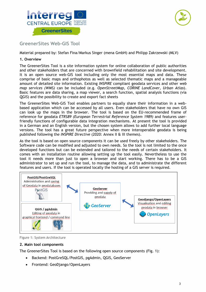
Figure 1: System Architecture
2. Main tool components
The GreenerSites Tool is based on the following open source components (Fig. 1):
Backend: PostGreSQL/PostGIS, pgAdmin, QGIS, GeoServer
Frontend: GeoDjango/OpenLayers
4
PostGreSQL/ PostGIS geodatabase
PostGreSQL is an object-relational database and PostGIS is an extension, which enables saving geographic objects into the database. These are used in the GreenerSites Web-GIS-Tool for:
Saving data
Editing data
Implementation of user roles
Providing data for the GeoServer
The database can either be managed with psql in the command line or with pgAdmin in a graphical user interface. The following versions are used: PostGreSQL 9.5 and PostGIS 2.3.
The PostGreSQL database also contains schemes to manage access of the different user groups.
“public” – open access to all users
“private” - restricted access for registered users with access rights
pgAdmin
The pgAdmin is a GUI (graphical user interface) administration tool for managing data in PostGreSQL.
QGIS
QGIS is a geographic information system with an interface for OGC and rasterdata. It can be used to visualize and edit geodata.
GeoServer
GeoServer is a Java-based map-server that supplies the Web-GIS-Tool with the geodata. Rights defined in the PostGre-database can either be adopted or specified further within the GeoServer. Administrators are able to configure the layer style and appearance with the GeoServer and it is also possible to integrate external geo-services (WMS) into the frontend of the Web-GIS-Tool.
GeoDjango/OpenLayers
GeoDjango is a web framework for geographic data. OpenLayers is a JavaScript library and displays tiled maps in a web browser. The frontend of the map viewer (Fig. 2) is visualized with GeoDjango (layer tree, map view) and OpenLayers (selection of sites, entering attributes, layer order, transparency). https://openlayers.org/ https://www.djangoproject.com/
Each region can use their one subdomain to style and organize their website individually (logos, language, etc.).
5
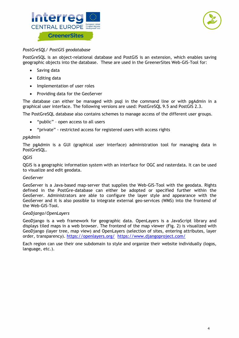
Figure 2: Frontend with map viewer
User roles
The tool uses a role-based access control. Figure 3 is showing the different user roles and their corresponding rights.
User User Description User Rights User example
postgres Superuser/Host/Admin All databases and user roles TBD
gsa Administrator for database in associated region
Edit associated database and defining associated user roles
Data holding authority in region
gsrw Read and write in database
Edit specific attributes, for example site informations (given by gsa)
Registered User (employees/investors)
gsr Read in database Read attributes and print reports Unregistered User
Figure 3: Role-based access control
6
3. How to use the tool
Frontend
Login
By clicking on “Login” and providing username and password a user has access to additional functions depending on his user role.
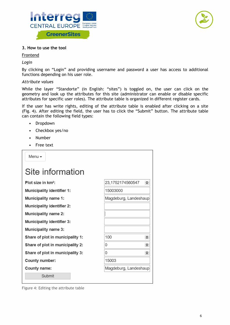
Attribute values
While the layer “Standorte” (in English: “sites”) is toggled on, the user can click on the geometry and look up the attributes for this site (administrator can enable or disable specific attributes for specific user roles). The attribute table is organized in different register cards.
If the user has write rights, editing of the attribute table is enabled after clicking on a site (Fig. 4). After editing the field, the user has to click the “Submit” button. The attribute table can contain the following field types:
• Dropdown
• Checkbox yes/no
• Number
• Free text
Figure 4: Editing the attribute table
7
Factsheet export
After selecting a site geometry a user can click the button “Flächenpass aufrufen” (in English: “display factsheet”) located below the attribute table. A new site will load, showing a picture of the actual map view and the attribute table. By clicking on “Flächenpass herunterladen” (in English: “download factsheet”) the map view and attribute table is exported into a PDF.
Backend
Establishing connection to the Greener Sites System with PuTTY to GeoServer
The following steps have to be followed to connect to the GeoServer
1. Download PuTTY from www.putty.org
2. Start PuTTY Key Generator (PuTTYgen)
3. Click on “Generate” to generate a key
4. Mouse has to be moved until key is generated
5. Paste “Public key”, “Key fingerprint” and “Key comment” for later use in textfile
6. Set a “Key passphrase” and “Confirm passphrase” (this will be your personal password)
7. Click “Save private key”
8. Copy private key onto server
9. Close PuTTYgen
10. Start PuTTY
11. Navigate to “SSH/Auth”
12. Browse for the saved private key generated in PuTTYgen
13. Navigate to “SSH/Tunnels”
14. Add “Source port” and “Destination” and click “Add”
15. Navigate to “Session”
16. Add “Host Name” and “Port”
17. “Open” (The sessions can also be saved for future connections)
18. After providing user and passphrase (created in 6.) the user has access to the GeoServer in the browser
Establishing connection to the Greener Sites database with PuTTY
Establishing connection to the database with PuTTY requires the same steps as shown before except source port and destination are different. After connection is established, data can be imported into the database. This is described in the following section.
Data import
This section shows different methods, how data can be imported into the database
a) Data import with WinSCP
1. Download and install WinSCP from https://winscp.net/
8
2. Import “Sites” from PuTTY
3. Login and passphrase is similar to PuTTY
4. Importing data by drag and drop to the right window in WinSCP
b) Data import with pgAdmin
1. Download and install pgAdmin III from https://www.pgadmin.org/download/
2. Connection via PuTTY to the database is needed (see chapter 5.2)
3. After starting pgAdmin click on “File/Add Server”
4. Fill in: “Name”, “Host”, “Port”, “Maintenance database” and “Username” and click “OK”
5. Right-click on server / Connect
6. Enter password
7. User is now connected to the database and can upload data with the plugin “PostGIS Shapefile and DBF loader”
c) Data import with QGIS
1. Download and install QGIS from http://www.qgis.org/
2. Connection via PuTTY to the database is needed
3. After starting QGIS right-click “PostGIS” in Browser window
4. Click “New Connection” and fill in “Name”, “Host”, “Port”, “Database”, “User Name”, “Password” and click “OK”
5. Importing vector data can now be done with the DB Manager
6. Navigate to “Database”/”DB Manager”
7. Navigate to database GreenerSites
8. Click “Import Layer/File”
9. Browse and choose vector layer
10. Click button “Update Options”
11. You can choose the scheme (e.g. public or private)
12. After “OK” the Shapefile is uploaded to the database
13. After refreshing, update “Extent” and “Spatial Index” of the uploaded vector file
Styling and publishing with GeoServer
Using GeoServer you can manage and publish your layers in the Web-GIS Tool e.g. defining layer groups or define the styling There is also the possibility to check the styling of layers before publishing by clicking “Layer Preview” / “Open Layers” (see Figure 5: Layer Preview).
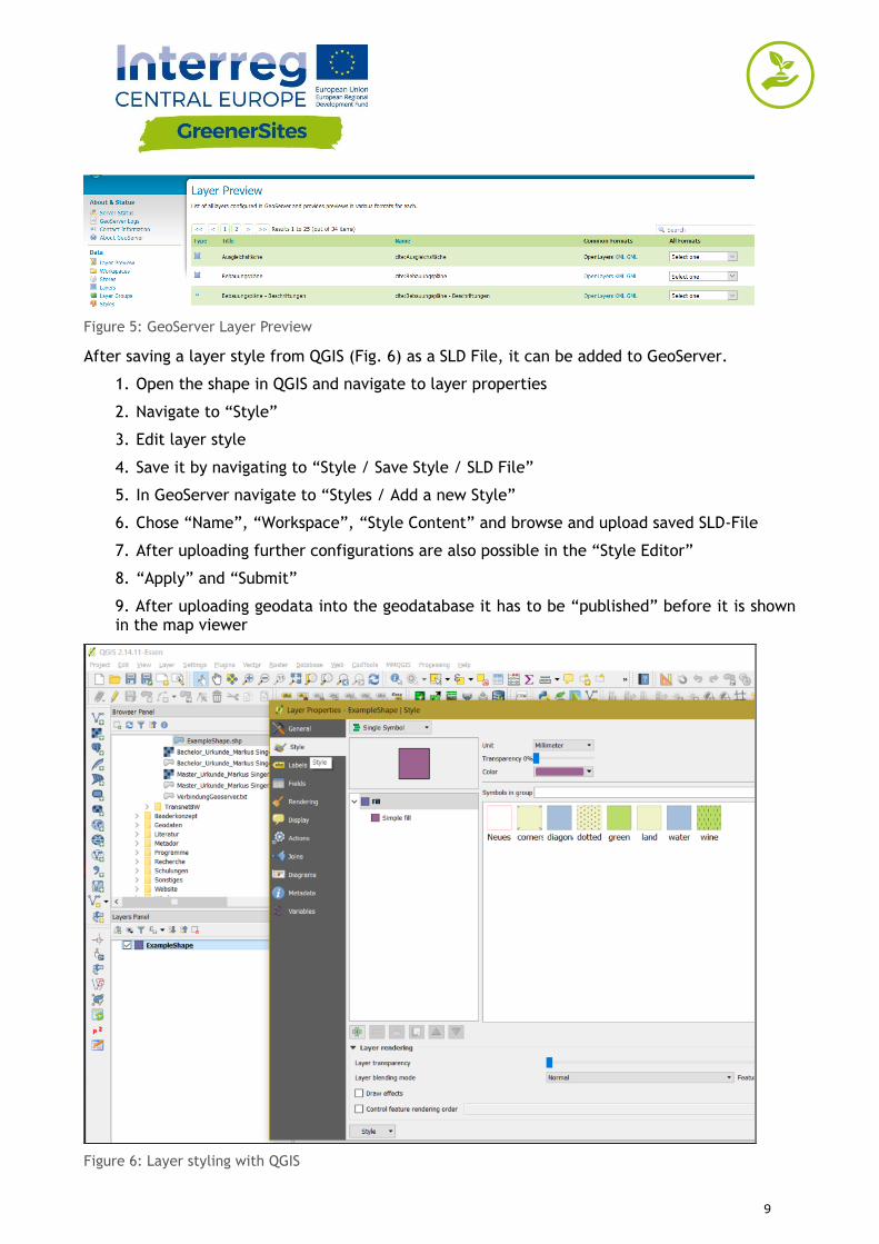
9
Figure 5: GeoServer Layer Preview
After saving a layer style from QGIS (Fig. 6) as a SLD File, it can be added to GeoServer.
1. Open the shape in QGIS and navigate to layer properties
2. Navigate to “Style”
3. Edit layer style
4. Save it by navigating to “Style / Save Style / SLD File”
5. In GeoServer navigate to “Styles / Add a new Style”
6. Chose “Name”, “Workspace”, “Style Content” and browse and upload saved SLD-File
7. After uploading further configurations are also possible in the “Style Editor”
8. “Apply” and “Submit”
9. After uploading geodata into the geodatabase it has to be “published” before it is shown in the map viewer
Figure 6: Layer styling with QGIS
10
Sustainable redevelopment of GreenerSites pilot brownfields in Functional Urban Areas
Former chemical plant “Zachem” in Bydgoszcz, Poland
FUA population: 785 000
FUA size: 3199 km2
Situation of brownfields:
In Poland there is no official catalog of contaminated areas, including brownfields. Such actions are not taken at national or regional level in contrast to policies in countries such as Italy or Germany. However, there are systems containing fragmentary inventory of contaminated areas. Unfortunately, these data are only available for selected administrative staff and do not represent the public domain.
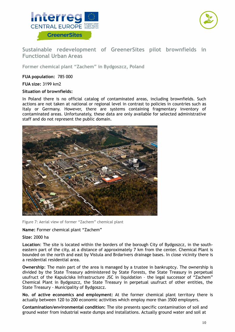
Figure 7: Aerial view of former “Zachem” chemical plant
Name: Former chemical plant “Zachem”
Size: 2000 ha
Location: The site is located within the borders of the borough City of Bydgoszcz, in the south-eastern part of the city, at a distance of approximately 7 km from the center. Chemical Plant is bounded on the north and east by Vistula and Brdarivers drainage bases. In close vicinity there is a residential residential area.
Ownership: The main part of the area is managed by a trustee in bankruptcy. The ownership is divided by the State Treasury administered by State Forests, the State Treasury in perpetual usufruct of the Kapuściska Infrastructure JSC in liquidation – the legal successor of “Zachem” Chemical Plant in Bydgoszcz, the State Treasury in perpetual usufruct of other entities, the State Treasury - Municipality of Bydgoszcz.
No. of active economics and employment: At the former chemical plant territory there is actually between 120 to 200 economic activities which employ more than 3500 employers.
Contamination/environmental condition: The site presents specific contamination of soil and ground water from industrial waste dumps and installations. Actually ground water and soil at
11
large part of formal “Zachem” plant is highly contaminated by organic pollutants (carcinogenic and mutagenic) with relatively high concentrations. Until now 27 supposed pollutants sources have been identified and 7 plumes of groundwater pollutants. Main organic contaminants are Cl-and Na+, inorganic contaminants: phenol, AOX substances, diphenylsulfone, hydroxybiphenyl, octylphenoland ethoxylatedoctylphenolesters and chlorinatedethenesand methanes. Further investigations are necessary for the area. Main challenges: The main requirements for future needs related to the planning and implementation of effective remediation include:
execution and current operation of groundwater monitoring network in order to gather reliable data for the optimal selection of techniques and methods of effective remediation including in particular the impact on local residents,
remediation project execution based on advanced numerical models,
raising funds for the often long-term remediation, where due to its high cost is necessary participation of the government at the level of voivodeship and even central,
to take effective remediation to bring its parameters to an acceptable level.
Planned pilot action:
The pilot action aims at assessing environmental and human risks associated with the ground and groundwater contamination of the former chemical factory. It is planned to install an innovative monitoring ground and groundwater system including series of the laboratory tests and hydrogeological modelling. Pilot activity will be supplemented by series of local trainings and stakeholders meetings that are necessary for long term remediation of the area.
Impact on the environment and human health (alternatively): In the immediate vicinity of the former “Zachem” Chemical Plant there are areas inhabited by the Bydgoszcz citizens, including the Emergency Housing Estate, Łęgnow, Brdyujście and towns Plątnowo and Otorowo. Any environmental pollution has always direct impact on the local community. It is associated with the migration of plumes of contaminated groundwater, contamination of new residential areas, inflow of contaminated water to farm wells and the potential gas exhalation in the river valleys. Citizens of the town Łęgnowo are subjected to the greatest threat, as they are exposed to direct contact with organic chemicals, often toxic and of carcinogenic and mutagenic character.
12
Former railway sleepers preservation plant in Solec Kujawski, Poland
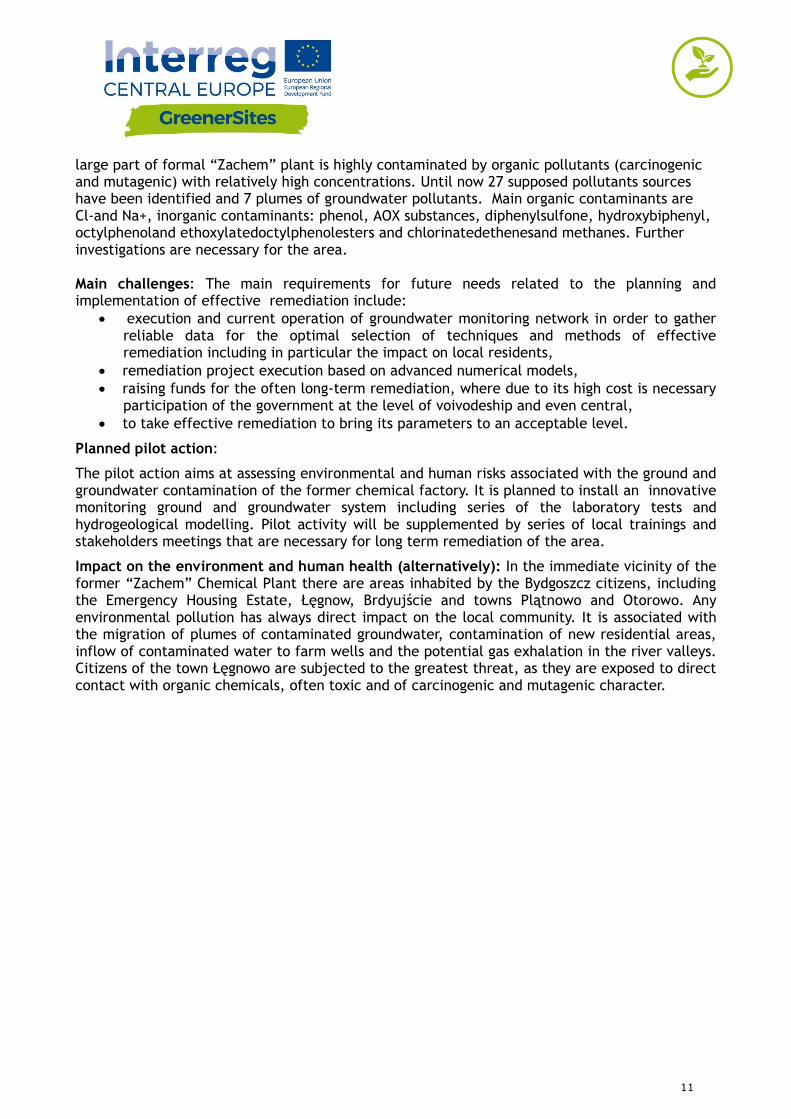
Figure 8: Aerial view of Former railway sleepers preservation plant area
Name: Former railway sleepers preservation plant.
Size: 16,44 ha.
Location: The area is located in the eastern part of Solec Kujawski, in the Kuyavian-Pomeranian voivodeship at 2 Kujawska Street, in the neighbourhood of a multifamily housing estate, ‘JuraPark’ entertainment and education park, objects of Sport and Recreation Centre with a swimming pool, sports and entertainment hall and sports stadium. Strategic position of the area in the central part of the town surrounded by streets and railway tracks.
Ownership: The land was purchased in 2008 by Municipality of Solec Kujawski.
No of active economics and employment: N/A.
Contamination/environmental condition: A major problem for the environment is poor quality of groundwater. Existing here earlier for decades hot spots created so-called secondary hot spots in the saturation zone, before they have been removed or significantly reduced. They cause the current long-term contamination of groundwater. As for the soil, after three years of remediation its quality has improved greatly. The hardest to eliminate organic compounds (PAHs) were greatly reduced. Currently the quality improvement is monitored – the bioremediation of soil and subsoil phase takes place.
Main challenges: Contamination such as creosote oil (impregnate used in railway sleepers) can diffuse deep into the aquifer and it causes permanent pollution of groundwater. Currently, it has been detected that at a depth of 16-20 metres below the ground level, the dense non-aqueous phase liquid (DNAPL), i.e. creosote oil, is very slowly migrating from the area of former contamination sources. Because this process has been ongoing for decades, the plume of concentrated pollutants has flown out of the brownfield area and threatens to degrade the areas designated for housing. Also, it pollutes strongly the groundwater flowing into the Vistula River - the main river in Poland, astride which city Solec Kujawski lies.
13
Planned pilot action: One of the tasks is the diagnosis of this specific contamination in waters, monitoring of changes in concentration, directions of migration, composition etc. and development of a method to stop and eliminate the threat. For this purpose, a network of test holes and a monitoring network have been expanded. Research is carried out using standard methods (analysis of water samples) and passive samplers - measurements are currently in progress.
Impact on the environment and human health: The plume of concentrated pollutants which have flown out of the brownfield area is a threat to the inhabitants living in the neighbourhood housing estate. Moreover, it strongly pollutes the groundwater flowing into the Vistula River, thus threatening the areas belonging to the European ecological network “Nature 2000”.
Best practices in different disciplines: In the period of 2013-2016 the area was subjected to remediation of soil and partially groundwater due to the work of co-financing from EU funds (Operational Programme Infrastructure and Environment). A conceptual design of an ‘in situ’ decontamination method was developed.
14
Former CHP plant in Radom, Poland
FUA population: 2.7 million people
FUA size: 2,730.23 km2
Situation of brownfields
In the Mazovia Region information on its post-industrial areas and environmental conditions is scattered, incomplete and fragmentary. It's also difficult to get reliable data on the degree of the given area degradation. There is lack of comprehensive information about environmental hazards of the degraded areas due to industry and utility categories for the future economic potentials. In the FUA Warsaw, Płock, Radom and Pionki there are identified brownfields, main environmental concerns are related to specific contamination of:
- air quality,
- quality of surface and ground water,
- soil quality,
- natural heritage and its potential impact,
- land consumption in urban areas.
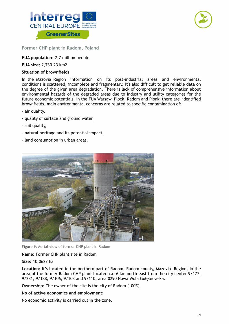
Figure 9: Aerial view of former CHP plant in Radom
Name: Former CHP plant site in Radom
Size: 10,0627 ha
Location: It’s located in the northern part of Radom, Radom county, Mazovia Region, in the area of the former Radom CHP plant located ca. 6 km north-east from the city center 9/177, 9/231, 9/188, 9/106, 9/103 and 9/110, area 0290 Nowa Wola Gołębiowska.
Ownership: The owner of the site is the city of Radom (100%)
No of active economics and employment:
No economic activity is carried out in the zone.
15
Contamination/environmental condition:
The analyzed site have data based on which it would be possible to assess the level of its degradation, as well as directions for further actions. In each section, surface soil samples were collected, from a depth of 0 - 0.25 m bgl. A comparison of the obtained test results with allowable concentrations determined in the a/m regulation indicates that the sum of C12 - C35 hydrocarbons (mineral oil fraction) and PAH (benzo(a)anthracene, benzo(a)pyrene, Benzo(b)fluoranthene) were exceeded in the sections 11, 12 and 14. The rest of samples from other sections did not indicate an exceeding of any of the tested parameters against threshold concentrations specified for soils of group I and result none of the tested parameters has been exceeded in the tested soil samples. Results of laboratory analyses of groundwater exceeding is allowed for the threshold calcium value when determining the quality class of groundwater at the measuring point.
Main challenges: A suitably prepared and executed process of preparing the site for investment (including the required remediation, recommended restoration with a dismantling of existing developments), coupled with an analysis of potential social and economic risks, should ensure the safety of future activities, both in the context of the development of the analyzed area, as well as of the people frequenting the area in relation to conducted business activity.
Planned action: For the area of the former CHP plant the study suggests the following recommendations for the plan:
enable investment activities, service and industrial areas and power plants on the plots adjacent areas by increasing the function of service and production,
realization of the objectives of the public in the field of construction of basic transport system (road a collective move to the western side of the line PKP)
revitalization of degraded brownfield and change of use of agricultural land for the purposes of building and service industry,
implementation of applicable laws on the protection of the environment,
intensification of investing selected areas (according to the findings SUiKZP)
improving the investment attractiveness of the city and create jobs by increasing the supply of land for production and service functions.
Impact on the environment and human health:
Due to the lack of data of impact on the environment and human health it is necessary to carry out tests to development on its post-industrial areas .
Best practices in different disciplines:
Post-industrial area management system introduced in Silesia (Śląsk) can be a good practice example. The Silesian Regional Assembly (Sejmik Województwa Śląskiego) adopted the Regional Assembly Post-industrial and Degraded Areas Transformation Act, no III/31/11/2008, on December, 17, 2008, dedicated to the regional database of post-industrial areas. The aim of the program is to create tools enabling the preliminary and full valorisation of areas and their classification as well as application of these tools for areas included in the regional base.
16
Porto Marghera Industrial area in Venice, Italy
FUA population: 855,696
FUA size: 2,472.91 km2
Situation of brownfields:
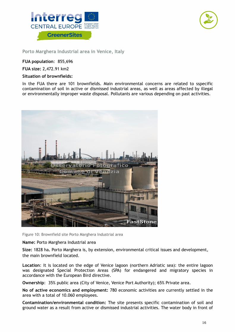
In the FUA there are 101 brownfields. Main environmental concerns are related to sspecific contamination of soil in active or dismissed industrial areas, as well as areas affected by illegal or environmentally improper waste disposal. Pollutants are various depending on past activities.
Figure 10: Brownfield site Porto Marghera Industrial area
Name: Porto Marghera Industrial area
Size: 1828 ha. Porto Marghera is, by extension, environmental critical issues and development,
the main brownfield located.
Location: It is located on the edge of Venice lagoon (northern Adriatic sea): the entire lagoon was designated Special Protection Areas (SPA) for endangered and migratory species in accordance with the European Bird directive.
Ownership: 35% public area (City of Venice, Venice Port Authority); 65% Private area.
No of active economics and employment: 780 economic activities are currently settled in the area with a total of 10.060 employees.
Contamination/environmental condition: The site presents specific contamination of soil and ground water as a result from active or dismissed industrial activities. The water body in front of
17
Porto Marghera should be considered in a poor ecological status. The status of contamination is known is for the 19% of the area but remediation procedures have not yet started. However, in circa 49% of the total area the remediation projects have been approved by relevant public authorities. Remediation procedures have been completed only in 241 ha (14%).
Main challenges: Porto Marghera is, by Law, since 1998 (Law n. 426/1998), a “Sito di Bonifica di Interesse Nazionale”, which means a remediation site of national interest because of its potential impact on the environment given its surface extension and risk posed by contaminants. In particular the second industrial area - the main brownfield - mainly hosting settlements related to the raw chemical industry, needs a deep requalification or a strong reconversion.
Planned pilot action: 3 different pilot actions will be implemented in the area by the respectively by the City of Venice, the Veneto Region and the North Adriatic Sea.
Port Authority
reviewing and speeding up the remediation procedures of the sites in order to enhance the industrial reuse of selected sites and definition of specific financial and fiscal instruments to attract new investments in the area;
setting up a system for monitoring the air quality in the sites subject to remediation and future reuse. The definition of a site specific soil-gas reference level will help to select adequate remediation procedures with a view to their functional reuse;
testing the capping method in a selected site which, thanks to a cost-effective investment and an environmental-friendly approach, could guarantee sustainable remediation of excavated material.
The industrial zone of Porto Marghera has been recently deemed by the Italian Government “a complex industrial crisis area”. This status increases and favours the reconversion of the whole area. In particular planned actions foresee:
reviewing and speeding up the remediation procedures of the sites in order to enhance the industrial reuse of selected sites;
completing some major infrastructural interventions aimed at improving the environmental conditions of the area;
expanding and enhancing the Porto Marghera Custom Free Zone to increase the competitiveness of the area;
supporting the industrial recovery of the area;
planning of fiscal and financial instruments to attract new private investments in the area.
Impact on the environment and human health: The presence of 9 factories that use dangerous substances still impacts on the population. According to a risk assessment document, shared between relevant actors and institutions, 3 areas were defined by a different level of risk.
Best practices in different disciplines:
Phytoremediation of 150 ha has been developed in the area to treat civil waste water in order to reuse it for industrial purposes.
Between 1993 and 2014 a sustainable regeneration process took place to develop the Science and Technology Park, called VEGA. This process depended on bioremediation (biopile), which, for that time, represented an innovative solution as the excavated soil, with amendment, formed into compost piles (a basic bio-pile system includes a treatment bed, an aeration system, an irrigation/nutrient system and a leachate
18
collection system. Moisture, heat, nutrients, oxygen, and pH are controlled to enhance biodegradation).
ENI, the greatest Italian oil and gas company which has been present in Porto Marghera since the twenties, converted a traditional oil refinery into a biorefinery, transforming organic raw materials into high-quality biofuels. The company invested €200 million to transform the petrochemical plant into an integrated green chemical hub with the aim to guarantee an economically sustainable future for the site and protect employment levels and at the same time ensure the environmental sustainability of the whole reconversion project.
An example of completed remediation works are those ones that allowed the redevelopment of a vast area in Venice-Porto Marghera, the so called Ex Alumix Area, which now is used as a port logistics area. The investment only for remediation consisted in 11.250.000 €.
19
Mlaka area in Rijeka, Croatia
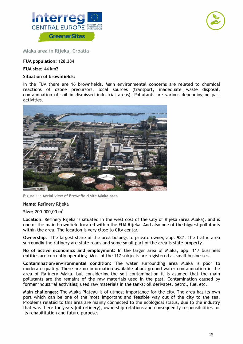
FUA population: 128,384
FUA size: 44 km2
Situation of brownfields:
In the FUA there are 16 brownfields. Main environmental concerns are related to chemical reactions of ozone precursors, local sources (transport, inadequate waste disposal, contamination of soil in dismissed industrial areas). Pollutants are various depending on past activities.
Figure 11: Aerial view of Brownfield site Mlaka area
Name: Refinery Rijeka
Size: 200.000,00 m2
Location: Refinery Rijeka is situated in the west cost of the City of Rijeka (area Mlaka), and is one of the main brownfield located within the FUA Rijeka. And also one of the biggest pollutants within the area. The location is very close to City centar.
Ownership: The largest share of the area belongs to private owner, app. 98%. The traffic area surroundig the rafinery are state roads and some small part of the area is state property.
No of active economics and employment: In the larger area of Mlaka, app. 117 bussiness entities are currently operating. Most of the 117 subjects are registered as small businesses.
Contamination/environmental condition: The water surrounding area Mlaka is poor to moderate quality. There are no information available about ground water contamination in the area of Rafinery Mlaka, but considering the soil contamination it is asumed that the main pollutants are the remains of the raw materials used in the past. Contamination caused by former industrial activities; used raw materials in the tanks; oil derivates, petrol, fuel etc.
Main challenges: The Mlaka Plateau is of utmost importance for the city. The area has its own port which can be one of the most important and feasible way out of the city to the sea. Problems related to this area are mainly connected to the ecological status, due to the industry that was there for years (oil refinery), ownership relations and consequently responsibilities for its rehabilitation and future purpose.

20
Planned pilot action: Fundamental research of soil, water and air pollution of the old industrial port Mlaka and study on future use of pilot area.
Impact on the environment and human health (alternatively): Refinery Mlaka is closed, so currently there are not any impacts on the environmental or human health.
Best practices in different disciplines:
An example of good practice was the former military base on Trsat, which was overhauled and completely restored to the University campus. This example and model could also be applicable to revitalization of Refinery Mlaka, of course, with all necessary tests, analyzes, elaborations etc.
21
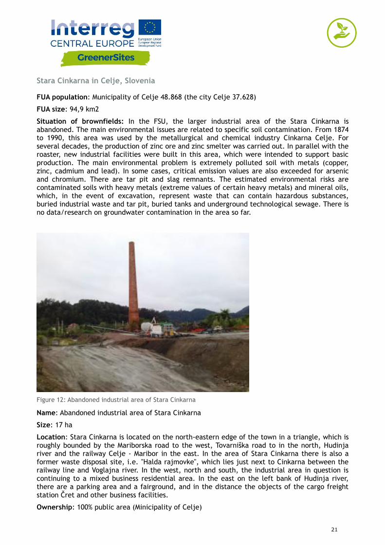
Stara Cinkarna in Celje, Slovenia
FUA population: Municipality of Celje 48.868 (the city Celje 37.628)
FUA size: 94,9 km2
Situation of brownfields: In the FSU, the larger industrial area of the Stara Cinkarna is abandoned. The main environmental issues are related to specific soil contamination. From 1874 to 1990, this area was used by the metallurgical and chemical industry Cinkarna Celje. For several decades, the production of zinc ore and zinc smelter was carried out. In parallel with the roaster, new industrial facilities were built in this area, which were intended to support basic production. The main environmental problem is extremely polluted soil with metals (copper, zinc, cadmium and lead). In some cases, critical emission values are also exceeded for arsenic and chromium. There are tar pit and slag remnants. The estimated environmental risks are contaminated soils with heavy metals (extreme values of certain heavy metals) and mineral oils, which, in the event of excavation, represent waste that can contain hazardous substances, buried industrial waste and tar pit, buried tanks and underground technological sewage. There is no data/research on groundwater contamination in the area so far.
Figure 12: Abandoned industrial area of Stara Cinkarna
Name: Abandoned industrial area of Stara Cinkarna
Size: 17 ha
Location: Stara Cinkarna is located on the north-eastern edge of the town in a triangle, which is roughly bounded by the Mariborska road to the west, Tovarniška road to in the north, Hudinja river and the railway Celje - Maribor in the east. In the area of Stara Cinkarna there is also a former waste disposal site, i.e. "Halda rajmovke", which lies just next to Cinkarna between the railway line and Voglajna river. In the west, north and south, the industrial area in question is continuing to a mixed business residential area. In the east on the left bank of Hudinja river, there are a parking area and a fairground, and in the distance the objects of the cargo freight station Čret and other business facilities.
Ownership: 100% public area (Minicipality of Celje)
22
No of active economics and employment: There are currently 25 companies operating in this area (Tehnopolis and others). There is no data on the number of employees in this area.
Contamination/environmental condition: In this area, the soil condition monitoring was carried out at 38 points (depth up to 25 cm, at two points up to 60 cm). Earth monitoring was also performed at a depth of 10 m (8 samples). Groundwater status was determined on 4 temporary wells. Sanation Land redevelopment procedures have not yet been approved by the Slovenian public authorities.
Main challenges: Existing unmanaged brownfield areas have more synergy-acting negative effects, such as the acquisition of investors, negative impacts on the quality of life, increased social conflicts, the concern of the population and increased pressure on the spread of settlement to agricultural areas. At the government level, the problem of solving degraded areas is not regulated by law yet. Current environmental protection legislation and spatial planning legislation do not define procedures and methodologies for managing abandoned degraded areas.
Planned pilot action: The Municipality of Celje has already set up a monitoring system to monitor the underground water in the area of Old Cinkarna. A detailed analysis of all pollutants in the pilot area is in process and will be concluded by the end of 2018. We plan to test the effectiveness of solidification method for remediation of the area of Old Cinkarna. Also, a protocol procedure of non-hazardous waste disposal will be made as part of GreenerSites project.
Impact on the environment and human health: There is no specific risk analysis of human health or the environment in the area. It is estimated that human health can be affected from the naked surfaces pollution of the soil dusting in the area and of the pollutants into groundwater.
Best practices in different disciplines: In the sanation restoring process of the old Cinkarna area, we propose the following approach:
- to perform a thorough investigation of the entire area and determine which parts of the land are so contaminated that they have the characteristics of hazardous waste. Special attention should be given to contamination with tar and mineral oils. On the basis of the obtained data on the state of the environment in the area the preparation of risk assessment is necessary to identify significant environmental and human health effects,
- to perform a detailed site investigation to identify the types, quantities and properties of waste, products and raw materials remaining in the area,
- to perform screening of the terrain to find out whether any waste is buried in the ground and determine possible remediation methods,
- to implement a screening of the terrain to determine if the cavern is in the ground and take this into account when planning further use of the space,
- to perform hydrogeological research in the area with the implementation of piezometers,
- to remove all hazardous waste remaining in the area,
- to implement remediation or remove the soil contaminated with tar,
- to implement remediation or remove the soil contaminated with mineral oils,
- to implement other necessary measures to protect the environment against pollution,
- to create the timeframe and priorities of the activities in the framework of rehabilitation and to choose various solutions.
23
Magdeburg-Rothensee in Magdeburg, Germany
FUA population: 700.000 inhabitants (2015)
FUA size: 5.571 km2
Situation of brownfields:
A total of 4.549 suspected contaminated sites officially confirmed by the environmental authority are located in the FUA Magdeburg (2016). 163 of these suspected contaminated sites are situated within the boundaries of the city of Magdeburg. Pollutants are various as a legacy of industrial, mining and military activities in the area.
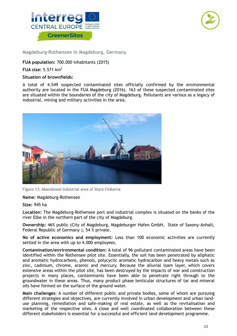
Figure 13: Abandoned industrial area of Stara Cinkarna
Name: Magdeburg-Rothensee
Size: 945 ha
Location: The Magdeburg-Rothensee port and industrial complex is situated on the banks of the river Elbe in the northern part of the city of Magdeburg.
Ownership: 46% public (City of Magdeburg, Magdeburger Hafen GmbH, State of Saxony-Anhalt, Federal Republic of Germany ), 54 % private.
No of active economics and employment: Less than 100 economic activities are currently settled in the area with up to 4.000 employees.
Contamination/environmental condition: A total of 96 pollutant contaminated areas have been identified within the Rothensee pilot site. Essentially, the soil has been penetrated by aliphatic and aromatic hydrocarbons, phenols, polycyclic aromatic hydrocarbon and heavy metals such as zinc, cadmium, chrome, arsenic and mercury. Because the alluvial loam layer, which covers extensive areas within the pilot site, has been destroyed by the impacts of war and construction projects in many places, contaminants have been able to penetrate right through to the groundwater in these areas. Thus, many product phase lenticular structures of tar and mineral oils have formed on the surface of the ground water.
Main challenges: A number of different public and private bodies, some of whom are pursuing different strategies and objectives, are currently involved in urban development and urban land-use planning, remediation and safe-making of real estate, as well as the revitalisation and marketing of the respective sites. A close and well coordinated collaboration between these different stakeholders is essential for a successful and efficient land development programme.
24
Planned pilot action: Web-based solutions offer a method of simplifying cross-disciplinary agreements and collaboration between the authorities and other stakeholders in the field of site remediation and brownfield redevelopment. In this way, data, plans and documents can be exchanged and shared in a rapid and uncomplicated manner. Information about the various sites and risk statuses can be accessed online at any time. Using the pilot site as an example, and within the framework of the GreenerSites project, a pilot action will be conducted implementing the Web GIS Tool for a sustainable collaboration between the participating local stakeholders.
Impact on the environment and human health: Extreme high contaminations of soil and groundwater at several spots within the Rothensee pilot site represent a considerable hazard to the environment and human health. Several hazard prevention measures as well as decontamination and remediation activities have been undertaken for the revitalisation of the area.
Best practices in different disciplines
Economic instruments
The Brownfield Authority Saxony-Anhalt is a specialised institution whose objective is the bundling of complex tasks associated with the elimination of legacy contaminated sites so as to provide targeted support for potential investors. As a matter of principle, the order in which the locations in question are processed depends upon the latent hazard potential. However, whenever investment measures are imminent, the processing of the affected area is prioritised, whereby the development plans for the site in question are coordinated with the potential investor. The objective is the short-term provision of cleaned up sites for economic utilisation.
Remediation techniques
In Magdeburg-Rothensee a ground water clean up project based on Air Sparging was completed in 2015. Air sparging is an in situ subsurface contaminant remediation technology that involves the injection of pressurised oxygen into contaminated ground water enabling the hydrocarbons to transform from a dissolved to a vaporous state. The air is then sent to vacuum extraction systems to remove the contaminants.
A system of steel piling walls and sealing walls has started in 2010 and is scheduled for completion in 2019. The seal wall system will prevent polluted groundwater from draining into the port and the River Elbe. In addition, action must be taken to dispose of or treat the residual contamination within the sealing wall system circulation system. To this end, an ENA-project (Enhanced Natural Attenuation) is planned whose objective is the in-situ biodegradation of heterocyclic hydrocarbons. The prerequisite safety system is scheduled for completion in 2018. The ENA-project is planned to operate from 2020 onwards.
25
Brownfield site Halle-Ammendorf in Halle (Saale), Germany
FUA population: 420,000 inhabitants
FUA size: 1,569 km2
Situation of brownfields:
In Halle area are located 9 brownfields sites. In Saalekreis area were located: 223 brownfields sites. That’s give total number of 232 brownfields sites in whole FUA area (officially confirmed by the environmental authority, as of November 2016). Main pollution source have been caused by lignite mining activities and the production of chemical products. It’s lead to create various contamination depending on past activities (e.g. chemical production, lignite mining, and machinery).
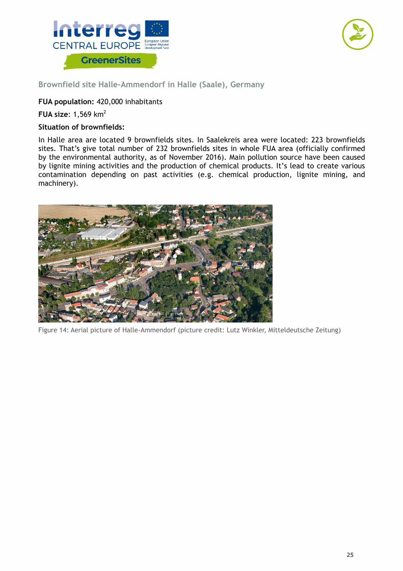
Figure 14: Aerial picture of Halle-Ammendorf (picture credit: Lutz Winkler, Mitteldeutsche Zeitung)
26
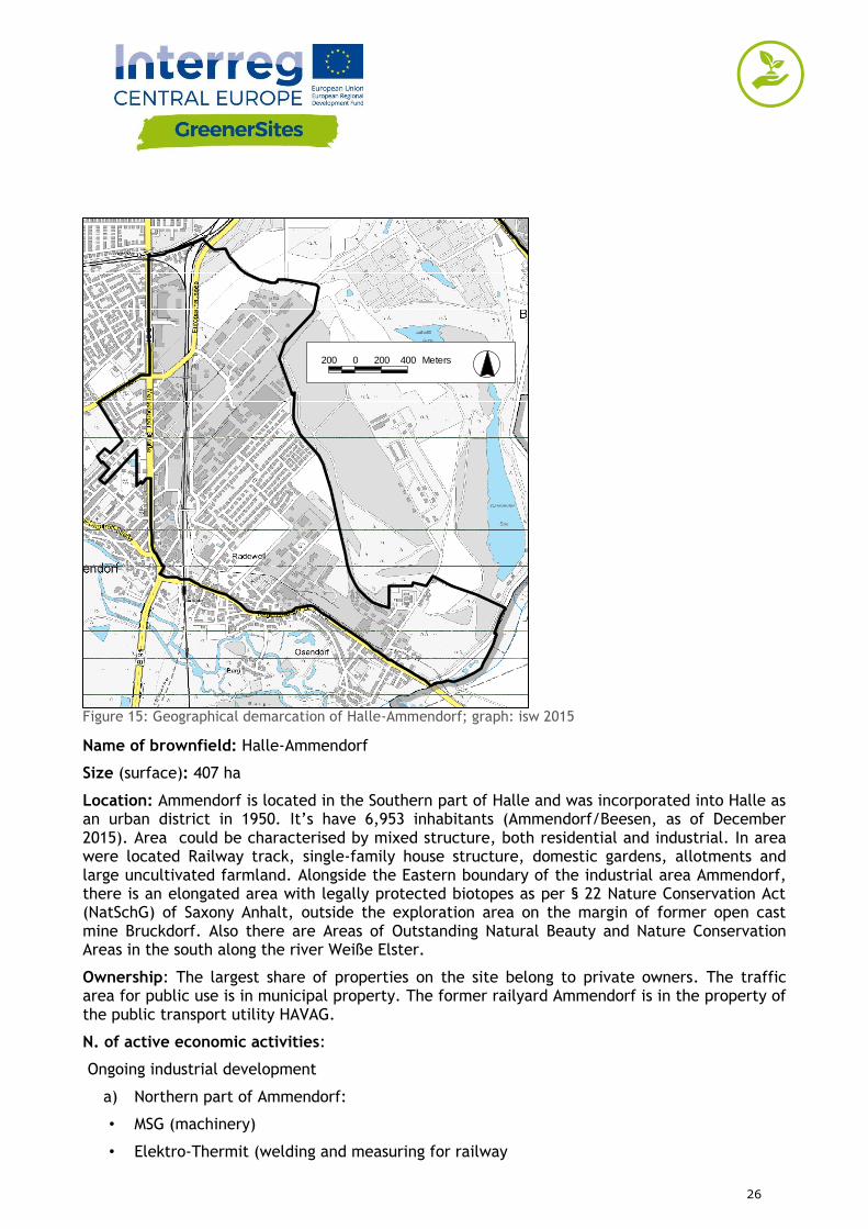
Figure 15: Geographical demarcation of Halle-Ammendorf; graph: isw 2015
Name of brownfield: Halle-Ammendorf
Size (surface): 407 ha
Location: Ammendorf is located in the Southern part of Halle and was incorporated into Halle as an urban district in 1950. It’s have 6,953 inhabitants (Ammendorf/Beesen, as of December 2015). Area could be characterised by mixed structure, both residential and industrial. In area were located Railway track, single-family house structure, domestic gardens, allotments and large uncultivated farmland. Alongside the Eastern boundary of the industrial area Ammendorf, there is an elongated area with legally protected biotopes as per § 22 Nature Conservation Act (NatSchG) of Saxony Anhalt, outside the exploration area on the margin of former open cast mine Bruckdorf. Also there are Areas of Outstanding Natural Beauty and Nature Conservation Areas in the south along the river Weiße Elster.
Ownership: The largest share of properties on the site belong to private owners. The traffic area for public use is in municipal property. The former railyard Ammendorf is in the property of the public transport utility HAVAG.
N. of active economic activities:
Ongoing industrial development
a) Northern part of Ammendorf:
• MSG (machinery)
• Elektro-Thermit (welding and measuring for railway
E-06E-14
E-11
E-02
200 0 200 400 Meters
27
• tracks)
• S.M.A. (metal technology)
• INDU LIGHT (light and ventilation systems)
b) Southern part of Ammendorf (Radewell / Osendorf):
• Tief- und Spezialbau Halle (underground engineering and special-purpose construction)
• TSR Recycling (disposal and waste management)
• Fehr Umwelt Ost (disposal and waste management)
• Metallbau Hofmann (metal construction)
• Chamber of crafts: new training centre
N. of workers: 630 employees (number refers to the Northern part of Ammendorf)
Contamination/environmental condition:
Air contamination. There have been noticed increased traffic-related pollution near Merseburger Street. The evaluation of the daily average of fine dust PM10 (limit value 50 µg/m³) in the area of Merseburger Street has been tending to decrease since 2011. Since 2012, the measured values (PM10: 23 to 12 µg/m³) have been clearly below the limit value of 50 µg/m³. In the exploration area, the annual average values for ozone are also clearly below the threshold (110 µg/m3).
Superficial Water contamination: Surface waters are not present in the exploration area. Approximately 2 km to the south, there is the course of the river Weiße Elster that flows in the Saale within the area of Beesen-Ammendorf. As stagnant surface waters, the open cast mine lakes „Osendorfer See“ and „Blaues Auge“ are to be mentioned that are in a distance of approx. 2 km to the East/Northeast.
Ground Water contamination: The recharge rate of groundwater for the exploration area is low due to the high degree of sealing. Due to the industrial development since the middle of the 19th century, high quantities of environmentally and especially water-hazardous substances were handled over a long time. Some rehabilitation works are still running or are at the planning stage. Due to the proximity to Nature Conservation Areas, the specific ground water contamination needs to be analysed for future settlements.
Soil contamination: Possible contamination caused by former industrial activities. Were observed high degree of sealing.
Main challenges: Main challenges is that contaminated brownfield sites are fragmented, mixed and parcelled, with diverse ownership structure. Other problem is limited availability and development of existing brownfields to meet current requirements (e.g. revitalisation, marketing, and expansion area for existing companies).
Planned pilot action: Institute for Structural Policy and Economic Development pilot action is about site analysis and site development of selected brownfields in Halle-Ammendorf. The main goal is to improve the site marketability, considering environmental aspects (e.g. reduction of space utilisation, unsealing). By categorising the sites according to specific criteria, positive and adverse determinants for site marketability become evident. Institute developed an action plan that was agreed on with the City of Halle. Currently, institute and City of Halle are working on data provision and criteria selection.
28
These materials are based on the analysis of current situation of brownfields in Functional Urban Areas.
Training materials were elaborated by partners of GreenerSites project:
GreenerSites Web-GIS Tool - Stefan Fina/Markus Singer and Philipp Zakrzewski
Former chemical plant “Zachem” in Bydgoszcz, Poland – Hanna Lewandowska, Mateusz Mazurkiewicz
Former railway sleepers preservation plant in Solec Kujawski, Poland – Justyna Jankowska, Katarzyna
Former CHP plant in Radom, Poland – Edyta Grocka
Porto Marghera Industrial in Venice, Italy – Alessia Porcu
Mlaka area in Rijeka, Croatia – Stefan Kacuba
Stara Cinkarna in Celje, Slovenia - Nina Mašat-Strle
Magdeburg-Rothensee in Magdeburg, Germany - Philip Zakrzewski
Brownfield site Halle-Ammendorf in Halle (Saale), Germany – Fiene Grieger
January 2018
These materials reflects the author’s views. The Programme bodies are not liable for any use that may
be made of the information contained therein.