Embed Size (px)
Citation preview
anchorage downtown comprehensive plan 73
TRANSPORTATION AND CIRCUL ATION5 transportation and circulation
OVERVIEW
Th is chapter addresses the complexity of Downtown’s transportation and circulation system as it relates to the vision for strengthening Downtown as a vital place in which to live, work, shop, conduct business, and support tourism.
Th e fi rst priority is to optimize multi-modal access to Downtown and create a place that is enjoyable and safe for walking, biking and using public transit. Th is goal will not only make possible the development density desired in Downtown, it will also enhance the retail experience, boost business, and make Downtown even more of a destination for cultural and social gatherings.
In addition to meeting the needs of pedestrians, bicyclists and transit riders, the transportation system must also serve local automobile and tour bus access and circulation while reducing the adverse impacts of through-traffi c and freight movement.
Th is chapter identifi es specifi c planning considerations, outlines transportation goals that support the plan’s vision, and recommends solutions to realize the full potential of Downtown Anchorage.
74 anchorage downtown comprehensive plan
TRANSPORTATION AND CIRCUL ATION
PLANNING CONSIDERATIONS
A number of factors in Downtown Anchorage currently infl uence transportation and circulation patterns. Th rough fi eld observations and reviews of previous transportation studies, several issues and challenges in the Downtown circulation network were identifi ed during the planning process.
Circulation
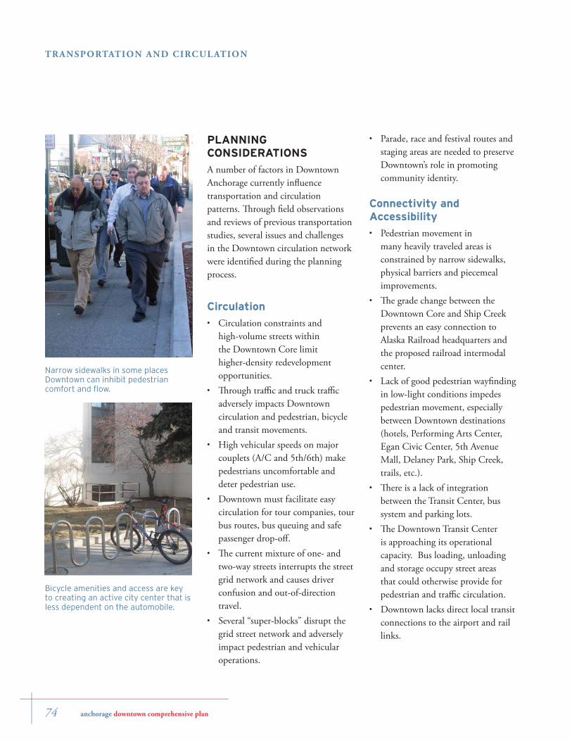
Circulation constraints and high-volume streets within the Downtown Core limit higher-density redevelopment opportunities.Th rough traffi c and truck traffi c adversely impacts Downtown circulation and pedestrian, bicycle and transit movements. High vehicular speeds on major couplets (A/C and 5th/6th) make pedestrians uncomfortable and deter pedestrian use.Downtown must facilitate easy circulation for tour companies, tour bus routes, bus queuing and safe passenger drop-off .Th e current mixture of one- and two-way streets interrupts the street grid network and causes driver confusion and out-of-direction travel. Several “super-blocks” disrupt the grid street network and adversely impact pedestrian and vehicular operations.
•
•
•
•
•
•
Parade, race and festival routes and staging areas are needed to preserve Downtown’s role in promoting community identity.
Connectivity and Accessibility
Pedestrian movement in many heavily traveled areas is constrained by narrow sidewalks, physical barriers and piecemeal improvements.Th e grade change between the Downtown Core and Ship Creek prevents an easy connection to Alaska Railroad headquarters and the proposed railroad intermodal center.Lack of good pedestrian wayfi nding in low-light conditions impedes pedestrian movement, especially between Downtown destinations (hotels, Performing Arts Center, Egan Civic Center, 5th Avenue Mall, Delaney Park, Ship Creek, trails, etc.).Th ere is a lack of integration between the Transit Center, bus system and parking lots.Th e Downtown Transit Center is approaching its operational capacity. Bus loading, unloading and storage occupy street areas that could otherwise provide for pedestrian and traffi c circulation.Downtown lacks direct local transit connections to the airport and rail links.
•
•
•
•
•
•
•
Narrow sidewalks in some places Downtown can inhibit pedestrian comfort and fl ow.
Bicycle amenities and access are key to creating an active city center that is less dependent on the automobile.
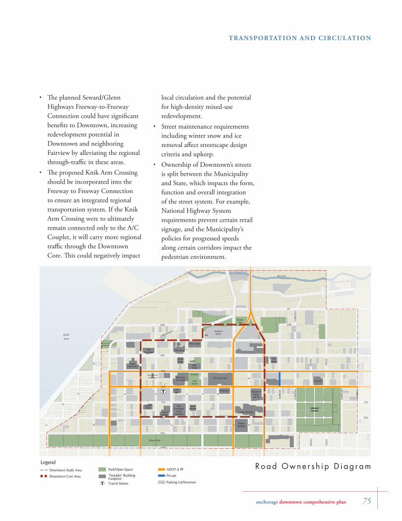
anchorage downtown comprehensive plan 75
TRANSPORTATION AND CIRCUL ATION
local circulation and the potential for high-density mixed-use redevelopment. Street maintenance requirements including winter snow and ice removal aff ect streetscape design criteria and upkeep.Ownership of Downtown’s streets is split between the Municipality and State, which impacts the form, function and overall integration of the street system. For example, National Highway System requirements prevent certain retail signage, and the Municipality’s policies for progressed speeds along certain corridors impact the pedestrian environment.
•
•
KnikArm
Delaney Park
Museum ofHistoryand Art
MemorialCemetery
5th Avenue Mall
Civic/Conv.Center
Center forPerforming
Arts
Quyana Park
CityHall
TownSquare
Tony Knowles Coastal Trail
4th Ave.Theater
ConventionCenter
ParkingStructure
MuseumExpansion
Mixed-UseParking Structure
CaptainCook Hotel
MarriottHotel
ConocoPhillips
StateBuilding
NewConvention
Center(underway)
WeekendMarket
I AL EK
9TH
G C
H
5TH
8TH
6TH
4TH
7TH
KnikArm
MemorialCemetery
Ship Creek
3RD
F
2ND
B
M
BARR
OW
CORD
OVA
EAG
LE
FAIR
BAN
KS
DEN
ALI
CHRISTENSEN
2ND
D
CORD
OVA
F
B
M
EAG
LE
DEN
ALI
1ST
10TH
GAM
BELL
8TH
7TH
N
P
O
Delaney Park
TownSquare
Kimballs
Museum ofHistoryand Art
5th Avenue Mall
EganCenter
PerformingArts Center
CityHall
Holy FamilyCathedral
StateCourthouse
4th AveTheater
Old FederalBuilding
FireStation
Hilton Hotel
Federal Building
Nordstrom's
FederalBuilding
CaptainCook Hotel
MarriottHotel
ConocoPhillips
AtwoodBuilding
Sheraton
MemorialCemetery
QuyanaPark
T
Ro ad Owne r s h i p D i ag r am"Notable" BuildingFootprint
Park/Open Space
LegendDowntown Study Area
Downtown Core Area
ADOT & PF
Parking Lot/Structure
Private
Transit StationT
Th e planned Seward/Glenn Highways Freeway-to-Freeway Connection could have signifi cant benefi ts to Downtown, increasing redevelopment potential in Downtown and neighboring Fairview by alleviating the regional through-traffi c in these areas.Th e proposed Knik Arm Crossing should be incorporated into the Freeway to Freeway Connection to ensure an integrated regional transportation system. If the Knik Arm Crossing were to ultimately remain connected only to the A/C Couplet, it will carry more regional traffi c through the Downtown Core. Th is could negatively impact
•
•
76 anchorage downtown comprehensive plan
TRANSPORTATION AND CIRCUL ATION
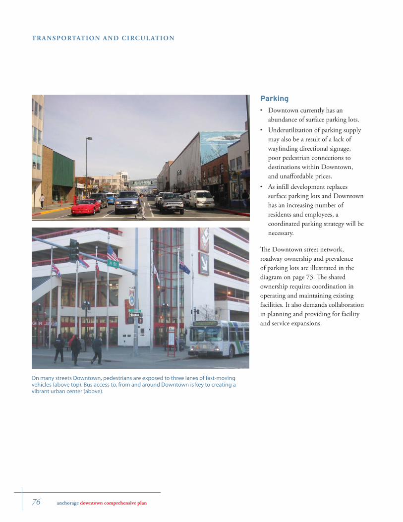
Parking
Downtown currently has an abundance of surface parking lots.Underutilization of parking supply may also be a result of a lack of wayfi nding directional signage, poor pedestrian connections to destinations within Downtown, and unaff ordable prices.As infi ll development replaces surface parking lots and Downtown has an increasing number of residents and employees, a coordinated parking strategy will be necessary.
Th e Downtown street network, roadway ownership and prevalence of parking lots are illustrated in the diagram on page 73. Th e shared ownership requires coordination in operating and maintaining existing facilities. It also demands collaboration in planning and providing for facility and service expansions.
•
•
•
On many streets Downtown, pedestrians are exposed to three lanes of fast-moving vehicles (above top). Bus access to, from and around Downtown is key to creating a vibrant urban center (above).
anchorage downtown comprehensive plan 77
TRANSPORTATION AND CIRCUL ATION
TRANSPORTATION AND CIRCULATION GOALS
Th e Downtown transportation system must support the Downtown vision and accomplish many goals at once. Th e goals on the opposite page articulate the way in which future transportation should provide access to and within Downtown. Th ese goals provide a framework for analyzing potential transportation improvements in Downtown Anchorage.
Promote and support walking and transit as the primary circulation modes within the Downtown Core
Improve pedestrian and bicycle safety, comfort, and mobility and minimize barriers to walking. Route buses such that transit can be used as a natural extension of the Downtown walk trip.
Provide access to Downtown via multiple modes of transportation
Downtown should be accessible to pedestrians, bicyclists, public transit riders and motorists for a wide variety of trips, including employment, education, shopping, recreation, and tourism. Improve transit routing to maximize effi ciency and the number of destinations served.
Provide convenient public parking locations and wayfinding
Manage and market parking in Downtown to allow convenient access to destinations and seamlessly connect parking to pedestrian and transit systems.The Downtown transportation
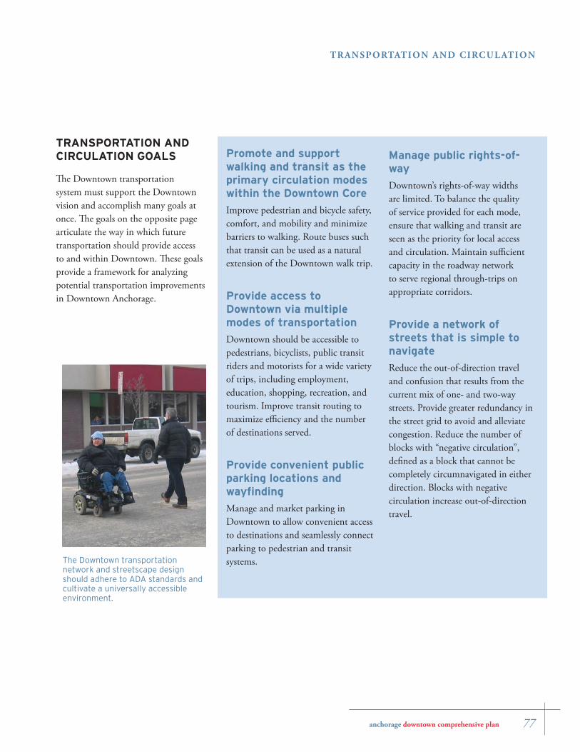
network and streetscape design should adhere to ADA standards and cultivate a universally accessible environment.
Manage public rights-of-way
Downtown’s rights-of-way widths are limited. To balance the quality of service provided for each mode, ensure that walking and transit are seen as the priority for local access and circulation. Maintain suffi cient capacity in the roadway network to serve regional through-trips on appropriate corridors.
Provide a network of streets that is simple to navigate
Reduce the out-of-direction travel and confusion that results from the current mix of one- and two-way streets. Provide greater redundancy in the street grid to avoid and alleviate congestion. Reduce the number of blocks with “negative circulation”, defi ned as a block that cannot be completely circumnavigated in either direction. Blocks with negative circulation increase out-of-direction travel.
78 anchorage downtown comprehensive plan
TRANSPORTATION AND CIRCUL ATION
A number of key recommendations will transform the nature of the city center’s transportation network and, in turn, the entire Downtown environment. All recommendations adhere to the goals set forth at the beginning of the chapter; they must be particularly sensitive to the fi rst two goals.
Th e specifi c recommendations in this section focus on the following topics:
Street ConversionsPedestrian & Bicycle ImprovementsTransit System ImprovementsCoordinated Parking Management ProgramTour Bus OperationsPhasing of Improvements
Th e changes must be carefully phased over time to maintain appropriate levels of service for users of the multi-modal transportation system. See Appendix B: Transportation Recommendations Memorandum for detailed technical analysis that supports these recommendations.
1. Street Conversions
Automobiles currently are the primary mode for access to Downtown Anchorage. While the Downtown Comprehensive Plan will improve access for other modes, automobiles are likely to remain the primary access mode for the foreseeable future.
•
•
•
•
•
•
In addition, the freight movements that travel through Downtown benefi t the regional economy and must be accommodated.
To address these issues, the planning team evaluated the existing street network and identifi ed weaknesses (listed on page 72) that would need to be addressed to improve circulation and support successful redevelopment of Downtown. Th e team used a transportation network modeling analysis to develop and evaluate 10 alternative scenarios for potential circulation systems for Downtown. Th ese scenarios tested the impact of changing the directionality and/or functional classifi cations of various streets in Downtown. Each scenario was evaluated based on its likely impact on: compatibility with land use and redevelopment goals; a quality pedestrian environment; regional through-trips; local traffi c circulation; freight mobility; transit access; tour bus operations; and construction feasibility. Th e results are documented in Appendix D, Anchorage Downtown Transportation Analysis
As a result of the transportation analysis, a combination of key street conversions are recommended. Th ese appear in the diagram on the opposite page and are described in the following pages. Some of the recommended street conversions can occur in the near term (9th Avenue, D Street, F Street), while others are dependent on unrelated improvements that must occur fi rst (5th Avenue and 3rd Avenue).
Recommendations
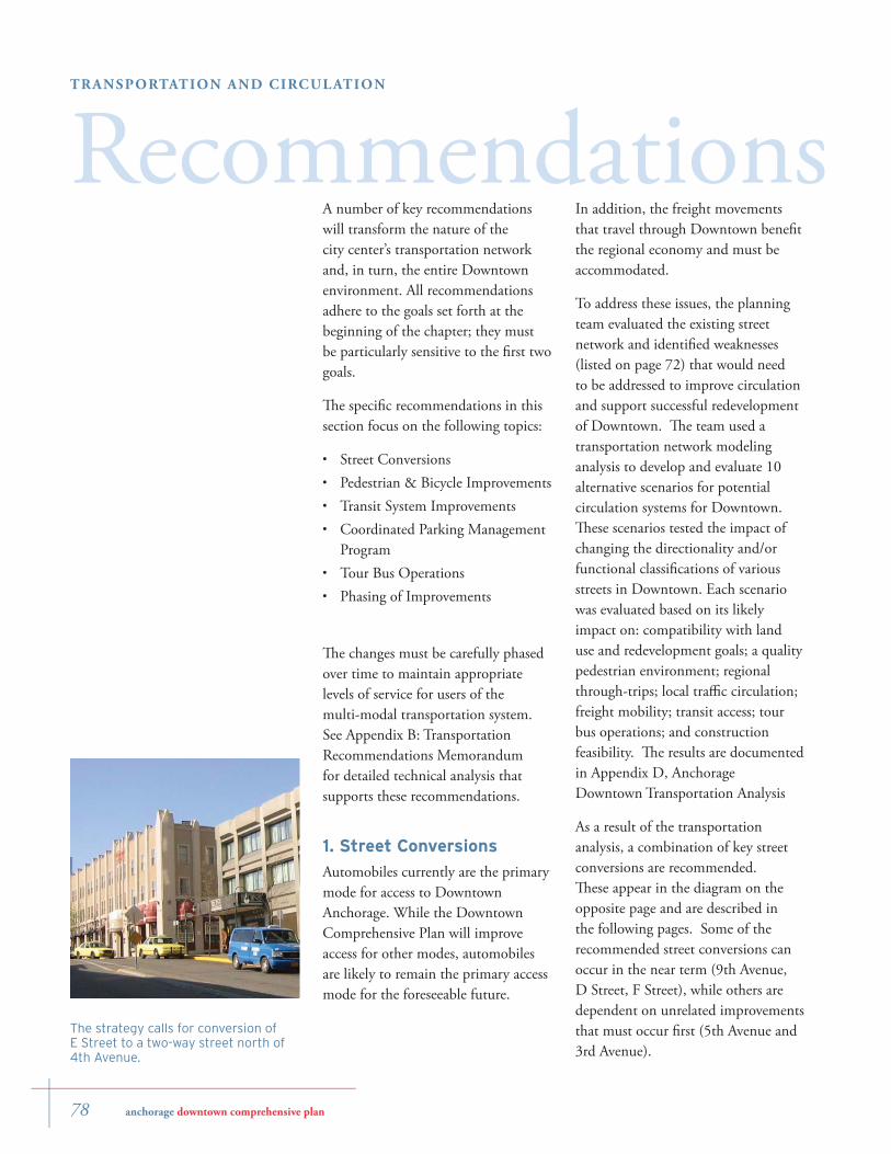
The strategy calls for conversion of E Street to a two-way street north of 4th Avenue.
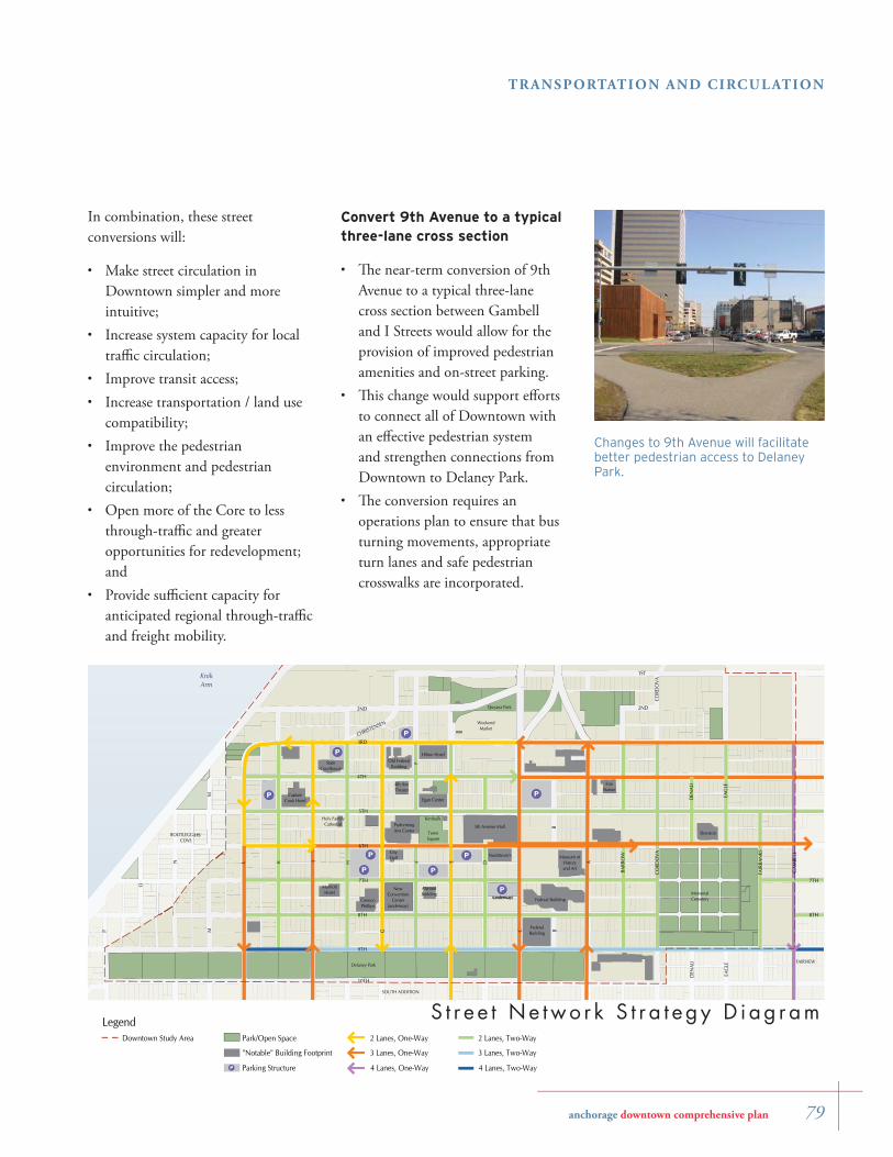
anchorage downtown comprehensive plan 79
TRANSPORTATION AND CIRCUL ATION
In combination, these street conversions will:
Make street circulation in Downtown simpler and more intuitive;Increase system capacity for local traffi c circulation;Improve transit access;Increase transportation / land use compatibility;Improve the pedestrian environment and pedestrian circulation; Open more of the Core to less through-traffi c and greater opportunities for redevelopment; and Provide suffi cient capacity for anticipated regional through-traffi c and freight mobility.
•
•
•
•
•
•
•
Convert 9th Avenue to a typical three-lane cross section
Th e near-term conversion of 9th Avenue to a typical three-lane cross section between Gambell and I Streets would allow for the provision of improved pedestrian amenities and on-street parking. Th is change would support eff orts to connect all of Downtown with an eff ective pedestrian system and strengthen connections from Downtown to Delaney Park.Th e conversion requires an operations plan to ensure that bus turning movements, appropriate turn lanes and safe pedestrian crosswalks are incorporated.
•
•
•
P(underway)
NewConvention
Center(underway)
P(underway)
NewConvention
Center(underway)
P
P
P
P
P
P
P
I AL EK
9TH
G C
H
5TH
8TH
6TH
4TH
7TH
3RD
F
2ND
B
M
BARR
OW
CORD
OVA
EAG
LE
FAIR
BAN
KS
DEN
ALI
CHRISTENSEN
2ND
D
CORD
OVA
F
B
M
EAG
LE
DEN
ALI
1ST
10TH
GAM
BELL
8TH
7TH
N
P
O
KnikArm
Delaney Park
Museum ofHistoryand Art
MemorialCemetery
5th Avenue Mall
Quyana Park
CityHall
TownSquare
CaptainCook Hotel
MarriottHotel
ConocoPhillips
AtwoodBuilding
SOUTH ADDITION
FAIRVIEW
BOOTLEGGERS'COVE
FireStation
Sheraton
WeekendMarket
PerformingArts Center
P
Holy FamilyCathedral
StateCourthouse
4th AveTheater
Old FederalBuilding
Hilton Hotel
Kimballs
Federal Building
Nordstrom's
FederalBuilding
Egan Center
LegendDowntown Study Area
4 Lanes, One-Way
3 Lanes, One-Way
2 Lanes, One-Way
4 Lanes, Two-Way
3 Lanes, Two-Way
2 Lanes, Two-WayPark/Open Space
"Notable" Building Footprint
Parking StructureP
S t r e e t Ne two r k S t r a t e g y D i ag r am
Changes to 9th Avenue will facilitate better pedestrian access to Delaney Park.
80 anchorage downtown comprehensive plan
TRANSPORTATION AND CIRCUL ATION
Travel speeds on 3rd Avenue should be managed to provide an attractive pedestrian environment, particularly west of C Street. A progressed speed of 20 MPH or less is recommended.Phase out West 3rd Avenue and L Street as a through-truck route, in conjunction with improvements to the existing street network outside the Downtown area which make other truck routes more feasible and attractive in terms of travel time, traffi c fl ow, turning movements and safety. After such phase-out, truck traffi c on West 3rd Avenue should be limited to local access only. In conjunction with the planned conversion of 3rd Avenue, reconfi gure the intersection of 4th Avenue and C Street to allow for safer and more effi cient eastbound truck turning movements and to preserve an outbound truck route to Gambell Street and the Glenn Highway.In conjunction with implementation of the Freeway-to-Freeway project, the Municipality should complete a 3rd Avenue One-Way Traffi c and Pedestrian Safety Implementation Plan that addresses:
Mitigation measures for bus loading, taxi queuing, auto parking and general impacts on business.
•
•
•
•
-
Convert D Street and F Street to two-way traffi c
Th e near-term conversion of D and F Streets to two-way traffi c would improve traffi c circulation in part by reducing driver confusion and out-of direction travel.On-street parking should be maintained and expanded wherever possible.
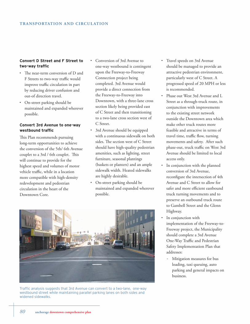
Convert 3rd Avenue to one-way westbound traffi c
Th is Plan recommends pursuing long-term opportunities to achieve the conversion of the 5th/ 6th Avenue couplet to a 3rd / 6th couplet. Th is will continue to provide for the highest speed and volumes of motor vehicle traffi c, while in a location more compatible with high-density redevelopment and pedestrian circulation in the heart of the Downtown Core.
•
•
Conversion of 3rd Avenue to one-way westbound is contingent upon the Freeway-to-Freeway Connection project being completed. 3rd Avenue would provide a direct connection from the Freeway-to-Freeway into Downtown, with a three-lane cross section likely being provided east of C Street and then transitioning to a two-lane cross section west of C Street.3rd Avenue should be equipped with a continuous sidewalk on both sides. Th e section west of C Street should have high-quality pedestrian amenities, such as lighting, street furniture, seasonal plantings (baskets or planters) and an ample sidewalk width. Heated sidewalks are highly desirable.On-street parking should be maintained and expanded wherever possible.
•
•
•
Traffi c analysis suggests that 3rd Avenue can convert to a two-lane, one-way westbound street while maintaining parallel parking lanes on both sides and widened sidewalks.
anchorage downtown comprehensive plan 81
TRANSPORTATION AND CIRCUL ATION
Downtown tour bus access routes and safe drop-off and pick-up sites.Pedestrian safety. Reducing routing of Downtown through-traffi c movement. Effi cient routing of downtown- local traffi c movement. Effi cient truck routing to ensure truck services are not negatively impacted.Impacts on 3rd Avenue businesses to ensure that the conversion strengthens business.
-
-
-
-
-
-
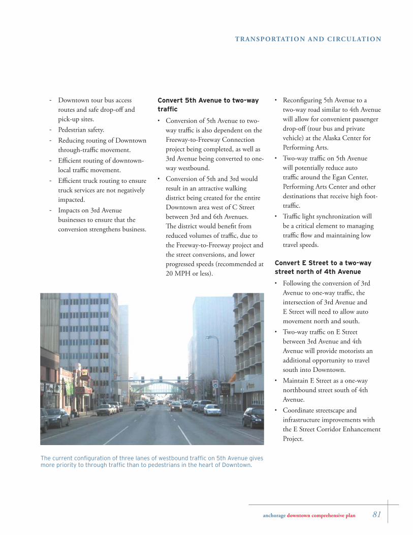
The current confi guration of three lanes of westbound traffi c on 5th Avenue gives more priority to through traffi c than to pedestrians in the heart of Downtown.
Convert 5th Avenue to two-way traffi c
Conversion of 5th Avenue to two-way traffi c is also dependent on the Freeway-to-Freeway Connection project being completed, as well as 3rd Avenue being converted to one-way westbound.Conversion of 5th and 3rd would result in an attractive walking district being created for the entire Downtown area west of C Street between 3rd and 6th Avenues. Th e district would benefi t from reduced volumes of traffi c, due to the Freeway-to-Freeway project and the street conversions, and lower progressed speeds (recommended at 20 MPH or less).
•
•
Reconfi guring 5th Avenue to a two-way road similar to 4th Avenue will allow for convenient passenger drop-off (tour bus and private vehicle) at the Alaska Center for Performing Arts.Two-way traffi c on 5th Avenue will potentially reduce auto traffi c around the Egan Center, Performing Arts Center and other destinations that receive high foot-traffi c.Traffi c light synchronization will be a critical element to managing traffi c fl ow and maintaining low travel speeds.
Convert E Street to a two-way street north of 4th Avenue
Following the conversion of 3rd Avenue to one-way traffi c, the intersection of 3rd Avenue and E Street will need to allow auto movement north and south.Two-way traffi c on E Street between 3rd Avenue and 4th Avenue will provide motorists an additional opportunity to travel south into Downtown.Maintain E Street as a one-way northbound street south of 4th Avenue.Coordinate streetscape and infrastructure improvements with the E Street Corridor Enhancement Project.
•
•
•
•
•
•
•
82 anchorage downtown comprehensive plan
TRANSPORTATION AND CIRCUL ATION
2. Street Typology
Functional classifi cations for streets have historically been based on the movement of motor vehicles. Consideration for adjacent land uses has been minimal in the functional classifi cations. Th e Anchorage Long-range Transportation Plan (LRTP) adopted in 2005 recognized the need for a more balanced street classifi cation system that emphasizes adjacent land uses such as unique mixed-use environments like Downtown, and considers other transportation types, including walking, bicycling and transit.
Th e LRTP identifi ed several street typologies to augment traditional classifi cations like arterial and collector. Each street typology prioritizes various design elements (sidewalks, on-street parking, lane widths, etc.) by looking at factors related to both the adjacent land uses and the functional classifi cation. Th e LRTP recommends that a determination of applicable street typology be established through municipal planning prior to future individual street improvement projects.
General concepts for three possible Downtown street typologies are identifi ed for consideration. Th ese concepts derive from the LRTP, the Downtown Core Streets Streetscape Plan, the Downtown Districts Diagram, Street Network Strategy Diagram, Pedestrian and Bicycle Diagram and other transportation and circulation strategies of this Plan.
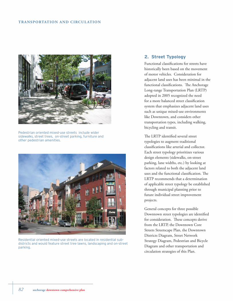
Residential oriented mixed-use streets are located in residential sub-districts and would feature street tree lawns, landscaping and on-street parking.
Pedestrian oriented mixed-use streets include wider sidewalks, street trees, on-street parking, furniture and other pedestrian amenities.
anchorage downtown comprehensive plan 83
TRANSPORTATION AND CIRCUL ATION
Th ese general concepts could be considered for possible further development and application as part of the public process to update the Downtown land use code. Because it is important that land uses interface with the adjacent streetscape in a downtown environment, street typologies can provide useful guidance for how future on-site property development relates to the type of adjoining street. For example, there could be extra incentives for buildings on a pedestrian-oriented mixed-use street to have more frequent entrances, windows and active ground-fl oor uses.
Th e general concepts for street typologies that could be considered include:
Mixed-use street: Most streets in Downtown tend to fi t the LRTP description for mixed-use streets. Mixed-use streets are located in areas characterized by a mix of high-intensity commercial, retail and residential areas with substantial pedestrian activities. Mixed-use streets emphasize pedestrian, bicycle and transit improvements, and frequently provide on-street parking and wider sidewalks, depending on the street’s functional designation and the intensity of abutting land uses. Pedestrian oriented mixed-use street: Th e mixed use street typology can be further refi ned to emphasize the streets of highest pedestrian use. Th ese streets would feature
•
•
the widest sidewalks, with an unobstructed clear width of at least 8-12 feet where possible, as well as curb-bulb-outs, raised intersections, and other pedestrian amenities where warranted by adjacent activities and where right-of-way and resources allow.Residential oriented mixed-use street: Th e residential oriented mixed use street is based on the LRTP mixed-use and residential streets typologies, and follows on the Downtown Plan’s proposed residential oriented sub-districts and urban design guidelines. Th ese streets would feature on-street parking and tree lawns between the sidewalk and street curb. Landscaping and front porches between residential buildings and the street would be encouraged.
•
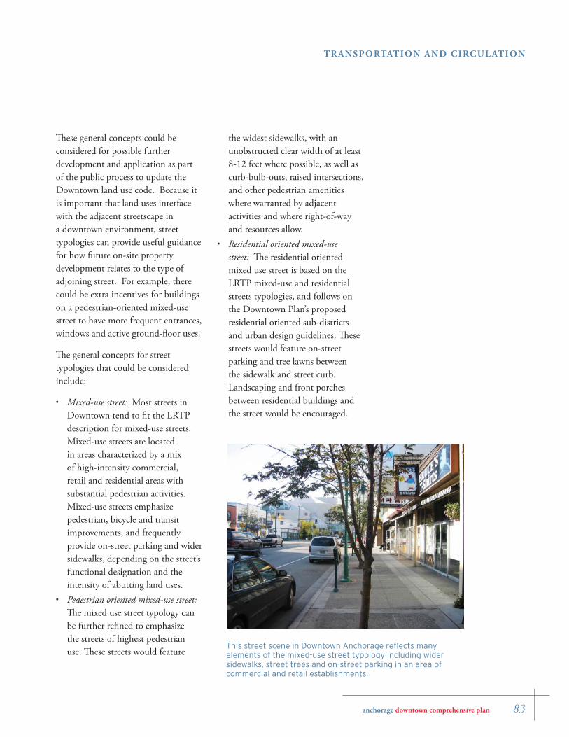
This street scene in Downtown Anchorage refl ects many elements of the mixed-use street typology including wider sidewalks, street trees and on-street parking in an area of commercial and retail establishments.
84 anchorage downtown comprehensive plan
TRANSPORTATION AND CIRCUL ATION
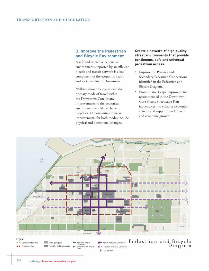
3. Improve the Pedestrian and Bicycle Environment
A safe and attractive pedestrian environment supported by an effi cient bicycle and transit network is a key component of the economic health and social vitality of Downtown.
Walking should be considered the primary mode of travel within the Downtown Core. Many improvements to the pedestrian environment would also benefi t bicyclists. Opportunities to make improvements for both modes include physical and operational changes.
T
T
I AL EK
9TH
G C
H
5TH
8TH
6TH
4TH
7TH
3RD
F
2ND
B
M
BARR
OW
CORD
OVA
EAG
LE
FAIR
BAN
KS
DEN
ALI
CHRISTENSEN
2ND
D
CORD
OVA
F
B
M
EAG
LE
DEN
ALI
1ST
10TH
GAM
BELL
HYD
ER
8TH
7TH
N
P
O
KnikArm
Delaney Park
Museum ofHistoryand Art
MemorialCemetery
5th Avenue Mall
CityHall
TownSquare
Tony
Know
lesCoa
stal T
rail
Ship Creek
CaptainCook Hotel
MarriottHotel
ConocoPhillips
AtwoodBuilding
SOUTH ADDITION
FAIRVIEW
BOOTLEGGERS'COVE
FireStation
Sheraton
WeekendMarket
PerformingArts Center
QuyanaPark
NewConvention
Center(underway)
Holy FamilyCathedral
StateCourthouse
4th AveTheater
Old FederalBuilding
Hilton Hotel
Kimballs
Federal Building
Nordstrom's
FederalBuilding
Egan Center
P e d eLegend
Transit StationT
Downtown Study Area Park/Open Space
Downtown Core "Notable" Building Footprint
On-Street BicycleConnectionPedestrian and BicycleTrail
Primary Pedestrian Connection
Secondary Pedestrian Connection
P ede s t r i a n a nd B i c y c l e D i ag r am
Create a network of high quality street environments that provide continuous, safe and universal pedestrian access.
Improve the Primary and Secondary Pedestrian Connections identifi ed in the Pedestrian and Bicycle Diagram.Promote streetscape improvements recommended in the Downtown Core Streets Streetscape Plan (appendices), to enhance pedestrian activity and support development and economic growth.
•
•
anchorage downtown comprehensive plan 85
TRANSPORTATION AND CIRCUL ATION
Enhance pedestrian crossings for continuity of access around Downtown. Install safe crossings across the A and C, 5th and 6th and I and L couplets.Calm traffi c on the A/C Couplet at key intersections as it passes through Downtown.
Connect regional bicycle and pedestrian trails into Downtown.
Improve the Pedestrian and Bicycle Trails and On-street Bicycle Connections identifi ed on the Pedestrian and Bicycle Diagram.Link Anchorage’s trails system into Downtown’s Pedestrian Connections to integrate non-vehicular circulation throughout Downtown. Directly link pedestrians and bicyclists to Downtown’s transit stations, parks and open spaces, cultural sites, facilities and neighborhoods.Ensure that safe, identifi able bicycle routes are prioritized. A bicycle lane should be designated as part of the 5th Avenue street conversion. Rights-of-way such as E and G that cannot accommodate a separate bicycle lane should include traffi c calming and bicycle amenities.
•
•
•
•
•
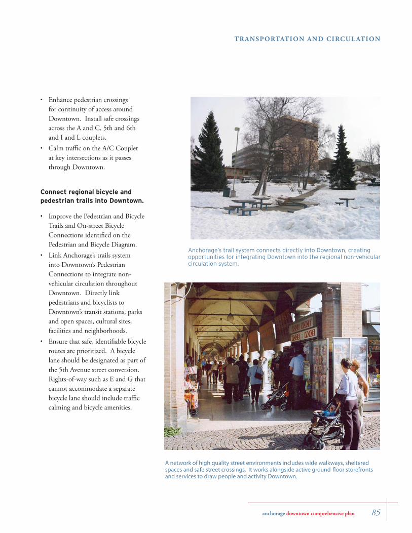
A network of high quality street environments includes wide walkways, sheltered spaces and safe street crossings. It works alongside active ground-fl oor storefronts and services to draw people and activity Downtown.
Anchorage’s trail system connects directly into Downtown, creating opportunities for integrating Downtown into the regional non-vehicular circulation system.
86 anchorage downtown comprehensive plan
TRANSPORTATION AND CIRCUL ATION
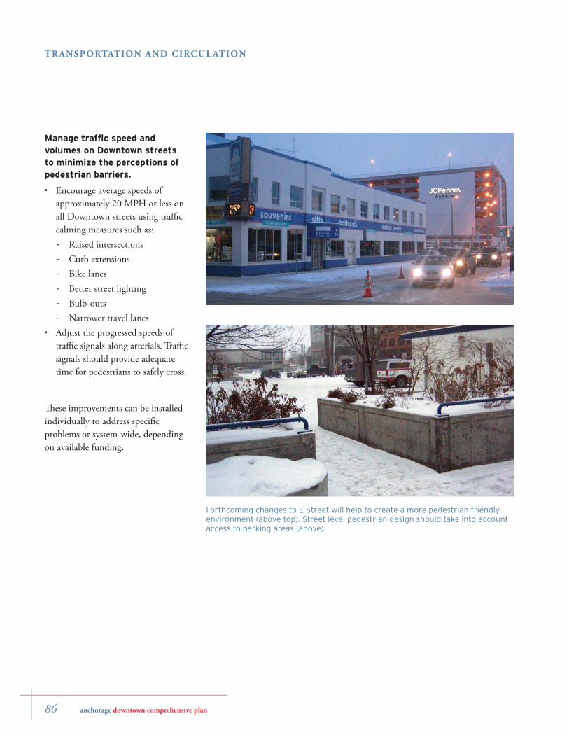
Forthcoming changes to E Street will help to create a more pedestrian friendly environment (above top). Street level pedestrian design should take into account access to parking areas (above).
Manage traffi c speed and volumes on Downtown streets to minimize the perceptions of pedestrian barriers.
Encourage average speeds of approximately 20 MPH or less on all Downtown streets using traffi c calming measures such as:
Raised intersectionsCurb extensionsBike lanesBetter street lightingBulb-outsNarrower travel lanes
Adjust the progressed speeds of traffi c signals along arterials. Traffi c signals should provide adequate time for pedestrians to safely cross.
Th ese improvements can be installed individually to address specifi c problems or system-wide, depending on available funding.
•
-
-
-
-
-
-
•
anchorage downtown comprehensive plan 87
TRANSPORTATION AND CIRCUL ATION
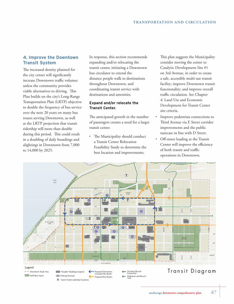
4. Improve the Downtown Transit System
Th e increased density planned for the city center will signifi cantly increase Downtown traffi c volumes unless the community provides viable alternatives to driving. Th is Plan builds on the city’s Long-Range Transportation Plan (LRTP) objective to double the frequency of bus service over the next 20 years on many bus routes serving Downtown, as well as the LRTP projection that transit ridership will more than double during this period. Th is could result in a doubling of daily boardings and alightings in Downtown from 7,000 to 14,000 by 2025.
P
P
P
P
P
P
P
P(underway)
T
T
T
I AL EK
9TH
G C
H
5TH
8TH
6TH
4TH
7TH
3RD
F
2ND
B
M
BARR
OW
CORD
OVA
EAG
LE
FAIR
BAN
KS
DEN
ALI
CHRISTENSEN
2ND
D
CORD
OVA
F
B
M
EAG
LE
DEN
ALI
1ST
10TH
GAM
BELL
8TH
7TH
N
P
O
KnikArm
Delaney Park
Museum ofHistoryand Art
MemorialCemetery
5th Avenue Mall
Quyana Park
CityHall
NewConvention
Center(underway)
TownSquare
Tony
Know
lesCoa
stal T
rail
CaptainCook Hotel
MarriottHotel
ConocoPhillips
AtwoodBuilding
SOUTH ADDITION
FAIRVIEW
BOOTLEGGERS'COVE
FireStation
Sheraton
WeekendMarket
PerformingArts Center
P
Holy FamilyCathedral
StateCourthouse
4th AveTheater
Old FederalBuilding
Hilton Hotel
Kimballs
Federal Building
Nordstrom's
FederalBuilding
Egan Center
On-Street BicycleConnectionPedestrian and BicycleTrail
Legend
Proposed Bus RoutesTransit Center (potential locations)T
Downtown Study Area
Park/Open Space
"Notable" Building Footprint
Parking StructureP
Proposed DowntownCirculator Bus Route
Tr a n s i t D i ag r am
Th is plan suggests the Municipality consider moving the center to Catalytic Development Site #1 on 3rd Avenue, in order to create a safe, accessible multi-use transit facility; improve Downtown transit functionality; and improve overall traffi c circulation. See Chapter 4: Land Use and Economic Development for Transit Center site criteria.Improve pedestrian connections to Th ird Avenue via E Street corridor improvements and the public staircase in line with D Street.Off -street loading at the Transit Center will improve the effi ciency of both transit and traffi c operations in Downtown.
•
•
In response, this section recommends expanding and/or relocating the transit center, initiating a Downtown bus circulator to extend the distance people walk to destinations throughout Downtown, and coordinating transit service with destinations and amenities.
Expand and/or relocate the Transit Center.
Th e anticipated growth in the number of passengers creates a need for a larger transit center.
Th e Municipality should conduct a Transit Center Relocation Feasibility Study to determine the best location and improvements.
•
88 anchorage downtown comprehensive plan
TRANSPORTATION AND CIRCUL ATION
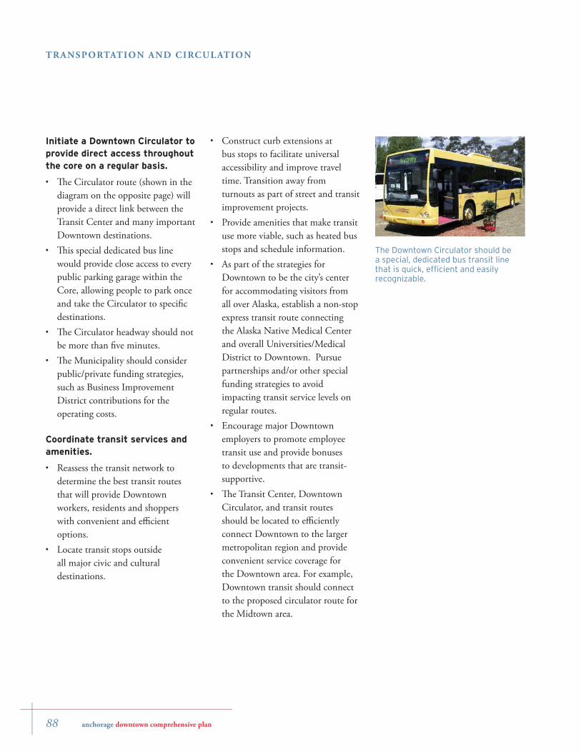
The Downtown Circulator should be a special, dedicated bus transit line that is quick, effi cient and easily recognizable.
Construct curb extensions at bus stops to facilitate universal accessibility and improve travel time. Transition away from turnouts as part of street and transit improvement projects.Provide amenities that make transit use more viable, such as heated bus stops and schedule information.As part of the strategies for Downtown to be the city’s center for accommodating visitors from all over Alaska, establish a non-stop express transit route connecting the Alaska Native Medical Center and overall Universities/Medical District to Downtown. Pursue partnerships and/or other special funding strategies to avoid impacting transit service levels on regular routes.Encourage major Downtown employers to promote employee transit use and provide bonuses to developments that are transit-supportive. Th e Transit Center, Downtown Circulator, and transit routes should be located to effi ciently connect Downtown to the larger metropolitan region and provide convenient service coverage for the Downtown area. For example, Downtown transit should connect to the proposed circulator route for the Midtown area.
•
•
•
•
•
Initiate a Downtown Circulator to provide direct access throughout the core on a regular basis.
Th e Circulator route (shown in the diagram on the opposite page) will provide a direct link between the Transit Center and many important Downtown destinations. Th is special dedicated bus line would provide close access to every public parking garage within the Core, allowing people to park once and take the Circulator to specifi c destinations.Th e Circulator headway should not be more than fi ve minutes.Th e Municipality should consider public/private funding strategies, such as Business Improvement District contributions for the operating costs.
Coordinate transit services and amenities.
Reassess the transit network to determine the best transit routes that will provide Downtown workers, residents and shoppers with convenient and effi cient options.Locate transit stops outside all major civic and cultural destinations.
•
•
•
•
•
•
anchorage downtown comprehensive plan 89
TRANSPORTATION AND CIRCUL ATION
P
P
P
P
P
P
P
I AL EK
9TH
G C
H
5TH
8TH
6TH
4TH
7TH
3RD
F
2ND
B
M
BARR
OW
CORD
OVA
EAG
LE
FAIR
BAN
KS
DEN
ALI
CHRISTENSEN
2ND
D
CORD
OVA
F
B
M
EAG
LE
DEN
ALI
1ST
10TH
GAM
BELL
HYD
ER
8TH
7TH
N
P
O
KnikArm
Delaney Park
Museum ofHistoryand Art
MemorialCemetery
5th Avenue Mall
CityHall
TownSquare
CaptainCook Hotel
MarriottHotel
ConocoPhillips
AtwoodBuilding
SOUTH ADDITION
FAIRVIEW
BOOTLEGGERS'COVE
FireStation
Sheraton
WeekendMarket
PerformingArts Center
QuyanaPark
Holy FamilyCathedral
StateCourthouse
4th AveTheater
Old FederalBuilding
Hilton Hotel
Kimballs
Federal Building
Nordstrom's
FederalBuilding
Egan Center
P
T
T
P(underway)
NewConvention
Center(underway)
LegendDowntown Study Area Park/Open Space
"Notable" Building Footprint Transit StationT
Parking StructurePPrimary Pedestrian Connection
Secondary Pedestrian ConnectionDowntown Core
Proposed DowntownCirculator Bus Route
Pa r k i n g a nd P ede s t r i a n Conne c t i o n s D i ag r am
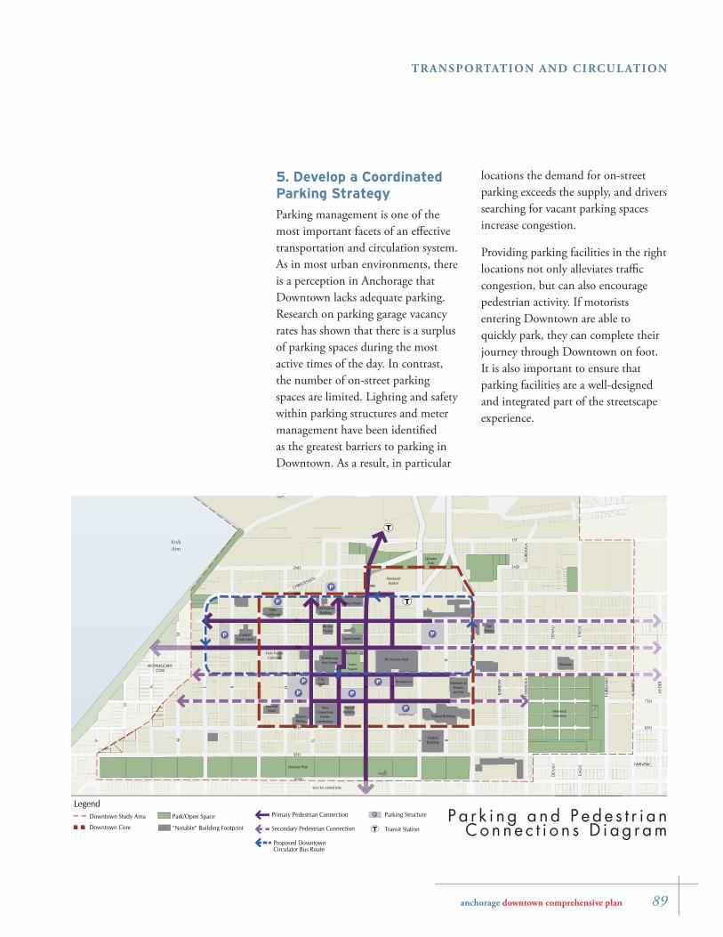
locations the demand for on-street parking exceeds the supply, and drivers searching for vacant parking spaces increase congestion.
Providing parking facilities in the right locations not only alleviates traffi c congestion, but can also encourage pedestrian activity. If motorists entering Downtown are able to quickly park, they can complete their journey through Downtown on foot. It is also important to ensure that parking facilities are a well-designed and integrated part of the streetscape experience.
5. Develop a Coordinated Parking Strategy
Parking management is one of the most important facets of an eff ective transportation and circulation system. As in most urban environments, there is a perception in Anchorage that Downtown lacks adequate parking. Research on parking garage vacancy rates has shown that there is a surplus of parking spaces during the most active times of the day. In contrast, the number of on-street parking spaces are limited. Lighting and safety within parking structures and meter management have been identifi ed as the greatest barriers to parking in Downtown. As a result, in particular
90 anchorage downtown comprehensive plan
TRANSPORTATION AND CIRCUL ATION
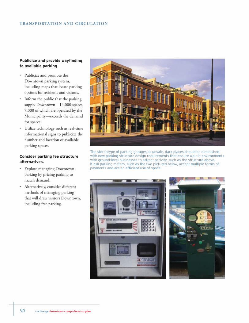
The stereotype of parking garages as unsafe, dark places should be diminished with new parking structure design requirements that ensure well-lit environments with ground-level businesses to attract activity, such as the structure above. Kiosk parking meters, such as the two pictured below, accept multiple forms of payments and are an effi cient use of space.
Publicize and provide wayfi nding to available parking
Publicize and promote the Downtown parking system, including maps that locate parking options for residents and visitors. Inform the public that the parking supply Downtown—14,000 spaces, 7,000 of which are operated by the Municipality—exceeds the demand for spaces.Utilize technology such as real-time informational signs to publicize the number and location of available parking spaces.
Consider parking fee structure alternatives.
Explore managing Downtown parking by pricing parking to match demand.Alternatively, consider diff erent methods of managing parking that will draw visitors Downtown, including free parking.
•
•
•
•
•
anchorage downtown comprehensive plan 91
TRANSPORTATION AND CIRCUL ATION
Provide on-street parking opportunities.
Maintain parking lanes wherever possible.Transition to the kiosk system of parking meters that accept multiple forms of payment and reduce sidewalk impediments.Implement and manage time limits and fees for on-street parking to help encourage parking turnover. On-street parking fee structure and time limits should favor shoppers, not employees. Greater on-street parking turnover Downtown leads to less congestion. It also benefi ts businesses by increasing the amount of parking for potential customers.
Strategically locate parking garages.
Locate public parking to capture motorists at the earliest and most convenient locations upon entering Downtown.Seamlessly connect parking garages to pedestrian-friendly streets and transit systems, including the Downtown Circulator.As Downtown builds out in the future, consider developing parking garages under Delaney Park.
•
•
•
•
•
•
Design pedestrian-friendly parking facilities.
Screen surface lots with landscaping, and put active uses on the ground fl oor of parking structures. For a more complete description of design guidelines regulating parking facilities, please refer to Chapter 6: Urban Design.Require parking structures to be well-lit, easy to navigate and well-marked.
Operate Commercial Surface Lots and Parking Facilities to Better Meet Customer Service Needs.
Require all owners of commercial surface parking lots and parking facilities, including out-of-state owners, to maintain a local offi ce for transactions of business and customer service.Require owners of commercial surface parking lots and parking facilities to improve sidewalk maintenance, especially winter snow removal on public areas.
•
•
•
•
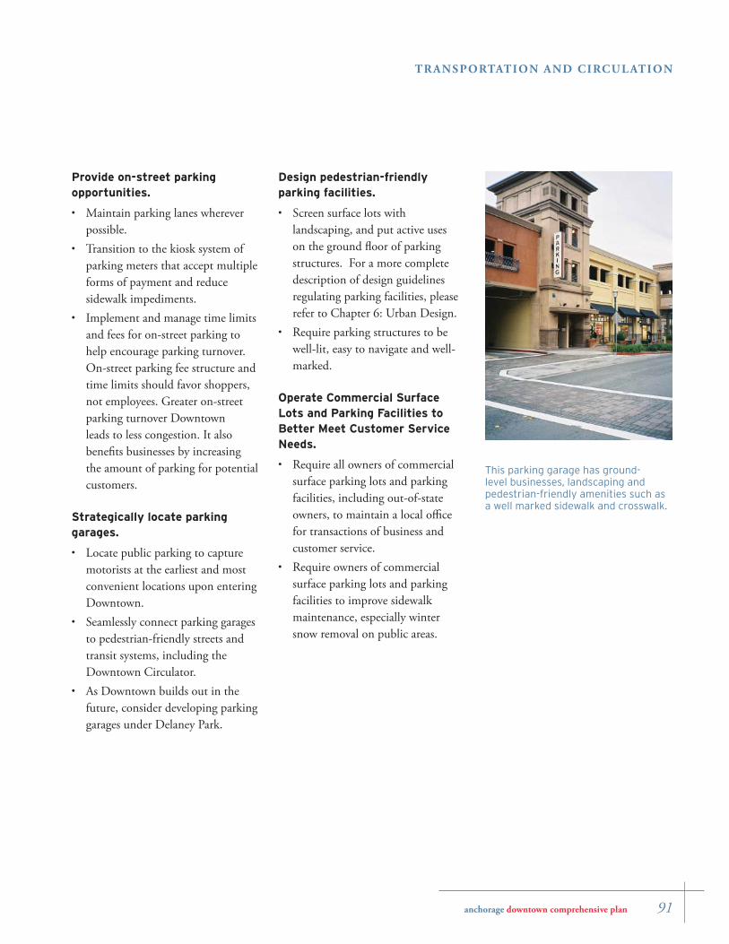
This parking garage has ground-level businesses, landscaping and pedestrian-friendly amenities such as a well marked sidewalk and crosswalk.
92 anchorage downtown comprehensive plan
TRANSPORTATION AND CIRCUL ATION
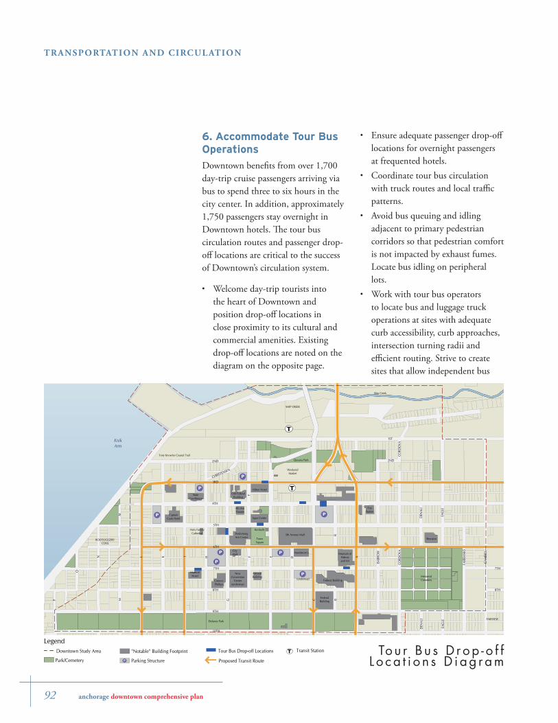
6. Accommodate Tour Bus Operations
Downtown benefi ts from over 1,700 day-trip cruise passengers arriving via bus to spend three to six hours in the city center. In addition, approximately 1,750 passengers stay overnight in Downtown hotels. Th e tour bus circulation routes and passenger drop-off locations are critical to the success of Downtown’s circulation system.
Welcome day-trip tourists into the heart of Downtown and position drop-off locations in close proximity to its cultural and commercial amenities. Existing drop-off locations are noted on the diagram on the opposite page.
•
P
P
P
P
P
P
P
T
T
I AL EK
9TH
G C
H
5TH
8TH
6TH
4TH
7TH
3RD
F
2ND
B
M
BARR
OW
CORD
OVA
EAG
LE
FAIR
BAN
KS
DEN
ALI
CHRISTENSEN
2ND
D
CORD
OVA
F
B
M
EAG
LE
DEN
ALI
1ST
10TH
GAM
BELL
8TH
7TH
N
P
O
KnikArm
Delaney Park
Museum ofHistoryand Art
MemorialCemetery
5th Avenue Mall
Quyana Park
CityHall
TownSquare
Tony Knowles Coastal Trail
Ship Creek
CaptainCook Hotel
MarriottHotel
ConocoPhillips
AtwoodBuilding
SHIP CREEK
FAIRVIEW
BOOTLEGGERS'COVE
FireStation
Sheraton
WeekendMarket
PerformingArts Center
Holy FamilyCathedral
StateCourthouse
4th AveTheater
Old FederalBuilding
Hilton Hotel
Kimballs
Federal Building
Nordstrom's
FederalBuilding
Egan Center
P(underway)
NewConvention
Center(underway)
Legend
Proposed Transit Route
Transit StationTDowntown Study Area
Park/Cemetery
"Notable" Building Footprint
Parking StructureP
Tour Bus Drop-off Locations Tou r B u s D r op - o f f L o ca t i o n s D i ag r am
Ensure adequate passenger drop-off locations for overnight passengers at frequented hotels.Coordinate tour bus circulation with truck routes and local traffi c patterns.Avoid bus queuing and idling adjacent to primary pedestrian corridors so that pedestrian comfort is not impacted by exhaust fumes. Locate bus idling on peripheral lots.Work with tour bus operators to locate bus and luggage truck operations at sites with adequate curb accessibility, curb approaches, intersection turning radii and effi cient routing. Strive to create sites that allow independent bus
•
•
•
•
anchorage downtown comprehensive plan 93
TRANSPORTATION AND CIRCUL ATION
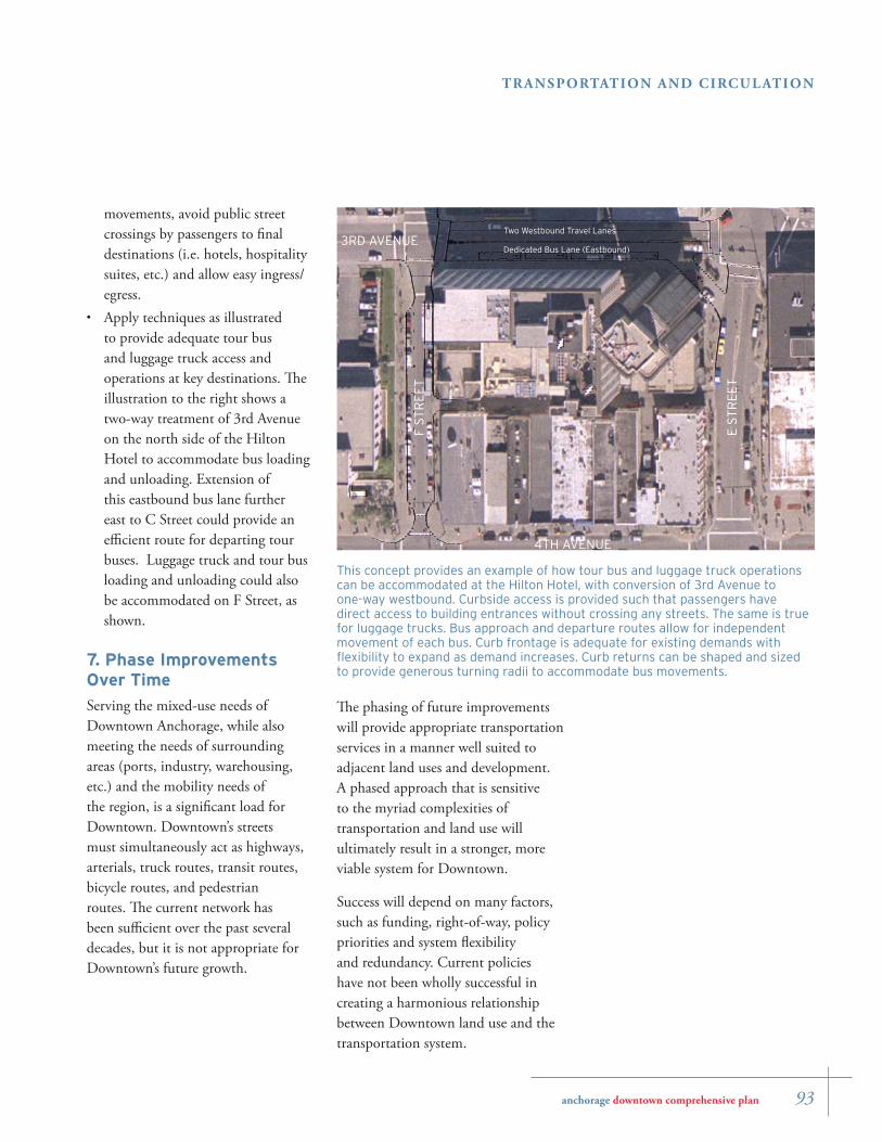
This concept provides an example of how tour bus and luggage truck operations can be accommodated at the Hilton Hotel, with conversion of 3rd Avenue to one-way westbound. Curbside access is provided such that passengers have direct access to building entrances without crossing any streets. The same is true for luggage trucks. Bus approach and departure routes allow for independent movement of each bus. Curb frontage is adequate for existing demands with fl exibility to expand as demand increases. Curb returns can be shaped and sized to provide generous turning radii to accommodate bus movements.
Dedicated Bus Lane (Eastbound)
Two Westbound Travel Lanes3RD AVENUE
4TH AVENUE
E S
TR
EE
T
F S
TR
EE
T
movements, avoid public street crossings by passengers to fi nal destinations (i.e. hotels, hospitality suites, etc.) and allow easy ingress/egress.Apply techniques as illustrated to provide adequate tour bus and luggage truck access and operations at key destinations. Th e illustration to the right shows a two-way treatment of 3rd Avenue on the north side of the Hilton Hotel to accommodate bus loading and unloading. Extension of this eastbound bus lane further east to C Street could provide an effi cient route for departing tour buses. Luggage truck and tour bus loading and unloading could also be accommodated on F Street, as shown.
7. Phase Improvements Over Time
Serving the mixed-use needs of Downtown Anchorage, while also meeting the needs of surrounding areas (ports, industry, warehousing, etc.) and the mobility needs of the region, is a signifi cant load for Downtown. Downtown’s streets must simultaneously act as highways, arterials, truck routes, transit routes, bicycle routes, and pedestrian routes. Th e current network has been suffi cient over the past several decades, but it is not appropriate for Downtown’s future growth.
•
Th e phasing of future improvements will provide appropriate transportation services in a manner well suited to adjacent land uses and development. A phased approach that is sensitive to the myriad complexities of transportation and land use will ultimately result in a stronger, more viable system for Downtown.
Success will depend on many factors, such as funding, right-of-way, policy priorities and system fl exibility and redundancy. Current policies have not been wholly successful in creating a harmonious relationship between Downtown land use and the transportation system.
94 anchorage downtown comprehensive plan
TRANSPORTATION AND CIRCUL ATION