Embed Size (px)
Citation preview
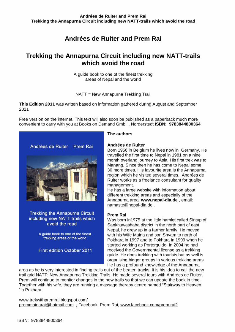
Andrées de Ruiter and Prem Rai Trekking the Annapurna Circuit including new NATT-trails which avoid the road
ISBN: 9783844800364
Andrées de Ruiter and Prem Rai
Trekking the Annapurna Circuit including new NATT-trails which avoid the road
A guide book to one of the finest trekking
areas of Nepal and the world
NATT = New Annapurna Trekking Trail This Edition 2011 was written based on information gathered during August and September 2011 Free version on the internet. This text will also soon be published as a paperback much more convenient to carry with you at Books on Demand GmbH, Norderstedt ISBN: 9783844800364
The authors Andrées de Ruiter Born 1956 in Belgium he lives now in Germany. He travelled the first time to Nepal in 1981 on a nine month overland journey to Asia. His first trek was to Manang. Since then he has come to Nepal some 30 more times. His favourite area is the Annapurna region which he visited several times. Andrées de Ruiter works as a freelance consultant for quality management. He has a large website with information about different trekking areas and especially of the Annapurna area: www.nepal-dia.de , email: [email protected] . Prem Rai Was born in1975 at the little hamlet called Sintup of Sankhuwashaba district in the north part of east Nepal, he grew up in a farmer family. He moved with his Wife Maina and son Shyam to north of Pokhara in 1997 and to Pokhara in 1999 when he started working as Porterguide. In 2004 he had received the Governmental license as a trekking guide. He does trekking with tourists but as well is organising bigger groups in various trekking areas. He has a profound knowledge of the Annapurna
area as he is very interested in finding trails out of the beaten tracks. It is his Idea to call the new trail grid NATT: New Annapurna Trekking Trails. He made several tours with Andrées de Ruiter. Prem will continue to monitor changes in the new trails so that we can update the book in time. Together with his wife, they are running a massage therapy centre named “Stairway to Heaven “in Pokhara www.trekwithpremrai.blogspot.com/ [email protected] , Facebook: Prem Rai, www.facebook.com/prem.rai2
Andrées de Ruiter and Prem Rai Trekking the Annapurna Circuit including new NATT-trails which avoid the road
ISBN: 9783844800364 2
First edition October 2011
The authors ............................................................1 Foreword: ...............................................................3 Painting the Himalayas...........................................4 The marks: .............................................................4 Status August 2011 ................................................4 General facts about trekking ...................................5 Cigarettes & Co ......................................................6 In Kathmandu: ........................................................7 Getting to the Annapurna area:...............................7 Trail description with NATT trails ............................8 Possible schedules.................................................8 The need for a good altitude acclimatization...........9 From Besisahar to Bhulbhule..................................9 Bhulbhule ...............................................................9 Bhulbhule- Bahundanda .......................................10 Ghermu ................................................................10 Syange-Jagat .......................................................10 Jagat – Chamje ....................................................11 Tal ........................................................................11 Tal to Dharapani ...................................................11 Bagarchhap - Danaque –Temang.........................12 Thanchouk – Koto – Chame .................................12 Chame - Bhratang ................................................12 Bhratang - Dhukur Pokhari ...................................13 Upper Pisang** 3400m .........................................13 Ghyaru **..............................................................14 Ngawal ** 3660m..................................................14 Braka *** (Braga) 3470 m .....................................15 Side trips from Braka ............................................16 Ice Lake ** ............................................................16 Milarepas’ Cave ** ................................................16 Manang * 3500 m .................................................16 Day hikes from Manang:.......................................17 Side Trek to Khangsar and Tilicho Lake ...............17 Manang to Khangsar 2 hours................................18 The “Grande Barriere” *** .....................................18 Going to Tilicho Lake ***.......................................18 Crossing Tilicho Lake to Jomsom .........................19 Manang to Yak Kharka or Churi Ledar..................19 Crossing Thorong La and the dangers of High Altitude Sickness 20 Churi Ledar to Thorong Phedi...............................21 Climbing up to High Camp....................................22 From high camp to Thorong la 3-4 hours..............22 Thorong La to Muktinath 4-5hours........................22 Muktinath ***.........................................................23 Ranipauwa ~3770 m.............................................24 Jharkot **..............................................................25 Lubra ** (also Lupra).............................................26 Lubra to Jomsom 2 hours .....................................26
Andrées de Ruiter and Prem Rai Trekking the Annapurna Circuit including new NATT-trails which avoid the road
ISBN: 9783844800364 3
Muktinath -Ranipauwa to Kagbeni *** ...................26 Chongur **............................................................27 Jhong ** (also Dzong)...........................................27 Jhong ** to Putak* ................................................27 My love Kagbeni 2800m .......................................28 Tiri 2800 m ...........................................................29 Kagbeni - Jomsom standard route 2, 5 hrs ...........30 High route from Kagbeni to Jomsom **.................30 Jomsom 2720 m...................................................30 Jomsom to Marpha by road 1-1, 5 hrs ..................31 Jomsom to Marpha by the new NATT- trail...........31 Marpha *** ............................................................32 Marpha - (Tukuche) - Kokhethanti ........................32 Tukuche................................................................33 Chokhopani to Sauru (2-2,5 hrs)...........................33 Sauru to Sirkung and Kokhethanti ........................33 Kokhethanti - Titi Lake, Taglung - Kalopani ..........33 Kalopani ...............................................................34 The forest trail from Lete to Ghasa **....................35 Ghasa 2010m.......................................................35 Dana.....................................................................36 Tatopani – Pokhara by Bus or Jeep......................36 From Tatopani to Ghorepani and Poon hill *** ......37 Ghorepani 2860 m................................................37 Poon hill *** ..........................................................37 Tadapani – Gandrung – Birethanti - Nayapul........37 Pokhara *** 800 m................................................38 What to do in Pokhara? ........................................38 Continuing from Pokhara: .....................................39 Foreword: Once upon a time the Annapurna Circuit was one of the most beautiful trekking areas of Nepal. Then in a general national plan for developing Nepal a large programme of road building was started with the goal that every district head quarter was connected by road. The department of road started to plan roads to Manang and Jomsom. As Nepali people use to walk in the mountains only for visiting relatives or make some business they don’t mind at all to walk along streets as it is faster and easier. Therefore no one of the responsible realy realised that trekkers have a completely different view how a trekking trail should be and that no trekking tourist would like to walk on a dusty road chased by horning trucks and motorcycles. Quite a few lodge owners foresaw the problems, but there was a strong lobby of villagers who saw many advantages. In fact a road means a better possibility to sell theirs own farm products like apples, thus earning more, and in the same time other goods brought by the road are much cheaper than carried by mule or porter. This results in a higher life standard. Also travelling is much easier And so the road construction started but no one cared to plan already alternative trekking trails. It was only when the road between Beni and Muktinath was finished that the highly negative impact on trekking tourism was understood. In 2010 many tour operators in Europe had stopped treks in the Jomsom area and in the Internet many individual trekkers said that it is no more fun to trek down the road and suggested just to take the bus after Jomsom or even directly jump into a jeep in Muktinath/Ranipauwa In 2006 ACAP started planning a full alternative trekking trail avoiding the road and they are busy making new trails. We call them New Annapurna Trekking Trails = NATT. There is more and more a complete grid so that one can not only make the classical Annapurna circuit but also enjoy
Andrées de Ruiter and Prem Rai Trekking the Annapurna Circuit including new NATT-trails which avoid the road
ISBN: 9783844800364 4
many side trips. Both the Manang and the Jomsom side can be visited in a marvellous trekking experience just on there own without crossing Thorong La. Why this book is published in book on demands When I looked to the books on Annapurna area it appeared that they were all absolutely outdated, most being printed in 2009. A printed book will always take more than half a year only for printing preparation and then the publishers want to sell first the remaining stock before making a new edition. When in August 2011 I explored the new trails in the Annapurna region I realised that it is very important that this information will be available very soon to the trekkers (if possible in October 2011). This is only possible with the system of books on demand, where only a file is stored and then the books are printed one by one only if someone orders one. The main advantage is that there is absolutely no stock and that one can change easily the file. If there is enough demand this book will be probably updated at least twice a year based on the information Prem Rai is collecting from the field. So see this edition as a first quick and roughly start just giving you the information to explore all these new and beautiful NATT treks. So please excuse the many tipping and language errors. I hope that even with them this little book will help you to experience beautiful new trails you would have missed without it.
Painting the Himalayas With my Nepali Partner Prem Rai I visited the Jomsom trek in December 2010 and we could walk nearly all the way to Tatopani along the separate pure trekking trail. I was very pleased but we had quite often problems finding the right trail at various junctions. Therefore we approached ACAP in Pokhara and I explained the system of marking trekking trails in the European Alps by painting rocks or trees on the way. This is a much easier, much more economical and efficient way than only putting signposts. We proposed to use red/white marks for the main AC trail and blue/white marks for side trails. ACAP liked this suggestion and so Prem Rai and I started in August 2011 with 5 litres of enamel in Besisahar. In the Kali Gandaki valley we were joined by the Jomsom ACAP staff members Mr. Rishi Ram Dhakal and after two day by Mr. Bel Bahadur Pun and the Guide Mr. Hari Nepali.
The marks: In addition to the signposts we marked the trail by painting marks on rocks, electric poles houses and sometime trees. As long as the trail is obvious we did not mark when the trail is following the road. Some times we had to add some arrows to explain the route, but often you just have to look a little bit around on a junction and you will see the next sign. We all from the Himalaya Painting Team hope that, it will make easier for trekkers to follow these sometime little trails.
Status August 2011 Manang side: Actually just a part of the road on the Marsyangdi side (Manang trek) is in use, the buses from Kathmandu and Dumre ride till Bhulbhule, in the dry season Jeeps continue to Syange or sometimes up to Jagat. There is heavy blasting works on the cliffs opposite Tal and it will take several months before a vehicle can pass this difficult stretch. After the cliffs the road is ready till Danaqiu. There the road is still under construction with heavy blasting and road works high above the river going to Temang. Because of the blasting and rocks falling down from the road all the area below is still closed and the people of Latamarang have been evacuated. The road is finished till Chame and then partially till Manang. As there is no get through before Tal there is no traffic above Jagat except road constructing machines and tractors. Jomsom side: There is a gravel road which connects Beni to Muktinath and upper Mustang.
Andrées de Ruiter and Prem Rai Trekking the Annapurna Circuit including new NATT-trails which avoid the road
ISBN: 9783844800364 5
In the winter season several buses a day ride up to Jomsom. From there Jeeps make the connection up to Muktinath Ranipauwa, carrying hundreds of Indian pilgrims to the temple area. As most of them just arrived in the morning, the high altitude is hard and many of the elder pilgrims will gladly ride back to the jeep parking place on a motorcycle. Fortunately there is now the possibility to trek all the way down to Tatopani avoiding nearly completely the road. So please forget everything like it is not worth anymore to trek down to Tatopani. The Jomsom trek is again one of the best trekking areas of the World
General facts about trekking Trekking Seasons: Fall: this is the most popular trekking season starting from October to the mid of December. The monsoon stops around Begin to Mid of October. But be careful, often there is still many das of rain in the first half of October so I would suggest not to start before the 15th of October. Most of the times the sky will be very clear with good mountain views. In October the fields and pastures are still green. October is still warm and sometimes people cross Thorong la in shorts. But be prepared that in the mountains it can always be suddenly very cold. I once had even snow just above Manang in October! In November the weather is getting much colder but the mountains views are crystal clear. Mid. November to mid. December is usually a very dry season. In the second half of December winter storms coming from the north can bring snow and rain. In November I always have a very warm sleeping bag and a cosy down jacket with me. Winter: Mid December to end of February. This is the very cold season with temperatures going down sometimes below -20° C on Thorong la and sometimes freezing temperatures in the sleeping rooms of the lodges. Definitively a down jacket will make you trek much nicer, as most of the lodges will not be realy heated. Even in winter, most of the time a small foot spoor will be made by trekkers so that one can cross Thorong la. But it may be not possible for several days after a snow period. Spring: March to June. This is a very nice season, with rhododendrons trees flourishing around Ghorepani. You will see many flowers. The weather is mostly clear in the morning but soon getting dizzy. The later you are in spring the sooner clouds will mask the mountains. Expect to have regularly some rain showers during the day. An umbrella is a must during this season. Monsoon: July to begin of October. I have trekked twice in monsoon season and it was both times very nice. In August 2011 I used during 23 trekking days my umbrella only for 10 hours! You will rarely see any mountain, just sometimes for a few minutes as the summits are nearly always in the clouds. But there will be enough sun to get bad sunburn! You will see many beautiful flowers and colourful butterflies for people who have visited the area before so that they know the Mountain View, Monsoon is a very interesting and rewarding trekking season. An umbrella is a must as you would be boiled wearing a closed rain coat. Lodges There is a long tradition of Nepali people trekking in the Himalaya as it is very common that people visit their parents or relatives on various festivities. AS the first roads were built in the 70ties it was and is just normal that people will walk for days. To give them food and shelter many families opened a little tea shop along the trails. There one could get tea, dal bhat and in the night one could sleep on the floor or sometime some beds where available. When I first went to Manang in 1981. In Manang these Teahouses were the standard and in remote trekking areas you will still find and use them. The tradition of the teahouse was that you only had to pay for the food. For this reason the price for an accommodation is still very low. But lodges will ask you not to eat in another place or to pay a much higher accommodation price. Soon the standard started much to improve and on the
Andrées de Ruiter and Prem Rai Trekking the Annapurna Circuit including new NATT-trails which avoid the road
ISBN: 9783844800364 6
Annapurna circuit the lodges an excellent. Normally you will have a small room with two beds and just a small place to put your bag pack. Often the walls between the rooms are just made of wooden planks. You will get a padlock from the lodge if you don’t have your own one. You should bring your own sleeping bag with you, even when most lodges will provide some extra blankets. But it is much more hygienic to have just your own bag to avoid getting free bed bugs ;-). On the AC there is normally never a problem to find a lodge to sleep sometimes you will not get the one you where looking at but you will get always sleeping place. As the general standard is rather similar, I don’t recommend in general any lodges like Lonely planet does. First I could not check them all and my experience is that rarely the recommended are really better than other ones but much more crowded. And it is not just for the other lodges which should have an equal chance. For me the most important criterion to choose a lodge is the smile of the didi. If I like it I will be probably happy for the rest of the evening. Food and drinks There is a reason that parts of the Annapurna circuit are called apple pie trek. And fact the food is generally excellent. You will find a menu card with classical food like dal bhat (rice with lentil soup and curry vegetables) and many other items like pasta. More and more you will find also meat on the menu card. The choice for breakfast is also copious from muesli or porridge to chapati and eggs any style. Tibetan bread is fried and delicious. If you are travelling with porters or Nepali guides, they will want to have a dal bhat around 11-12 AM. Be aware that it may take 1, 5 hours to prepare it. Better have a noodle soup or fried noodles for lunch as it will be ready much faster. There is a large choice of drinks: various teas, coffee and cold drinks. On the upper part of the AC in the Buddhist areas ask for “suchia”, the Tibetan style salted butter tea. Don’t expect a tea but rather a sort of soup or bouillon. It definitively worth the try! An other speciality of this area is the sea buckthorn juice. You will pass many of the little bushes. The berries are collected and syrup made of them. Surprisingly the prices are lower on the Jomsom side, even when the syrup is carried over Thorong la. You might just buy a bottle of syrup and mix your own juice. On many places of the Annapurna circuit you will find safe water drinking station. This water is purified and disinfected and much cheaper than the bottled one. This water is safe. Bring you own bottle to be filled.
Cigarettes & Co You can buy cigarettes, toilet paper or chocolate bars in every lodge, so there is no need to bring it all along the way. Money: You will need Nepali Rupees on the trek. Even when sometimes it was possible to get money with a credit card in Jomsom or Marpha I would never relay on this possibility as it is often not possible. So this means have cash with you. You can change traveller cheques or foreign currency at various places on the AC. But in the lodges they will ask you NPR. The best place for change is Kathmandu where you can either change in a bank or with private money changers. In Thamel the bank near fire and Ice offers sometime better rates then the private money changers. Also the money changer in Freakstreet has better rate then Thamel money changers. There are also many ATM in Kathmandu and Pokhara giving Cash on credit cards. In 2011 no ATM in Pokhara was giving me Cash on my EC Card with Maestro system. I’m carrying all my money in a money belt. Life is getting more and more expensive in Nepal. Count at least 20 Euro/30 USD per day. If you don’t spent all the money during the trek you will need it anyway afterwards easily in Pokhara and Kathmandu. But it is realy bad running out of money during the trek. If you like to drink some beer be aware that a bottle will be around 300-350 NPR which could increase much your expenses. Arriving in Nepal Visa: Your passport must be valid up to 6 months after you planned departure from Nepal. You can get a 30 or 100 Day visa directly at the airport. If you want to extent it, you have to go to immigration office in Kathmandu or Pokhara. There is no possibility to extent a visa in a trekking area.
Andrées de Ruiter and Prem Rai Trekking the Annapurna Circuit including new NATT-trails which avoid the road
ISBN: 9783844800364 7
In Kathmandu: Medicine: Crossing Thorong la bears a high risk of getting altitude sickness. As long that you are in Kathmandu take the opportunity to buy, by the way of precaution the emergency drugs Dexamethasone (4 x 4 mg) and Nifedifine (also 4 tablets). They are the only drugs helping when you have severe high altitude sickness. The price is less than a cup of tea but it could help you to go safely down or even save your life. You can just buy them at every pharmacy without prescription. Many people only know Diamox. This drug can help you to feel better but when you are realy in trouble (HACE or HAPE) it is not efficient. Getting the Permits: You need one Permit for the Annapurna Conservation Area Project ACAP, which costs 2000 NPR. In August 2011 you still need to register for a TIMS permit. This permit was designed and lobbied by the Trekking Agencies Association of Nepal TAAN. It is supposed to help to find lost trekkers and speed help but in my view it is not working at all and is mainly aimed to constrain individual trekkers. The Permits are checked on various Checkposts around the Annapurna circuit. You can get both permits either trough any TAAN affiliated Trekking agency which will charge you a little fee or get them yourself, which will take not more than an hour. Getting the Permits in Kathmandu: Go to the Nepal Tourism Board (NTB) Tourist Information Centre which is east of Ratna Park about 15-20 min from Thamel. You can get there both Permits Getting the permits in Pokhara: When you arrive by bus, just a walk about 100m from the Tourist Bus Park in direction of lakeside (west) to the next crossing. Turn left and go down in direction of the damside. There you will find the tourist centre on the right hand. It is less than 10 min walk. To walk from there till Lakeside will take you another 25 min.
Getting to the Annapurna area: Going directly from Kathmandu to Besisahar/Bhulbhule
The direct buses start from the new Kathmandu Bus Station called Gongabu Station in the north of Thamel on the ring road. It’s a little bit hidden and you have first to pass a along a shopping mall before you enter the bus park area. You will need a taxi drive to go there which will cost you nearly the same price than the bus ride to Bhulbhule! (Thamel - Gongabu 200-250 NPR in Aug. 2011). The station is rather confusing but the tickets counters are all in a hall on the left corner at the end of the station. You should buy the tickets a day in advance. Travel agents can organise a ticket charging a fee.
Going first to Dumre then to Besisahar You can take a normal tourist bus in direction of Pokhara and jump out in Dumre. There you take one of the many busses or mini busses going up to Besisahar or Bhulbhule. The Tourist buses start every morning on Kantipath just 15 min walking distance from Thamel at 7:00. Every hotel will organise for you the ticket even in the evening. This is the main advantage if you have little time. The bus ride is more expensive, but you save the taxi drives. And it will take longer than the direct bus. Starting from Pokhara The bus from Pokhara to Besisahar starts at 7:00 from the Pokhara Bus Park
Andrées de Ruiter and Prem Rai Trekking the Annapurna Circuit including new NATT-trails which avoid the road
ISBN: 9783844800364 8
Trail description with NATT trails Riversides: The riversides are always defined looking from the source down the river. Lodges: The classical lodge is rather basic but the standard in the Annapurna area is rather high. Normally you will get a small room, just enough to put two little beds and space for your bag packs. Often the rooms are on the first floor and the wall is just made of wooden planks. The rent is still very cheap but you are expected to eat at the lodge, in the past there was along tradition of Teahouses offering food for travellers. In the night people could sleep on the floor for free. If you decide to eat in an other lodge your lodge might ask you to pay a much higher rent.
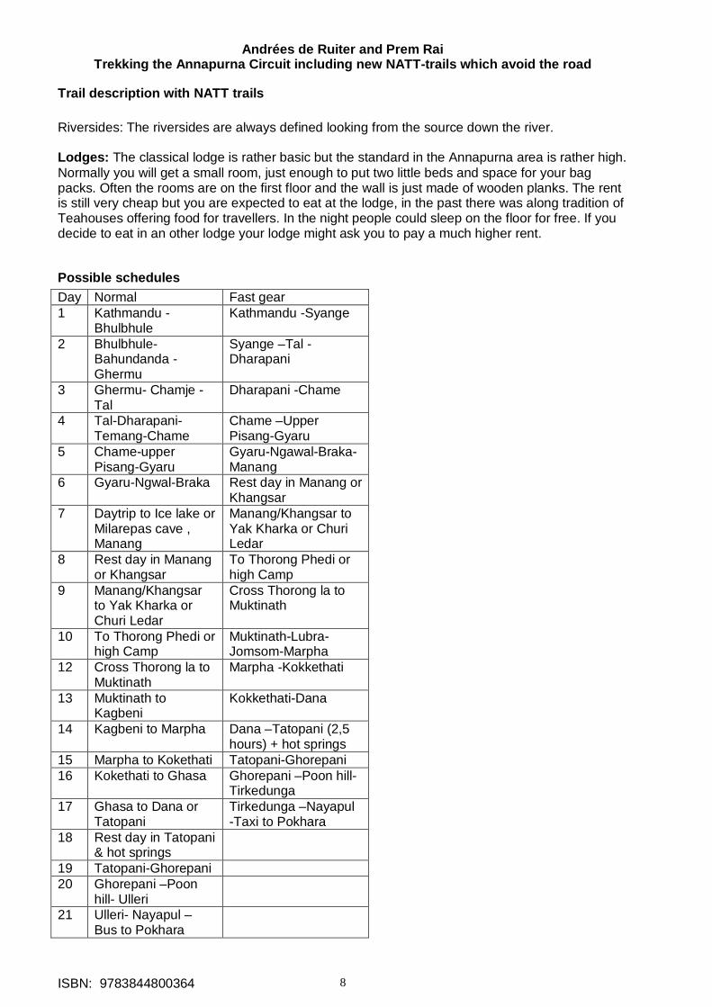
Possible schedules Day Normal Fast gear 1 Kathmandu -
Bhulbhule Kathmandu -Syange
2 Bhulbhule-Bahundanda - Ghermu
Syange –Tal - Dharapani
3 Ghermu- Chamje -Tal
Dharapani -Chame
4 Tal-Dharapani-Temang-Chame
Chame –Upper Pisang-Gyaru
5 Chame-upper Pisang-Gyaru
Gyaru-Ngawal-Braka-Manang
6 Gyaru-Ngwal-Braka Rest day in Manang or Khangsar
7 Daytrip to Ice lake or Milarepas cave , Manang
Manang/Khangsar to Yak Kharka or Churi Ledar
8 Rest day in Manang or Khangsar
To Thorong Phedi or high Camp
9 Manang/Khangsar to Yak Kharka or Churi Ledar
Cross Thorong la to Muktinath
10 To Thorong Phedi or high Camp
Muktinath-Lubra-Jomsom-Marpha
12 Cross Thorong la to Muktinath
Marpha -Kokkethati
13 Muktinath to Kagbeni
Kokkethati-Dana
14 Kagbeni to Marpha Dana –Tatopani (2,5 hours) + hot springs
15 Marpha to Kokethati Tatopani-Ghorepani 16 Kokethati to Ghasa Ghorepani –Poon hill-
Tirkedunga 17 Ghasa to Dana or
Tatopani Tirkedunga –Nayapul -Taxi to Pokhara
18 Rest day in Tatopani & hot springs
19 Tatopani-Ghorepani 20 Ghorepani –Poon
hill- Ulleri
21 Ulleri- Nayapul – Bus to Pokhara
Andrées de Ruiter and Prem Rai Trekking the Annapurna Circuit including new NATT-trails which avoid the road
ISBN: 9783844800364 9
The need for a good altitude acclimatization It is absolutely necessary that you stay at least two or better three night in the upper Manang valley before you continue to go further up to yak Kharka or Churi Ledar. Possible places are Gyaru, Ngawal, Braka, Manang and Khangsar Trekking from Begnas Tal This is a beautiful Trek which is taking by very few tourists. Therefore the lodges are very simple. But I liked it so much that I have taken it already three times. Take an early minibus from opposite the old bus park in Pokhara to Begnas Tal. In Begnas Tal take either the trail up to the ridge which offers beautiful views on the Annapurna range above the lake. Most people will take the bus to Karputar. From Karputar go to Syauli Bazar. There is one lodge in Bavarian style! Continue to the east cross the river and climb up a very steep hill to finally come to the beautiful village of Nalma. Continue along the ridge to reach the village of Baglungpani with on very basic lodge but a fantastic Dal Bhat. You will come once to a branch –off the trail, keep on the left side. Don’t miss in Baglungpani the sunset with a great panorama of Annapurna and Manaslu range from the ridge above the village. Continue from Baglungpani to the west and descent to the Marsyangdi valley and you will reach Khudi, which is not far away from Bhulbhule.
From Besisahar to Bhulbhule There is still a check post in Besisahar but most busses just drive without stopping there Besisahar-Bhulbhule by side trek 4 hours, 200 m climbing, 165m going down There is a very rewarding side trek through beautiful rice paddy fields from Besisahar to Bhulbhule bypassing most of the road. It is definitively a very nice alternative to a bumpy bus ride and many people who did it enjoyed it much. For me Nepal is not only the high mountain areas but as much I love the lower regions which I never would like to miss! When you are at the end of Besisahar where the road plunges down to the river you can take on the right hand a little shortcut trail leading directly to the river which you can cross on a little wooden bridge. After reaching the road you follow it for approximately for 30 min. On the way, you can already see the suspension bridge going over the Marsyangdi River. Between a few road shops the trail starts to the right, watch for the red white signs. Soon you will reach the bridge and cross the river. On the left the trail is going up through the villages of Lete, Mulbazar and Simalchaur. Simalchaur named from the Simal tree, which flowers in spring with big red flowers. From there you still have to climb a lot to reach the highest point at 1030 m (200m above Besisahar) On the way down you pass some houses and have a beautiful view on the Marsyangdi valley and the Manaslu range and you reach Bhulbhule passing a nice little Buddhist Stupa. You reach Bhulbhule, where people coming by bus will join you crossing the Marsyangdi on a long suspension bridge.
Bhulbhule This is actually the last bus. There are now lodges on the right (road) riverside and also the ACAP check post. You can continue with a jeep till Syange or even maybe to Jagat. The traditional trekking trail is on the left riverside and you cross the Marsyangdi River on a long suspension bridge. On my first treks I was very afraid crossing suspension bridges. On the way to Jomsom I nearly could not pass the bridge near Lete. Later I met two Australian girls and we came back together. Already two days before Lete I started to be nervous. And then I was puzzled as the girls were looking forward to pass this awful bridge, saying it is great fun! Ok. So I had to try to have a different psychological approach and crossed it first without my backpack and whistling a little tune. And it worked!!!! Since then I like crossing suspension bridges. Don’t be to
Andrées de Ruiter and Prem Rai Trekking the Annapurna Circuit including new NATT-trails which avoid the road
ISBN: 9783844800364 10
stiff when crossing, it is like dancing with a partner you have to follow the movements to enjoy it. Feel the swing of the bridge when you make it actively moving and you will love it! On the left river side there are several lodges, most of them in the classic basic but perfect style. It’s a wonderful place to pass the first evening listening to the sound of the river. Bhulbhule- Bahundanda 4 h Start from Bhulbhule on the main trail which is easy to follow. It’s not such a bad idea to continue from Bhulbhule the same afternoon if you have some hours left as you will be earlier climbing up the step hill of Bahundanda the next morning. Surrounded by green paddy fields you will pass along many nice garden lodges. First you will reach the little villages of Ngadi bazaar and then of Ngadi, where you cross on a huge suspension bride over the Ngadi Khola a side river of the Marsyangdi Khola. Continuing on the trail you will join again the road. When the road dips to the river and you can already see the bridge, on which the road crosses again the Marsyangdi to reach Syange, you turn sharply to the right and take the road going up. This road is constructed for a hydropower project further up. Instead of taking the side road to the right you just continue straight seeing already the houses of Bahundanda which are above a high ridge. You will have to climb this ridge, and in whatever month you will do it you will sweat a lot! So try to be there early in the morning, before the sun is heating up the south slopes like an oven. And you probably will get hallucinations of cold coke while climbing ;-). But once you are on the top you will be in a nice village with rewarding views. It is on 1310m and has 5 old style basic lodges and 2 newer which are a little bit above the village. Most people like very much Bahundanda and it is a perfect place for lunch. Bahundanda to Germu /Synge 2-2.5 hours After Bahundanda you will descent on a very steep trail with some stairs, which can be very slippery when it is raining. You reach again flat paddy fields and then the trail is going more or less on the same level through fields and forests and often high above the river. Finally you will reach Ghermu phant (plain land) with lodges stretched over more than 2 km. It is a pleasant place to relax in the afternoon as Ghermu is rather sunny.
Ghermu You can ask in the last lodge in Ghermu, the rainbow lodge, if there is already a trail to the second bridge on the way to Jagat. The landlord was thinking to improve and connect some little paths to a trail which would avoid another half hour walking on the road. Alternative High route from Ghermu: There is a possibility to avoid the road till Jagat by climbing up around 150 m to the villages Tallo Chipla and Mathilo Chipla. Then the trail will descend to the river which you can cross directly below Jagat, This route will take around 3-4 hours. I haven’t tried it yet but it looks very promising and would be also a very good exercise for your legs. At the end of Ghermu descent to the river and cross on a long suspension bridge to Syange. There are 5 lodges in Syange. One newer is a little further on the left near a huge waterfall but on the road. The road fortunately bypasses Syange from above but still one will hear every jeep. If you came by jeep and want to stay I suggest that you cross to Ghermu. It is just 15 – 20 min. away and much quieter and sunnier. There might be Jeeps riding from Syange further up to Jagat. Syange-Jagat 2, 5 hrs follow the new road to reach in 25 min the settlement of Chirchaur with to new lodges, both directly on the road. They advertise hot springs in 5 min, but one has to walk about 10 min, cross the river and it is just hot water coming from a tube without a pool. There are plans to build a proper pool on this side of the river bringing in the water by piping. The road later climbs in serpentines to Jagat. You may try short cuts but beware of falling rocks. You will pass a little house perched right on the side the trail like an eagle nest. During the civil war it was occupied by maobadis who had from here a perfect control of all the people coming up. From here you can already see the village of Jagat.
Andrées de Ruiter and Prem Rai Trekking the Annapurna Circuit including new NATT-trails which avoid the road
ISBN: 9783844800364 11
Jagat (1300m) has a community mainly of Tamang and Gurung. There are many lodges and restaurants. Actually the roads end up here. It is not clear if the road will later bypass Jagat or just go right through it. This would make it a very unpleasant place to stay. Jagat – Chamje 2 - 2, 5 hours: After Jagat the road begins again going to Chamje. Follow it till you reach the two teahouses of Ghatte Khola. When you passed the last one climb up the hill to the left on a NATT-trail marked with red/white signs. This is the old scenic trekking trail leading through a beautiful and romantic forest. You first have to climb some 130 m till the trail is getting nearly flat and you reach the Rainbow Waterfall Hotel, which got his name from the big waterfall just opposite on the other riverside. One other reason to take this trail is that by being higher above the river it is much quieter so that you can understand you companions without shouting all the time The Rainbow Waterfall Hotel is already on the same height than Chamje so finally the real difference in climbing for the two ways is less than 30 m. Entering upper Chamje after few minutes you will find 3 lodges which are much quieter than the ones right inside the village. If you want to stay in Chamje the upper part it is definitively the better choice From Upper Chamje you have to step down a small path to the road and you are at the entrance of main Chamje. Here you will find some more lodges. Probably the road will soon pass straight through the lower part of Chamje, Going AC clockwise: Chamje to Jagat just after the end of Chamje watch out for a little path on the right side going up and marked with the NATT red/white signs. It is the scenic old trail leading to Jagat. Chamje to Tal: 3 - 4 hours Just after Chamje, the construction of the road continues, going to the left hill. Turn right and descend a very step path, marked with red/white NATT signs going down to the river and cross it on a suspension bridge. After the bridge follow the trail passing a great waterfall. After 1:30 hour you will reach the two teashops and the houses of Sattale (1525) The Thorong Peak Hotel offers 6 double basic rooms. It might be a good choice to go there, if you have enough time left in Chamje, as you can start the climb to Tal early in the cooler morning. After some going up a down you reach the step climb to Tal, which has been formed by an enormous landslide blocking the whole valley like a dam. On the top you look down to the village of Tal with the waters of the normally very wild Marsyangdi being pond so that they flow just slow and gently. Most of the time, you can descent straight down to the river on the normal trail. Sometimes this way is over flooded and you must take the high route, which was build when a big rock fall destroyed the old path along the river some years ago, the water coming till the cliffs.
Tal Tal is a beautiful village, mainly lodges, but also some old houses. Here the valley widens and it is a very pleasant spot ideal for lunch or overnight stay. Behind the village is a huge waterfall which makes nice photos together with the horses, Tal is famous for. Fortunately the road will stay on the opposite riverside and not go through Tal, as some Nepali maps show. Tal to Dharapani Continue the trail along the river, after 25 min you reach 3 little garden lodges in Sirantal. All along on the other riverside one can see workers digging and blasting the new road out of the rock cliffs. Be careful, when they blast, small rocks hit your trail! But it is very interesting to watch all the people. At the end of the narrow gorge you climb up a little bit to go down again to a bridge and cross to the other riverside where you can walk on another stretch of the road. The plan is, that in December 2011/January 2012 a new trail will be completed going all the way from Tal to Dharapani on the eastern side, completely avoiding the road. This seems to be possible as there are the remains of an old trail existing. In this case you could continue instead of crossing the river.
Andrées de Ruiter and Prem Rai Trekking the Annapurna Circuit including new NATT-trails which avoid the road
ISBN: 9783844800364 12
One crosses again the river in at the village of Kabre with 3 lodges. Follow the river on a sometimes very small trail above the cliffs to reach again a bridge just before Dharapani. Dharapani stretches itself over at least 1,5 km with empty fields between the three village centres. First police want to check your TIMS and ACAP Permit in Dharapani Bazar, the ACAP wants to check your ACAP Permit in the last village part which I call Dharapani Bridge. There is a long suspension bridge leads into the valley going to Bimtang, which is part of the Manaslu round trek. There are several lodges in Dharapani in all of the village parts. Dharapani – Bagarchhap 45 min to 1:15 hours You can either follow the road trail which will lead you in about 45 min to Bagarchhap. In the guide books it is often said that it is just 30 min but normally it will take you around 45 min. There is a beautiful NATT alternative route. Cross the suspension bridge in Dharapani bridge leading to Manaslu area, but directly after the bridge turn left and enter the beautiful village of Thoche (one lodge). On the right side of the trail you will see a 100 year old little Nyngma- Gompa** which is absolutely worth visiting. Ask the old nun to open it. It has a very special atmosphere. From there just continue on a natural trail leading through fields and pastures and bushes till you reach an other suspension bridge. Cross it and climb to the road to be soon in Bagarchhap entering by an entrance chorten. Bagarchhap 2160 has a few lodges and some nice old houses near the stupa in the centre. The Gompa is rather new. Bagarchhap was devastated twice in the last 25 years by big landslides after heavy rain and some trekkers died there. Therefore I would never stay there, if it’s raining a lot. Bagarchhap - Danaque –Temang 2 - 2, 5 hours From Bagarchhap it is just a short way to the first houses of Danaque, a long village stretched over more than 1 km with several lodges. Be aware that the next lodges after Danaque are in Temang 1:45 hours further and a steep climb for more than 350 m. Follow the trail till the river and cross it over a little wooden bridge. the former trail going by Latamarang is actually closed, as the construction of the road with blasts and falling big rocks makes it an absolutely a no go area and all the people living there had to leave the area.After the bridge don’t take the road to the right but instead climb steeply up the hill. When you reach two small teashops it is not so long till you will be in Temang, where they are building like frenzy new big lodges. Obviously the think that with the new road hundreds of guest will jump out of the buses to stay there, I rather think they just pass by and trekkers will not want to stay directly near the road. My guess is that in a few years the trekking trail will pass again along the river by Latamarang. Temang -Thanchouk 1, 5 hours as you have reached the height of Temang the trail goes with little ups and down to the first village of upper Thanchouk (1hr) which consist mainly of lodges, from there it is another 20 min to the main village of Thanchouk. Thanchouk is a beautiful old village built on a ridge worth seeing. So turn to the right and make a little sightseeing village tour. There is one lodge in the village along the trail and two other lodges 10 minutes after the village. Thanchouk – Koto – Chame 1, 5-2 hours Follow the road trail for about 1hr to reach the old village of Koto with some nice old wooden houses. Just before the police check post at the end of the village the trail going for Nar and Phu turns to the right, but for this trek you still need a special trekking permit. After 20 min you will already reach the first lodges of Chame-Trichyunggaltha. But it is another 10 min walking till the main village of Chame begins, which is headquarter of Manang district with a bank, police headquarter, district administration and many place saying that they have broadband internet. Chame is also a big bazar for all the surrounding villages and a place where you can buy many things including medicines. There are many lodges in Chame. Just after the bridge there are on the right side a few very quiet lodges not far from some little hot spring on the riverbank. Probably the former small pool has been washed away by the river but it is always worth asking, as they may have been repaired. Chame - Bhratang 2-2,5 hours
Andrées de Ruiter and Prem Rai Trekking the Annapurna Circuit including new NATT-trails which avoid the road
ISBN: 9783844800364 13
After the bridge you turn to the left into old Chame. The Gompa on the left side is not extraordinary but situated in a very shanty courtyard which is worth looking at. People interested in Gompas can ask the people of the surrounding house who have the keys. Don’t forget to give some donation for the Gompa and a tip to the person showing it to you. Continue through nice pine forest, after 25 min you reach Talekhu 2710 m. Alternative NATT-trail: Just a few minutes after Talekhu a trail turns to the right into the forest. Look out for the red/white NATT sign. This trail is just marvellous, leading through a dense pine forest and some meadows with often nice views to the opposite riverside with some breathtaking waterfalls; it is also much nice to walk on the soft forest trail than on it’s hard road. After three kilometers you rejoin the road and reach after 30 min the lodge settlement of Bhratang. It is surrounded by apple orchards. Apples can't grow in the warm areas; it need some frost in winter. They are grown near Chame and mainly on the other side of Thorong la on the upper Kali Gandaki valley; I prefer the apples of Kali Gandaki which are getting more sun and better taste. Bhratang 2800m has two lodges.
Bhratang - Dhukur Pokhari Start from Bhratang on the trail through nice pine forest along the Marsyangdi River. After 20 min the path is carved out from the solid rock and actually they are enlarging it. The valley turns to the left in sort of polished enormous rock wall, which I call the soup bowl. The local people call Swarga Dwari or gateway to heaven, as the souls will climb up here to reach heaven. Cross the river on a suspension bridge and climb up in a dense Forest. The trail on soft pine soils crosses once the road to join it later; there are some red/white marks. After 1 hour after the bridge you reach the long stretched lodge settlement of Dhukur Pokhari. Dhukur Pokhari – Upper Pisang and the High route to Manang The high route to Manang This route offers breathtaking views on Annapurna II, IV and III and is highly recommended. It is going through Upper Pisang – Ghyaru - Ngawal to Braga high above the valley. As Ghyaru is already higher than Manang it offers a far better for acclimatisation then the low route by Humde. In fact I never have met anyone having problems at Thorong La, who has taken before the high route. ACAP has also chosen the high route as the standard new route. Dhukur Pokhari – Upper Pisang At the very end of the village after a mani wall you can either take the left road going to Lower Pisang with many lodges or take the recommended NATT trail** on the right with the red/white signs. This trail is far more beautiful and leads to the old village of Upper Pisang. Follow the trail to the river and cross it on one of the two bridges the turn left. It will first be rather even an pass through meadows en even the football ground of Pisang Youth Club then gently but steadily climb up to upper Pisang. Upper Pisang** 3400m This old style village is typical for the Manang area and has a large prayer wheel wall in the centre. Just opposite of the valley is Annapurna II in all its splendour and you have marvellous views on the mountains. High on top of the village is a new Gompa worth visiting, but for Gompa lovers the 250 year old Gompa**, just opposite the Annapurna Lodge is a much more rewarding place to visit. Ask on the upper Gompa, if someone has the key and can show it to you. From outside it looks like falling apart but the inner Gompa on the first floor is still in use. There are four lodges in upper Pisang, so it might be difficult to get a room in the high season and you might have to descend 10 min to Lower Pisang in. Dhukur Pokhari – Lower Pisang – Humde – Munji - Braga the lower route You can follow the road trail which will lead you over a pass first to Humde and the airport there. As written before, I highly recommend the upper High Route but you might prefer the lower route because of bit faster. But on the other hand you will have a lesser altitude acclimatization so that you are not realy gaining a lot. Just follow the road. In August 2011 they were busy constructing on the airstrip in Humde, enlarging it by 30 %. Till now this airport was notorious for cancelled flights and with just very few flights a week no one could rely on them. I was told that there should be more flight in future. There are many lodges in Humde.
Andrées de Ruiter and Prem Rai Trekking the Annapurna Circuit including new NATT-trails which avoid the road
ISBN: 9783844800364 14
Follow the road trail to Munji where you will also find some lodges and continue on the road trail to Braka (Braga). (Upper) Pisang to Ghyaru 2-2.5 hours The trail starts at the west end of the big prayer wheel wall and leads through the entrance chorten of Upper Pisang. The trail is rather oblivious and is marked with red/white signs. After 30 min you will pass above a beautiful emerald green little lake. The alpine stile small mountain path goes mainly through small pine trees and shrubs and is not to compare with walking on a large road. When you finally reach a long Mani wall turn to the right and take the long suspension bridge over the river. From here you can see some flags of Ghyaru high above on the hill and you and you will question you, if it’s realy worth climbing all that way up. Well it's definitively and the trail climbs up in many serpentines near the electric poles which are going up in the direct line. And yes, you have to climb till the last of the poles! .
Ghyaru ** Overlooking the valley with perfect views on Annapurna II, IV and III Ghyaru is a typical village with most houses having flat roofs. Many of them are not anymore inhabited as the people moved to Pokhara and Kathmandu. Ghyaru is surrounded by many fields with mainly barley and buck wheat. It has also a nice Gompa*, ask the people nearby who have the keys. From here the people start for the climb of Pisang peak. Ghyaru has only three lodges: right at the entrance the Yak Ru, which means Yak horn, with trekkers lodge standard and 22 beds mob: 9841422829 a few meters further the Gorkhali Hotel also with 22 beds but rather basic standard tel: 019442002/mob: 9846229850. Just near the Gompa is the Annapurna lodge in an old house with very basic standard. It has three double rooms and the most beautiful view over the village. The toilet is outside. For people who like the genuine but very basic lifestyle of the people living here, this can be a very interesting place to stay. In August 2011, the mattresses where hard, but the owner promised to buy new ones till October Annapurna lodge mob:9849523309. As there are only 50 beds in Ghyaru, I suggest that you ask in the peak season someone in Pisang (EG restaurant owner) to make a phone call and check is there is a free room in Ghyaru before climbing all the way up to Ghyaru and make a reservation. Ghyaru – Ngawal 2 – 2,5 hours The red white marked NATT-trail starts from the western entrance chorten of Ghyaru and leads along barley and buckwheat fields. The two crops are alternated every year. Climbing up the trail you will pass several Mani walls to reach a viewpoint with a big stupa and beautiful view over Ghyaru and its many fields. A little down below you can see the ruins of Ghale Dzong, a fort used by the ghale family ruling this part of the valley seven to eight hundred years ago. You might take the trail leading to the ruins and take the trail leading west from there, as it will rejoin the main trail. Descending through smelling pine forest you will pass some meadows to climb again to an even bigger stupa with an excellent view over the entire valley. In the trekking season there is a little tea shop. Continuing from there above many fields you will reach two other stupas and see around the corner the village of Ngawal.
Ngawal ** 3660m There are 5 five bigger lodges in Ngawal spread from the beginning of the village to the end. The famous Gompa is nice and from there one has a breathtaking view on the east face of Annapurna III. It would even be nicer without the electric pole, which has been placed exactly on the worst place to bother photographers. Ngawal to Braka (Braga) 2, 5 or 3, 5 hours You have two possibilities: a shorter way descending directly to the main valley which takes around 2,5hrs or the scenic high trail passing along the Lophelling monastery and Buddhist boarding school and the village of Julu, this will take you around 3, 5 hours. 1) The direct trail. Take the trail near the big tree in the middle of the village to the left and follow the trail through the western entrance gate. Soon it will descend to the valley. Down there, you
Andrées de Ruiter and Prem Rai Trekking the Annapurna Circuit including new NATT-trails which avoid the road
ISBN: 9783844800364 15
come to the lovely little village of Paugba/Bensi. In the valley this "secondary" trail is marked with blue white signs. After a half hour you will join again the main trail with red/white signs. 2) The high trail which offers beautiful views and is definitely the first choice and therefore marked with red/white signs as the chosen main NATT-trail. It starts just opposite the Ngawal Gompa leading through some nice meadows with a little river. After climbing a ridge you will find yourself on a plateau with on the right side the old Gompa of and many abandoned individual houses of the monks. The monks have all moved to the new Lophelling monastery and Buddhist boarding School which is on the other side of the plateau. There you can ask, if someone could show you the old Gompa, which is still in use and looks rather different with its statue of Chenrezig and many Chinese Lampions. Both monasteries are of the Kagyu sect. After the Gompa you have to descend a very steep trail, soon you can see the little cute village of Julu (Chulu) below near the river. Further left (west) you can see in the forest a place with chorten and many prayer flags. Cross the river and go through the lovely Julu and continue in direction of the main Marsyangdi valley. After about 20 min you will reach the place with prayer flags. From there the trail descends to the west through a sparse pine forest. Finally you reach two huts with three big wooden benches for the porters. This is the junction with the lower trail from Ngawal Bensi / Paugba The trail continues for about 45 minutes through sparse and dry forest with small pine trees and prickly scrubs. Descending a big meadow you come to the lodges of Munji and join the big road trail at the Namo Buddha Lodge. Climbing up a little bit you pass a very colour full big chorten. After just 10-15 min look for a red / white marked electric pole on the right. A small path will lead you to some houses of the Braka village with a splendid view on the main village and the famous Gompa of Braka which you absolutely should not miss. There are several lodges in Braka and the Braka bakery has a wood fired oven and makes delicious cinnamon rolls and other bakery items.
Braka *** (Braga) 3470 m Many years I thought that the name of this village was Braga, as this was the spelling in the German Schneider Map. But the landlord of Braka bakery told me, that it should be pronounced as Braka. Braka is a perfect place to stay overnight. It is just 45 min to Manang and it has nearly the same altitude than Manang. There are 5 lodges along the main trail and the Braka bakery has a wood fired oven and makes delicious cinnamon rolls and other bakery items.. Like in other of the villages of this area, many of the old houses are not inhabited anymore as the people moved to warmer places. During the harvest season there are not enough people for the field work and day labourers from other parts of Nepal are coming here. The villagers have decided in 2011 that they want to keep the village in the old style and there are plans to improve it. Visiting the Braka Gompa *** (1 hour) This is one of the finest Monasteries I have seen in Nepal and you absolutely should make a visit! This is not so easy, as there are no permanent monks there and you have to find someone with a key. You can ask in the lodge, they may help you or you just go up to the monastery and start to shout: Gompa ko chabi chha? (is there someone with a key?) Some villagers have the key as there a bringing every day fresh water as an offering and do some little Puja. There are plans to have regular openings times but I don’t know if they will be realised till October 2011. If you go there take a torch with you, as there a many beautiful statues in the dark back room. The Gompa has two main attractions to see. The main prayer hall: First you will visit the big prayer hall with plenty of beautiful masks and thankas. For Ceremonies up to 40 monks will come and pray on the small benches on the side. The protector god in the entrance will repel any bad spirits and ghosts. Take the torch and have look to the back part of the hall. Hundreds of statues are lined up on the wall. Some are dating back for more than 500 years. Please leave some donation in the donation box. The big Buddha: On the right side above the prayer hall a high white building is leans on the rocks. After passing by two fierce protector goods you will see a beautiful huge golden Buddha of several meters height.
Andrées de Ruiter and Prem Rai Trekking the Annapurna Circuit including new NATT-trails which avoid the road
ISBN: 9783844800364 16
There is a third important place with a power full goddess. But the village committee has decided in 2011 that they don’t want that tourist visit it anymore. After the visit, please give also a tip to the person who took her time to show you the Gompa. It might be surprising that I estimate around 1 hour visiting time but very often people will take even more time. After the visit of this outstanding Gompa you can visit the village, strolling through the small village lanes.
Side trips from Braka As Braka is situated nearly on the same altitude than Manang, one can stay one night in Braka, make the next day an excursion to Ice Lake or Milarepa cave and continue in the afternoon to Manang. In this case you don’t need an second acclimatization day in Manang and could start around 10 AM in Manang to Yak Kharka (or Churi Ledar if you had taken previously the high route by Ngawal) Ice Lake ** 4 hours. The Ice Lake is situated north of Braka at an altitude of ~4600 m. This makes it a perfect half day for acclimatization and you have from there a marvellous and breathtaking view on the whole Annapurna and Tilicho range. There is a small trail starting from Manang, but it is rather difficult to find. Most people will climb up from Braka on a very clear trail. This trail begins just above the Braka village so you have to climb up through the village. When you reach the trail, turn to the right. After a while you will come to a junction where the trail branch up to the left climbing up to Ice Lake. There should be signposts. There are two separate lakes. The first is smaller and you have to continue some 10 minutes to reach the larger one. They are rather close, but you will get a first but strong idea, that the air is much thinner above 4500m! Normally the lake will not be icy in October /November but it may take till March to melt again. Milarepas’ Cave ** ~ 4000m 3 - 3,5 hours This side trek is also very nice. The famous monk and singer Milarepa is said to have stayed here for meditation in a little cave below Annapurna III and a small little Gompa was later built near the cave. It is a very pleasant walk through a forest into a side valley below Annapurna III with good views on Pisang peak. How to go there: Go east (Direction to Mungji / Pisang) for about 300-500 m and cross the river on the bridge. After the bridge turn right (west) for about 50 m till you reach a small trail with blue /white marks leading to the hillside. Follow it to the left (south) till you reach the forest and climb up the trail. The marks end here but the trail is easy to follow. You will reach a place with a nice Stupa and many prayer flags. Continuing you will get out of the forest and climb up the valley till you reach the little Gompa. The cave is about 15 min further up. I bet that after this excursion you will love some fresh cake or cinnamon roll in Braka! Like Ice Lake, Milarepas Cave is a perfect exercise for better acclimatization and one will enjoy much more the crossing of Thorong la afterwards. Braka – Manang 35 min. From Braka just follow the broad dirt road trail. Fortunately there is nearly no traffic till now, just sometimes a single tractor.
Manang * 3500 m Manang is situated on a large sedimentary bed, which had been filled up in former days. Meanwhile the Marsyangdi Khola has dug a deep riverbed into it on the south. If you look back on the way up to Thorong la, you can see how Manang is perched above cliffs. On the other side of the valley on the south there is the enormous mountain chain of the Annapurnas with Annapurna III and Gangapurna right above Manang with the fabulous Gangapurna glacier falling down nearly vertically for some hundred metres. Coming from Braka, You will pass the Manang welcome arch. After a short gently climb you pass the entrance chorten. All the hotels are situated in the beginning of Manang in the newer part.
Andrées de Ruiter and Prem Rai Trekking the Annapurna Circuit including new NATT-trails which avoid the road
ISBN: 9783844800364 17
There are plenty of them and only in the high peak season you might have some problems finding a room. As written before it is essential to stay two, better three, nights on the altitude of 3500m or more before getting up in direction of Thorong La. If you have taken the high route by Ngawal you had already one night, In this case you might just stay one night in Manang. Otherwise you absolutely should stay two nights here. One also can stay one night in Manang and go the next day to Beautiful Khangsar, which is even a little bit higher. All the hotels are situated in the beginning of the village where you also can find many little shops selling warm clothes, sun cream and other trekking items. Check if you might have to buy some. On Thorong la the sun is burning and you will need a sun blocker. There are few video halls showing English films in the afternoon. There is also the local museum and ACAP post. An interesting place is an old lodge with three big prayer wheels. In the restaurant you can get the normal items, but they make a very tasty chhyang, the local brand of a light and turbid beer. As it is made with boiled water I don’t hesitate to drink some. The new part ends near the new stupa. Old Manang is absolutely worth exploring with its small lanes and flat roofed houses. Going west in direction of Thorong la You first pass a prayer wheel wall with a fountain (this is the place to turn right going to the 100 rupee monk) .After a beautiful old chorten turn to the left and continue down till you reach another big prayer wheel wall. (The next day you will take the lane to the right) Gompa lovers will find someone with the key here. Otherwise it’s a beautiful old area and you can make some very nice pictures or even go down to the river.
Day hikes from Manang: Many people stay two nights in Manang and if you don’t just want to relax for a day there are many possibilities. Visiting the “100 Rupee “monk in Praken Gompa ** 3945 m) 2 hours. Praken Gompa is a small hermitage perched like an eagle nest on the rocks above Manang where since many years the old monk Deshi Lama is living and giving his blessing. He is now much older then 90 years but in August 2011 he was still alive and giving Pujas. If your lodge tell you that he is still there, don’t hesitate to visit him, it is really a great experience you will never forget. After murmuring prayers he will bless you and you get a little thread around you neck. I never have met some one who did not keep it at last after the crossing of Thorong La. From Praken Gompa you have also beautiful views on the Annapurna and Tilicho range. To go there; turn to the right near the fountain and big juniper tree in old Manang. This trip is also perfect for acclimatization and you will have a good impression of climbing up in thin air ;-). The lake below the Gangapurna glacier Cross the Marsyangdi River, there is also Chongar viewpoint above the lake with good views and decorated with many prayer flags. 45 min. Once there was a rubber dinghy on the lake, but I don’t know if it is still there. Hike to the ice lake The trail to ice lake from Manang is much more difficult than going from Braka so I suggest that you go first back to Braka. Bocho Gompa This old Gompa is situated just a little bit away on the way back to Braka (15 min). It is interesting for cultural interested people and gives nice views with the juniper trees around it. Inside you can see the statue of a former king now protecting the Manang area.
Side Trek to Khangsar and Tilicho Lake Tilicho Lake is one of the best experiences in this area. It is a magic place with the blue lake at around 5000m and the huge rock wall of Tilicho peak just above it. But already the sight of the enormous “Grande Barriere” is unforgettable. Even when you don’t want to go till Tilicho Lake a side trek to Khangsar is highly recommendable. Khangsar is a beautiful old village and there is a direct trail going up to Yak Kharka. So you might stay the second night in Khangsar and even have a better acclimatization as Khangsar is 200 m higher than Manang.
Andrées de Ruiter and Prem Rai Trekking the Annapurna Circuit including new NATT-trails which avoid the road
ISBN: 9783844800364 18
Manang to Khangsar 2 hours Take the trail going to Thorong La west. Around 200 m after the end of the Manag village you will pass a little prayer wheel wall. Turn her to the left (there are two Blue/white marks at the begin of the trail) Follow the trail going west and cross the river Thorong Khola, which is coming from Thorong Phedi, on a bridge. climb up the hill and you will reach Khangsar and its entrance chorten. Khangsar ** 3745 m There are now several lodges in Khangsar. Khangsar is a very traditional old village and a highlight of this area.
The “Grande Barriere” *** This huge rock Wall stretching from Khangsar Khang (Roc noir) was called Grand Barriere by Maurice Herzog in their attempt to find a way to climb Annapurna in 1950. There were neither good map at all in this time nor Google earth ;-), and on the Indian military map it looked if there was a possible way from Tilicho Lake to the north side. So he and a companion went up to Tilicho Lake. To their great disappointment they realized seeing the Grande Barriere that there was not possibility at all to pass this tremendous icy rock wall. They went down to Manang, hopping to get some food there, but the inhabitants were so poor that they could not give any. So they had to return to Tilicho lake and joined nearly starved again their expedition. The Grande Barriere is still an unbelievable a huge breathtaking view. Going directly from Khangsar to Yak Kharka Normally you don’t have to go back to Manang as there is a direct trail. Sometimes the little bridge over Thorong Khola is destroyed by monsoon floods, so ask in Khangsar if it is possible before starting. 1. Going directly from Khangsar: 4-5 hours if you started in Manang in the morning you can take lunch in Khangsar and continue the same day to Yak Kharka. In fact this is a very nice alternative to the way going directly by Gunsang. Climb up the hill at the little Gompa at the end of the village. After some climbing you will reach a trail and some little houses of upper Khangsar. Continue going up in eastern direction and you will reach a perfect viewpoint overlooking the whole Marsyangdi valley with Manaslu at the end and the first view of Khatung kang and Yakawa Kang, the mountains forming Thorong la. At the viewpoint look for the trail going down more on the right (south) side, than one would expect. The trail will go down through a birch forest and finally cross the Thorong Khola on a little wooden bridge, climb up and join the main trail leading up to Thorong La. 2. Going a longer side trek with perfect view of the Grande Barriere: 6 - 7 hours If you stayed the night in Khangsar you could take this longer but absolutely rewarding route. Take the trail going west to the Tilicho Lake. First you will pass little Tare Gompa and already have the impression that you can touch the Grande Barriere. Continue climbing up the trail and you will reach a newly built lodge. Have some quick lunch and turn to the right to the west at the junction near the lodge. Follow the trail, you will first pass a high village and then reach some houses of upper Khangsar. Continue going up in eastern direction and you will reach a perfect viewpoint overlooking the whole Marsyangdi valley with Manaslu at the end and the first view of Khatung kang and Yakawa Kang, the mountains forming Thorong la. At the viewpoint look for the trail a little bit more on the right (southeast) side than what you would expect. It will then turn around the corner. The trail will go down through a birch forest and finally cross the Thorong River on a little wooden bridge, climb up and join the main trail going up to Thorong La.
Going to Tilicho Lake *** The side trek to Tilicho Lake will take three additional days but it’s an unforgettable experience. With the new lodges it is also much easier than before. Before starting it ask in Khangsar which lodges are open as they might be closed in the off season. As the tenants are from Khangsar they even might go with you to open it. There is a difficult part trail on passing along a steep gravel slope above the river. On this part of the trail there is commonly heavy and very dangerous rock fall. It mainly starts when the sun is heating up the rocks above and increases much after mid day. For safety reasons I therefore would advise to pass this area only in the early morning which

Andrées de Ruiter and Prem Rai Trekking the Annapurna Circuit including new NATT-trails which avoid the road
ISBN: 9783844800364 19
is now possible, with the new lodge between Khangsar and Tilicho base Camp lodge called Shree Kharka 3900m also named as Tilicho Base Camp Lodge too. A possible schedule would be: Day 1: stay one night in Manang. Day 2: Manang – Khangsar – Shree Kharka. Day 3: Shree Kharka –Tilicho base camp lodge - Tilicho Lake – return to Tilicho base camp lodge - Day 4: Tilicho base camp lodge –Yak Kharka. The problem may be that you often have stormy and cold winds in the afternoon at Tilicho base camp lodge. The other possibility would be; Day 1: stay in Manang: Day 2: Go to Khangsar, Day 3 start early in Khangsar to Tilicho base camp lodge. Day 4: go up to Tilicho Lake and have a wonderful day, return to Tilicho Base Camp Lodge. Day 5: Start early in the morning and go directly to Yak Kharka or Churi Ledar. After being on Tilicho Lake you will just walk over Thorong la perfectly acclimated and whistling a little tune! Going from the new lodge to Tilicho base camp lodge 2,5 hours Follow the trail. You will have to pass along a very steep gravel slope with amazing rock statues on it. And all the time you will have the breathtaking Grande Barriere just before your eyes. Be careful about falling rocks and keep always some distance between the people of the group. If there are rocks falling it is easier to avoid them if there is space between the people. Once there was a fist size rock just passing 1 m behind a friend of mine, it could have killed him! After a while you turn around the hill and you see the two lodges of Tilicho Base Camp at 4000 m in marvellous surroundings with big glaciers coming from the Grande Barriere. Tilicho base Camp lodge to Tilicho Tal and back 4 hours. Walk up the big side moraine. Tilicho Lake freezes in December/January and will be icy till April – mid May. It’s an absolutely magic place. Be prepared to have very cold and stormy winds after 12 AM so bring sufficient of warm clothes with you. On the Nepalese Maps you will see a trail going round the lake, very often on the south side below the Tilicho peak and on the north side along the lakeshore. This is absolutely nonsense, the south shore is directly exposed to the many avalanches coming down from Tilicho peak and on the northwest shore the cliffs are reaching right into the lake. Going back take the higher trail after the new lodge as described above.
Crossing Tilicho Lake to Jomsom This is a full expedition and you will need a tent, stove and food. On the lake you will have first to surround the big rocky hill on the north side as you can not pass along the shore. There are at least to passes to the Kali Gandaki valley. One is the Mesokanto la, marked in all the maps but fairly difficult. ACAP put also a signpost. Prem Rai passed this pass in 2011 and found it difficult and dangerous. The other pass is further north/east and much easier. Have a look to my website www.nepal-dia.de . Going AC clockwise; Thorong Phedi to Khangsar/Tilicho 5-7 hours: If you want to go to Tilicho coming from Thorong Phedi turn right down to the river after Yak Kharka on an area with a huge payer wheel wall and many prayer flags. You might see already before this place the little bridge crossing Thorong Khola. Cross the river and climb up the other side of the valley. You will see the viewpoint. 20 - 30 min later you can either decide to descend down to Khangsar or continue on the high route in direction of Tilicho Lake. Manang to Yak Kharka or Churi Ledar 5 - 6 hours Walk through the village of Manang till the western end, the trail is clearly visible and on the hill you see a big new white stupa and the upper village of Tanki Manang. Descend till the mani wall, here the trail to Khangsar turns to the left (there is just one blue white mark at the beginning) continue going uphill with red /white marks and go through the village of Tanki Manang, one lodge. Continue on the very clear trail till you reach the two lodges of Gunsang (3900m). After Gunsang cross the bridge and continue. You will reach a shelter and an Area with big stupas and a big Mani wall. Here the upper trail coming directly from Khangsar joins again the main trail, so that you also can easily come from Khangsar to Yak Kharka or Churi Ledar in one day. From Gunsang to the next settlement of ''Yak Kharka you will need around 2 hours. Yak Kharka (~4000m) has 5 big lodges, but between the first one and the last one it will you take 25 min. 3 of
Andrées de Ruiter and Prem Rai Trekking the Annapurna Circuit including new NATT-trails which avoid the road
ISBN: 9783844800364 20
lodges are in the middle part. It will take you another 40 min to Churi Ledar (4200m). Churi Ledar has only two lodges and a teashop. For people who have not any problems with altitude related symptoms it makes sense to continue to Churi Ledar as they will sleep 200 m higher. This makes it easier to go on the next day to Thorong High Camp (4830m). The difference will be 630 m but from Yak Kharka the difference would be 830 m which is far more than the recommended maximum 500 - 600m per night. If you stay in Yak Kharka you better should stay the next night in Thorong Phedi at an altitude of 4450 m. If you have come by the high route over Ngawal, stayed one night in Braka/Manang and one night in Khangsar you can go to Churi Ledar and should not have any problems.
Crossing Thorong La and the dangers of High Altitude Sickness Trekking in Nepal can bring you into altitudes where the body needs to adapt many of his physiological adjustment. Above 3500 m not only oxygen but also CO2 will diminish and therefore on not only has to breathe faster and deeper, but also the acidity of the blood has to be regulated and there is even an impact on the cell membranes. This adaptation will take several days and if you climb up to fast your body might have not enough time for it, which can lead to very serious, even some time deathly problems. In my view it is perfectly stupid to spoil a vacation just because one is neglecting some known precautions. As written above altitude is caused by physiological causes and not by a lack of fitness. Sporty people have even an increased risk as there can go up faster and are used to suffer to achieve their goal. Planning: Be aware that you will have to trek slower that your legs could do. The general rule is that after passing 3000m one should not sleep higher than 500 m higher than the night before. My experience is that you can sleep higher up to 700 m higher for one night but you should not do it on consecutive days. It is essential to have more than one day above 3500 m before starting the ascent to the valley leading up to Thorong la. If you plan to do AC clockwise, acclimatization is even harder as Muktinath is still below 4000 m. Then you should plan at least 3 days there. I have seen many badly sick people who had climbed to fast. Planning a schedule with enough time for acclimatization is the most important thing to have a successful and enjoyable trekking tour. In Kathmandu: Buy some tablets of the emergency drugs Dexamethasone and Nifedifin. They are amazingly cheap and could help a lot if you get serious problems. Diamox is ok as it helps you sleep better but it will not help you if you are in serious trouble What is just normal? When you come above 3000 m you will realise that you will get faster out of breathe and be slower. The next morning you will already be stronger. So day by day your body will adapt itself to higher altitude. In the night you will sleep much lighter, sometimes being awake for hours. But the next morning you will be rather well-rested. Sometime it will take you 2-3 day to have a good sleep. But on the way down you will sleep like a log. It is also common that you awake in the middle of the night, gasping for air and with your heart beating like a heavy metal drummer. Don’t panic, it’s just the breathe regulation which was not yet perfectly adapted during the sleep when you normally breathe slower. Soon you will be OK. Light headaches also often occur. Often one will notice that fingers or even the face is slightly swollen. AMS; Altitude Mountain Sickness: symptoms are light headache, loss of appetite and light nausea. Realise that this could be the beginning of a much more severs symptoms. Stop going up or have a rest day till that you feel better. If you have stronger headache or nausea you even should go back to the last place where you have been fine. Diamox may help you. HACE High Altitude Cerebral Oedema Your brain is floating in a liquid which is permanently produced and drained away. As an effect of bad adaptation this drain can swollen and be blocked which leads to a higher pressure in the scull. This in consequence leads to a poorer supply of oxygenated blood and your brain will not work properly any more. The symptoms are strong headache, loss of balance, vomiting and other problems like bad sight or audition. People sometime react like being badly drunk including that they don’t want to accept at all that they have a problem. As soon that you are not able anymore to walk along a line properly you have a serious problem. It might just take half an hour and you are not anymore able to walk by yourself. The only cure is to descend as fast as possible. Don’t continue. The emergency drug Dexamethasone (initial dose 8 mg then 4 mg every 6 hours) can have a dramatic positive effect helping you to go down on your own. Sometime people feel completely relieved but this effect is treacherous as
Andrées de Ruiter and Prem Rai Trekking the Annapurna Circuit including new NATT-trails which avoid the road
ISBN: 9783844800364 21
Dexamethasone is not helping acclimatization. Being just below Thorong la, you might cross it as the descent is much faster on the other side. So go down and give your body at lower altitude the time he needs. I have met people who had to turn back from Thorong La because of horrible headaches and vomiting and could cross it the next day without any problem! Don’t spoil one of the best experiences in your life just pushing to fast. HAPE High Altitude Pulmonary Oedema As an unborn child, you don’t need a strong blood circulation in your lungs. As energy saving measure the pulmonary circulation is minimized by tightening the pulmonary blood vessels. Unfortunately the responsible sensors remain and suddenly thing because of low oxygen/CO2 levels in your blood that you are again unborn and tighten again the pulmonary blood vessels. Your heart will be still able to pump the blood into the lung but the exit is too tight so it will fill up the lung. The effect is disastrous: The lung membrane will swell and the oxygen exchange will be diminished. There will be less oxygenated going to your body and the vessels get even be more tightened. At the end, the pressure in the lung is so high that liquid is infiltrating the lung. Symptoms: The main symptom in the beginning is that you are weak and slow and out of breath. The problem is that this is absolute normal in high altitude; you might have HAPE when the symptoms get worse even when you take a rest of 10 min. In this case you immediately have to descend without hesitation. (Nifedifin initial dose 20 mg) can be helpful but it is not helping for acclimatization. So again go down toward lower altitude. Summary: The most important precaution is to allow your body to adapt to altitude. If you are in distress because of severe Symptoms of HACE and HAPE the emergency drugs Dexamethasone and Nifedifine can help you to descend immediately you own. If you have strong symptoms but are not sure what type of altitude sickness it is you might take the so called Margarita cocktail (8 mg Dexamethasone, 20 mg Nifedifin and Diamox) which was developed in the Swiss altitude Research Station in the Margarita mountain Shelter. Churi Ledar to Thorong Phedi 2 hours red / white marks Just go up the trail (red /white NATT marks) with some up and downs above the river till you see on the other riverside already a trail. At the junction choose the left trail with NATT sings, the right one will stay on the same riverside, climb high above Thorong Phedi to descend in a dangerous or risky path. It was built several years ago to avoid the dangerous landslide part on the other side, but then it was realized there where much more serious accidents on the new trail, so they switched again to the old one. Soon you will see a suspension bridge. Even when the main trail seems to continue straight on take the trail left leading down to the suspension bridge. On the old trail you would have to descend to the wooden bridge through a slippery landslide area with frequent and dangerous stone fall. Cross the river and climb the trail passing by two little teashops. From here you can already see at the end of the valley the houses of Thorong Phedi. About 20 minutes after the teahouse you will have to cross for 15 min a landside and stone fall area which begins after the signpost. This is really a very dangerous stretch and several people have been injured here by falling stones and a least on woman died of these injuries. I'd recommend therefore that you be very cautious or watch out always while being crossed the danger zone! Always look and list if some where above some rocks and stones begin to fall down. As a second and important safety measure you should have at least a distance of 20 meter, better 30, meters between each person. Like this it is much easier to find fast shelter or a safe place behind a rock. And if someone is hit the rest of the group can help the victim. After this landslide stretch the trail continues at about the similar level for 15 min and you reach the two lodges of Thorong Phedi at 4550m. In 1981 there was not even single shelter between Manang and Muktinath and there was in Thorong Phedi just a little shelter for shepherd with only half a roofed. Soon the very strong minded or visioning person called Michung Gurung started to build a small lodge which grew to a full complex of sleeping rooms and a huge dinning hall. A second lodge is now on the same premises. In the main season they even make such delicious things as cinnamon rolls. As many people leave in the middle of the night, they ask to pay the bill right after dinner. One can stay here in the night and start the next morning to cross Thorong la. Many people tend to start very early between 2 and 5 am. This is not necessary as you easily cross Thorong la even
Andrées de Ruiter and Prem Rai Trekking the Annapurna Circuit including new NATT-trails which avoid the road
ISBN: 9783844800364 22
when you start around 6 am. Especially in the winter months starting too early can be very dangerous as it is still very cold and the risk of frost injuries (Frostbite) is high before 5 AM. I met once in December a German trekker who left at 2 AM with an organised group. On the way up to Thorong la he realised that he had cold feet and but later In Muktinath he had feet like an elephant and both were frozen! Fortunately after some days in a hospital in Kathmandu he recovered but for 6 weeks he could not wear his normal shoes.
Climbing up to High Camp It’s a hard climb up and it takes around 1, 5 hour, All the lodges in High camp are owned now by one landlord. Behind the lodge there is a long ridge with an awesome view at the top. Not only you can see Thorong Phedi deep below the rock wall but you have a perfect view on the Chulus, the Annapurna Range and on the very right corner of the panorama you even see Annapurna I. it will take you 20 min to go up and down.
From high camp to Thorong la 3-4 hours Allow you at least 30 min on the Thorong la as it is a wonderful place to enjoy your achievement and anyway you want to have some pictures from there
Thorong La to Muktinath 4-5hours You can either start from Thorong Phedi or Thorong High Camp. The trail climbs gently behind High Camp and after around 25 min you will reach a little iron bridge. Look at the left side to the mountain, nearby you will see a glacier coming down. After the bridge you have to climb a ridge, on the top you can see also Annapurna II. 25 min after the bridge you will come to a teahouse situated at around 5000 m. From there the trail continues steadily, but not steep going up in sheer endless turns. The trail up is marked with several black poles. Many times you might think that you are already near to the pass, as you only see blue sky before you. But there are many false passes to fool you. I counted 14 false passes. Finally you will see some prayer flags and shortly after piles of stones with many colourful prayer flags and you are there! . There is a little teahouse selling tea or noodle soup and even dal bhat (the later may take 45 min! to prepare) Above the stone pile many prayer flags a waving the prayers to the wind. Most people will take a photo with them and the brass plate, staying Thorong la at 5416 m. The descent to Muktinath is long and exhausting. The trail is now very clear and marked with black poles. It descends in barren dry and rocky terrain. Be cautious especially in the cold winter months. The afternoon sun will melt remaining snow and ice on the western slope which will freeze again to very slippery ice plates so nearly every one will fall at least one time. I once slipped 7 times on one descent in December and had afterward a pretty coloured bum :-( . Descending you will once see the trail on the left side apparently continuing very clearly on a ridge to the middle. In reality the trail will make a sharp turn to the left slopes. 'I hope the new red white markings will help people to avoid this ridge. As everyone who takes it has to return the same way, it looks very used, and many people have lost a lot of time, trying in vain to find a way down directly from the ridge. Descending you will reach a big pasture making a perfect camping site around 4700m with a new water fountain and some 50m lower an other pasture with some ruins. After this pastures the trail descend in sharp turns steeply down to the 5 teahouses at around 4200 m. The offer also some basic sleeping places which is highly recommended if you cross Thorong La from the Muktinath side. This night will help you for acclimatization. A new big road is built just nearby. I was told that some rich men from Taiwan was very sick on Thorong La and gave later a high amount of money to build this road, so that people could be rescued easier. He should better have taken enough time for acclimatization. Fortunately their project was stopped later by ACAP. From the teahouses it is another long 1:30 hour way through pastures till you finally reaches the temple area of Muktinath.
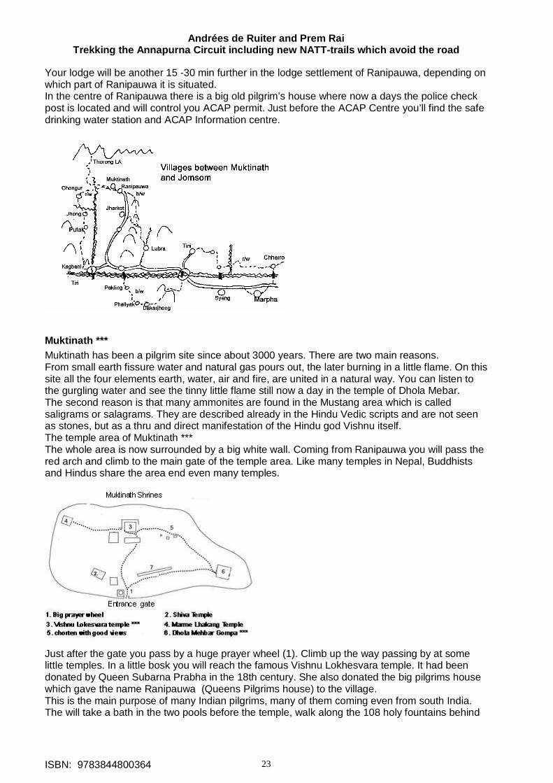
Andrées de Ruiter and Prem Rai Trekking the Annapurna Circuit including new NATT-trails which avoid the road
ISBN: 9783844800364 23
Your lodge will be another 15 -30 min further in the lodge settlement of Ranipauwa, depending on which part of Ranipauwa it is situated. In the centre of Ranipauwa there is a big old pilgrim’s house where now a days the police check post is located and will control you ACAP permit. Just before the ACAP Centre you’ll find the safe drinking water station and ACAP Information centre.
Muktinath *** Muktinath has been a pilgrim site since about 3000 years. There are two main reasons. From small earth fissure water and natural gas pours out, the later burning in a little flame. On this site all the four elements earth, water, air and fire, are united in a natural way. You can listen to the gurgling water and see the tinny little flame still now a day in the temple of Dhola Mebar. The second reason is that many ammonites are found in the Mustang area which is called saligrams or salagrams. They are described already in the Hindu Vedic scripts and are not seen as stones, but as a thru and direct manifestation of the Hindu god Vishnu itself. The temple area of Muktinath *** The whole area is now surrounded by a big white wall. Coming from Ranipauwa you will pass the red arch and climb to the main gate of the temple area. Like many temples in Nepal, Buddhists and Hindus share the area end even many temples.
Just after the gate you pass by a huge prayer wheel (1). Climb up the way passing by at some little temples. In a little bosk you will reach the famous Vishnu Lokhesvara temple. It had been donated by Queen Subarna Prabha in the 18th century. She also donated the big pilgrims house which gave the name Ranipauwa (Queens Pilgrims house) to the village. This is the main purpose of many Indian pilgrims, many of them coming even from south India. The will take a bath in the two pools before the temple, walk along the 108 holy fountains behind
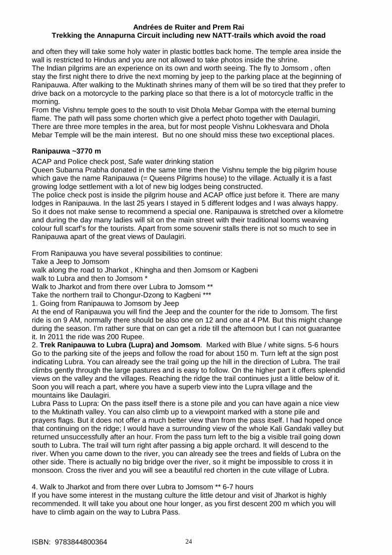
Andrées de Ruiter and Prem Rai Trekking the Annapurna Circuit including new NATT-trails which avoid the road
ISBN: 9783844800364 24
and often they will take some holy water in plastic bottles back home. The temple area inside the wall is restricted to Hindus and you are not allowed to take photos inside the shrine. The Indian pilgrims are an experience on its own and worth seeing. The fly to Jomsom , often stay the first night there to drive the next morning by jeep to the parking place at the beginning of Ranipauwa. After walking to the Muktinath shrines many of them will be so tired that they prefer to drive back on a motorcycle to the parking place so that there is a lot of motorcycle traffic in the morning. From the Vishnu temple goes to the south to visit Dhola Mebar Gompa with the eternal burning flame. The path will pass some chorten which give a perfect photo together with Daulagiri, There are three more temples in the area, but for most people Vishnu Lokhesvara and Dhola Mebar Temple will be the main interest. But no one should miss these two exceptional places.
Ranipauwa ~3770 m ACAP and Police check post, Safe water drinking station Queen Subarna Prabha donated in the same time then the Vishnu temple the big pilgrim house which gave the name Ranipauwa (= Queens Pilgrims house) to the village. Actually it is a fast growing lodge settlement with a lot of new big lodges being constructed. The police check post is inside the pilgrim house and ACAP office just before it. There are many lodges in Ranipauwa. In the last 25 years I stayed in 5 different lodges and I was always happy. So it does not make sense to recommend a special one. Ranipauwa is stretched over a kilometre and during the day many ladies will sit on the main street with their traditional looms weaving colour full scarf’s for the tourists. Apart from some souvenir stalls there is not so much to see in Ranipauwa apart of the great views of Daulagiri. From Ranipauwa you have several possibilities to continue: Take a Jeep to Jomsom walk along the road to Jharkot , Khingha and then Jomsom or Kagbeni walk to Lubra and then to Jomsom * Walk to Jharkot and from there over Lubra to Jomsom ** Take the northern trail to Chongur-Dzong to Kagbeni *** 1. Going from Ranipauwa to Jomsom by Jeep At the end of Ranipauwa you will find the Jeep and the counter for the ride to Jomsom. The first ride is on 9 AM, normally there should be also one on 12 and one at 4 PM. But this might change during the season. I’m rather sure that on can get a ride till the afternoon but I can not guarantee it. In 2011 the ride was 200 Rupee. 2. Trek Ranipauwa to Lubra (Lupra) and Jomsom. Marked with Blue / white signs. 5-6 hours Go to the parking site of the jeeps and follow the road for about 150 m. Turn left at the sign post indicating Lubra. You can already see the trail going up the hill in the direction of Lubra. The trail climbs gently through the large pastures and is easy to follow. On the higher part it offers splendid views on the valley and the villages. Reaching the ridge the trail continues just a little below of it. Soon you will reach a part, where you have a superb view into the Lupra village and the mountains like Daulagiri. Lubra Pass to Lupra: On the pass itself there is a stone pile and you can have again a nice view to the Muktinath valley. You can also climb up to a viewpoint marked with a stone pile and prayers flags. But it does not offer a much better view than from the pass itself. I had hoped once that continuing on the ridge; I would have a surrounding view of the whole Kali Gandaki valley but returned unsuccessfully after an hour. From the pass turn left to the big a visible trail going down south to Lubra. The trail will turn right after passing a big apple orchard. It will descend to the river. When you came down to the river, you can already see the trees and fields of Lubra on the other side. There is actually no big bridge over the river, so it might be impossible to cross it in monsoon. Cross the river and you will see a beautiful red chorten in the cute village of Lubra. 4. Walk to Jharkot and from there over Lubra to Jomsom ** 6-7 hours If you have some interest in the mustang culture the little detour and visit of Jharkot is highly recommended. It will take you about one hour longer, as you first descent 200 m which you will have to climb again on the way to Lubra Pass.
Andrées de Ruiter and Prem Rai Trekking the Annapurna Circuit including new NATT-trails which avoid the road
ISBN: 9783844800364 25
Jharkot ** This beautiful and interesting traditional village is situated 200 m below Ranipauwa. In the old days a huge fort was in the middle of the village, but there are now a days only some ruins remaining from it. Coming down from Ranipauwa you see the village stretched out on a ridge which is extending into the main valley. Take the direct trail straight at the end of the village. When you reach Jharkot cross a little meadow and enter the village on the left side. You will soon come to a long prayer wheel wall, which you should pass on the left side, and a beautiful old stupa. Many trekkers just by pass this extraordinary beautiful village, probably because they just started 20 min ago, but they miss a very interesting place. Take about 20 min for a sight seeing tour and you will not regret it! The Jharkot sight seeing tour ** Pass the long Prayer wheel wall and continue on this lane till the trail is going down to the left at the German bakery. Continue straight for about 20 m and turn then right to the entrance arch and the two protector statues which clearly ;-) are recognizable as a man and a woman. Pass the arch and then turn another ~20 m later to the left into a sort of tunnel below the houses. Continue after the tunnel for ~100m along the white houses of Jharkot. Sometimes you will see a protecting ghost trap. Bad spirits don’t like right angels and the ghost traps a made with many wool threads winded up exactly in this way. So they will not dare to come near this door a leave the inhabitants unharmed. After a while the lane turns up to the right and after a few house a lane is leading to the left to the monastery of Jharkot. This Gompa is absolutely worth visiting. If you have a cold or some other health problems ask on the Gompa premises if the Amchi is there. An Amchi is a Tibetan monk doctor. Often they can threat you very well with local medicinal plants so it is absolutely worth a try! After visiting the Gompa (or just the courtyard) return to the main trail and turn left going up to the corner, where you have a beautiful view on the valley. Pass the village on the north side below the houses. You will come across a new big wall supporting the newly built big village hall. Soon you will see a lane going up to the right. Take this lane and you will reach the central part of old Jharkot with old flat roofed houses. Continue finding a way a little bit on the left side and you will descend down to the main trail which you join near the prayer wheel wall. Jharkot to Lubra (With Blue /white NATT signs till Lubra Pass) You can see the trail going up to Lubra Pass from Jharkot on the opposite hill side. The trail going to Lubra starts at the beginning of the big prayer wheel wall and turns at the fountain to the left (south). Follow the general direction. Going along some houses and you will reach the road but leave it again after may be 40 meters. Continue in the general direction. The trail leads you through fields and pastures. On the right you will see a little village with four houses. Finally you come to a large pasture where you just follow the electric lines till you reach some former governmental bungalows. Continue here to a door in a stone wall which surrounds the fields. After the door go along the wall on the outer side till you are under a little white stupa. Continue for ~ 50 m till you see the trail going up diagonal on the left. This trial leads up to the Lupra Pass. Lubra Pass to Lupra: On the pass it self there is a stone pile and you can have again a nice view to the Muktinath valley. You can also climb up to a viewpoint marked with a stone pile and prayers flags. But it does not offer a much better view than from the pass itself. I had hoped once that continuing on the ridge; I would have a surrounding view of the whole Kali Gandaki valley but returned unsuccessfully after an hour. From the pass turn left to the big a visible trail going down south to Lubra. The trail will turn right after passing a big apple orchard. It will descend to the river. When you came down to the river, you can already see the trees and fields of Lubra on the other side. There is actually no big bridge over the river, so it might be impossible to cross it in monsoon. Cross the river and you will see a beautiful red chorten in the cute village of Lubra. Jharkot** to Lubra** (With Blue /white NATT signs till Lubra Pass) You can see the trail going up to Lubra Pass from Jharkot on the opposite hill side. The trail going to Lubra starts at the beginning of the big prayer wheel wall and turns at the fountain to the left (south). Follow the general direction. Going along some houses and you will reach the road but leave it again after maybe 40 meters. Continue in the general direction. The trail leads you through fields and pastures. On the right you will see a little village with four houses. Finally you come to a large pasture where you just follow the electric lines till you reach some former governmental bungalows. Continue here to a door in a stone wall which surrounds the fields.
Andrées de Ruiter and Prem Rai Trekking the Annapurna Circuit including new NATT-trails which avoid the road
ISBN: 9783844800364 26
After the door go along the wall on the outer side till you are under a little white stupa. Continue for ~ 50 m till you see the trail going up diagonal on the left. This trail leads up to the Lupra Pass. Lubra Pass to Lupra: On the pass it self there is a stone pile and you can have again a nice view to the Muktinath valley. You can also climb up to a viewpoint marked with a stone pile and prayers flags. But it does not offer a much better view than from the pass itself. I had hoped once that continuing on the ridge; I would have a surrounding view of the whole Kali Gandaki valley but returned unsuccessfully after an hour. From the pass turn left to the big a visible trail going down south to Lubra. The trail will turn right after passing a big apple orchard. It will descend to the river. When you came down to the river, you can already see the trees and fields of Lubra on the other side. There is actually no big bridge over the river, so it might be impossible to cross it in monsoon. Cross the river and you will see a beautiful red chorten in the cute village of Lubra.
Lubra ** (also Lupra) This cute little village is special interest as it has a Bonpa-Monastery. The Bon religion supposed to be more similar to the ancient religion of Tibet and had greatly influenced the Tibetan Buddhism especially with many shamanistic traditions. But in the same time also the Tibetan Buddhism influenced the Bon Religion mainly with its philosophy. Even when the Tibetan Buddhism was state religion in Tibet the Bonpa remained practising. In 1977 the Bon Religion was admitted by the Dalai Lama as a regular line of Buddhism. There is one visible difference: While the normal Buddhist always turns the prayer wheels clockwise, the Bonpa do it anticlockwise. The Gompa of Lubra is absolutely worth visiting, ask in the village for the person who have the keys and don’t forget to give a donation and a tip. Typical for Bonpa is the use of blue colour so many of the statues have blue hats. This is the only Bon Gompa in this region but further up in the west Dolpo is mainly Bonpa land, probably the most authentic Bon area since the Chinese invaded Tibet and destroyed the Buddhist and Bon monasteries and killed many monks and nuns. Lubra is a very small village so you can explore it in a few minutes. The hillside consists of coarse-grained absolutely black sand. You might climb up the hill to a new little temple but it is rather hard and I would not do it a second time.
Lubra to Jomsom 2 hours Walk around long 45 min till along the riverbed till you reach the main Kali Gandaki Valley. In the afternoon you will have a stormy wind blowing sand and little pebbles in right into you face. Muktinath -Ranipauwa to Kagbeni *** 5-7 hours red/white NATT marks This trail is one of the highlight of AC and one of my favourite days and areas. If there is a possibility to do it you should! The trail on the northern side of Muktinath valley offers awful views on the mountain range of Nilgiri and Daulagiri and YES! You can see perfectly the Thorong la on the way!!! This beautiful trail passes through the very nice Tibetan stile villages of Chongur, Jhong and Putak. Although it is following on a long part a little dirt road, it doesn’t matter really, as this road in nearly not used, there are rarely more than 5-10 vehicles in a whole day. This road is often barred by a land slide and then it is only for you. The trail to Kagbeni starts just below the red arch, marking the way to the Muktinath Gompa in Ranipauwa an goes first to Chongur, a village which you can already see from Ranipauwa. The ACAP signposts written as Tyonkhar but every local people call it definitively Chongur. Follow the trail to the little micro electric power station, which formerly produced the electricity for Muktinath Ranipauwa, which is now coming through the Kali Gandaki grid. Continue till the road and cross the river on a bridge. Follow the road around~200m till the road turns to the right and a large foot trail is continuing straight to the beautiful village of Chongur.
Andrées de Ruiter and Prem Rai Trekking the Annapurna Circuit including new NATT-trails which avoid the road
ISBN: 9783844800364 27
Chongur ** Directly on the beginning of Chongur there is a beautiful Gompa**. Ask around if someone has a key, if you would like to visit. The Gompa was founded by a Sakia-monk and the whole village is painted with the colours of Sakia giving it a very particular and beautiful atmosphere. Continue through this picturesque village and turn to the right at the end of the village round a Mani wall. Follow the signpost and climb up. After turning on the top to the left you come to a viewpoint with chorten and you see already the bridge bellow. Cross the bridge and join the road. It will lead you along a grey house which is the school of Jhong.
Jhong ** (also Dzong) You will enter Jhong by the north east. Descend the main road with several Mani walls and chorten. Right on the beginning at the left there is one of the two lodges called Dhakpochhe Tashi-ling Guest House and Restaurant. It has 8 beds 'I you want stay here; check first the mattresses, as the didi like rather hard ones. On the bottom turn to the right in direction of the ruins of the former Jhong fortress which gave the name to this village. Before continuing to Kagbeni, climb up the trail going up to the famous monastery. First you will pass Jhong viewpoint top or Thorong la viewpoint top Guest house F from its dining hall you have a splendid view on Thorong La and the area around Muktinath. They have also a few beds. Up on the ridge, visit the Gompa. It is one of the few Gompas, where permanently several monks are living. You have to pay some entrance fee but it is absolutely worth and the view from the roof is absolutely fantastic. You have a surrounding view of Thorong la and its mountain range with Khatung and Yakawa Kang, Tilicho peak and the Nilgiri, Daulagiri, Tukuche peak and the mountains west of the valley. Jhong ** to Putak* To continue go down again to the road bellow the ruins and head down. After 20-30 min you see the old village of Putak. Just before the village, take the small path going down near an electric pole. After the Mani wall continue above the village houses and then turn down left to go down into the village. On the main street turn right again and leave Putak through the western gate. The trail down is surrounded by trees and continues along fields. Later the trail passes above the long wall protecting the fields of Putak. Take care, there is a junction where the main trail seams to continue along the wall down, but you will have to go a little up to the right. Around the turn you can already seen the trail going up on the right hillside and a small suspension bridge over looking a deep ravine which you will cross. Climb up the trail to a stone pile and you reach again the road. Follow it about two hours till you can see the Kali Gandaki River near Kagbeni. At the end of the ridge you can see a Stupa which is one of the best view points in the valley. Watch out for an electric pole with red/white marks and continue to the stupa. From there you have a breathtaking view over Kagbeni and the Kali Gandaki River and into Upper Mustang, there are to possible trails leading down from the stupa to Kagbeni, Both are a little bit difficult but not dangerous. One is leading down on the right side of the stupa with perfect view on the valley. The other one is going down through a narrow and spectacular gorge. Both ways join again above the road; go down and take the shortcut to the northern end of Kagbeni and enter it along the long prayer wheel wall. If you are very tired or don’t want to take difficult trails, skip the detour to the stupa and just continue on the road till Kagbeni. Notice: One is not allowed to go north of the Muktinath - Kagbeni road, as it is the restricted area of upper Mustang. The fine against entering illegally to the restricted area can be very high. AC clockwise: Going up from Kagbeni to Muktinath. Red/white marks If you are going up from Kagbeni, it makes sense to stay in Jhong as it is a little bit lower than Ranipauwa so you have fewer problems with altitude. Go to the north of Kagbeni and leave it along the long prayer wheel wall. Just ahead you will see a stupa high above the ridge. Climb up from the road. After a short ascend, there are two possibilities. The left path is going on the river side, the right one climbs up through a spectacular
Andrées de Ruiter and Prem Rai Trekking the Annapurna Circuit including new NATT-trails which avoid the road
ISBN: 9783844800364 28
gorge. The stupa is a fantastic viewpoint. Continue from the stupa in the direction of the road and follow the road for about 2 to 2, 5 hours. Watch out carefully till you see on the right side some marked rocks leading to a stone pile. Descent to a small suspension bridge going over a deep ravine and continue along a long stone wall protecting the fields of Putak. Finally you will climb up a trail with trees till you enter the gate of Putak. Putak is a lovely little village in the style of upper Kali Gandaki resembling already Tibetan villages. You will reach on the "main" road the centre of this village. There you have to turn to the left and climb, leaving the village above the houses. After passing a Mani wall you climb up to the road which you follow till the next village of Jhong with the ruins of an old fort (Dzong) which gave the village its name. Jhong has a beautiful Gompa** which you should not miss and from its roof you have one of the best views on the Muktinath valley, the mountains and the Thorong La. To go there take the path climbing up to the ridge. On the way up you first come across former Milan lodge which may now be named Jhong Viewpoint top or Thorong la viewpoint top. From their dinning hall you have an excellent view of Thorong la and the village. If you would like to stay her, ask someone to call them in the morning to see if they have free rooms left (mob. 9746715799 or 9847670320) there are only 8 beds. Continue by going back and then taking the Jhong Avenue on the left with many Mani wall and chorten. On the end, just take again the road. Passing a grey school you will soon see on the right side high above a ridge some houses of the village of Chongur. To go there take the trail to the suspension bridge. After crossing it, don’t follow the signpost to Muktinath but take the trail to the right, and reach a chorten. Turn to the left and go down to Chongur where many houses are painted in the tradition of Buddhist Sakia sect. Continue at the end of the village and soon you will see the houses of Muktinath Ranipauwa . My love Kagbeni 2800m (safe water drinking station, ACAP office) Kagbeni is an absolutely magic place and no one should miss the opportunity to see it. I have met many trekkers who first did not plan to go there and then decided to stay two days because it was so beautiful. It is my favourite village in all the Annapurna area. Kagbeni is situated at the confluence of the Jhong River and the Kali Gandaki River and was controlling the trade to upper Mustang and Tibet. You still can see this aspect in the old village centre, which looks rather like a fortress. Visiting it, you will feel like being I former medieval times passing trough the narrow lanes or tunnels between old mud houses. Kagbeni has many fields which are irrigated by the Jhong River coming down from Muktinath and flowing through the middle of the village. The northern part is formed by an enclosed village part with only three entrances. When you are coming from the river you will see the entrance on the right side below the Red House Lodge. Enter the small lane and go till the end where you turn right. On the north side you see a very long prayer wheel wall. Always walk on the left side. At the end you have a good view into Upper Mustang and you can see well the village of Tiri a little bit above the river. Here is also the starting point, if you want to go up to Jhong and Muktinath. In August 2011 a signboard still stated that it is forbidden to go further without the special upper Mustang Trekking Permit. This is wrong! You are definitively allowed to go up the road to Jhong and Muktinath, to make day trip to the village of Tiri and to climb up to the Sher Dhak viewpoint on the other riverside. Going back (again on the left side) you will pass the ACAP office. At the end of the prayer wheel wall continue ahead and you come to the old protector of Kagbeni. To show potential bad spirits that he is really a strong man is well they left no doubt about his sex. I call this statue is the Mr. Viagra man. Continue through some tunnels to the little central place. Above it, one can still see the ruins of the former Dzong of Kagbeni. Take the west lane at the end of the place and you will reach the third entrance. Near to it there is the counterpart of the Viagra men, a very clear woman statue. The lane leads to the Kagchode Thubten Samphelling Gompa. You will have to pay an entrance fee but it is well worth to do so as it is a nice Gompa. Some people are just happy to take some photos from the roof with it fantastic views. Have a look at the cute little wind mill prayer wheels. Return from the Gompa to the river and cross it. Going down you come to the jeep parking station and the long suspension bridge. On the other riverside the trail will go to Tiri and the view point. But even if you don’t want to go there, it is worth to cross the bridge and go about 100 m north.
Andrées de Ruiter and Prem Rai Trekking the Annapurna Circuit including new NATT-trails which avoid the road
ISBN: 9783844800364 29
From there you have a splendid view of Kagbeni above the cliffs and in the background Thorong La!!! The best time for a photo is in the late afternoon. On the south side of the river is the more open part of Kagbeni. From the little bridge Kagbeni’s shopping street will bring you to an old and beautiful old stupa. Continue later on this way to reach Jomsom. Lodges: There are several lodges in Kagbeni so that you always should find a place to stay. Normally I don’t recommend lodges, but for Kagbeni I make an exception: Near the entrance to the old village you find the Red house Lodge. This is very old house has a private prayer room with an old Buddhist statue and offers a beautiful view over old Kagbeni. If you like basic lodges have a look to the Star Lodge aside the prayer wheel wall. In this old style house there are three basic rooms and the didi has a beautiful smile. There is no solar shower but you have a great view on the village from the roof. The third recommendation is for the Annapurna lodge on the south end of the village. This newly built lodge with spacious rooms offers some special menu unique on the whole trek. If you stay there try sesame potatoes or their cabbage roll with béchamel sauce. It’s delicious. But to be clear, the other lodges are also a very good place to stay and I never heard any complaint. Side treks
Tiri 2800 m About 30 min north of Kagbeni lays the little village of Tiri on the western bank of Kali Gandaki. Till some years it was in the restricted area and the access forbidden, but now you are allowed to go there during the day time which is one of the highlights of the new AC. Tiri lays on a fertile stretch of soil reaching out to the Kali Gandaki riverbed. In the dry season you simply cross the river going down from the long prayer wheel wall at the north end of Kagbeni on some little temporarily wooden bridges. Climb up on the other river bank to the road which is clearly visible. This road will continue above the wall, which protects the fields of the village. When there is too much water to cross over Kali Gandaki on foot, then you can cross it on the suspension bridge of Kagbeni. At the end, you can turn to the right to enter the village. After 100m, there is a little place with two fountains. Take the tunnel on the left which leads you to the northern part. On the right side of the place there is a red house containing a huge prayer wheel. Just afterwards is the Norling restaurant in a classical mustang house. The didi grew up in the Annapurna lodge of Kagbeni and she has married to a man of Tiri village. She will gladly serve you tea or some food. On the way back, just continue on the lane, climb over a little wall at the end and find a trail through the fields. The Samdup Choeding Monastery ** in Tiri This beautiful Gompa is perched high above Tiri. It was built around 860 Years ago when lama Lungzin Palsang had a dream seeing Lord Buddha which told him to built a Monastery on a place where there is a rock in human hearth form. After long searching he found the place above Tiri. It was one of the oldest Gompas in this area but had been destroyed by fire. After being rebuilt many monks and nuns practiced there but after a time, all monks and nuns had left and the Gompa was left alone. In 1986 the monk Lama Dukta from Dolpo started visiting the Gompa and performed many pujas. He was asked by the people of Tiri to stay there and accepted. Together they started to rebuild the monastery. Lama Dukta is also an Amchi, thus a Buddhist monk doctor, practicing Tibetan medicine. Ho to go there: A trail is going up near some big chorten. As you see the Gompa above Tiri you will easily find it. From above you have a great view into Mustang but also on Kagbeni with the Nilgiri. I highly recommend this side trek! When you are above, try to find someone with the keys for the Gompa and also ask to see the well sorted pharmacy. Lama Dukta is collecting himself many of the medicines himself but also exchanges some with other Amchis or buys them in Kathmandu. It’s very impressive to see the hundreds of glasses full of smelling plants, minerals or dried insects. Going from Kagbeni to Jomsom
Andrées de Ruiter and Prem Rai Trekking the Annapurna Circuit including new NATT-trails which avoid the road
ISBN: 9783844800364 30
If you are heading to Jomsom you can either take the 2, 5 hrs, long way along the barren valley of Kali Gandaki or take the high route by Phalyak with offers spectacular views on the mountain and picturesque villages, but take between 6 - 8 hrs. I must say it was one of the most beautiful trekking days on AC when I first walked it in 2011.
Kagbeni - Jomsom standard route 2, 5 hrs In this part of the valley of Kali Gandaki you will face a very strong wind up the valley every day starting from 10 -11 AM and increasing till the late afternoon to a really storm. So you should start latest at 8 AM in Kagbeni. After 12 AM the wind could grow to a storm, not only blowing sand from the dry riverbed on your face, but even little stones. And it is very hard and exhausting to walk against the wind. Take the southern end of Kagbeni and leave along the scarcely used road Kagbeni. After 20 min you can descend to the right on a nicer trail (red/white marks) on which you will reach Eklebhatti. Eklebhatti is a small settlement of 4 lodges including the Hilton hotel! Short after Eklebhatti there is a long suspension bridge over spanning Kali Gandaki leading to the villages of Pakling, Phallyak and Dhakarjhong. Continue on the road till you reach old Jomsom, where the jeep parking station welcoming you. Going through a small lane with shops, restaurants and some lodges you reach the first wooden bridge over KG. Just before the bridge, a signpost is pointing to Thini, the next destination of NATT trail on the way to Marpha. If you start in the morning you can reach Marpha on the NATT trail in the afternoon. High route from Kagbeni to Jomsom ** (blue /white marks) This beautiful but arduous trek starts at the bridge of Eklebhatti. Follow the trail going up. When you reach the village Pakling make a little tour through it. You will be astonished how large the fields are. The huge agricultural area lies on large terrace which you can not see from the road below, where it only looks like a barren and arid hill slope. A signpost "Phalyak" will guide you again up to the road. Follow this road up and you will reach the long wall protecting the fields of Phalyak. Contouring it on the left you will see a large chorten above you on the right. This is the entrance of Phalyak. Right on the beginning of a little plaza you can ask in the big white house on the right for cold drinks or food. Phalyak is a beautiful village where you can see already a little the influence and style of Dolpo and it is worth wandering around for a while and take beautiful photos. We ordered Dhal bhat and I was happy to have to wait 45 min so I had plenty of time to walk around. It is such difference to be in an authentic village rather than in lodge settlements. To continue take the lane going up on the left end of the place. A picturesque lane will trigger you photo - desires until you reach the old little Gompa. Here you have to turn left, but you could do some more sight seeing going up the lane ahead in direction of Dolpo and return to the Gompa. Near the Gompa pass under a house in one of these typical tunnels so common in this windy area. Coming out of this tunnel you already see across the little river side the village of Dhakarjhong. Walk down to the river and climb again the hill to reach it. Watch out on the left for another tunnel which leads you to a very small lane. Turn right there and climb up the trail till you reach a little pond with a chorten in the middle. Behind this pond there are more of the houses of Dhakarjhong. Just a little bit further of the pond turn to the left into a lane between houses in direction of the telecommunication tower on the ridge, it is a steady and long ascent. On the very windy pass Batase Bhanjyang 3435 m (Windy pass) one has a superb view from the left Upper Mustang, Thorong La, Tilicho peak, the Nilgiri, Daulagiri and Tukuche peak. When we were there, we had wind of 7 beau fort, and my glasses flew directly away. But we stayed there for half an hour having much fun in the storm. Continue straight ahead on a descending trail that will be soon very clear. It will take you about 2, 5 exhausting hours to reach Jomsom on the right side of the river. Jomsom 2720 m Old Jomsom (Jeeps to Muktinath) Jomsom is located on both sides of Kali Gandaki. Coming from Kagbeni you will first enter on to old Jomsom. Most people will not even realize how big old Jomsom is as they will continue along the lane leading to the bridge and passing already several shops and some restaurants and lodges. In fact old Jomsom is not that really interesting so you will not miss a lot. Old Jomsom ends near the northern wooden bridge. Further south on this riverside you will find many governmental offices, as Jomsom is the head quarter of Mustang district. There are two basic
Andrées de Ruiter and Prem Rai Trekking the Annapurna Circuit including new NATT-trails which avoid the road
ISBN: 9783844800364 31
lodges just near the bridge, in one of them Jimmy Hendrix stayed once. It is there that the NATT- trail continues to Thini and Marpha. If you don’t have to do things in New Jomsom, you can just stay on this side. New Jomsom (ACAP office, Police check post, safe drinking water station, internet, airport) Crossing the Kali Gandaki wooden bridge you are on the Bus station where the buses down to Ghasa and Tatopani depart. There is own bus starting at 9 AM and others when there are enough passengers during the day. New Jomsom has a big military training centre and many hotels were built near the airport. Many people take the plane to go or leave from here. Because of the strong winds flight are often cancelled so it is wise and good for the nerves to have always at least three days in reserve. If one is only trekking in the Mustang area it’s better to take the flight to Jomsom and walk back as you can control much better your time schedule, but now a days one can also reach Pokhara from Jomsom in two days by bus. All companies flying Pokhara to Jomsom have an office in Jomsom. There is no flight Jomsom to other destinations like Kathmandu. one is only trekking in the Mustang it’s better to take the flight to Jomsom and walk back as you can control much better your time schedule. New Jomsom benefits a lot from the growing Indian pilgrim tourism. They fly in, go the next to Muktinath by jeep and return to Jomsom. As flights are very often cancelled this means additional days staying in the lodges. Hoteliers like it very much and earn a lot of money. They like very much Indian tourist as these are coming all over the year and not only in the peak trekking season. At the south end of New Jomsom you find the Mustang Eco Museum and a 5 star Hotel with it own swimming pool.
Jomsom to Marpha by road 1-1, 5 hrs If you are in a hurry, you can reach Marpha in about 1, 5 hrs. Depending on the riverbed after the monsoon you might also be able to walk below the road on the riverbed but this will be rather windy and dusty. Jomsom to Marpha by the new NATT- trail over Thini and Dhumba lake** (red/white marks) 2, 5 to 3 hrs This trek is very nice and will lead you through the nice Thakali village of Thini and wonder full juniper and pine forest with good view of the Daulagiri and other mountains. Start from the left side of Kali Gandaki in Old Jomsom just opposite the northern wooden bridge and take the stairs beside the Annapurna lodge. Follow the lane and you will walk on a gravel road above the fields of Jomsom protected by a long wall. When the road start to climb up the hill, look out for a trail going down near the wall and continue. At a junction take the left trail heading left and soon you will see the white painted houses of Thini. Climb up the village, the red white marks may be a help. You will have to leave Thini by the west at a big chorten. From above you will see the bridge. Cross it and continue on the trail. Turning around the rocks you will see some houses. Climb up and you reach to Dhumba Lake with fishes in. After Dhumba Lake take the left trail and climb up to the ridge. After the windy ridge you will first pass through a prayer wheel gate and descent to the direction of Kali Gandaki in the side valley. In the next village Dhumba, turn to the left land go down to the riverbed of the side river. Already you can clearly see on the other side a bigger trail and many smaller ones, which make it a little bit confusing going up. Be aware that many of the trails will go straight up to the forest to collect wood. The trail to Marpha is contouring the hill above the cliffs high over the KG and offers splendid views of the valley and Marpha. At a place with some prayer flags overlooking Marpha you will start a long descent. Finally you will reach the former Tibetan refugee camp at Chhairo, where still many Tibetan are living. At the end of this village a new lodge and restaurant with 14 beds is being built. It might be a very good idea to stay there and to visit beautiful Marpha without carrying your heavy bag pack. It would also save your time for the next morning about 20 min walking. From Chhairo a path is going to a suspension bridge. After this Bridge, you have to go back for around 20 min to the centre of Marpha, but only the half of it is on the road, as the motor road
Andrées de Ruiter and Prem Rai Trekking the Annapurna Circuit including new NATT-trails which avoid the road
ISBN: 9783844800364 32
contours the old village of Marpha. Quite a few trekkers dump their bag pack already in one of the lodges before Marpha along the road and return after a visit to Marpha. Marpha *** (internet, safe drinking water station, money changer) Marpha is one of the places should not miss and you could have some very nice hours exploring it. So don’t mind if you arrive already at 3 - 4 PM and enjoy it. All the houses are painted with bright white colour and the lanes are paved with spotless clean stone plates. Marpha is the centre of the apple growing area and an agricultural research centre of Marpha that the apple story has began. Now you will find apples in all possible forms: Fresh apples, apple pies, apple cider, dried apples or apple brandy and apricot items as well. Most lodges will offer you at least two different apple pies and some more cakes during trekking season. The lodges of Marpha are excellent; most of them are inside old and large Thakali houses. It is just a pleasure to stay there. The big Gompa was renovated and enlarged in 1996 and it is worth a visit. Above it is a new meditation centre with some hermitage cells behind it. You can walk to the huge natural stone chorten overlooking the village, from where you have a wonderful view. Marpha - (Tukuche) - Kokhethanti partially marked with red/white signs 8 hours This is a very long journey. You can make a stop in the beautiful Thakali village of Tukuche and walk the rest of the day on the road, but you should take this trail even when you want to go there. This part of the New Annapurna Trekking Trail was completely rebuilt by ACAP which constructed a perfect trail with breathtaking views of Daulagiri through a nice pine and juniper forest. The new trail is much better than the old one which is now the road. The trail starts at the bridge some 20 min south of Marpha leading to the Tibetan settlement of Chhairo. Go till there and turn to the right through a small forest and you will join a trail going south. After passing the ruins of the former Tibetan refugee camp you will reach the house of lower Chhairo with a school and old stupa. At the end of the village turn to the left and follow the trail along the main valley. You will come to a junction where the trail divides going left to the little but rewarding detour to Chimang and on the right directly to Chokhopani, which means clean water. If you are in a hurry you can take the short cut to Chokopani, which will take you around 45 min. Chimang Far more rewarding is the trail over the village of Chimang. The trail will lead you to some pastures below cliffs, as Chimang is situated on a plateau 100 m above the valley. Climb up in the romantic gorge, at the division take the right stairs and you will reach the fields and apple orchards of Chimang with a beautiful view on Daulagiri, Tukuche peak and the lower Mustang valley. Every meter you have to climb and every drop of sweat is definitively worth this side trip. Before the entrance door there are three huge Tibetan stile ladders, as the people of Chimang keep the door closed, avoiding that their cattle roams into the fields. There is a possibility to cross the lower part of the village and descent by a long staircase but the village is particular and very beautiful so it is advisable to go up till the end and go down by a scarcely used road. In the middle you will find Chimang Hotel and Restaurant with 11 basic beds. On the top of the village turn right and descend along the road. After you have already passed the village you can leave the road in a turn by just continuing straight on a larger trail. After a small wooden bridge about 80 m further you can descend to the river on a very idyllic path meandering down in the forest. Below cross the road and later the river on a bridge and continue on the other (south) side of the river. Continue the trail which will enter the main Kali Gandaki valley. Soon you will see on the other riverside a huge Buddhist painting on the rock wall. Shortly after a suspension bride over stretch the Kali Gandaki. After crossing it will take you about 30 min on the road to Tukuche In the dry season (normally end October / November to May you also can cross to Tukuche on wooden planks, which will serve as small bridges over the many then small arms of Kali Gandaki just after Chokhopani. Continue on the marked trail, taking care not to enter the military area on the right but take the left passing by a small Ganesh shrine. After crossing a very large area, where the river deposits every year new rocks and pebbles you can see the few houses of Chokhopani three trails going up the mountain, yours will be the lower one on the right.
Andrées de Ruiter and Prem Rai Trekking the Annapurna Circuit including new NATT-trails which avoid the road
ISBN: 9783844800364 33
Enter Chokhopani 2585m, this means clear water, and turn right the village lane. There is one basic restaurant where you should eat if you don’t want to cross to Tukuche. Descend down near by the river. In the dry season there will be small wooden planks acting as bridges so that you can cross to Tukuche
Tukuche Have lunch in Tukuche or just make a sight seeing tour to this old Thakali village. Tukuche has been the toll place for the salt trade with Tibet and still you see the large houses used as caravanserai. On the ground floor there was place for the animals and goods while the people were staying on the first floor. One can evaluate the wealth of Tukuche looking at the beautiful carved wooden windows. There are several newer lodges north of the old village centre along the road, which fortunately bypasses the old part. Inside the village you will some more. As Marpha Tukuche is apple country so enjoy the tasty pies! On the southern end near the river is the Tukuche Brandy distillery. I learned that they don’t distil the apple brandy from fermented pure apple juice but use a lot of sugar where they add some apples. Normally there are wooden planks over Kali Gandaki River on the northern and southern end of Tukuche. So you can pass Tukuche and cross the river on the south end and rejoin somewhere the main trail again If you want to continue without crossing Kali Gandaki and by passing Tukuche you will have to climb some 200m to the little pass above the high cliffs..
Chokhopani to Sauru (2-2,5 hrs) If you want to continue without crossing Kali Gandaki and skip Tukuche you will have to climb some 200m to the little pass above the high cliffs. Climb up the trail beginning near by the river. It will lead you through a delicious smelling lush pine and juniper forest with full of birds’ habitat. Quite often you can see the Dhaulagiri in all its splendour peeping through the trees, be sure to have enough memory in your camera left ;-) you will surely need it. This trail was newly constructed by ACAP and is just perfect! The top of the trail is a 2785m, and then it descends in a long trail to finally reach the village of Sauru. Sauru has some stone houses on the hill slope but also several wooden huts in the plain of the river delta. In the season you should get some tea and I was told that one of the new buildings will be a lodge. Not so bad because there are still 2, 5 hrs to walk till Kokhethanti. Sauru to Sirkung and Kokhethanti (this part of the trail is not marked) 2, 5 - 3 hrs From Sauru continue walking south crossing a little side river. This part has just been newly fixed by ACAP; in August 2011 it was very difficult. After some time, the trail changes to a bigger road like trail made by bulldozer leading first to some houses of Sirkung and then further in direction of Kokhethanti. This Road like trail, which is not in use for traffic will pass near the bridge over Kali Gandaki leading to Landrung on the other riverside then in 10 min to Kokhethanti . Kokhethanti 2500m has 3 basic lodges. From Kokhethanti you can continue climbing up to Dhamphu and then reach Kalopani in around 40 min. Kalopani has better lodges but the road is passing through. So it’s your decision what you prefer. Kokhethanti - Titi Lake, Taglung - Kalopani 5 - 6 hrs red / white marks If you have enough time, this day round trip is highly recommended, as it will bring you to beautiful surroundings, nearly looking like the Alps with pastures and a great view on Nilgiri. Start just 100m after the end of Kokhethanti and turn to left and take the road up. Even when it's a road there is rarely any vehicle using it, so you can walk up enjoying the beautiful pine forest giving you shadow in the morning. In Germany we would call this a quiet "Waldweg" or forest trail. The top of this trail is at 2700m thus 200m higher than Kokhethanti. Descending with some minor up and downs you'll find the village Titigaon on the left side at 2675m. There is the new Titi Guest House with 14 beds. Just pass the village and you will see Titi Lake, which should rather be called Titi Pond, as it is rather small. According to the ACAP Board, it’s categorized as an important marsh zone for the water birds in Mustang.
Andrées de Ruiter and Prem Rai Trekking the Annapurna Circuit including new NATT-trails which avoid the road
ISBN: 9783844800364 34
It takes you around 2 hrs from Kokhethanti to reach Titi Lake. Around 25 min later, you reach a pasture with three chorten, piled up with grey stones. Short after the trail to Taglung is going down on the left side. At the end of Taglung turn right and descend to the school and the villages of Kunjo. The Didi of Sangam Hotel has a hart full and large smile and cooks an excellent Dal bhat. After going down the village turn to the left after the ACAP signboard. The road will bring you down to the white shining riverbed of the Bhuttro Khola which is coming down from the Nilgiri. Go through the village of Chhoyo and cross later Kali Gandaki on a huge suspension bridge. After the bridge turn to the right and keep right. Follow the trail with red/white marks. Climbing up a little bit and you will come to a fully coloured rock. The situation in Kalopani is a little confused. The two villages, Lete in the south and Kalopani in the north are stretched over 3 km and are just separated by some fields. Unfortunately the motor road is going right through these to villages, Therefore ACAP built a parallel NATT- trail around 100 -150 below the village and far away from the road noise. Several smaller trails connect the upper village parts and the lower trail. At the coloured rock you must decide where you want to go, turning left leads you to Ghasa in 3, 5 hrs, but only one lodge is on the way, If you want to continue the next day to Ghasa, Lete will be a good choice. The trail left of the coloured stone leads to south Lete with four Lodges, Turning to the right brings you to a second junction with the trail going to Lete or Kalopani. Kalopani is about 30 min further away and there are many lodges with good standard. Kalopani /Lete to Ghasa by a beautiful lush forest trail ** 4 hours Kalopani (safe drinking water station, museum) Kalopani is stretched along the road, which unfortunately goes through this village. There are many lodges, the first being Kalopani Guest house of Mr. Romy Gauchan Thakali, who is an influential politician for Nepali Congress and has even been Foreign Affair Minister. Going up the road you find many other lodges with a good standard. On of the best dal bhat I ever had was in Kalopani in the See You Lodge. Kalopani is a splendid place to see the mountains. It’s one of the very few places where you can see Annapurna I on the AC and definitively it is the best one. Already when crossing the bridge over the kali Gandaki you can see in the east the north face, with a few little peaks. The highest with 8091m is on the right side of the ridge. More on the south you see the Bharha Chuli /Fang and then Annapurna south. On the west you see directly the south east ridge of the Daulagiri 8167m. Enjoy the sunset on Annapurna chilling on your lodge and the sunrise on Daulagiri at breakfast. Make sure you see them both from the lodge you want to stay. You might also take the 30 min trip up to the viewpoint of Dhulu Danda, the trails starts near Kalopani Guest House Lete After the top of the road begins the village of Lete, just separated by some fields and also stretched along the road. In Lete you will also find several lodges but the view on the mountains is not so nice than in Kalopani. At the south end of Lete the road will turn to the left, but a large trail continues straight a head and you can climb down to the road on a steep trail which is a nice shortcut if you are already in Lete. The NATT- trail by passing Kalopani and Lete red /white marks I must admit the new NATT- trail is not so easy to describe and it is a little bit confusing. In fact it took us a whole morning to find a way for marking it. ACAP has constructed a really beautiful parallel trekking trail about 100 -150 m below the village avoiding completely the traffic. This trekking trail is linked to the main village road by several little trails so that you will have to choose on which exit you want to diverge to the trekking trail.
Andrées de Ruiter and Prem Rai Trekking the Annapurna Circuit including new NATT-trails which avoid the road
ISBN: 9783844800364 35
Coming from Kokhethanti / Dhamphu you climb up to Kalopani the cross the Kali Gandaki on a suspension bridge. The Kali Gandaki is here very narrow and the first time crossed it I did not realize at all that I was crossing the big Kali Gandaki thinking it was just a smaller side river. When you enter Kalopani you have several possibilities: 1. You just had Breakfast and need nothing from Kalopani/Lete: Then take the exit (I) to the left and enter the forest. Follow the red/white signs and you will avoid completely the village and the traffic. 2. You would like to stay over night in Kalopani and find a lodge just in the beginning. The Exit (II) is just behind the Kalopani Guest House right opposite of Angel Guest House. Enter the forest on a trail leading to a small house. Just before this house turn to the right and follow the marked trail. 3. Whether you want to get water from the safe drinking water station or want to stay in one of the many hotels further up. Take the Exit (III) on the top of the road but near the fountain, it will lead you again to the forest. 4. You can go further up to Lete, there is another trail going down near the police post. 5. You may even take another exit near the health post but then I would rather continue on the road and take the straight trail after the road turns left to descend. From the forest the parallel trail is passing through the fields with big walls and enter later some more open terrain. You reach a big stone with many writings, which I call the coloured stone. Continue by following the marks. After a tiny farm house the trail becomes a small path that turns right into a beautiful forest to join again the main road. At the junction follow the main road to the left. After some time you can see deep gorge below on the left a long suspension bridge over the Lete khola with the former Namaste Lodge. Don’t go down to this bridge, even when you remember that this was the old trail. Instead continue some 200m and cross the Lete River on the second suspension bridge. The road makes a long turn crossing the river some hundred metres further on the third bridge. The forest trail from Lete to Ghasa ** 4 hours red / white marks After crossing the river climb up the hill and when you reach the road cross it and continue climbing on a little path just a few meters more on the right. This beautiful new trail has been finished by ACAP in July 2011 and replaces the last section where one had to walk on the road. It’s a marvellous jungle walk on a soft forest trail. You will love it. Most of the time it will be high above the road so that you scarcely can hear any traffic noise. With your left ear you will hear the sound of the river and with your right ear the twitter of the many birds. In the beginning the trail is heading south with some up and downs soon near some electric poles. Later these plunge down and you continue just in the pristine forest. After arriving on a more open pasture with a beautiful view the trail will drop to the main road at Ghumaune. Just walk some 100m on the road till you reach the Green Forest Guest House. Right opposite of it the trail will climb up again on a stair passing by a little hut. Follow the trail with up and downs till you will decent again to the main road just before Kaiku a little village. But now it’s only a question of about 20 min further you have to walk on the road to Ghasa.
Ghasa 2010m When you are trekking in the later season Ghasa is the first place where you are out of the frost and suddenly smell again flowers and the green nature. Ghasa has three distinct village parts. You will first enter the upper part with several lodges. Going down you will leave it through an entrance chorten and join for a while again the road. In
Andrées de Ruiter and Prem Rai Trekking the Annapurna Circuit including new NATT-trails which avoid the road
ISBN: 9783844800364 36
middle Ghasa you can turn left and follow the trail going down in direction of the River. There is at least a lodge in middle Ghasa. In lower Ghasa there is the Eagle Nest Lodge, continue on a trail above the river till you come again on the road and cross the river on a suspension bridge just a few meters further near a house with a fountain. Ghasa to Tatopani 8 hours 7. Ghasa - Pairothapla - Kopchepani - Bhalebas - (Dana) -Tatopani 8 hrs. red / white signs. Climb up to Pairothapla (one lodge + a few tea shops) and descend in a former landslide area to upper and then lower Kopchepani. Coming down to lower Kopchepani you can already see the trail which is climbing up the hill along some electric poles After Kopchepani keep left take and climb 90m up the hill to the village of Bhalebas with offers perfect view on the Rupse Chhahara Waterfall on the other riverside. Descend to the village of Ghadpar, Narchyang bensi etc. If it is afternoon I suggest that you cross Kali Gandaki and stay overnight in Dana. Otherwise you will reach Tatopani tired in the evening when it is difficult to get a place in a lodge. It is much better to arrive in the morning and have the rest of the day for relaxing at the wonderful hot springs of Tatopani. Dana Dana is a beautiful village and was very rich when it was the toll place for the salt trade like Tukuche. Again there are three village parts with several lodges. In the middle part you can see some houses with beautiful carved windows worth going there. On the river you’ll find many little water mills lined along the river. If you have some time for sight seeing turn left at the houses at the end of the water mills and find your way through this nice village which is proud to be very clean and that every house has a toilet. In fact these things improve very much the health of the villagers. Making a round through the central village you reach again the river with the water mills. Dana to Tatopani 2, 5 hrs red /white marks The trail continues on the left eastern side of Kali Gandaki and you just follow the general direction and the marks. In the village Charap there is a small restaurant which plans to build some rooms. A little bit later you come to the hydropower plant which produces the electricity for the whole Kali Gandaki Valley. Not much further you will have to climb a little bit to the left hillside and later up a ridge. On other side you cross the Miristi Khola, which comes from Nilgiri and Annapurna, on a suspension bridge. Don’t be afraid, you will not have to climb up to the terrace above you, turn right and walk on a even path passing by a schools an a little temple. This trail will join again a dirt road with nearly no traffic. At the next villages go down to the river and cross it on the suspension bridge. There are just 500m left on which you have to walk on the main road! Tatopani *** 1200 m (, Check post, money changer) Tatopani is a famous for its hot springs and the good food. This makes it a perfect place to relax after the Annapurna Circuit. There are several lodges in Tatopani, but as people coming from the AC and from Ghorepani it can be difficult to get the place in your favourite lodge if you arrive in the afternoon. One of the most coveted places is the Daulagiri Lodge with its especially nice orange garden. The hot springs are near the river just protected from the road by a wall. There are now two pools which a cleaned on a daily schedule. For this service you have to pay a small entry fee. Please wash yourself outside the pool before getting in. The hot water coming out from the hill is so hot that they need a second pipe with cold water and the water is mixing in the pool. Therefore the temperature of the water depends from the place where you are sitting. In the little stall you can get food and drinks so there is no need to hurry and you can stay many hrs.
Tatopani – Pokhara by Bus or Jeep Many trekkers will end their tour in Tatopani and then drive back to Pokhara. There is a bus starting in the morning from the road below the village. It starts only when there are enough passengers in, so you may not know the exact departure time. But be there yourself latest at 8 AM. There might be more buses going otherwise there will be Jeeps driving, a soon that there are enough people. The busses and the jeeps are only driving to Beni where you have to change to the buses driving to Pokhara. It takes between 2-3 hrs from Tatopani to Beni, Jeeps are a little bit faster. The price is around 250-350 NPR. In Beni buy a ticket (400 NPR in August 2011) on the left side of the big bus parking station. The counter is situated in a detached building. The busses start every hour so you might first take
Andrées de Ruiter and Prem Rai Trekking the Annapurna Circuit including new NATT-trails which avoid the road
ISBN: 9783844800364 37
some breakfast. You can also walk to the south end of Beni and cross the river. It is a very nice view. It’s near the bridge that during the civil war the military camp of Beni was attacked by Maoist. After more than 10 hrs fierce fighting during the whole night the Maoists had to retract with very heavy losses. I think that battle showed both sides that they will not be able to win the conflict by military means and later they started to search for a peace full solution. It will take you 5 – 5.5 hrs to drive to Pokhara new bus station. To go to the lake area you can grab a cab.
From Tatopani to Ghorepani and Poon hill *** An alternative to the bus drive is another 2-5 day trek to Pokhara by Ghorepani. As Ghorepani is on 2860m, this means climbing 1670m! This can be done in a very long and hard day. In all my last treks I preferred to have a relaxing morning in Tatopani (1200m) and started after lunch to climb up only to Ghara (1700m) or Shikha (1935m). And then I continued the next day to Ghorepani. Personally I like very much the Hindu village of Ghara with the typical red white houses of the Nepali hills. So I normally stop here, even if I would have enough time to continue. There are just basic lodges, the ones in Shikha a little bit better. To go to Ghorepani, go down to the road and cross first the Kali Gandaki then the Ghar Khola on the suspension bridges. After the second bridge start climbing up the valley. Beyond Ghara and Shikha one can stay also in Chitre (2390m) before walking up through rhododendron forests to Ghorepani (2860m). In March and April the whole area is just full of these huge trees in blossom. Ghorepani 2860 m The meaning of Ghorepani is “water for the horses”. The main village is situated a little bit east of the Gorepani pass and most trekkers will only see the lodge settlement on the pass. There are several lodges.
Poon hill ***3193m + 7m tower ;-) This Hill gave the name to a whole trek. Most people will start around 2 hours before sunrise climbing up the hill with their headlamps and meet again on top where there is also now a tower. It is a grandiose place to watch Daulagiri and also the sunrise on the Himalaya rage in the north with the Annapurnas and the Machapuchare. People of Ghorepani bring up some coffee, tea and hot chocolate in thermos so that you can warm you up. Coming back in the morning you will love your breakfast. Ghorepani to Birethanti and Nayapul to Pokhara 7- 8 hrs It is possible to go down by Ulleri and Hille to Birethanti in one very long day. But you will be already tired a little bit from Poon hill and it is much nicer to stop in between. The trail is obvious and the main problem is the descent of nearly 500m by stone stairs after Ulleri. Half way in the stairs there is an eagle nest like lodge with a beautiful view, When you reach Birethanti it is just 45 min to the rather dirt road settlement of Naya Pul. There you can either take a taxi or the bus to Pokhara. Ghorepani to Tadapani / Ghandrung 5.5 hrs Climb the trail heading up the hill north of Ghorepani. From many places you have the same beautiful views as you seen from Poon Hill so you could also just start in the early morning skipping the frenzy of Poon hill. Passing the top you reach two lodges. First you will go down for 2 hrs on a great forest trail to reach a bigger settlement with several restaurants. To reach Tadapani you will have to climb again 250m till you come there. In Tadapani you have several lodges and from this natural balcony you will enjoy a breathtaking sunset and sunrise with the Annapurna south and the Machapuchare just at your fingertips.
Tadapani – Gandrung – Birethanti - Nayapul 7- 8 hrs Continue through a dense forest till you reach Ghandrung, there are many lodges along the trail but I like much more to stay in the excellent view lodge or the namaste lodge which are situated in the old and beautiful centre of Ghandrung. It is rather difficult to find this old centre but it is highly recommendable. In Ghandrung take the right trail on the junction, which will bring you down to Birethanti and Nayapul where you can take a taxi or the bus.
Andrées de Ruiter and Prem Rai Trekking the Annapurna Circuit including new NATT-trails which avoid the road
ISBN: 9783844800364 38
Pokhara *** 800 m Pokhara is a wonderful place to relax after your long trekking tour. It’s now one of the growing and bustling industrial towns of Nepal but you will not notice this in the tourist areas of Damside and Lakeside. There are many hotels and Guesthouses so you always will find a place. Personally I prefer very much the area west of the royal pavilion. In this area you will find many cosy and not expensive Guesthouses and nice restaurants. Just go up the side streets and chose the one which suits you best.
The centre of Lakeside is now very busy with hundreds of shops, agencies restaurants and discos. It is east of the restaurant hungry eye. Several restaurants have a large garden stretching down to the lake which makes it a excellent place to relax. Some of the restaurants have Nepali Dance shows in the evening. For many years I thought this is jus some tourist trap, till I was invited to go to one in the Restaurant Boomerang. And I realy loved it. Since then I never miss one of the shows when I’m in Pokhara.
What to do in Pokhara?
Paddle on the Few Lake** You can rent little boats and row on the lake. The rent for a day is not much more than for on hour and you will normally enjoy it for at leas 2.5 hours. Going up to the freedom Stupa** High above Pokhara on the southern ridge there is the beautiful freedom stupa with absolutely fine views of the breathtaking Mountain range. Take a boat to cross to the other lake side and climb up. Be aware that there have been several robberies in the past so never go alone and leave valuable things in the hotel. The mountain museum ** Unfortunately it’s a little bit far away and a taxi drive rather expensive. When I first went to there with Judy from Gaurishankar Guest house , we both did not expect so much and thought , Ok lets have a look and then we know at least that I was not worth to go there. But instead of returning after one hour we stayed there till the museum closed 2.5 hours later. You will see not only things related to mountaineering but also a lot about mountain and Nepali culture . Paragliding ** Pokhara is now a paradise for Para gliders and it ‘s a excellent opportunity to try once a tandem flight Massage ** After a long trekking tour there is nothing better than a nice massage. There are many massage centres in Pokhara. One of the authors of this book Prem Rai has with his wife Maina a Massager
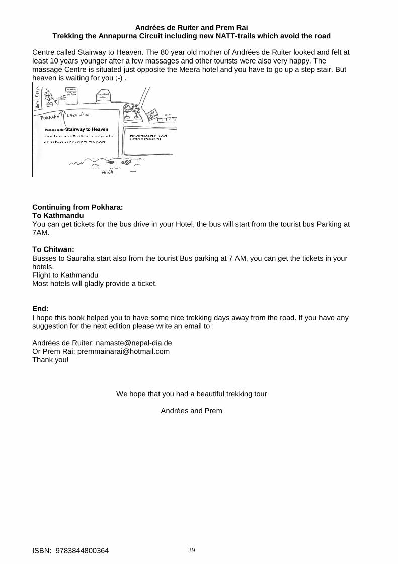
Andrées de Ruiter and Prem Rai Trekking the Annapurna Circuit including new NATT-trails which avoid the road
ISBN: 9783844800364 39
Centre called Stairway to Heaven. The 80 year old mother of Andrées de Ruiter looked and felt at least 10 years younger after a few massages and other tourists were also very happy. The massage Centre is situated just opposite the Meera hotel and you have to go up a step stair. But heaven is waiting for you ;-) .
Continuing from Pokhara: To Kathmandu You can get tickets for the bus drive in your Hotel, the bus will start from the tourist bus Parking at 7AM. To Chitwan: Busses to Sauraha start also from the tourist Bus parking at 7 AM, you can get the tickets in your hotels. Flight to Kathmandu Most hotels will gladly provide a ticket. End: I hope this book helped you to have some nice trekking days away from the road. If you have any suggestion for the next edition please write an email to : Andrées de Ruiter: [email protected] Or Prem Rai: [email protected] Thank you!
We hope that you had a beautiful trekking tour
Andrées and Prem