Embed Size (px)
Citation preview
Typhoons affecting Hong Kong: Case Studies
by
S. Campbell The Hong Kong University of Science and Technology
A report submitted for the APEC 21st Century COE Short Term Fellowship
April 2005
i
Abstract This report, “Typhoons affecting Hong Kong: Case Studies”, accompanies the main document concerning wind-induced damage in Hong Kong, entitled “History of Wind Damage in Hong Kong”. The case studies presented in this report offer the raw data collected from a selected number of storms that have severely damaged Hong Kong or highlighted its vulnerability to typhoons. For a summary of the overall effects of wind and wind-induced damage in Hong Kong, the reader is advised to examine “History of Wind Damage in Hong Kong”. The reader wanting more detail into specific damage occurring during typhoons is recommended to also read this report. This report contains data and qualitative reports from the Hong Kong Observatory, newspapers (published in English) and other sources. While information from the Hong Kong Observatory and newspapers can generally be trusted, other sources, although being valuable, may be anecdotal. Nevertheless, the gathered information is presented as raw data with few comments from the author, thus providing an unbiased account as to what happened during each typhoon.
In addition to “The History of Wind Damage in Hong Kong” and this report, the following is also provided in electronic format for future use solely by the staff and students at Tokyo Polytechnic University: a) A tabulated summary of quantitative typhoon measures and damage categories in the file “COE_WindDamage_HK.xls”. This table contains all relevant typhoon-induced damage data collected between the years 1957 to 2004, inclusive. b) Wind data of hourly mean, hourly direction and gust wind speeds recorded at Waglan Island collected from the Hong Kong Observatory. These data represent the overall winds affecting Hong Kong during a typhoon. It is important to note that correction factors should be applied to adjust these anemometer measurements at different locations on Waglan Island before a proper comparison can be made. These correction factors and how they should be applied are provided in a technical report from the CLP Power Wind/Wave Tunnel Facility at The Hong Kong University of Science and Technology. This report is entitled “A Study of Anemometer Measurements at Waglan Island, Hong Kong” and is supplied in electronic format, labeled as “tr_wwtf002_2003.pdf”
ii
Table of Contents: Page No. Typhoon York (1999)................................................................................................ 1 Typhoon Sam (1999)................................................................................................. 8 Typhoon Dot (1993).................................................................................................. 13 Typhoon Ellen (1983) ............................................................................................... 20 Typhoon Hope (1979) ............................................................................................... 27 Typhoon Rose (1971)................................................................................................ 33 Typhoon Wanda (1962) ............................................................................................ 42 Typhoon Mary (1960) ............................................................................................... 48 The Typhoon of 1937................................................................................................ 51 The Typhoon of 1906................................................................................................ 55 The Typhoon of 1874................................................................................................ 58 The Typhoon of 1847................................................................................................ 60 Appendix A ...............................................................................................................
iii
List of Figures: Page No.
Figure 1: Path of Typhoon York past Hong Kong: September 1999 (after HKO) ... 3
Figure 2: Victoria Harbour during Typhoon York (after van der Woning) .............. 4
Figure 3: Damage to boats caused by Typhoon York (after van der Woning) ......... 4
Figure 4: Aftermath of Typhoon York - Left: Damaged curtain walls of Central
Plaza (striped building) and Immigration Tower; Right: Close-up of
damage to Immigration Tower (after van der Woning)............................. 4
Figure 5: Damaged trees litter the streets after Typhoon York (after van der
Woning) ..................................................................................................... 5
Figure 6: Damaged signboards caused by Typhoon York (after van der Woning) .. 5
Figure 7: Flooding of Shenzhen River caused by Typhoon Dot: viewed from
southeast (after Drainage Services Department)........................................ 18
Figure 8: Shenzhen River in 2002: viewed from southwest (after Drainage
Services Department)................................................................................. 19
Figure 9: Flooding in the New Territories during Typhoon Dot (left), and after
(after Drainage Services Department) ....................................................... 19
Figure 10: Track of Typhoon Ellen past Hong Kong (after HKO)........................... 24
Figure 11: Barograms at different locations within Hong Kong during Typhoon
Ellen (after HKO) ...................................................................................... 24
Figure 12: Anemogram from Waglan Island during Typhoon Ellen (after HKO) ... 24
Figure 13: Anemogram from Tai O during Typhoon Ellen (after HKO) ................. 25
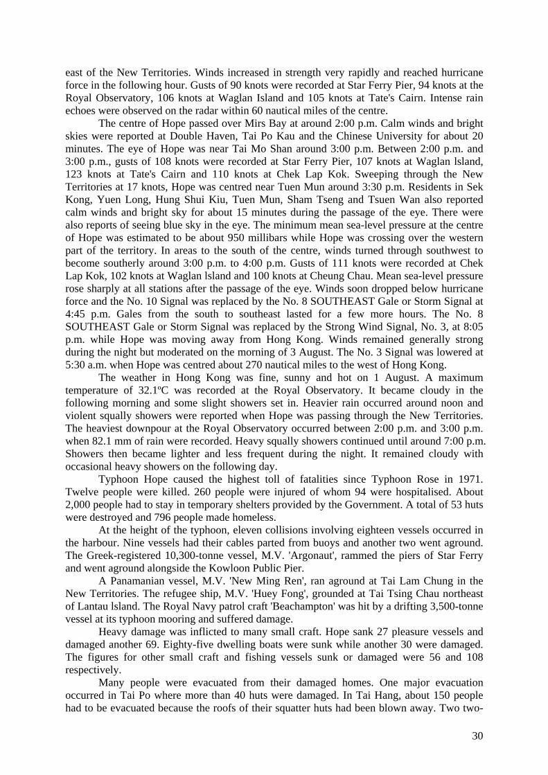
Figure 14: Track of Typhoon Hope past Hong Kong (after HKO)........................... 31
Figure 15: Radar picture of Typhoon Hope taken at 8 a.m. on 2 August, 1979
(after HKO)................................................................................................ 32
Figure 16: Track of Typhoon Rose past Hong Kong (after HKO) ........................... 35
Figure 17: Barographs during the passage of Typhoon Rose (after HKO)............... 36
Figure 18: Anemograph taken at Cape Collinson during Typhoon Rose (after
HKO) ......................................................................................................... 36
Figure 19: Rainfall and pressure readings at the ROHK Headquarters (after
HKO) ......................................................................................................... 37
Figure 20: Landslide caused by Typhoon Rose (after HKO).................................... 38
Figure 21: Nathan Road after Typhoon Rose (after HKO)....................................... 39
Figure 22: Trees uprooted on Nathan Road (after HKO).......................................... 39
iv
Figure 23: Destroyed signboard after Typhoon Rose (after HKO)........................... 39
Figure 24: Destroyed squatter village in Sam Ka Tsuen (after HKO) ...................... 40
Figure 25: Damaged trees in Statue Square (after HKO).......................................... 40
Figure 26: SS Kaohsiung on the rocks (after HKO) ................................................. 40
Figure 27: Damage to berth caused by SS Kota Sentosa (after HKO) ..................... 41
Figure 28: Anemograph recorded at ROHK Headquarters during Typhoon
Wanda (after HKO) ................................................................................... 44
Figure 29: Barograph recorded at ROHK Headquarters during Typhoon Wanda
(after HKO)................................................................................................ 45
Figure 30: Track of Typhoon Wanda through the South China Sea (after HKO) .... 46
Figure 31: Barometer reading during the passage of the 1937 typhoon (after
www.merchantnavyofficers.com).............................................................. 52
Figure 32: Wind speed reading during the 1937 typhoon (after
www.merchantnavyofficers.com).............................................................. 53
Figure 33: Ship aground caused by the 1937 typhoon (after
www.merchantnavyofficers.com).............................................................. 53
Figure 34: ‘An Lee’ as damaged by the 1937 typhoon (after
www.merchantnavyofficers.com).............................................................. 53
Figure 35: ‘Feng Lee’ washed ashore from the 1937 typhoon (after
www.merchantnavyofficers.com).............................................................. 54
Figure 36: Artist rendition of the 1906 typhoon in Hong Kong (after Old Siam
Trading Co.)............................................................................................... 57
Figure 37: Artist rendition of a junk during the 1906 typhoon (after Old Siam
Trading Co.)............................................................................................... 57
1
TYPHOON YORK (1999)
2
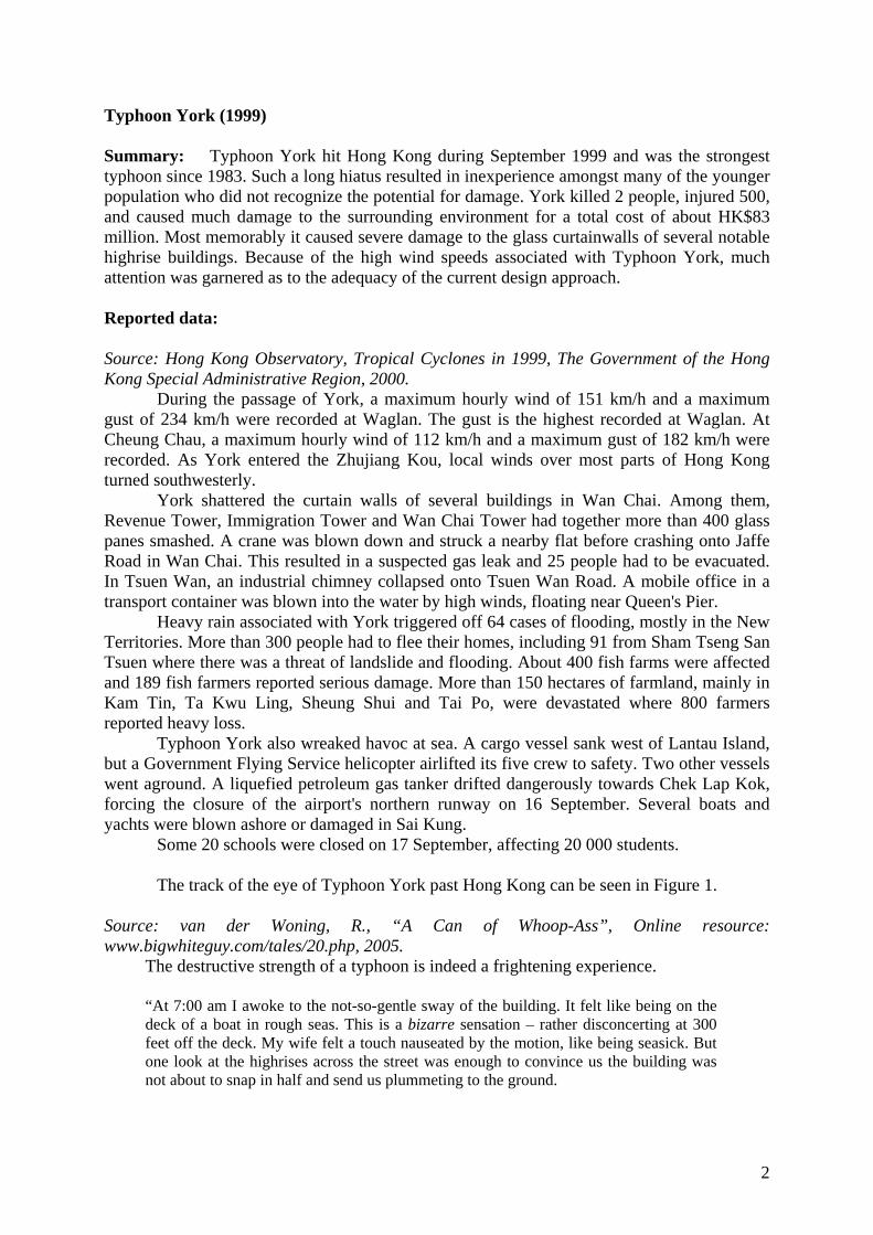
Typhoon York (1999) Summary: Typhoon York hit Hong Kong during September 1999 and was the strongest typhoon since 1983. Such a long hiatus resulted in inexperience amongst many of the younger population who did not recognize the potential for damage. York killed 2 people, injured 500, and caused much damage to the surrounding environment for a total cost of about HK$83 million. Most memorably it caused severe damage to the glass curtainwalls of several notable highrise buildings. Because of the high wind speeds associated with Typhoon York, much attention was garnered as to the adequacy of the current design approach. Reported data: Source: Hong Kong Observatory, Tropical Cyclones in 1999, The Government of the Hong Kong Special Administrative Region, 2000.
During the passage of York, a maximum hourly wind of 151 km/h and a maximum gust of 234 km/h were recorded at Waglan. The gust is the highest recorded at Waglan. At Cheung Chau, a maximum hourly wind of 112 km/h and a maximum gust of 182 km/h were recorded. As York entered the Zhujiang Kou, local winds over most parts of Hong Kong turned southwesterly.
York shattered the curtain walls of several buildings in Wan Chai. Among them, Revenue Tower, Immigration Tower and Wan Chai Tower had together more than 400 glass panes smashed. A crane was blown down and struck a nearby flat before crashing onto Jaffe Road in Wan Chai. This resulted in a suspected gas leak and 25 people had to be evacuated. In Tsuen Wan, an industrial chimney collapsed onto Tsuen Wan Road. A mobile office in a transport container was blown into the water by high winds, floating near Queen's Pier.
Heavy rain associated with York triggered off 64 cases of flooding, mostly in the New Territories. More than 300 people had to flee their homes, including 91 from Sham Tseng San Tsuen where there was a threat of landslide and flooding. About 400 fish farms were affected and 189 fish farmers reported serious damage. More than 150 hectares of farmland, mainly in Kam Tin, Ta Kwu Ling, Sheung Shui and Tai Po, were devastated where 800 farmers reported heavy loss.
Typhoon York also wreaked havoc at sea. A cargo vessel sank west of Lantau Island, but a Government Flying Service helicopter airlifted its five crew to safety. Two other vessels went aground. A liquefied petroleum gas tanker drifted dangerously towards Chek Lap Kok, forcing the closure of the airport's northern runway on 16 September. Several boats and yachts were blown ashore or damaged in Sai Kung.
Some 20 schools were closed on 17 September, affecting 20 000 students.
The track of the eye of Typhoon York past Hong Kong can be seen in Figure 1. Source: van der Woning, R., “A Can of Whoop-Ass”, Online resource: www.bigwhiteguy.com/tales/20.php, 2005.
The destructive strength of a typhoon is indeed a frightening experience.
“At 7:00 am I awoke to the not-so-gentle sway of the building. It felt like being on the deck of a boat in rough seas. This is a bizarre sensation – rather disconcerting at 300 feet off the deck. My wife felt a touch nauseated by the motion, like being seasick. But one look at the highrises across the street was enough to convince us the building was not about to snap in half and send us plummeting to the ground.

3
Added to that load of fun was rainwater leaking through every window and air conditioner in the flat. When driven by hurricane-force winds, water will be forced through any available gap, especially when it’s coming in sideways. I spent most of the day running back and forth with 20 towels to soak up the water before it flooded us out. Looking out the window, I saw white, fluffy thing blowing by. I couldn’t tell what they were, but they looked like flower petals. I realised they were large drops of water being forced upwards by vertical wind shear, which caused the droplets to fragment into petal shapes. I found that neat. All day long, until the early evening, we were forced to stay indoors and listen to the ungodly howl outside the windows. At times it would cycle down low and then come back with fury, and that was freaky. I kept waiting for the windows to explode…. Once outside, we surveyed carnage wrought by York. Trees were either uprooted or snapped. Rubbish and other detritus was blown about everywhere. Garbage bins and signs were overturned. A few local businesses had their frontage signs torn off and destroyed. Dead umbrellas lay about and it still rained…. 429 windows at Revenue Tower and Immigration Tower were blown out at about noon. Most were windows from offices nearly 40 stories up. Some of the windows were from district court…. When public transportation is shut down, taxis and minibus drivers reap the profits. Some charged up to three times the normal fares, saying they were risking their lives by going to work. Most drivers charged between $30 - $50 extra above the regular fare. They feel justified as they’re working at a risk without any insurance coverage. Overcharging is illegal, but passengers are considerate, given the circumstances. If not, they walk, and walking outside during a typhoon isn’t smart.”
Figure 1: Path of Typhoon York past Hong Kong: September 1999 (after HKO)
4
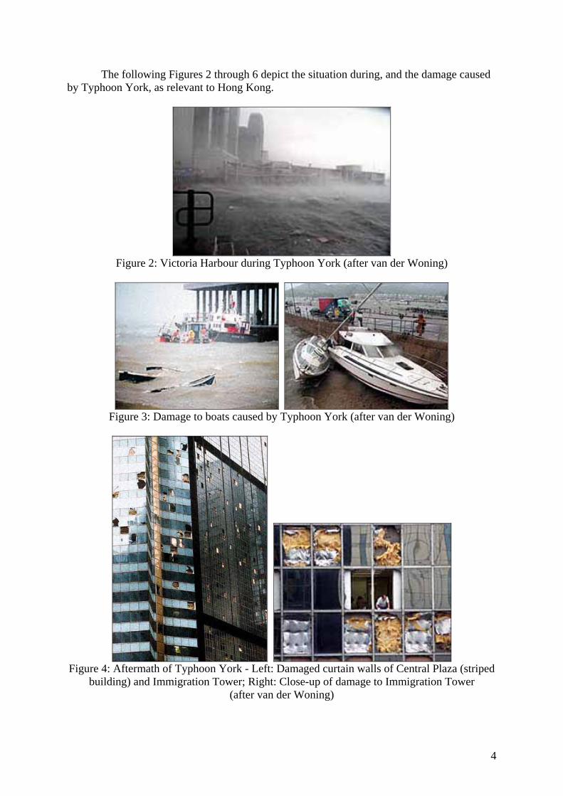
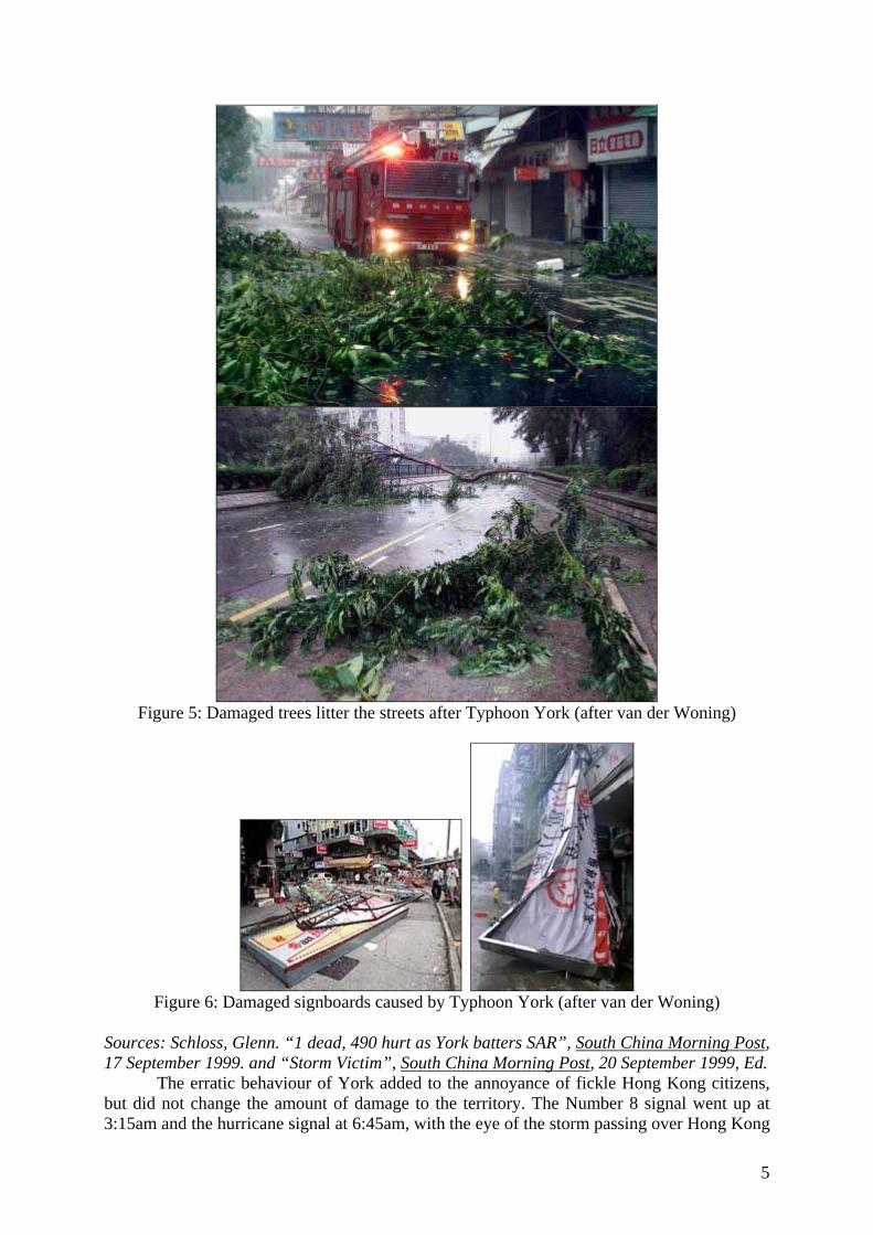
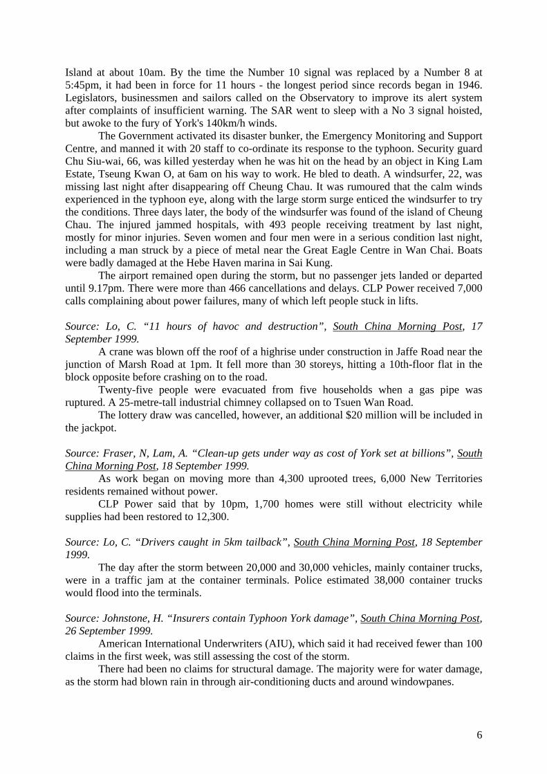
The following Figures 2 through 6 depict the situation during, and the damage caused by Typhoon York, as relevant to Hong Kong.
Figure 2: Victoria Harbour during Typhoon York (after van der Woning)
Figure 3: Damage to boats caused by Typhoon York (after van der Woning)
Figure 4: Aftermath of Typhoon York - Left: Damaged curtain walls of Central Plaza (striped
building) and Immigration Tower; Right: Close-up of damage to Immigration Tower (after van der Woning)
5
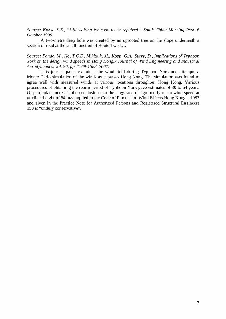
Figure 5: Damaged trees litter the streets after Typhoon York (after van der Woning)
Figure 6: Damaged signboards caused by Typhoon York (after van der Woning)
Sources: Schloss, Glenn. “1 dead, 490 hurt as York batters SAR”, South China Morning Post, 17 September 1999. and “Storm Victim”, South China Morning Post, 20 September 1999, Ed.
The erratic behaviour of York added to the annoyance of fickle Hong Kong citizens, but did not change the amount of damage to the territory. The Number 8 signal went up at 3:15am and the hurricane signal at 6:45am, with the eye of the storm passing over Hong Kong
6
Island at about 10am. By the time the Number 10 signal was replaced by a Number 8 at 5:45pm, it had been in force for 11 hours - the longest period since records began in 1946. Legislators, businessmen and sailors called on the Observatory to improve its alert system after complaints of insufficient warning. The SAR went to sleep with a No 3 signal hoisted, but awoke to the fury of York's 140km/h winds.
The Government activated its disaster bunker, the Emergency Monitoring and Support Centre, and manned it with 20 staff to co-ordinate its response to the typhoon. Security guard Chu Siu-wai, 66, was killed yesterday when he was hit on the head by an object in King Lam Estate, Tseung Kwan O, at 6am on his way to work. He bled to death. A windsurfer, 22, was missing last night after disappearing off Cheung Chau. It was rumoured that the calm winds experienced in the typhoon eye, along with the large storm surge enticed the windsurfer to try the conditions. Three days later, the body of the windsurfer was found of the island of Cheung Chau. The injured jammed hospitals, with 493 people receiving treatment by last night, mostly for minor injuries. Seven women and four men were in a serious condition last night, including a man struck by a piece of metal near the Great Eagle Centre in Wan Chai. Boats were badly damaged at the Hebe Haven marina in Sai Kung.
The airport remained open during the storm, but no passenger jets landed or departed until 9.17pm. There were more than 466 cancellations and delays. CLP Power received 7,000 calls complaining about power failures, many of which left people stuck in lifts. Source: Lo, C. “11 hours of havoc and destruction”, South China Morning Post, 17 September 1999.
A crane was blown off the roof of a highrise under construction in Jaffe Road near the junction of Marsh Road at 1pm. It fell more than 30 storeys, hitting a 10th-floor flat in the block opposite before crashing on to the road.
Twenty-five people were evacuated from five households when a gas pipe was ruptured. A 25-metre-tall industrial chimney collapsed on to Tsuen Wan Road.
The lottery draw was cancelled, however, an additional $20 million will be included in the jackpot. Source: Fraser, N, Lam, A. “Clean-up gets under way as cost of York set at billions”, South China Morning Post, 18 September 1999.
As work began on moving more than 4,300 uprooted trees, 6,000 New Territories residents remained without power.
CLP Power said that by 10pm, 1,700 homes were still without electricity while supplies had been restored to 12,300. Source: Lo, C. “Drivers caught in 5km tailback”, South China Morning Post, 18 September 1999.
The day after the storm between 20,000 and 30,000 vehicles, mainly container trucks, were in a traffic jam at the container terminals. Police estimated 38,000 container trucks would flood into the terminals. Source: Johnstone, H. “Insurers contain Typhoon York damage”, South China Morning Post, 26 September 1999.
American International Underwriters (AIU), which said it had received fewer than 100 claims in the first week, was still assessing the cost of the storm.
There had been no claims for structural damage. The majority were for water damage, as the storm had blown rain in through air-conditioning ducts and around windowpanes.
7
Source: Kwok, K.S., “Still waiting for road to be repaired”, South China Morning Post, 6 October 1999.
A two-metre deep hole was created by an uprooted tree on the slope underneath a section of road at the small junction of Route Twisk… Source: Pande, M., Ho, T.C.E., Mikitiuk, M., Kopp, G.A., Surry, D., Implications of Typhoon York on the design wind speeds in Hong Kong,k Journal of Wind Engineering and Industrial Aerodynamics, vol. 90, pp. 1569-1583, 2002. This journal paper examines the wind field during Typhoon York and attempts a Monte Carlo simulation of the winds as it passes Hong Kong. The simulation was found to agree well with measured winds at various locations throughout Hong Kong. Various procedures of obtaining the return period of Typhoon York gave estimates of 30 to 64 years. Of particular interest is the conclusion that the suggested design hourly mean wind speed at gradient height of 64 m/s implied in the Code of Practice on Wind Effects Hong Kong – 1983 and given in the Practice Note for Authorized Persons and Registered Structural Engineers 150 is “unduly conservative”.
8
TYPHOON SAM (1999)
9
Typhoon Sam (1999) Summary: Typhoon Sam hit Hong Kong in August 1999 and was the wettest typhoon that has ever been recorded in Hong Kong. Many landslides were caused resulting in 4 deaths, 328 injured people and over $130 million in damage. A plane that crashed into the runway at the airport, possibly caused by the complex wind environment during Typhoon Sam, has only recently (2005) finished being investigated. Reported data: Source: Hong Kong Observatory, Tropical Cyclones in 1999, The Government of the Hong Kong Special Administrative Region, 2000. In Hong Kong the Standby Signal No. 1 was hoisted at 4:15 p.m. on 20 August when Sam was about 800km to the east-southeast. The weather on 21 August was fine and very hot with haze at first. The maximum temperature of 35.1ºC recorded at that afternoon was the highest since 1990. Showers began to set in from the late afternoon of 21 August as Hong Kong came under the influence of Sam’s outer rainbands. With Sam moving closer to Hong Kong and winds becoming strong offshore and on high ground, the Strong Wind Signal No. 3 was hoisted at 2:30 a.m. on 22 August. Sam attained typhoon strength before noon and local winds reached gale force at Waglan Island and Cheung Chau. The No. 8 NORTHWEST Gale or Storm Signal was hoisted at 12:30 p.m. Sam was the third tropical cyclone necessitating the hoisting of No. 8 or higher signals in the year. The last time that No. 8 or higher signals had to be hoisted on three separate occasions between January and August was in 1971. After wekening into a severe tropical storm, Sam made landfall over the eastern part of Sai Kung around 6 p.m. on 22 August. Sam was closest to the Hong Kong Observatory Headquarters at around 6:15 p.m. when it was about 25 km to the northeast. Following landfall, Sam traversed the northeastern part of the New Territories at a speed of about 25 km/h and crossed into Shenzhen. During the passage of Sam, the lowest instantaneous mean sea-level pressure recorded was 979.0 hPa at Waglan Island. During the passage of Sam, a maximum hourly wind of 52 km/h and a maximum gust of 115 km/h were recorded at Tap Mun on 22 August. At Waglan, a maximum hourly wind of 96 km/h and a maximum gust of 148 km/h were recorded. As Sam moved into Shenzhen and entered the Zhujiang Kou that night, local winds began to turn southwesterly and the No. 8 SOUTHWEST Gale or Storm Signal was hoisted at 8:10 p.m. With Sam moving gradually away and weakening into a troipical storm, the No. 8 Signal was replaced by the Strong Wind Signal No. 3 at 3:50 a.m. on 23 August. Sam weakened further into an area of low pressure that night and all tropical cyclone warning signals were lowered at 9:00 p.m. The southwesterly winds trailing in the wake of Sam brought heavy rain to Hong Kong. Gusts occasionally reached gale force at that time. The Black Rainstorm Warning Signal was issued at 6:13 a.m. on 23 August and was replaced by the Amber Rainstorm Warning Signal at noon. The Black Rainstorm Warning Signal was raised again on 24 August and in force between 4:35 a.m. and 10:00 a.m. The tropical cyclone rainfall (defined as the total rainfall recorded at the Hong Kong Observatory from the time when a tropical cyclone was centred within 600 km of Hong Kong to 72 hours after the tropical cyclone dissipated or moved outside 600 km of Hong Kong) brought by Sam amounted to 616.5 mm. This exceeded the previous record of 597.0 mm caused by a tropical cyclone in 1926 and made Sam the wettest tropical cyclone ever to affect Hong Kong since records began in 1884. During the passage of Sam, an accident occurred while an aircraft was trying to land at the airport at Chek Lap Kok in the evening on 22 August. Three passengers were killed and more than 200 injured in the incident. Over 360 other flights were delayed or cancelled in the
10
next few days. Ferry services to Cheung Chau, Peng Chau and Mui Wo were suspended in the afternoon on 22 August and some 300 passengers living in these outlying islands were affected. Locally, numerous trees toppled and signboards collapsed in gales and strong winds. Eight causes of traffic accidents resulting from the inclement weather were reported. Seas were very rough, four surfers were reported missing near Tai Mei Tuk but were found later. More than 100 people suffered minor injuries in various storm related accidents. The heavy rain resulted in about 310 cases of flooding and 160 cases of landslides in various parts of Hong Kong. The most severe flooding occurred in the northern New Territories where floodwaters two metres in depth were reported. Some villagers were trapped on rooftops and in trees and had to be rescued. More than 200 residents of Tin Ping Shan, Mai Po, Ta Kwu Ling, Ping Kong, Sham Tseng San Tsuen were forced to flee their homes. In Sham Tseng San Tsuen, one man was buried alive and 28 others were injured in a landslide on 23 August. In Tin Wan in Aberdeen, 30 stores were swamped by mudflow. Many roads on Hong Kong Island were also forced to close due to landslides. On Lantau Island, landslides also caused the closure of Tung Chung Road and South Lantau Road. Bus services on Lantau Island were almost paralyzed on 24 August. In Kowloon, Shek Kip Mei Estate was threatened by possible landslides and over 700 residents had to be evacuated on 25 and 26 August. Source: Johnstone, H. “Insurers contain Typhoon York damage”, South China Morning Post, 26 September 1999
Typhoon Sam created damage of $200 million to $250 million, much of which was commercial. Source:“I’m just a scapegoat, insists a bitter pilot”, South China Morning Post, 6 September 2005, Ed.
The pilot blamed by investigators for a series of deadly blunders leading up to the China Airlines crash at Chek Lap Kok in 1999 has again protested his innocence and insisted the aircraft was at fault.
Mr Lettich and co-pilot Liu Cheng-Hsi were at the controls of the Boeing MD-11 when it lost a wing, flipped over and burst into flames upon landing in Hong Kong on a flight from Bangkok during Typhoon Sam on August 22, 1999.
The inquiry report largely supported an earlier Civil Aviation Department finding that the pilot had caused the crash by failing to control the plane's rate of descent on its final approach.
The report catalogued a series of blunders and mix-ups in the run-up to the landing and said Mr Lettich should have executed a go-around or diverted to another airport because of the severe cross-winds whipping the approach path.
Mr Lettich declined an invitation to appear at the Board of Review hearing in November 2003, but in letters and phone calls has protested his innocence throughout, saying his approach had been problem-free until 1.5 seconds from landing. A sudden change of wind speed pushed the plane hard down onto the runway in a catastrophic sequence of events that Mr Lettich says he was powerless to prevent. Source: “‘It was like a fireball coming down’”, South China Morning Post, 19 November 2002, Ed
Three people were killed and more than 200 injured when the McDonnell Douglas 11 flipped over and burst into flames as it landed at Chek Lap Kok during Typhoon Sam on August 22, 1999.
11
Flight CI642, from Bangkok, had 300 passengers and 15 crew on board when it came in at 6.48pm. Witnesses described the plane being on fire as it came in to land, or after its wing tip had struck the ground.
“I saw the plane like a fireball coming down,” said Toshi Hoshino, a passenger on another flight who was changing planes at the time. “The right wing crashed into the ground and dragged on for a while before a big fireball shot up three storeys high.” More than two hours after impact there were still about 100 people on board, many strapped upside-down in their seats. Source: “Dozens urged to leave homes in slope scare”, South China Morning Post, 31 August 1999, Ed
Dozens of residents may have to abandon Sham Tseng after government engineers found their homes on a flood-torn slope were no longer safe to live in.
At least 28 households were told last night that the upper slope near their homes in Sham Tseng Shan Tsuen was unstable. The warning came after a 53-year-old crippled villager was killed by a flash flood choked with debris last week.
“Recent inspection by helicopters has shown a very large area of landslip on the upper part,” he said. “Under these circumstances, they [officials] feel it won't be safe for people to live there.” He said officials also showed them pictures of boulders on the slope and he agreed they were a threat to the villagers.
On the day the villager died, 28 people were injured as heavy rain swept the SAR, causing flooding and landslides. Most damage occurred in the New Territories, where more than 300mm of rain was recorded.
Source: So, A. “Landslide threat forces 700 to move”, South China Morning Post, 27 August 1999
Seven hundred people are to be re-housed because a landslide threatens their homes in Shek Kip Mei Estate.
The cause of the slide was initially believed to be a sudden build-up of water - due to Typhoon Sam's torrential rain - rather than a lack of maintenance. There was no way of monitoring water build-up in the slope, built about 40 years ago. Source: Lam, A. “Typhoon doubles vegetable prices”, South China Morning Post, 25 August 1999.
Vegetable prices had doubled since Typhoon Sam destroyed crops, sellers said yesterday. Prices displayed at market stalls showed Chinese white cabbage was up to $12 a catty from $5 on Saturday and the usual bitter squash price of $4 was up to $8.
The shortage is compounded because crops from remote fields on the mainland could not be transported to markets due to traffic chaos caused by the effects of the storm. Source: Parsons, C. “Storm troopers lash out over Typhoon Sam”, South China Morning Post, 24 August 1999.
Hardline weather enthusiasts are whipping themselves into a frenzy of indignation over Typhoon Sammy. The target of their wrath is the Hong Kong Observatory (HKO). The rain spotters seem to believe the public should have been given more - and better - information about the typhoon's progress.
“We are very angry that HKO is trying to kill people by hoisting the number eight [signal] so late, e.g., the Peng Chau ferry incident and the yacht incident” one rain spotter said.
Another spotter, who observed the storm from Chek Lap Kok, told the Weather Underground Forum: “The HKO deserves to be investigated, and take the blame for its complacent attitude towards this storm. Why didn't they warn the public of the direct hit in the
12
Northern New Territories? I did venture out into the wind and rain outside the terminal building, and I must say that I was completely drenched in 30 seconds. The gales pounded me so badly that I actually swayed in the wind. The torrential rain scratched my face so fiercely that I couldn't bear [it] for more than a few minutes before pain drove me back into the terminal building.”
Meanwhile, across the SAR in Tuen Mun, another rain man was mad with grief. How could the observatory have betrayed him so? “Now the wind is going crazy,” he told the forum. I don't know why the HKO would do such a job, educate the public that the number eight will only be hoisted a few more hours, implying that the wind will decrease and go out. HKO, HKO you let my heart die.” Source: Chan, F. “Confusion reigns over working in storms”, South China Morning Post, 24 August 1999.
Thousands of people did not know whether to report for work yesterday as the remnants of Typhoon Sam battered the territory.
The Labour Department's 'Code of Practice in Times of Typhoons and Rainstorms' states: 'Employees should not be required to return to work just as a matter of course.' In deciding whether workers should return, employers need to consider the risks of travel and their liabilities under the Employees' Compensation Ordinance. The code says that when Signal No 8 or the black rainstorm warning is lowered not less than three hours before the normal end of working hours, employees should return to work as soon as possible. Source: “Injuries and ferry sit-in while Sam rampages”, South China Morning Post, 24 August 1999, Ed.
Typhoon Sam had already led to the diversion and delay of flights before the crash forced the closure of the airport.
The typhoon was downgraded to a severe tropical storm at 5pm, but heavy, squally showers and gale-force winds will continue today.
The No 8 signal was hoisted at 12.30pm and was still in force at 1.30am today. Winds of up to 155km/h were reported throughout yesterday, with the west taking the brunt of the storm.
More than 100 passengers on board a Cheung Chau-bound vessel refused to get off at the Outlying Islands pier in Central when they were told the service, operated by the Hongkong & Yaumati Ferry Company, had been cancelled.
At 1am today, police went on board to ask them leave, but were ignored by the passengers. “I think they will stay there overnight. We have done what we can to persuade the passengers to leave, but they are determined,” the police spokesman said. Stranded Peng Chau and Cheung Chau residents had accused the operator of advancing the time of last services without notice.
Tsui Pik-ying, 40, a cosmetics saleswoman from Peng Chau, said: “I called and was told the last ferry would leave at 12.45pm. I arrived one hour earlier, bought the ticket, then was told the last ferry service had been cancelled.” The company said it could not risk passengers' safety.
A family escorting a relative's body to Cheung Chau for a funeral had to send the coffin back to the funeral parlour.
In other incidents, 100 people were reported injured by early evening, none seriously. Thirty-three temporary shelters were opened throughout the SAR, providing refuge for
525 people. By midnight, 51 reports of flooding had been received, all of a minor nature. A falling tree hit three women and a man in Yuen Yuen Hok Yuen, Tsuen Wan, with
one woman staying in hospital overnight.

13
14
TYPHOON DOT (1993)
15
Typhoon Dot (1993) Summary: Typhoon Dot affected Hong Kong in September of 1993. Damage resulted mostly from flooding rather than winds associated with Typhoon Dot. Especially hard hit was the northern parts of the New Territories with the Shenzhen River along the Mainland China border being overwhelmed. The consequence of the Shenzhen River being flooded was highly political with a solution that straightened some sections, taking away land from many property owners on both sides of the border. The final construction works are scheduled to finish in 2006, 13 years after Typhoon Dot. Reported data: Source: Royal Observatory Hong Kong, Tropical Cyclones in 1993, Government Publications Centre, 1995.
An area of disturbance over the South China Sea developed into a tropical depression named Dot on 23 September. Over the waters east of Hainan Island, Dot intensified into a tropical storm on the afternoon of 24 September while moving north-northeastwards at a speed of 8 km/h towards the coast of western Guangdong. It deepened into a severe tropical storm on the early morning of 25 September and began to track northwards. An eye could be identified at the center of Dot as it attained typhoon strength about 300 km southwest of Hong Kong that afternoon. Dot reached peak intensity on the early morning of 26 September. The minimum sea-level pressure and maximum sustained winds near its center were estimated to be 965 hPa and 140 km/h respectively. Dot then accelerated to about 12 km/h and made landfall over the coast of western Guangdong about 180 km west-southwest of Hong Kong in the afternoon. Dot weakened rapidly into a tropical storm shortly afterwards. It became a tropical depression early net morning about 190 km west of Hong Kong and eventually dissipated over land. In Hong Kong, as the strong northeast monsoon gave way to the strong winds brought on by Dot on 25 September, the Strong Monsoon Signal was replaced by the Strong Wind Signal No. 3 at 4:15 pm that day when Dot was about 290 km to the southwest. As Dot came closer to Hong Kong on 26 September, winds strengthened further. The No. 8 SOUTHEAST Gale or Storm Signal was hoisted at 9:15 am that morning when Dot was about 210 km to the west-southwest. As Dot made landfall in the afternoon and local winds began to subside, the No. 8 SOUTHEAST Gale or Storm Signal was replaced by the Strong Wind Signal No. 3 at 4:00 pm. This was also the time when the lowest sea-level pressure of 1,005.7 hPa was recorded at the Royal Observatory. All signals were lowered at 6:00 pm in the evening. Dot was closest to Hong Kong on the early morning of 27 September when it was about 150 km to the west-northwest. Torrential rain affected the territory during the night of 26 September, but the weather improved the following day. During the passage of Dot, nine people were injured by collapsed scaffoldings and toppled trees. A traffic accident occurred in Aberdeen, injuring six more people. The heavy downpour associated with Dot triggered 63 landslips, causing chaos and interruption to traffic in Ap Lei Chau, Repulse Bay, Central and Tai Po. In Tsuen Wan, a mudslide damaged a gas pipe and more than 70 families had to be evacuated. The low-lying areas in the northern New Territories suffered from some of the worst flooding seen in recent decades. More than 40 villages were inundated and over 200 villagers stranded. A total of 33 people were injured. More than 450 hectares of farmland, about one third of the total in Hong Kong were flooded. Nearly 2,000 households of crop farmers and 50 households of fish farmers were affected. Damage to crops, livestock and fisheries amounted to about HK$ 80 million. In addition, electricity supply to 1,400 households was cut off.
16
At sea, a fisherman was reported missing from a boat that sank in rough seas near Hong Kong. Ferry services to outlying islands, Macau and China were suspended. At the airport, several flights were cancelled, diverted or delayed. Dot brought plenty of rain to the territory and 14 out of 17 reservoirs in Hong Kong were full in the wake of Dot. Source: Gilbert, A. “Praise floods in for brave policeman”, South China Morning Post, 9 August 1994.
Constable Tang Tai-wai should have received a commendation yesterday for the part he played in a dramatic series of flood rescues last year, but he has been stranded in Guangdong by this season's heavy rains. However, five other officers were commended for their bravery, courage and devotion to duty in rescuing 36 people from the floods caused by Typhoon Dot. Source: Tik, C-Y. “Government must take blame for floods crisis”, South China Morning Post, 3 October 1994.
It is sad this recognition has only come at the price of the destruction of $80 million worth of crops, as well as the fish in more than 2,000 farms, while cross-border trade and travel was also temporarily brought to a standstill.
Before the disaster, the Government did not take the threat of flooding seriously, even though I, my colleagues in Meeting Point, as well as Northern District Board members have called for such improvements for many years. I remember Planning, Environment and Lands Branch officials telling me in 1988 that the project to improve defenses against flooding along the Shenzhen River was not cost-effective despite a severe flooding of the New Territories in 1988. Source: Ng, K.-C. “Concern grows for river scheme”, South China Morning Post, 30 September 1993.
Meanwhile, 200 farmers whose crops were destroyed during the typhoon flooding can expect to collect a maximum $3,200 in emergency relief from the Agricultural and Fisheries Department today.
Up to yesterday 1,494 farmers had applied to the department for the grants. Source: Lee, S. “Typhoon Dot kills two in China”, South China Morning Post, 29 September 1993.
Typhoon Dot killed two people in southern Guangdong and destroyed or damaged 31,000 houses, causing losses of 1.36 billion yuan (HK$1.82 billion), it was revealed yesterday.
A report by the semi-official Hong Kong China News Agency said 1.38 million people were hit by the storm with 148,000 people flooded out in 133 towns. The storm damaged 177,500 tonnes of farm products, sank 10 ships and left another missing.
Two people were killed and one was missing in Shenzhen. But the city's paralysed traffic system was back to normal with submerged roads reopened after the water retreated. Source: Barbeliuk, A. “Mudslide campaign fell on deaf ears”, South China Morning Post, 28 September 1993.
About 30 of yesterday's slides affected roads and footpaths, 15 occurred next to buildings and 18 forced the evacuation of squatters.
The worst affected area was Mid-Levels, which suffered about 640 millimetres of rain. A residential block, Allway Gardens in Tsuen Wan, was evacuated after a mudslide at
6 am yesterday. It damaged a gas pipe, and emergency officers from the Geotechnical Engineer Office, firemen and TownGas crews sectioned off the area.
17
During Severe Tropical Storm Becky, which swept Hong Kong 11 days ago, 11 mudslides were reported. Dr Malone said ''there will never be another Baguio'', but mudslides would continue unless private residents took responsibility for their homes. Mr. Malone said his office had stepped up its efforts to investigate and maintain dangerous slopes since the Pokfulam landslip which killed two people in Baguio Villas in May last year. He said that the Government had so far investigated 6,000 of the 10,000 slopes in the territory and about one in five of those had been upgraded. Source: “Concert refund”, South China Morning Post, 28 September 1993, Ed.
Hong Kong's hard rock fans will receive a full refund on their tickets for Saturday's Bon Jovi concert at Ocean Park which was washed out by Typhoon Dot. Negotiations are continuing to find another date for the band to perform. Source: Loh, M, Adams, B. “Airlines asked to give better warnings”, South China Morning Post, 27 September 1993.
The Consumer Council has urged airlines to give better warnings to passengers about flight delays caused by typhoons. Thousands of people were stuck as six flights were cancelled, one incoming plane was diverted and 30 were delayed up to 5:30 pm. Source: “Firemen battle flooding to save terrified villagers”, South China Morning Post, 27 September 1993, Ed.
Life rafts were used to rescue at least 30 villagers in the northern New Territories last night after torrential rain accompanying Typhoon Dot led to widespread flooding.
A police spokesman said they had received dozens of calls from villagers in the Sheung Shui, Shataukok, Fanling and border areas where, in the worst cases, flood water rose more than three metres.
In all, there were 25 reports of flooding throughout the territory yesterday as the worst of Dot saw the No 8 signal raised and Hong Kong virtually brought to a halt.
Nine people were hurt, mostly by branches falling from trees. Four men and five women were admitted to hospital with minor hand and leg injuries.
At Sha Tin and Central, the worst hit areas, up to 300 mm were recorded and at one point it was thought the Shing Mun River might also burst its banks. So far this month, 570 mm of rain have fallen - almost double the September average - and weathermen forecast more for today.
At least 13 landslides were reported, seven on Hong Kong Island and three each in Kowloon and the New Territories. A section of Repulse Bay Road between No 37 and No 43 was closed after a mudslide. Ap Lei Chau Bridge was also affected by a minor mudslide in the afternoon. At the height of the storm, ferry services to Discovery Bay and other outlying islands, China and Macau were suspended. Source: Braude, J. “Crack down on taxis”, South China Morning Post, 27 September 1993, Ed.
The passage of Typhoon Dot brought out the taxi cheats, those maverick taxi drivers who have no qualms about overcharging passengers. The practice has become so commonplace that, as we report elsewhere, even police officers are turning a blind eye. Despite the continuing bad publicity, the authorities appear to be doing nothing to stamp out the practice.
Transport officials say they are helpless to do anything as long as the police, who have given the matter a low priority, are responsible for traffic enforcement. Knowing this, the taxi cheats feel they can put their out-of-service signs up, charge what they want and get away with it.
18
Source: Adams, B., Lee, S. “Action urged on taxi surcharges”, South China Morning Post, 27 September 1993.
The Government was last night urged to act after taxi drivers again used a typhoon as an excuse to exploit passengers. Fares shot up as drivers demanded surcharges for working during Typhoon Dot, and there was confusion over what drivers can and cannot do when the No 8 signal is hoisted.
Source: Parke, R., Careem, N. “Dot washes out Sha Tin’s big night”, South China Morning Post, 26 September 1993.
Typhoon Dot played havoc with the territory's sporting activities yesterday, causing the abandonment of the weekend's biggest event - last night's eight-event horse-racing meeting at Sha Tin.
Today's First Division soccer match between Voicelink and Kitchee is also likely to suffer the same fate.
Source: “One lost as Dot closes in”, South China Morning Post, 26 September 1993, Ed.
A fisherman was missing, presumed dead early this morning as Typhoon Dot moved closer to Hong Kong, the third storm in two weeks to bring stormy weather to the territory.
The Government Flying Services and Marine Police were on standby this morning for emergency search and rescue operations. Source: Chan, D., Won, L. “One missing as Dot closes on territory”, South China Morning Post, 26 September 1993.
In a dramatic rescue yesterday morning, five crewmen from a Chinese fishing vessel were plucked from the sea and transferred to Marine Police launches after spending more than 24 hours fighting for their lives. Another two fishermen from the vessel were picked up by a passing boat.
Mok Hing-yim, a scientific officer at the Royal Observatory, said the No 3 signal was hoisted at 4.15 pm without first raising the No 1 standby signal because of the two types of wind systems affecting Hong Kong and also because Dot had intensified so quickly. ''We'll be closely monitoring the movement of Dot, and the Royal Observatory will decide if typhoon signal No 8 will be hoisted early tomorrow morning,'' he said.
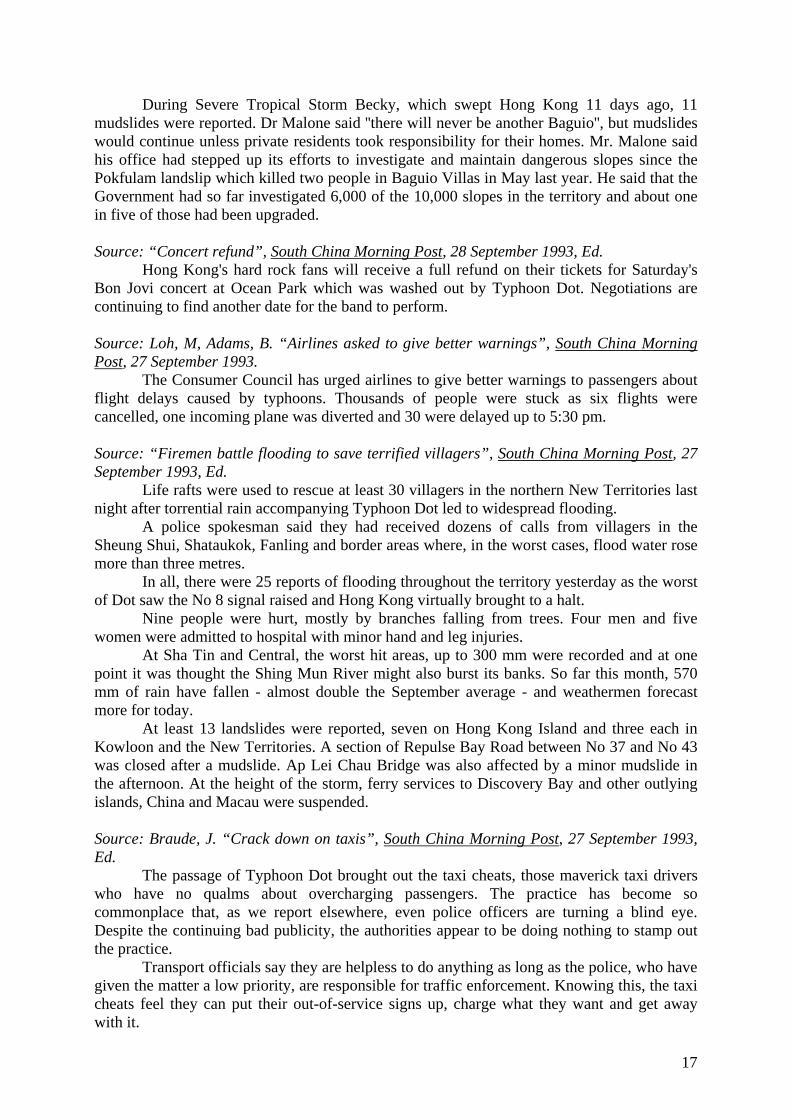
A section of Sheung Foo street in Ho Man Tin also collapsed in the downpour. Figure 7 and 8 show the effects of flooding along the Shezhen River and after prevention measures have been put in place, respectively.
Figure 7: Flooding of Shenzhen River caused by Typhoon Dot: viewed from southeast
(after Drainage Services Department)
19
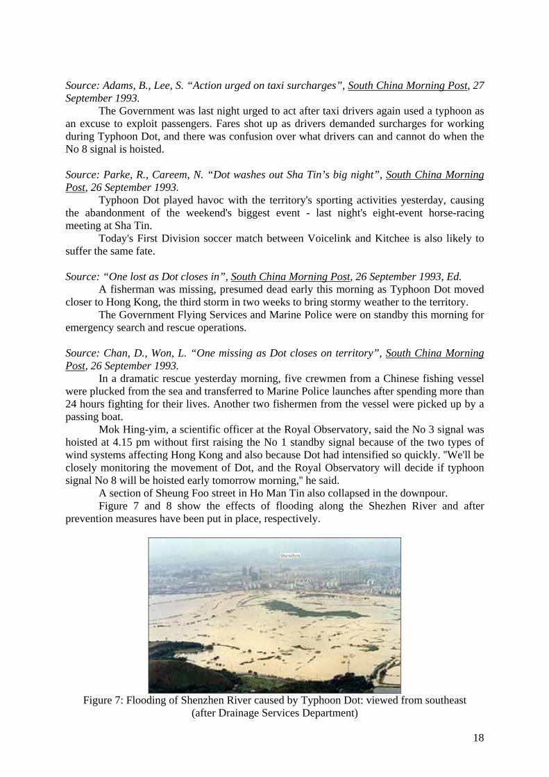
Figure 8: Shenzhen River in 2002: viewed from southwest
(after Drainage Services Department)
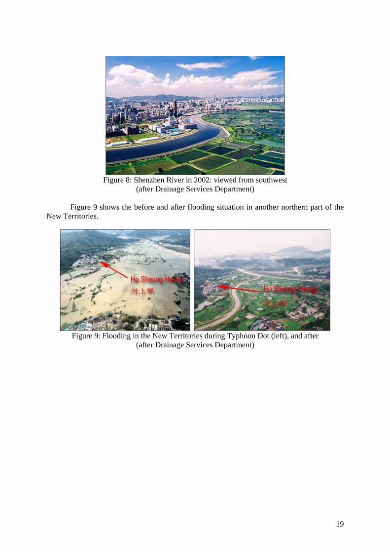
Figure 9 shows the before and after flooding situation in another northern part of the New Territories.
Figure 9: Flooding in the New Territories during Typhoon Dot (left), and after
(after Drainage Services Department)

20
TYPHOON ELLEN (1983)
21
Typhoon Ellen (1983) Summary: Typhoon Ellen hit Hong Kong in August and September 1983. Havoc was caused at sea with many ships being damaged or destroyed along with moorings and docks. Ten people were killed with 12 missing and 333 injured. Estimates at the total cost of damage were in the range of HK$ 300 million. Reported data: Source: Hong Kong Observatory, “Typhoon Ellen (8309) 29 August – 9 September 1983”, Online Resource: http://www.hko.gov.hk/informtc/no10/ellen/ellen.htm, The Government of the Hong Kong Special Administrative Region, 2005.
Typhoon Ellen originated as a tropical depression near the Marshall Islands over the Pacific on 29 August. It moved westwards and intensified into a typhoon on 4 September about 520 nautical miles east of Manila. Ellen continued to intensify and its eye became discernible on satellite pictures as it travelled northwestwards at 12 knots towards the Balintang Channel. Ellen attained its maximum intensity during the morning on 6 September. At 7.43 a.m. a reconnaissance aircraft reported a minimum sea-level pressure of 928 millibars and a maximum sustained surface wind of about 110 knots near the centre about 270 nautical miles northeast of Manila. 21 Taiwanese fishermen were drowned when their boats capsized in waters off the Philippines. Ellen weakened as it crossed the Balintang Channel at 10 knots in a west-northwest direction. It passed about 20 nautical miles off the northern coast of Luzon and entered the South China Sea in the morning of 7 September. At 7.49 a.m. a reconnaissance aircraft reported a minimum pressure of 966 millibars and a maximum sustained surface wind of 70 knots. It moved west-northwestwards towards Dongsha at 8 knots and both satellite pictures and aircraft reconnaissance reports showed that it reintensified slightly. At 7.15 p.m. on 7 September, a reconnaissance aircraft reported a minimum sea-level pressure of 959 millibars near the centre. Ellen passed about 15 nautical miles southwest of Dongsha at about 9.00 a.m. on 8 September. Two fishing junks from Hong Kong capsized and three others went aground while they were taking shelter there. 46 people were saved but 5 were missing. 10 fishing junks from Taiwan also took shelter near Dongsha Qundao and were either sunk or driven aground. 100 fishermen were saved but 41 were missing. In the afternoon of 8 September, an eye was again observed on the satellite picture. Ellen continued west-northwestwards at 8 knots approaching the South China coast. At 11.00 p.m. on 8 September, the M.V. 'Frankfurt Express' reported a surface wind of 52 knots about 80 nautical miles northeast of the centre. A Taiwanese junk capsized about 120 nautical miles south of Hong Kong during the night. One fisherman was saved but 6 were missing. Satellite pictures taken during the night of 8 September are shown in.
Ellen passed to the south of Hong Kong moving in a northwest direction. It came closest to Hong Kong around 7.00 a.m. on 9 September with its centre about 7 nautical miles off Fan Lau, the southwestern tip of Lantau lsland. The minimum pressure and maximum sustained surface wind near the centre were estimated to be 960 millibars and 85 knots respectively. The eye of Ellen was over Macau from about 8.20 a.m. to 8.45 a.m. when winds there dropped to about 15 knots for 25 minutes. Maximum surface winds of 52 knots and a minimum sea-level pressure of 970 millibars were recorded at Macau. 16 people were killed and about 50 sampans and junks capsized. Ellen then moved north-northwest into Guangdong causing tremendous damage to eight counties in the province. A total of 16 people were killed, 92 injured and 16 were missing in Zhuhai, Shenzhen and Panyu. In Zhuhai, 180 houses were completely destroyed and almost 1 000 hectares of crops damaged. One person was killed. 6 boats were wrecked near the town and thousands of telephone and telegraph poles were brought down. 5 people were killed in Shenzhen and 3 in Panyu. 7 Chinese navy sailors were
22
killed during rescue operations in the Zhu Jiang estuary. At 4.00 p.m. on 9 September, the centre of Ellen passed about 10 nautical miles west of Guangzhou, where a sea-level pressure of 993.5 millibars was recorded. At 4.10 p.m. the water level of Zhu Jiang near Guangzhou rose to 2.42 metres, the highest since 1942. In Dongguan County, 100 hectares of crops were inundated and more than 32 000 people were marooned as a result of extensive flooding. As Ellen moved further inland it weakened into a tropical storm and dissipated rapidly during the night.
In Hong Kong the Stand By Signal, No. 1, was hoisted at 5.00 a.m. on 7 September when Ellen was about 420 nautical miles east-southeast of Hong Kong. Winds in Hong Kong were light and mainly from the east. Winds became northerly the next morning. The Strong Wind Signal, No. 3, was hoisted at 7.45 a.m. and the wind became fresh to strong during the afternoon. The Northeasterly Gale or Storm Signal, No. 8 NE, was hoisted at 4.45 p.m. By 9.00 p.m., winds over Hong Kong were generally strong from the north to northeast and gale was reported at Waglan lsland. Between midnight and 1.00 a.m., the hourly mean wind speed at Waglan lsland increased rapidly from 59 knots to 76 knots. The Increasing Gale or Storm Signal, No. 9, was hoisted at 1.00 a.m. on 9 September. The Hurricane Signal, No. 10, was hoisted at 2.00 a.m. As Ellen passed to the south of Hong Kong moving in a northwest direction, Waglan lsland was the first to experience hurricane force winds. Between 4.00 and 5.00 a.m. Waglan lsland reported its maximum hourly mean wind, 86 knots from the southeast. Between 6.00 a.m. and 7.00 a.m. Cheung Chau reported its maximum hourly mean wind of 90 knots and the maximum gust of 128 knots from the south-southeast. Hurricane force winds continued to affect Hong Kong for the next few hours. Winds dropped below hurricane force at Cheung Chau around 10.00 a.m. and the No. 10 Signal was replaced by the Southeasterly Gale or Storm Signal, No. 8 SE. Winds veered from southeast to southwest as Ellen moved further away on a northwesterly track. At 2.00 p.m., the No. 8 SE Signal was replaced by the Southwesterly Gale or Storm Signal, No. 8 SW Signal. The No. 8 SW Signal was replaced by the No. 3 Signal at 5.37 p.m. when gales subsided. Winds remained gusty fresh to strong for most of the night and all signals were lowered at 9.20 p.m. on 9 September.
The weather was fine and hot in Hong Kong on 7 September. It became cloudy with scattered showers and squally thunderstorms during the morning on 8 September when the outer rainbands of Ellen began to affect the territory. The rain became more frequent as Ellen approached Hong Kong during the night. The radar showed a circular eye and intense echoes in the southern quadrant of the typhoon. The rain was heaviest just after dawn on 9 September. A tornado was reported at Shek Wu Wai San Tsuen, San Tin, around 1.15 p.m. The effects of the tornado were felt at ground level for a few seconds. Several wooden huts were destroyed but no one was injured. This was the second tornado known to cause some damage in Hong Kong. It was also the first tornado reported during the passage of a typhoon in Hong Kong. It remained overcast with rain for most of 9 September. The weather improved the next day. There were scattered showers but also sunny periods.
On this occasion, it was fortunate that the maximum storm surges occurred at times when the normal tide levels were relatively low. The highest tide levels were therefore not as high as they would have been had the maximum surges occurred at the times of normal high tides.
Typhoon Ellen brought about a death toll of 10 with 12 people missing and 333 people injured. (The incidents involving the 'Osprey', a 56-metre pleasure yacht, and fishing boats near Dongsha are included). 274 huts collapsed and about 1 600 people were made homeless. At the height of the typhoon, 44 ocean-going vessels were in serious difficulties. 26 ships totalling 250 000 tonnes ran aground, mainly in north Lantau and the Kau Yi Chau area. A couple of the ships listed badly and 23 others were involved in a total of 15 collisions. The stern of the 9 500-tonne Singapore freighter, 'Golden Fortune', one of 5 ships which went aground at Kau Yi Chau, was partly awash. The 9 300-tonne Taiwanese vessel 'Hua Lien'
23
smashed the Mobil Oil Co.'s berth on Tsing Yi Island. About 100 metres of the jetty, pipeline, supporting piles and mooring dolphins were completely destroyed. The 6000-tonne Cypriot cargo ship, 'City of Lobito', came close to slamming into a modern beachside apartment complex on Tung Wan, Cheung Chau. The 5 300-tonne 'Pacific Coral' was stranded on a shallow bank off northern Lantau and listed heavily. The 1000-tonne container ship, 'Zim Manila II', crunched high on the rocks at Hei Ling Chau. Ellen's toll on shipping in terms of numbers exceeded those of Typhoon Rose in 1971 and Typhoon Wanda in 1962. Rose claimed 34 shipping casualties and Wanda 36. But unlike the other two, Ellen caused no reported casualties among seamen. However, 2 fishermen were drowned and 1 was missing after a fishing boat went aground at Tai Long Wan on Lantau. 5 others were missing when their junks capsized at Dongsha Dao. The pleasure vessel 'Osprey' sank about 12 nautical miles south of Hong Kong. Only 1 crew member was saved near Wanshan Qundao about 60 nautical miles south of Hong Kong. 2 bodies were found and 6 other crew members were missing. 135 small craft were sunk and 225 others were damaged. These included pleasure craft, fishing vessels, dwelling boats, etc. Of these, about 200 pleasure craft were sunk or damaged, mostly in Pak Sha Wan, Sai Kung, Aberdeen and Deep Water Bay. Initial reports indicated that 1 500 hectares of crops and about 80 per cent of the territory's vegetables under cultivation were damaged by floods and winds. About 10 000 farmers were affected. About 100 000 chickens and 2 300 pigs were drowned in the flooding. The most seriously affected areas were Yuen Long and Kam Tin. 120 hectares of fish ponds were flooded, mostly in Tin Shui Wai, Kam Tin and Ngau Tam Mei. There was also tremendous destruction to marine culture craft in Sok Kwu Wan, Silver Mine Bay, Sha Tau Kok and Tap Mun. The total loss of crops and livestock amounted to HK$50 million.
Some 80 000 households in Kowloon and the New Territories suffered power failure when Ellen was closest to Hong Kong. Power went out on Lantau lsland around 3.00 a.m. There were no major disruptions on Hong Kong Island. Some places in Kwun Tong, Sha Tin, Fanling, Sai Kung, Yuen Long and Lantau lsland had no electricity supply for more than 4 days. Water supply was interrupted at several estates in Ha Kwai Chung because of the power failure at Lai Chi Kok Pumping Station. Water supply at Mei Foo Sun Chuen was also interrupted due to the failure of the estate's internal service pumps which were flooded.
There was a total of 150 reports of flooding and 250 reports of roads being blocked by fallen trees, collapsed scaffolding, sign-boards and other debris. Mei Foo Sun Chuen was flooded by sea water up to a maximum depth of about 2 metres in places. 12 000 trees in the urban area and another 2 000 in the New Territories were uprooted or broken. 1 092 traffic lights were damaged and 542 bollards smashed. Public transport came to a complete halt at the height of the typhoon. At the airport, there were 7 flight cancellations, 13 delayed departures and 9 diversions.
From a survey of loss adjusters and underwriters, insurance claims totalled about HK$300 million, including HK$180 million for wind and water damage to domestic, commercial and industrial premises, HK$90 million for damage on construction sites, HK$20 million for salvage and repairs to grounded ships and HK$10 million for pleasure boats destroyed or damaged.
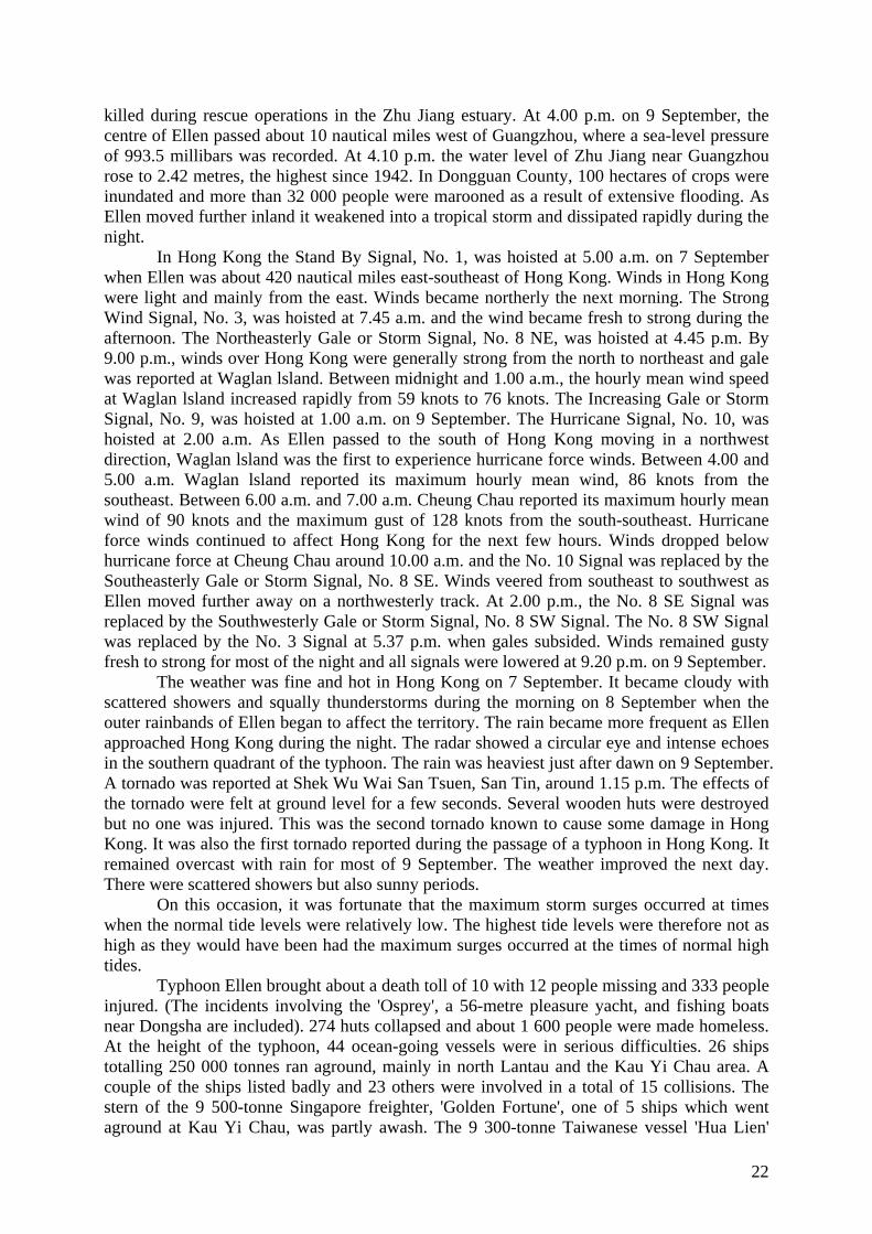
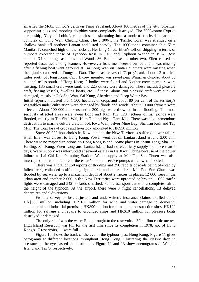
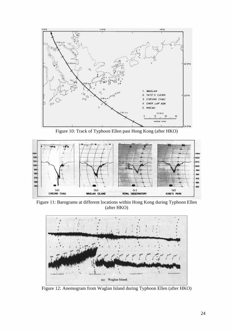
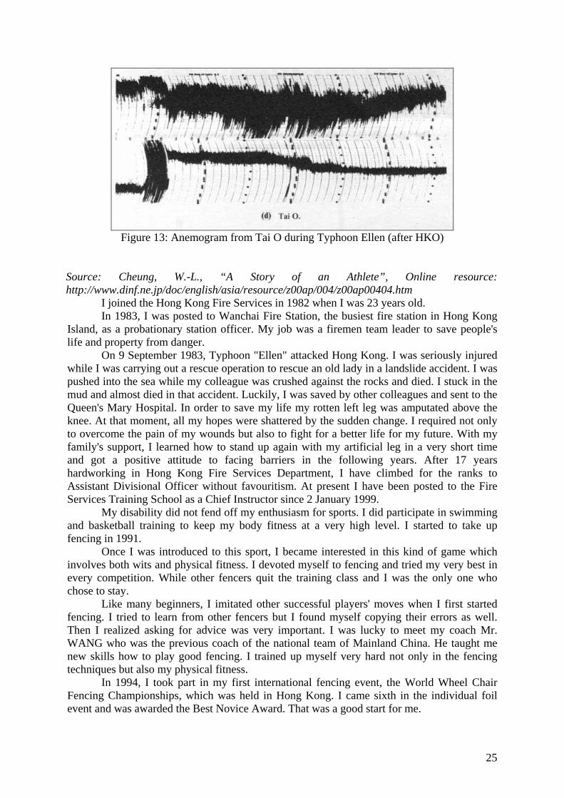
The only relief was the water Ellen brought to the reservoirs - 32 million cubic metres. High lsland Reservoir was full for the first time since its completion in 1978, and of Hong Kong's 17 reservoirs, 11 were full. Figure 10 shows the track of the eye of the typhoon past Hong Kong. Figure 11 gives barograms at different locations throughout Hong Kong, illustrating the classic drop in pressure as the eye passed their locations. Figure 12 and 13 show anemograms at Waglan Island and Tai O, respectively.
24
Figure 10: Track of Typhoon Ellen past Hong Kong (after HKO)
Figure 11: Barograms at different locations within Hong Kong during Typhoon Ellen
(after HKO)
Figure 12: Anemogram from Waglan Island during Typhoon Ellen (after HKO)
25
Figure 13: Anemogram from Tai O during Typhoon Ellen (after HKO)
Source: Cheung, W.-L., “A Story of an Athlete”, Online resource: http://www.dinf.ne.jp/doc/english/asia/resource/z00ap/004/z00ap00404.htm
I joined the Hong Kong Fire Services in 1982 when I was 23 years old. In 1983, I was posted to Wanchai Fire Station, the busiest fire station in Hong Kong
Island, as a probationary station officer. My job was a firemen team leader to save people's life and property from danger.
On 9 September 1983, Typhoon "Ellen" attacked Hong Kong. I was seriously injured while I was carrying out a rescue operation to rescue an old lady in a landslide accident. I was pushed into the sea while my colleague was crushed against the rocks and died. I stuck in the mud and almost died in that accident. Luckily, I was saved by other colleagues and sent to the Queen's Mary Hospital. In order to save my life my rotten left leg was amputated above the knee. At that moment, all my hopes were shattered by the sudden change. I required not only to overcome the pain of my wounds but also to fight for a better life for my future. With my family's support, I learned how to stand up again with my artificial leg in a very short time and got a positive attitude to facing barriers in the following years. After 17 years hardworking in Hong Kong Fire Services Department, I have climbed for the ranks to Assistant Divisional Officer without favouritism. At present I have been posted to the Fire Services Training School as a Chief Instructor since 2 January 1999.
My disability did not fend off my enthusiasm for sports. I did participate in swimming and basketball training to keep my body fitness at a very high level. I started to take up fencing in 1991.
Once I was introduced to this sport, I became interested in this kind of game which involves both wits and physical fitness. I devoted myself to fencing and tried my very best in every competition. While other fencers quit the training class and I was the only one who chose to stay.
Like many beginners, I imitated other successful players' moves when I first started fencing. I tried to learn from other fencers but I found myself copying their errors as well. Then I realized asking for advice was very important. I was lucky to meet my coach Mr. WANG who was the previous coach of the national team of Mainland China. He taught me new skills how to play good fencing. I trained up myself very hard not only in the fencing techniques but also my physical fitness.
In 1994, I took part in my first international fencing event, the World Wheel Chair Fencing Championships, which was held in Hong Kong. I came sixth in the individual foil event and was awarded the Best Novice Award. That was a good start for me.
26
I attended special training sessions held in several cities of Mainland China e.g. Beijing, Nanjing and Guangzhou. My teammates and I learned how to fence better from the top fencing teams in China; obviously we grew stronger after these hard trainings.
I have the shortest reach of all the existing world's leading fencers, but I turn this "disadvantage" into my main advantage. For example, if I lean forward and deflect my opponent's blade past me, then I can get inside his defences and exploit my speed to attack. In fencing, training our mind is very important. One method I used is to sit with my eyes closed and visualise myself making a perfect attack. I play out in my mind different scenarios, how I can react. I don't think negative thoughts. I concentrate only on keeping a positive attitude, on pinpointing what I have to do better. It is the same with fencing. If I worry too much about winning or losing, I shall have no power to analyse the situation calmly and pinpoint my opponent's weaknesses.
I trained three times a week, about two to three hours per day, at the Hong Kong Sports Institute where I was a scholarship athlete. Although I worked during the day and trained after office hours, what's important was the quality of the training. The training was hardest on the elbows and other joints. I did exercise such as finger press-ups. Sometimes, the day after a training session, I could hardly move my fingers. But I pushed myself to accept the pain because I knew that I needed to overcome my disability. To be a good fencer, I trained myself with a very strong arm muscles and quick reactions against the opponent's actions. I also equipped myself with good analytic power to pinpoint the weakness of the opponent within a flash of lightning. It is a must for me to perform to the best of my standard under whatever conditions either winning or losing.
With the great support from the Hong Kong Government, the AFS&OC, the Sports Development Board, the Hong Kong Sports Institute, and the Hong Kong Sports Association for the Physically Disabled, we have got a lot of chances to take part in various intensive training and some International Fencing Competitions since 1994. It helped to keep our performance at a very high level. I would like to take this opportunity to express my sincere thanks to Mr. A. de. O. Sales who made a lot of efforts and contributions to enhance both non-disabled and disabled sports in Hong Kong for years. My first gold medal came in 1995 at the Italy Invitational Wheelchair Fencing Competition. The success boosted the confidence of not only myself, but also the entire Hong Kong Team. In addition, I won the Champion of Foil Individual in Italy in the following three consecutive years from 1996 to 1998 and the gold medal in the 1997 Hungarian International Wheelchair Fencing Competition. In 1996, I got four gold medals in the Atlanta Paralympic Games, it is the highest point any fencer can reach. Winning in Atlanta has given me the chance to explain to the general public that disabled athletes can achieve very good results and great contribution to the community.
Because of my courage in the rescuing operation, I was awarded the Queen's Gallantry Medal in 1984. Besides, with my good performance in these years, I was also awarded the honor of M.B.E. by the British Royal in 1997, the Outstanding Young Person of Hong Kong by the Hong Kong Junior Chamber in 1997, and the Outstanding Young Person of the World by the Junior Chamber International in 1998.
27
TYPHOON HOPE (1979)
28
Typhoon Hope (1979) Summary: Typhoon Hope was one of the most severe typhoons to hit Hong Kong. Hope caused 12 deaths and about 260 injuries and hundreds of boats were either damaged or destroyed. Typhoon Hope was extremely violent in terms of damage but it was quickly moving, which prevented it from affecting Hong Kong over a long period of time. Reported data: Source: Hong Kong Observatory, “Typhoon Hope 28 July - 3 August 1979”, Online Resource: http://www.hko.gov.hk/informtc/no10/hope/hope.htm, The Government of the Hong Kong Special Administrative Region, 2005.
Typhoon Hope was the most severe typhoon to affect Hong Kong since Typhoon Rose in 1971. It passed rapidly over the New Territories on 2 August and caused twelve deaths and injured 260 people. Maximum gusts were generally around 100 knots increasing to about 130 knots at elevated sites. Maximum gusts of 130 knots, 123 knots and 111 knots were recorded at Cape D'Aguilar, Tate's Cairn and Chek Lap Kok respectively. A maximum gust of 108 knots was recorded at Star Ferry Pier, Kowloon. This is the highest gust recorded inside the harbour since Typhoon Rose in 1971. The instantaneous minimum mean sea-level pressure of 961.6 millibars at the Royal Observatory was second lowest on record, the lowest being 953.2 millibars in Typhoon Wanda, 1962. It also broke the record of minimum mean sea-level pressure in August, the previous record being 968.6 millibars set by Typhoon Shirley in 1968. Fortunately, Hope was a fast-moving typhoon. If Hope had moved slower during its passage over Hong Kong, casualties and damage to property could have been more severe, considering the violence of the typhoon.
Hope began as a weak tropical disturbance on 25 July about 180 nautical miles south of Guam. It started moving westwards for a day and then moved northwest without much development during the next two days. The maximum sustained winds were only about 20 knots during this period. On the morning of 28 July, it intensified into a tropical depression about 420 nautical miles west-northwest of Guam. While moving west at about 5 knots, it intensified into a tropical storm and was named "Hope" in the early hours of 29 July. During the day, it moved west-northwest at about 7 knots. At 6.20 p.m. on 29 July, a reconnaissance aircraft reported that the minimum mean sea-level pressure was about 972 millibars and the maximum sustained winds were about 70 knots. Hope turned onto a northwest track and intensified into a typhoon on 30 July. Satellite pictures received at 9.00 a.m. showed that Hope had a circular dense overcast about 120 nautical miles in diameter. The spiral cloud bands were particularly active to the southeast of the centre.
Hope gradually accelerated and by early next morning was moving at about 14 knots. At 7.25 a.m. on 31 July, a reconnaissance aircraft reported that the minimum sea-level pressure had dropped to about 926 millibars and maximum sustained winds were about 85 knots. At 9.00 a.m. on 31 July, the typhoon was centred about 530 nautical miles northeast of Manila. The dense overcast had expanded and was about 180 nautical miles in diameter. Spiral cloud bands became more evenly distributed around the centre and the circulation of the typhoon then covered an area about 600 nautical miles in diameter. The eye of Hope was well defined at this stage. Hope continued moving northwest at an average speed of 16 knots and underwent explosive intensification during the day. By 9.00 p.m. on 31 July, the maximum sustained winds had risen to about 130 knots.
At 6.48 a.m. on 1 August, a reconnaissance aircraft reported that maximum sustained winds near the centre of Hope were 140 knots. The minimum sea-level pressure was estimated to be 902 millibars. At 9.00 a.m. satellite pictures received at the Royal Observatory indicated that the dense overcast was about 150 nautical miles in diameter. Spiral cloud bands
29
were increasingly active to the southwest of the centre. The circulation of the typhoon covered an area about 400 nautical miles in diameter. The maximum gusts were estimated to be in the region of 160 knots. At 1.00 p.m., Hope passed within 15 nautical miles of Batan, where maximum sustained winds of 100 knots were recorded and, one hour later, the mean sea-level pressure there dropped to a minimum of 950.9 millibars.
Hope was closest to Taiwan in the afternoon. Gales and heavy rain associated with Hope caused much damage there. In eastern Taiwan, 38 houses collapsed and 132 houses were seriously damaged. Farmland and fish-ponds were devastated. A number of bridges were broken. In Hengchun, southern Taiwan, 500 houses were flooded and one person died. Widespread flooding was reported in other places over southern Taiwan. Tremendous damage was caused to crops and vegetation.
While passing through the Bashi Channel, Hope took a west-northwest course and accelerated to enter the South China Sea at 18 knots. At 6.06 p.m. on 1 August, a reconnaissance aircraft reported that the minimum sea-level pressure was about 920 millibars. At 9:00 a.m. on 2 August, satellite pictures revealed that the dense overcast had shrunk to about 100 nautical miles in diameter but there was little change in the extent of the area covered by the spiral cloud bands. Maximum sustained winds near the centre of the typhoon were estimated to be around 110 knots at this time. Hope further accelerated to 28 knots and moved westward, reaching the eastern parts of Hong Kong at around 2:00 p.m. While Hope was moving across Hong Kong, it slowed down to an average speed of 17 knots. Hope then continued moving westward across the Zhu Jiang (Pearl River) estuary and swept through southern Guangdong (Kwangtung) at 22 knots. Macau survived Typhoon Hope with only minor damage and disruption to public services. No casualties were reported there. Hope weakened into a tropical storm around midnight while turning to move west-southwest. On 3 August, it passed over the northern coast of the Gulf of Tonkin at about 20 knots and dissipated about 110 nautical miles west of Hanoi.
According to a Chinese newspaper in Guangzhou (Canton), the passage of Typhoon Hope across the southern part of Guangdong (Kwangtung) province was catastrophic. 37 counties were affected. About 100 people were killed or reported missing. More than 50,000 houses were severely damaged. A number of embankments were broken. Extensive destruction was caused to agricultural land. In Shenchun (Shum Chun), two people were killed, and more than 20 were injured. The city suffered a blackout for about 2 days because many overhead transmission lines were blown down. Thousands of trees in vast areas were uprooted.
In Hong Kong, the Stand By Signal, No. 1, was hoisted at 3.30 p.m. on 1 August when Hope was about 420 nautical miles east-southeast of Hong Kong. Winds were moderate westerly or northwesterly. As winds began to freshen over Hong Kong, the Strong Wind Signal, No. 3, was hoisted at 10:00 p.m. on the same day. Winds turned northerly around 5:00 a.m. in the next morning and the Gale or Storm Signal, No. 8 NORTHEAST, was hoisted at 7:00 a.m. to warn the imminence of gales. The terrain of the territory sheltered most areas from northerly winds so that wind speeds were not particularly strong at this time. The first major spiral rain band of Hope appeared on the Royal Observatory's radar screen around 1:00 a.m. on 2 August and was some 160 nautical miles away to the east-southeast. The small eye of Hope which was about 10 nautical miles in diameter was first visible around 6:00 a.m. The double-walled eye of Hope was vividly displayed on the radar at 9:00 a.m.
As winds began to turn northwesterly, the Gale or Storm Signal, No. 8 NORTHWEST, replaced the No. 8 NORTHEAST Signal at 11:00 a.m. Winds strengthened rapidly to near-gale force in the next hour and gusts of 73 knots were recorded at Tate's Cairn and 59 knots at Cheung Chau. The Increasing Gale or Storm Signal, No. 9, was hoisted at 12:35 p.m. as winds turned west-northwest and the full force of the typhoon was felt in most places. The Hurricane Signal, No. 10, was hoisted at 1:00 p.m. when Hope was about 25 nautical miles
30
east of the New Territories. Winds increased in strength very rapidly and reached hurricane force in the following hour. Gusts of 90 knots were recorded at Star Ferry Pier, 94 knots at the Royal Observatory, 106 knots at Waglan Island and 105 knots at Tate's Cairn. Intense rain echoes were observed on the radar within 60 nautical miles of the centre.
The centre of Hope passed over Mirs Bay at around 2:00 p.m. Calm winds and bright skies were reported at Double Haven, Tai Po Kau and the Chinese University for about 20 minutes. The eye of Hope was near Tai Mo Shan around 3:00 p.m. Between 2:00 p.m. and 3:00 p.m., gusts of 108 knots were recorded at Star Ferry Pier, 107 knots at Waglan lsland, 123 knots at Tate's Cairn and 110 knots at Chek Lap Kok. Sweeping through the New Territories at 17 knots, Hope was centred near Tuen Mun around 3:30 p.m. Residents in Sek Kong, Yuen Long, Hung Shui Kiu, Tuen Mun, Sham Tseng and Tsuen Wan also reported calm winds and bright sky for about 15 minutes during the passage of the eye. There were also reports of seeing blue sky in the eye. The minimum mean sea-level pressure at the centre of Hope was estimated to be about 950 millibars while Hope was crossing over the western part of the territory. In areas to the south of the centre, winds turned through southwest to become southerly around 3:00 p.m. to 4:00 p.m. Gusts of 111 knots were recorded at Chek Lap Kok, 102 knots at Waglan lsland and 100 knots at Cheung Chau. Mean sea-level pressure rose sharply at all stations after the passage of the eye. Winds soon dropped below hurricane force and the No. 10 Signal was replaced by the No. 8 SOUTHEAST Gale or Storm Signal at 4:45 p.m. Gales from the south to southeast lasted for a few more hours. The No. 8 SOUTHEAST Gale or Storm Signal was replaced by the Strong Wind Signal, No. 3, at 8:05 p.m. while Hope was moving away from Hong Kong. Winds remained generally strong during the night but moderated on the morning of 3 August. The No. 3 Signal was lowered at 5:30 a.m. when Hope was centred about 270 nautical miles to the west of Hong Kong.
The weather in Hong Kong was fine, sunny and hot on 1 August. A maximum temperature of 32.1ºC was recorded at the Royal Observatory. It became cloudy in the following morning and some slight showers set in. Heavier rain occurred around noon and violent squally showers were reported when Hope was passing through the New Territories. The heaviest downpour at the Royal Observatory occurred between 2:00 p.m. and 3:00 p.m. when 82.1 mm of rain were recorded. Heavy squally showers continued until around 7:00 p.m. Showers then became lighter and less frequent during the night. It remained cloudy with occasional heavy showers on the following day.
Typhoon Hope caused the highest toll of fatalities since Typhoon Rose in 1971. Twelve people were killed. 260 people were injured of whom 94 were hospitalised. About 2,000 people had to stay in temporary shelters provided by the Government. A total of 53 huts were destroyed and 796 people made homeless.
At the height of the typhoon, eleven collisions involving eighteen vessels occurred in the harbour. Nine vessels had their cables parted from buoys and another two went aground. The Greek-registered 10,300-tonne vessel, M.V. 'Argonaut', rammed the piers of Star Ferry and went aground alongside the Kowloon Public Pier.
A Panamanian vessel, M.V. 'New Ming Ren', ran aground at Tai Lam Chung in the New Territories. The refugee ship, M.V. 'Huey Fong', grounded at Tai Tsing Chau northeast of Lantau lsland. The Royal Navy patrol craft 'Beachampton' was hit by a drifting 3,500-tonne vessel at its typhoon mooring and suffered damage.
Heavy damage was inflicted to many small craft. Hope sank 27 pleasure vessels and damaged another 69. Eighty-five dwelling boats were sunk while another 30 were damaged. The figures for other small craft and fishing vessels sunk or damaged were 56 and 108 respectively.
Many people were evacuated from their damaged homes. One major evacuation occurred in Tai Po where more than 40 huts were damaged. In Tai Hang, about 150 people had to be evacuated because the roofs of their squatter huts had been blown away. Two two-
31
storey buildings in Sheung Wan and 25 squatter huts in Ngau Tau Kok had to be evacuated because they were in danger of collapsing. Three wooden huts on rooftops in Temple Street were blown down. About 100 people lost their homes in two separate squatter fires which broke out in Wan Chai and Shek O Village while Hope was affecting Hong Kong.
Numerous landslips occurred on both sides of the harbour, but none were serious. Two wooden huts in Shau Kei Wan collapsed in a landslip but no one was hurt. At Oi Man Estate, a minor landslip occurred with little damage. 200 squatters living in Tsuen Wan and 60 people in Chung Hom Kok Road were evacuated after landslips. Many roads were obstructed with fallen trees and debris.
A tide gauge at Tai Po Kau indicated that the sea-level rose abruptly from 0.9 metres at 2.30 p.m. to a maximum of 4.3 metres at 4.30 p.m. Serious flooding in Tin Sam Village near Lam Tsuen River in Tai Po caused the death of three persons. Flooding was widespread all over the New Territories, especially in Tai Po Market and Sha Tin. Flooding was also reported in several urban areas.
Public transport and all kinds of traffic came to a complete halt at the height of the typhoon. Five submerged telephone cables under the harbour were damaged by ships dragging their anchors. Telephone communications were impeded. About 19,000 telephone lines were out of order. There was widespread disruption to power supplies in the New Territories. Power failure was also reported in various districts over Hong Kong. About 75 per cent of vegetables, flowers and fruit trees in the New Territories were destroyed or severely damaged. There was extensive damage to trees, shrubs and plants throughout Hong Kong. A survey indicated that Typhoon Hope destroyed more than 19,000 fruit trees, 1,200 hectares of vegetables, 140 hectares of cultivated flowers and more than 3,500 pots flowers. Nearly 113,000 head of livestock were also destroyed. The worst hit areas were around Yuen Long, Tuen Mun, Ping Shan, Ha Tsuen, San Tin, Kam Tin, Pat Heung and Sap Pat Heung, although there was also damage around Tai Po, Sai Kung and Tsuen Wan. More than 7,700 farmers registered claims for compensation for damage. 270 metal canisters containing lethal cyanide salt were flung into the harbour when a dangerous goods storehouse in Yau Ma Tei was damaged by sea waves.
Figure 14 shows the track of Typhoon Hope past Hong Kong.
Figure 14: Track of Typhoon Hope past Hong Kong (after HKO)
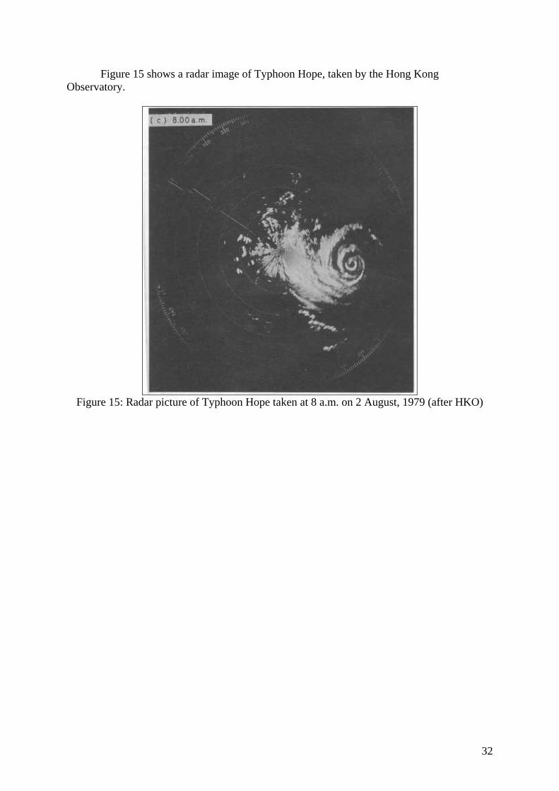
32
Figure 15 shows a radar image of Typhoon Hope, taken by the Hong Kong Observatory.
Figure 15: Radar picture of Typhoon Hope taken at 8 a.m. on 2 August, 1979 (after HKO)
33
TYPHOON ROSE (1971)
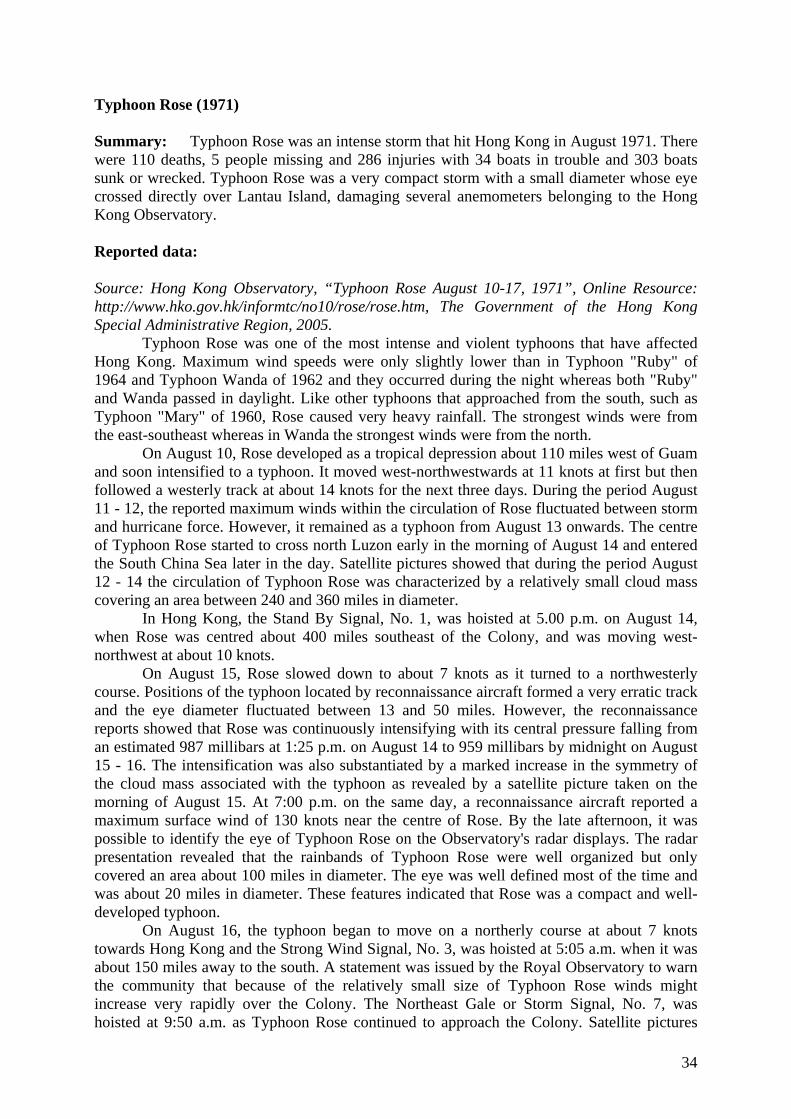
34
Typhoon Rose (1971) Summary: Typhoon Rose was an intense storm that hit Hong Kong in August 1971. There were 110 deaths, 5 people missing and 286 injuries with 34 boats in trouble and 303 boats sunk or wrecked. Typhoon Rose was a very compact storm with a small diameter whose eye crossed directly over Lantau Island, damaging several anemometers belonging to the Hong Kong Observatory. Reported data: Source: Hong Kong Observatory, “Typhoon Rose August 10-17, 1971”, Online Resource: http://www.hko.gov.hk/informtc/no10/rose/rose.htm, The Government of the Hong Kong Special Administrative Region, 2005.
Typhoon Rose was one of the most intense and violent typhoons that have affected Hong Kong. Maximum wind speeds were only slightly lower than in Typhoon "Ruby" of 1964 and Typhoon Wanda of 1962 and they occurred during the night whereas both "Ruby" and Wanda passed in daylight. Like other typhoons that approached from the south, such as Typhoon "Mary" of 1960, Rose caused very heavy rainfall. The strongest winds were from the east-southeast whereas in Wanda the strongest winds were from the north.
On August 10, Rose developed as a tropical depression about 110 miles west of Guam and soon intensified to a typhoon. It moved west-northwestwards at 11 knots at first but then followed a westerly track at about 14 knots for the next three days. During the period August 11 - 12, the reported maximum winds within the circulation of Rose fluctuated between storm and hurricane force. However, it remained as a typhoon from August 13 onwards. The centre of Typhoon Rose started to cross north Luzon early in the morning of August 14 and entered the South China Sea later in the day. Satellite pictures showed that during the period August 12 - 14 the circulation of Typhoon Rose was characterized by a relatively small cloud mass covering an area between 240 and 360 miles in diameter.
In Hong Kong, the Stand By Signal, No. 1, was hoisted at 5.00 p.m. on August 14, when Rose was centred about 400 miles southeast of the Colony, and was moving west-northwest at about 10 knots.
On August 15, Rose slowed down to about 7 knots as it turned to a northwesterly course. Positions of the typhoon located by reconnaissance aircraft formed a very erratic track and the eye diameter fluctuated between 13 and 50 miles. However, the reconnaissance reports showed that Rose was continuously intensifying with its central pressure falling from an estimated 987 millibars at 1:25 p.m. on August 14 to 959 millibars by midnight on August 15 - 16. The intensification was also substantiated by a marked increase in the symmetry of the cloud mass associated with the typhoon as revealed by a satellite picture taken on the morning of August 15. At 7:00 p.m. on the same day, a reconnaissance aircraft reported a maximum surface wind of 130 knots near the centre of Rose. By the late afternoon, it was possible to identify the eye of Typhoon Rose on the Observatory's radar displays. The radar presentation revealed that the rainbands of Typhoon Rose were well organized but only covered an area about 100 miles in diameter. The eye was well defined most of the time and was about 20 miles in diameter. These features indicated that Rose was a compact and well-developed typhoon.
On August 16, the typhoon began to move on a northerly course at about 7 knots towards Hong Kong and the Strong Wind Signal, No. 3, was hoisted at 5:05 a.m. when it was about 150 miles away to the south. A statement was issued by the Royal Observatory to warn the community that because of the relatively small size of Typhoon Rose winds might increase very rapidly over the Colony. The Northeast Gale or Storm Signal, No. 7, was hoisted at 9:50 a.m. as Typhoon Rose continued to approach the Colony. Satellite pictures
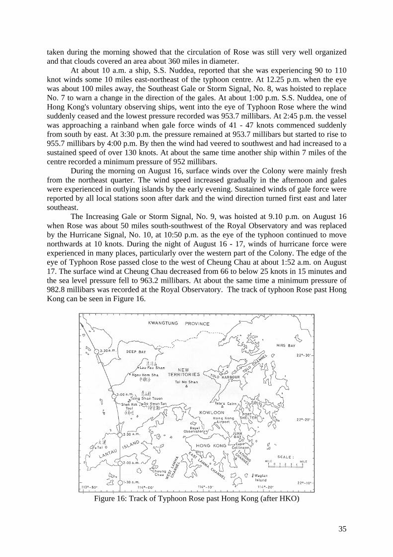
35
taken during the morning showed that the circulation of Rose was still very well organized and that clouds covered an area about 360 miles in diameter.
At about 10 a.m. a ship, S.S. Nuddea, reported that she was experiencing 90 to 110 knot winds some 10 miles east-northeast of the typhoon centre. At 12.25 p.m. when the eye was about 100 miles away, the Southeast Gale or Storm Signal, No. 8, was hoisted to replace No. 7 to warn a change in the direction of the gales. At about 1:00 p.m. S.S. Nuddea, one of Hong Kong's voluntary observing ships, went into the eye of Typhoon Rose where the wind suddenly ceased and the lowest pressure recorded was 953.7 millibars. At 2:45 p.m. the vessel was approaching a rainband when gale force winds of 41 - 47 knots commenced suddenly from south by east. At 3:30 p.m. the pressure remained at 953.7 millibars but started to rise to 955.7 millibars by 4:00 p.m. By then the wind had veered to southwest and had increased to a sustained speed of over 130 knots. At about the same time another ship within 7 miles of the centre recorded a minimum pressure of 952 millibars.
During the morning on August 16, surface winds over the Colony were mainly fresh from the northeast quarter. The wind speed increased gradually in the afternoon and gales were experienced in outlying islands by the early evening. Sustained winds of gale force were reported by all local stations soon after dark and the wind direction turned first east and later southeast.
The Increasing Gale or Storm Signal, No. 9, was hoisted at 9.10 p.m. on August 16 when Rose was about 50 miles south-southwest of the Royal Observatory and was replaced by the Hurricane Signal, No. 10, at 10:50 p.m. as the eye of the typhoon continued to move northwards at 10 knots. During the night of August 16 - 17, winds of hurricane force were experienced in many places, particularly over the western part of the Colony. The edge of the eye of Typhoon Rose passed close to the west of Cheung Chau at about 1:52 a.m. on August 17. The surface wind at Cheung Chau decreased from 66 to below 25 knots in 15 minutes and the sea level pressure fell to 963.2 millibars. At about the same time a minimum pressure of 982.8 millibars was recorded at the Royal Observatory. The track of typhoon Rose past Hong Kong can be seen in Figure 16.
Figure 16: Track of Typhoon Rose past Hong Kong (after HKO)
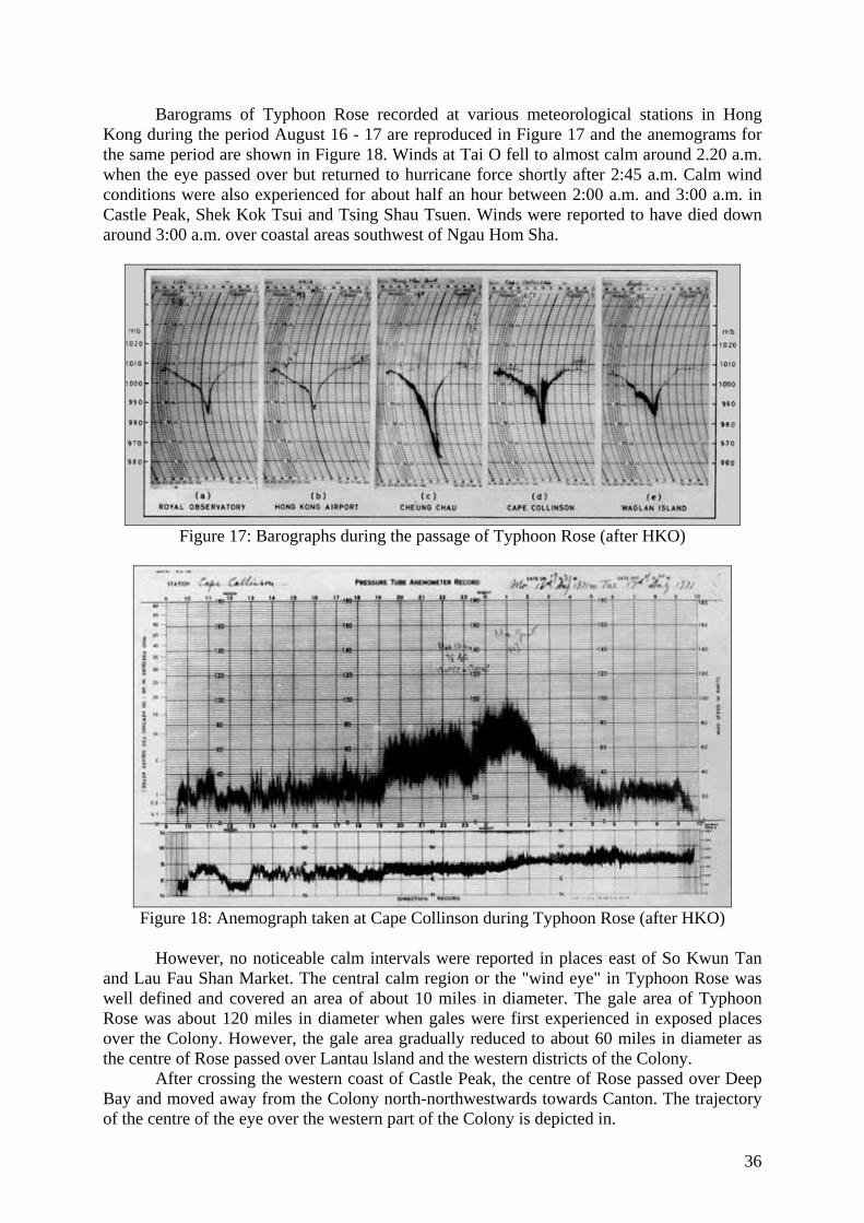
36
Barograms of Typhoon Rose recorded at various meteorological stations in Hong Kong during the period August 16 - 17 are reproduced in Figure 17 and the anemograms for the same period are shown in Figure 18. Winds at Tai O fell to almost calm around 2.20 a.m. when the eye passed over but returned to hurricane force shortly after 2:45 a.m. Calm wind conditions were also experienced for about half an hour between 2:00 a.m. and 3:00 a.m. in Castle Peak, Shek Kok Tsui and Tsing Shau Tsuen. Winds were reported to have died down around 3:00 a.m. over coastal areas southwest of Ngau Hom Sha.
Figure 17: Barographs during the passage of Typhoon Rose (after HKO)
Figure 18: Anemograph taken at Cape Collinson during Typhoon Rose (after HKO)
However, no noticeable calm intervals were reported in places east of So Kwun Tan
and Lau Fau Shan Market. The central calm region or the "wind eye" in Typhoon Rose was well defined and covered an area of about 10 miles in diameter. The gale area of Typhoon Rose was about 120 miles in diameter when gales were first experienced in exposed places over the Colony. However, the gale area gradually reduced to about 60 miles in diameter as the centre of Rose passed over Lantau lsland and the western districts of the Colony.
After crossing the western coast of Castle Peak, the centre of Rose passed over Deep Bay and moved away from the Colony north-northwestwards towards Canton. The trajectory of the centre of the eye over the western part of the Colony is depicted in.
37
As the typhoon began to weaken overland, No. 10 was replaced by the Southwest Gale or Storm Signal, No. 6, at 4:40 a.m. This was followed by the Strong Wind Signal, No. 3, at 9:15 a.m. All signals were lowered at noon on August 17.
Rose weakened to a tropical storm at about noon on August 17 and dissipated near Canton about 110 miles north-northwest of the Colony. Fresh southerly winds prevailed over the Colony for several hours in the early afternoon.
During the passage of Rose, there were 6 hours of gales at the Royal Observatory, while hurricane force winds were recorded for 1 hour at the Hong Kong Airport, 2 hours at Cape Collinson and Waglan lsland, 3 hours at Cheung Chau, and 4 hours at Tate's Cairn. The maximum gust peak speeds recorded were 102 knots at Waglan Island, 103 knots at Cape Collinson, 105 knots at Cheung Chau, and 121 knots at the Royal Observatory. At the top of Tai Mo Shan, a maximum gust peak speed of 150 knots was recorded at 1.43 a.m. just before the anemometer was broken at 2:11 a.m. on August 17.
The weather in Hong Kong was cloudy with scattered showers on the morning of August 16, but the showers became frequent and squally during the day and heavy rain set in towards midnight. Torrential rain occurred during the early morning of August 17 and a total of 167.5 mm of rainfall was recorded at the Royal Observatory in the three hours between 1.00 a.m. and 4.00 a.m. Brilliant flashes of lightning were also observed at this time but because of the noise caused by the wind no thunder could be heard at the observing stations. During the heavy rain on August 17 the trace of the "Jardi" rate-of-rainfall recorder at Tate's Cairn rose to above the upper limit of the chart and the maximum instantaneous rate which occurred around 8.30 a.m. was estimated to be 513 mm/h. The weather improved rapidly during the afternoon of August 17 and no rainfall was recorded after 5:00 p.m.
Figure 19: Rainfall and pressure readings at the ROHK Headquarters (after HKO) An unusual phenomenon observed was the development of sea fog at Waglan lsland,
Cheung Chau and Cape Collinson during the morning of August 18. This was probably caused by a lowering of the sea surface temperature by Typhoon Rose. Fog is rare in Hong Kong in August.
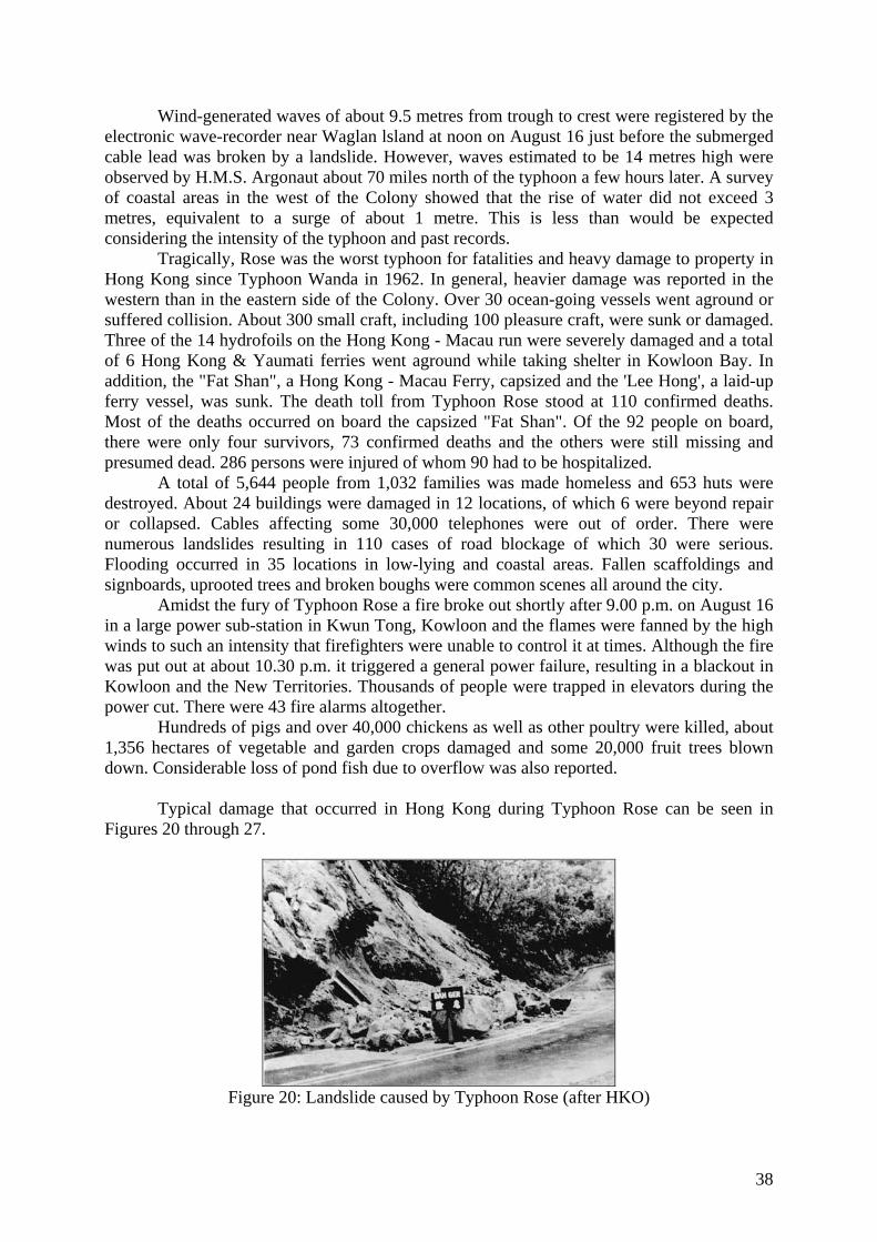
38
Wind-generated waves of about 9.5 metres from trough to crest were registered by the electronic wave-recorder near Waglan lsland at noon on August 16 just before the submerged cable lead was broken by a landslide. However, waves estimated to be 14 metres high were observed by H.M.S. Argonaut about 70 miles north of the typhoon a few hours later. A survey of coastal areas in the west of the Colony showed that the rise of water did not exceed 3 metres, equivalent to a surge of about 1 metre. This is less than would be expected considering the intensity of the typhoon and past records.
Tragically, Rose was the worst typhoon for fatalities and heavy damage to property in Hong Kong since Typhoon Wanda in 1962. In general, heavier damage was reported in the western than in the eastern side of the Colony. Over 30 ocean-going vessels went aground or suffered collision. About 300 small craft, including 100 pleasure craft, were sunk or damaged. Three of the 14 hydrofoils on the Hong Kong - Macau run were severely damaged and a total of 6 Hong Kong & Yaumati ferries went aground while taking shelter in Kowloon Bay. In addition, the "Fat Shan", a Hong Kong - Macau Ferry, capsized and the 'Lee Hong', a laid-up ferry vessel, was sunk. The death toll from Typhoon Rose stood at 110 confirmed deaths. Most of the deaths occurred on board the capsized "Fat Shan". Of the 92 people on board, there were only four survivors, 73 confirmed deaths and the others were still missing and presumed dead. 286 persons were injured of whom 90 had to be hospitalized.
A total of 5,644 people from 1,032 families was made homeless and 653 huts were destroyed. About 24 buildings were damaged in 12 locations, of which 6 were beyond repair or collapsed. Cables affecting some 30,000 telephones were out of order. There were numerous landslides resulting in 110 cases of road blockage of which 30 were serious. Flooding occurred in 35 locations in low-lying and coastal areas. Fallen scaffoldings and signboards, uprooted trees and broken boughs were common scenes all around the city.
Amidst the fury of Typhoon Rose a fire broke out shortly after 9.00 p.m. on August 16 in a large power sub-station in Kwun Tong, Kowloon and the flames were fanned by the high winds to such an intensity that firefighters were unable to control it at times. Although the fire was put out at about 10.30 p.m. it triggered a general power failure, resulting in a blackout in Kowloon and the New Territories. Thousands of people were trapped in elevators during the power cut. There were 43 fire alarms altogether.
Hundreds of pigs and over 40,000 chickens as well as other poultry were killed, about 1,356 hectares of vegetable and garden crops damaged and some 20,000 fruit trees blown down. Considerable loss of pond fish due to overflow was also reported.
Typical damage that occurred in Hong Kong during Typhoon Rose can be seen in Figures 20 through 27.
Figure 20: Landslide caused by Typhoon Rose (after HKO)
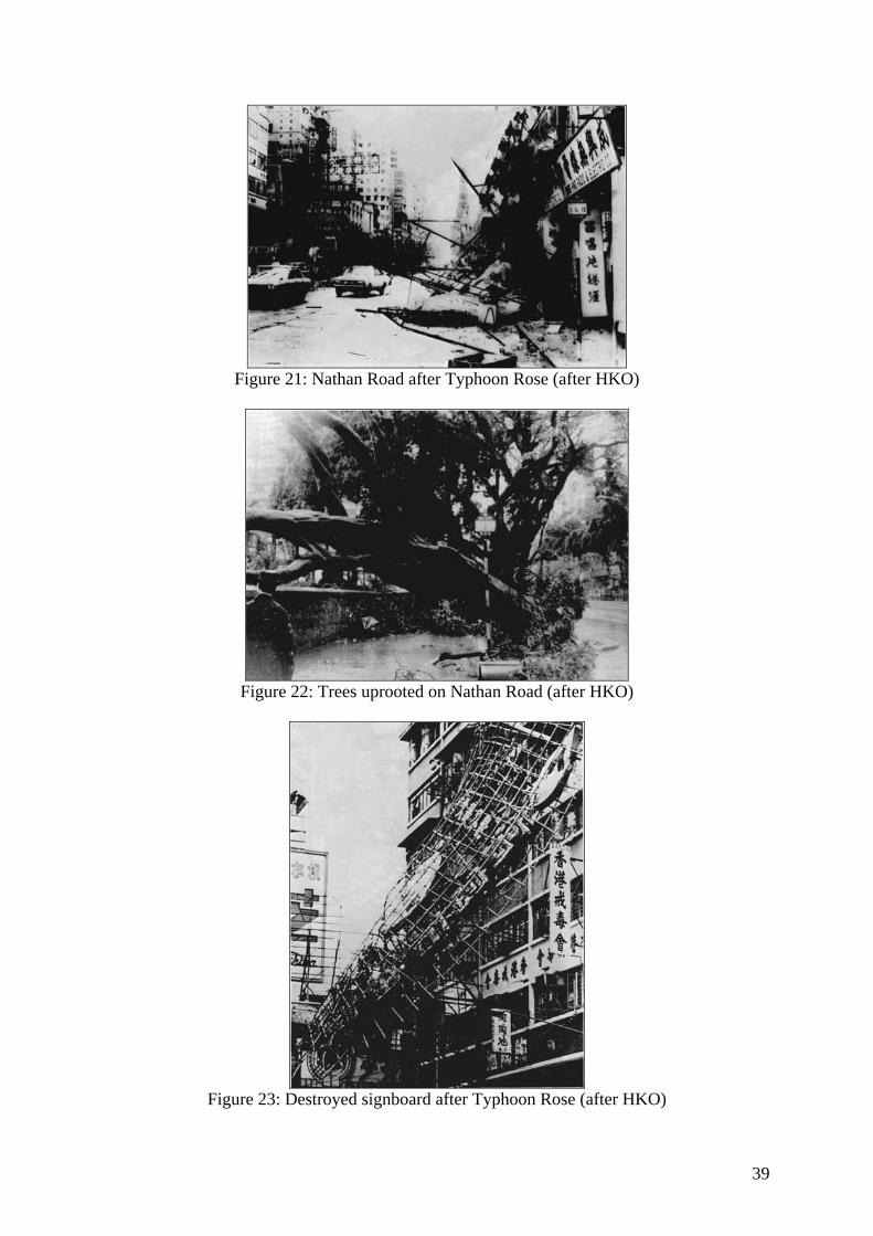
39
Figure 21: Nathan Road after Typhoon Rose (after HKO)
Figure 22: Trees uprooted on Nathan Road (after HKO)
Figure 23: Destroyed signboard after Typhoon Rose (after HKO)
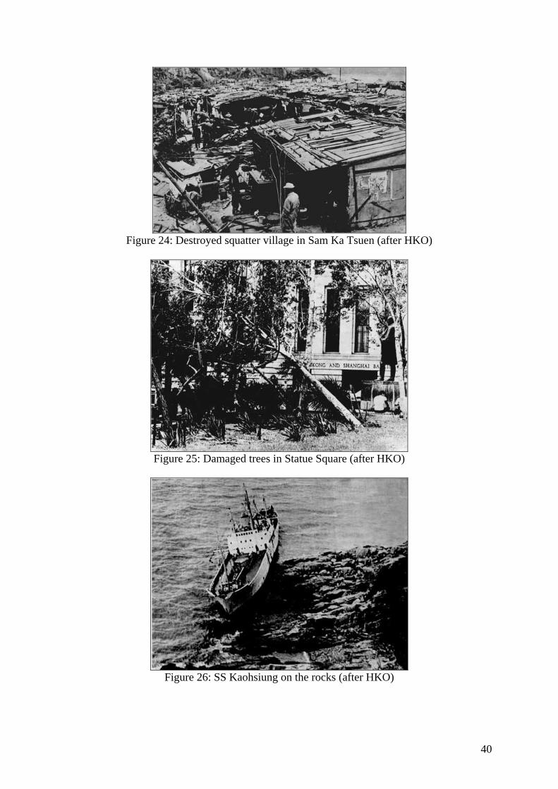
40
Figure 24: Destroyed squatter village in Sam Ka Tsuen (after HKO)
Figure 25: Damaged trees in Statue Square (after HKO)
Figure 26: SS Kaohsiung on the rocks (after HKO)
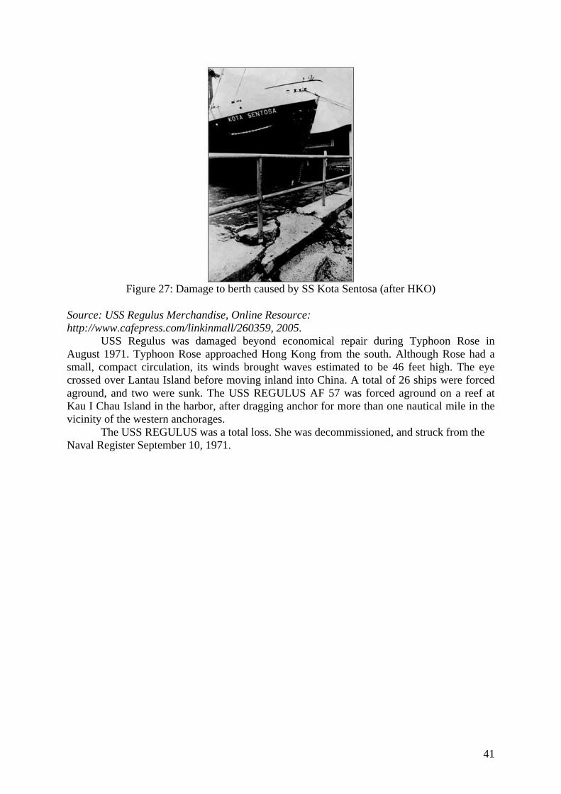
41
Figure 27: Damage to berth caused by SS Kota Sentosa (after HKO)
Source: USS Regulus Merchandise, Online Resource: http://www.cafepress.com/linkinmall/260359, 2005.
USS Regulus was damaged beyond economical repair during Typhoon Rose in August 1971. Typhoon Rose approached Hong Kong from the south. Although Rose had a small, compact circulation, its winds brought waves estimated to be 46 feet high. The eye crossed over Lantau Island before moving inland into China. A total of 26 ships were forced aground, and two were sunk. The USS REGULUS AF 57 was forced aground on a reef at Kau I Chau Island in the harbor, after dragging anchor for more than one nautical mile in the vicinity of the western anchorages.
The USS REGULUS was a total loss. She was decommissioned, and struck from the Naval Register September 10, 1971.
42
TYPHOON WANDA (1962)
43
Typhoon Wanda (1962) Summary: Typhoon Wanda hit Hong Kong during August and September 1962. It was the only severe typhoon to affect Hong Kong that year. However, it did cause an extensive amount of damage with 130 people killed, 53 missing, 36 ocean-going vessels were in trouble, 1297 small boats were sunk or wrecked and 756 boats were damaged. Typhoon Wanda was one of the most destructive typhoons in Hong Kong history. Reported data: Source: Hong Kong Observatory, “Typhoon Wanda August 27 – September 2, 1962”, Online Resource: http://www.weather.gov.hk/informtc/no10/wanda/wanda.htm, The Government of the Hong Kong Special Administrative Region, 2005.
Wanda formed on August 27 as a tropical depression over the Pacific about 1,300 miles to the east-southeast of Hong Kong. Moving west-northwest towards the Luzon Strait at fifteen knots it gradually intensified and by the next day was a severe tropical storm.
On August 29 a U.S.A.F. reconnaissance aircraft flew into the eye of the storm and reported that the wind strength had reached hurricane force. By this time the circulation of the typhoon covered a wide area about 1,000 miles across.
Another aircraft reconnaissance on August 30 indicated that further intensification had occurred and 80 knot winds were reported near the centre. It continued to move towards Hong Kong and by the evening it was centred 400 miles east-southeast of the Colony, over the southern part of the Luzon Strait. No. 1 Local Storm Signal was hoisted at 7:45 p.m.
Up to this time the winds over the Colony had been generally light or moderate but early the next morning they set in from the north and showed signs of freshening. The No. 3 Local Storm Signal was hoisted at 4:10 p.m. on August 31.
The first rain came with a squall of north-northwest winds which moved west across the Colony during the early evening. By 9 a.m. typhoon Wanda was centred about 155 miles east-southeast of the Colony and was moving west or west-northwest at 10 knots. Although no strong winds had yet been reported it became certain that Wanda would pass close to the Colony the next day and No. 7 signal was hoisted at 10:50 p.m. The wind speed reached gale force with gusts to 48 knots at Waglan Island at 2:00 a.m. on September 1 when Wanda was centred about 105 miles away.
At 4:15 a.m. No. 9 Local Storm Signal was hoisted to indicate that the gales were expected to increase. By this time winds over the harbour were averaging about 30 knots from the north-northwest but Waglan Island was reporting 40 knots with gusts to 57 knots.
No. 10 Local Storm Signal was hoisted at 6:15 a.m. on September 1 when Wanda was centred some 50 miles away and moving directly towards the Colony. As the approach coincided with high tide, a warning was issued at 6:30 a.m. stating that the water would rise 6 feet above normal high tide in the harbour and much higher in Tolo Harbour with flooding over low-lying land.
By 9 a.m. typhoon Wanda was centred over the eastern waters of the Colony and hurricane force winds were blowing over most of Hong Kong. Gusts of 116 knots were reported from Waglan Island and 154 knots from Tate's Cairn. Figures 28 and 29 are the anemogram and barograph, respectively, from the Royal Observatory. It shows that the 10 minute mean wind reached typhoon force at about 9.20 a.m. and rose to a maximum of about 78 knots at about 9.30. a.m. It decreased slightly as the eye passed and then increased again to about 74 knots at 10.00 a.m. At about 9.30 a.m. a maximum gust of 140 knots was recorded at the Royal Observatory as the typhoon centre was passing south of Waglan Island. The track of Typhoon Wanda can be seen in Figure 30.
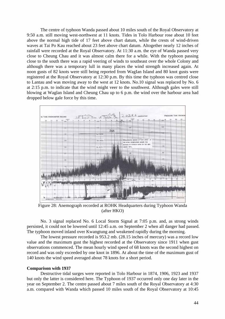
44
The centre of typhoon Wanda passed about 10 miles south of the Royal Observatory at 9:50 a.m. still moving west-northwest at 11 knots. Tides in Tolo Harbour rose about 10 feet above the normal high tide of 17 feet above chart datum, while the crests of wind-driven waves at Tai Po Kau reached about 23 feet above chart datum. Altogether nearly 12 inches of rainfall were recorded at the Royal Observatory. At 11:30 a.m. the eye of Wanda passed very close to Cheung Chau and it was almost calm there for a while. With the typhoon passing close to the south there was a rapid veering of winds to southeast over the whole Colony and although there was a temporary lull in many places the wind strength increased again. At noon gusts of 82 knots were still being reported from WagIan Island and 80 knot gusts were registered at the Royal Observatory at 12:30 p.m. By this time the typhoon was centred close to Lantau and was moving away to the west at 12 knots. No.10 signal was replaced by No. 6 at 2:15 p.m. to indicate that the wind might veer to the southwest. Although gales were still blowing at Waglan Island and Cheung Chau up to 6 p.m. the wind over the harbour area had dropped below gale force by this time.
Figure 28: Anemograph recorded at ROHK Headquarters during Typhoon Wanda
(after HKO)
No. 3 signal replaced No. 6 Local Storm Signal at 7:05 p.m. and, as strong winds persisted, it could not be lowered until 12:45 a.m. on September 2 when all danger had passed. The typhoon moved inland over Kwangtung and weakened rapidly during the morning.
The lowest pressure recorded is 953.2 mb. (28.15 inches of mercury) was a record low value and the maximum gust the highest recorded at the Observatory since 1911 when gust observations commenced. The mean hourly wind speed of 68 knots was the second highest on record and was only exceeded by one knot in 1896. At about the time of the maximum gust of 140 knots the wind speed averaged about 78 knots for a short period.
Comparison with 1937
Destructive tidal surges were reported in Tolo Harbour in 1874, 1906, 1923 and 1937 but only the latter is considered here. The Typhoon of 1937 occurred only one day later in the year on September 2. The centre passed about 7 miles south of the Royal Observatory at 4:30 a.m. compared with Wanda which passed 10 miles south of the Royal Observatory at 10:45
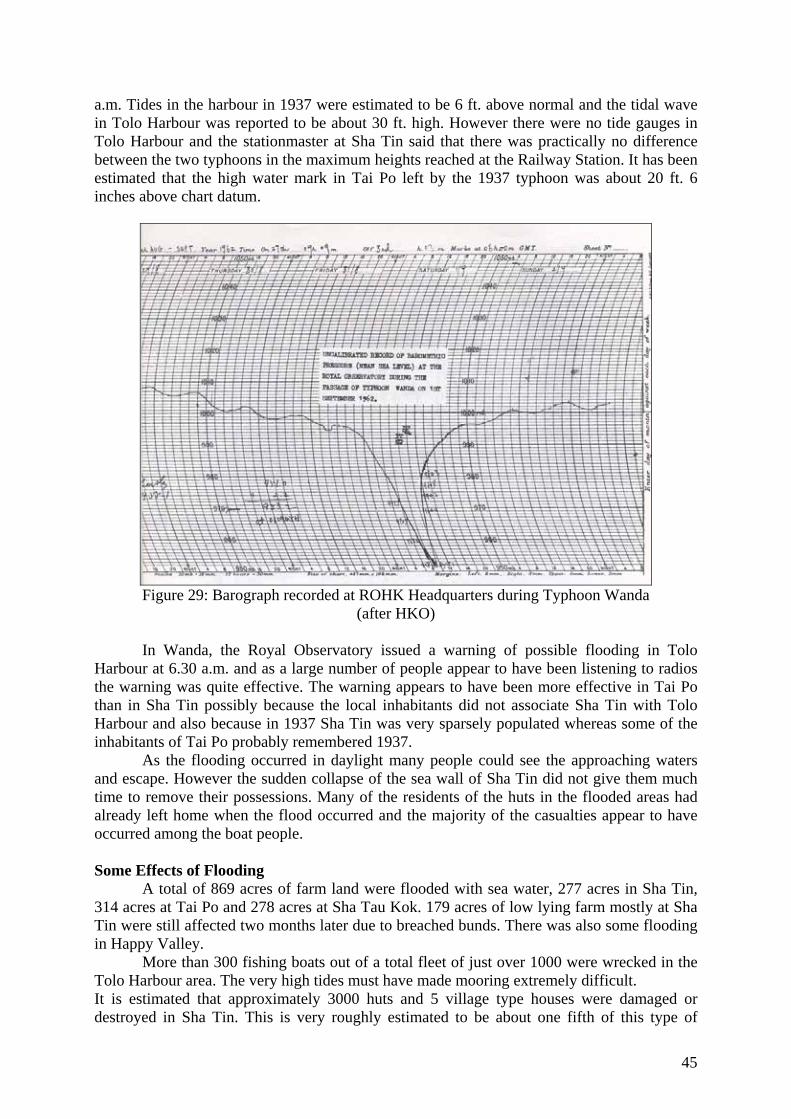
45
a.m. Tides in the harbour in 1937 were estimated to be 6 ft. above normal and the tidal wave in Tolo Harbour was reported to be about 30 ft. high. However there were no tide gauges in Tolo Harbour and the stationmaster at Sha Tin said that there was practically no difference between the two typhoons in the maximum heights reached at the Railway Station. It has been estimated that the high water mark in Tai Po left by the 1937 typhoon was about 20 ft. 6 inches above chart datum.
Figure 29: Barograph recorded at ROHK Headquarters during Typhoon Wanda
(after HKO)
In Wanda, the Royal Observatory issued a warning of possible flooding in Tolo Harbour at 6.30 a.m. and as a large number of people appear to have been listening to radios the warning was quite effective. The warning appears to have been more effective in Tai Po than in Sha Tin possibly because the local inhabitants did not associate Sha Tin with Tolo Harbour and also because in 1937 Sha Tin was very sparsely populated whereas some of the inhabitants of Tai Po probably remembered 1937.
As the flooding occurred in daylight many people could see the approaching waters and escape. However the sudden collapse of the sea wall of Sha Tin did not give them much time to remove their possessions. Many of the residents of the huts in the flooded areas had already left home when the flood occurred and the majority of the casualties appear to have occurred among the boat people. Some Effects of Flooding
A total of 869 acres of farm land were flooded with sea water, 277 acres in Sha Tin, 314 acres at Tai Po and 278 acres at Sha Tau Kok. 179 acres of low lying farm mostly at Sha Tin were still affected two months later due to breached bunds. There was also some flooding in Happy Valley.
More than 300 fishing boats out of a total fleet of just over 1000 were wrecked in the Tolo Harbour area. The very high tides must have made mooring extremely difficult. It is estimated that approximately 3000 huts and 5 village type houses were damaged or destroyed in Sha Tin. This is very roughly estimated to be about one fifth of this type of
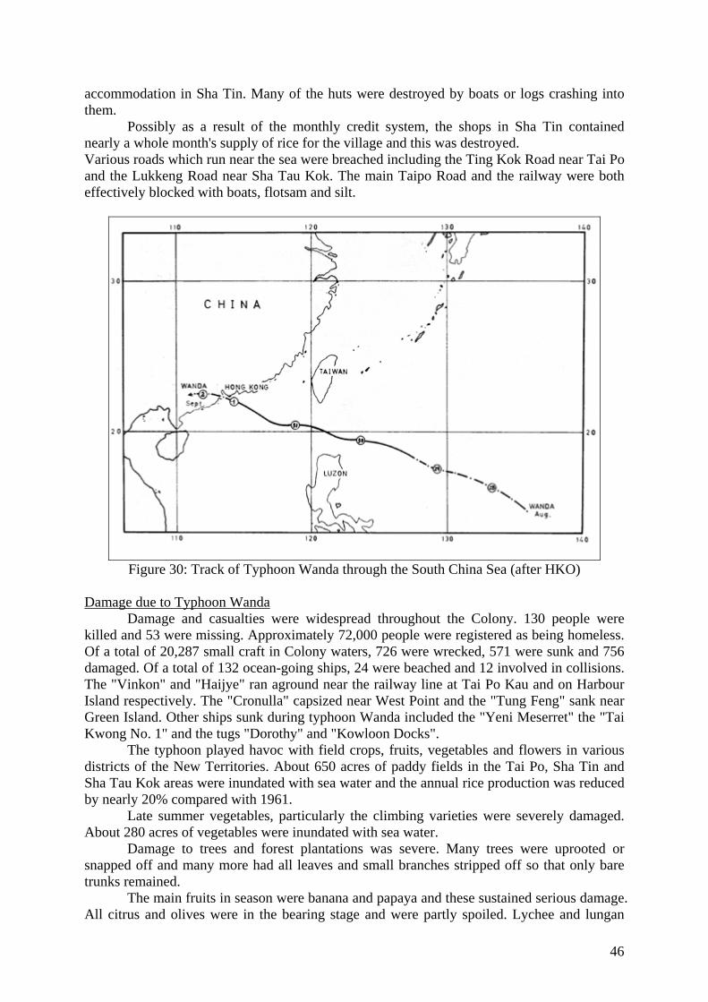
46
accommodation in Sha Tin. Many of the huts were destroyed by boats or logs crashing into them.
Possibly as a result of the monthly credit system, the shops in Sha Tin contained nearly a whole month's supply of rice for the village and this was destroyed. Various roads which run near the sea were breached including the Ting Kok Road near Tai Po and the Lukkeng Road near Sha Tau Kok. The main Taipo Road and the railway were both effectively blocked with boats, flotsam and silt.
Figure 30: Track of Typhoon Wanda through the South China Sea (after HKO)
Damage due to Typhoon Wanda
Damage and casualties were widespread throughout the Colony. 130 people were killed and 53 were missing. Approximately 72,000 people were registered as being homeless. Of a total of 20,287 small craft in Colony waters, 726 were wrecked, 571 were sunk and 756 damaged. Of a total of 132 ocean-going ships, 24 were beached and 12 involved in collisions. The "Vinkon" and "Haijye" ran aground near the railway line at Tai Po Kau and on Harbour Island respectively. The "Cronulla" capsized near West Point and the "Tung Feng" sank near Green Island. Other ships sunk during typhoon Wanda included the "Yeni Meserret" the "Tai Kwong No. 1" and the tugs "Dorothy" and "Kowloon Docks".
The typhoon played havoc with field crops, fruits, vegetables and flowers in various districts of the New Territories. About 650 acres of paddy fields in the Tai Po, Sha Tin and Sha Tau Kok areas were inundated with sea water and the annual rice production was reduced by nearly 20% compared with 1961.
Late summer vegetables, particularly the climbing varieties were severely damaged. About 280 acres of vegetables were inundated with sea water.
Damage to trees and forest plantations was severe. Many trees were uprooted or snapped off and many more had all leaves and small branches stripped off so that only bare trunks remained.
The main fruits in season were banana and papaya and these sustained serious damage. All citrus and olives were in the bearing stage and were partly spoiled. Lychee and lungan
47
were the least affected. As a whole, damage to fruit trees was about 10% ranging from the extremes of 5% in the case of lychee and lungan to 75% in the case of banana.
Flowers in exposed or flooded places sustained severe damage. In the Sha Tin and Tai Po districts, gladioli grown in low lying land suffered root rot. Soon after the typhoon flower growers were busy preparing their land for cultivating various flower crops, particularly gladioli for Christmas sales.
Storm damage to paddy was slight. With continuing heavy rains, the damage caused by salt water did not have a lasting effect.
A great number of livestock houses were damaged by the typhoon and livestock losses were severe in some places. Egg production was greatly reduced. Many farm houses were damaged but only a small proportion was beyond repair.
A large number of cars were damaged during typhoon Wanda, mostly with broken windscreens, but a few sustained more serious damage.
Property damage caused by the typhoon was never completely assessed. The urban areas were littered with debris, galvanized iron sheets, bamboo scaffolding, advertisement sign boards, overhead wires and broken windows. More than 700 squatter and roof top huts were destroyed and 1,300 made uninhabitable. Numerous houses collapsed and in Shau Kei Wan many squatter boats were wrecked by logs that had broken adrift from nearby timber yards. In addition over 400 huts in cottage areas were destroyed and 1,200 damaged.
48
TYPHOON MARY (1960)
49
Typhoon Mary (1960) Summary: Typhoon Mary struck Hong Kong in June 1960. The winds from Typhoon Mary were not in fact strong enough to warrant a Number 10 signal, however, this warning was raised by the Hong Kong Observatory. The damage amounted to 45 people killed, 11 missing, 127 people injured, 6 ocean-going vessels in trouble, 352 small craft sunk or wrecked and 462 small craft damaged. Reported data: Source: Hong Kong Observatory, “Typhoon Mary 3 – 12 June, 1960”, Online Resource: http://www.hko.gov.hk/informtc/no10/mary.htm, The Government of the Hong Kong Special Administrative Region, 2005.
Mary formed as a tropical depression south of Hong Kong on June 3rd and intensified to a severe tropical storm on the 5th. It moved northwards on the 6th, weakened on the 7th, but re-intensified on the 8th. It passed northward over the western New Territories on the early morning on the 9th, causing considerable loss of life and damage to property. From the 4th to the 7th winds were intermittently strong at the Royal Observatory and continuously strong offshore, gales becoming general by 6 p.m. on the 8th. No winds of typhoon strength were sustained at the Royal Observatory for as long as one minute, but a maximum gust of 103 knots was recorded. At Waglan Island where the anemometer is 230 feet above mean sea level and very exposed, winds averaged 64 knots (typhoon strength) for very short periods with gusts to 105 knots. The storm centre passed close to Cheung Chau between 4 a.m. and 6 a.m. on the 9th. Mean winds there did not exceed 47 knots, but they changed to southwesterly, a direction from which the anchorages and villages are badly exposed. The use of No. 10 signal was not strictly justified according to international procedures, since sustained surface winds of 64 knots were not observed. 16.83 inches of rain were recorded at the Observatory while local signals were hoisted. Source: Online Resource: http://stableshistory.co.uk/brian_stables_b_1929_p12.htm, 2005.
There was a particularly nasty Typhoon that passed over us, and once again I was able to experience ‘the eye of the storm’, this time, thankfully, I was on land and so was able to be a lot braver about it. This was Typhoon Mary, and she was vicious. It was interesting that all the, (four,) typhoons I experienced, (two centers and two edges,) the sky of the previous evening was a beautiful bright burnished brassy gold, so bright it hurt the eyes. It was the first typhoon center that had passed over the Colony for many years.
We lived six stories up and our apartment had metal framed ‘storm proof’ windows. We got flooded out. Although the glass remained intact, the frames became distorted with the force of the winds and the water gushed through, I had to open the door and let it escape down the stairs and elevator shaft. The wind was so strong that a freighter in the harbour was lifted out of the water and deposited on the side of the runway at Kai Tak airport. Many people died, and hundreds more rendered homeless mainly due to mudslides where the poorer element of the population lived on the mountainsides.
With all this wind and rain you would not expect that such a thing as a water shortage would be possible, but this was indeed the situation. The colony had expanded its population so quickly through immigration, mostly illegal from China, that the water supplies were less than adequate and water rationing was imposed. The way it was done was to make water available only between six o-clock in the morning until it was turned off three hours later. In a climate like that it was rather inconvenient but we coped by filling buckets and pans.
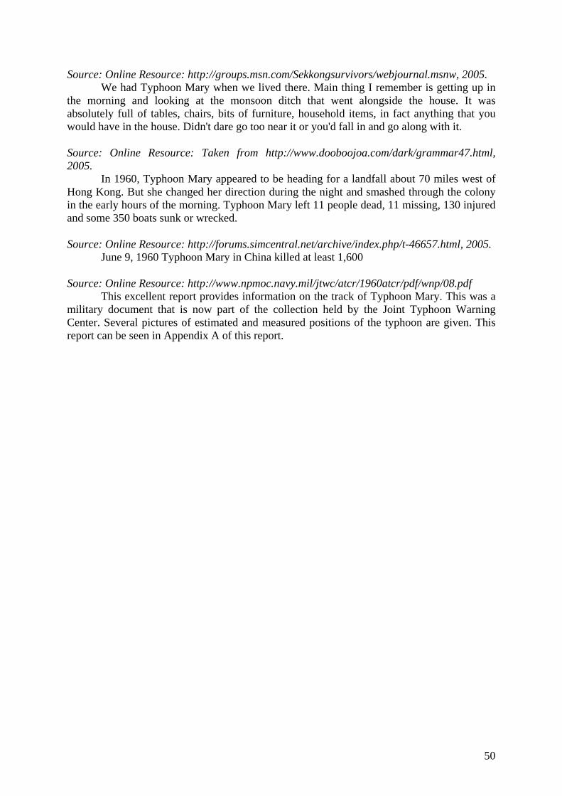
50
Source: Online Resource: http://groups.msn.com/Sekkongsurvivors/webjournal.msnw, 2005. We had Typhoon Mary when we lived there. Main thing I remember is getting up in
the morning and looking at the monsoon ditch that went alongside the house. It was absolutely full of tables, chairs, bits of furniture, household items, in fact anything that you would have in the house. Didn't dare go too near it or you'd fall in and go along with it. Source: Online Resource: Taken from http://www.dooboojoa.com/dark/grammar47.html, 2005.
In 1960, Typhoon Mary appeared to be heading for a landfall about 70 miles west of Hong Kong. But she changed her direction during the night and smashed through the colony in the early hours of the morning. Typhoon Mary left 11 people dead, 11 missing, 130 injured and some 350 boats sunk or wrecked. Source: Online Resource: http://forums.simcentral.net/archive/index.php/t-46657.html, 2005.
June 9, 1960 Typhoon Mary in China killed at least 1,600 Source: Online Resource: http://www.npmoc.navy.mil/jtwc/atcr/1960atcr/pdf/wnp/08.pdf This excellent report provides information on the track of Typhoon Mary. This was a military document that is now part of the collection held by the Joint Typhoon Warning Center. Several pictures of estimated and measured positions of the typhoon are given. This report can be seen in Appendix A of this report.
51
The TYPHOON of 1937
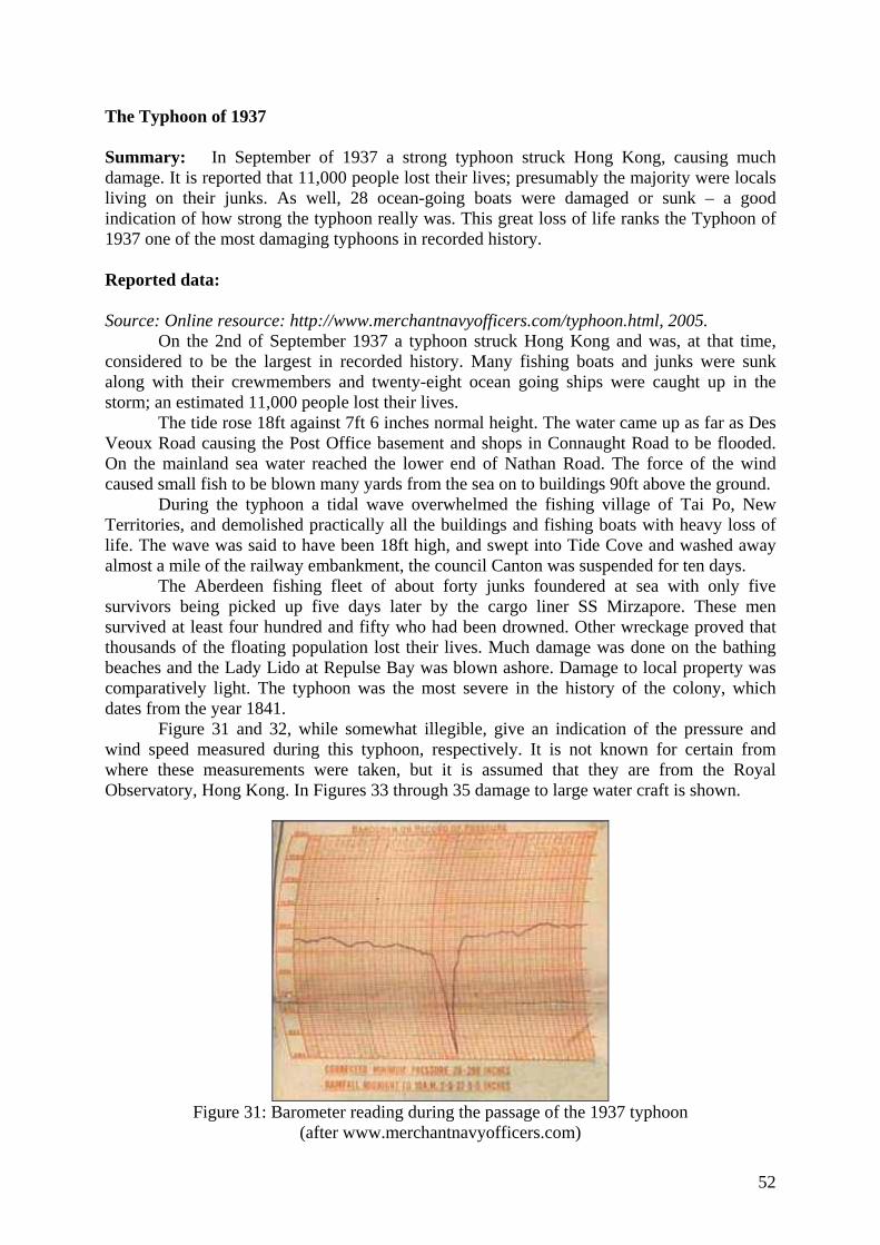
52
The Typhoon of 1937 Summary: In September of 1937 a strong typhoon struck Hong Kong, causing much damage. It is reported that 11,000 people lost their lives; presumably the majority were locals living on their junks. As well, 28 ocean-going boats were damaged or sunk – a good indication of how strong the typhoon really was. This great loss of life ranks the Typhoon of 1937 one of the most damaging typhoons in recorded history. Reported data: Source: Online resource: http://www.merchantnavyofficers.com/typhoon.html, 2005.
On the 2nd of September 1937 a typhoon struck Hong Kong and was, at that time, considered to be the largest in recorded history. Many fishing boats and junks were sunk along with their crewmembers and twenty-eight ocean going ships were caught up in the storm; an estimated 11,000 people lost their lives.
The tide rose 18ft against 7ft 6 inches normal height. The water came up as far as Des Veoux Road causing the Post Office basement and shops in Connaught Road to be flooded. On the mainland sea water reached the lower end of Nathan Road. The force of the wind caused small fish to be blown many yards from the sea on to buildings 90ft above the ground.
During the typhoon a tidal wave overwhelmed the fishing village of Tai Po, New Territories, and demolished practically all the buildings and fishing boats with heavy loss of life. The wave was said to have been 18ft high, and swept into Tide Cove and washed away almost a mile of the railway embankment, the council Canton was suspended for ten days.
The Aberdeen fishing fleet of about forty junks foundered at sea with only five survivors being picked up five days later by the cargo liner SS Mirzapore. These men survived at least four hundred and fifty who had been drowned. Other wreckage proved that thousands of the floating population lost their lives. Much damage was done on the bathing beaches and the Lady Lido at Repulse Bay was blown ashore. Damage to local property was comparatively light. The typhoon was the most severe in the history of the colony, which dates from the year 1841. Figure 31 and 32, while somewhat illegible, give an indication of the pressure and wind speed measured during this typhoon, respectively. It is not known for certain from where these measurements were taken, but it is assumed that they are from the Royal Observatory, Hong Kong. In Figures 33 through 35 damage to large water craft is shown.
Figure 31: Barometer reading during the passage of the 1937 typhoon
(after www.merchantnavyofficers.com)
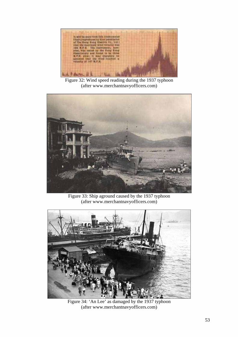
53
Figure 32: Wind speed reading during the 1937 typhoon
(after www.merchantnavyofficers.com)
Figure 33: Ship aground caused by the 1937 typhoon
(after www.merchantnavyofficers.com)
Figure 34: ‘An Lee’ as damaged by the 1937 typhoon
(after www.merchantnavyofficers.com)
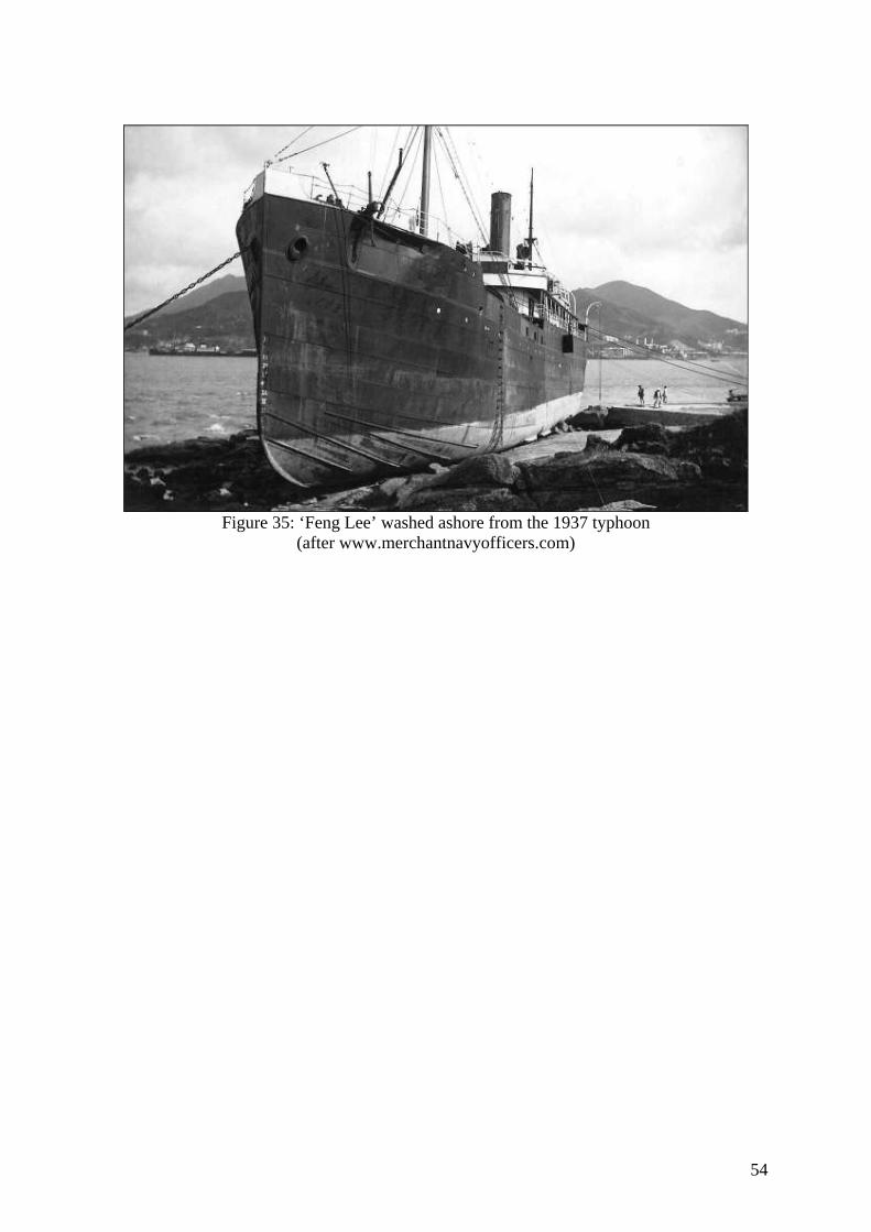
54
Figure 35: ‘Feng Lee’ washed ashore from the 1937 typhoon
(after www.merchantnavyofficers.com)
55
The TYPHOON of 1906
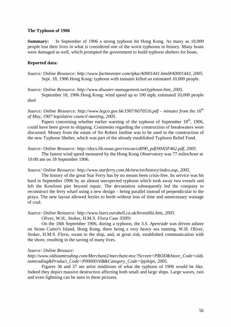
56
The Typhoon of 1906 Summary: In September of 1906 a strong typhoon hit Hong Kong. As many as 10,000 people lost their lives in what is considered one of the worst typhoons in history. Many boats were damaged as well, which prompted the government to build typhoon shelters for boats. Reported data: Source: Online Resource: http://www.factmonster.com/ipka/A0001441.html#A0001443, 2005.
Sept. 18, 1906 Hong Kong: typhoon with tsunami killed an estimated 10,000 people. Source: Online Resource: http://www.disaster-management.net/typhoon.htm, 2005.
September 18, 1906 Hong Kong: wind speed up to 100 mph, estimated 10,000 people died Source: Online Resource: http://www.legco.gov.hk/1907/h070516.pdf – minutes from the 16th of May, 1907 legislative council meeting, 2005.
Papers concerning whether earlier warning of the typhoon of September 18th, 1906, could have been given to shipping. Comments regarding the construction of breakwaters were discussed. Money from the estate of Sir Robert Jardine was to be used in the construction of the new Typhoon Shelter, which was part of the already established Typhoon Relief Fund. Source: Online Resource: http://docs.lib.noaa.gov/rescue/cd090_pdf/00A5F462.pdf, 2005.
The fastest wind speed measured by the Hong Kong Observatory was 77 miles/hour at 10:00 am on 18 September 1906. Source: Online Resource: http://www.starferry.com.hk/new/en/history/index.asp, 2005.
The history of the great Star Ferry has by no means been crisis-free. Its service was hit hard in September 1906 by an almost unexpected typhoon which took away two vessels and left the Kowloon pier beyond repair. The devastation subsequently led the company to reconstruct the ferry wharf using a new design – being parallel instead of perpendicular to the praya. The new layout allowed ferries to berth without loss of time and unnecessary wastage of coal. Source: Online Resource: http://www.lsars.eurobell.co.uk/bronz06s.htm, 2005.
Oliver, W.H., Stoker, H.M.S. Flora Case 35091 On the 18th September 1906, during a typhoon, the S.S. Apenrade was driven ashore
on Stone Cutter's Island, Hong Kong, there being a very heavy sea running. W.H. Oliver, Stoker, H.M.S. Flora, swam to the ship, and, at great risk, established communication with the shore, resulting in the saving of many lives. Source: Online Resouce: http://www.oldsiamtrading.com/Merchant2/merchant.mvc?Screen=PROD&Store_Code=oldsiamtrading&Product_Code=P0000016B&Category_Code=lpjships, 2005. Figures 36 and 37 are artist renditions of what the typhoon of 1906 would be like. Indeed they depict massive destruction affecting both small and large ships. Large waves, rain and even lightning can be seen in these pictures.
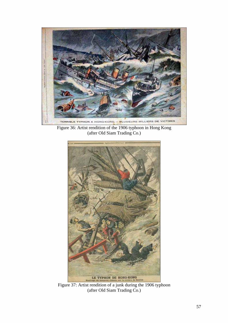
57
Figure 36: Artist rendition of the 1906 typhoon in Hong Kong
(after Old Siam Trading Co.)
Figure 37: Artist rendition of a junk during the 1906 typhoon
(after Old Siam Trading Co.)

58
The TYPHOON of 1874
59
Typhoon of 1874 Reported data: Source: Online Resource: http://www.hkoutdoors.com/Need_to_Know_Basics/Hong_Kong_weather_(and_climate)/Hong_Kong_typhoons:_hurricane_force_winds,_floods_and_storm_surges/31/, 2005.
One of Hong Kong's worst typhoons struck in 1874; according to an eyewitness, Eitel, in Europe in China (1895): "the town looked as if it had undergone a terrific bombardment. Rows of houses were unroofed, hundreds of European and Chinese dwellings were in ruins, large trees were torn out by their roots ... in every direction dead bodies were seen floating about or scattered among the ruins ... thirty-five foreign vessels, trusting in their anchors, were wrecked or badly injured." (Welsh, A History of Hong Kong.)
60
The TYPHOON of 1847
61
The Typhoon of 1847 Reported data: Source: Crook, A.H., Gibbs, L., Hong Kong: Some Early Notes on its Natural History., November 1934, Online reference: http://sunzi1.lib.hku.hk/hkjo/view/27/2700281.pdf, 2005.
“One of the most serious checks to the settlement of the new Colony was a ‘close up’ typhoon in its first year. But the destruction, damage, and loss of life caused by a typhoon, have been greatly minimized since those days by the study of typhoons, the forewarnings of their approach, the building of shelters, and other means taken to counteract their ill-effects. The description of the harbour as “exposed to the full fury of typhoon whenever they occur” is apparently written on a limited experience only. Most typhoons which affect Hong Kong pass to the South of the Island and produce an E. gale. From this quarter the harbour is well sheltered. …Typhoons, however, seem generally to be characterized by an absence of thunder and lightning. But let us come to the description of the first typhoon which struck the Island after it had become a British Colony. … “Between seven and eight o’clock in the morning, the wind was blowing very hard from the northward, or directly upon the shore of Hong Kong, and continued to increase in heavy squalls hour after hour. Ships were already beginning to drive, and the work of destruction had commenced on everyside: the Chinese junks and boats were blown about in all directions, and one of them was seen to founder with all hands on board. The fine basin of Hong Kong was gradually covered with scattered wrecks of the war of the elements; planks, spars, broken boats and human beings, clinging hopelessly for succour to every treacherous log, were tossed about on everyside; the wind howled and tore everything away before it, literally sweeping the face of the waters. On shore, the hospital was one of the first buildings blown down upon the heads of the unfortunate inmates, wounding many and aggravating the suffering of all; yet only one man, a helpless idiot, was killed. The buildings being merely of temporary construction, most of them partly built of bamboos, barracks and all, came tumbling down like children’s card-houses. From half-past ten until two the hurricane was at its highest, the barometer at this time having descended to nearly 28.50 inches, according to some, but on board the Nemesis it was never lower than 28.89 inches. The air was filled with spray and salt, so that it was impossible to see anything that was not almost close at hand. Ships were now drifting foul of each other in all directions; masts were cut away; and from the strength of the wind forcing the sea high upon the shore, several ships were driven high and dry. The native Chinese were all distracted, imploring their gods in vain for help. Such an awful scene of destruction and ruin is rarely witnessed; hundreds of Chinese were drowned, and occasionally a whole family, children and all, floated past the ships, clinging, in apparent apathy (perhaps under the influence of opium) to the last remnants of their shattered boats, which soon tumbled to pieces, and left them to their fate.
62
APPENDIX A Joint Typhoon Warning Center Report on the track of Typhoon Mary (1960)