Embed Size (px)
Citation preview
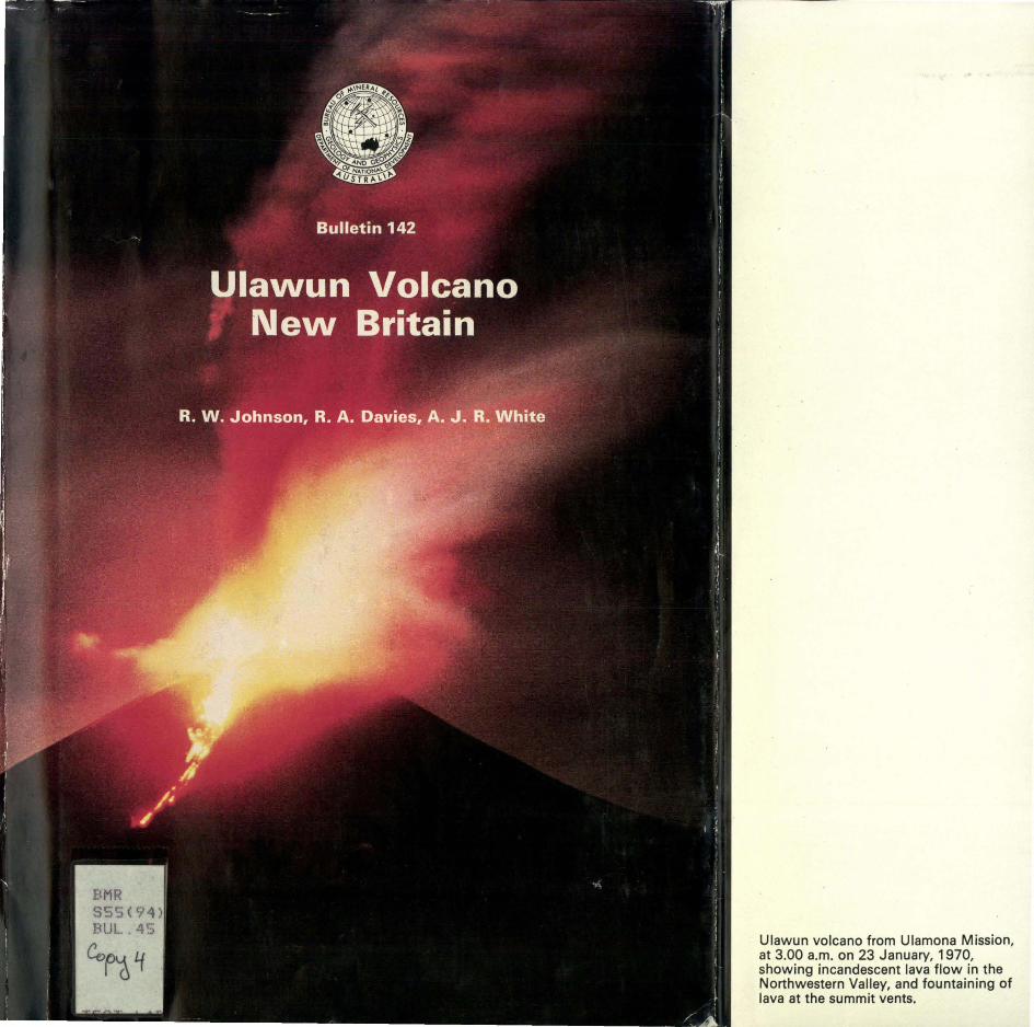
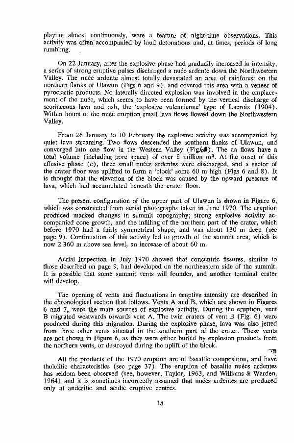
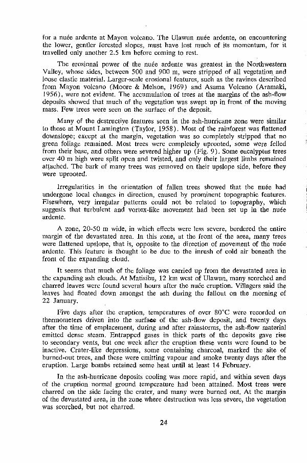
Ulawun volcano from Ulamona Mission, at 3.00 a.m. on 23 January, 1970, showing incandescent lava flow in the Northwestern Valley, and fountaining of lava at the summit vents.
DEPARTMENT OF NATIONAL DEVELOPMENT
BUREAU OF MINERAL RESOURCES, GEOLOGY AND GEOPHYSICS
BULLETIN 142
BULLETIN PNG 5
Ulawun Volcano, New Britain BY
R. W. JOHNSON AND R. A. DA VIES(R.o..\::x:Au.L. VoLC.W\.ol~Lccu.. . ObSv\J~~ , p~,-~-
(Bureau of Mmeral Resources) ~ ~~ Cko~L<l:u.
'S~) AND
A. J. R. WHITE (Australian National University)
Australian "Government Publishing Service
Canberra 1972
BUREAU OF MINERAL RESOURCES, GEOLOGY AND GEOPHYSICS
DIRECTOR: N. H. FISHER
GEOLOGICAL BRANCH
ASSISTANT DIRECTOR: J. N. CASEY
Published for the Minister for National Development,
The Han. R. W. C. Swartz, M.B.E., E.D., M.P.,
by the Australian Government Publishing Service
ISBN 0 642 00085 9
Printed by Graphic Services Pty Ltd, 60 Wyatt Street, Adelaide, S.A.
ERRATA SLIP FOR BULLE"TI~.rNo. 142 i" -,
(. ERRATA " ,
Contents List, P. iii, PETROLOGY - delete 'R.W. Johnston' and substitute 'R.Wo Johnson'.
Contents List, P. iv, ILLUSTRATIONS - Figure 11 -delete reference to page '28' and substitute page '27'.
In the first paper, the section heading 'INTRODUCTION' has inadvertently been given undue prominenceo
P. 13, paragraph 3, line 2, - delete 'Uuawun i and substitute 'Ulawun'.
P. 18, paragraph 3, line 3, - delete '(Fig. 9)' and substitute '(Fig. 6)'.
P. 20, paragraph 2, line 3, - delete '(Figs 1 and7) , and substitute '(Figs 6 and 7) '.
P. 24, paragraph 7, line 2, - delete 'surfaec' and substitute vsurface '.
P. 25, 26, - headings 'Seismic activity' and 'Ground tilt r should be in capitals.
P. 26, paragraph 7, line 1, - insert '3' at beginning of paragraph.
P. 28, delete paragraph numbers '3, 4, 6' and substitute numbers '4, 5, 6, 7' respectivelyo
P. 33, last paragraph, line 2, delete 'appear' and substitute 'appears '.
P. 40, paragraph entitled ACKNOWLEDGEMENTS, line 3, de lete '(Table 5)' and substitute '(Table 7)'.
P. 40, Heading to Table 7, - delete 'TABLES 4 AND 5' and substitute 'TABLES 5 AND 6'.
R.A. DaVies, co-author, is seconded to the Rabaul Volcanological Observatory of the Papua New Guinea Geological Survey.
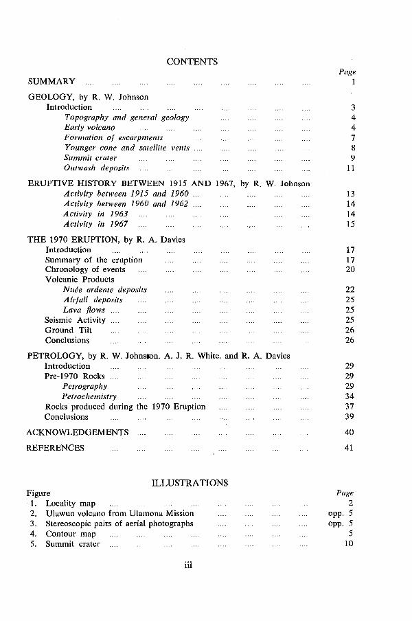
CONTENTS
SUMMARY Page
1
GEOLOGY, by R. W. Johnson Introduction 3
Topography and general geology 4 Early volcano 4 Formation 0/ escarpments 7 Younger cone and satellite vents 8 Summit crater 9 Olltwash deposits 11
ERUPTIVE HISTORY BETWEEN 1915 AND 1967, by R. W. Johnson Activity between 1915 and 1960 .... 13 Activity between 1960 and 1962 14 Activity in 1963 14 Activity in 1967 15
THE 1970 ERUPTION, by R. A. Davies Introduction 17 Summary of the eruption 17 Chronology of events 20 Volcanic Products
NlIee ardente deposits 22 Air/all deposits 25 Lava flows 25
Seismic Activity 25 Ground Tilt 26 Conclusions 26
PETROLOGY, by R. W. Johns~n. A. J. R. White. and R. A. Davies Introduction 29 Pre-1970 Rocks .... 29
Petrography 29 Petrochemistry 34
Rocks produced during the 1970 Eruption 37 Conclusions 39
ACKNOWLEDGEMENTS 40
REFERENCES 41
ILLUSTRATIONS Figure . 1. Locality map 2. Ulawun volcano from Ulamona Mission 3. Stereoscopic pairs of aerial photographs 4. Contour map 5. Summit crater
iii
Page 2
opp. 5 opp. 5
5 10
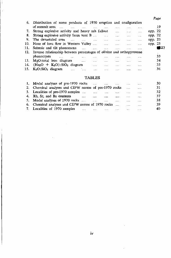
6. Distribution of some products of 1970 eruption and configuration of summit area
7. Strong explosive activity and heavy ash fallout 8. Strong explosive activity from vent B .... 9. The devastated area
10. Nose of lava flow in Western Valley .... 11. Seismic and tilt phenomena 12. Inverse relationship between percentages of olivine and orthopyroxene
phenocrysts 13. MgO:total iron diagram 14. (Na20 + ~O) :Si02 diagram 15. ~O:Si02 diagram
TABLES
1. Modal analyses of pre-1970 rocks 2. Chemical analyses and CIPW norms of pre-I970 rocks 3. Localities of pre-I970 samples 4. Rb, Sr, and Ba contents 5. Modal analyses of 1970 rocks 6. Chemical analyses and CIPW norms of 1970 rocks 7. Localities of 1970 samples
iv
Page
19 opp. 22 opp. 22 opp. 23 opp. 23
.a.7
33 34 35 36
30 31 32 37 38 39 40
SUMMARY
In January 1970, after a two-year period of inactivity, Ulawun volcano, on the north coast of New Britain, erupted. Ulawun is a stratovolcano built of basaltic and low-silica andesite lava flows and pyroclastic rocks, most of which were erupted from a central vent; many of the lavas were partly fragmented during flow, and some unsorted clastics mav have been deposited by nuees ardentes.
The symmetry of the volcano is broken by an east-west escarpment 160 m high that straddles its southern flank; it is probably the remains of a linear graben, or perhaps a caldera, formed by collapse of the summit. A younger cone rises from the base of the escarpment. In March 1969 a crater 130 m deep and 400 m wide lay at the summit of the younger cone, but this was buried during the eruption of January 1970.
Several mildly explosive eruptive events were observed between 1915 and 1967. They produced ash, lapilli, and bombs, but no lava flows or nuees ardentes. Those of April 1915 and January 1967 appear to have been the most violent; other notable periods of explosive activity were in 1960-62 and 1963.
The 1970 eruption is the most severe on record, and the first in which lava flows and nuees ardentes have been observed. Lava was jetted and fountained from the summit for four weeks, and during this period a nUl!e ardente devastated an area of rainforest on the northern slopes. At the onset of an effusive episode that produced more than 8 million cubic metres of lava, three small nuees ardentes were erupted, and a block 60 m high rose from the crater floor. Seismic activity and ground tilt varied with the intensity of the eruptive activity.
The rocks of Ulawun are highly porphyritic. The most common phenocryst is plagioclase; others are olivine (with rims of low-calcium pyroxene), augite, pleochroic orthopyroxene, iron-titanium oxides, and, more rarely, low-2V clinopyroxene. The groundmass includes all these minerals (except olivine) , and glass. The mineral assemblage is typical of tholeiitic basalts.
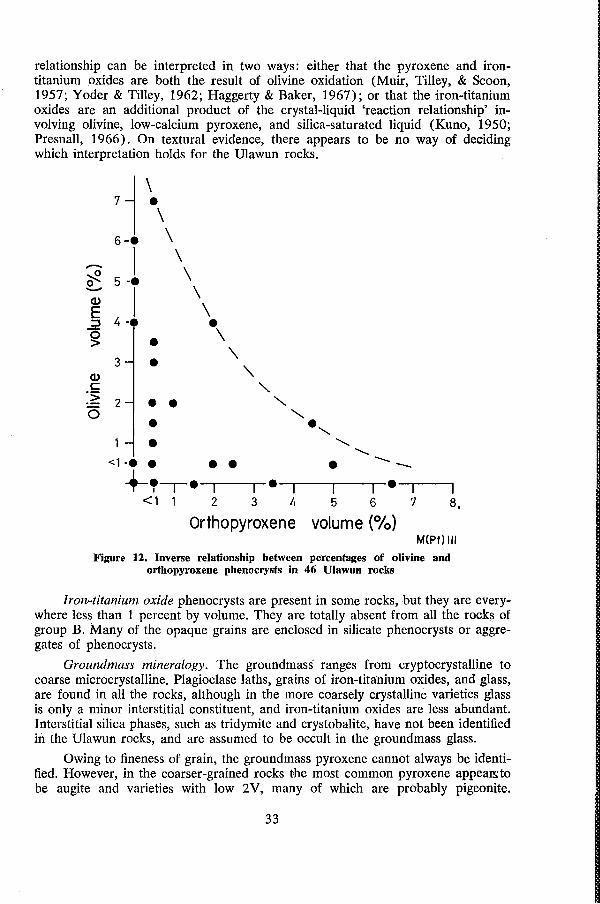
The chemical characteristics are also dominantly tholeiitic: the rocks are hypersthene normative and have a low ratio of total alkalis to silica. On the other hand, they are not strongly enriched in iron, and in this respect resemble a calcalkaline rather than a tholeiitic association. Ulawun lavas have a lower total-alkali content than those from Willaumez Peninsula, and the content can be correlated with depth to the seismic zone, which dips northward at about 70· beneath New Britain.
The products of the 1970 eruption are identical in composition with those of earlier eruptions, except that they are very slightly richer in TiC>:! and total Fe; but the variations are minimal.
1
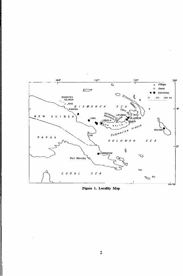
144· 14p· 152· ;56"
~ 0 Village
~ 0 Towns
G~ -- Volcanoes
SCHOUTEN 0 0 0 " 100 200 km
ISLANDS
,BAM
B SMA R C K ·MANAM n_ \'\. 0 --j 4·
• N E W G U N E A ~
LONG
~ - ()
" c~ M'~ "- t ran
~ or j n a Lee su b (!1
P A P U A "-
~ SOL 0 MON 5 E A
"- --\So ~
~
"'" COR A L SEA
~b
PIA 361
Figure 1. ~ality Map
2
GEOLOGY
by
R. W. Johnson
INTRODUCTION
Ulawun, also known as The Father, is one of several active volcanoes in Papua New Guinea. It rises as an imposing symmetrical cone from the north coast of New Britain island to a height of about 2 300 m, and with Bamus (South Son), another prominent stratovolcano to the southwest, occupies a commanding position in the chain of Quaternary volcanoes along New Britain's central north coast (Figs 1 and 2). These volcanoes are part of a much longer volcanic arc extending over 1 000 km from the Schouten Islands in the west to Rabaul in the east. The arc includes several volcanically active centres, such as Bam, Manam, and Long Islands and Langila, all of which have erupted during the last twenty years (Fig. 1).
Earthquake foci underlie Ulawun at depths of between 70 and 150 km, and define the shallow part of an inclined seismic zone which dips northwards at about 70° beneath New Britain (Denham, 1969 ; Johnson, Mackenzie, & Smith, 1971). South of New Britain, and parallel to the volcanic chain along the central north coast (excluding the volcanoes of Willaumez Peninsula; Fig. 1) is a submarine trench more than 8000 m deep.
Ulavyun has erupted several times this century. Up to 1967, the .eruptions were mildly explosive, and produced lapilli and ashes, most of which fell on the flanks of the volcano, and bombs which landed close to the summit crater. But in January 1970, the first observed major eruption took place: basaltic nuees ardentes and lava flows were produced, an area of rainforest on the northwestern flank of Ulawun was devastated, and the summit crater was severely modified. Many of the eruptions of Ulawun have been observed from Ulamona Roman Catholic Mission and Sawmill, 10 km northwest of the summit of the volcano. Ulawun is unpopulated, but there are villages within 16 km of the volcano to the southeast, and on the coast to the north and west.
Short geological accounts of Ulawun have been published by N. H. Fisher (1939, 1940, 1957) who, with C. E. Stehn, climbed the volcano in August 1937 (Fisher, 1937). The account presented in this paper is based on two periods of
3
field work, totalling thirteen days, in March and September 1969. A Bell 'Jet Ranger' helicopter was used to reach the summit crater, and to supply a base camp on the southwestern side of the volcano.
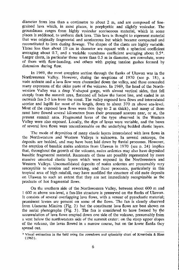
Topography and general geology At the 200 m contour level (Fig. 4), the area of Ulawun is about 200 km2; it is 18 km from northeast to southwest and 15 km from northwest to southeast. The outer slopes of the volcano increase uniformly from zero at sea-level to 37" just below the summit.
The southern slopes of Ulawun are straddled by a prominent north-facing east-west escarpment, about 160 m high, and about 1 715 m above sea-level at its highest point (Figs 2, 3, and 4). Tropical rainforest mantles the entire escarpment, including the steep northern face. Elsewhere on Ulawun, the forest canopy extends from sea-level to a sharply defined upper limit between 1 000 m and 1 450 m, above which the scoria and ash-covered slopes of the volcano are more or less clear of vegetation. There are two major stream valleys on the mountain, the Northwestern and Western Valleys, each of which cuts deep sections through the western flanks (Figs 2, 3, and 4).
Ulawun consists of thin lava flows and interbedded scoria and ash of basaltic and low-silica andesitic composition; dacitic and rhyolitic rocks have not been found on the volcano. The lavas are dark aphanitic rocks with phenocrysts of plagioclase and pyroxene; in some, olivine phenocrysts are also visible in hand specimen. The lava flows and pyroclastic material were erupted from a central vent whose position seems to have changed little throughout the history of the volcano. The prominent escarpment on the south flank of Ulawun suggests that there was large-scale collapse of the summit area, but later eruptions appear to have continued from a central vent, producing a younger cone whose products are assumed to be conformable with those of the older parts of the volcano on the western, northern, and eastern sides. Satellite cones and craters are present on the western and eastern flanks.
Early Volcano The older parts of Ulawun are best exposed in the Western and Northwestern Valleys and, to a lesser extent, in the wall of the east-west escarpment, and in a prominent south-facing cliff opposite the western' end of the escarpment (Figs 3 and 4).
From a distance, the wall of the east-west escarpment shows a crude terracing probably caused by thin lava flows (beneath soil cover) dipping to the south or southwest. Exposure is poor and, for the most part, inaccessible, but in places coarse clastic deposits with large boulders may be observed from the base of the escarpment; these fragmental deposits are probably intercalated with lava flows. A few dykes and sills are also exposed in both the east-west escarpment and the cliff opposite the western end of the escarpment.
Structures of the interiors of lava flows erupted during the earlier history of the volcano are exposed for about 3 km in the Western Valley between 675 m and 1 075 m above sea-level. Clastic textures, believed to have been caused by fragmentation of the lavas during flowage, are common. The clasts range in
4
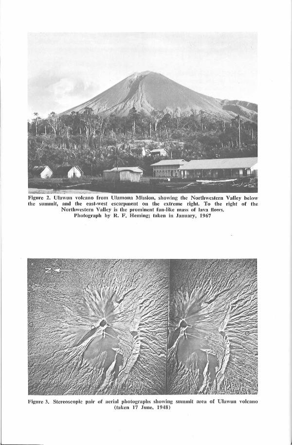
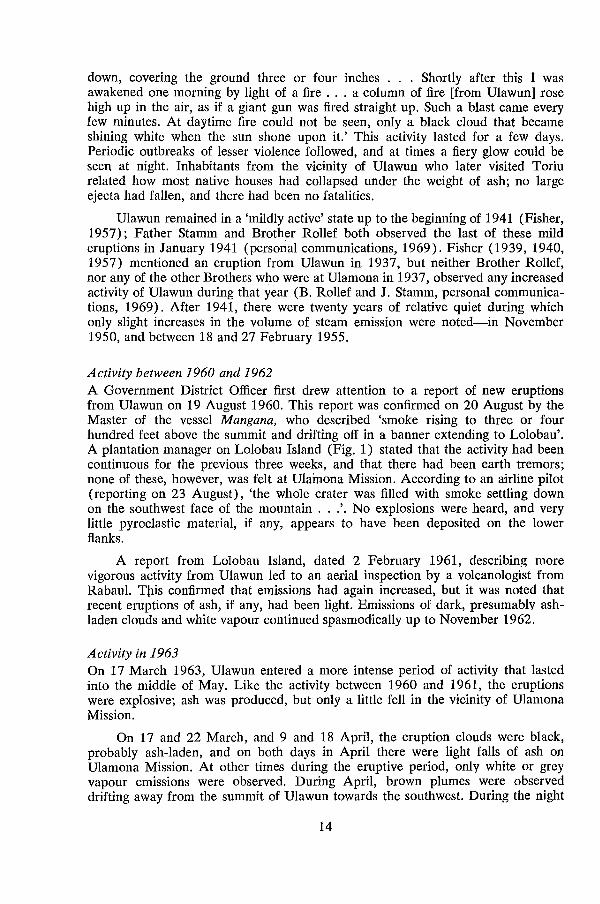
Figure 2. Ulawun volcano from Ulamona Mission, showing the Northwestern Valley below the summit, and the east-west escarpment on the extreme right. To the right of the
Northwestern Valley is the prominent fan-like mass of lava flows. Photograph by R. F . Heming; taken in January, 1967
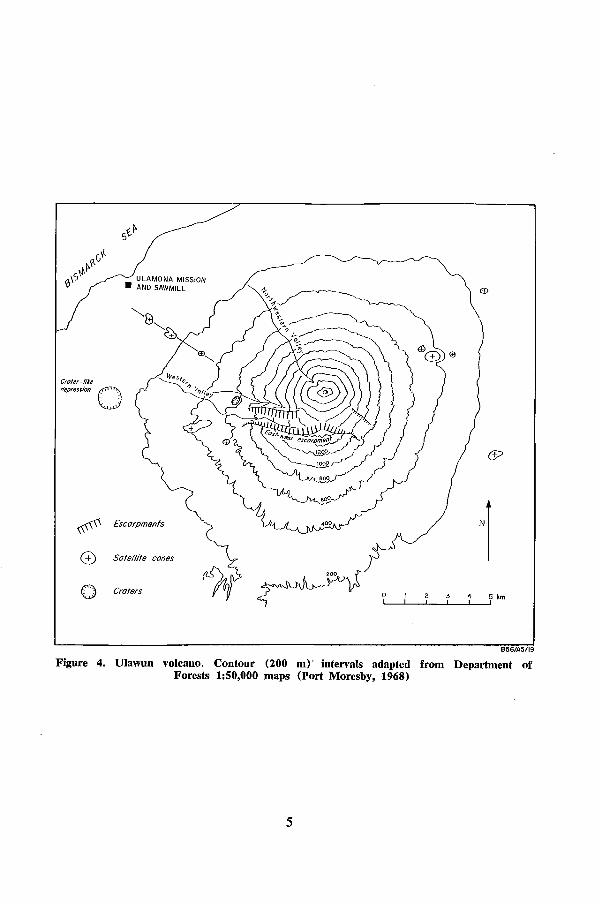
Figure 3. Stereoscopic pair of aerial photographs showing summit area of Ulawun volcano (taken 17 June. 1948)
~
ULAMONA MISSION • AND SAWMILL
6?
# Escarpments
'1 0 Sate/life canes
0 Craters 0 4 5 km I I I
B56/A5/19
Figure 4. Ulawun volcano. Contour (200 m)' intervals adapted from Department of Forests 1:50,000 maps (Port Moresby, 1968)
5
diameter from less than a centimetre to about 2 m, and are composed of finegrained lava which, in most places, is porphyritic and slightly vesicular. The groundmass ranges from highly vesicular scoriaceous material, which in some places is reddened, to uniform dark lava. This lava is thought to represent material that was originally fragmental and scoriaceous but which became compacted and reconstituted to lava during flowage. The shapes of the clasts are highly variable. Those less than about 10 cm in diameter are equant with a spherical coefficient averaging about 0.7, and a variable roundness coefficient averaging about 0.5*. Larger clasts, in particular those more than 0.5 m in diameter, are convolute, some of them with flow-banding, and others with gaping tension gashes formed by distension during flow.
In 1969, the most complete seCtion through the flanks of Ulawun was in the Northwestern Valley. However, during the eruptions of 1970 (see p. 18), a nuee ardente and a lava flow were channelled down the valley, and these concealed many exposures of the older parts of the volcano. In 1969, the head of the Northwestern Valley was a deep V-shaped gorge, with almost vertical sides, that fell steeply from the summit area, flattened off below the forest line, and ended in an outwash fan 2-3 km from the coast. The valley exposed lava flows and intercalated scoriae and lapilli for most of its length, down to about 370 m above sea-level. Most of the exposed lava flows were thin (up to 2 m thick), and many of them must have flowed several kilometres from their presumed sources near, or at, the present summit area. Fragmental lavas of the type observed in the Western Valley were also exposed. Locally, the dips of lavas were variable, and the bases of several lava flows were unconformable on the underlying bedded clastic layers.
The mode of deposition of many clastic layers intercalated with lava flows in the Northwestern and Western Valleys is unknown. In several outcrops, the deposits are bedded, and may have been laid down by fluvial processes. However, the eruption of basaltic nuees ardentes from Ulawun in 1970 (see p. 24) implies that, throughout the growth of the volcano, nuees ardentes may also have deposited basaltic fragmental material. Remnants of these are possibly represented by more massive unsorted clastic layers which were exposed in the Northwestern and Western Valleys. Unconsolidated deposits of nuees ardentes are presumably very susceptible to erosion and reworking, and these processes, particularly in this tropical area of high rainfall, may have modified the structure of old nuee deposits on Ulawun to such an extent that they are not immediately recognizable as the products of hot fragmental flows.
On the southern side of the Northwestern Valley, between about 600 m and 1 600 m above sea-level, a fan-like structure is preserved on the flanks of Ulawun. It consists of several overlapping lava flows, with a veneer of pyroclastic material; prominent levees are present on some of the flows. The fan is clearly observed from Ulamona Mission (Fig. 2) but the constituent lava flows are best shown on the aerial photographs (Fig. 3). The fan is considered to have formed by t}1e accumulation of lava flows erupted down one side of the volcano, presumably from a vent below the northwestern side of the summit crater: on the steep upper slopes of the volcano, the lavas flowed in a narrow course, but on the lower flanks they spread out.
* Visual estimation in the field using the roundness and sphericity chart of Krumbein & Sloss (1963) .
6
Formation of escarpments The symmetry of Ulawun is broken by a number of scarps and ridges, the most prominent of which is the east-west escarpment on the southern flank (Figs 2, 3, and 4). Fisher (1957) described this scarp as a 'remnant of an old caldera now almost completely filled by the present cone'. However, the escarpment does not appear to be part of a typical caldera ring fault, as it does not curve around the mountain; instead, it falls away to the east and west without significantly changing direction. There is no break in slope on the western, northern, or eastern sides of the volcano that might represent a mantled caldera rim; neither is a caldera ring fault exposed in the Northwestern Valley.
One explanation is that a caldera may have been present, but that it was drastically modified by large-scale erosion, and remnant features on the eastern, northern, and western sides of the volcano were completely concealed by later volcanic products. Concealment would also have been more complete if the northern part of the caldera rim had been lower than the rest of the escarpment. Hawaiian calderas, on the summits of low-angle shield volcanoes, have rims which vary little in altitude from one part of the escarpment to another; but in the case of a steep-sided cone such as Ulawun, slight eccentricity between the axis of the volcanic cone and the centre of the caldera produces marked differences in height along the rim. It is possible, therefore, that the centre of a caldera on Ulawun was slightly north of the volcano's central axis, and that erosion, and mantling of the northern par-t, left a high remnant ridge to the south.
Another interpretation is that the east-west escarpment represents the coalescent southern sides of two large radial erosion valleys. A remnant of the northern side of one of these valleys is possibly represented by the cliff opposite the western end of the east-west escarpment (Figs 3 and 4), and the other northern valley sides may be hidden beneath the younger cone. Erosion on a colossal scale was claimed to have scoured deep valleys on Reunion Island, Indian Ocean (Upton & Wadsworth, 1965), Manam volcano (Taylor, 1963) and Balbi volcano, Papua New Guinea (Blake & Miezitis, 1967). However, the rainfall catchment area for any such erosion valleys on Ulawun is only a few square kilometres, and although substantial erosion has clearly taken place, it is doubtful whether this small area could produce sufficient run-off to erode a topographic feature as large as the east-west escarpment.
Several calderas in the Basin and Range Province, Nevada, and the San Juan Mountains of New Mexico and Colorado, have central uplifted domes, termed 'resurgent domes' by Smith & Bailey (1962). These uplifted areas are straddled by linear fault grabens similar to the structures capping salt domes. It is possible that the escarpment on Ulawun could be the remnant southern fault scarp of a linear graben extending across the warped summit. area of the volcano. The northern part of the graben may be hidden beneath the younger cone, but parts of it may be represented by the south-facing cliff opposite the western end of the east-west escarpment and, possibly, also by the southwest-facing cliff southeast of the summit of Ulawun (Fig. 4).
Another interpretation for the origin of the cliff opposite the east-west escarpment is that it defines the southern scarp of a fault-bounded block, whose upper surface dips northwards, forming the southern side of the valley to the north (Figs 3 and 4). This interpretation is consistent with the view that a linear graben straddles the summit of Ulawun, as numerous linear faults, defining tilted blocks,
7
have also been described from resurgent domes in the Western United States (Smith & Bailey, 1969).
Thus, either collapse of a linear graben or cauldron subsidence seems the most likely explanation for the origin of the escarpment. If the escarpment was once part of a caldera, then erosion has severely modified it. It is unlikely that the escarpment was formed entirely by erosion.
Younger cone and satellite vents The following description of the younger part of Ulawun is based on observations made in 1969. Changes in the appearance of the cone after ,the 1970 eruptions are noted on page 18.
The vegetation-free slopes of the younger cone increase from about 25 0 at the forest line to 37" below the summit area. As shown by the contours in Figure 4, the younger 'cone' is not strictly conical: its flanks appear roughly planar, and they intersect in rounded spurs. In 1969, most parts of the flanks were mantled by thick deposits of unconsolidated fresh scoriae, lapilli, and ash, largely the products of explosive eruptions between 1960 and 1967. The northern slopes were covered with a continuous blanket of ash and lapilli, but on other slopes a hard crust of weathered volcanic debris was revealed beneath a thin veneer of unconsolidated deposits.
This hard crust appears to have been formed by exposure to the atmosphere. Rain and solar heat (and probably chemical weathering) combined to enhance disintegration of volcanic debris, which, when water-logged and exposed to the sun, is baked and hardened to a resistant layer. This layer, when dry, does not absorb rainwater easily, and during torrential downpours water flows rapidly over its surface. After longer periods of rain, however, the crust becomes saturated; it begins to erode, and the less consolidated underlying deposits are rapidly scoured.
Gullies on the southeastern slopes of the younger cone are filled with fresh black scoriae, extending in tongue-like masses from the rim of the summit crater to below 1450 m. These masses have well-defined flow fronts, and from the air they are indistinguishable from lava flows. As the scoria tongues do not appear on air-photographs taken in 1948 and 1965, it is concluded they probably formed during the eruptive activity of January 1967 (see page 15).
The scoria tongues almost certainly represent the deposits of fragmental avalanches or slides. The most likely interpretation is that hot scoriae landed on the steep upper slopes of the cone, and, cushioned and buoyed by heated air and volcanic gases, moved down-slope in lubricated avalanches. These were not nuees ardentes: the clastic components were almost exclusively scoriae, and they moved for only short distances down the steeper flanks, terminating on slopes greater than 20 0
, and forming prominent flow fronts. Similar avalanches of scoriae were observed during the 1970 Ulawun eruption (see page 20).
Compared to the mass of volcanic products erupted from the central vent, the volume emitted from satellite vents on Ulawun is insignificant, and is certainly less than 1 percent. The distribution of these satellite vents is shown in Figure 4; most are marked by steep-sided cones, and one appears to have a summit crater. South of Ulamona Mission, three prominent satellite cones form a chain which probably marks a flank fissure trending northwest, more or less radially to the
8
volcano. At the coast, west of the Mission, lava is exposed in a restricted area directly in line with the chain of satellite cones; this lava probably represents flows erupted from the flank fissure.
Summit Crater
In 1970, eruptions greatly modified the summit area of Ulawun: newly erupted material almost filled a deep, steep-walled crater which had been present, and new vents and other structural features were formed. In this section, the summit area of Ulawun is described as it appeared in March 1969. Changes brought about by the 1970 eruptions are described on page 18.
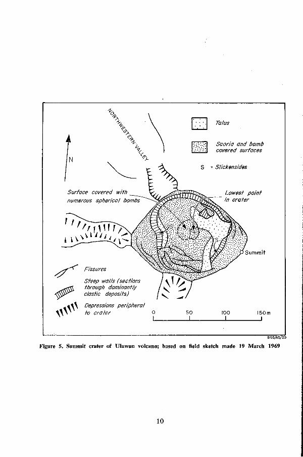
In 1969, the summit crater of Ulawun was about 400 m wide. In plan it had the approximate outline of a parallelogram with each straight side parallel to the contours of the contiguous flanks of the younger cone (Fig. 5). The highest parts of the rim were on the northern, eastern, and southeastern sides. The summit of Ulawun, on the eastern rim, was about 2 300 m above sea-level, and the deepest part of the crater, about 130 m below the summit, was slightly east of the centre of the depression. The two lowest points on the rim were at the head of the Northwestern Valley (2200 m), and on the southern rim (2250 m). At both of these saddles, and at the western comer of the crater, subsidiary depressions outside the crater rim suggested the presence of old satellite vents (Fig. 5).
Scoriae, bombs, lapilli, and ash constituted the bulk of exposures on the inner walls of the crater (Fig. 5). A few thin layers of lava (probably coalesced spatter) were also exposed in the western crater wall, and in the cliffs. of the depression at the head of the Northwestern Valley. Pyroclastic debris mantled most of the inner part of the crater, and talus was banked beneath the steeper walls. Scoriae and spindle, ribbon, and 'spherical' bombs (Macdonald, 1967) were all conspicuous on the rim of the crater. Spherical bombs were especially abundant on the crater floor, where they had probably accumulated by rolling from the higher parts of the crater walls (Fig. 5).
The crater rim on the western, southern, and eastern sides was cut by a series of en echelon concentric fissures (Fig. 5). These were subsidence structures formed by collapse of the inner crater walls towards the centre of the depression. At the crater rim, the fissures were dilatational, with small vertical displacements, but displacements were greater on fissures on the southwestern wall. About half way down the crater wall, some fractures showed no dilatation, and fault faces with vertical slickensides were exposed.
Fisher (1939) noted the concentric fractures on the summit crater rim in August 1937, and also observed a continuous steam cloud that rose from a vertical neck, 30-40 m in diameter, to which no bottom could be seen. Fisher (1957) later examined the air-photographs of Ulawun taken in 1948, which suggested to him that some reaming out of the crater and subsidence of the inner walls had taken
. place. J. G. Best, a former volcanologist at the Central Volcanological Observatory, Rabaul, made an aerial inspection of the summit of Ulawun on 7 October 1951. He noted that the vertical neck described by Fisher (1939) had been completely filled, and that there was no steam cloud (unpublished report, Central Volcanological Observatory) .
9
N
numerous spherical bombs
!
/ ~
"""
Fissures
Steep walls (sections throuqlJ dominantly clostic deposits)
Depressions peripheral to crater
\
o 1
D Talus
Scoria and bomb covered surfaces
= Slickensides
50 1
100 1
150m
B55/A5/29
Figure 5. Summit crater of Ulawun volcano; based on field sketch made 19 March 1969
10
In March 1969, the lowest point on the crater floor was covered with scoriae and talus blocks (up to 5 m across), and the vertical neck described by Fisher (1939) was not present. Fumarolic activity was restricted to drifting columns of water vapour, most of which emerged from the peripheral concentric fissures at the crater rim.
Outwash deposits It is probable that, throughout the growth of Ulawun, most of the ash and lapilli that fell on the volcano subsequently moved during periods of heavy rainfall. Outwash deposits, which cover various parts of Ulawun, consist of such derived pyroclastic material, with minor proportions of blocks derived from lava flows, washed down from the upper slopes of the volcano.
Thick accumulations of outwash debris are present at the head of the Western Valley, in the depression between the east-west escarpment and the southern slopes of the younger cone. Outwash material also forms prominent alluvial fans at the lower ends of the Northwestern and Western Valleys, and flat-lying beds near the coast.
11

ERUPTIVE HISTORY BETWEEN 1915 AND 1967
by
R. W. Johnson
Ulawun is in a conspicuous position on the north coast of New Britain. It is close to regular airline routes between Lae and Rabaul, and numerous island cargo boats ply the inshore waters of the Bismarck Sea, serving plantation and mission communities along the coastline. Few significant eruptions can therefore have gone unnoticed, and there is sufficient information to reconstruct a history of eruptive activity. The account that follows is based on data assembled in the files and Monthly Reports of the Central Volcanological Observatory, Rabaul, which, after the Second World War, undertook collation of data on volcanic eruptions in Papua New Guinea.
The data on eruptions from Ulawun are not comprehensive. Many of the records are incomplete. Furthermore, most of the observations were made from Ulamona Mission on the western side of the volcano (Fig. 4); and during the 'northwest' or wet season (December to March), when winds blow mainly eastwards, activity may not have been clearly visible from the Mission. The summit is also obscured for a large part of many days at other times of the year.
Most of the information on the eruptive history of Ulawun was cOl}-tfiqll~d by the late Father J. Stamm, a German missionary who first came to the U'ttft'Wtift area in 1914. From Ulamona and Toriu Missions, Father Stamm observed all the important eruptions of the volcano up to 1965. Father Stamm read and criticized an early draft of the account that follows; comments were also made by Brother B. Rollef, who has been at Ulamona Mission since 1937.
Activity between 1915 and 1960 In a letter dated 4 March 1961, Father Stamm recalled the first recorded eruption of Ulawun in 1915. The year before the outbreak, when Stamm arrived at Toriu Mission and Sawmill, northeast of the volcano (Fig. 1), he observed each day a plume of 'smoke' from Ulawun; when this emission ceased the local populace believed the volcano was moribund.
But in April 1915, an eruption suddenly began: 'At the beginning we could not see anything ... there was a heavy northwest storm, but we felt the ashes falling
13
down, covering the ground three or four inches . . . Shortly after this I was awakened one morning by light of a fire . '.' a column of fire [from Ulawun] rose high up in the air, as if a giant gun was fired straight up. Such a blast came every few minutes. At daytime fire could not be seen, only a black cloud that became shining white when the sun shone upon it.' This activity lasted for a few days. Periodic outbreaks of lesser violence followed, and at times a fiery glow could be seen at night. Inhabitants from the vicinity of Ulawun who later visited Toriu related how most native houses had collapsed under the weight of ash; no large ejecta had fallen, and there had been no fatalities.
Ulawun remained in a 'mildly active' state up to the beginning of 1941 (Fisher, 1957); Father Stamm and Brother Rollef both observed the last of these mild eruptions in January 1941 (personal communications, 1969). Fisher (1939, 1940, 1957) mentioned an eruption from Ulawun in 1937, but neither Brother Rollef, nor any of the other Brothers who were at Ulamona in 1937, observed any increased activity of Ulawun during that year (B. Rollef and J. Stamm, personal communications, 1969). After 1941, there were twenty years of relative quiet during which only slight increases in the volume of steam emission were noted-in November 1950, and between 18 and 27 February 1955.
Activity between 1960 and 1962 A Government District Officer first drew attention to a report of new eruptions from Ulawun on 19 August 1960. This report was confirmed on 20 August by the Master of the vessel Mangana, who described 'smoke rising to three or four hundred feet above the summit and drifting off in a banner extending to Lolobau'. A plantation manager on Lolobau Island (Fig. 1) stated that the activity had been continuous for the previous three weeks, and that there had been earth tremors; none of these, however, was felt at Ulainona Mission. According to an airline pilot (reporting on 23 August), 'the whole crater was filled with smoke settling down on the southwest face of the mountain .. .'. No explosions were heard, and very little pyroclastic material, if any, appears to have been deposited on the lower flanks.
A report from Lolobau Island, dated 2 February 1961, describing more vigorous activity from Ulawun led to an aerial inspection by a volcanologist from RabauI. Tpis confirmed that emissions had again increased, but it was noted that recent eruptions of ash, if any, had been light. Emissions of dark, presumably ashladen clouds and white vapour continued spasmodically up to November 1962.
Activity in 1963 On 17 March 1963, Ulawun entered a more intense period of activity that lasted into the middle of May. Like the activity between 1960 and 1961, the eruptions were explosive; ash was produced, but only a little fell in the vicinity of Ulamona Mission.
On 17 and 22 March, and 9 and 18 April, the eruption clouds were black, probably ash-laden, and on both days in April there were light falls of ash on Ulamona Mission. At other times during the eruptive period, only white or grey vapour emissions were observed. During April, brown plumes were observed drifting away from the summit of Ulawun towards the southwest. During the night
14
of 1/2 May, a glow from the crater projected a white circular area of light onto the base of a vapour cloud. Light blue-grey emissions of vapour were noted on 2 May and the days following; after 17 May only fluctuating vapour clouds were given off at varying intervals, and activity of this type lasted until October.
Activity in 1967
On 20 January 1967, it was reported that a 'steady glow' had been observed from Ulawun for five successive nights, and a further report on the 23rd stated that the volcano had erupted the previous night.
This eruption was short-lived. Brother F. Kleinelanghorst at Ulamona Mission recorded that the peak hours were between 2200 hours on the 22nd and 1000 hrs on the 23rd. During this period, ash fell on Ulamona to a depth of 10-12 mm, causing minor damage to native houses and crops in nearby gardens. There were reports that at the foot of Ulawun, 6-8 km east of Ulamona, the deposit was 5-8 cm thick, and that about 1.5 km up the mountain the layer was thicker, and the fragments were larger (up to 8 cm in diameter). Ash also fell in small quantities on Lolobau Island, causing slight damage to gardens, and collapse of structures (probably poorly constructed) at one of the plantations.
Many of the fresh volcanic bombs and scoria fragments which were observed by the writer on the summit area of Ulawun in 1969 were probably ejected during this eruption. A Government District Officer, for example, recorded 'reports of large rocks being blown high above the crater and then falling back inside'. Brother Rollef also described showers of incandescent bombs which rained down on the upper slopes of the cone, and one exceptionally large boulder which rolled down the northern flank at high speed, shedding a trail of glowing particles, and plunging into the forest (personal communication, 1969).
Throughout the remainder of 1967, a few reports were received of the periodic appearance of dark grey to black emissions above the crater. During June, for example, clouds were observed on several days, rising 30-100 m above the summit; this activity lasted only an hour or two. The last eruptions recorded in 1967 took place on 27 and 28 December, when similar dark grey clouds appeared.
The 1967 eruptions of Ulawun appear to have been the most spectacular of all the activity observed from Ulamona Mission up to that time. The red glow in the night sky, and the incandescent bombs ejected from the summit crater, appear to have impressed observers more than any earlier eruptive event from Ulawun. Father Stamm, who viewed the violent 1915 eruption of Ulawun, did not observe the 1967 eruption, and it is not possible, therefore, to compare the two events.
In summary, the observed eruptive events of Ulawun recorded between 1915 and 1967 were mildly explosive; those in April 1915 and January 1967 appear to have been the most violent. Eruptions produced pyroclastic material in sufficient quantities to cover various parts of the mountain slopes with thin veneers of ash
. and lapiIIi; no lava flows or nuees ardentes were erupted. Although data on most of the eruptions are incomplete, each period of activity appears to have had a similar life-history. The initial explosions seem to have been the most severe, and they were followed by periods of less violent eruptions, some of which lasted for several months after the initial outburst.
15

THE 1970 ERUPTION
by
R. A. Davies
INTRODUCTION
Ulawtnn has erupted five times during the last eleven years, and, therefore, with Bagana, Langila, and Manam volcanoes (Fig. 1) has been one of the most consistently active centres in Papua New Guinea in recent times. Ulawun is kept under surveillance by the staff of the Central Volcanological Observatory, Rabaul.
The first report confirming resurgence of activity at Ulawun reached the Central Observatory late on 14 January 1970. By early morning on 16 January an Observatory field station was operational at Ulamona Mission (10.5 km northwest of the summit of Ulawun), and visual and instrumental observations were made throughout most of the eruption. Weather conditions during daylight hours were variable, and at times the summit of Ulawun was obscured by cumulus cloud. However, during most nights until the end of January, clear weather prevailed, and observations were aided partly by strong moonlight.
There are no centres of population on the slopes of Ulawun, but over 700 people live along the north coast, within 16 km of the crater. Several of the villages were evacuated on 17 January, after an aerial inspection had shown that the activity was centred near the head of the prominent Northwestern Valley (see page 4). The 1958 eruption of Manam volcano (Taylor, 1963) had indicated the effectiveness of valleys in channelling nuees ardentes.
SUMMARY OF THE ERUPTION
The 1970 eruption can be divided broadly into: (a) a vapour emission phase, followed by (b) an explosive phase, which overlapped with (c) a quiet effusive phase. Phases (b) and (c) were followed by a decline in vapour emission, which represented a return to conditions of volcanic quiet.
One of the outstanding features of the eruption was the prolonged period of explosive activity, which had been established by 15 January, and which did not cease until 9 February. During this period, incandescent fountains and jets of lava,
17
playing almost continuously, were a feature of night-time observations. This activity was often accompanied by loud detonations and, at times, periods of long rumbling.
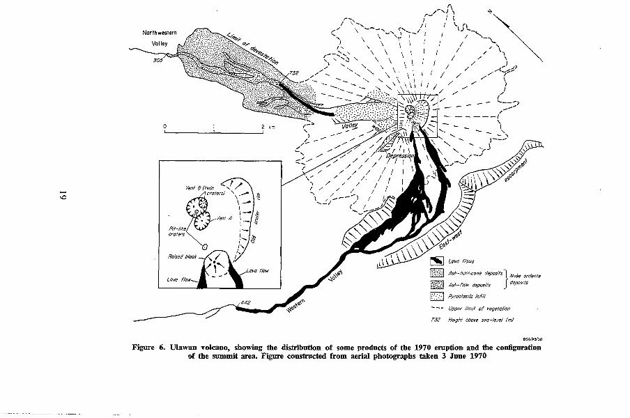
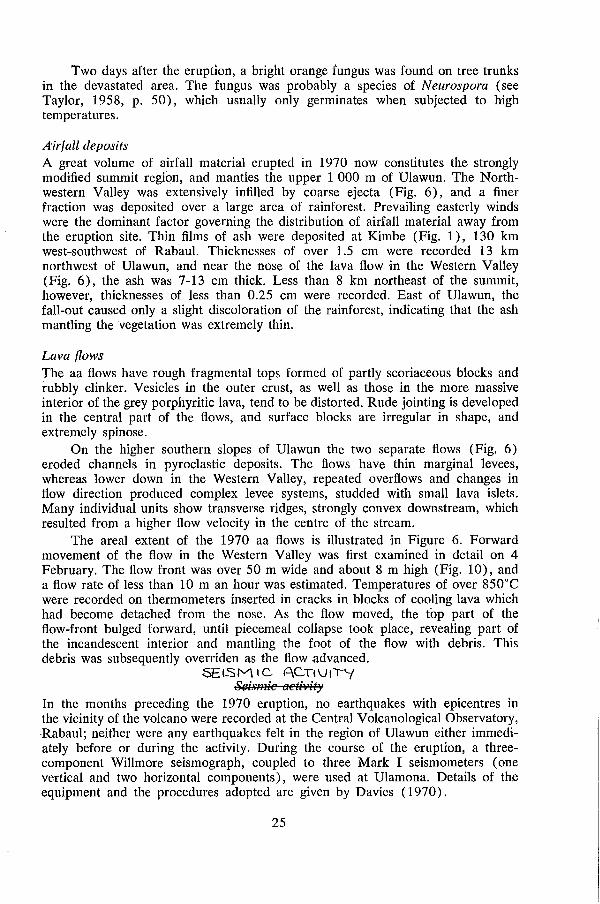
On 22 January, after the explosive phase had gradually increased in intensity, a series of strong eruptive pulses discharged a nuee ardente down the Northwestern Valley. The nuee ardente almost totally devastated an area of rainforest on the northern flanks of Ulawun (Figs 6 and 9), and covered this area with a veneer of pyroclastic products. No laterally directed explosion was involved in the emplacement of the nuee, which seems to have been formed by the vertical discharge of scoriaceous lava and ash, the 'explosive vulcanienne' type of Lacroix (1904). Within hours of the nuee erupti0D: small lava flows flowed down the Northwestern Valley.
From 26 January to 10 February the explosive activity was accompanied by quiet lava streaming. Two flows descended the southern flanks of Ulawun, and converged into one flow in the Western Valley (Fig.~I). The aa flows have a total volume (including pore space) of over 8 million m 3. At the onset of this effusive phase (c), three small nuees ardentes were discharged, and a sector of the crater floor was uplifted to form a 'block' some 60 m high (Figs 6 and 8). It is thought that the elevation of the block was caused by the upward pressure of lava, which had accumulated beneath the crater floor.
The present configuration of the upper part of Ulawun is shown in Figure 6, which was constructed from aerial photographs taken in June 1970. The eruption produced marked changes in summit topography; strong explosive activity accompanied cone growth, and the infilling of the northern part of the crater, which before 1970 had a fairly symmetrical shape, and was about 130 m deep (see page 9). Continuation of this activity led to growth of the summit area, which is now 2 360 m above sea level, an increase of about 60 m.
Aerial inspection in July 1970 showed that concentric fissures, similar to those described on page 9, had developed on the northeastern side of the summit. It is possible that some summit vents will founder, and another terminal crater will develop.
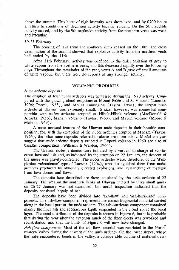
The opening of vents and fluctuations in eruptive intensity are described in the chronological section that follows. Vents A and B, which are shown in Figures 6 and 7, were the main sources of explosive activity. During the eruption, vent B migrated westwards towards vent A. The twin craters of vent B (Fig. 6) were produced during this migration. During the explosive phase, lava was also jetted from three other vents situated in the southern part of the crater. These vents are not shown in Figure 6, as they were either buried by explosion products from the northern vents, or destroyed during the uplift of the block.
!jI
All the products of the 1970 eruption are of basaltic composition, and hav~ tholeiitic characteristics (see page 37). The eruption of basaltic nuees ardentes has seldom been observed (see, however, Taylor, 1963, and Williams & Warden, 1964) and it is sometimes incorrectly assumed that nuees ardentes are produced only at andesitic and acidic eruptive centres.
18
...... 1.0
Northwestern
o
Lava
~:~::'.:::.: .. :::~:~ .... ~ .... ,;.. 0 .......
Od>""'o.s/"O'~o-?
2 km
r-, / " .... ,
//
" J
('-, '--- ..... ..... ( " ..... ~ .......
\ , \
\ ), "-
/' "- "- "-// "-
/-
/ /
'\ / /
I / / /
" / ---1 \ /.- / .... -1 (
.... ~
~ Ash-hurricane deposits} Nuee ordente
Ash- flow deposits deposits
D Pyroclasllc infill
Upper limit of veqefofion
132 Heigh! above sea-level (m)
B5~/A~~O
Figure 6. Ulawun volcano, showing the distribution of some products of the 1970 eruption and the configuration of the summit area. Figure constructed from aerial photographs taken 3 lune 1970
CHRONOLOGY OF EVENTS
9-14 January
Mission staff at Ulamona confirmed that activity began on 9 January with the emission of grey vapour from within the northern part of the crater. This continued until 14 January.
15-18 January
On the 15th, the main explosive phase (b) was clearly established, and aerial inspection on the 16th revealed explosive activity from three vents on the crater floor; two of these subsequently coalesced and formed vent A (Figs 6 and 7). The third vent was approximately in the position of the raised block shown in the inset on Figure 6. During the 17th and 18th, the eruption increased in intensity, and the growing cone of vent A could be seen clearly from Ulamona. With increasing ash content, the eruption column darkened. Loud detonations accompanied the eruption, which, during the night, showed as rhythmic jetting and fountaining of incandescent lava.
19-21 January
On the 19th, a new summit vent was opened (vent B in Fig. 6) and activity rapidly built up. During the day, a heavily charged eruption column could be seen rising over 5 000 m above sea level, and falls of fine ash were reported from areas southwest of Ulawun. Vents A and B (northern vents) played continuously, and at times were accompanied by weaker ejections from two other vents in the southern part of the crater. During the night, incandescent blocks were propelled
. as high as 450 m above the vents, and the continual impact of ejecta on the outer slopes of Ulawun imitated distant rifle-fire. Frequently, scoria, which had accumulated at the crater rim, would surge forward and then avalanche 400-800 m down into the Northwestern Valley, or down the northern flanks of Ulawun. Johnson (page 8) describes scoria tongues which may have formed in the same way during the 1967 eruption.
22 January
At 0405 hours a series of strong eruptive pulses discharged a nuee ardente down the Northwestern Valley. Emplacement of the nuee was preceded by accumulation of dense ash-laden vapour above the summit. Successive emissions appeared unable to rise through the eruption cloud; instead, they settled back, and finally enveloped the crater area. Incandescent scoriae mantled the cones of vents A and B. About 80 seconds later, abundant spots of light could be seen on the lower northwestern slopes, about 1 000 m above sea level; they probably marked the emergence of the basal component of the nuee ardente from the deep upper part of the Northwestern Valley. Incandescent blocks and ignited vegetation marked the path of the nuee through the rainforest, and above it an expanding ash-laden cloud billowed rapidly upwards. Between 0412 hours and 0420 hours, an electric storm, which generated a shower of light rain of about 10 minutes duration, raged within the cloud. At 0430 hours, as the ash cloud expanded and drifted westwards, a shower of accretionary lapilli fell on Ulamona Mission. The lapilli, 0.5-1.0 cm in diameter, were composed of damp, fine ash, and they easily disrupted on impact with the ground.
Aerial inspection later in the day revealed that a lava flow (probably initiated soon after the nuee ardente eruption) was descending the Northwestern Valley.
20
The flow was fed by two lava streams originating from the northern vents. The effusion of lava after nuee ardente eruptions was observed at Manam volcano (Taylor, 1963), Lopevi volcano (Williams & Warden, 1964), and Mayon volcano (Moore & Melson, 1969), and suggests that degassing of magma accompanies the production of nuees ardentes. During the night, strong explosive activity took place from four vents: vent A, vent B, and two vents in the southern part of the crater. At times, ejections from two or more vents were synchronous. More rhythmic jetting from the northern vents littered the slopes with incandescent bombs and scoria, which moved in spasms down the flanks of Ulawun. Surges of lava also issued from these vents at intervals; the colour of the glowing lava gave, by comparison with industrial smelting charts, an emission temperature of 1000-1100°C.
23-25 January The eruptive intensity was maintained during this period. Voluminous ash
laden vapour clouds, borne west-southwestwards, deposited fine ash up to 110m from Ulawun. .
26-27 January Clear weather at 2100 hours on the 26th revealed a marked change in
activity. Vent B alone was producing the typical rhythmic jetting, but a steady glow was noticeable over the southern vents, and to a lesser extent over the southern slopes of Ulawun. This glow indicated the pouring of lava, and, as it turned out, the beginning of the main effusive phase.
During the night the eruptive intensity fluctuated, and the expUlsion of three small nuees ardentes from the southern vents punctuated the effusive activity. During the eruption of all three nuees ardentes dense ash-laden vapour enveloped the summit, and the nuees masked the glow from the lava streams moving down the southern slopes. Short electric storms followed two of the eruptive events.
Aerial inspection on the 27th revealed that two lava flows were issuing from opposite sides of a prominent raised 'block' (Figs 6 and 8). This plock, over 60 m high, had probably been formed either before, or at the same time as, the onset of effusive activity. Its rugged, yet crumbling appearance (Fig. 8), arid the presence of· coarse subhorizontal banding, suggested that it was a raised section of the old crater floor, rather than a lava spine. The two lava flows had merged in the Western Valley (Fig. 8), and a flow rate of 20-25 metres an hour was estimated for the moving front.
28 January-l February Visual observation from Ulamona throughout this period was hampered by
extensive cloud cover. Strong explosive activity continued from vent B, and usually vent A. The close proximity of these two vents showed that vent B had migrated westwards. The rainforest on the southern and western flanks of Ulawun was, by this time, completely mantled with ash for distances up to 5 km from the summit.
2-9 February Brief periods of observations confirmed a decline in the eruptive intensity,
although a strong glow over the southern flanks of Ulawun during the night indicated that lava was still flowing. At 0340 hours on the 4th, the intensity of ejection from vent B increased dramatically, and lava jets rose more than 350 m
21
above the summit. This burst of high intensity was short-lived, and by 0700 hours a return to conditions of declining activity became evident. On the 5th, audible activity ceased, and by the 9th explosive activity from the northern vents was weak and irregular.
10-11 February The pouring of lava from the southern vents ceased on the 10th, and close
examination of the summit showed that explosive activity from the northern vents had ended by the 11 tho
After 11 th February, activity was confined to the quiet emission of grey to white vapour from the northern vents, and this decreased rapidly over the following days. Throughout the remainder of the year, vents A and B gave off small amounts of white vapour, but there were no reports of any stronger activity.
VOLCANIC PRODUCTS N uee ardente deposits The eruption of four nuees ardentes was witnessed during the 1970 activity. Compared with the glowing cloud eruptions at Mount Pelee and St Vincent (Lacroix, 1904; Perret, 1935), and Mount Lamington (Taylor, 1958), the largest nuee ardente at Ulawun was extremely small. Its size, however, was somewhat comparable with nuees ardentes erupted at Ribok-Ribok volcano (MacDonald & Alcaraz, 1956), Manam volcano (Taylor, 1963), and Mayon volcano (Moore & Melson, 1969).
A most unusual feature of the Ulawun nuee deposits is their basaltic composition, for, with the exception of the nuees ardentes erupted at Manam (Taylor, 1963), the other nuee deposits referred to above are more acidic. Modal analyses suggest that nuee ardente deposits erupted at Lopevi volcano in 1960 are also of basaltic composition (Williams & Warden, 1964).
The Ulawun nuees ardentes were initiated by a vertical discharge of scoriaceous lava and ash and, as indicated by the eruption on 22 January, the descent of the nuees was gravity-controlled. The nuees ardentes were, therefore, of the 'd'explosion vulcanienne' type of Lacroix (1904), who distinguished them from nuees ardentes produced by obliquely directed explosions, and avalanching of material from lava domes and flows.
The deposits here described are those emplaced by the nuee ardente of 22 January. The area on the southern flanks of Ulawun entered by three small nuees on 26-27 January was not examined, but aerial inspection indicated that the deposits consisted largely of ash.
The deposits have been divided into 'ash-flow' and 'ash-hurricane' components. The ash-flow component represents the coarse fragmental material carried along in the basal part of the nuee ardente. The ash-hurricane component contained mainly the finer ash and scoriaceous lapilli suspended in the cloud above the basal layer. The areal distribution of the deposits is shown in Figure 6, but it is probable that during the year after the eruption much of the finer ejecta was reworked and redistributed, and that the limits of Figure 6 will now have changed. Ash-flow component: Most of the ash-flow material was restricted to the Nort~ western Valley during the descent of the nuee ardente. On the lower slopes, where the nuee encountered bends in the valley, a considerable volume of material over-
22
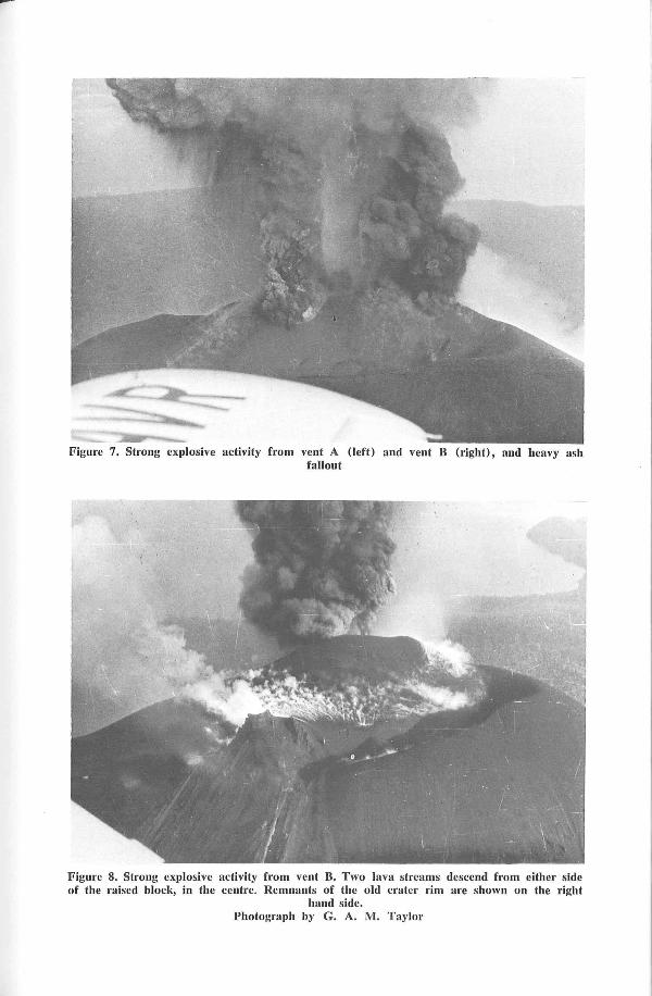
Figure 7. Strong explosive activity from vent A (left) and vent B (right), and heavy ash fallout
Figure 8. Strong explosive activity from vent B. Two lava streams descend from either side of the raised block, in the centre. Remnants of the old crater rim are shown on the right
hand side. Photograph by G. A. M. Taylor
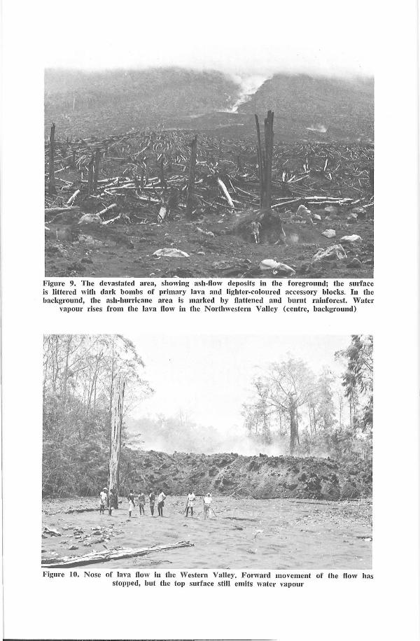
Figure 9. The devastated area, showing ash·flow deposits in the foreground; the surface is littered with dark bombs of primary lava and lighter-coloured accessory blocks. In the background, the ash-hurricane area is marked by flattened and bnrnt rainforest. Water
vapour rises from the lava flow in the Northwestern Valley (centre, background)
Figure 10. Nose of lava flow in the Western Valley. Forward movement of the How has stopped, but the top surface still emits water vapour
rode the steep banks, and spread northwards and northwestwards and produced tongues, as shown in Figure 6. Few good sections through the ash-flow deposits have been exposed by erosion, and their thickness is, therefore, not completely known. Near the terminal end of the ash-flow deposits, a thickness of more than 1 metre of ejecta was measured, whereas, 700 m above sea level, more than 5 metres were present in rain gullies eroded soon after the eruption. Aerial inspection suggested that, above 900 m in the Northwestern Valley, nuee deposits covered the valley floor, but that they did not increase in thickness towards the summit. It is probable that much of the coarse clastic material avalanched down as a result of the steep gradient, coming to rest on the lower slopes.
The ash-flow deposits consist of an unconsolidated mixture of poorly sorted ash, lapilli, bombs, and blocks. Over 80 percent of the material is porphyritic, 'primary' ejecta (new magma); of this, 60 percent is dark grey, and the remainder is oxidized to red or brown. The largest bombs are over 2 m in diameter (Fig. 9); over 100 bombs were counted with a diameter greater than 0.5 m. Many lapilli and bombs are subrounded, and most have pumiceous interiors and denser, scoriaceous margins. The interior of larger bombs is composed of partly vesicular basalt cut by scoriaceous fissures. Some bombs are fractur.¢d and broken, probably as the result of the continued release of volatiles after 'emplacement of the nuee ardentes. No iinpact craters were observed.
Scattered throughout the ash-flow (and ash-hurricane) deposits are accessory blocks and lapilli of light grey porphyritic basalt. These clasts differ from the primary ejecta in being more angular and rarely vesicular and lacking a scoriaceous crust. Locally, they litter the surface of the ash-flow deposits (Fig. 9). The largest block discovered was over 1.5 m across. Though it is possible that this accessory material was derived from the walls of the conduit, it seems more likely that it was picked up and transported by the nuee ardente from the higher parts of the Northwestern Valley.
The only evidence of sorting found in the nuee deposits is the presence of long narrow ridges, subparallel to the main river valleys. These ridges are composed of blocks with an average diameter of about 10 cm. They probably originated when the moving ash flow was deflected off a prominent shoulder or bank. During this change of course, larger particles, with a consequently greater inertia, were presumably less deflected, and therefore sorted into shoals on the valley sides.
A~h-hurricane component: The greater part of the devastated area was covered by a layer of black ash, with lapilli, bombs, and accessory blocks scattered throughout. The thickness of the ash layer ranges from less than 3 cm on elevated ridges and shoulders to over 1 m in river courses and topographic depressions. In many places, the ash was banked against the up-slope sides of bombs and blocks, which suggests that much of the finer component in the nuee arrived after the large ejecta were emplaced.
Effects and features of the nuee ardente: The descent of the nuee ardente on 22 January was controlled by gravity, and the steep slope of the upper part of Ulawun (up to 37"; see page 4) suggests that velocities were probably high. From the observations given on page 20, it seems that the nuee ardente travelled down the upper 1 300 m of the mountain at an average velocity of over 100 kph. Lacroix (1904) estimated velocities approaching 170 kph for glowing clouds at Mount Pelee, and Moore & Melson (1969) calculated a velocity range of 32-227 kph
23
for a nuee ardente at Mayon volcano. The Ulawun nuee ardente, on encountering the lower, gentler forested slopes, must have lost much of its momentum, for it travelled only another 2.5 km before coming to rest.
The erosional power of the nuee ardente was greatest in the Northwestern Valley, whose sides, between 500 and 900 m, were stripped of all vegetation, and loose clastic material. Larger-scale erosional features, such as the ravines described from Mayon volcano (Moore & Melson, 1969) and Asama Volcano (Aramaki; 1956), were not evident. The accumulation of trees at the margins of the ash-flow deposits showed that much of the vegetation was swept up in front of the moving mass. Few trees were seen on the surface of the deposit.
Many of the destructiye features seen in the ash-hurricane zone were similar to those at Mount Lamington (Taylor, 1958). Most of the rainforest was flattened downslope; except at the margin, vegetation was so completely stripped that no green foliage remained. Most trees were completely uprooted, some were felled from their base, and others were severed higher up (Fig. 9). Some eucalyptus trees over 40 m high were split open and twisted, and only their largest limbs remained attached. The bark of many trees was removed on their upslope side, before they were uprooted.
Irregularities in the orientation of fallen trees showed that the nuee had undergone local changes in direction, caused by prominent topographic features. Elsewhere, very irregular patterns could not be related to topography, which suggests that turbulent and vortex-like movement had been set up in the nuee ardente.
A zone, 20-50 m wide, in which effects were less severe, bordered the entire margin of the devastated area. In this zone, at the front of the area, many trees were flattened upslope, that is, opposite to the direction of movement of the nuee ardente, This feature is thought to be due to the inrush of cold air beneath the front of the expanding cloud.
It seems that much of the foliage was carried up from the devastated area in the expanding ash clouds. At Matisibu, 12 km west of Ulawun, many scorched and charred leaves were found several hours after the nuee eruption. Villagers said the leaves had floated down amongst the ash during the fallout on the morning of 22 January.
Five days after the eruption, temperatures of over 80°C were recorded on thermometers driven into the surface of the ash-flow deposit, and twenty days after the time of emplacement, during and after rainstorms, the ash-flow material emitted dense steam. Entrapped gases in thick parts of the deposits gave rise to secondary vents, but one week after the eruption these vents were found to be inactive. Crater-like depressions, some containing charcoal, marked the site of burned-out trees, and these were emitting vapour and smoke twenty days after the eruption, Large bombs retained some heat until at least 14 February.
In the ash-hurricane deposits cooling was more rapid, and within seven days of the eruption normal ground temperature had been attained. Most trees were charred on the side facing the crater, and many were burned out. At the margin of the devastated area, in the zone where destruction was less severe, the vegetation was scorched, but not charred,
24
Two days after the eruption, a bright orange fungus was found on tree trunks in the devastated area. The fungus was probably a species of Neurospora (see Taylor, 1958, p. 50), which usually only germinates when subjected to high temperatures.
A'irfall deposits A great volume of airfall material erupted in 1970 now constitutes the strongly modified summit region, and mantles the upper 1 000 m of Ulawun. The Northwestern Valley was extensively infilled by coarse ejecta (Fig. 6), and a finer fraction was deposited over a large area of rainforest. Prevailing easterly winds were the dominant factor governing the distribution of airfall material away from the eruption site. Thin films of ash were deposited at Kimbe (Fig. 1), 130 km west-southwest of Rabaul. Thicknesses of over 1.5 cm were recorded 13 km northwest of Ulawun, and near the nose of the lava flow in the Western Valley (Fig. 6), the ash was 7-13 cm thick. Less than 8 km northeast of the summit, however, thicknesses of less than 0.25 cm were recorded. East of Ulawun, the fall-out caused only a slight discoloration of the rainforest, indicating that the ash mantling the vegetation was extremely thin.
Lava flows The aa flows have rough fragmental tops formed of partly scoriaceous blocks and rubbly clinker. Vesicles in the outer crust, as well as those in the more massive interior of the grey porphyritic lava, tend to be distorted. Rude jointing is developed in the central part of the flows, and surface blocks are irregular in shape, and extremely spinose.
On the higher southern slopes of Ulawun the two separate flows (Fig. 6) eroded channels in pyroclastic deposits. The flows have thin marginal levees, whereas lower down in the Western Valley, repeated overflows and changes in flow direction produced complex levee systems, studded with small lava islets. Many individual units show transverse ridges, strongly convex downstream, which resulted from a higher flow velocity in the centre of the stream.
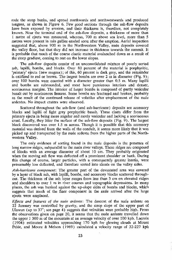
The areal extent of the 1970 aa flows is illustrated in Figure 6. Forward movement of the flow in the Western Valley was first examined in detail on 4 February. The flow front was over 50 m wide and about 8 m high (Fig. 10), and a flow rate of less than 10 m an hour was estimated. Temperatures of over 850°C were recorded on thermometers inserted in cracks in blocks of cooling lava which had become detached from the nose. As the flow moved, the top part of the flow-front bulged forward, until piecemeal collapse took place, revealing part of the incandescent interior and mantling the foot of the flow with debris. This debris was subsequently overriden as the flow .advanced.
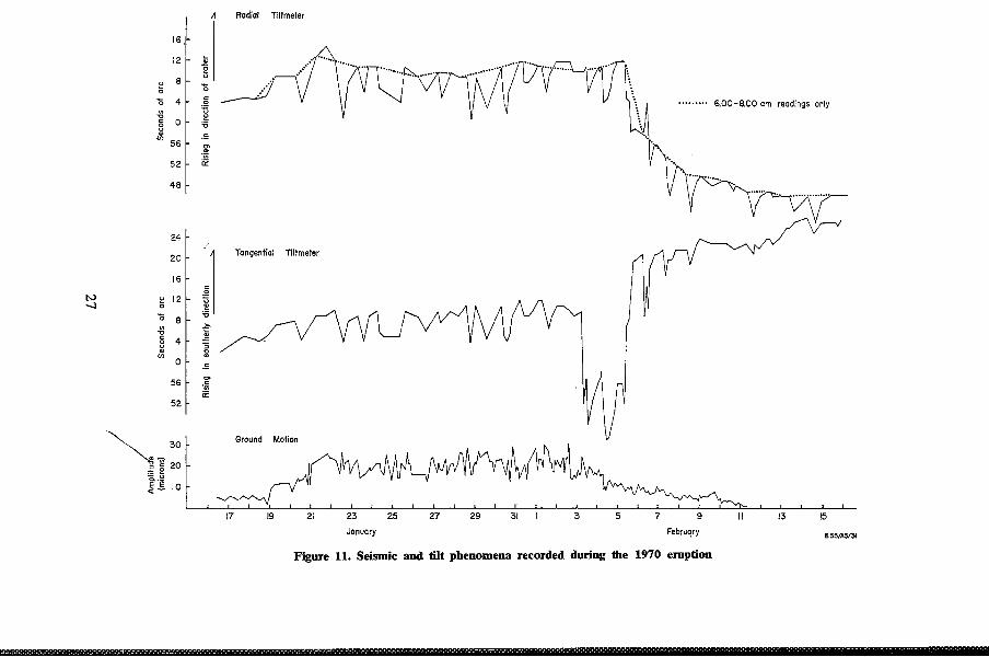
SEISM Ie. AC..TI\J(IY ~~ismie aC#'lity
In the months preceding the 1970 eruption, no earthquakes with epicentres in the vicinity of the volcano were recorded at the Central Volcanological Observatory, Rabaul; neither were any earthquakes felt in the region of Ulawun either immediately before or during the activity. During the course of the eruption, a threecomponent Willmore seismograph, coupled to three Mark I seismometers (one vertical and two horizontal components), were used at Ulamona. Details of the equipment and the procedures adopted are given by Davies (1970).
25
The seismic activity recorded was characterized by a continuous volcanic tremor, which probably originated in the vicinity of the crater. This type of volcanic earthquake is discussed by Minakami (1960). The period of the tremor ranged between 0.7 and 0.9 second on the vertical component, and between 0.7 and 1.0 second on the horizontal components. The variation in computed ground motion (double amplitude) is shown in Figure 11. It can be seen that the overall trend of the amplitude of ground motion is similar to that of the tilt variation graph for the radial component tiltmeter. More striking is the way this trend is in general accord with the pattern and intensity of the eruptive activity. This agreement is best shown by the events of 3-8 February, when waning activity was matched by declining ground motion. The general increase in ground motion after 16 January, reaching a peak of 25-28 microns immediately before the nuee ardente eruption on the 22nd, also agrees with the observed build-up in eruptive intensity.
GrQ.O Ll.f\.JJ> II L T CI'f)ttl'ld Tilt
Changes in inclination of the ground surface at Ulamona, recorded on two portable bubble tiltmeters (radial and tangential components), are shown in Figure 11. On most days three readings were taken, and it is apparent that a strong diurnal variation, independent of eruptive activity, is superimposed on the main trend. This trend is best shown by the plot of readings taken between 6 a.m. and 8 a.m. each morning (Fig. 11).
The data recorded on the radial tiltmeter (Fig. 11) indicate that tumescence of the volcano accompanied an early increase in volcanic activity; a maximum reading of nearly 15 seconds of arc took place before the nuee eruption of 22 January. The readings remained fairly steady until 5 February, when a rapid fall through 23 seconds of arc took place. Stability was regained about 11 February. This marked change in tilt is thought to indicate deflation of the volcanic pile, probably associated with the gradual withdrawal of magma from beneath, or within, the volcano. This conclusion is supported by the marked decrease in activity during this period.
The data recorded on the tangential tiltmeter are, in general, also sympathetic with changes in eruptive intensity. However, the marked change in tilt recorded on 3 and 4 February has no obvious explanation.
CONCLUSIONS
1. The 1970 activity was the most severe eruption observed at Ulawun, and the first occasion on which the expUlsion of nuees ardentes and lava flows had been seen at the volcano.
2. All the 1970 products are of basaltic composition, and have tholeiitic affinities (see page 37). The eruption of basaltic nuees ardents is an event which has seldom been observed outside Papua New Guinea.
3.The nuees ardentes were of the 'explosion vulcanienne' type. The nuee eruption on 22 January devastated an area of rainforest on the northern slopes of Ulawun: most trees were flattened downslope, stripped of all foliage, and sev~rely charred. The surface of the devastated area was covered with tongues of coarse clastic ejecta, surrounded by a thin veneer of dominantly fine ash. An av4rage velocity of over 100 km an hour was calculated for the descent of the nuee ardente down the upper part of the Northwestern Valley.
26
16~ i1
Radial Tiltmeter
12
8 ~ '0 0
'0 4 " 0 ~ •.••.••.. 6.00-8.00 am readings only
"0 ~ 8 0 '5
Jl 56 " ~
·in
52 iE
48
24 I
20
t1
Tangential Tiltmeter
16
IV ~ 12 -...l 0
'0 8 "0
0 ~ ~
~ 4 =s
V) g a
" 56 '" " ·in
iE 52
31
January Februgry B55/A5I~
Figure 11. Seismic and: tilt phenomena recorded during the 1970 eruption
4-.1. Soon after the nuee ardente was discharged on 22 January, lava was expelled; this suggest that degassing of the magma accom t'anied the nuee eruption.
5.1. The main effusive phase began with the rise of a block 60 m high from the disrupted crater floor, and the eruption of three small nuees ardentes. The total volume of lava expelled exceeded 8 x 10 6 rna.
b.The eruption produced marked changes in summit topography. Most of the crater and the upper part of the Northwestern Valley was infilled by the products of strong explosive activity. The terminal cones of vents A and B, and the raised block, now dominate the summit of Ulawun, which has grown about 60 m.
I. I. The level of seismic activity and tilting of the ground both varied with eruptive intensity.
28
PETROLOGY
by
R. W. Johnson, A. J. R. White!, and R. A. Davies
INTRODUCTION
Seventy-seven Ulawun rocks have been examined in thin section, and 24 samples, believed to be representative of rocks from all exposed parts of the volcano, have been chemically analysed. It is necessary to emphasize, however, that the core of Ulawun is concealed, that the oldest rocks exposed probably belong to only the younger carapace of the volcano, and, therefore, that the samples we have examined may not be representative of the entire volcano.
PRE-1970 ROCKS Petrography Fifty-eight samples of Ulawun rocks extruded before 1970 have been examined in thin section. Modal and chemical analyses of 14 of these are given in Tables 1 and 2 respectively, and sample localities are briefly described in Table 3. Four groups, A, B, C, and D, corresponding to different sampling areas on the volcano, are also distinguished in Table 3. The relative ages of the four groups are unknown, except that group C is undoubtedly the youngest, and groups A and B are probably the oldest.
The rocks of Ulawun are highly porphyritic; most contain between 10 and 40 percent phenocrysts (by volume). The phenocrysts are plagioclase, magnesian olivine, clinopyroxene (mainly augite), pleochroic orthopyroxene, and iron-titanium oxides. No amphibole phenocrysts have been found.
Plagioclase is the most abundant phenocryst mineral and, in most samples, it makes up between 10 and 35 percent of the rock. The phenocrysts show a wide range of size and habit. Many large crystals, up to 4 mm long, contain abundant inclusions of groundmass material; smaller phenocrysts tend to be free of inclusions.
1 Australian National University, Canberra; present address: La Trobe University, Melbourne.
29
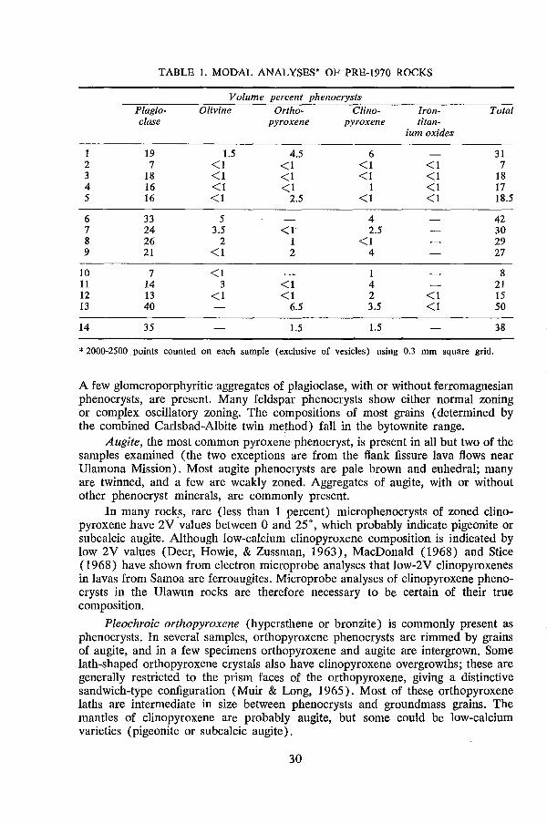
TABLE 1. MODAL ANALYSES> OF PRE-1970 ROCKS
Volume percent phenocrysts Plagio- Olivine Ortho- Clino- [ran- Total clase pyroxene pyroxene titan-
ium oxides
1 19 1.5 4.5 6 31 . 2 7 <1 <1 <1 <1 7 3 18 <1 <1 <1 <1 18 4 16 <1 <1 1 <1 17 5 16 <1 2.5 <1 <1 18.5
6 33 5 4 42 7 24 3.5 <1 2.5 30 8 26 2 1 <1 29 9 21 <1 2 4 27
10 7 <1 1 8 11 14 3 <1 4 21 12 13 <1 <1 2 <1 15 13 40 6.5 3.5 <1 50
14 35 1.5 1.5 38
* 2000-2500 points counted on each sample (exclusive of vesicles) using 0.3 mm square grid.
A few glomeroporphyriticaggregates of plagioclase, with or without ferromagnesian phenocrysts, are present. Many feldspar phenocrysts show either normal zoning or complex oscillatory zoning. The compositions of most grains (determined by the combined Carlsbad-Albite twin method) fall in the bytownite range.
Augite, the most common pyroxene phenocryst, is present in all but two of the samples examined (the two exceptions are from the flank fissure lava flows near Ulamona Mission). Most augite phenocrysts are pale brown and euhedral; many are twinned, and a few are weakly zoned. Aggregates of augite, with or without other phenocryst minerals, are commonly present.
In many rock_s, rare (less than 1 percent) microphenocrysts of zoned clinopyroxene have 2V values between 0 and 25°, which probably indicate pigeonite or subcalcic augite. Although low-calcium clinopyroxene composition is indicated by low 2V values (Deer, Howie, & Zussman, 1963), MacDonald (1968) and Stice (1968) have shown from electron microprobe analyses that low-2V clinopyroxenes in lavas from Samoa are ferroaugites. Microprobe analyses of clinopyroxene phenocrysts in the Ulawun rocks are therefore necessary to be certain of their true composition.
Pleochroic orthopyroxene (hypersthene or bronzite) is commonly present as phenocrysts. In several samples, orthopyroxene phenocrysts are rimmed by grains of augite, and in a few specimens orthopyroxene and augite are intergrown. Some lath-shaped orthopyroxene crystals also have clinopyroxene overgrowths; these are generally restricted to the prism faces of the orthopyroxene, giving a distinctive sandwich-type configuration (Muir & Long, 1965). Most of these orthopyroxene laths are intermediate in size between phenocrysts and groundmass grains. The mantles of clinopyroxene are probably augite, but some could be low-calcium varieties (pigeonite or subcalcic augite).
30
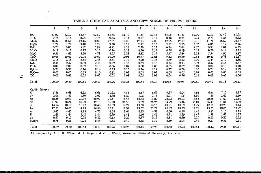
TABLE 2. CHEMICAL ANALYSES AND CIPW NORMS OF PRE-1970 ROCKS
1 2 3 4 5 6 7 8 9 10 11 12 13 14
SiO, 51.92 52.32 52.47 52.50 55.48 51.79 51.84 52.43 54.95 51.31 52.10 52.33 53.47 51.98 TiO, 0.78 0.76 0.75 0.76 0.52 0.74 0.77 0.77 0.48 0.94 0.75 0.73 0.86 0.72 Al,O, 16.37 18.66 19.16 18.80 17.85 18.06 17.13 17.80 17.05 17.17 16.78 17.71 16.67 20.37 Fe"O, 3.77 3.22 3.40 3.29 3.30 2.51 2.92 3.32 3.17 3.16 3.07 4.05 2.17 2.16 FeO 6.70 6.05 5.82 5.92 4.75 7.25 7.50 6.55 6.34 7.02 7.32 6.33 8.04 6.23 MnO 0.19 0.17 0.17 0.16 0.14 0.17 0.20 0.18 0.18 0.19 0.19 0.20 0.19 0.15 MgO 6.56 4.69 4.90 4.79 4.75 5.85 6.32 5.17 5.47 5.64 6.52 5.54 4.90 3.87 CaO 10.66 10.60 10.76 10.67 10.00 10.98 10.77 10.61 9.82 10.70 10.84 1D.43 9.78 11.17 Na,O 2.16 2.48 2.48 2.48 2.53 2.19 2.20 2.35 2.39 2.32 2.19 2.44 2.49 2.56 K"O 0.34 0.32 0.32 0.35 0.39 0.32 0.33 0.36 0.34 0.33 0.32 0.32 0.44 0.37 p,O. 0.08 0.08 0.09 0.10 0.06 0.09 0.08 0.08 0.05 0.09 0.09 0.07 0.10 0.10 H,O+ 0.73 0.33 0.14 0.18 0.35 0.16 0.26 0.19 0.22 0.26 0.20 0.22 0.19 0.29 H,O- 0.03 0.07 0.03 0.10 0.11 0.07 0.08 0.07 0.08 0.05 0.03 0.05 0.06 0.08
w ..... CO, 0.00 0.05 0.05 0.07 0.03 0.08 0.05 0.05 0.04 0.76 0.11 0.00 0.02 0.06
Total 100.29 99.80 100.54 100.17 100.26 100.25 100.45 99.93 100.58 99.94 100.51 100.42 99.38 100.11
CIPW Norms Q 5.86 6.68 6.32 6.66 11.32 4.54 4.47 6.69 9.77 6.04 4.94 6.31 7.12 4.87 or 2.01 1.89 1:89 2.07 2.30 1.89 1.95 2.13 2.01 1.95 1.89 1.89 2.60 2.19 ab 18.28 20.99 20.99 20.99 21.41 18.53 18.62 19.89 20.22 19.63 18.53 20.65 21.07 21.66 an 33.97 38.84 40.20 39.13 36.20 38.50 35.89 36.96 ·34.79 35.46 35.01 36.43 33.01 43.00 di 14.94 10.57 10.02 10.40 10.39 12.22 13.68 12.15 10.91 10.02 14.29 12.09 12.23 9.44 hy 17.35 14.03 14.29 14.06 12.21 18.92 19.52 15.29 16.87 18.23 19.29 15.37 18.05 13.72 mt 5.47 4.67 4.93 4.77 4.78 3.64 4.23 4.81 4.60 4.58 4.45 5.87 3.15 3.13 il 1.48 1.44 1.42 1.44 0.99 1.41 1.46 1.46 0.91 1.79 1.42 1.39 1.63 1.37 ap 0.17 0.17 0.20 0.22 0.13 0.20 0.17 0.17 0.11 0.20 0.20 0.15 0.22 0.22 others 0.76 0.51 0.28 0.44 0.53 0.40 0.45 0.37 0.39 2.04 0.48 0.27 0.30 0.51
Total 100.29 99.80 100.54 100.17 100.26 100.25 100.45 99.93 100.58 99.94 100.51 100.42 99.38 100.11
All analyses by A. J. R. White, M. J. Kaye, and Z. L. Wasik, Australian National University, Canberra.
Sample number
l. 2.
3.
4.
5.
6.
7.
8.
9.
10.
11.
12.
13.
14.
TABLE 3. LOCALITY INDEX FOR SAMPLES OF TABLES 1 AND 2
BMR sample number
51NG0077 51NG0065B
51NG0079
51NG0066
51NG0094
51NG0098
51NG0158
51NG0156
51NG0150
51NG0059
51NG0089
51NG0091
51NG0095
51NG0822
Locality description
Group A. Western Valley Boulder in stream bed; main stream section Centre of 30 cm-thick steeply dipping lava flow; 920 m above sea-level in main stream section Centre of lava flow (possibily a sill) at least 4 m thick; 810 m above sea-level in main stream section Lava flow; 970 m above sea-level in main stream section Lava flow; 910 m above sea-level in cliff north of main stream section
Group B. Northwestern Valley
Lava flow of unknown thickness; 570 m above sea-level Lava flow, 25 cm thick, in gully on north side of main stream; 980 m above sea-level Lava flow of unknown thickness; 710 m above sea-level Top of lava flow; 360 m above sea-level
Group C. Younger Cone
Core of bomb on western rim of summit crater; 2 130 m above sea-level Bomb on southwestern slopes; 1 930 m above sealevel Base of 8 m-thick lava flow on southwestern slopes; 1 840 m above sea-level Bomb on western slopes; 1 350 m above sea-level
Group D. Flank fissure lava flow
Outcrop 1 km southwest of Ulamona Mission
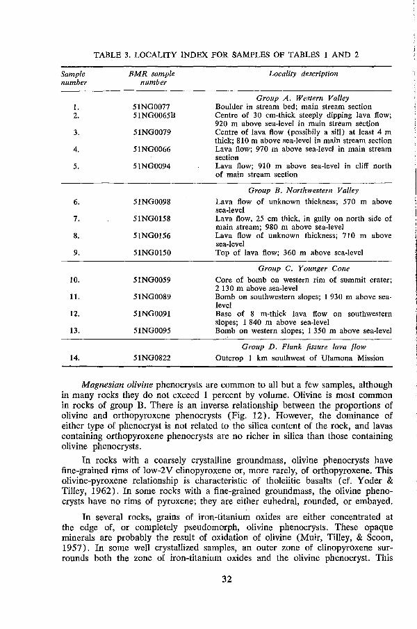
Magnesian olivine phenocrysts are common to all but a few samples, although in many rocks they do not exceed 1 percent by volume. Olivine is most common in rocks of group B. There is an inverse relationship between the proportions of olivine and orthopyroxene phenocrysts (Fig. 12). However, the dominance of either type of phenocryst is not related to the silica content of the rock, and lavas containing orthopyroxene phenocrysts are no richer in silica than those containing olivine phenocrysts.
In rocks with a coarsely crystalline groundmass, olivine phenocrysts have fine-grained rims of low-2V clinopyroxene or, more rarely, of orthopyroxene. This olivine-pyroxene relationship is characteristic of tholeiitic basalts ( cf. Yoder & Tilley, 1962). In some rocks with a fine-grained groundmass, the olivine phenocrysts have no rims of pyroxene; they are either euhedral, rounded, or embayed.
In several rocks, grains of iron-titanium oxides are either concentrated at the edge of, or completely pseudomorph, olivine phenocrysts. These opaque minerals are probably the result of oxidation of olivine (Muir, Tilley, & Scaon, 1957). In some well crystallized samples, an outer zone of clinopyroxene surrounds both the zone of iron-titanium oxides and the olivine phenocryst. This
32
relationship can be interpreted in two ways: either that the pyroxene and irontitanium oxides are both the result of olivine oxidation (Muir, Tilley, & Seoon, 1957; Yoder & Tilley, 1962; Haggerty & Baker, 1967); or that the iron-titanium oxides are an additional product of the crystal-liquid 'reaction relationship' involving olivine, low-calcium pyroxene, and silica-saturated liquid (Kuno, 1950; Presnall, 1966). On textural evidence, there appears to be no way of deciding which interpretation holds for the Ulawun rocks.
7l \ • \
\ 6-.
I \ ....-\ ~
° 5 -. \ - I (J)
E \ ::::J 4·. • <5 • \ >
3 • \ (J) \ c "-:~ 2 • • "-0 " • .,
• "- ......... <1-•• • • • -- -+-'-'-. I • I • I I
<1 1 2 3 4 5 6 7 8,
Orthopyroxene volume (%) M(Pt)III
Figure 12. Inverse relationship between percentages of olivine and orthopyroxene phenocrysts in 46 Ulawun rocks
Iron-titanium oxide phenocrysts are present in some rocks, but they are everywhere less than 1 percent by volume. They are totally absent from all the rock~ of group B. Many of the opaque grains are enclosed in silicate phenocrysts or aggregates of phenocrysts.
Groundmass mineralogy. The groundmass ranges from cryptocrystalline to coarse microcrystalline. Plagioclase laths, grains of iron-titanium oxides, and glass, are found in all the rocks, although in the more coarsely crystalline varieties glass is only a minor interstitial constituent, and iron-titanium oxides are less abundant. Interstitial silica phases, such as tridymite and crystobalite, have not been identified in the Ulawun rocks, and are assumed to be occult in the groundmass glass.
Owing to fineness of grain, the groundmass pyroxene cannot always be identified. However, in the coarser-grained rocks the most common pyroxene appeal5to be augite and varieties with low 2V, many of which are probably pigeonite.
33
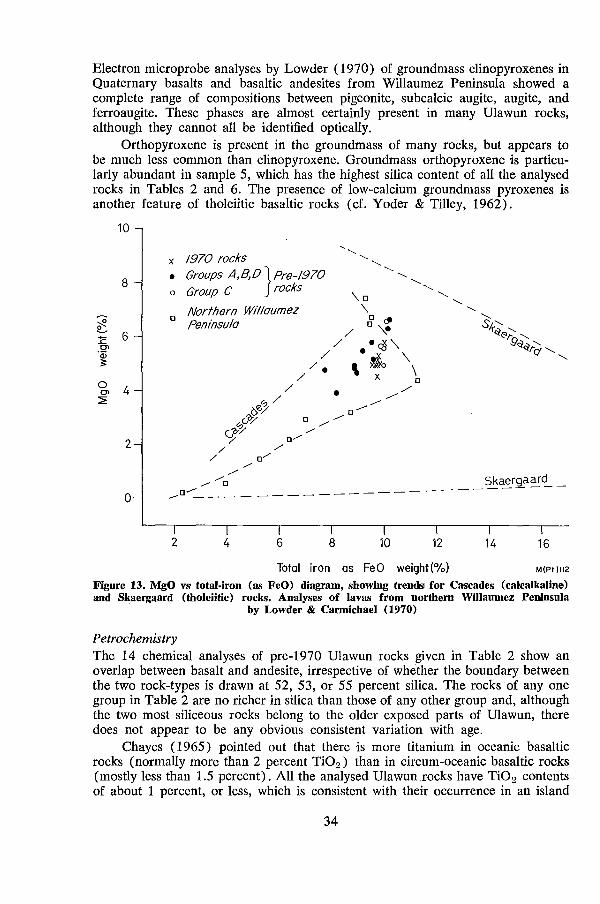
Electron microprobe analyses by Lowder (1970) of groundmass clinopyroxenes in Quaternary basalts and basaltic andesites from Willaumez Peninsula showed a complete range of compositions between pigeonite, subcalcic augite, augite, and ferroaugite. These phases are almost certainly present in many Ulawun rocks, although they cannot all be identified optically.
Orthopyroxene is present in the groundmass of many rocks, but appears to be much less common than clinopyroxene. Groundmass orthopyroxene is particularly abundant in sample 5, which has the highest silica content of all the analysed rocks in Tables 2 and 6. The presence of low-calcium groundmass pyroxenes is another feature of tholeiitic basaltic rocks (cf. Yoder & Tilley, 1962).
10
8
~ L :E 6 .2'
<1> ;:
0 0> 4 :2
2
o
x 1970 rocks • Groups A,B,D }pre-1970 o Group C rocks
o Norfhern Willaumez Peninsula
, ,
\0 \
'-. '-.
o / o,,~
'-.
/ • ...x' ./ .'-0'
'-. '-.
//. \ !to \ / x \
?§,r;,/ • //0
c-'&/ --- ........ G?r~ 0 / / 0
// all
/ /' 0/ /
'-. '-. ,
'-.
S' f~(;>;;- '-., 9~~r(j '-. '-.
/ /
/ 0 ...... 0 ........ ___________________ 5k~r~~~ -
2 4 6 8 10 12 14 16
Total iron as FeO weight(%) M(PI)112
Figure 13. MgO vs total·iron (as FeO) diagram, showing trends for Cascades (cakalkaIine) and Skaergaard (tholeiitic) rocks. Analyses of lavas from northern Willaumez Peninsula
. by Lowder & Carmichael (1970) .
Petrochemistry The 14 chemical analyses of pre-I970 Ulawun rocks given in Table 2 show an overlap between basalt and andesite, irrespective of whether the boundary between the two rock-types is drawn at 52, 53, or 55 percent silica. The rocks of anyone group in Table 2 are no richer in silica than those of any other group and, although the two most siliceous rocks belong to the older exposed parts of Ulawun, there does not appear to be any obvious consistent variation with age.
Chayes (1965) pointed out that there is more titanium in oceanic basaltic rocks (normally more than 2 percent Ti02 ) than in circum-oceanic basaltic rocks (mostly less than 1.5 percent). All the analysed Ulawunrocks have Ti02 contents of .about 1 percent, or less, which is consistent with their occurrence in an island
34
arc. Although there is some overlap, titanium content is lower than in tholeiitic basalts from other geological settings; for example, ocean ridge (abyssal) basalts (Kay, Hubbard, & Gast, 1970), Hawaiian basalts (MacDonald & Katsura, 1964), and the Columbia River Basalts (Waters, 1961).
The Ulawun rocks are high in AI2 0 a, but because of their very low alkali content all are 'high-AI tholeiites' rather than 'high-AI basalts', according to the Al2 0 a : total alkali:Si02 relationship of Kuno (1960).
Irrespective of silica content, the weight ratio MgO:FeO is unity, or a little less. This is true of all types of basalt (Taylor et aI., 1971), but normally only rocks of the calc alkaline association show this relationship at intermediate silica values. Similarly, the ratio MgO:total Fe (as FeO) is constant in basalts, andesites, and dacites of the calc alkaline association, whereas rocks of the tholeiitic association are characteristically rich in total iron at intermediate silica values. The low degree of 'iron enrichment' found in the Ulawun rocks suggests calcalkaline affinities (Fig. 13). Although the total-iron values are more or less constant, the lavas of group C are slightly higher in total iron than most lavas of the other groups.
The magnesium content is low compared with most basalts (not exceeding 6.5 wt percent MgO). Low MgO and low MgO:FeO ratios suggest that these
5 -
o C\J 3 ~
+ o
C\J o Z
2
50 52
o
• Pre-1970 rocks o 1970 rocks
o Northern Wtllaumez Peninsula
58 60 M(Pt.) 113
Figure 14. Na20 + K20 vs Si02 diagram. Hawaiian basalts boundary line from Macdonald & Katsura (1964) • Analyses of lavas from northern Willaumez Peninsula by Lowder
& Carmichael (1970)
35
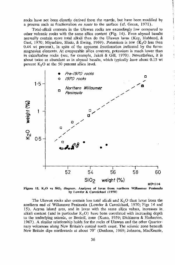
rocks have not been directly derived from the mantle, but have been modified by a process such as fractionation en route to the surface (ct. Green, 1971).
Total-alkali contents in the Ulawun rocks are exceedingly low compared to other volcanic rocks with the same silica content (Fig. 14). Even abyssal basalts normally contain more total alkali than do the Ulawun lavas (Kay, Hubbard, & Gast, 1970; Miyashiro, Shido, & Ewing, 1969). Potassium is low (K2 0 less than 0.44 wt percent), in spite of the apparent fractionation indicated by the ferro" magnesian elements. At comparable silica contents, potassium is much lower than in calcalkaline rocks (see, for example, Jakes & Gill, 1970). Nevertheless, it is about twice as abundant as in abyssal basalts, which typically have about 0.15 wt percent K2 0 at the 50 percent silica level.
1·5
--·0 ~ -.:E 1 0'1 'w ~
o (\./
~ 0·5 ,/
• o
o
Pre-1970 rocks 1970 rocks
Northern Willaumez Peninsula
",
o ", a/
o ", o ",/
", /'
,/
o ~~./r§ • •
///
",
•
52 54
Si02
56 weight (%)
o ./
//0
/
58 60
M(Pt)114
Figure 15. K20 vs Si02 diagram. Analyses of lavas from northern WiIIaumez Peninsula by Lowder & Carmichael (1970)
The Ulawun rocks also contain less total alkali and K2 0 than lavas from the northern end of Willaumez Peninsula (Lowder & Carmichael, 1970; Figs 14 and 15). Across island arcs, and in lavas with the same silica values, increases in alkali content (and in particular K2 0) have been correlated with increasing depth to the underlying seismic, or Benioff, zone (Kuno, 1959; Dickinson & Hatherton, 1967). A similar relationship holds for the rocks of Ulawun and the other Quarternary volcanoes along New Britain's central north coast. The seismic zone beneath New Britain dips northwards at about 70° (Denham, 1969; Johnson, MacKenzie,
36
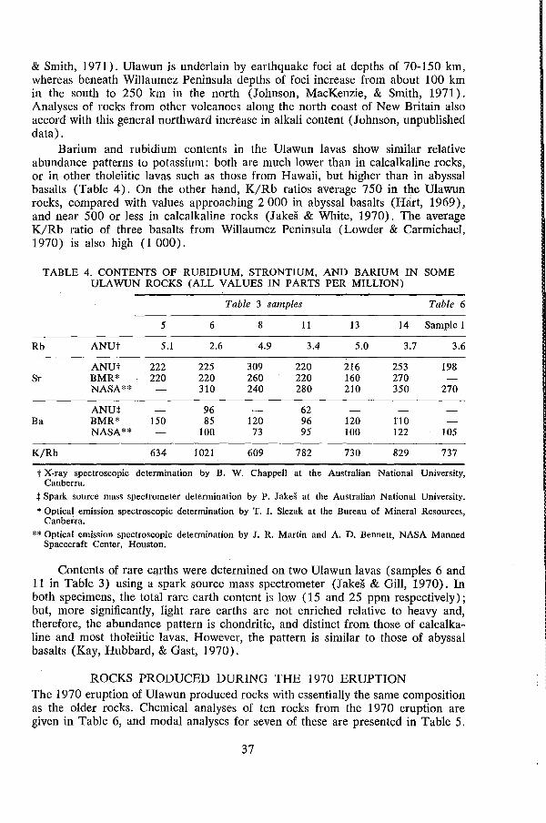
& Smith, 1971). Ulawun is underlain by earthquake foci at depths of 70-150 km, whereas beneath Willaumez Peninsula depths of foci increase from about 100 km in the south to 250 km in the north (Johnson, MacKenzie, & Smith, 1971). Analyses of rocks from other volcanoes along the north coast of New Britain also accord with this general northward increase in alkali content (Johnson, unpublished data) .
Barium and rubidium contents in the Ulawun lavas show similar relative abundance patterns to potassium: both are much lower than in calcalkaline rocks, or in other tholeiitic lavas such as those from Hawaii, but higher than in abyssal basalts (Table 4). On the other hand, K/Rb ratios average 750 in the Ulawun rocks, compared with values approaching 2 000 in abyssal basalts (Hart, 1969), and near 500 or less in calcalkaline rocks (Jakes & White, 1970). The average K/Rb ratio of three basalts from Willaumez Peninsula (Lowder & Carmichael, 1970) is also high (1000).
TABLE 4. CONTENTS OF RUBIDIUM, STRONTIUM, AND BARIUM IN SOME ULAWUN ROCKS (ALL VALUES IN PARTS PER MILLION)
Table 3 samples Table 6
5 6 8 11 13 14 Sample 1
Rb ANUt 5.1 2.6 4.9 3.4 5.0 3.7 3.6
ANUt 222 225 309 220 216 253 198 Sr BMR* 220 220 260 220 160 270
NASA** 310 240 280 210 350 270
ANut 96 62 Ba BMR* 150 85 120 96 120 110
NASA** 100 73 95 100 122 105
K/Rb 634 1021 609 782 730 829 737
t X-ray spectroscopic determination by B. W. Chappell at the Australian National University, Canberra.
:j: Spark source mass spectrometer determination by P. Jakes at the Australian National University.
* Optical emission spectroscopic determination by T. I. Slezak at the Bureau of Mineral Resource~, Canberra.
** Optical emission spectroscopic determination by J. R. Martin and A. D. Bennett, NASA Manned Spacecraft Center, Houston.
Contents of rare earths were determined on two Ulawun lavas (samples 6 and 11 in Table 3) using a spark source mass spectrometer (Jakes & Gill, 1970). In both specimens, the total rare earth content is lo.w (15 and 25 ppm respectively); but, more significantly, light rare earths are not enriched relative to heavy and, therefore, the abundance pattern is chondritic, and distinct from those of calcalkaline and most tholeiitic lavas. However, the pattern is similar to those of abyssal basalts (Kay, Hubbard, & Gast, 1970).
ROCKS PRODUCED DURING THE 1970 ERUPTION The 1970 eruption of Ulawun produced rocks with essentially the same composition as the older rocks. Chemical analyses of ten rocks from the 1970 eruption are given in Table 6, and modal analyses for seven of these are presented in Table 5.
37
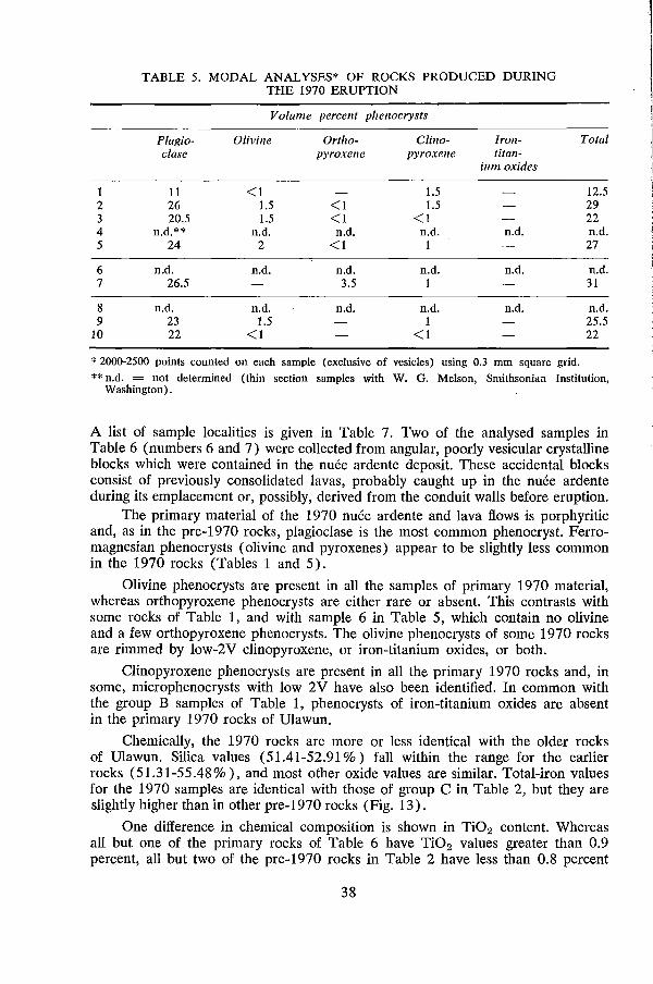
1 2 3 4 5
6 7
8 9
10
TABLE 5. MODAL ANALYSES* OF ROCKS PRODUCED DURING THE 1970 ERUPTION
Volume percent phenocrysts
Plagio- Olivine Ortlzo- Clino- Iron-clase pyroxene pyroxene titan-
ium oxides
11 <1 1.5 26 1.5 <1 1.5 20.5 1.5 <1 <1
n.d.** n.d. n.d. n.d. n.d. 24 2 <1 1
n.d. n.d. n.d. n.d. n.d. 26.5 3.5 1
n.d. n.d. n.d. n.d. n.d. 23 1.5 1 22 <1 <1
* 2000-2500 points counted on each sample (exclusive of vesicles) using 0.3 mm square grid.
Total
12.5 29 22 n.d. 27
n.d. 31
n.d. 25.5 22
** n.d. = not determined (thin section samples with W. G. Melson, Smithsonian Institution, Washington) .
A list of sample localities is given in Table 7. Two of the analysed samples in Table 6 (numbers 6 and 7) were collected from angular, poorly vesicular crystalline blocks which were contained in the nuee ardente deposit. These accidental blocks consist of previously consolidated lavas, probably caught up in the nuee ardente during its emplacement or, possibly, derived from the conduit walls before eruption.
The primary material of the 1970 nuee ardente and lava flows is porphyritic and, as in the pre-1970 rocks, plagioclase is the most common phenocryst. Ferromagnesian phenocrysts (olivine and pyroxenes) appear to be slightly less common in the 1970 rocks (Tables 1 and 5).
Olivine phenocrysts are present in all the samples of primary 1970 material, whereas orthopyroxene phenocrysts are either rare or absent. This contrasts with some rocks of Table 1, and with sample 6 in Table 5, which contain no olivine and a few orthopyroxene phenocrysts. The olivine phenocrysts of some 1970 rocks are rimmed by low-2V clinopyroxene, or iron-titanium oxides, or both.
Clinopyroxene phenocrysts are present in all the primary 1970 rocks and, in some, microphenocrysts with low 2V have also been identified. In common with the group B samples of Table 1, phenocrysts of iron-titanium oxides are absent in the primary 1970 rocks of Ulawun.
Chemically, the 1970 rocks are more or less identical with the older rocks of Ulawun. Silica values (51.41-52.91 %) fall within the range for the earlier rocks (51.31-55.48%), and most other oxide values are similar. Total-iron values for the 1970 samples are identical with those of group C in Table 2, but they are slightly higher than in other pre-I970 rocks (Fig. 13).
One difference in chemical composition is shown in TiO!! content. Whereas all but one of the primary rocks of Table 6 have Ti02 values greater than 0.9 percent, all but two of the pre-I970 rocks in Table 2 have less than 0.8 percent
38
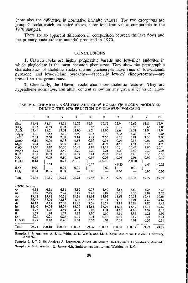
(note also the difference in normative ilmenite values). The two exceptions are group C rocks which, as stated above, show total-iron values comparable to the 1970 samples.
There are no apparent differences in composition between the lava flows and the primary nuee ardente material produced in 1970.
CONCLUSIONS
1. Ulawun rocks are highly porphyritic basalts and low-silica andesites in which plagioclase is the most common phenocryst. They show the petrographic characteristics of tholeiitic rocks; olivine phenocrysts have rims of low-calcium pyroxene, and low-calcium pyroxenes-especially low-2V clinopyroxenes-are present in the groundmass.
2. Chemically, the Ulawun rocks also show tholeiitic features. They are hypersthene normative, and alkali content is low for any given silica value. How-
TABLE 6. CHEMICAL ANALYSES AND CIPW NORMS OF ROCKS PRODUCED DURING THE 1970 ERUPTION OF ULAWUN VOLCANO
2 3 4 5 6 7 8 9 10
SiO, 51.41 52.5 52.51 52.77 52.9 51.51 52.9 52.62 52.8 52.9 TiO, 0.93 0.97 0.94 0.96 0.95 0.79 0.79 0.96 0.65 1.03 AI,O, 17.44 18.2 17.51 18.00 18.2 18.96 18.6 18.31 17.9 17.9 Fe,O, 3.30 2.55 3.10 2.99 4.15 2.72 3.35 3.23 2.75 2.85 FeO 7.03 7.50 7.00 7.14 5.95 7.50 6.70 6.81 7.30 7.00 MnO 0.19 0.09 0.18 0.14 0.09 0.16 0.09 0.14 0.09 0.09 MgO 5.74 5.15 5.30 4.98 4.90 4.92 4.50 4.94 5.15 4.90 CaO 11.00 9.85 10.50 10.48 9.85 11.14 10.1 10.45 9.90 10.1 Na,.O 2.27 2.35 2.40 2.29 2.20 2.24 2.20 2.40 2.30 2.25 K,O 0.32 0.37 0.38 0.37 0.41 0.32 0.40 0.40 0.35 0.38 .R,O, 0.09 0.09 0.10 0.08 0.09 0.07 0.08 0.08 9.09 0.10 H,O+ 0.14 1 0.22 <0.10 1 <0.10 1 <0.10 1
} 0.23 ~ 0.51 ~ 0.22 ~ 0.23 ~0.44 H,O- 0.04 J 0.04 0.01 J 0.03 J 0.01 J CO, 0.04 0.05 0.09 0.05 0.05 0.05 0.05
Total 99.94 100.19 100.27 100.21 99.96 100.36 99.99 100.35 99.77 99.78
CIPW Norms Q 4.84 6.53 6.31 7.10 9.78 4.50 8.85 6.60 7.26 8.23 or 1.89 2.19 2.2li 2.19 2.42 1.89 2.36 2.36 2.07 2.25 ab 19.21 19.88 20.31 19.38 18.61 18.96 18.61 20.31 19.45 19.04 an 36.45 38.02 35.88 37.74 38.58 40.74 39.70 38.01 37.49 37.62 di 14.13 8.15 12.30 11.25 7.59 11.59 7.83 10.88 8.80 9.45 hy 16.40 19.04 16.29 16.20 14.62 17.06 15.76 15.49 18.72 16.49 mt 4.78 3.70 4.49 4.34 6.02 3.94 4.86 4.68 3.99 4.13 iI 1.77 1.84 1.79 1.82 1.80 1.50 1.50 1.82 1.23 1.96 ap 0.20 0.21 0.22 0.19 0.21 0.16 0.19 0.19 0.21 0.24 Others 0.27 0.62 0.46 0.01 0.33 .03 0.34 0.01 0.55 0.34
Total 99.94 100.18 100.27 100.22 99.96 100.37 100.00 100.35 99.77 99.75
Samples 1, 3; Analysts: A. J. R. White, Z. L. Wasik, and M. J. Kaye, Australian National University, Canberra.
Samples 2, 5, 7, 9, 10; Analyst: A. Jorgenson, Australian Mineral Development Laboratories, Adelaide.
Samples 4, 6, 8; Analyst: E. Jarosewich, Smithsonian Institution, Washington D.C.
39
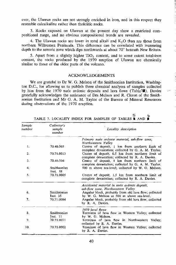
ever, the Ulawun rocks are not strongly enriched in iron, and in this respect they resemble calcalkaline rather than tholeiitic rocks.
3. Rocks exposed on Ulawun at the present day show a restricted compositional range, and no obvious compositional trends are revealed.
4. The Ulawun rocks are lower in total alkali and K2 0 than are those from northern Willaumez Peninsula. This difference can be correlated with increasing depth to the seismic zone which dips northwards at about 70° beneath New Britain.
5. Apart from a slightly higher Ti02 content, and to some extent total-iron content, the rocks produced by the 1970 eruption of Ulawun are chemically similar to those of the older parts of the volcano.
ACKNOWLEDGEMENTS
We are grateful to Dr W. G. Melson of the Smithsonian Institution, Washington D.C., for allowing us to publish three chemical analyses of samples collected by him from the 1970 nuee ardente deposits and lava flows (Table 11). Davies gratefully acknowledges the assistance of Drs Melson and R. Citron of the Smithsonian Institution and Mr G. A. M. Taylor of the Bureau of Mineral Resources during observations of the 1970 eruption.
Sample number
1.
2.
3.
4.
5.
6.
7.
8.
9.
10.
5 b TABLE 7. LOCALITY INDEX FOR SAMPLES OF TABLES. AND.
Collector's sample number
70.40.505
70.71.0013
70.40.504
Smithsonian Inst. 38 70.71.0005
Smithsonian Inst. 35 70.71.0004
Smithsonian Inst. 11 70.71.0011
70.71.0002
Locality description
Primary lllu?e ardente material, ash-flow zone, Northwestern Valley Centre of deposit, 1 km from northern limit of complete devastation; collected by G. A. M. Taylor. Centre of deposit, 0.5 km from northern limit of complete devastation; collected by R. A. Davies. Centre of deposit, 1 km from northern limit of complete devastation; collected by G. A. M. Taylor. 500 m above sea-level; collected by W. G. Melson.
Centre of deposit, 1.5 km from northern limit of complete devastation; collected by R. A. Davies.
Accidental material in n/l(!e ardente deposit, ash-flow zone, Northwestern Valley Angular block, probably from old lava flow; collected by W. G. Melson at 500 m above sea-level. Angular block, probably from old lava flow; collected by R. A. Davies.
1970 laval flows Terminus of lava flow in Western Valley; collected by W. G. Melson. Terminus of lava flow in Northwestern Valley; collected by R. A. Davies. Terminus of lava flow in Western Valley; collected by R. A. Davies.
40
REFERENCES ARAMAKI, S., 1956-The 1783 activity of Asama Volcano, part I. lap. I. Geol. Geogr.,
27, 189-229. BLAKE D. H., and MIEZITIS, Y., 1967-Geology of Bougainville and Buka Islands, New
Guinea. Bur. Miner. Resollr. Aust. Bull. 93. CHAYES, F., 1965-Titania and alumina content of oceanic and circumoceanic basalt. Miner.
Mag., 34, 126-31. DAVIES, R. A., 1970-The 1970 eruption of Mt Ulawun, New Britain. Smithson. Il1stn,
Centre for Short-Lived Phellomena, Rep. 15th May. DEER, W. A., HOWIE, R. A., and ZUSSMAN, J., 1963-ROCK FORMING MINERALS: 2, CHAIN
SILICATES. London, Longmalls, Green. DENHAM, D., 1969-Distribution of earthquakes in the New Guinea-Solomon Islands
region. I. geophys. Res., 74, 4290-9. DICKINSON, W. R., and HATHERTON, T., 1967-Andesitic volcanism and seismicity around
the Pacific. Science, 157, 801-3. FISHER, N. H., 1937-Geological report on the ascent of The Father Volcano, New Britain.
Geol. Slirv. Terr. N. GUill., unpubl. Rep. FISHER, N. H., 1939-Report on the volcanoes of the Territory of New Guinea. Geol. Bull.
N. GUill., 2. FISHER, N. H., 1940-The volcanoes of the Mandated Territory of New Guinea. Proc. 6th
Pacit. Sci. Cong., 2, 889-94. FISHER, N. H., 1957--Catalogue of the active volcanoes of the world including solfatara
fields. Part V: Melanesia. Int. volc., Ass., Naples. GREEN, D. H., 1971--Composition of basaltic magmas as indicators of conditions of origin:
application to oceanic volcanism. Phil. Trans. A, 268, 707-25. HAGGERTY, S. E., and BAKER, I., 1967-The alteration of olivine in basaltic and associated
lavas. I: High temperature alteration. Conlr. Miner. Petrol., 16, 233-57. HART, S. R., 1969-K, Rb, Cs contents and KjRb, KjCs ratios of fresh and altered sub
marine basalts. Earth plan. Sci. Lett., 6, 295-303. JAKES, P., and GILL, J., 1970-Rare earth elements and the island arc tholeiitic series. Earlh
plan. Sci. Lett., 9, 17-28. JAKES, P., and WHITE, A. J. R., 1970-KjRb ratios or rocks from island arcs. Geochem.
cosmochim. Acta, 34, 849-56. JOHNSON, R. W., MACKENZIE, D. E., and SMITH, I. R., 1971-Seismicity and late Cainozoic
volcanism in parts of Papua New Guinea. Tectonophysics, 12, 15-22. KAY, R., HUBBARD, N. J., and GAST, P. W., 1970-Chemical characteristics and origin of
oceanic ridge volcanic rocks. I. geophys. Res., 75(8), 1585-613. KRUMBElN, W. C., and SLOSS, L. L., 1963-STRATIGRAPHY AND SEDIMENTATION. Sail Francisco,
Freeman, 2nd Edn. KUNO H., 1950-Petrology of Hakone volcano and the adjacent areas, Japan. Bul/. geol.
Soc. Amer., 61, 957-1020. KUNO, H., 1959-Origin of Cenozoic petrographic provinces of Japan and surrounding areas.
Bull. vole., 20, 37-76. KUNO, H., 1960-High-alumina basalt. I. Petrol. 1, 121-145. LACROIX, A., 1904-LA MONTAGNE PELEE ET SES ERUPTIONS. Paris, Masson. LOWDER, G. G., 1970-The volcanoes and caldera of Talasea, New Britain: mineralogy.
Contr. Miner. Petrol., 26, 326-40. LOWDER, G. G., and CARMICHAEL, 1. S. E., 1970-The volcanoes and caldera of Talasea,
New Britain: geology and petrology. Bull. ge~l. Soc. Amer., 81, 17-38. MACDONALD, G. A., 1967-Forms and structures of extrusive basaltic rocks. In HESS, H. H.,
and POLDEVAART, A., edS-BASALTS. N.Y., Wiley. MACDONALD, G. A., 1968-A contribution to the petrology of Tutuila, American Samoa.
Geol. Rdsch., 57, 821-37. MACDONALD, G. A .. and ALCARAZ, A., 1965-Nuees ardentes of the 1948-1953 eruption of
Hibok-Hibok. Bull. volc., 18, 169-78. MACDONALD, G. A., and KATSURA, T., 1964--Chemical composition of Hawaiian lavas.
I. Petrol., 5, 82-133. MINAKAMI, T., 1960-Fundamental research for predicting volcanic eruptions, I: Earthquakes
and crustal deformations originating from volcanic activities. Bull. earthqu. Res. Inst., 38 496-544.
41
MIYASHIRO, A., SHIDO, F., and EWING, M., 1969-Diversity and origin of abyssal tholeiite from the Mid-Atlantic Ridge near 24° and 30° north latitude. COlltr. Miner. Petrol., 23, 38-52.
MOORE, J. G., and MELSON, W. G., 1969-Nuees ardentes of the 1968 eruption of Mayon Volcano, Philippines. Bull. volc., 33, 600-20.
MUIR, I. D., and LONG, J. V. P., 1965-Pyroxene relations in two Hawaiian hypersthenebearing basalts. Miller. Mag., 34, 358-69.
MUIR, I. E., TILLEY, C. E., and SCOON, J. H., 1957-Petrology of Hawaiian basalts, Part I: The picrite-basalts of Kilauea. Amer. 1. Sci., 264, 241-53.
PERRET, F. A, 1935-The eruption of Mt Pelee, 1929-1932. Carnegie Illstll Wash. Publ. 458. PRESNALL, D. C., 1966-The join forsterite-diopside-iron oxide and its bearing on the
crystallization of basaltic and ultramafic magmas. Amer. 1. Sci., 264, 753-809. SMITI:I, R. L., and BAILEY, R. A., 1962-Resurgent cauldrons: their relation to granitic ring
complexes and large volume rhyolitic ash flow fields. Int. Symp. Volc., Tokyo, May 1962, Abstr., 67-8.
SMITI:I, R. L., and BAILEY, R A., 1969-Resurgent cauldrons. Mem. geol. Soc. Amer. 116, 613-62.
STICE, G. D., 1968-Petrography of the Manula Islands. COlltr. Miller. Petrol., 19, 343-57. TAYLOR, G. A. M., 1958-The 1951 eruption of Mount Lamington, Papua. Bur. Miller.
Resour. Aust. Bull. 38. TAYLOR, G. A M .. 1963---Seismic and tilt phenomena preceding a Pelean eruption from a
basaltic volcano. Bull. vole., 26, 5-11. TAYLOR, S. R., WHITE, A. J. R, EWART, A, and DUNCAN, A R, 1971-Nickel in high
alumina basalts: a reply. Geochem. cosmochim. Acta, 35, 525-8. UPTON, B. G. J., and WADSWORTH, W. J., 1965-Geology of Reunion Island, Indian Ocean.
Nature, 207, 151-4. WATERS, A C., 1961---Stratigraphic and' lithologic variations in the Columbia River Basalts.
Amer. 1. Sci., 259,583-611. WILLIAMS, C. E. F., and WARDEN, A J., 1964-New Hebrides Anglo-French Condominium
Progress report of the Geological Survey for the period 1959-1962. Geol. Surv. N. Rebr., 46-51.
YODER, H. S., and TILLEY, C. E., 1962-Origin of basalt magmas: an experimental study of natural and synthetic rock systems. 1. Petrol., 3, 342-532.
42