Embed Size (px)
Citation preview
UNDERSTANDING CULTURAL LANDSCAPES
IN THAI URBAN CONTEXT:
BANGKOK AS A NEGLECTING WATER-BASED CITY
Weeraphan Shinawatra, Ph.D.
Dean of the School of Architecture and Design, KMUTT
ABSTRACT
This article is attempted to explain the cultural
landscape definition that should appropriated with
Thailand and why the cultural landscape should be in the
category of Urban Planning study and analysis in
Thailand. The cultural landscape study should provide
more understanding the old town and cities urban context
in Thailand and increasing local knowledge and
awareness to prevent destroying its cultural heritage and
footprint in the past. The concept of “Cultural
Landscape” should be part of “Building Culture” design
for all architect and urban planner. One of the case is
Bangkok, the water city in the past that had been slowly
eliminated by means of its rapidly globalization
&consumption development expansion while neglecting
the city’s cultural identity of water as heritage.
Furthermore, the study introduced some Urban Planning
policies and appropriated solution for Bangkok: The
Flood Zone.
Key words: Cultural Landscape, Thai Urban Planning
Context, Water-based City, Flood Zone.
1. CULTURAL LANDSCAPE DEFINITIONS
The term “Cultural Landscape” is very new and
recently introduced to the field of Urban Planning &
Design study, also in the field of heritage conservation
study too. In fact, while most of Urban Planner is more
familiar to the word “Built Environment”, conservationist
should recognized the word “setting” in their sense.
Those two words had partly the same meaning of
“Cultural Landscapes” too. So we may say that
“Cultural Landscape” is as a part of “Built Environment”
and “setting”. Sometime the explanation through the term
‘Built Environment’ did not covered some cultural issue
and ‘Setting’ in the term of culture, forgot to explained
about its natural relationship. To my opinion, the word
“Cultural Landscape” has its specific meaning according
to different part of the world and needed different
interpretation. Here are some definitions about “Cultural
Landscape”:
1.1 UNESCO ‘s term of Cultural Landscape
(http://whc.unesco.org/en/culturallandscape#1)
The Committee acknowledged that cultural
landscapes represent the "combined works of nature and
of man" designated in Article 1 of the Convention. They
are illustrative of the evolution of human society and
settlement over time, under the influence of the physical
constraints and/or opportunities presented by their natural
environment and of successive social, economic and
cultural forces, both external and internal.
The term "cultural landscape" embraces a
diversity of manifestations of the interaction between
humankind and its natural environment. Cultural
landscapes often reflect specific techniques of sustainable
land-use, considering the characteristics and limits of the
natural environment they are established in, and a specific
spiritual relation to nature. Protection of cultural
landscapes can contribute to modern techniques of
sustainable land-use and can maintain or enhance natural
values in the landscape. The continued existence of
traditional forms of land-use supports biological diversity
in many regions of the world. The protection of
traditional cultural landscapes is therefore helpful in
maintaining biological diversity.
In this sense, UNESCO had mentioned generally
a standard term of Cultural Landscape for the state parties
to concern and interpret for their own term and meaning.
1.2 U.S. National park’s term of Cultural
Landscape
A geographic area, including both cultural and
natural resources & the wildlife or domestic animals
therein, associated with an historic event, activity, or
person, or that exhibits other cultural or aesthetic values.
4 types recognized:
1.2.1 Historic site
1.2.2 Historic designed landscape
1.2.3 Historic vernacular landscape (everyday landscape)
1.2.4 Ethnographic (Indigenous) landscape
1.3. Australia ICOMOS’s term of Cultural
Landscape BURRA CHARTER
(http://australia.icomos.org/wp-content/uploads/BUR
RA-CHARTER-1999_charter-only.pdf)
For the purposes of this Charter:
1.3.1 Place means site, area, land, landscape, building or
other work, group of buildings or other works, and may
include components, contents, spaces and views.
1.3.2 Cultural significance means aesthetic, historic,
scientific, social or spiritual value for past, present or
future generations. Cultural significance is embodied in
the place itself, its fabric, setting, use, associations,
meanings, records, related places and related objects.
Places may have a range of values for different
individuals or groups.
13.3 Fabric means all the physical material of the place
including components, fixtures, contents, and objects.
After, Emeritus Professor Ken Taylor, a member
of Australian ICOMOS and a visiting fellow to Humanities
Research Center, the Australian National University in
Canberra, had defined the term of “cultural landscape” as
We are surrounded by landscapes
that people have settled, modified, or
altered over time. These landscapes are
“cultural landscapes”, the ordinary,
everyday landscapes which surround us
and in which we conduct our activities.
They are the result of human
intervention in the natural landscape
and present a record of human activity,
human values and ideologies. In this
way they do not simply represent
physical changes brought about by
human intervention. They also
represent evidence of material culture
manifested in the landscape and
thereby reflect human relationships
with our surrounds. They are an
inextricable and coherent part of our
intellectual and cultural background.
Cultural landscapes are literally
an imprint of human history. They can
tell us, if we care to read and interpret
them, something about an achievement
and values of our predecessors. In this
way cultural landscapes are symbols of
who are and can serve to and remind us
of the past. Because they are records of
past and present actions, cultural
landscapes are product of change. They
embody physical changes which in turn
reflect evolving attitudes towards the
landscape. It is important that we learn
to interpret cultural landscapes as
living history and as part of our
national identity. They contain a wealth
of evidence of our social and material
history with which we readily associate
heritage value. (Taylor,______: 3)
From the beginning, the Australian concern
more on ‘every day landscape’ of their way of living in
the past after they landed on this continent a hundred
years ago and lastly they founded that they should
respected and take the world vision, way of living and
culture of the Aborigine or “Indigenous” people, who
lived before them, into account of the definition of
cultural landscapes reflected in the definition of cultural
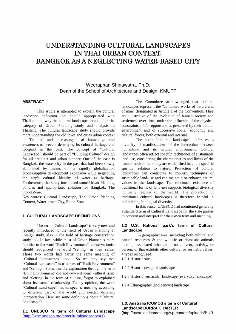
significance in Burra Charter too. The Auluru-Kata Tjuta
National Park is one of the cases of Cultural & Natural
Heritage to applied using this definition in Australia
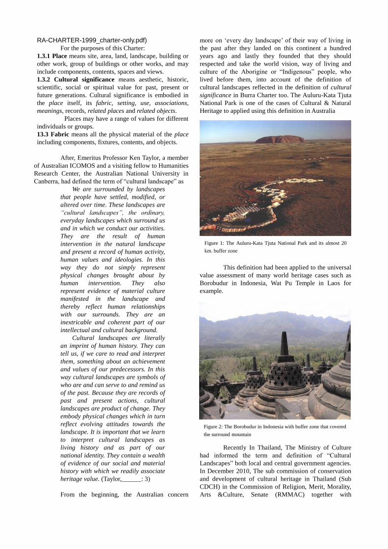
This definition had been applied to the universal
value assessment of many world heritage cases such as
Borobudur in Indonesia, Wat Pu Temple in Laos for
example.
Recently In Thailand, The Ministry of Culture
had informed the term and definition of “Cultural
Landscapes” both local and central government agencies.
In December 2010, The sub commission of conservation
and development of cultural heritage in Thailand (Sub
CDCH) in the Commission of Religion, Merit, Morality,
Arts &Culture, Senate (RMMAC) together with
Figure 1: The Auluru-Kata Tjuta National Park and its almost 20
km. buffer zone
Figure 2: The Borobudur in Indonesia with buffer zone that covered
the surround mountain
ICOMOS Association of Thailand had developed a draft
Thailand Charter for Cultural Heritage Management and
prepare to apply for the whole country and after will send
to UNESCO through ICOMOS International Committee
for declaration. Their definition of the term of “Cultural
Landscape” is very interesting.
1.4 Thailand Charter on the Management of
Cultural Heritage Site (3rd
Commission Office,
Secretary to Senate Office. 2010: 18)
“Cultural landscape” means
The geography had been affected by human
intervention and changed the natural landscape. This
imprint indicated the relationship between human and
nature and reflected human’s way of living, belief and
religious faith where formed the unique identity through
time.
To my opinion, most of the significance of
“Cultural Landscape” in Thailand related more to
ancestor‘s world vision & wisdom and religious believed,
especially Buddhism and Hinduism not only the
‘ordinary or everyday landscape’.
2. OLD TOWN & CITIES CONTEXTS IN THAILAND
AND URBAN PROBLEMS
Like others Asian country, many big cities in
Thailand had been developed, growth and expanded on
top of their ancient town or settlement. According to the
studied of Thiva Suphajanya, the geologist, in the book of
225 years of Krung Rattanakosin referred to his found of
the important evidences that the ancient settlements in the
central plain of Chao Phraya river were located in the
area comprised water courses that provided convenient
access to the sea and suitable land for agriculture. He also
found that those of manmade canals linking some ancient
settlements to the transportation water courses (BMA
City Planning Department, 2009: 54). This local wisdom
had been applied until Ayutthaya period. We can assumed
that Ayutthaya was founded in the strategic location for
controlling trading route by waterway and acted as the
ancient important port town, a water based
commercial center, a self protect fortify town surrounded
by waterway with an unique water way of living that
inherited to Bangkok in later period.
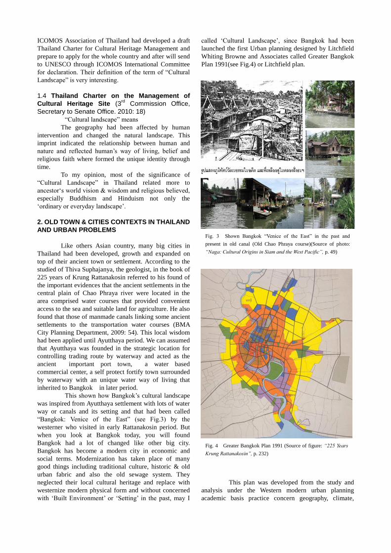
This shown how Bangkok’s cultural landscape
was inspired from Ayutthaya settlement with lots of water
way or canals and its setting and that had been called
“Bangkok: Venice of the East” (see Fig.3) by the
westerner who visited in early Rattanakosin period. But
when you look at Bangkok today, you will found
Bangkok had a lot of changed like other big city.
Bangkok has become a modern city in economic and
social terms. Modernization has taken place of many
good things including traditional culture, historic & old
urban fabric and also the old sewage system. They
neglected their local cultural heritage and replace with
westernize modern physical form and without concerned
with ‘Built Environment’ or ‘Setting’ in the past, may I
called ‘Cultural Landscape’, since Bangkok had been
launched the first Urban planning designed by Litchfield
Whiting Browne and Associates called Greater Bangkok
Plan 1991(see Fig.4) or Litchfield plan.
This plan was developed from the study and
analysis under the Western modern urban planning
academic basis practice concern geography, climate,
Fig. 3 Shown Bangkok “Venice of the East” in the past and
present in old canal (Old Chao Phraya course)(Source of photo:
“Naga: Cultural Origins in Siam and the West Pacific”, p. 49)
Fig. 4 Greater Bangkok Plan 1991 (Source of figure: “225 Years
Krung Rattanakosin”, p. 232)
population and changes, socio-economic, traffic and
transportation and land use planning study (BMA City
Planning Department, 2009: 232) but without the cultural
aspect study. No one understood values of cultural
heritage by that time and denied conservation. May this
effected the disappearing of Bangkok local heritage in
later stage.
Recently, The Faculty of Architecture and
Planning, Thammasat University had released a final
report on Study & Research on Housing and Community
Standard for Town Identity and Value sustainability for
the Housing Authority of Thailand which indicated that
most of the 140 Traditional communities with habitat
living until today in Thailand were rather situated next to
river & canal and railway than road (Thammasat
University, 2010: 9). This is to confirm that Ancient
towns in Thailand mostly are water-based community.
Flooding is a critical issue in Thailand. Each
year, flooding caused a severe damage throughout the
country. The government had spent more and more
billion baht every year for the water way blocking roads
repair and box culvert. Imagine how we have to pay for it
every year. To my point of view, most of the water
barricade along the upper part of Chao Phraya River
basin constructed by several local administration
authorities caused the serious flooding in Singhburi and
Sukhuthai province many years ago. Because of those
barricade that blocked and narrowed down the river slow
down the flow rate of the water from the north and turn to
be flooding over the Chao Phraya basin. If every town
along the river did the same barricade to maintain the
embankment of the country, then Chao Phraya River will
turn to be a great sewage pipe in the world! Those
against-natured technology should be solve the problem
in short term only but it will lead to the more bigger
problem and the more complicate , expensive technology
to be solve continuously forever. How to prevent the
water flow from the north turn to be water flood? We had
to take effort and all our strength to preserve and develop
the ecology system to maintain the annual water flow and
comply with the contemporary Thais way of living. By
preserving canals, dike, natural pond and swam area to
provide the water flow way and distribute the water
quantity not to over flow to the living basin nearby
(Shinawatra, 2002: 242).
Again, a water diversion mission from Chao
Phraya River to Ayutthaya West bank and Nakorn
Phrathom province last year for Bangkok flooding
protection helped Bangkok saved but instead, created
flood problems to local communities and their crop fields
surrounded Bangkok and got severe damaged to local
infrastructure with lot of budget for repair. This is the
absurd solution to resolve flooding problem!
3. CASES FOR UNDERSTANDING & INTERPRET
THE CULTURAL LANDSCAPE IN THAI URBAN
CONTEXT
3.1 Case in the North: Chiang Saen: The
originated Capital City with Muang Fai, an
ancient irrigation system, that formed Lanna
Kingdom.
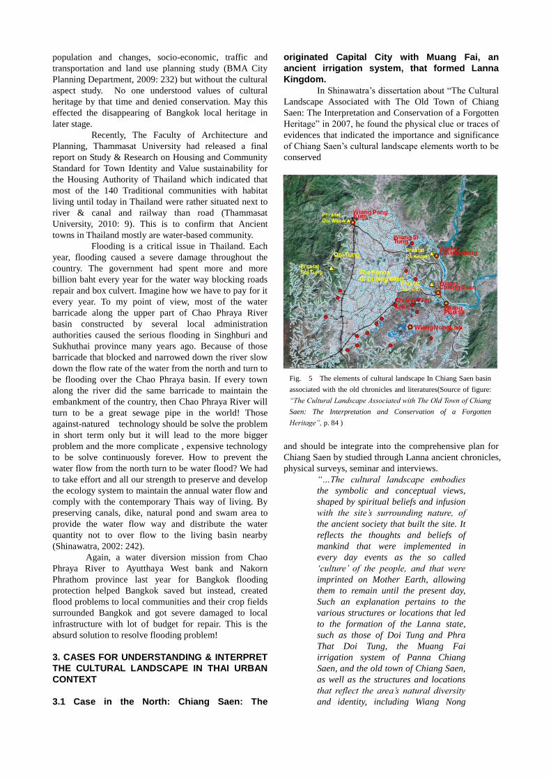
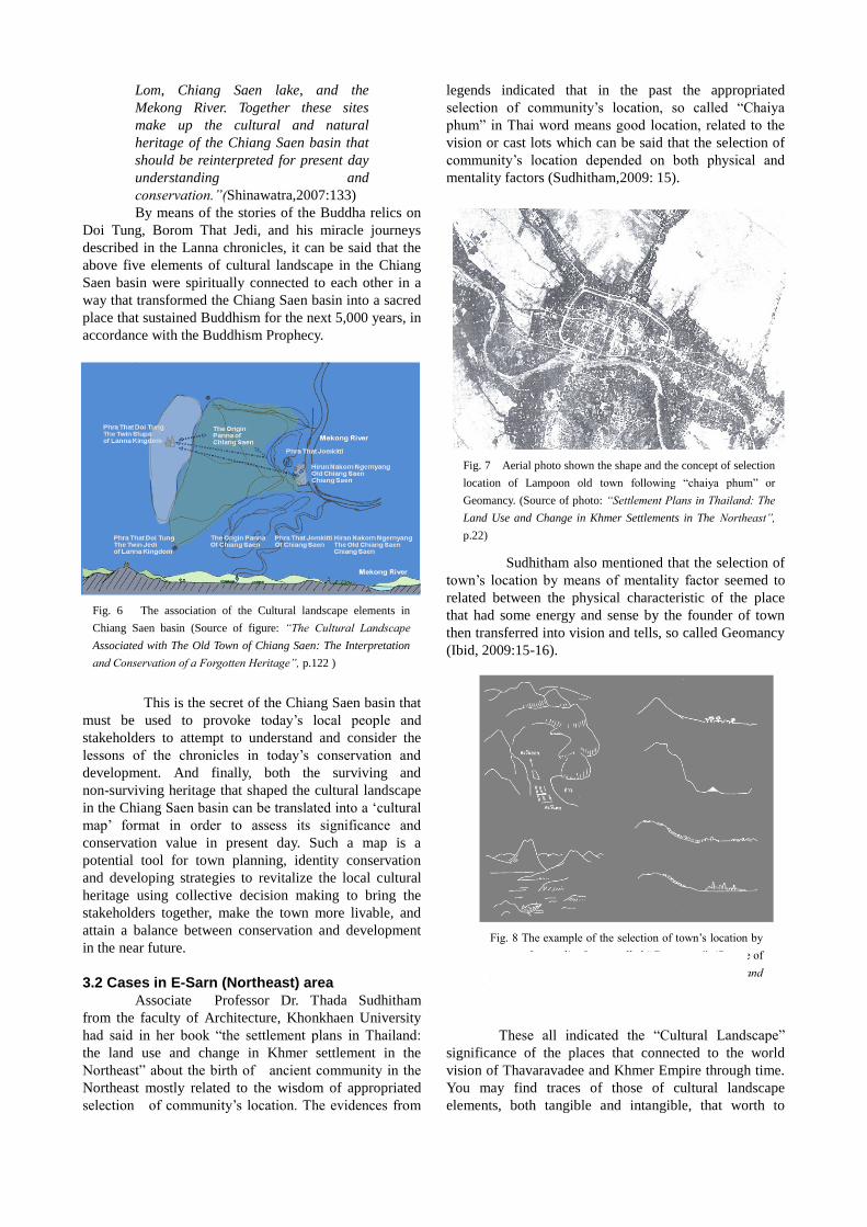
In Shinawatra’s dissertation about “The Cultural
Landscape Associated with The Old Town of Chiang
Saen: The Interpretation and Conservation of a Forgotten
Heritage” in 2007, he found the physical clue or traces of
evidences that indicated the importance and significance
of Chiang Saen’s cultural landscape elements worth to be
conserved
and should be integrate into the comprehensive plan for
Chiang Saen by studied through Lanna ancient chronicles,
physical surveys, seminar and interviews.
“…The cultural landscape embodies
the symbolic and conceptual views,
shaped by spiritual beliefs and infusion
with the site’s surrounding nature, of
the ancient society that built the site. It
reflects the thoughts and beliefs of
mankind that were implemented in
every day events as the so called
‘culture’ of the people, and that were
imprinted on Mother Earth, allowing
them to remain until the present day,
Such an explanation pertains to the
various structures or locations that led
to the formation of the Lanna state,
such as those of Doi Tung and Phra
That Doi Tung, the Muang Fai
irrigation system of Panna Chiang
Saen, and the old town of Chiang Saen,
as well as the structures and locations
that reflect the area’s natural diversity
and identity, including Wiang Nong
Fig. 5 The elements of cultural landscape In Chiang Saen basin
associated with the old chronicles and literatures(Source of figure:
“The Cultural Landscape Associated with The Old Town of Chiang
Saen: The Interpretation and Conservation of a Forgotten
Heritage”, p. 84 )
Lom, Chiang Saen lake, and the
Mekong River. Together these sites
make up the cultural and natural
heritage of the Chiang Saen basin that
should be reinterpreted for present day
understanding and
conservation.”(Shinawatra,2007:133)
By means of the stories of the Buddha relics on
Doi Tung, Borom That Jedi, and his miracle journeys
described in the Lanna chronicles, it can be said that the
above five elements of cultural landscape in the Chiang
Saen basin were spiritually connected to each other in a
way that transformed the Chiang Saen basin into a sacred
place that sustained Buddhism for the next 5,000 years, in
accordance with the Buddhism Prophecy.
This is the secret of the Chiang Saen basin that
must be used to provoke today’s local people and
stakeholders to attempt to understand and consider the
lessons of the chronicles in today’s conservation and
development. And finally, both the surviving and
non-surviving heritage that shaped the cultural landscape
in the Chiang Saen basin can be translated into a ‘cultural
map’ format in order to assess its significance and
conservation value in present day. Such a map is a
potential tool for town planning, identity conservation
and developing strategies to revitalize the local cultural
heritage using collective decision making to bring the
stakeholders together, make the town more livable, and
attain a balance between conservation and development
in the near future.
3.2 Cases in E-Sarn (Northeast) area
Associate Professor Dr. Thada Sudhitham
from the faculty of Architecture, Khonkhaen University
had said in her book “the settlement plans in Thailand:
the land use and change in Khmer settlement in the
Northeast” about the birth of ancient community in the
Northeast mostly related to the wisdom of appropriated
selection of community’s location. The evidences from
legends indicated that in the past the appropriated
selection of community’s location, so called “Chaiya
phum” in Thai word means good location, related to the
vision or cast lots which can be said that the selection of
community’s location depended on both physical and
mentality factors (Sudhitham,2009: 15).
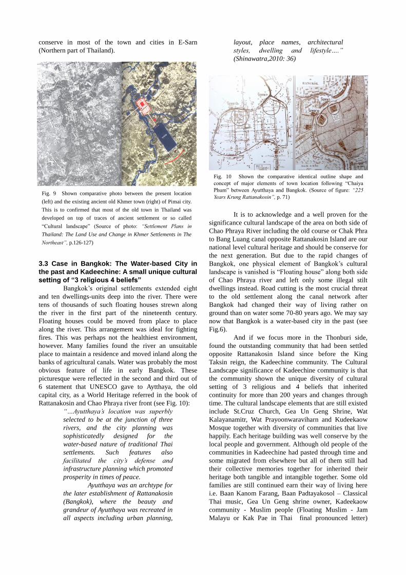
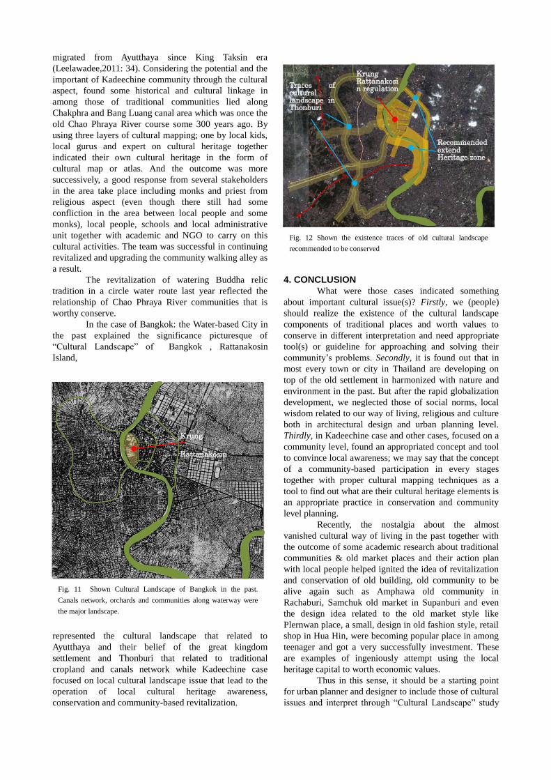
Sudhitham also mentioned that the selection of
town’s location by means of mentality factor seemed to
related between the physical characteristic of the place
that had some energy and sense by the founder of town
then transferred into vision and tells, so called Geomancy
(Ibid, 2009:15-16).
These all indicated the “Cultural Landscape”
significance of the places that connected to the world
vision of Thavaravadee and Khmer Empire through time.
You may find traces of those of cultural landscape
elements, both tangible and intangible, that worth to
Fig. 6 The association of the Cultural landscape elements in
Chiang Saen basin (Source of figure: “The Cultural Landscape
Associated with The Old Town of Chiang Saen: The Interpretation
and Conservation of a Forgotten Heritage”, p.122 )
Fig. 7 Aerial photo shown the shape and the concept of selection
location of Lampoon old town following “chaiya phum” or
Geomancy. (Source of photo: “Settlement Plans in Thailand: The
Land Use and Change in Khmer Settlements in The Northeast”,
p.22)
Fig. 8 The example of the selection of town’s location by
means of mentality factor, called “Geomancy”. (Source of
photo: “Settlement Plans in Thailand: The Land Use and
Change in Khmer Settlements in the Northeast”, p.16)
conserve in most of the town and cities in E-Sarn
(Northern part of Thailand).
3.3 Case in Bangkok: The Water-based City in
the past and Kadeechine: A small unique cultural
setting of “3 religious 4 beliefs”
Bangkok’s original settlements extended eight
and ten dwellings-units deep into the river. There were
tens of thousands of such floating houses strewn along
the river in the first part of the nineteenth century.
Floating houses could be moved from place to place
along the river. This arrangement was ideal for fighting
fires. This was perhaps not the healthiest environment,
however. Many families found the river an unsuitable
place to maintain a residence and moved inland along the
banks of agricultural canals. Water was probably the most
obvious feature of life in early Bangkok. These
picturesque were reflected in the second and third out of
6 statement that UNESCO gave to Aytthaya, the old
capital city, as a World Heritage referred in the book of
Rattanakosin and Chao Phraya river front (see Fig. 10):
“…Ayutthaya’s location was superbly
selected to be at the junction of three
rivers, and the city planning was
sophisticatedly designed for the
water-based nature of traditional Thai
settlements. Such features also
facilitated the city’s defense and
infrastructure planning which promoted
prosperity in times of peace.
Ayutthaya was an archtype for
the later establishment of Rattanakosin
(Bangkok), where the beauty and
grandeur of Ayutthaya was recreated in
all aspects including urban planning,
layout, place names, architectural
styles, dwelling and lifestyle….”
(Shinawatra,2010: 36)
It is to acknowledge and a well proven for the
significance cultural landscape of the area on both side of
Chao Phraya River including the old course or Chak Phra
to Bang Luang canal opposite Rattanakosin Island are our
national level cultural heritage and should be conserve for
the next generation. But due to the rapid changes of
Bangkok, one physical element of Bangkok’s cultural
landscape is vanished is “Floating house” along both side
of Chao Phraya river and left only some illegal stilt
dwellings instead. Road cutting is the most crucial threat
to the old settlement along the canal network after
Bangkok had changed their way of living rather on
ground than on water some 70-80 years ago. We may say
now that Bangkok is a water-based city in the past (see
Fig.6).
And if we focus more in the Thonburi side,
found the outstanding community that had been settled
opposite Rattanakosin Island since before the King
Taksin reign, the Kadeechine community. The Cultural
Landscape significance of Kadeechine community is that
the community shown the unique diversity of cultural
setting of 3 religious and 4 beliefs that inherited
continuity for more than 200 years and changes through
time. The cultural landscape elements that are still existed
include St.Cruz Church, Gea Un Geng Shrine, Wat
Kalayanamitr, Wat Prayoonwaraviharn and Kudeekaow
Mosque together with diversity of communities that live
happily. Each heritage building was well conserve by the
local people and government. Although old people of the
communities in Kadeechine had pasted through time and
some migrated from elsewhere but all of them still had
their collective memories together for inherited their
heritage both tangible and intangible together. Some old
families are still continued earn their way of living here
i.e. Baan Kanom Farang, Baan Padtayakosol – Classical
Thai music, Gea Un Geng shrine owner, Kadeekaow
community - Muslim people (Floating Muslim - Jam
Malayu or Kak Pae in Thai final pronounced letter)
Fig. 9 Shown comparative photo between the present location
(left) and the existing ancient old Khmer town (right) of Pimai city.
This is to confirmed that most of the old town in Thailand was
developed on top of traces of ancient settlement or so called
“Cultural landscape” (Source of photo: “Settlement Plans in
Thailand: The Land Use and Change in Khmer Settlements in The
Northeast”, p.126-127)
Fig. 10 Shown the comparative identical outline shape and
concept of major elements of town location following “Chaiya
Phum” between Ayutthaya and Bangkok. (Source of figure: “225
Years Krung Rattanakosin”, p. 71)
migrated from Ayutthaya since King Taksin era
(Leelawadee,2011: 34). Considering the potential and the
important of Kadeechine community through the cultural
aspect, found some historical and cultural linkage in
among those of traditional communities lied along
Chakphra and Bang Luang canal area which was once the
old Chao Phraya River course some 300 years ago. By
using three layers of cultural mapping; one by local kids,
local gurus and expert on cultural heritage together
indicated their own cultural heritage in the form of
cultural map or atlas. And the outcome was more
successively, a good response from several stakeholders
in the area take place including monks and priest from
religious aspect (even though there still had some
confliction in the area between local people and some
monks), local people, schools and local administrative
unit together with academic and NGO to carry on this
cultural activities. The team was successful in continuing
revitalized and upgrading the community walking alley as
a result.
The revitalization of watering Buddha relic
tradition in a circle water route last year reflected the
relationship of Chao Phraya River communities that is
worthy conserve.
In the case of Bangkok: the Water-based City in
the past explained the significance picturesque of
“Cultural Landscape” of Bangkok , Rattanakosin
Island,
represented the cultural landscape that related to
Ayutthaya and their belief of the great kingdom
settlement and Thonburi that related to traditional
cropland and canals network while Kadeechine case
focused on local cultural landscape issue that lead to the
operation of local cultural heritage awareness,
conservation and community-based revitalization.
4. CONCLUSION
What were those cases indicated something
about important cultural issue(s)? Firstly, we (people)
should realize the existence of the cultural landscape
components of traditional places and worth values to
conserve in different interpretation and need appropriate
tool(s) or guideline for approaching and solving their
community’s problems. Secondly, it is found out that in
most every town or city in Thailand are developing on
top of the old settlement in harmonized with nature and
environment in the past. But after the rapid globalization
development, we neglected those of social norms, local
wisdom related to our way of living, religious and culture
both in architectural design and urban planning level.
Thirdly, in Kadeechine case and other cases, focused on a
community level, found an appropriated concept and tool
to convince local awareness; we may say that the concept
of a community-based participation in every stages
together with proper cultural mapping techniques as a
tool to find out what are their cultural heritage elements is
an appropriate practice in conservation and community
level planning.
Recently, the nostalgia about the almost
vanished cultural way of living in the past together with
the outcome of some academic research about traditional
communities & old market places and their action plan
with local people helped ignited the idea of revitalization
and conservation of old building, old community to be
alive again such as Amphawa old community in
Rachaburi, Samchuk old market in Supanburi and even
the design idea related to the old market style like
Plernwan place, a small, design in old fashion style, retail
shop in Hua Hin, were becoming popular place in among
teenager and got a very successfully investment. These
are examples of ingeniously attempt using the local
heritage capital to worth economic values.
Thus in this sense, it should be a starting point
for urban planner and designer to include those of cultural
issues and interpret through “Cultural Landscape” study
Fig. 11 Shown Cultural Landscape of Bangkok in the past.
Canals network, orchards and communities along waterway were
the major landscape.
Krung
Rattanakosin
Fig. 12 Shown the existence traces of old cultural landscape
recommended to be conserved
Krung Rattanakosin regulation Traces of
cultural landscape in Thonburi
Recommended extend Heritage zone
in their practice. Should it appropriate to address the
“Cultural Landscape” concept as part of urban planning
and design process yet?
5. SUGGESTIONS FOR SAFEGUARDING CHAO
PHRAYA BASIN CULTURAL LANDSCAPE BY
MEANS OF URBAN PLANNING POLICIES AND
REGULATION
Lastly come to the final chapter, according to
my study about zoning allocation in Bangkok and its
neighborhood provincial comprehensive plan, indicated
threats to change lots of local cultural heritage places and
districts in various edge zone areas surround Bangkok.
If we realize the cultural significance of
Bangkok as the water-based city, may we can be convert
these cultural capital and values to support economic
value by safeguarding Chao Phraya basin and Bangkok to
remain as the water-based city before it is too late. I
would like to propose to include the “Building open
ground” concept and “Flood Zone” on to Bangkok and
surrounding province comprehensive plan:
5.1 The “Building open ground” concept of
‘Living with Water’
Following Thai local wisdom of adaptability to
live with water in the past i.e. the old Thai traditional stilt
house and Bang Li (see Fig. 14), a vanished amphibian
traditional community in the past, every building in the
flood zone should leave ground level open or flexible as
much as possible. Finishing materials should sustain the
water flood and easy to clean up. All electric wire and
socket should be raise up above the maximum water
flood level for safety. Also need to have a proper
eco-waste water septic system during flooding instead of
the traditional one. The important part of this concept is
not allowed 100% of landfill for new development to
prevent water flood blocking. At lease more than 50%
of land, depend on each district agreement, should be
maintain as original or with pond. A proper high ground
for community should be consider depend on require.
Recommended to have a proper urban study to provide
“Living with water” zone both side of Bangkok
Metropolitan as a guideline for specific zoning of each
area.
This regulation can be apply to Thonburi and
Nonburi area to comply with their original topography
and to maintain local cultural landscape. And also in
Meanburi on the east side of Bangkok including Prathum
Thani province in the northeast area where the biggest
irrigation canal had been constructed for over 100 years
in King Rama 5 era still be existed, The Rangsit irrigation
canal system (see Fig.15, 16).
Fig. 13 Shown the water flood blocking problem zone
when combine comprehensive plan surround Bangkok
together. On the west side of Nonburi area shown the
unlogic zone of town center located on both side of ring
road while agriculture and water storage zone located
underneath on the south side. On the east side there are
no zoning plan apply on northwest side of Bangkok and
there were some possibility development area would
sprawl along Rangsit-Nakorn nayok road and
Bangna-Trad road which align blocking water flood
direction that caused by 100% landfill development.
Ring
Road
Fig. 14 Shown the old wisdom of ‘Living with Water’ that led to
the concept of “Building open ground” to be propose in Bkk.
comprehensive plan. )(Source of photo: “Naga: Cultural Origins in
Siam and the West Pacific”, p. 102)
These canals system represented the history and
evidence of new technique in canal system design for
irrigate rice fields for mass production in the late 19th
century of the world. But today function for those canals
system served only control water flood from the north of
Bangkok with water gate. So it is worth cultural value to
be conserve too. Lately, more development on housing
estate with low cost investment had been shifted to the
area with a concept of landfill without understanding this
specific cultural environment. How can we maintain the
cultural heritage value of this place while allowing proper
development? The answer is we must keep the fabric
pattern of these canals and maintaining its hydraulic
properties and control land use as a water garden city
with low density community for today use with some
incentive to land owner.
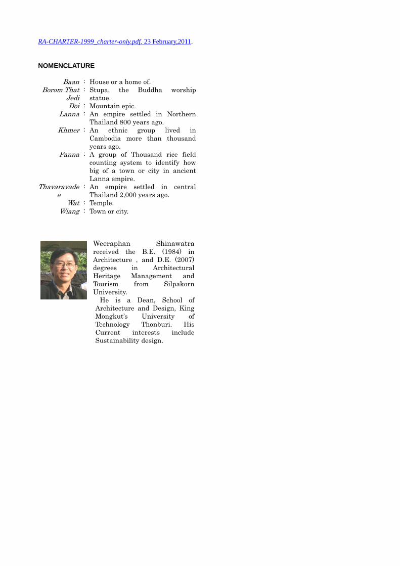
5.2 The “Flood Zone” concept
Similar to the Earthquake Zone, the Water
Flood Zone concept for Chao Phraya basin town and
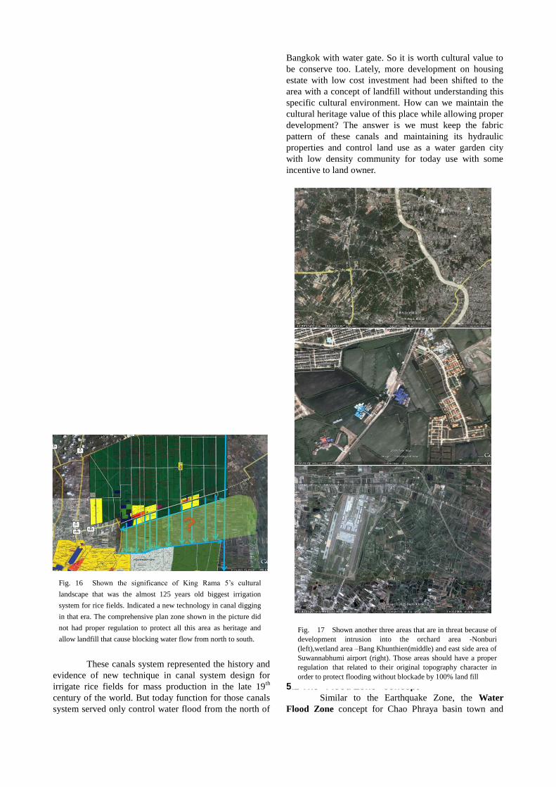
Fig. 16 Shown the significance of King Rama 5’s cultural
landscape that was the almost 125 years old biggest irrigation
system for rice fields. Indicated a new technology in canal digging
in that era. The comprehensive plan zone shown in the picture did
not had proper regulation to protect all this area as heritage and
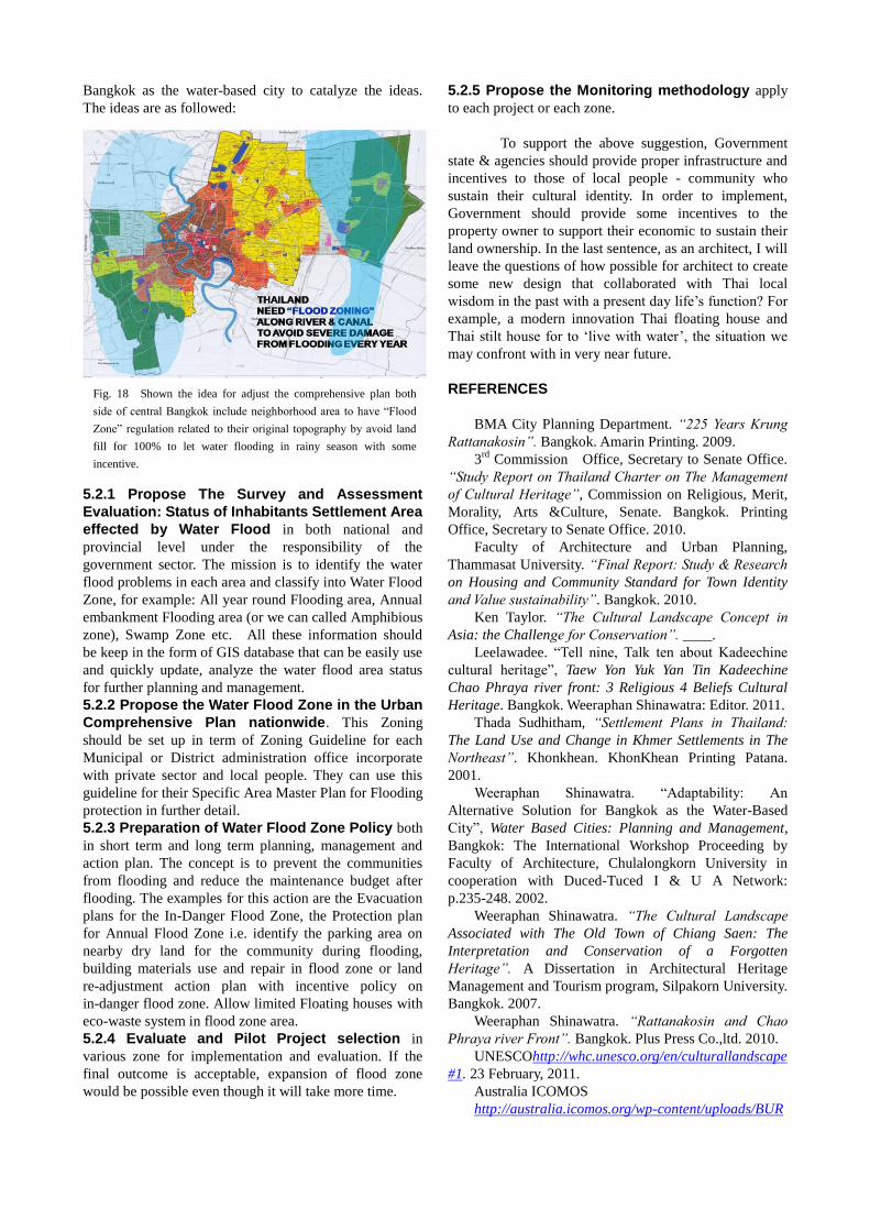
allow landfill that cause blocking water flow from north to south. Fig. 17 Shown another three areas that are in threat because of
development intrusion into the orchard area -Nonburi
(left),wetland area –Bang Khunthien(middle) and east side area of
Suwannabhumi airport (right). Those areas should have a proper
regulation that related to their original topography character in
order to protect flooding without blockade by 100% land fill
Bangkok as the water-based city to catalyze the ideas.
The ideas are as followed:
5.2.1 Propose The Survey and Assessment
Evaluation: Status of Inhabitants Settlement Area
effected by Water Flood in both national and
provincial level under the responsibility of the
government sector. The mission is to identify the water
flood problems in each area and classify into Water Flood
Zone, for example: All year round Flooding area, Annual
embankment Flooding area (or we can called Amphibious
zone), Swamp Zone etc. All these information should
be keep in the form of GIS database that can be easily use
and quickly update, analyze the water flood area status
for further planning and management.
5.2.2 Propose the Water Flood Zone in the Urban
Comprehensive Plan nationwide. This Zoning
should be set up in term of Zoning Guideline for each
Municipal or District administration office incorporate
with private sector and local people. They can use this
guideline for their Specific Area Master Plan for Flooding
protection in further detail.
5.2.3 Preparation of Water Flood Zone Policy both
in short term and long term planning, management and
action plan. The concept is to prevent the communities
from flooding and reduce the maintenance budget after
flooding. The examples for this action are the Evacuation
plans for the In-Danger Flood Zone, the Protection plan
for Annual Flood Zone i.e. identify the parking area on
nearby dry land for the community during flooding,
building materials use and repair in flood zone or land
re-adjustment action plan with incentive policy on
in-danger flood zone. Allow limited Floating houses with
eco-waste system in flood zone area.
5.2.4 Evaluate and Pilot Project selection in
various zone for implementation and evaluation. If the
final outcome is acceptable, expansion of flood zone
would be possible even though it will take more time.
5.2.5 Propose the Monitoring methodology apply
to each project or each zone.
To support the above suggestion, Government
state & agencies should provide proper infrastructure and
incentives to those of local people - community who
sustain their cultural identity. In order to implement,
Government should provide some incentives to the
property owner to support their economic to sustain their
land ownership. In the last sentence, as an architect, I will
leave the questions of how possible for architect to create
some new design that collaborated with Thai local
wisdom in the past with a present day life’s function? For
example, a modern innovation Thai floating house and
Thai stilt house for to ‘live with water’, the situation we
may confront with in very near future.
REFERENCES
BMA City Planning Department. “225 Years Krung
Rattanakosin”. Bangkok. Amarin Printing. 2009.
3rd
Commission Office, Secretary to Senate Office.
“Study Report on Thailand Charter on The Management
of Cultural Heritage”, Commission on Religious, Merit,
Morality, Arts &Culture, Senate. Bangkok. Printing
Office, Secretary to Senate Office. 2010.
Faculty of Architecture and Urban Planning,
Thammasat University. “Final Report: Study & Research
on Housing and Community Standard for Town Identity
and Value sustainability”. Bangkok. 2010.
Ken Taylor. “The Cultural Landscape Concept in
Asia: the Challenge for Conservation”. ____.
Leelawadee. “Tell nine, Talk ten about Kadeechine
cultural heritage”, Taew Yon Yuk Yan Tin Kadeechine
Chao Phraya river front: 3 Religious 4 Beliefs Cultural
Heritage. Bangkok. Weeraphan Shinawatra: Editor. 2011.
Thada Sudhitham, “Settlement Plans in Thailand:
The Land Use and Change in Khmer Settlements in The
Northeast”. Khonkhean. KhonKhean Printing Patana.
2001.
Weeraphan Shinawatra. “Adaptability: An
Alternative Solution for Bangkok as the Water-Based
City”, Water Based Cities: Planning and Management,
Bangkok: The International Workshop Proceeding by
Faculty of Architecture, Chulalongkorn University in
cooperation with Duced-Tuced I & U A Network:
p.235-248. 2002.
Weeraphan Shinawatra. “The Cultural Landscape
Associated with The Old Town of Chiang Saen: The
Interpretation and Conservation of a Forgotten
Heritage”. A Dissertation in Architectural Heritage
Management and Tourism program, Silpakorn University.
Bangkok. 2007.
Weeraphan Shinawatra. “Rattanakosin and Chao
Phraya river Front”. Bangkok. Plus Press Co.,ltd. 2010.
UNESCOhttp://whc.unesco.org/en/culturallandscape
#1. 23 February, 2011.
Australia ICOMOS
http://australia.icomos.org/wp-content/uploads/BUR
Fig. 18 Shown the idea for adjust the comprehensive plan both
side of central Bangkok include neighborhood area to have “Flood
Zone” regulation related to their original topography by avoid land
fill for 100% to let water flooding in rainy season with some
incentive.
RA-CHARTER-1999_charter-only.pdf. 23 February,2011.
NOMENCLATURE
Baan : House or a home of.
Borom That Jedi
: Stupa, the Buddha worship
statue.
Doi : Mountain epic.
Lanna : An empire settled in Northern
Thailand 800 years ago.
Khmer : An ethnic group lived in
Cambodia more than thousand
years ago.
Panna : A group of Thousand rice field
counting system to identify how
big of a town or city in ancient
Lanna empire.
Thavaravadee
: An empire settled in central
Thailand 2,000 years ago.
Wat : Temple.
Wiang : Town or city.
Weeraphan Shinawatra
received the B.E. (1984) in
Architecture , and D.E. (2007)
degrees in Architectural
Heritage Management and
Tourism from Silpakorn
University.
He is a Dean, School of
Architecture and Design, King
Mongkut’s University of
Technology Thonburi. His
Current interests include
Sustainability design.