Embed Size (px)
Citation preview
THE SEA GR ANT and GOMRI PARTNERSHIP The mission of Sea Grant is to enhance the practical use and conservation of coastal, marine, and Great Lakes resources in order to create a sustainable economy and environment. There are 33 university–based Sea Grant programs throughout the coastal U.S. These programs are primarily supported by the National Oceanic and Atmospheric Administration and the states in which the programs are located.
In the immediate aftermath of the Deepwater Horizon spill, BP committed $500 million over a 10–year period to create the Gulf of Mexico Research Initiative, or GoMRI. It is an independent research program that studies the effect of hydrocarbon releases on the environment and public health, as well as develops improved spill mitigation, oil detection, characterization, and remediation technologies. GoMRI is led by an independent and academic 20–member research board.
The Sea Grant oil spill science outreach team identifies the best available science from projects funded by GoMRI and others, and only shares peer-reviewed research results.
gulfseagrant.org
gulfresearchinitiative.org
Texas • Louisiana • Florida Mississippi-Alabama
UNDERWATER VEHICLES USED TO STUDY OIL SPILLSMonica Wilson, Larissa Graham, Christine Hale, Emily Maung-Douglass, Stephen Sempier, Tara Skelton, and LaDon Swann
Scientists use a variety of oil detection technologies to determine the
location of the oil released, to see how it spreads, and to identify chemicals
in the oil. Remotely operated vehicles (ROVs), autonomous underwater
vehicles (AUVs), and submarines help to locate oil and monitor its impacts
below the water’s surface and on the seafloor.
REMOTELY OPERATED VEHICLES
ROVs are underwater robots used to explore the deep ocean. They are connected to a ship with cables. The first tethered ROV, Poodle, was developed in 1953. The U.S. Navy advanced the technology by developing robots to recover objects from the ocean floor, such as nuclear bombs. Also designed
for industrial purposes, the oil and gas industry created ROVs to assist, develop, and examine underwater pipelines. They also perform structural tests of offshore platforms and help with numerous other underwater tasks. Scientists use them to explore the deep areas where divers cannot reach. ROVs are also being used for shallow water operations.1,2
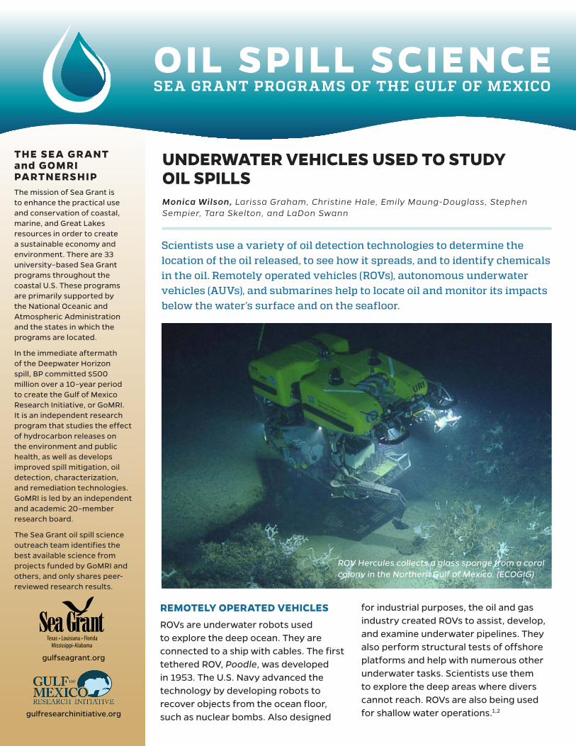
ROV Hercules collects a glass sponge from a coral colony in the Northern Gulf of Mexico. (ECOGIG)
2
FIGURE 1. Images of the same coral taken by an ROV show that in November 2010 (a), the coral has some live yellow coral tissue in the middle and lower left portions but is also covered with brown flocculent material. By November 2011 (b), most of the flocculent material was gone and tiny, stinging organisms that looked like feathers or seaweed occupied the skeleton with no living material.8 (Reprinted from Fisher et al., 2014)
How do ROVs work?
ROVs are controlled with a joystick onboard a boat. They receive their power and send their data through a tether, a direct hard-wire communication cable between the ROV and those onboard.3 ROVs can be equipped with tools such as cameras, lights, robotic arms, claws, cutting blades, water samplers, and instruments that measure temperature, depth, and salinity. The cameras take still photos and videos of the underwater environment. The robotic arms retrieve small objects, cut lines, or attach hooks to larger objects.3,4
During the Deepwater Horizon (DWH) oil spill, ROVs inspected the rig, treated the underwater oil plume with dispersants, and studied the impacts of the oil on the seafloor environment. On April 22, 2010, ROVs diving near the wellhead – located about a mile below the ocean’s surface – found hydrocarbons leaking from the riser pipe.5 As ROVs explored the pipe and attempted to
activate the blowout preventer, scientists discovered other oil leaks. The ROVs supplied videos of oil exiting the wellhead. They also collected samples of the oil and injected dispersants directly into the oil coming out of the wellhead.5
Scientists used ROVs to examine oil’s impacts on deep-sea coral communities.6,7,8 Approximately six months after the DWH spill, the ROV Jason II’s mounted camera took close-up images of 43 corals approximately seven miles southwest of the wellhead. A manipulator claw and the cutting blade collected samples of coral and the brittle stars attached to them. Scientists used the images and samples to assess the oil’s impact on the corals (Figure 1).8,9
In another study, scientists used ROVs to locate and observe corals in the Gulf of Mexico’s mesophotic
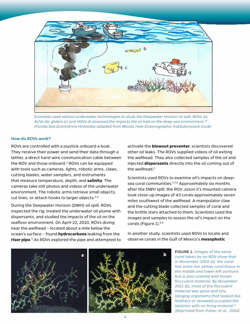
Scientists used various underwater technologies to study the Deepwater Horizon oil spill. ROVs (a), AUVs (b), gliders (c) and HOVs d) assessed the impacts the oil had on the deep-sea environment.24 (Florida Sea Grant/Anna Hinkeldey adapted from Woods Hole Oceanographic Institution/Jack Cook)
a
b
cd
a b
3
zone between 50 and 100 meters’ depth.6,10 Mud samples collected by the ROV showed elevated levels of contaminants on the seafloor.10 Scientists studied images of specific coral locations over time to evaluate their health and condition before and after the DWH oil spill. They found that rates of injury to coral climbed from 4 to 9 percent before the spill to 30 to 50 percent after the spill.6 To learn more about the impacts of oil on the Gulf coral communities, read the Sea Grant publication Corals and oil spills.11
AUTONOMOUS UNDERWATER VEHICLES (AUV)
AUVs are battery-powered, programmable robots that can move or glide through the ocean without an operator. Unlike an ROV, an AUV does not have a cable between it and the research vessel. Similar to ROVs, they conduct underwater missions such as detecting and mapping shipwrecks, studying the depths of the seafloor, and locating obstructions that could be hazardous to vessels.12 AUVs are efficient
and productive because of propulsion and navigation systems that allow them to move independently and accurately in any direction in the water.12 AUVs can also be equipped with a variety of sensors and instruments that provide information and take measurements as they move through the water.12,13 Typical AUV sensors and instruments include the following:
• Side-scan sonar uses soundwaves to create pictures or images of the sea floor.
• Cameras take photographs and videos of the location being surveyed.
• Multibeam sonar uses soundwaves to provide information about the seafloor’s depth.
• Conductivity, temperature, depth (CTD) and water quality sensors measure a variety of water quality properties such as temperature, salinity, depth, pH, and oxygen levels.
• Acoustic Doppler Current Profilers (ADCP) measure the ocean currents.12,13
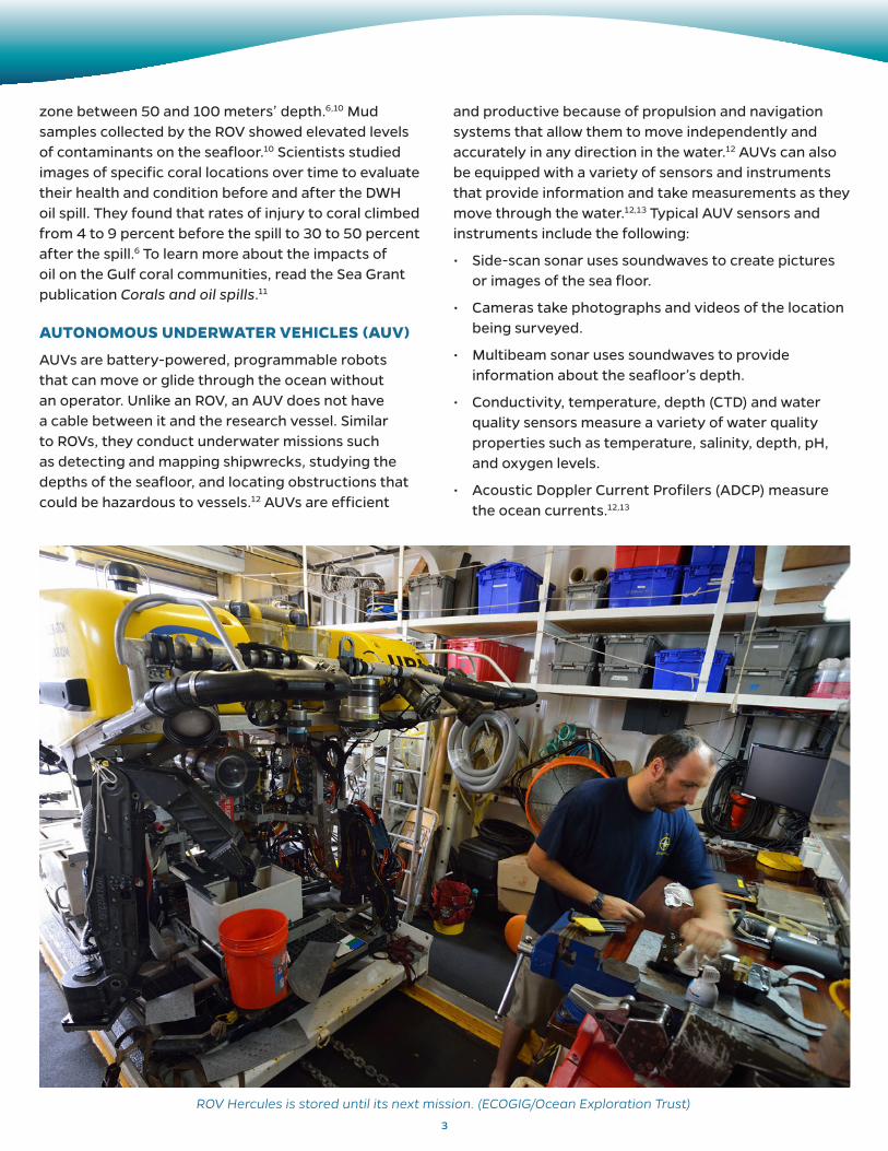
ROV Hercules is stored until its next mission. (ECOGIG/Ocean Exploration Trust)
4
AUVs conduct surveys in an array of depths, from 16 feet to about 20,000 feet below the surface. Scientists plan and download their program to the AUV prior to the launch and deploy the vehicle from the surface to begin its mission. The vehicle returns to the surface to be recovered by a research vessel once its mission is complete or it begins to run out of battery power.12
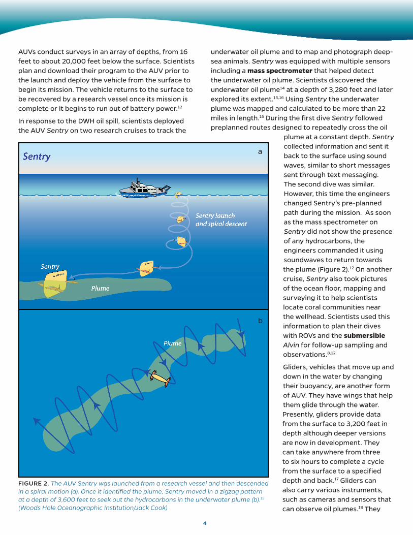
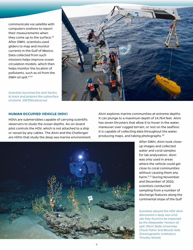
In response to the DWH oil spill, scientists deployed the AUV Sentry on two research cruises to track the
underwater oil plume and to map and photograph deep-sea animals. Sentry was equipped with multiple sensors including a mass spectrometer that helped detect the underwater oil plume. Scientists discovered the underwater oil plume14 at a depth of 3,280 feet and later explored its extent.15,16 Using Sentry the underwater plume was mapped and calculated to be more than 22 miles in length.15 During the first dive Sentry followed preplanned routes designed to repeatedly cross the oil
plume at a constant depth. Sentry collected information and sent it back to the surface using sound waves, similar to short messages sent through text messaging. The second dive was similar. However, this time the engineers changed Sentry’s pre-planned path during the mission. As soon as the mass spectrometer on Sentry did not show the presence of any hydrocarbons, the engineers commanded it using soundwaves to return towards the plume (Figure 2).12 On another cruise, Sentry also took pictures of the ocean floor, mapping and surveying it to help scientists locate coral communities near the wellhead. Scientists used this information to plan their dives with ROVs and the submersible Alvin for follow-up sampling and observations.8,12
Gliders, vehicles that move up and down in the water by changing their buoyancy, are another form of AUV. They have wings that help them glide through the water. Presently, gliders provide data from the surface to 3,200 feet in depth although deeper versions are now in development. They can take anywhere from three to six hours to complete a cycle from the surface to a specified depth and back.17 Gliders can also carry various instruments, such as cameras and sensors that can observe oil plumes.18 They
a
b
FIGURE 2. The AUV Sentry was launched from a research vessel and then descended in a spiral motion (a). Once it identified the plume, Sentry moved in a zigzag pattern at a depth of 3,600 feet to seek out the hydrocarbons in the underwater plume (b).15 (Woods Hole Oceanographic Institution/Jack Cook)
HUMAN OCCUPIED VEHICLE (HOV)
HOVs are submersibles capable of carrying scientific observers to study the ocean depths. An on-board pilot controls the HOV, which is not attached to a ship or vessel by any cables. The Alvin and the Challenger are HOVs that study the deep sea marine environment.
Alvin explores marine communities at extreme depths. It can plunge to a maximum depth of 14,764 feet. Alvin has seven thrusters that allow it to hover in the water, maneuver over rugged terrain, or rest on the seafloor. It is capable of collecting data throughout the water, producing maps, and taking photographs.20
After DWH, Alvin took close-up images and collected water and coral samples for lab analyzation. Alvin was only used in areas where the vehicle could get close to coral communities without causing them any harm.9,12 During November and December of 2010, scientists conducted sampling from a number of discharge features along the continental slope of the Gulf
communicate via satellite with computers onshore to report their measurements when they come up to the surface.19 After DWH, scientists used gliders to map and monitor currents in the Gulf of Mexico. Data collected from such missions helps improve ocean circulation models, which then helps monitor the location of pollutants, such as oil from the DWH oil spill.17,19
5
Scientists aboard the HOV Alvin discovered a deep sea coral site they found to be impacted by the Deepwater Horizon oil spill. (Penn State University/Chuck Fisher and Woods Hole Oceanographic Institution/Timothy Shank)
Scientists launched the AUV Sentry to track and pinpoint the subsurface oil plume. (OET/NautilusLive)
6
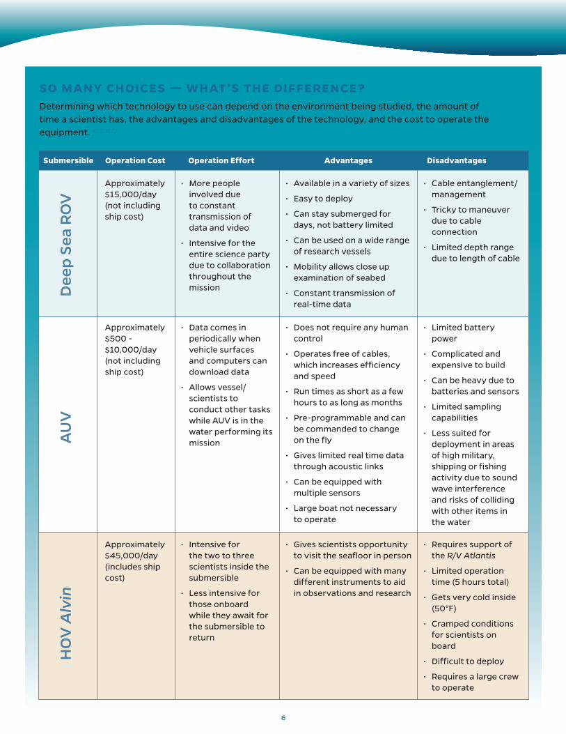
Submersible Operation Cost Operation Effort Advantages Disadvantages
SO MANY CHOICES — WHAT’S THE DIFFERENCE?Determining which technology to use can depend on the environment being studied, the amount of time a scientist has, the advantages and disadvantages of the technology, and the cost to operate the equipment. 4,13,22,23
Approximately $15,000/day (not including ship cost)
Approximately $500 - $10,000/day (not including ship cost)
Approximately $45,000/day (includes ship cost)
• More people involved due to constant transmission of data and video
• Intensive for the entire science party due to collaboration throughout the mission
• Data comes in periodically when vehicle surfaces and computers can download data
• Allows vessel/scientists to conduct other tasks while AUV is in the water performing its mission
• Intensive for the two to three scientists inside the submersible
• Less intensive for those onboard while they await for the submersible to return
• Available in a variety of sizes
• Easy to deploy
• Can stay submerged for days, not battery limited
• Can be used on a wide range of research vessels
• Mobility allows close up examination of seabed
• Constant transmission of real-time data
• Does not require any human control
• Operates free of cables, which increases efficiency and speed
• Run times as short as a few hours to as long as months
• Pre-programmable and can be commanded to change on the fly
• Gives limited real time data through acoustic links
• Can be equipped with multiple sensors
• Large boat not necessary to operate
• Gives scientists opportunity to visit the seafloor in person
• Can be equipped with many different instruments to aid in observations and research
• Cable entanglement/management
• Tricky to maneuver due to cable connection
• Limited depth range due to length of cable
• Limited battery power
• Complicated and expensive to build
• Can be heavy due to batteries and sensors
• Limited sampling capabilities
• Less suited for deployment in areas of high military, shipping or fishing activity due to sound wave interference and risks of colliding with other items in the water
• Requires support of the R/V Atlantis
• Limited operation time (5 hours total)
• Gets very cold inside (50°F)
• Cramped conditions for scientists on board
• Difficult to deploy
• Requires a large crew to operate
Dee
p S
ea R
OV
AU
VH
OV
Alv
in
7
REFERENCES
1. Poore, K., Kitts, C., Wheat, G., & Kirkwood, W. (2016). A small scale ROV for shallow-water science operations. Proceedings of the Oceans 2016 MTS/IEEE, Monterey, CA, 1-6.
2. Pacunski, R. E., Palsson, W. A., Green, H. G., & Gunderson, D. (2008). Conducting visual surveys with a small ROV in shallow water. In J. R. Reynolds & H. G. Greene (Eds.), Marine Habitat Mapping Technology for Alaska (109-128). Fairbanks: Alaska Sea Grant College Program.
3. Christ, R. D., & Wernli, R. L. (2014). The ROV Manual (Second Edition): A user guide for remotely operated vehicles. ISBN: 978-0-08-098288-5.
GLOSSARY
Blowout preventer — A large valve used to seal, control, and monitor oil and gas wells to prevent the well from releasing oil or gas.
Dispersants — Chemicals that are used during oil spill response efforts to break up oil slicks and limit floating oil from impacting sensitive ecosystems such as coastal habitats.
Hydrocarbons — Compounds composed of carbon and hydrogen atoms. Most hydrocarbons naturally occur in crude oil and natural gas and are formed from decomposed organic matter.
Mass spectrometer — An instrument used to identify the kinds of chemical particles present in a substance.
Mesophotic — A low light environment at depths of 100 to 500 feet below the ocean’s surface.
pH — A measure of the acidity or alkalinity of a solution.
Riser pipe — A pipe that connects the oil platform to an underwater oil well.
Salinity — The average concentration of dissolved salts in a body of water.
Submersible — A small vehicle designed to operate underwater.
of Mexico. While aboard Alvin, they witnessed natural oil seeps in the Gulf, observing gas and oil seepages as rising bubbles. They used Alvin to collect sediment cores at the bottom of the Gulf of Mexico and water samples from active gas seeps to test for radium isotopes, which can serve as tracers to detect oil in the environment.21
Technology played a large role in studying the DWH oil spill and this publication only featured a small subset of the breadth of technology used. It is always evolving and scientists are constantly finding new ways to use technology in their research. The Gulf of Mexico Research Initiative (GoMRI) funds these ongoing studies. Emerging information can be found on GoMRI’s website
at http://gulfresearchinitiative.org. To access other oil spill-related publications or view the references in this publication on Sea Grant Oil Spill Science Outreach Program website: www.gulfseagrant.org/oilspilloutreach.
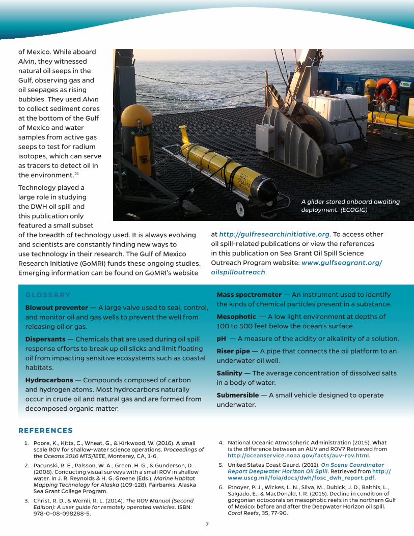
A glider stored onboard awaiting deployment. (ECOGIG)
4. National Oceanic Atmospheric Administration (2015). What is the difference between an AUV and ROV? Retrieved from http://oceanservice.noaa.gov/facts/auv-rov.html.
5. United States Coast Gaurd. (2011). On Scene Coordinator Report Deepwater Horizon Oil Spill. Retrieved from http://www.uscg.mil/foia/docs/dwh/fosc_dwh_report.pdf.
6. Etnoyer, P. J., Wickes, L. N., Silva, M., Dubick, J. D., Balthis, L., Salgado, E., & MacDonald, I. R. (2016). Decline in condition of gorgonian octocorals on mesophotic reefs in the northern Gulf of Mexico: before and after the Deepwater Horizon oil spill. Coral Reefs, 35, 77-90.
This work was made possible in part by a grant from The Gulf of Mexico Research Initiative, and in part by the Sea Grant programs of Texas, Louisiana, Florida and Mississippi-Alabama. The statements, findings, conclusions and recommendations do not necessarily reflect the views of these organizations.
GOMSG-G-18-005
Texas • Louisiana • Florida Mississippi-Alabama
SUGGESTED CITATION:
Wilson, M., Graham, L., Hale, C., Maung-Douglass, E., Sempier, S., Skelton, T., and Swann, L. (2017). Underwater vehicles used to study oil spills. GOMSG-G-18-005.
OIL SPILL SCIENCE OUTREACH TEAM
Christine Hale Texas Sea Grant College Program
Emily Maung-Douglass Louisiana Sea Grant College Program
Stephen Sempier Mississippi-Alabama Sea Grant Consortium
Tara SkeltonMississippi-Alabama Sea Grant Consortium
LaDon Swann Mississippi-Alabama Sea Grant Consortium
Monica Wilson Florida Sea Grant, UF/IFAS Extension
7. Hsing, P.-Y., Fu, B., Larcom, E. A., Berlet, S. P., Shank, T. M., Frese Govindarajan, A., . . . Fisher, C. R. (2013). Evidence of lasting impact of the Deepwater Horizon oil spill on a deep Gulf of Mexico coral community. Elementa Science of the Anthro-pocene 1(12).
8. Fisher, C. R., Demopoulos, A. W. J., Cordes, E. E., Baums, I. B., White, H. K., & Bourque, J. R. (2014). Coral communities as indi-cators of ecosystem-level impacts of the Deepwater Horizon spill. BioScience, 64(9), 796-807.
9. White, H. K., Hsing, P., Cho, W., Shank, T. M., Cordes, E. E., Quattrini, A. M., . . . Fisher, C. R. (2012). Impact of the Deepwa-ter Horizon oil spill on deep-water coral community in the Gulf of Mexico. Proceedings of the National Academy of Sciences, 109(50), 20,303-20,308.
10. Silva, M., Etnoyer, P. J., & MacDonald, I. R. (2016). Coral injuries observed at mesophotic reefs after the Deepwater Horizon oil discharge. Deep Sea Research Part II: Topical Studies in Oceanography, 129, 96-107.
11. Hale, C., Graham, L., Maung-Douglass, E., Sempier, S., Skel-ton, T., Swann, L., & Wilson, M. (2017). Corals and oil spills. TAMU-SG-17-505.
12. Kinsey, J. C, Yoerger, D. R., Jakuba, M. V., Camilli, R., Fisher, C. R., & German, C. R. (2011). Assessing the Deepwater Horizon oil spill with the Sentry autonomous underwater vehicle. Proceedings of the 2011 IEEE/RSJ International Conference on Intelligent Robots and Systems (IROS), San Francisco, CA, 261-267.
13. Wynn, R. B., Huvenne, V. A. I., Le Bas, T. P., Murton, B. J., Connelly, D. P., Bett, B. J., . . . Hunt, J. E. (2014). Autonomous underwater vehicles (AUVs): Their past, present and future contributions to the advancement of marine geoscience. Marine Geology, 352, 451-468.
14. Dierks, A. –R., Highsmith, R. C., Asper, V. L., Joung, D., Zhou, Z., Guo, L., . . . Lohrenz, S. E. (2010). Characterization of sub-surface polycyclic aromatic hydrocarbons at the Deepwater Horizon site. Geophysical Research Letters, 37(30), L20602.
15. Camilli, R., Reddy, C. M., Yoerger, D. R., Van Mooy, B. A. S., Jakuba, M. V., Kinsey, J. C., . . . Maloney, J. V. (2010). Tracking hydrocarbon plume transport and biodegradation at Deepwa-ter Horizon. Science, 330(6001), 201-204.
16. Ready, C., M., Arey, J. S., Seewald, J. S., Sylva, S. P., Lemkau, K. L., Nelson, R. K., . . . Camilli, R. (2012). Composition and fate of gas and oil released to the water column during the Deepwater Horizon oil spill. Proceedings of the National Academy of Sciences, 109(50), 20,229-20,234.
17. Rudnick, D. L., Baltes, R., Lembke, C., Crowley, M., Schofield, O., & Lee, C. M. (2012). A national glider network for sustained observation of the coastal ocean. Oceans, Hampton Roads, VA, 1-5.
18. Klemas, V. (2010). Tracking oil slicks and predicting their trajectories using remote sensors and models: case studies of the Sea Princess and Deepwater Horizon oil spills. Journal of Coastal Research, 26(5), 789-797.
19. Liang, X., Wu, W., Chang, D., & Zhang, F. (2012). Real-time mod-elling of tidal current for navigating underwater glider sensing networks. Procedia Computer Science, 10, 1,121-1,126.
20. Woods Hole Oceanographic Institution (2017). Human occu-pied vehicle Alvin. Retrieved from http://www.whoi.edu/main/hov-alvin.
21. Peterson, R. N., Viso, R. F., MacDonald, I. R., & Joye, S. B. (2013). On the utility of radium isotopes as tracers fo hydrocarbon discharge. Marine Chemistry, 156, 98-107.
22. Azis, F. A., Aras, M. S. M., Rashid, M. Z. A., Othman, M. N., & Abdullah, S. S. (2012). Problem identification for underwater remotely operated vehicle (ROV): A case study. Procedia Engineering, 41, 554-560.
23. Yoerger, D. R., Bradley, A. M., Jakuba, M., German, C. R., Shank, T., & Tivey, M. (2007). Autonomous and remotely operated vehicle technology for hydrothermal vent discovery, explora-tion, and sampling. Oceanography, 20(1), 152-161.
24. White, H. K., Conmy, R. N., MacDonald, I. R., & Reddy, C. M. (2016). Methods of oil detection in response to the Deepwater Horizon oil spill. Oceanography, 29(3), 76-87.