Embed Size (px)
Citation preview
Digital Presentation and Preservation of Cultural and Scientific Heritage. Conference Proceedings. Vol. 10, Sofia, Bulgaria: Institute of Mathematics and Informatics – BAS, 2020. ISSN: 1314-4006, eISSN: 2535-0366
Unravelling Landscape Permanencies: A Digital Historical Journey into the Milanese Countryside
Paola Branduini1, Mattia Previtali1, Marco Quaggiotto2, Monica Resmini3
1 ABC Department, Politecnico of Milan, Via Ponzio 31, Milan, Italy 2 DESIGN department, Politecnico of Milan, Via Giovanni Durando 38/A, Milan, Italy
3 DASTU Department, Politecnico of Milan, Via Edoardo Bonardi 3, Milan, Italy [email protected], [email protected], [email protected], [email protected]
Abstract. The objective of the applied research is the construction of a cross-media map to discover the agricultural landscape, through the digitization and geo-referencing on Google maps of historical maps and photos of the Cà Granda Foundation Archive. It allows the visualization and immediate accessibility of landscape transformations, in a sort of multimedia journey through time.
Keywords: Landscape, Geo-reference, Digital Mapping, Cultural Heritage, In-teractive Device.
1 Introduction
In the enhancement and transmission of cultural heritage, we remarked a lack of knowledge on the historical sources and a difficulty in accessing them, due to the defi-ciency of useful tools for their retrieval and a significant absence of digital reproduc-tions. Only in few cases, the institutions in charge to safeguard historical documents digitize them. Often, the digital reproduction concerns few funds, resulting therefore incomplete and transferred to different supports (single databases). This restricts the remote accessing to the vast and varied documentary heritage, a fundamental tool for historical analysis aimed at understanding a territory and its cultural values (Turri, 2002 and 2003). Only through historical documentation, it is possible to outline the narrative of the transformations occurred over the centuries and the causes that generated them. Maps and drawings have the power to return immediately the image of a landscape, as they have recorded their physical structure at various historical thresholds, for different reasons and with different degrees of fidelity. However, these products, as interesting as they are fascinating, if taken alone, are not able to tell how things really went; the "voice" of other documents such as photos, travel reports, oral testimonies, should ac-companied them (Turri 2000). In various cases, the contextual use of these materials has highlighted multiple economic, political, cultural and urban planning situations taken up in specific historical moments (Pagani, 2000). In this context, the emergence of digital cartographic platforms goes beyond their role as tools for consulting archives
120
of geolocated historical documents (Petrescu, 2007), but also constitutes the proposal of narrative forms capable of keeping content and documents in the same heterogene-ous discourse (Thomas, 2013). Documents and materials with different shapes, which refer to different periods, mix the physical territory with the one narrated to create a hybrid space (Soja 1996), cultural and material at the same time.
Experts, like architects, urban planners, geographers, archaeologists, approach the study on the historical evolution of the landscape from different points of view. Ac-cording to the broad definition of landscape done by the European Landscape Conven-tion (COE, 2000) and the need of participation in the value of the cultural heritage provided by the Faro Convention (2005), raising awareness among populations has be-come a priority factor. Awareness embraces all landscapes: urban, rural and periurban, exceptional, ordinary, in good and degraded condition. It involves a large audience, local inhabitant as an occasional visitor, to different age groups and cultural interests. Learning phase can take place in multiple ways, experiential and intellectual, in situ or remotely, individually and in groups, through a walk as well as through a website. Sen-sitize to the landscape encompasses both the sensory and emotional perception of the current state of places but also tries to understand the profound reasons for the trans-formations stratified in the landscape. These two acts are closely related. In the land-scape, man is actor through his own design and cultural action and, at the same time, spectator who observes and understands the meaning of his work. The landscape we see is the result of complex stratigraphy: its design, construction, sedimentation and revision processes continually question the relationship of a population with a place and require to rethink constantly on the values that determine the sense of collective identity (Branduini et Al. 2017).
Concerning the digital transmission from expert to widespread knowledge, we in-quired what methods of communication and representation to adopt in order to impress the complexity of the landscape in the public's memory. We variously attempted strat-igraphic visualizations for the control of transformations in the landscape, such as se-quences of historical maps, aerial views, axonometric cross-sections or bloc diagrams and landscape maps for the tourist. We were searching for a dynamic multimedia vis-ualization involving the listener and guiding him in reading the historical reports of the landscape. The PaRID lab (research and international documentation for landscape) of the Politecnico di Milano, in collaboration with Gicarus lab (Surveying and Modeling) and DCxT lab (Communication Design for the territory) built the research “Care of the landscape, health for people” in 2016.
2 The Construction of a Cross-media Map
Face to the difficulties exposed, an application was proposed in order to allow the vis-ualization of historical maps by overlapping historical photos and stories in a sort of multimedia time travel. A single device, integrating oral, iconographic and written sources, allowed a much wider sensorial perception of the landscape than just reading on paper: it stimulated and facilitated the access of a vast public to understand the his-
121
torical evolution of the landscape and the meanings of the places attributed by the pop-ulations. The aim of the research was therefore the construction of a cross-media map to discover the farmhouses and the agricultural landscape, in collaboration with the Cà Granda Foundation archive.
The targets were twofold. The first was to enhance the agricultural landscape as a cultural heritage and as a complex system of physical, social, economic, symbolic re-lationships built over time. The second was to develop an innovative method for read-ing the landscape stratigraphy, through multimedia communication artifacts.
To this end, the research team produced initially a reasoned selection of geo-icono-graphic documents and defined thematic itineraries in the agricultural landscape of the Cà Granda Foundation in Lombardy, in the south of Milan. Then it digitalized and geo-referenced the documents selected. Finally it created a "map-based web platform" for the exploration of routes and places in the Milanese agricultural landscape: the platform was organized by localization markers for accessing textual, documental and visual contents, navigation by titles and contents with simultaneous visualization on a map of the places, direct consultation by thematic areas and maps.
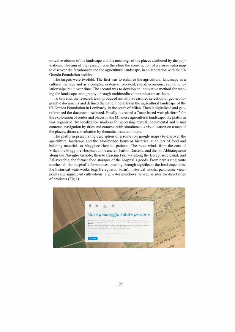
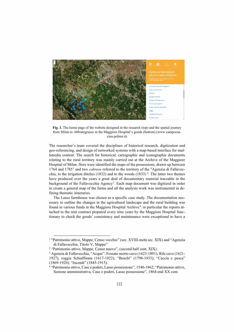
The platform presents the description of a route (on google maps) to discover the agricultural landscape and the Morimondo farms as historical suppliers of food and building materials to Maggiore Hospital patients. The route winds from the core of Milan, the Maggiore Hospital, to the ancient harbor Darsena, and then to Abbiategrasso along the Naviglio Grande, then to Cascina Fornace along the Bereguardo canal, and Fallavecchia, the former food storages of the hospital’s goods. From here a ring route touches all the hospital’s farmhouses, passing through significant the landscape sites: the historical waterworks (e.g. Bereguardo basin), historical woods, panoramic view-points and significant cultivations (e.g. water meadows) as well as sites for direct sales of products (Fig.1).
122
Fig. 1. The home page of the website designed in the research (top) and the spatial journey from Milan to Abbiategrasso in the Maggiore Hospital’s goods (bottom) (www.campocas-
cina.polimi.it)
The researcher’s team covered the disciplines of historical research, digitization and geo-referencing, and design of networked systems with a map-based interface for mul-timedia content. The search for historical, cartographic and iconographic documents relating to the rural territory was mainly carried out at the Archive of the Maggiore Hospital of Milan. Here were identified the maps of the possessions, drawn up between 1764 and 17851 and two cabreos referred to the territory of the "Agenzia di Fallavec-chia, to the irrigation ditches (1832) and to the woods (1833) 2. The latter two themes have produced over the years a great deal of documentary material traceable in the background of the Fallavecchia Agency3. Each map document was digitized in order to create a general map of the farms and all the analysis work was instrumental in de-fining thematic itineraries.
The Lasso farmhouse was chosen as a specific case study. The documentation nec-essary to outline the changes in the agricultural landscape and the rural building was found in various funds in the Maggiore Hospital Archive4: in particular the reports at-tached to the rent contract prepared every nine years by the Maggiore Hospital func-tionary to check the goods’ consistency and maintenance were exceptional to have a
1 “Patrimonio attivo, Mappe, Censo vecchio” (sec. XVIII-metà sec. XIX) and “Agenzia
di Fallavecchia, Titolo V, Mappe” 2 “Patrimonio attivo, Mappe, Censo nuovo”, (second half cent. XIX). 3 Agenzia di Fallavecchia, “Acque”: Fossato morto cavo (1623-1891), Rile cavo (1621-1927), roggia Schiaffinata (1617-1922); “Boschi” (1798-1933); “Caccia e pesca” (1869-1920); “Incendi” (1845-1915). 4 “Patrimonio attivo, Case e poderi, Lasso possessione”, 1540-1862; “Patrimonio attivo,
Sezione amministrativa, Case e poderi, Lasso possessione”, 1864-end XX cent.
123
sort of written landscape postcard. In addition, in order to prepare crops’ maps of dif-ferent ages, the historical land registers5 were consulted at the State Archives of Milan. For the people’s and farmers’ narratives, the Lombard databases on intangible assets were consulted and linked6 (Fig.2).
The maps identified for the analysis area were digitized and geo-referenced in the current cartographic reference system ETRF89 / UTM 32N / WGS 84. The database used for geo-referencing is the official cartography of the Lombardy Region available on the website (https: /www.dati.lombardia.it/). Geo-referencing was performed inde-pendently for each map using a six-parameter affine transformation. The results of the geo-referencing provided, on a series of control points chosen in an appropriate way, residues compatible with a 1: 5.000 scale cartography. The geo-referenced maps were published as map services based on the standard protocols developed by the Open Ge-ospatial Consortium (OGC). In particular, the maps have been published as WMS and WMTS services. The open-source Geo-server server was used to create the map ser-vices. The creation of a suitable series of metadata compatible with INSPIRE regula-tions has also made it possible to create a geo-catalogue through the GeoNetwork open-source platform (GNOS).
The cartographic interface for the contents’ exploration included the design of a plat-form through web technologies (HTML, javascript, CSS), with a "touch" approach to allow use on tablets, dedicated laptops and screens and exploration modes able to take advantage of immersive effects, highlighting models of interaction and web browsing. The platform provided a content management system that allows the insertion of con-tent, their organization into sections, the geolocation of textual and multimedia ele-ments, the management of the cartographic representation and the loading of the con-tent found at the archives, digitized and geo-referred. From a technical point of view, the platform has been developed with web technologies (HTML5, CSS3, Javascript). The cartographic platform uses cartographic libraries (leafletJs) and the maps rely on the MapBox platform for stylization and graphic representation of the territory.
5 Catasto Teresiano, 1722: mappe e registri; Catasto Lombardo-Veneto (Nuovo censo),
1866-1887: mappe e registri; Catasto Cessato, 1897-1901: mappe. 6 REIL, Registro delle Eredità Immateriali Lombarde (https://www.regione.lombar-
dia.it/wps/portal/istituzionale/HP/DettaglioServizio/servizi-e-informazioni/Enti-e-Operatori/Cultura/Beni-culturali/servizio-registro-delle-eredita-Immateriali-regione-+lombardia/registro-eredita-immateriali-lombardia#:~:text=Il%20Re-gistro%20delle%20Eredit%C3%A0%20Immateriali,Storia%20Soci-ale%20di%20Regione%20Lombardia.) “Natura e universo. Imprenditori agricoli e nuovi contadini nel Parco Sud Milano” (http://www.intangible-search.eu/show_ich_detail.php?db_name=intangible_search&lingua=ita-liano&idk=ICH-BPA00-0000000234). LombardiaBeniCulturali, Fotografie, http://www.lombardiabeniculturali.it/fotografie/
124
125
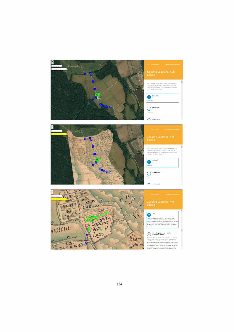
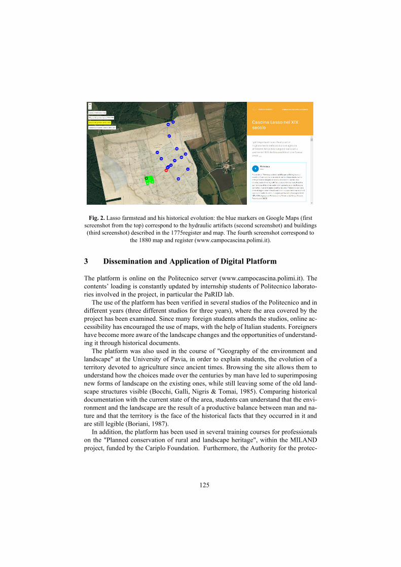
Fig. 2. Lasso farmstead and his historical evolution: the blue markers on Google Maps (first screenshot from the top) correspond to the hydraulic artifacts (second screenshot) and buildings (third screenshot) described in the 1775register and map. The fourth screenshot correspond to
the 1880 map and register (www.campocascina.polimi.it).
3 Dissemination and Application of Digital Platform
The platform is online on the Politecnico server (www.campocascina.polimi.it). The contents’ loading is constantly updated by internship students of Politecnico laborato-ries involved in the project, in particular the PaRID lab.
The use of the platform has been verified in several studios of the Politecnico and in different years (three different studios for three years), where the area covered by the project has been examined. Since many foreign students attends the studios, online ac-cessibility has encouraged the use of maps, with the help of Italian students. Foreigners have become more aware of the landscape changes and the opportunities of understand-ing it through historical documents.
The platform was also used in the course of "Geography of the environment and landscape" at the University of Pavia, in order to explain students, the evolution of a territory devoted to agriculture since ancient times. Browsing the site allows them to understand how the choices made over the centuries by man have led to superimposing new forms of landscape on the existing ones, while still leaving some of the old land-scape structures visible (Bocchi, Galli, Nigris & Tomai, 1985). Comparing historical documentation with the current state of the area, students can understand that the envi-ronment and the landscape are the result of a productive balance between man and na-ture and that the territory is the face of the historical facts that they occurred in it and are still legible (Boriani, 1987).
In addition, the platform has been used in several training courses for professionals on the "Planned conservation of rural and landscape heritage", within the MILAND project, funded by the Cariplo Foundation. Furthermore, the Authority for the protec-
126
tion of historical heritage, the Archaeological, Fine Arts and Landscape Superintend-ence of the Metropolitan City of Milan and the Lombardy Regional Directorate of MI-BACT used it for the evaluation and control of landscape interventions. Finally, the application was presented on several Milanese events that took place in the Bookcity week in 2017.
4 Accessibility and Immediacy in Reading Landscape Transformations
An element of strength of the initiative was the easy access to the historical maps and their immediate readability starting from "a click of the mouse". This allowed profes-sionals to consult rapidly the historical site maps and to check pre-existences for the landscape authorizations. They appreciated the evidence of the historicity of the build-ings and roads around the farmhouses as well as the details of the small agricultural products linked to the farm itself (joints, bridges, manholes).
The public successfully evaluated the website for the possibility of simultaneously viewing past and current maps on their device with great immediacy. This allowed ex-panding the number of historical documents’ users. On the other hand, it was not very useful for the touristic use: viewing the places is difficult since the site structure does not allow continuous movement on the map in space and time at the same time, but only allows the cascade movement within a place (the farmhouse and its fields).
Among the elements of weakness there is also the need for continuous implementa-tion and the scarcity of human resources to devote to this activity (so far we have relied on the work of the trainees, unfortunately discontinuous), as well as the limited cover-age of the maps, since they are concentrated on a small portion of territory (between Abbiategrasso and Fallavecchia).
The experiences conducted and the feedback received from users have shown that the dynamic multimedia display allows you to let the landscape speak for itself, without the need for an oral explanation and a physical presence, but limits the emotional in-volvement of the user. It allows the rapid passage from the past to the present through the immediate overlapping of historical maps, promoting a 'journey through time' in the landscape. It encourages emotional participation through the involvement of multiple senses, even if sight tends to dominate others. It potentially speaks to a wider audience, but must be able to speak different languages simultaneously, with different times and different levels of depth to allow users to memorize concepts. It can constitute a large database, easily updatable as well as a container of visual and sound memories (intan-gible), but it should be frequently updated because communication methods age rap-idly, differently from historical contents. It has the 'gift of ubiquity' and can be acces-sible anywhere: this undoubtedly favors the transmission of knowledge and the diffu-sion of the value of historical knowledge.
Ultimately, the digital visualization helps the understanding of the landscape in a first approach, because it guides the user, or in the consolidation phase of an experience previously occurred. Multimedia promotes involvement and fixation in emotional memory; however, understanding the landscape system and its invisible relationships
127
is a complex concept that requires several stages and levels of study to be fully under-stood and transferred.
5 Conclusions
The applied research "Landscape care, people's health" has achieved several results. Primarily a reasoned selection of geo-iconographic historical documents from the of Maggiore Hospital’s Archive and the identification of thematic itineraries through the Milanese agricultural landscape was attained. Secondly their open publication in the Web by reproduction (georeferencing and vectorization) of textual and cartographic documents was completed. Thirdly, a "map-based web platform" was created for the exploration of routes and places in the Milanese agricultural landscape through locali-zation markers for access to textual, documentary and visual contents related to places, navigation by titles with simultaneous visualization of the places on the map, direct consultation by thematic areas and maps.
The experimentation on the heritage of the Cà Granda Foundation was an oppor-tunity for the creation of a methodological model and technical support extensible to the assets of similar welfare Bodies, owner or manager of agricultural goods, such as ASP Golgi Redaelli, Pio Albergo Trivulzio.
Fundamental criteria were the feasibility and simplicity of implementation and man-agement, in addition to quality. These first assessments are indicative of a success in employing these tools for the transmission of knowledge related to the landscape. Even the systemic conception of the landscape and the understanding of tangible and intan-gible permanencies and their link to everyday life (sensory and symbolic perception of the places), at first more understandable by an adult audience, can be appreciated by a younger audience , through the charming dynamism of multimedia tools and their con-stant use in daily practice. Multimedia tools cannot be a substitute for physical experi-ence, but complementary to it, with synthetic or analytical contents before or after, both for children and adults.
These tools can therefore contribute to the understanding of the landscape and its historical evolution; they can help to recognize oneself in a landscape identity (COE, 2005); they can contribute to raising citizens' awareness and respect for the landscape, both in the short and long term in everyday life (COE, 2000).
The useful and desirable implementations would be the connection with other digit-ization projects to enlarge the digitized territory; the disclosure to local territorial bodies at different scales to verify the landscape insertion of the works; and finally the exten-sion of the digital platform in order to foresee a method of on-site consultation and provide the direct experience of the comparison between the historical territory and its current configuration.
Acknowledgements
The research was funded by Lombardy Region, in the framework of POR FSE Ob. 2 IV axis 2007-2013 program.
128
References
Bocchi, S., Galli, A., Nigris, E. & Tomai, A. (1985). La Pianura Padana. Storia del paesaggio agrario. Milano: CLESAV.
Boriani, M. (1987). L’equilibrio instabile. Problemi di manutenzione e restauro del pae-saggio. In M. Boriani & L. Scazzosi (A cura di), Natura e architettura. La conserva-zione del patrimonio paesistico (pp. 9-18). Milano:Clup
Branduini P., Laviscio R., Colombo F.C., (2017), Landscape maps: knowledge and management tools for cultural heritage in Riva R. (ed.) Ecomuseum and cultural landscapes. State of the art and future prospect, Sant’Arcangelo di Romagna: Mag-gioli editore
Council of Europe, COE (2000), European Landscape Convention, Florence Council of Europe, COE (2005), Convention on the value of cultural heritage, Faro Pagani, L. (2000). Bergamo. Lineamenti e dinamiche della città (pp. 179-265). Ber-
gamo: Edizioni Sestante. Petrescu, F. (2007). The use of GIS technology in cultural heritage. Proceedings of the
XXI International CIPA Symposium, Athens, Greece, 01–06. Sereni, E. (2004). Storia del paesaggio agrario italiano. Roma-Bari: Laterza. Soja, E. W. (1996). Thirdspace: Journeys to Los Angeles and other real-and-imagined
places. Blackwell. Thomas, L. (2013). Cartographic and Literary Intersections: Digital Literary Car-
tographies, Digital Humanities, and Libraries and Archives. Journal of Map & Ge-ography Libraries, 9(3), 335–349. https://doi.org/10/ggzjqj
Turri, E. (2000), Il paesaggio racconta. Reggio Emilia: Fondazione Osvaldo Piacentini, http://www.ocs.polito.it/biblioteca/paesaggio.html
Turri, E. (2002). La conoscenza del territorio. Metodologia per un’analisi storico-geografica. Venezia: Marsilio.
Turri, E. (2003). Il paesaggio degli uomini, la natura, la cultura, la storia. Bologna: Zanichelli.
Received: June 08, 2020 Reviewed: June 19, 2020 Finally Accepted: July 10, 2020