Embed Size (px)
Citation preview
1Up and Down the Hindu Kush
The Hindu Kush rises high above the plains and valleys ofAfghanistan. Over the millennia these majestic mountains havelooked down upon peaceful farmers and wandering pastoralists,upon the armies of Alexander the Great and Chingiz-Khan, upontraders and pilgrims, and in recent years upon multitudes of despar-ate foreign diplomats who have tried to bring peace to this war-torn country. Whatever these men and women accomplished inAfghanistan, not far off there always loomed the towering height ofthe Hindu Kush. Thousands of years ago the ancient Iranians calledthis range the *upâiri saêna, or (kôf-i) apârsên, ‘(the mountains)above the falcon’, or in other words, ‘mountains that rise higher thana bird can fly’.1 In the late first millennium bc, the Greeks corre-spondingly used the name of the Paropanisadae to indicate the plainsthat stretch immediately southeast of the mountains, around themodern capital of Kabul.2 The Classical name probably derives fromIranian *para-upairisaêna, which should mean something like ‘theland which lies beyond the upairisaêna’ and thus indicating a namegiven by people who lived on the other, northern side of the moun-tains. In the early seventh century of the modern era, the ChineseBuddhist pilgrim Xuanzang, while travelling through Afghanistan onhis way from China to the Indian subcontinent and back again, usedthe name of Poluoxina to describe the mountains north of Kabul.3
The appellation recalls the Old Iranian name, and in his Records the
1 The identity of the (Old Iranian, Avestan) Saêna M∂r∂ga (‘Saena bird’, eagle,falcon?) remains unknown. In later Iranian mythology it is referred to as the Simurgh(Middle Persian Sênmurv); compare Bartholomae 1904:398 and Monchi-Zadeh1975:128.2 A western offshoot of the Hindu Kush, north and northeast of Herat, is stillknown as the Paropamisus Range by western geographers.3 Translation of the Si-Yu-Ki, Buddhist Records of the Western World, by SamuelBeal (1884: II, 286).
COPYRIG
HTED M
ATERIAL
pilgrim unwittingly illustrates this point by telling that ‘[t]he verybirds that fly in their wheeling flight cannot mount alone this point,but go afoot across the height and then fly downwards’.
The Hindu Kush is an offshoot of the Himalayas. In its widestsense the name covers much of the rugged centre and northeast ofAfghanistan. The mountains affect the country’s climate, the qualityof its soil, the availability of water and its routes of communication.In this way, the Hindu Kush constitutes a constant factor in the lifeof the people who make a living along its flanks and in the sur-rounding plains. It is a difficult life, in a harsh and often cruel envi-ronment, with cold winters and hot summers. In some areas there is plenty of water, while other places receive hardly any precipitationat all. Sometimes, as at the time of writing this book, it does not rain for years on end, causing immense suffering and great overalldamage. The average life expectancy for Afghan men and women isconsequently very low; the CIA factbook for the year 2000 gives anestimate of 45.88 years.4
Although producing relatively little and forcing people into a con-stant struggle against the environment, the country is also singularlyunique and full of potential, which is mainly due to its geographicalposition. The people of Afghanistan live along one of the most impor-tant high roads of Asia (Ill. 1). Their country constitutes the con-
2 Up and Down the Hindu Kush
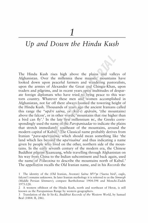
Illustration 1 Group of Afghan Mujahedin, summer 1982 (photograph:author).
4 CIA factbook www.odci.gov/cia/publications/factbook/geos/af.html
necting link between the steppes and deserts of Central Asia, the vastexpanses of the Middle East and Iran, and the lush plains and sweltering heat of the Indian subcontinent. Throughout history,immigrants from neighbouring lands moved into and across themountains and passes of Afghanistan, traversing the country from all sides. They all left their traces, and their descendants, and thuscreated the mosaic of ethnic groups that characterizes the country’spresent population.
Contacts with the outside world, however, were never one-sided.Time and again, the hardened men from Afghanistan moved fromtheir mountains down into the surrounding plains and deserts, forgrazing, trade or plunder. They defeated kingdoms and foundedempires. In this way, the history of the people of Afghanistan is alsothe history of those who live beyond its modern borders.
Against this environmental and geographical backdrop, the peopleof Afghanistan have woven a web of shared customs, beliefs, andtechniques, and with a comparable outlook on life. This web justi-fies the writing of a book on the history of the Afghans as a singlegroup distinct from neighbouring peoples, even if the name ‘Afghan’really only applies to one of the peoples that inhabit the country.These are the Pashtuns, who for centuries have constituted the domi-nant ethnic group of Afghanistan and who live mainly in the southand east of the country and in neighbouring Pakistan. It also meansthat in order to understand the people of Afghanistan and theirhistory, it is necessary to know something about the physical envi-ronment that made the Afghans into what they are now.
Present-day Afghanistan
The modern Islamic State of Afghanistan (Dawlat-i Islâmi-yiAfghânistân)5 is a landlocked country of 647,500 square km (Map1) and is therefore somewhat larger than France.6 In the south andeast, over a distance of 2,430km, it borders on Pakistan. In the north-east, high in the mountains, it shares a very short boundary (76km)with China. Two northern neighbouring countries are Tajikistan(1,206km) and Uzbekistan (137km). In the northwest lies Turk-menistan (744km), and to the west Afghanistan is bounded by theIslamic Republic of Iran (936km). Estimates of Afghanistan’s presentpopulation are notoriously vague. In 1978, experts accepted a figure
Up and Down the Hindu Kush 3
5 The Taliban movement, presently in control of most of the country including thecapital Kabul, describes the country as the Islamic Emirate of Afghanistan.6 CIA factbook.
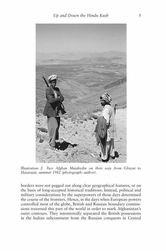
of some fifteen million. Following the communist coup of 27 April1978, and especially after the invasion of the country by Soviet forcesat Christmas 1979, some five million refugees fled the country. Hundreds of thousands died during the war (Ill. 2), which continuedafter the Soviet withdrawal that was completed on 15 February 1989.The number of refugees who have since then returned to their country is unknown, nor are there clear figures of new refugees trying to es-cape the internecine wars that dominate modern politics. The CIAfactbook for 2000 gives estimates of some 1,200,000 Afghans stillremaining in Pakistan, and some 1,400,000 in Iran. Yet what is clear is that in spite of all the upheaval, the population of Afghanistanhas in fact increased considerably and estimates indicate a figure of almost 26 million for mid-2000. However, reliable information and figures are absent and the present description of Afghanistan and its population is therefore mainly based on the pre-1979 situation.
Almost all of the modern frontiers of Afghanistan were formallydefined and acknowledged in the late nineteenth century. Most of the
4 Up and Down the Hindu Kush
TURKMENISTAN^ UZBEKISTAN
IRAN^
Quetta
Ghazni
Qunduz
TermezMarv
Andkhuy
Maymana
Shibarghan^
Farah^
Qal’a-i Bust
Registan Desert^DASHT-I
MARGO
Salang Pass^
Mazar-iSharif
^
NURISTAN^
WAKHAN^
Chitral^
HAZARAJAT^
^
Herat^
Peshawar^
Qandahar^
Kabul^Bamiyan^ ^
BADAKHSHAN^
TAJIKISTAN
SISTAN^
PAKISTAN^ ^
^ ^ ^
Map 1 The main cities and districts of Afghanistan.
borders were not pegged out along clear geographical features, or onthe basis of long-accepted historical traditions. Instead, political andmilitary considerations by the superpowers of those days determinedthe course of the frontiers. Hence, in the days when European powerscontrolled most of the globe, British and Russian boundary commis-sions traversed this part of the world in order to mark Afghanistan’souter contours. They intentionally separated the British possessionsin the Indian subcontinent from the Russian conquests in Central
Up and Down the Hindu Kush 5
Illustration 2 Two Afghan Mujahedin on their way from Ghazni to Hazarajat, summer 1982 (photograph: author).
6 Up and Down the Hindu Kush
Qunduz
Herat^
Kabul^
Qandahar^
Land above 3000 mLand between 1800 and 3000 m
Map 2 The mountains of Afghanistan.
Quetta
Kabul^
Chitral^
Herat^
Qandahar^
Hari Rud
Kokcha R
.
Qun
duz
R.
PanjshirR.
GhorbandR.
Indu
s
Logar Kurram
R.
Gamul R.
Hel
man
d R
.
Khash
R.
Harut
Rud
Amu Darya
Panj
ab^
Kabul R.^
Arghandab^
Tarnak^
Arghasta
n^
Fara
h Rud
^
Murghab^
Amu DaryaPanjab^
IndusBal
khab
R.
^
Peshawar^
Map 3 The main rivers of Afghanistan.
Up and Down the Hindu Kush 7
Asia.7 These were the years of the Great Game between Russia andEngland, so well described by Rudyard Kipling in his book, Kim. Inthose years, the state of Afghanistan under Amir ‘Abd al-RahmanKhan (r. 1880–1901) was eventually acknowledged, not as an inde-pendent country, but as a buffer state within the British sphere of in-fluence. It was formed to prevent any British soldier from directlyfacing his Russian opponent. For this reason, the borders of modernAfghanistan often cut straight through traditional tribal lands. Thisis especially the case in the east, where the lands of the Pashtuns aredivided by the so-called Durand line of 1893.8 Elsewhere, in the south-west, the borderline defined in 1872 and again in 1904,9 splits up anisolated area of potentially fertile lands (Sistan) between Afghanistanand Iran. Only in the northeast does the modern border follow a plaingeographical feature, namely the Panj river (the Panjab) and its con-tinuation, the Amu Darya (the Oxus of Classical authors).10
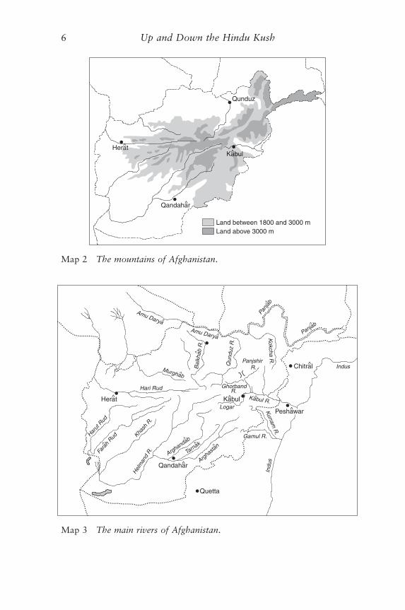
The Hindu Kush Mountains
The Hindu Kush mountains cover most of the northeastern andcentral parts of the country (Map 2). It extends in a southwesterndirection from a mountain knot in the far northeast, where themodern borders of Afghanistan meet those of Tajikistan, China andPakistan. This mountain knot is generally known as the Qara Qorum(Turk. ‘Black Rubble’) and by itself constitutes the most northwest-ern limit of the Himalaya Range. Here the mountains are extremelyhigh, rising to altitudes of over 7,000 metres. Further southwest anddown towards Central Afghanistan the mountains slowly diminish inheight, but the adjoining Kuh-i Baba Range, to the west of the capitalKabul, is still more than 5,000 metres high.11
7 Compare Hungerford Holdich (1901; 1910). Another interesting account is byC. C. Davies 1932. For the so-called Great Game, see especially the books by PeterHopkirk.8 Named after Sir Henry Mortimer Durand (1850–1924), at that time Foreign Sec-
retary of the Government of (British) India (1884–94).9 In September 1904, the Persians and Afghans were made to accept the lines drawn
by Colonel A. H. McMahon. The lines of 1904 mostly follow those of 1872, drawnby General Sir Frederic Goldsmid (see Hamilton 1906). The distribution of the waterof the Hilmand river remained a problem, which was only solved in 1973 with theHilmand Water Treaty, which was ratified by the Afghan government in 1977.10 The Classical name of the Oxus lives on in that of the Wakhsh river, a tributaryof the Panj/Amu Darya. The confluence of these rivers actually marks the place wherethe Panj river changes its name and becomes the Amu Darya. See B. Spuler in theEnc. Isl. (Amu Darya).11 The Shah Fuladi peak rises to a height of 5,158 metres.
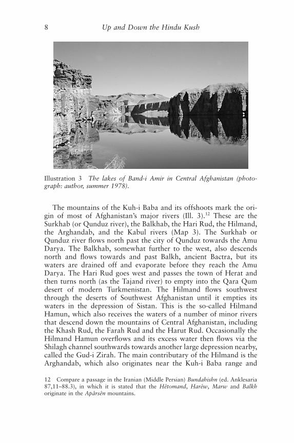
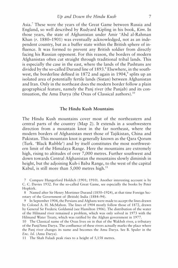
The mountains of the Kuh-i Baba and its offshoots mark the ori-gin of most of Afghanistan’s major rivers (Ill. 3).12 These are theSurkhab (or Qunduz river), the Balkhab, the Hari Rud, the Hilmand,the Arghandab, and the Kabul rivers (Map 3). The Surkhab orQunduz river flows north past the city of Qunduz towards the AmuDarya. The Balkhab, somewhat further to the west, also descendsnorth and flows towards and past Balkh, ancient Bactra, but itswaters are drained off and evaporate before they reach the AmuDarya. The Hari Rud goes west and passes the town of Herat andthen turns north (as the Tajand river) to empty into the Qara Qumdesert of modern Turkmenistan. The Hilmand flows southwestthrough the deserts of Southwest Afghanistan until it empties itswaters in the depression of Sistan. This is the so-called HilmandHamun, which also receives the waters of a number of minor riversthat descend down the mountains of Central Afghanistan, includingthe Khash Rud, the Farah Rud and the Harut Rud. Occasionally theHilmand Hamun overflows and its excess water then flows via theShilagh channel southwards towards another large depression nearby,called the Gud-i Zirah. The main contributary of the Hilmand is theArghandab, which also originates near the Kuh-i Baba range and
8 Up and Down the Hindu Kush
Illustration 3 The lakes of Band-i Amir in Central Afghanistan (photo-graph: author, summer 1978).
12 Compare a passage in the Iranian (Middle Persian) Bundahishn (ed. Anklesaria87,11–88.3), in which it is stated that the Hêtomand, Harêw, Marw and Balkhoriginate in the Apârsên mountains.
flows east of the Hilmand, passes the town of Qandahar (Pashto:Kandahar) in the south of the country and then joins the Hilmand atthe ancient site of (Qal�a-i) Bust. The Kabul river proceeds east, pastthe city of Kabul, and after receiving the waters of a series of tribu-taries flows towards the Indus.
All of these mountains, which separate the north of the countryfrom the south, are generally known, since at least the early four-teenth century, as the Hindu Kush (‘Hindu-killer’). The Moroccantraveller Ibn Battuta (ad 1304–77), who visited this part of the worldin the early 1330s, tells us ‘[t]he mountain is called Hindu Kush,which means “Slayer of Indians”, because the slave boys and girlswho are brought from India die there in large numbers as a result ofthe extreme cold and the quantity of snow’.13
The name of the Hindu Kush, however, should only really beapplied to that part of the mountains that rises immediately north ofKabul. Here the mountain range is at its narrowest and allows fortraffic to proceed via either of a series of passes.14 In fact, the namewas perhaps originally only used for one of these thoroughfares,although we do not know which one. At present, the main pass acrossthe Hindu Kush is the Salang Pass and Tunnel. It directly connectsthe north of the country with the south and the country’s capital,Kabul. The modern road crosses the mountains at a height of 3,363metres. Built under Soviet supervision between 1956 and 1964 itreplaced a lengthy and circuitous route west of Kabul via the ShibarPass, close to the Bamiyan Valley.15 Another, but at present much lessfrequented route between north and south leads east of the Salang,through the Panjshir valley.16
Up and Down the Hindu Kush 9
13 Ibn Battuta III 84. Translation by Routledge 1929:178. The name may also bea corruption of Hindu Kuh (Mountain of Hindu). Compare Dupree 1980:1.14 Compare Grötzbach 1990:240–141. Babur, the Mughal conqueror of India inthe early sixteenth century, lists seven passes of the Hindu Kush (Bâburnâme, trans.by Beveridge 1922:204–5).15 Traditionally there were two main routes from Kabul to Bamiyan. The first goesnorth from Kabul and turns to the west along the Ghorband river and crosses theShibar Pass (2,987m). The other route leads west from Kabul and crosses two passes,namely the Unay Pass (3,354m) and the Hajigak (3,567m) or Iraq Pass (3,963m).From the Bamiyan valley, the ancient road proceeds north via the Aq Ribat Pass(3,117m) and the Dandan Shikan Pass (2,744m). A modern track, built with the helpof German engineers and opened in 1933, leads north from just west of the ShibarPass, along the Bamiyan river, to Doab-i Mekhzarin and hence down into the plainsof North Afghanistan.16 This route crosses the mountains via the Khawak Pass. Traditionally (butwithout any evidence) this is the route thought to have been followed by Alexanderthe Great in the spring of 329 bc when he led his army from the Kabul valley acrossthe mountains to the north (compare Wood 1997:142–4).
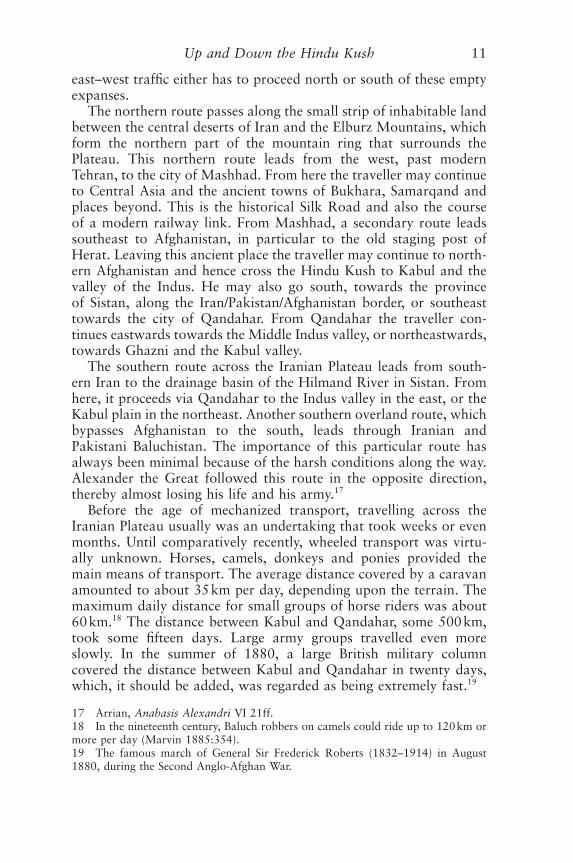
Afghanistan’s Position in Southwest Asia
The modern state of Afghanistan and the adjoining foothills of Pakistan constitute the eastern part of the Iranian Plateau (Map 4).This highland zone extends from the Zagros Range in the west (along the modern Iran–Iraq border) to the banks of the Indus riverin the east. It forms the connecting link between the Near East,Central Asia and the Indian subcontinent and throughout history it has been the thoroughfare for migrants from Central Asia in thenorth to the Near East in the southwest or the Indian subcontinentin the southeast.
The easiest route from the deserts and semi-deserts of SouthCentral Asia onto the Iranian Plateau leads via a gap in the moun-tain chain that bounds the Iranian Plateau in the north. This breaklies between the cities of Mashhad in modern Northeast Iran andHerat in West Afghanistan. The north–south route via the so-calledHerat corridor links up with the two major east–west roads that tra-verse the Plateau. The course of these two routes is determined bythe availability of food and water. Huge deserts, namely the Dasht-iKavir in the north and the adjoining Dasht-i Lut in the south, dominate the centre of modern Iran and the Iranian Plateau. Thesewastelands constitute an enormous barrier and consequently any
10 Up and Down the Hindu Kush
CHINA
AFGHANISTAN
INDIA
NEPAL
0 1000 km
UZBEKISTAN^
KAZAKHSTAN^
TURKMENISTAN^
IRAN^
TAJIKISTAN^ ^
KIRGISTAN^
PAKISTAN
^
^
Map 4 Afghanistan in Southwest Asia.
east–west traffic either has to proceed north or south of these emptyexpanses.
The northern route passes along the small strip of inhabitable landbetween the central deserts of Iran and the Elburz Mountains, whichform the northern part of the mountain ring that surrounds thePlateau. This northern route leads from the west, past modernTehran, to the city of Mashhad. From here the traveller may continueto Central Asia and the ancient towns of Bukhara, Samarqand andplaces beyond. This is the historical Silk Road and also the course of a modern railway link. From Mashhad, a secondary route leadssoutheast to Afghanistan, in particular to the old staging post ofHerat. Leaving this ancient place the traveller may continue to north-ern Afghanistan and hence cross the Hindu Kush to Kabul and thevalley of the Indus. He may also go south, towards the province of Sistan, along the Iran/Pakistan/Afghanistan border, or southeasttowards the city of Qandahar. From Qandahar the traveller con-tinues eastwards towards the Middle Indus valley, or northeastwards,towards Ghazni and the Kabul valley.
The southern route across the Iranian Plateau leads from south-ern Iran to the drainage basin of the Hilmand River in Sistan. Fromhere, it proceeds via Qandahar to the Indus valley in the east, or theKabul plain in the northeast. Another southern overland route, whichbypasses Afghanistan to the south, leads through Iranian and Pakistani Baluchistan. The importance of this particular route hasalways been minimal because of the harsh conditions along the way.Alexander the Great followed this route in the opposite direction,thereby almost losing his life and his army.17
Before the age of mechanized transport, travelling across theIranian Plateau usually was an undertaking that took weeks or evenmonths. Until comparatively recently, wheeled transport was virtu-ally unknown. Horses, camels, donkeys and ponies provided the main means of transport. The average distance covered by a caravanamounted to about 35km per day, depending upon the terrain. Themaximum daily distance for small groups of horse riders was about60km.18 The distance between Kabul and Qandahar, some 500km,took some fifteen days. Large army groups travelled even moreslowly. In the summer of 1880, a large British military columncovered the distance between Kabul and Qandahar in twenty days,which, it should be added, was regarded as being extremely fast.19
Up and Down the Hindu Kush 11
17 Arrian, Anabasis Alexandri VI 21ff.18 In the nineteenth century, Baluch robbers on camels could ride up to 120km ormore per day (Marvin 1885:354).19 The famous march of General Sir Frederick Roberts (1832–1914) in August1880, during the Second Anglo-Afghan War.

The Natural Environment
Afghanistan forms part of an arid, semi-desert belt of lands thatextends across much of the Iranian Plateau.20 Dry, hot summers andcold winters with much snow are permanent features. In the winter,snow covers most of the mountains from about 1,800 metres up-wards. In March the snow begins to melt and the rivers rise. Therivers in Afghanistan therefore carry the maximum amount of waterduring the spring, causing occasional floodings. Apart from theseconstant features, the climatic variations in Afghanistan are enor-mous, not in the least because the north of the country lies open tothe cold winds from Central Asia, while the lands southeast of themountains are affected by the Indian monsoon. Precipitation rangesfrom an annual average of 75mm in the extremely dry southwest ofthe country to 213mm in Mazar-i Sharif (the main city of NorthAfghanistan), 328mm in the eastern town of Ghazni, and an exces-sive 1,150mm high up in the Salang Pass.21
The vegetation of the country is equally diverse. In the east, aroundthe modern town of Jalalabad at an altitude of 552 metres, the vegetation is subtropical, even allowing for some palm trees. Some100km to the west, much higher up along the Kabul valley but stillsouth of the Hindu Kush mountains, vegetation is very different.Kabul itself lies at an altitude of 1,803 metres and here the treesinclude the oak, walnut, alder, ash and juniper. North of the moun-tains, the sand and loess covered lands support steppe vegetation and,if properly watered, yield rich agricultural crops. In South and WestAfghanistan vegetation is minimal. Here the landscape is dominatedby the so-called dasht, the stony desert which is typical for much ofthe Iranian Plateau,22 or by sandy wastes (the reg), as for instance theRegistan desert of South Afghanistan.23
Forests used to be found in the extreme east of the country, alongthe borders with Pakistan, but recent unchecked deforestation haschanged all this. The forests of the Panjshir valley, still known in theMiddle Ages, have also disappeared. Large forests can still be foundin the more secluded districts of Nuristan, northeast of modernKabul.
12 Up and Down the Hindu Kush
20 For the climate and vegetation of Afghanistan, see Dupree 1980:3ff.; Humlum1959; Kraus 1975:32ff.21 Compare Rathjens 1975:41.22 Defined by Fisher 1968:93 as: ‘relatively firm and dry desert, composed of gen-erally small and compacted rock fragments: pebbles, flints, or, most often, silts.’23 A rig or reg refers to finer deposits, usually of sand, which may be in regulardune formation or irregularly deposited as a variable sheet (Fisher 1968:93).
Wildlife in Afghanistan is limited.24 Tigers, which used to roam thebanks of the Amu Darya, the shores of the inland lakes of Sistan anduntil very recently the foothills around Jalalabad in the east, have disappeared. So have the lions.25 However, eagles, foxes, gazelles,hyenas, jackalls and wolves can still be found. Wild asses and wildboars were known until very recent times. High up in the QaraQorum and Hindu Kush there are snow leopards, wild goats, as forinstance the markhor and the ibex, and wild sheep (including theargali or Marco Polo sheep).
Throughout history, Afghanistan has been a supplier of covetedminerals.26 Famous are the deposits of lapis lazuli (Fârsi: Lâjawardor Lâjward) near Sar-i Sang in the valley of the Kokcha river, in the northeast of the country.27 Recently, lapis lazuli has also beenreported from the Chagai hills west of Quetta along the Afghan/Pakistan border.28 Lapis is found at only a few places on earth, andthe Afghan mines, and in particular those in Badakhshan, seem tohave been exploited from a very early date onwards. From the latefourth millennium bc, this semi-precious stone was exported to thesurrounding lands, as far as Egypt. Equally important are the cop-per deposits at many places in the country, especially in the Logarvalley south of Kabul; at some places southwest of Herat; along theArghandab river north of Qandahar, and near Andarab north of the Panjshir valley. Also important, especially for the production of bronze, are the tin deposits to the southwest of Herat. Gold isfound near Muqqur, northeast of Qandahar, and in the rivers ofBadakhshan. Huge deposits of iron ore are found near the HajigakPass, west of Kabul. The natural gas reserves from near Shibarghanand Sar-i Pul, in the northwest of the country, were exploited sincethe late 1960s for export to the north.
Agriculture and Nomadism
Only about 12 per cent of the total surface of Afghanistan is culti-vated. Of this total, some 20 per cent is suitable for dry farming.
Up and Down the Hindu Kush 13
24 Compare Elphinstone 1815:141–5.25 Marco Polo, ed. Latham 1958:75, refers to their presence in medieval NorthAfghanistan.26 Compare Grötzbach 1990:52–5. The famous Balas rubies, named after the landof Badakhshan, do in fact derive from the neighbouring district of Shughnan, alongthe right bank of the Panj river, outside Afghan Badakhshan (compare Marco Polo,ed. Latham 1958:76).27 Herrmann 1968; Potts 1994:199–208. See also Marco Polo, ed. Latham1958:77.28 Compare Potts 1994:210.
These lands produce mainly wheat and barley.29 The rest of cultivableland must be irrigated. Even considering the fact that the populationof Afghanistan is relatively small, shortage of land is therefore amajor problem. Throughout the country the people have for millen-nia tried to increase the extent of cultivable land by digging canalsand, since the first millennium bc, constructing huge networks ofunderground tunnels, the so-called ka(h)rez or qanât.30
Most of the cultivated land lies in the southeast, in and around the Qandahar oasis; in the east, in the Kabul valley and around Jalalabad; in the north, around Qunduz and Mazar-i Sharif, and inthe west, in the valley of the Hari Rud, around the town of Herat.These are the lands traditionally known for their high agriculturalproduction. In the past, large-scale irrigation networks in Sistan andin the northeast of the country created other centres of human acti-vity, but these have since been destroyed or fallen in disrepair.
Animal husbandry is also widely practised. Sheep, goats andchicken are found in almost every village in the country. The im-mediate neighbourhood of the villages, however, does not alwaysprovide enough food for the animals, and many people move withtheir herds into the mountains for summer pasturage. Some of themlead the life of full-time pastoralists, always on the move with theirherds. Such annual migrations make it possible for the people ofAfghanistan to exploit the pastures high up in the mountains and itis yet another way for the Afghans to increase the produce of theirland.
Each spring, the nomads and semi-nomads move their herds intothe mountains of Central Afghanistan. In the autumn they return to their villages or winter camps. The winter quarters are found inthe arid steppes of the southwest and west; in the plains of NorthAfghanistan; and in the low-lying, warm and monsoon-affected districts along the Pakistan border in the east and southeast of thecountry. In the southwest and west of the country the nomads are predominantly Durrani Pashtuns, although they are joined byPashtun Ghaljis, another Pashtun tribal confederacy, who haveadopted many aspects of the Durranis, and by other ethnic groups,including Baluch and Aymaqs. Those who winter in the north areoften Özbeks and others, including Durrani Pashtuns. The latter arethe descendants of those who were forcibly moved from the south in the late nineteenth century. In the west, the nomads are generallyGhalji Pashtuns.
14 Up and Down the Hindu Kush
29 Dupree 1980:43.30 Qanât is the Arabic name used in Iran and (western) Afghanistan; karez orkahrez is the Pashto word.
In 1979, the number of nomads in Afghanistan was estimated atabout one to two million people.31 Most of these are Pashtuns andBaluch. The nomads and semi-nomads, generally called Kuchi32 inAfghanistan, mostly keep sheep and goats. The produce of theanimals (meat, dairy products, hair and wool) is exchanged or soldin order to purchase grain, vegetables, fruit and other products ofsettled life. In this way, an extensive network of exchange has devel-oped along the routes annually followed by the nomads and semi-nomads. The merchant Powindah (Ghalji) Pashtuns33 used to moveannually from the Afghanistan mountains to the valley of the Indusand hence deep into India. These long-distance migrations werestopped in the early 1960s when the border between Afghanistan andPakistan was closed. In recent decades, migrations inside Afghanistancontinue, although trucks are now often being used to move lifestockand family from one place to the other.
In Afghanistan, the Pashtun and Baluch nomads from the southgenerally live in black goat hair tents, while most of the non-Pashtunnomads and semi-nomads from the north, following a Central Asiantradition, live in yurts.34 These are circular and framed constructionscovered with felt.35 They are portable, normally provided with adomed roof, and are extremely strong. Its basic structure is a latticeframework that constitutes the wall; woolen bands are bound aroundthe wall to keep it together. Their survival into the future is open toquestion, for they are expensive and take much time to set up, andbefore the late 1970s their use in Afghanistan was already dwindling.
Up and Down the Hindu Kush 15
31 Grötzbach 1990:57. For the nomads of Afghanistan, see the many studies byKlaus Ferdinand and by N. and R. Tapper. See also Jentsch 1973, Glatzer 1977 andPedersen 1994.32 The Fârsi word Kuch refers to a wandering tribe (and robbers).33 Powal is the Pashto verb for ‘to graze’. See also Persian puyidan, ‘to wander’,‘to trot.’34 A more precise term is Khergâh (Dari) or Uy (Özbek).35 For these dwellings, see especially the study by Szabo and Barfield 1991.