Embed Size (px)
Citation preview

USE OF ROBOTICS AND AUTOMATION FOR MINERAL PROSPECTING AND EXTRACTION
Joint Conference of UNEXMIN, ¡VAMOS! and RTM Projects
Conference Proceedings
30 January 2018Bled, Slovenia

USE OF ROBOTICS AND AUTOMATION FOR MINERAL PROSPECTING AND EXTRACTION
Joint Conference of UNEXMIN, ¡VAMOS! and RTM Projects
30 January 2018, Bled, Slovenia
Editors: Gorazd Žibret, Manja Žebre
Graphic Design: Manja Žebre
Issued by: UNEXMIN, ¡VAMOS! and RTM Projects
Published by: Geological Survey of Slovenia, Ljubljana, January 2018
Printed by: Tiskarna Oman, Peter Oman s.p.
Copies: 170
Citation: The publication should be cited in the bibliography using doi number as follows:
Žibret G., Žebre M. (eds.): Use of robotics and automation for mineral prospecting and
extraction. Joint Conference of UNEXMIN, ¡VAMOS! and RTM Projects. Conference
Proceedings. Slovenia, Bled, 30 January 2018. doi: 10.5474/9789616498579
Disclaimer: UNEXMIN, iVAMOS! and RTM projects received funding from the European
Union's Horizon 2020 Research and Innovation programme, under the Grant Agreements
number 690008 (UNEXMIN), 642477 (iVAMOS!) and 641989 (RTM). This publication reflects
only organiser’s view and the Commission is not responsible for any use that may be made of
the information it contains. Authors take full responsibility for the content of their
contributions.
CIP - Kataložni zapis o publikaciji Narodna in univerzitetna knjižnica, Ljubljana 007.52:553.7(082) JOINT Conference of UNEXMIN, ¡VAMOS! and RTM Projects (2018 ; Bled) Use of robotics and automation for mineral prospecting and extraction : conference proceedings / Joint Conference of UNEXMIN, ¡VAMOS! and RTM Projects, 30 January 2018 Bled, Slovenia ; [editors Gorazd Žibret, Manja Žebre]. - Ljubljana : Geological Survey of Slovenia, 2018 ISBN 978-961-6498-57-9 1. Gl. stv. nasl. 2. Žibret, Gorazd 293345024
Foreword
Mining plays an important role in the modern world. Without a steady supply of minerals, we
would not be able to build all of the equipment, machines, electronic devices and infrastructure
that we use today. Since recycling cannot fully meet the ever-growing demand for minerals,
mining will also play a crucial role in securing the future supply of minerals. Much of the easily
accessible high-grade mineral deposits have already been depleted. Therefore, mining industry
has two options for the future: either to go big and mine lower-grade deposits, or to extract
mineral raw materials in harsh environments, underwater, or at great depth. Despite upscaling
mineral machinery and mines, operating large extraction sites certainly brings many technical
and environmental challenges. The real challenge facing the minerals industry is how to
automate tasks in mining, to allow economical minerals extraction in environments, which are
currently too dangerous for humans such as: very high or low temperatures, toxic substances,
underwater, unstable environments, or high precision mining of minerals in small spaces.
Such environments limit the possibilities for humans to work, so new automated or remotely
controlled mining machinery will have to be developed and deployed. This is the area where
geology, mining engineering, machine construction, robotics and algorithm developers can
cooperate to revolutionise mining for the future. Core challenges in developing new systems
are connected to energy supply and use, transportation, communications, environmental
awareness systems, big data handling and processing, autonomy and automated decision-
making systems, rock-cutting capability of the machinery, ore transport systems, production
capacity, machine and software maintenance requirements and costs, to name only a few.
Several of the aforementioned challenges will be discussed at the “Use of robotics and
automation for mineral prospecting and extraction” conference, which will be held on 30th
January 2018 in Bled, Slovenia. The event itself provides a platform for geologists, mining
engineers, robotic developers, computer programmers, machinery producers, funding
providers and other relevant stakeholders to meet and discuss the challenges, which need to be
addressed in order to achieve the goal of autonomously operating mines of the future. This
meeting is organised jointly by three international research and innovation projects, namely
iVAMOS!, coordinated by Jenny Rainbird from BMT (UK), UNEXMIN, coordinated by Norbert
Zajzon from the University of Miskolc (Hungary) and RTM, coordinated by Mike Buxton from
TU Delft (Netherlands). All of the projects are funded by the European Commission within the
scope of H2020 Research and Innovation Programme. This proves that the European
Commission already recognised important challenges mining industry will need to face in the
future. Local organisation of the event is provided by the Geological Survey of Slovenia.
The conference organisers and all contributors hope that this conference proceedings will act
as a stone in a mosaic presenting the mine of the future. The event itself is certainly an
opportunity to obtain new knowledge, new ideas, create future cooperation and finally, make
lasting friendships.
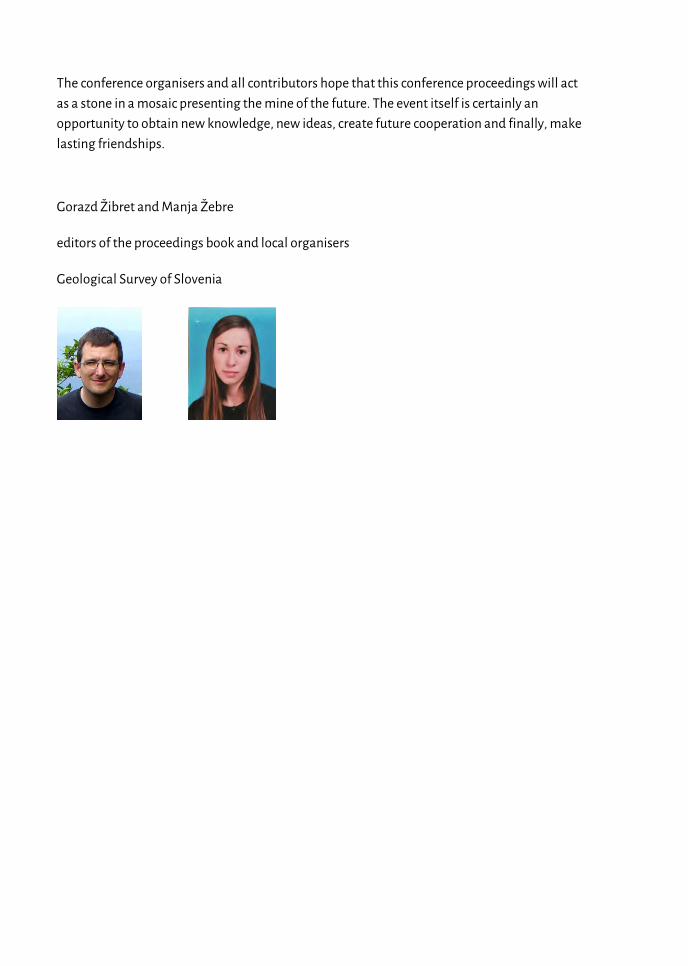
Gorazd Žibret and Manja Žebre
editors of the proceedings book and local organisers
Geological Survey of Slovenia
1
Contents
Organizing Committee ...................................................................................................................... 3
Venue ................................................................................................................................................. 5
Conference Programme .................................................................................................................... 7
Abstracts............................................................................................................................................. 9
Advances in Subsea Mining Stef Kapusniak ............................................................................................................................... 9
Future Mining: Scenarios and Roadmaps (an international review) Marco A. Konrat Martins ................................................................................................................ 11
Robotics in Slovenia Marko Munih ................................................................................................................................. 13
Idrija Mercury Mine, one of the most technologically advanced mines of its time Tatjana Dizdarevič ......................................................................................................................... 15
¡VAMOS! prototype testing Stef Kapusniak .............................................................................................................................. 18
EVA - Exploratory VAMOS AUV José Almeida et al. .......................................................................................................................... 21
Underwater sensors for UNEXMIN to obtain geological and geophysical information Norbert Zajzon et al. ..................................................................................................................... 22
GeoLIBS: Towards real-time ore grading systems in underwater mining applications Pedro Jorge et al. ............................................................................................................................ 24
Latest developments in hard rock continuous mining Uwe Restner .................................................................................................................................. 25
Geological properties of open pit “Smreka” Vares as a pilot site for testing new mine technology Toni Nikolić et al. ........................................................................................................................... 27
Real-time 3D mine model updates in the ¡VAMOS! Project Andreas Nüchter & Michael Bleier ................................................................................................. 29
Defragmentation of information on abandoned underground mines in the framework of the UNEXMIN project Giorgia Stasi & Yves Vanbrabant ................................................................................................... 31
UX-1 Guidance, Navigation and Meta-control Software Zorana Milošević et al. .................................................................................................................... 33
UNEXMIN Post-Processing Software Steve Henley et al. ........................................................................................................................... 35
Use of neural networks for the modelling, classification or categorisation tasks in geo-sciences Gorazd Žibret ................................................................................................................................. 37
2
Co-existence of men and autonomous machinery in confined underground space – need for proximity detection and systems with functional safety Nikolaus A. Sifferlinger .................................................................................................................. 39
The ¡VAMOS! Sustainable Underwater Mining Solution Jenny Rainbird ............................................................................................................................... 41
Real -Time Mining: Sensors for materials characterization Feven Desta et al. ........................................................................................................................... 43
UNEXMIN project: an underwater explorer for flooded mines Luís Lopes ...................................................................................................................................... 46
Workshops ....................................................................................................................................... 49
Workshop 1: Exploitation Workshop.......................................................................................... 49
Workshop 2:Research Roadmapping Workshop ...................................................................... 49
Field Trip Guide ................................................................................................................................. 51
Idrija and its Mercury ................................................................................................................... 51
Anthony's Main Road and Hg Smelting Plant ............................................................................ 51
Attendance List ................................................................................................................................ 53
Learn Slovene in 5 minutes .............................................................................................................. 57
Notes................................................................................................................................................. 59
3
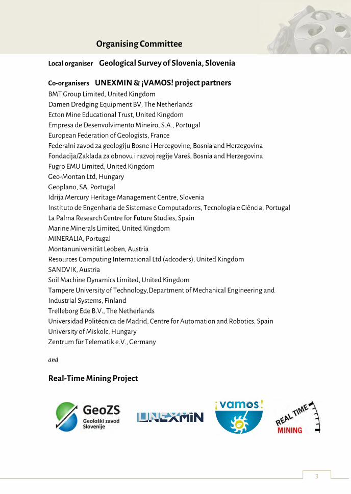
Organising Committee
Local organiser Geological Survey of Slovenia, Slovenia
Co-organisers UNEXMIN & ¡VAMOS! project partners
BMT Group Limited, United Kingdom
Damen Dredging Equipment BV, The Netherlands
Ecton Mine Educational Trust, United Kingdom
Empresa de Desenvolvimento Mineiro, S.A., Portugal
European Federation of Geologists, France
Federalni zavod za geologiju Bosne i Hercegovine, Bosnia and Herzegovina
Fondacija/Zaklada za obnovu i razvoj regije Vareš, Bosnia and Herzegovina
Fugro EMU Limited, United Kingdom
Geo-Montan Ltd, Hungary
Geoplano, SA, Portugal
Idrija Mercury Heritage Management Centre, Slovenia
Instituto de Engenharia de Sistemas e Computadores, Tecnologia e Ciência, Portugal
La Palma Research Centre for Future Studies, Spain
Marine Minerals Limited, United Kingdom
MINERALIA, Portugal
Montanuniversität Leoben, Austria
Resources Computing International Ltd (4dcoders), United Kingdom
SANDVIK, Austria
Soil Machine Dynamics Limited, United Kingdom
Tampere University of Technology,Department of Mechanical Engineering and
Industrial Systems, Finland
Trelleborg Ede B.V., The Netherlands
Universidad Politécnica de Madrid, Centre for Automation and Robotics, Spain
University of Miskolc, Hungary
Zentrum für Telematik e.V., Germany
and
Real-Time Mining Project

4
5
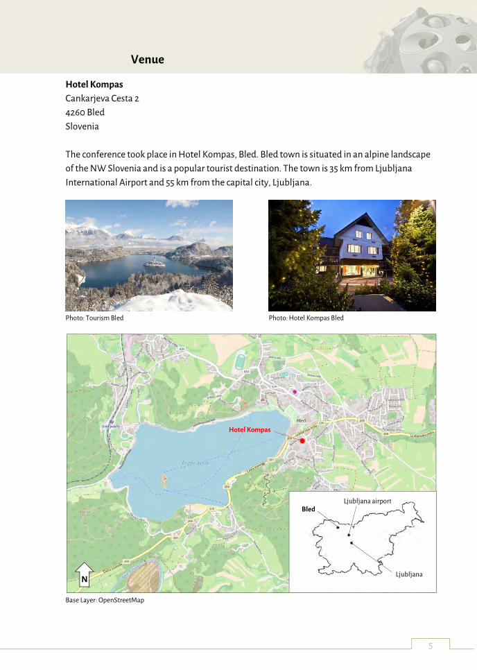
Venue
Hotel Kompas
Cankarjeva Cesta 2
4260 Bled
Slovenia
The conference took place in Hotel Kompas, Bled. Bled town is situated in an alpine landscape
of the NW Slovenia and is a popular tourist destination. The town is 35 km from Ljubljana
International Airport and 55 km from the capital city, Ljubljana.
Photo: Tourism Bled Photo: Hotel Kompas Bled
Base Layer: OpenStreetMap
Ljubljana
Ljubljana airport Bled
Hotel Kompas
N

6
7
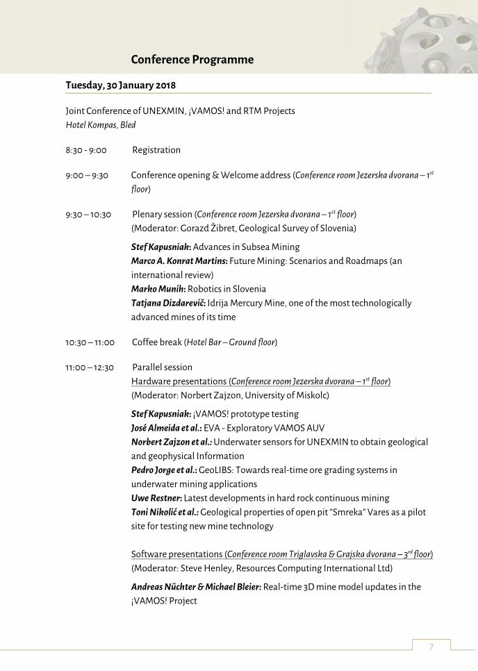
Conference Programme
Tuesday, 30 January 2018
Joint Conference of UNEXMIN, ¡VAMOS! and RTM Projects
Hotel Kompas, Bled
8:30 - 9:00 Registration
9:00 – 9:30 Conference opening & Welcome address (Conference room Jezerska dvorana – 1st
floor)
9:30 – 10:30 Plenary session (Conference room Jezerska dvorana – 1st floor)
(Moderator: Gorazd Žibret, Geological Survey of Slovenia)
Stef Kapusniak: Advances in Subsea Mining
Marco A. Konrat Martins: Future Mining: Scenarios and Roadmaps (an
international review)
Marko Munih: Robotics in Slovenia
Tatjana Dizdarevič: Idrija Mercury Mine, one of the most technologically
advanced mines of its time
10:30 – 11:00 Coffee break (Hotel Bar – Ground floor)
11:00 – 12:30 Parallel session
Hardware presentations (Conference room Jezerska dvorana – 1st floor)
(Moderator: Norbert Zajzon, University of Miskolc)
Stef Kapusniak: ¡VAMOS! prototype testing
José Almeida et al.: EVA - Exploratory VAMOS AUV
Norbert Zajzon et al.: Underwater sensors for UNEXMIN to obtain geological
and geophysical Information
Pedro Jorge et al.: GeoLIBS: Towards real-time ore grading systems in
underwater mining applications
Uwe Restner: Latest developments in hard rock continuous mining
Toni Nikolić et al.: Geological properties of open pit “Smreka” Vares as a pilot
site for testing new mine technology
Software presentations (Conference room Triglavska & Grajska dvorana – 3rd floor)
(Moderator: Steve Henley, Resources Computing International Ltd)
Andreas Nüchter & Michael Bleier: Real-time 3D mine model updates in the
¡VAMOS! Project
8
Giorgia Stasi & Yves Vanbrabant: Defragmentation of information on
abandoned underground mines in the framework of the UNEXMIN project
Zorana Milošević et al.: UX-1 Guidance, Navigation and Meta-control Software
Steve Henley et al.: UNEXMIN Post-Processing Software
Gorazd Žibret: Use of neural networks for the modelling, classification or
categorisation tasks in geo-sciences
Nikolaus A. Sifferlinger: Co-existence of men and autonomous machinery in
confined underground space – need for proximity detection and systems with
functional safety
12:30 – 13:30 Lunch break (Hotel restaurant – Basement floor), invited by La Palma Research
Centre
13:30 – 14:15 Plenary session – projects introduction (Conference room Jezerska dvorana – 1st
floor)
(Moderator: Marko Munih, University of Ljubljana)
Jenny Rainbird: The ¡VAMOS! Sustainable Underwater Mining Solution
Feven Desta et al.: Real -Time Mining: Sensors for materials characterization
Luís Lopes: UNEXMIN project: an underwater explorer for flooded mines
14:15 – 14:45 Coffee break (Hotel bar – Ground floor)
14:45 – 18:00 Parallel workshops
Workshop 1: Exploitation Workshop (Conference room Triglavska & Grajska – 3rd
floor), organised by Geological Survey of Slovenia and BTM Group
Workshop 2: Research Roadmapping Workshop (Conference room Blejska
dvorana – 3rd floor), organised by La Palma Research Centre
19:30 Networking dinner (Hotel restaurant – Basement floor), invited by Geological
Survey of Slovenia
9
Abstracts
Advances in Subsea Mining
Stef Kapusniak
Special Machine Developments, Turbinia Works, Davy Bank, Wallsend, Tyne & Wear, NE28
6UZ, UK
Key words: Subsea, Mining, Technology
The aim of this contribution is to increase awareness in the field of subsea mining. Contrary to
popular belief this is not a new activity. Mankind has been mining subsea for a long time,
starting in ancient Greece. While the activity is not new, initially it was limited to very shallow
water depths. However, technological developments have gradually enabled access to
minerals at greater water depths.
Approximately seventy percent of the earth’s surface is covered by water and it therefore stands
to reason that the vast majority of the earth’s valuable minerals are located underwater. The
subsea resources of most key minerals are relatively untouched, whereas the best easy to mine
land deposits (in terms of low stripping ratio, shallow depth and high grade deposits) have
mainly been exploited. Driving factors for this new industry include…
Increased stripping ratio on land
Decreasing average grade on land of reserves amenable to conventional mining
Increasing population combined with increased per capita requirements for key
minerals
The rise of submersible, remotely controlled equipment
Improvements in robotics
Improvements in underwater navigational techniques
Improvements in submersible grade sensing equipment
Increased exploration and identification of subsea resources
Strategic requirements for specific minerals – similar to those which drove the move
from inland to offshore oil extraction
This presentation focuses on the key emerging and enabling technologies. Advances in wide
area exploration, sampling and reserve definition are highlighted. From an exploitation
perspective examples of relevant equipment from around the world are graphically depicted,
demonstrating how new technologies are opening up more opportunities and how this robotic
and remotely controlled technology is practically deployed in various mineral and geological
settings.
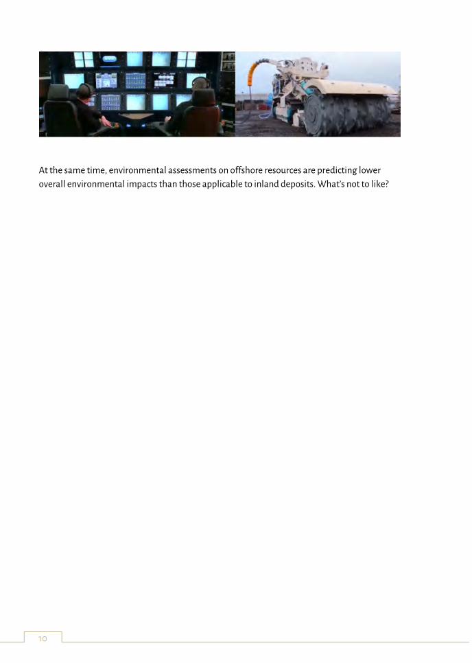
10
At the same time, environmental assessments on offshore resources are predicting lower
overall environmental impacts than those applicable to inland deposits. What’s not to like?
11
Future Mining: Scenarios and Roadmaps (an international review)
Marco A. Konrat Martins La Palma Research Centre, El Frontón 37, 38787 Garafía, Canary Islands, Spain
Key words: foresight, mining, scenario planning, technology roadmapping, future studies
Following the commodity supercycle in the beginning of the 20th century, the mining industry
went through a downturn. An unprecedented uncertainty around the long-term outlook for
the sector started to reveal what is currently seen as a wide range of well recognised challenges.
Notably, but not limited to:
Ability to find new deposits;
Decreasing ore grades;
Increasing mining depths;
Productivity;
Energy cost efficiency;
Geopolitical landscape; and
Social acceptance (Social License to Operate)
The accelerated sectoral complexity in which entities operate open-up a variety of challenges
that put pressure on the sector’s capabilities. The mining activity stretches for long timespans
and its inherent dynamics require forward-looking capacities. Multiple contexts within the
mining sector can benefit from the application of systematic forward-looking approaches.
The author suggests, therefore, that the mining sector needs to consider multiple futures
whenever attempting to look into longer time horizons – which is often the case. Foresight
studies are a systematic attempt to look into the longer-term future of multiple areas and it is
built on the premise of not seeking a deterministic prediction (forecasting), but rather strategic
preparedness and insights provision. It taps into collective knowledge – it is ideally a
participatory process – and aims at informing decision-making at present day.
Most prominently, Scenario Planning and Technology Roadmapping are tools frequently
observed. This study reviewed a wide number of forward-looking publications (40) from
various sources such as academia, government agencies, geological surveys, research
institutions, think thanks and not-for-profit institutions. Those applying scenario planning and
technology roadmapping were reviewed in more detail to understand what these methods
provided to the study.
12
More specifically, Scenario Planning was applied to:
Provide a platform for sectoral futures thinking in a global and national level,
stimulating dialogue and generating tools for decision-making and collaborative
actions;
Support the sectoral transition to a desirable (future) state;
Support policy definition and/or implementation in the sector for a specific area;
Identify main challenges related to the competition for accessing (mineral) resources;
Better integrate geological, technical, economic, environmental, geopolitical and
socio-political factors in minerals exploration management and strategy;
Support the evaluation of mineral projects, capturing externalities and uncertainties
to improve decision-making.
Technology Roadmapping was applied to:
Generate consensus over the future outlook for mining on a national commodity
(copper) level, identifying technological problems and challenges;
Guide national collaborative research activities on exploration & mine planning,
underground mining and surface mining;
Identify future growth opportunities for national Mining Equipment, Technology and
Services (METS) sectors;
“Digital transformation” of mining companies – reshaping companies’ operations
bringing operational technology and information technology together.
They were also observed in combination:
To structure a long-term agenda, linked with the development of a commodity’s (REE)
productive application chains on a national level.
Foresight and its prominent methods – Scenario Planning and Technology Roadmapping – are
increasingly observed in the mining sector, being applied by a wide variety of stakeholders as
well as utilized in multiple contexts. While Roadmapping is more concerned with structuring a
time-based visual depiction of strategy for technological development towards specific targets,
Scenario Planning can provide a platform for dialogue and creative thinking, enhancing
decision-makers capacity to define strategies in a more robust and prepared way.
13
Robotics in Slovenia
Marko Munih
University of Ljubljana, Faculty of Electrical Engineering, Tržaška 25, 1000 Ljubljana, Slovenia
Key words: robotics, university, research, industry, collaborative robot
There are at least three groups of robotic players in Slovenia: university/research, robot
manufactures/integrators and robot users.
Prof. Kralj introduced the doctoral degree robotic lectures at the UL FE back in 1976. In 1978, the
lectures and lab practice in Industrial Robotics as undergraduate course started, soon in 1980,
the first robotic literature was published. UL FE is today conducting the only Master's degree in
robotics in Slovenia. Students have several robotic books available in the Slovene language,
while Slovenian authors also published five textbooks with Springer: Introduction to Robotics,
Robotics, Robot mechanisms, Haptics for virtual reality and teleoperation, Virtual reality
technology and applications. Various robotic courses are today available also to students at UL
FRI, UL FS and UM FERI.
A number of research activities related to robotics are carried out at: UL FE, UL FRI, UL FS, UM
FERI, UM FKBV, very active and recognizable is the ABR department at the IJS, while in the
recent period contributors are also Geological Survey of Slovenia, Soča and TECOS. Research
topics can be divided into four groups: robotic devices, machine vision in robotics, advanced
robotics sensors and human to machine interaction. Further activities relate to lasers,
rehabilitation, sports, complex processing of sensory signals, and, last but not least, agriculture
and mining. Slovenian partners were/are active in more than 55 EU funded FP6, FP7 and H2020
research projects.
The IJS developed for Gorenje company the painting robot Goro 1, it started to work in industry
in year 1980. In the 80s Iskra Kibernetika together with UL FE developed the assembly robot
Roki. In cooperation with Riko, IJS later developed the Riko 106 robot. Today, there are
approximately 2,500 robots working in the Slovenian industry, of which more than 720 in the
Novo mesto area. The number of robots per 10,000 employees in Slovenia is over 100, which is
comparable to the most developed neighbouring countries. A particularly well equipped is
automotive industry, probably the most robotized factory in Slovenia is KLS, which employs
approximately 250 employees and uses the same number of robots.
For Slovenian robotics, are small and medium-sized enterprises very important as
manufacturers of robots and manufacturers of automated industrial robot systems and
equipment. They are renomated domestically and abroad: Yaskawa Slovenia, ABB, Daihen-
Varstroj, Domel (Staubli), Fanuc, INEA (Mitsubishi) DAX (Epson), mCost (UR), Roboteh (KUKA).
Important role are playing also machine and toolmakers: Kolektor Toolbox PC Vision, Kolektor
14
Toolbox PE Automation and Machine Building, Titus +, FeroCrtalič, ETRA, Iskra Mechanisms,
GAIO, Gorenje Toolbox, EM.tronic, Equipments Ravne, EMO Toolbox, ETA Toolbox, ALBATROS
-PRO. Yaskawa is building a new factory of robots in Kočevje, while RLS produces absolute
encoders for UR robots.
Robots are being intalled in the Slovenian industry through different channels, statistics is not
very accurate, except for Novo mesto. The end-users: Revoz, Hella, Odelo, Unior, Petrol, Lek,
Kolektor, TPV, BSH, Titus +, Danfos, Cablex and others have installed minor part of the robot
number with their own staff, major part with the help of domestic integrators or, robots were
obtained through their foreign partners, i.e. from foreign integrators. We estimate that the
number of robotic cells manufactured in Slovenia and sold abroad is notably higher than the
number of cells directly imported to the Slovenian industry. The trends in last period show that
collaborative robots will gain importance. Currently, the TPV company is leading the
cooperative robot number.
15
Idrija Mercury Mine, one of the most technologically advanced mines of its time
Tatjana Dizdarevič
Idrija Mercury Heritage Management Centre, Bazoviška 2, SI - 5280 Idrija, Slovenia
Key words: Idrija, mercury, mining, technological development
Ore mining in Idrija began after native mercury was discovered in 1490. Initial mining efforts
were not very successful. It took years before the miners stumbled upon plentiful lodes (y.
1508), which prompted a flurry of ownership changes. By 1580 all mining operations were taken
over by the Habsburg Monarchy, for which the mine was an important source of income for
years. The mine was for centuries owned and run by the state – Austria, Italy, Germany, France
and Yugoslavia rule until 1991 when the Republic of Slovenia took it over. Mercury production
continued without interruption from 1508 up to 1977 when a big drop (80%) in the price of
mercury happened. Mining became economically unsustainable. Because of the dependence of
inhabitants on the work provided by the mine, a crisis for the local economy was unavoidable.
With knowledge and quick measures Idrija made steps ahead instead of backwards. The
authorities and key stakeholders worked together and handled it well. They took advantage of
the crisis to make an important shift for a better future.
The gradual closure of the mine begun in 1988 and ended in 2009. The Programme to shut
down the Idrija mine was focused on protecting the town’s center and the exceptional cultural
heritage, located directly above the underground mine. Reinforcing works were carried out in
the mine to protect the buildings above the abandoned ore deposit. Groundwater was used to
fill the lower parts of the mine. The upper sections of the deposit, where unique cinnabar ores
are located in situ, are meanwhile preserved through maintaining the level of water below the
IVth level.
After the closure of the mine, the main activities connected to mining was towards
rehabilitation of mining losses, eliminating the effects of mining activities on the health of
former miners and maintaining of the unflooded part of the pit and monitoring of the affected
area of the Idrija Mercury Mine. In 2009 the Slovenian Government decided to liquidate Idrija
Mercury Mine and two years later the Government established the Idrija Mercury Heritage
Management Centre (CUDHg Idrija) in order to preserve a part of mining, technical, natural
heritage and traditions. Since the shutdown works in the mine have been completed, the
company Idrija Mercury Mine ceased to exist in 2017 and its activities passed to CUDHg Idrija.
Role of CUDHg Idrija is to maintain the unflooded part of the mine, to monitor the
consequences of more than 500-years of mining in Idrija as well as to maintain the Idrija
Mercury Mine’s heritage.
16
The area in Idrija is home to various sites where machines and other equipment featuring in the
production of mercury as well as the processing facilities for obtaining pure mercury and
having great importance for the mine and the area as a whole have been kept. Many of them
represent cutting-edge technological achievements, even great inventions, of the time. Today
many of them are considered globally as being among a few or even the only preserved
examples of their kind. While some were obtained through the trade and cooperation that
existed with Spain, others, usually those belonging to the later periods, were products of the
long mining tradition and were linked to the benefits of the trading of mercury route for mine’s
development and status.
The Idrija mercury ore deposit runs along the northwest-southeast trajectory, covering an area
1,500 metres in length and 300-600 metres in width, and reaching a depth of 420 metres. Prior
to the halting of mining operations, the mine had 15 levels at a depth of 383 metres under the
surface. Centuries of exploitation have resulted in mine tunnels spanning 700 kilometres and
during this time 145,700 tons of mercury was produced. Mining, ore extraction, mine water
pumping, transport and ore processing methods developed in parallel. Mine specifics and the
characteristics of the terrain resulted in the use of drift mining with backfilling from the bottom
upwards. This method was used for over 300 years and was later in 90’s of 20th Ct. replaced by
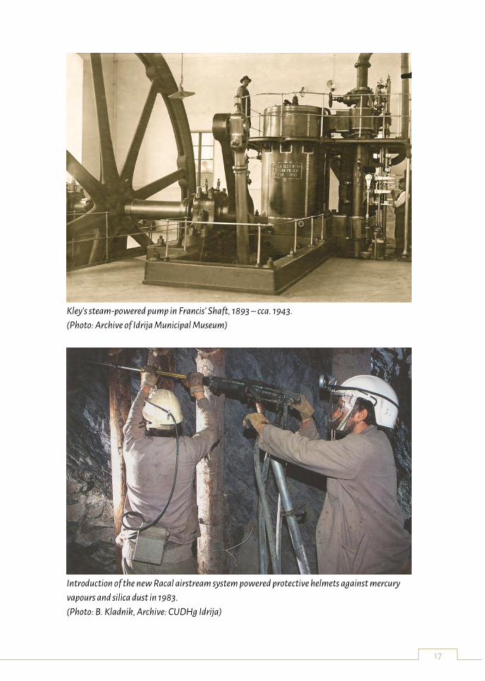
sublevel mining with reinforced backfilling. Innovations from the centuries of mining activities
at the Idrija mine include also the introduction of the water-powered pump – kamšt and the
steam-powered Kley’s pump, which have been preserved. Many other types of preserved
machinery, equipment and technology gives us an insight into the technological development
at the Mine and is in many instances the only example of equipment of its kind to be preserved
anywhere in the world. Generous funding and extensive know-how was poured into research
and modernization of the mine and smeltery in order to maximize production. The Idrija
Mercury Mine would be the training grounds for numerous scientists of international renown.
This ensured that the Mine was at the cutting edge of mining technology, engineering and
smelting in general in Europe, as well as of health, forestry, botany and other sciences.
17
Kley’s steam-powered pump in Francis’ Shaft, 1893 – cca. 1943.
(Photo: Archive of Idrija Municipal Museum)
Introduction of the new Racal airstream system powered protective helmets against mercury
vapours and silica dust in 1983.
(Photo: B. Kladnik, Archive: CUDHg Idrija)
18
¡VAMOS! prototype testing
Stef Kapusniak
Special Machine Developments, Turbinia Works, Davy Bank, Wallsend, Tyne & Wear, NE28
6UZ, UK
Key words: Underwater, Mining, Technology, Inland
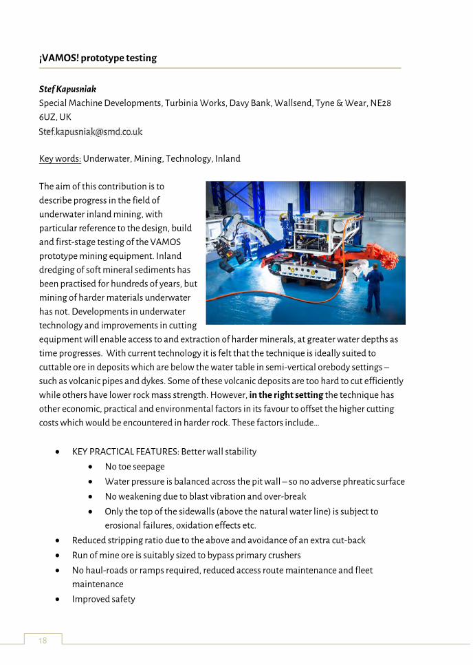
The aim of this contribution is to
describe progress in the field of
underwater inland mining, with
particular reference to the design, build
and first-stage testing of the VAMOS
prototype mining equipment. Inland
dredging of soft mineral sediments has
been practised for hundreds of years, but
mining of harder materials underwater
has not. Developments in underwater
technology and improvements in cutting
equipment will enable access to and extraction of harder minerals, at greater water depths as
time progresses. With current technology it is felt that the technique is ideally suited to
cuttable ore in deposits which are below the water table in semi-vertical orebody settings –
such as volcanic pipes and dykes. Some of these volcanic deposits are too hard to cut efficiently
while others have lower rock mass strength. However, in the right setting the technique has
other economic, practical and environmental factors in its favour to offset the higher cutting
costs which would be encountered in harder rock. These factors include…
KEY PRACTICAL FEATURES: Better wall stability
No toe seepage
Water pressure is balanced across the pit wall – so no adverse phreatic surface
No weakening due to blast vibration and over-break
Only the top of the sidewalls (above the natural water line) is subject to
erosional failures, oxidation effects etc.
Reduced stripping ratio due to the above and avoidance of an extra cut-back
Run of mine ore is suitably sized to bypass primary crushers
No haul-roads or ramps required, reduced access route maintenance and fleet
maintenance
Improved safety
19
Robotic control
No workers in the pit
No blasting misfire risk
Cheaper to pump as opposed to hauling in low stripping ratio mines
Pit is semi-immune from flooding/inrush risk
Equipment can be made in modular format to suit restrictive transport networks
On-site assets can be utilised for longer in the case of pit-extensions
RESOURCE UTILISATION: Improved resource utilisation due to...
Improved safe stripping ratio
Extension of marginally viable pits
Access to hydrologically complex orebodies that are otherwise not viable
Access to buffer zones generally left between operations and towns or
conservation areas
DUST: No dust plumes and subsequent settlement on surrounding neighbours or
environmentally sensitive areas - as this is wet mining
BLASTING: No blasting
No blast fumes
No blast vibration
No blast noise
NOISE: No fleet noise – lower number of machines and machinery noise in dampened
as operations are underwater
DISCHARGE OF MINE-WATER: No mine discharge – water returned to pit to maintain
operability
No turbidity issues downstream
No pollution downstream
No chemical treatment required
REGIONAL DEWATERING: No lowering of local water table
Streams/wells do not dry up
Adjacent wetlands areas are not affected
No lowering of water table below root systems of surrounding forest
No desertification due to drying out of adjacent soils
ENERGY USE: Lower carbon footprint
Lower energy requirements per tonne and lower total tonnes mined due to
stripping ratio advantage
No dewatering or discharge energy or associated chemical treatment
OIL RISK: Small volume of biodegradable oil used compared to conventional
truck/shovel and ancillary fleet. Any leak floats to surface where it can be skimmed off,
rather than disappearing into the ground
20
FUEL RISK: Lower diesel/fuel spillage risk
Lower fuel required
Zero risk from mining equipment if connected to grid, as no fuel used locally
for in-pit mining
Negligible if generator used as fuel would be in a fully contained bund as
opposed to being used in a mobile fleet
VISUAL IMPACT: Lower visual impact of lake versus barren rock
REHABILITATION: Easier, particularly in new pit designed to use underwater mining
Smaller surface footprint of the mining complex (hard-standing areas,
maintenance facilities, road networks)
No surface desertification,
No wetlands/swamp draining
Lower deforestation
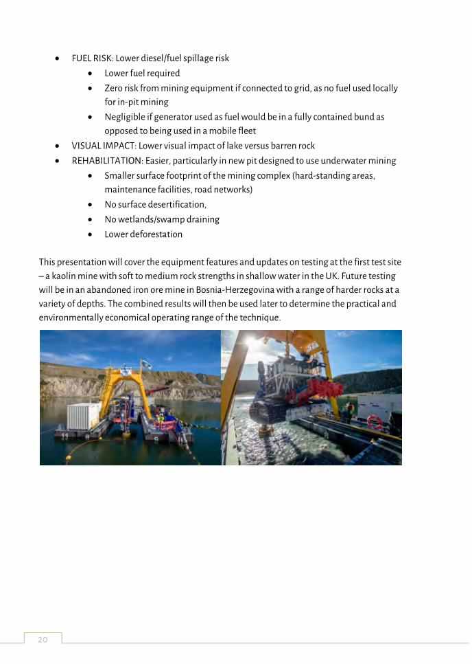
This presentation will cover the equipment features and updates on testing at the first test site
– a kaolin mine with soft to medium rock strengths in shallow water in the UK. Future testing
will be in an abandoned iron ore mine in Bosnia-Herzegovina with a range of harder rocks at a
variety of depths. The combined results will then be used later to determine the practical and
environmentally economical operating range of the technique.
21
EVA - Exploratory VAMOS AUV
José Almeida 1, Alfredo Martins 1, Carlos Almeida 1, André Dias 1, Eduardo Silva 1
(1) INESC TEC, Portugal
EVA is an Autonomous Underwater Vehicle developed for mining exploration assistance. It has
two main tasks: performing accurate realtime 3D mapping of the environment and mining
operation assistance allowing the perception of occluded mine areas and the observation and
navigation of the mining machine. This AUV was developed under the scope of the European
project ¡VAMOS!.
¡VAMOS! will enable access to high grade EU reserves of deeper seated minerals by providing a
new Safe, Clean and Low Visibility Mining Technique and will prove the Environmental and
Economic Viability of extracting currently unreachable mineral deposits, thus encouraging
investment and helping to safeguard the EU access to strategically important minerals. The
¡VAMOS! mining technique will enable: Re-opening abandoned mines; Extensions of opencut
mines which are limited by stripping ratio, hydrological or geotechnical problems; and opening
of new mines with limited environmental impacts in the EU.
22
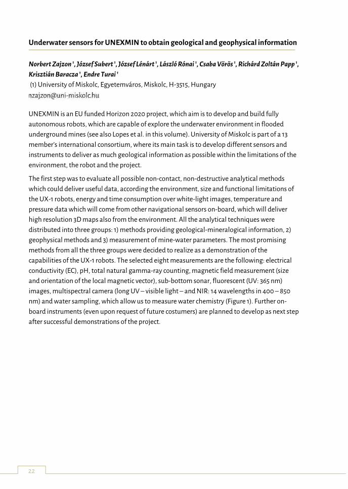
Underwater sensors for UNEXMIN to obtain geological and geophysical information
Norbert Zajzon 1, József Subert 1, József Lénárt 1, László Rónai 1, Csaba Vörös 1, Richárd Zoltán Papp 1,
Krisztián Baracza 1, Endre Turai 1
(1) University of Miskolc, Egyetemváros, Miskolc, H-3515, Hungary
UNEXMIN is an EU funded Horizon 2020 project, which aim is to develop and build fully
autonomous robots, which are capable of explore the underwater environment in flooded
underground mines (see also Lopes et al. in this volume). University of Miskolc is part of a 13
member’s international consortium, where its main task is to develop different sensors and
instruments to deliver as much geological information as possible within the limitations of the
environment, the robot and the project.
The first step was to evaluate all possible non-contact, non-destructive analytical methods
which could deliver useful data, according the environment, size and functional limitations of
the UX-1 robots, energy and time consumption over white-light images, temperature and
pressure data which will come from other navigational sensors on-board, which will deliver
high resolution 3D maps also from the environment. All the analytical techniques were
distributed into three groups: 1) methods providing geological-mineralogical information, 2)
geophysical methods and 3) measurement of mine-water parameters. The most promising
methods from all the three groups were decided to realize as a demonstration of the
capabilities of the UX-1 robots. The selected eight measurements are the following: electrical
conductivity (EC), pH, total natural gamma-ray counting, magnetic field measurement (size
and orientation of the local magnetic vector), sub-bottom sonar, fluorescent (UV: 365 nm)
images, multispectral camera (long UV – visible light – and NIR: 14 wavelengths in 400 – 850
nm) and water sampling, which allow us to measure water chemistry (Figure 1). Further on-
board instruments (even upon request of future costumers) are planned to develop as next step
after successful demonstrations of the project.
23
Figure 1: Selected analytical methods / instruments on-board of the UX-1 robot series.
This project has received funding from the European Union’s Horizon H2020 Research and
Innovation Programme under Grant Agreement No. 690008.
24
GeoLIBS: Towards real-time ore grading systems in underwater mining applications
Pedro Jorge 1, Rui Martins 1, Miguel Ferreira 1
(1) INESC TEC, Portugal
Laser induced breakdown spectroscopy (LIBS) is a powerful technique with the potential to
provide real time identification and quantification of the element composition of unknown
samples by looking at the spectral emission of a laser generated plasma. However, although
conceptually simple and straightforward to implement, it involves complex physics, where the
plasma features depend on the laser parameters, environmental conditions and samples
characteristics. Indeed, the identification and specially the quantification of elements can be
quite challenging, when addressing samples such for eg. complex minerals, where a simple
spectra can have thousands of emission lines, often overlapping, each corresponding to a
specific atomic transition.
In this talk the challenges and opportunities of plasma spectroscopy, as a tool for real
time characterization of complex mineral samples, will be addressed in the context of recent
developments attained in H2020 project VAMOS, field trials in Lee Moor, Devon, UK.
25
Latest developments in hard rock continuous mining
Uwe Restner
Sandvik Mining and Construction G.m.b.H., Alpinestrasse 1, A – 8740 Zeltweg, Austria
Key words: rock cutting, mechanical excavation, continuous mining, hard rock conditions, disk
undercutting technology
The starting point for the development of the MX650 Rapid Mine Development System
(RMDS) was a very clear request by customers simply saying: “Just give me a roadheader, which
can do hard rock cutting.” The currently usually used point attack tool cutting technology
shows clear limitations at ~150MPa UCS in not abrasive and ~70MPa in very abrasive rock
conditions. There might be the potential to slightly increase the area of application of the point
attack tool cutting technology by 10 to 20%, but for real hard rock cutting there is an absolute
requirement for new cutting technologies and new hard rock mining machines. So, Sandvik
finally identified the customer needs of high development speed and of perfect tunnel quality
for initiating the development of the MX650. The target for the MX650 is to smoothly and
accurately excavate and support tunnels from 4 by 4 meters to 5 by 5 meters at a steady
advance rate of 20 meters per day in 150 MPa UCS and very abrasive rock mass conditions. The
key markets for the MX650 – block and panel caving, narrow reef mining, narrow vein mining
and room and pillar mining – show an annual horizontal development need of about 2500
kilometers.
The direct benefit of the use of the MX650 should come from savings in operating costs by less
over-break or over excavation, less footwall preparation, less support installation, less tunnel
maintenance or rehabilitation and less labor due to integrated systems with high degree of
automation. Another and even more significant benefit should be the increase in net present
value (NPV) of ore deposits by quicker delivery of development and earlier start of production,
the lower infrastructure investment cost by lower tunneling operating costs and the higher ore
recovery rate due to better tunnel stability. Especially, in block caving, where the development
speed has a very high influence on the NPV as about 60% of the scheduled activity is just
creating holes in the ground and about 70% of the entire CAPEX is spent prior to any revenue
generation, we see the biggest benefit of the application of the MX650.
The new product development process of the MX650 included the exploration of different
cutting technologies as mini disc cutting, activated pick cutting, low speed pick cutting (still
used on Sandvik’s heavy weight roadheaders), disc undercutting and high speed pick cutting.
Finally, Sandvik decided to go for the disc undercutting technology, which results in lower
normal forces and lower specific cutting energy and enables to develop smarter mining
machines with higher flexibility, which is more suitable to the hard rock mining industry.
26
Especially for the further development of the disc undercutting technology Sandvik invested 5
million euros into a new high load rock cutting test rig.
The assembly and functional testing of the MX650 was completed beginning 2017 and now the
machine is in a trial operation (factory acceptance test – FAT) at Wolfram’s tungsten mine in
Mittersill, Austria. The FAT of the MX650 runs within an EIT RawMaterials up-scaling project,
where 6 project partners coming from 4 European countries are involved. After the FAT the
machine will be updated and upgraded referring to the experience and learnings made in the
trial operation, and then it will be shipped to South Africa to operate in a site acceptance test
(SAT) in an underground diamond mine. If the machine will fulfill its KPI’s agreed with the
potential customer, the machine test operation will finally end in a machine sale.
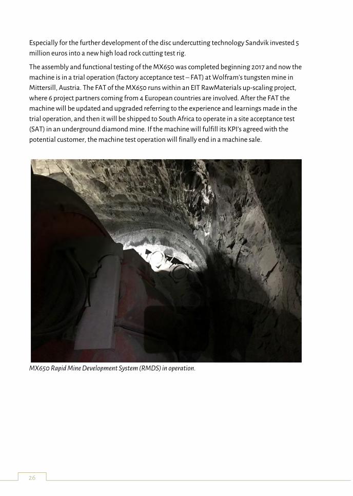
MX650 Rapid Mine Development System (RMDS) in operation.
27
Geological properties of open pit “Smreka” Vares as a pilot site for testing new mine
technology
Toni Nikolic 1, Hazim Hrvatovic 1, Mladen Rudez 2, Ismir Hajdarevic 1, Jasminka Nikolic 1,
Nijaz Skripic 2
(1) Geological Survey Federation of Bosnia and Herzegovina, Ustanicka 11, 71210 Ilidza,
Sarajevo, BIH
(2) Foundation for develop and renewal Vares region, Zvijezda 34, 71330 Vares, BIH
Key words: VAMOS, geology, underwater mineral exploit, iron, hydrogeology
Our teams FZG and FORRV apply over VAMOS consortium to EU Horizon 2020 for be member
of teams who will work on develop mine system for underwater ore exploit. Abandoned iron
mine “Smreka” was ideal place for testing new machine. Mine was operative till 1991. After
exploitation, underground and surface water fill mine with water and made artificial lake.
Over our obligation in consortium we should prepare geological properties for make adequate
drilling equipment, depend from how strong is material that will be drilled underwater. Before
testing will be made we made some research and support other teams to make correct
overview complete mine:
Support data for made 3D model last measured area from 1986. (MUL),
Support achieve data equipment, workers and production when mine was operative
for make economy study exploitation (MUL),
Take sample iron ore (siderite and hematite) for laboratory geomechanical testing
(SAND) ,
Basic water quality testing (FZG),
Data about position and space around mine for install testing equipment (FORRV),
Support team for basic bathymetry testing on the field (Geocentar-INSCE)
Before testing we should make achieve data base related for mine in time operative mine:
Number of machine who was direct and indirect be included in exploitation,
Number of workers and working time employed person with salary and cost of
production ore,
Weather condition who can impact on exploitation,
Any issues who can extra impact on price of ore (underground water, instability of
mine cut, ecology impact,…etc.).
Preparation for testing period on the site Vares should made with all predicted issues, with
especial attention on ecology and possible impact on water or soil around testing area. One of
28
positive result this project is ecology clean exploitation, where will all over process testing
collect water for checking possible impact, and stop in any moment if that limit been over
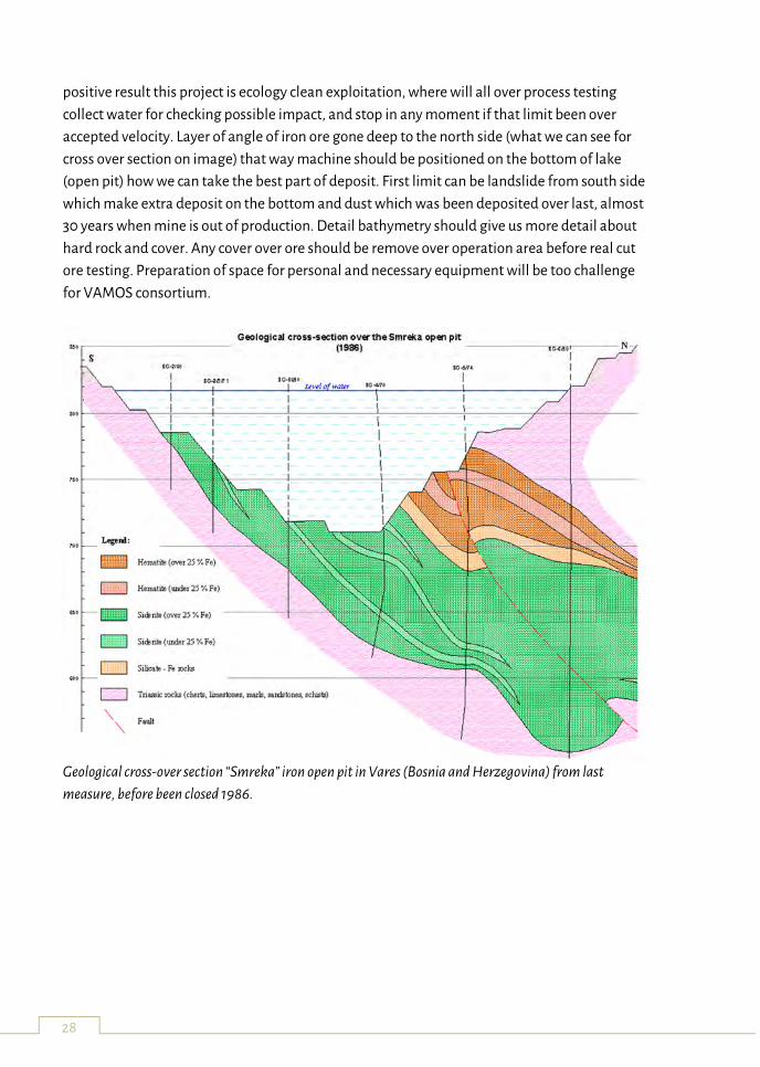
accepted velocity. Layer of angle of iron ore gone deep to the north side (what we can see for
cross over section on image) that way machine should be positioned on the bottom of lake
(open pit) how we can take the best part of deposit. First limit can be landslide from south side
which make extra deposit on the bottom and dust which was been deposited over last, almost
30 years when mine is out of production. Detail bathymetry should give us more detail about
hard rock and cover. Any cover over ore should be remove over operation area before real cut
ore testing. Preparation of space for personal and necessary equipment will be too challenge
for VAMOS consortium.
Geological cross-over section “Smreka” iron open pit in Vares (Bosnia and Herzegovina) from last
measure, before been closed 1986.
29
Real-time 3D mine model updates in the ¡VAMOS! Project
Andreas Nüchter 1 & Michael Bleier 1
(1) Zentrum für Telematik e.V., Germany
This talk presents approaches to real-time 3D mine modelling in the project Viable Alternative
Mine Operating System (¡VAMOS!), which is funded by the European Union’s Horizon 2020
research and innovation programme. The objective of this project is the development of a
prototype mining system to extract raw materials from a water-filled open-pit mine. These
inland mines have been considered depleted in the past because with previous mining
techniques it was not economically viable anymore to continue operations. Today, with rising
prices of certain rare ores it might become interesting again to re-open abandoned mines in
order to access deeper seated minerals. However, conventional mining techniques require high
treatment and dewatering costs. Moreover, from an environmental perspective it is desirable
that the water table of these flooded inland mines is not changed. Therefore, the ¡VAMOS!
project aims to develop a new remotely controlled underwater mining machine and associated
launch and recovery equipment, which provides a mining technique that is environmentally
and economically more viable than the state-of-the-art.
Excavation of raw materials in a water filled open-pit mine requires a detailed 3D mine model
for remote operations of the mining machine. The perception sensor data can only be
communicated via a computer interface. Therefore, the operator has to rely on the presented
visualizations for remote control. We describe post-processing techniques for creating an
improved 3D model from a pre-survey of a submerged inland mine and methods for updating
this initial model in real-time during operations. In the ¡VAMOS! project a virtual reality scene
is created for immersive data visualization which includes a 3D map of the mining
environment. Models of the miner and launch and recovery vehicle are displayed in the scene
using live positioning information. This provides a better overview of the operations compared
to the limited field of view of the imaging sensors attached to the mining vehicle. Free-
viewpoint renderings of the data are created to give the operator a good understanding and
situational awareness of what is happening below the water surface.
Signed distance function (SDF) based mapping is employed to fuse the measurements from
multiple scans into a consistent representation. SDF voxel maps represent the surfaces
implicitly by storing in each voxel cell the signed distance to the closest surface. Typically, the
signed distance is only stored in a narrow band around the surfaces, which is referred to as a
truncated signed distance function (TSDF). This representation is beneficial because noisy
measurements are smoothed over multiple observations. Using a generalized sensor model
approach, we integrate range data from different sensor types, such as multibeam sonar,
30
structured light scanners or acoustic cameras. This also allows us to continuously update the
map during operations and integrate new sensor observations in real-time. From the signed
distance function model, we reconstruct a 3D surface mesh of the mine. This way for
visualization we only need to update the part of the mine model that has changed which
reduces the computational requirements. We use this terrain model to establish a virtual
reality scene for immersive data visualization of the mining operations for planning during
development and operations during the testing phase.
¡VAMOS! leaves interesting questions on how the acquired 3D mine maps can be augmented
and enriched with additional information. Especially, for the purpose of auditing the
operations and monitoring the environmental data this is potentially very useful. By
monitoring the changes of the terrain over time and correlating it with in-situ measurements,
such as ore concentrations, we hope to gather necessary data points to help evaluate the
viability and impact of the project.
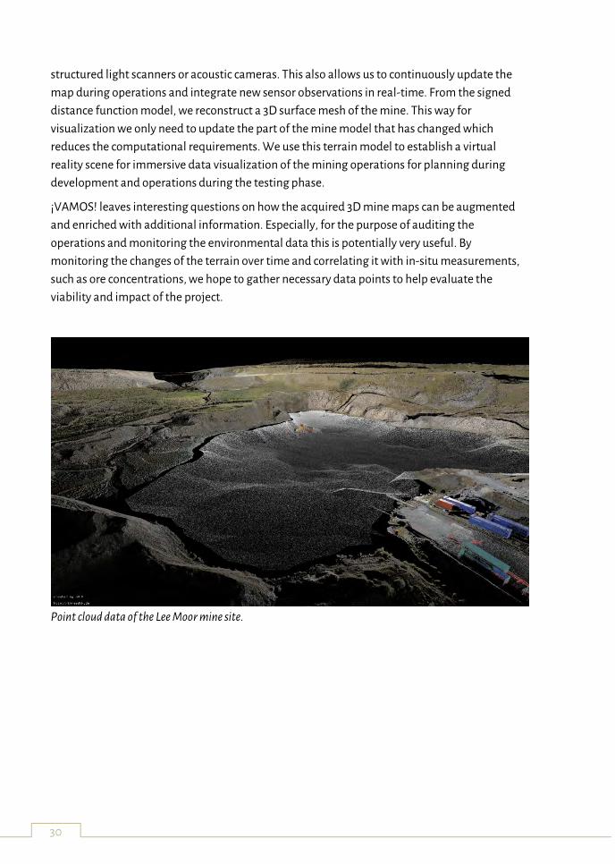
Point cloud data of the Lee Moor mine site.
31
Defragmentation of information on abandoned underground mines in the
framework of the UNEXMIN project
Giorgia Stasi 1 & Yves Vanbrabant 1
(1) Geological Survey of Belgium, Royal Belgian Institute for Natural Sciences, Rue Jennerstraat,
13 – BE-1000 Brussels
The UNEXMIN project aims to develop autonomous submarine robots to explore, map and
characterize abandoned, underground and usually flooded mines in Europe. The presence of
these old infrastructures represent a unique opportunity to conduct deep exploration before
any extension or development of a new mine. The exploration and the risk assessment are
therefore the dual objective of UNEXMIN project that can be achieved through the exploration
by robotic equipment. In addition, the integration of existing information related to the mining
history of the investigated regions is important in order to plan the exploration missions and to
further develop the UNEXMIN robots usage.
The information related to the abandoned mines in Europe are commonly spread between
different authorities, associations or publications, and are available in different formats for
each EU countries. It is therefore not a straightforward exercise to find all the required
information to complete the UNEXMIN database.
The data collection for the UNEXMIN database has been conducted by the Geological Survey of
Belgium for 8 countries, namely: United Kingdom, Sweden, Germany, Switzerland, Slovakia,
Denmark, Croatia and Cyprus.
The required data are the mine name(s), its localisation, its accessibility, the extracted
commodities, the geological information related to the available maps and sections, the
primary and secondary deposits, the ownership, the mine type (underground, open-pit), its
size, the activity level and the mine closure reasons, the potential legal restrictions and any
other useful information.
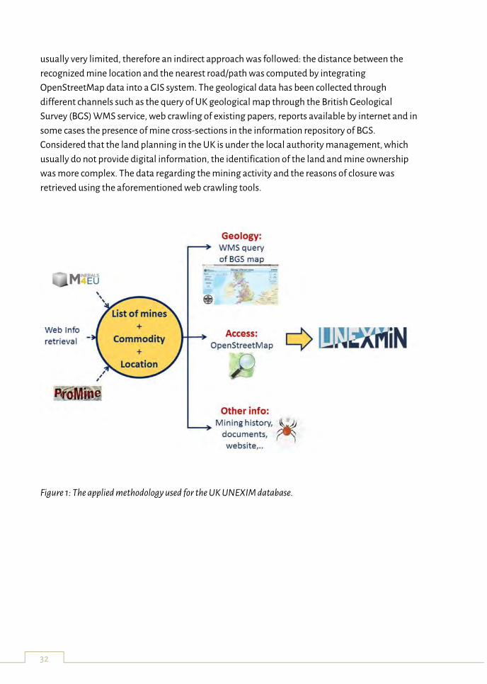
The applied methodology and the information retrieval tools, especially those oriented to the
web crawling, that have been used to fill the database can be illustrated by describing the data
collection realised for the United Kingdom (Figure 1).
The process started with the listing of the known mines. The first step was focusing on existing
databases such as Promine and Minerals4EU, but the number of listed mines for the UK was
quite low (~300) and in many cases these were actually mining districts that could host several
mines with different history. The consultation of other online resources, such as websites
developed by regional history associations, allowed to strongly increase the number of
identified mining sites to more than 5800 entries. The associated commodities were usually
found along with the mine name and its location. Information regarding mine accessibility was
32
usually very limited, therefore an indirect approach was followed: the distance between the
recognized mine location and the nearest road/path was computed by integrating
OpenStreetMap data into a GIS system. The geological data has been collected through
different channels such as the query of UK geological map through the British Geological
Survey (BGS) WMS service, web crawling of existing papers, reports available by internet and in
some cases the presence of mine cross-sections in the information repository of BGS.
Considered that the land planning in the UK is under the local authority management, which
usually do not provide digital information, the identification of the land and mine ownership
was more complex. The data regarding the mining activity and the reasons of closure was
retrieved using the aforementioned web crawling tools.
Figure 1: The applied methodology used for the UK UNEXIM database.
33
UX-1 Guidance, Navigation and Meta-control Software
Zorana Milošević 1, Ramon Suarez 1, Sergio Dominguez 1, Claudio Rossi 1
(1) Centre for Robotics and Automation, UPM-CSIC, Madrid, Spain
Key words: Autonomy, Guidance, Navigation, Self-adaptation
The objective of this abstract is to introduce the public to the autonomous guidance and
navigation of the UX-1 underwater vehicle and to give a basic idea of meta-control and how it
can be used for the aforementioned problem.
The development of the guidance and navigation system for UX-1 is a complex task, due to
many challenges posed by the unique environment it will navigate in. The first big problem is
the communication, since we cannot count on the conventional communication systems, such
as GPS or radar. An another difficulty is that the probability of encountering a totally new
problem is extremely high. Efficient maneuvering and obstacle avoidance are big challenges
for the UX-1 under unpredictable scenarios, which play an important role in defining the
degree of autonomous behavior and mission planning for UX-1. Path planning is affected by
many factors, some of them are:
Whether or not a mine is being explored for the first time (this affects the “confidence”
of the robot, the waypoints will be further away if we had already explored the part of
the mine we are now in)
The battery level (when battery level drops below a certain threshold, mission planner
will change a current mission in order to come back to the station before the battery
dies)
Whether or not the scientific measurements are being taken (the current mission
provided by the mission planner will be affected if the vehicle is required to be
motionless while taking the specific measurements)
Software or hardware faults that have to be taken care of immediately.
In order to solve uncertainties at runtime, the solution lies at the very core of control
engineering: the feedback loop. However, control loops are usually closed for certain
capabilities and the system suffer the development-runtime gap: the system does not have the
explicit knowledge at runtime to adapt if they are compromised by unexpected events. The
solution we propose is Model-Driven Engineering with Model-Based Cognitive Control. The
idea is the integration of a metacontroller in the control architecture, capable of perceiving the
dysfunctional components of the system and reconfiguring it.
34
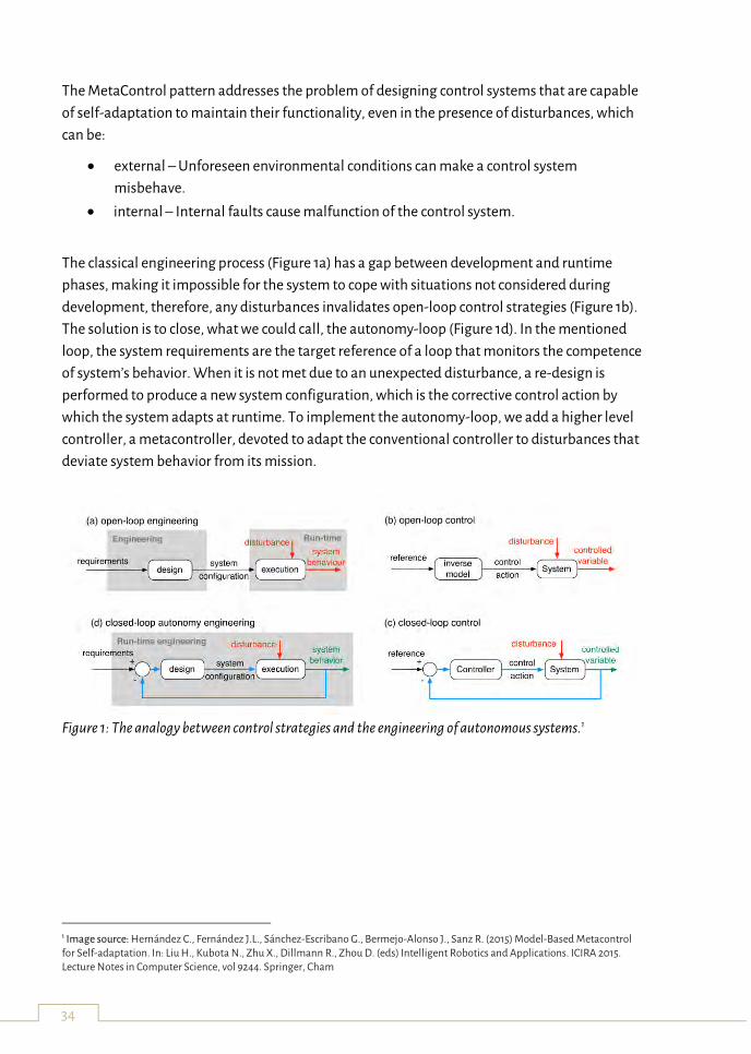
The MetaControl pattern addresses the problem of designing control systems that are capable
of self-adaptation to maintain their functionality, even in the presence of disturbances, which
can be:
external – Unforeseen environmental conditions can make a control system
misbehave.
internal – Internal faults cause malfunction of the control system.
The classical engineering process (Figure 1a) has a gap between development and runtime
phases, making it impossible for the system to cope with situations not considered during
development, therefore, any disturbances invalidates open-loop control strategies (Figure 1b).
The solution is to close, what we could call, the autonomy-loop (Figure 1d). In the mentioned
loop, the system requirements are the target reference of a loop that monitors the competence
of system’s behavior. When it is not met due to an unexpected disturbance, a re-design is
performed to produce a new system configuration, which is the corrective control action by
which the system adapts at runtime. To implement the autonomy-loop, we add a higher level
controller, a metacontroller, devoted to adapt the conventional controller to disturbances that
deviate system behavior from its mission.
Figure 1: The analogy between control strategies and the engineering of autonomous systems.1
1 Image source: Hernández C., Fernández J.L., Sánchez-Escribano G., Bermejo-Alonso J., Sanz R. (2015) Model-Based Metacontrol for Self-adaptation. In: Liu H., Kubota N., Zhu X., Dillmann R., Zhou D. (eds) Intelligent Robotics and Applications. ICIRA 2015. Lecture Notes in Computer Science, vol 9244. Springer, Cham
35
UNEXMIN Post-Processing Software
Steve Henley 1, Hilco van Moerkerk 1, Mike McLoughlin 1, James Tweedie 1
(1) RCI / 4dcoders, United Kingdom
A suite of software has been developed for processing, modelling, and interpretation of data
recorded by instrumentation and the navigation systems on the UNEXMIN submersible robots.
The software consists of a series of applications, both stand-alone and built around existing
products GEOREKA, Rockmate, and VMINE. All data streams are converted by specialized
conversion software into a central SQLite database. Data will consist of point clouds provided
by the navigation system, onto which will be mapped camera images from the colour, UV, and
multispectral camera systems. The software handles potentially hundreds of millions of points
in the point clouds by dedicated state-of-the-art visualization and analysis tools. Mineralogical
and geological data can be obtained from the point cloud through novel and as yet, unverified,
statistical interpretation of multispectral data attributed to the points. Advanced structural
interpretation of rock fracture orientations in combination with rock fall detection software,
which compares mission data from multiple missions, allows for full structural safety
assessments. Additionally, standard statistical and graphical applications may be used for
representation of environmental data from pH, conductivity, temperature, natural gamma,
and magnetometer instruments.
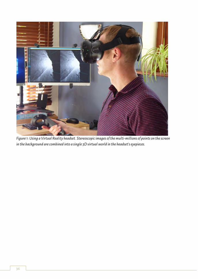
Finally, three-dimensional visualisation applications have been developed, with the ability to
use virtual reality headsets (Figure 1) and 3D projectors with hundreds of millions of points, and
the potential for hardcopy output using laser-etched glass blocks, computed holograms, and
3D printers.
The detailed data analysis and visualisation from this range of techniques will aid the planning
of a sequence of dive missions, and will help to locate areas for more detailed exploration by
the robot.
Ultimately, the purpose is to provide detailed models of geology, structure and mineralogy
upon which further decisions about possible reopening of the mine can be based, as well as
giving valuable archaeological data from heritage sites and an excellent set of tools for use by
research and educational organisations.
36
Figure 1: Using a Virtual Reality headset. Stereoscopic images of the multi-millions of points on the screen
in the background are combined into a single 3D virtual world in the headset's eyepieces.
37
Use of neural networks for the modelling, classification or categorisation tasks in
geo-sciences
Gorazd Žibret
Geological Survey of Slovenia, Dimičeva ulica 14, SI - 1000 Ljubljana, Slovenia
Key words: neural networks, data mining, geological data, information
The aim of this contribution is to get the audience familiar with the wide range of possibilities
where neural networks can be applied to address problems in classification, categorisation or
control in different branches of geo-sciences, including use of robotics for mineral prospection
and extraction. Several case studies from the field of geo-science will show many examples
where neural networks can be efficiently applied to address a wide range of problems. Their
superiority in comparison to standard statistical and geostatistical models is several-fold:
any types of data can be used to construct models, including ordinal or attributive
data, which is very common in geo-sciences (like rock or soil type),
they are noise tolerant,
tolerant to missing data,
their modular architecture allows to address a variety of different problems,
non-linear in nature, the same, as the majority of processes in nature (in contrast to
linear algebra),
they are universal approximators - they can approximate arbitrary function with
arbitrary precision and accuracy, as far as we are operating with enough learning data
and neural network, which is complex enough.
Neural networks were successfully applied in geo-oriented problems, and these successful
applications are demonstrated during the presentation, including:
making of distribution maps (i.e. isotopic composition of underground waters,
distributions of elements in different media, an example is included as figure)
function approximation and extrapolation (i.e. making of pedological maps,
modelling of discharges of surface and underground waters)
modelling (making of landslide susceptibility maps, a decision-support systems for
minerals planning, water discharge)
classification and categorisation (determination of sources of metals in the
environment in a multi-source environments, determination of neotectonic
movements in holocene sediments).
38
Process of using neural networks usually begins with the exact determination of the problem -
what are dependant and independent variables, what are the question we will try to answer,
why using neural networks (and not "usual" statistical and geo-statistical methods) etc.
Appropriate learning, evaluation and recall data sets preparation is a crucial step, because
model is so good, as good is the data. The sentence “garbage in, garbage out" is also valid for
neural networks. When the datasets are ready (learning, validation and recall matrix), the
neural network model can be constructed. Crucial points are the proper selection of network
type, learning paradigm, network topology and learning strategy. Validation is very important
process because many ill-approximation effects can arise, like over fitting or local minimum
issues. After the neural network is taught and validated, it can be used it in many ways,
whether being a model in PC simulator only, being exported as standalone programming code
to be used in different applications or on microchips, or used and teach further on by obtaining
new data from the process or environment (i.e. in an autonomous robots). Neural networks can
certainly bring the innovation component in many projects. Author personally think that their
capabilities are not exploited well enough today.
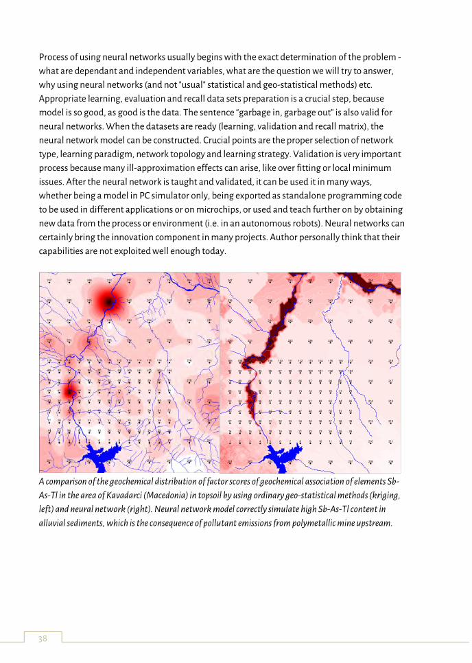
A comparison of the geochemical distribution of factor scores of geochemical association of elements Sb-
As-Tl in the area of Kavadarci (Macedonia) in topsoil by using ordinary geo-statistical methods (kriging,
left) and neural network (right). Neural network model correctly simulate high Sb-As-Tl content in
alluvial sediments, which is the consequence of pollutant emissions from polymetallic mine upstream.
1 2 3 4 5 6 7 8 9 10 11 12 13
14 15 16 17 18 19 20 21 22 23 24 25 26
27 28 29 30 31 32 33 34 35 36 37 38 39
40 41 42 43 44 45 46 47 48 49 50 51 52
53 54 55 56 57 58 59 60 61 62 63 64 65
66 67 68 69 70 71 72 73 74 75 76 77 78
79 80 81 82 83 84 85 86 87 88 89 90 91
92 93 94 95 96 97 98 99 100 101 102 103 104
105 106 107 108 109 110 111 112 113 114 115 116 117
201 202 203 204 205 206 207 208 209
210 211
212 213
214 215
216 217
218 219
220 221 222 223 224 225 226 227 228
229 230 231 232 233 234 235 236 237
238 239 240 241 242 243 244 245 246
247 248 249 250 251 252 253 254 255
39
Co-existence of men and autonomous machinery in confined underground space –
need for proximity detection and systems with functional safety
Nikolaus A. Sifferlinger
Montanuniversitaet Leoben, Erzherzog-Johann-Strasse 3, 8700 Leoben, Austria
Key words: underground, automation, autonomous, proximity protection, functional safety
In the confined space of underground mining the co-existence of men and moving machinery is
always a potential source of danger. With introduction of autonomous moving trucks in mining
it has been compulsory to fence off the areas of autonomous movements for use by other
traffic and persons.
The use of automated working cycles on mining machines which are still manned or with
personnel operating in the vicinity asks for protection systems, which avoids collision between
men and machinery.
In the United States the Mine Safety and Health Administration (MSHA) has analyzed all
accidents for Underground Coal Mining since 1984. For radio-remote controlled Continuous
Miner, where the operator works close to the machine with his radio-remote console, 38 fatal
accidents were identified. Reason for the fatalities was that the victims working close to the
machine where catched either by unplanned machine movements and/or where in the wrong
spot and have been crushed. For mobile transport machines in underground coal mining in the
same timeframe 42 fatal and 179 infringing accidents were detected, which could have possibly
avoided if a technical protection system detecting persons in danger zones and stopping the
machinery if necessary would have been available and installed.
Based on this high accident rate the National Institute for Occupational Safety and Health
(NIOSH) started in 1998 with the development of a proximity detection system for persons to
close to mining machinery in so called “No-Go or Red Zones” and also got a patent filed. Based
on this patent several companies developed Proximity Detection Systems which are available
to the mining industry. After positive operational results of the tested system the Mine Safety
and Health Administration (MSHA) has announced in March 2015 the final rule that will
strengthen protections for miners on the working section of underground coal mines by
reducing the potential for pinning, crushing, or striking accidents involving continuous mining
machines.
Also in South Africa the use of Collision Avoidance Systems between persons and machinery
become compulsory in 2015. So worldwide there are at the end of 2017 over two thousand
systems in operation.
40
Although the existing systems are a big step forward for the safety of mine operators,
operational experience shows that further development and improvement of the systems is
possible.
One of the topics is Functional Safety of the control part of the Proximity Detection Systems.
In Europe the DIRECTIVE 2006/42/EC OF THE EUROPEAN PARLIAMENT AND OF THE COUNCIL
of 17 May 2006 on safety of machinery the corresponding list on harmonized standards
presents EN IEC 62061:2005+A1:2012 “Safety of machinery - Functional safety of safety-related
electrical, electronic and programmable electronic control systems”. For the design of complex
subsystems EN IEC 62061 refers to IEC 61508 “Functional safety of electrical, electronic and
programmable electronic safety-related systems” which is based on the Safety Integrity Level
(SIL). The Safety Integrity Level is defined as a relative level of risk reduction provided by a
safety function of an Equipment under Control.
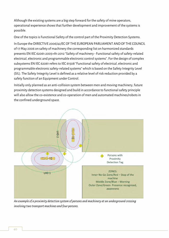
Initially only planned as an anti-collision system between men and moving machinery, future
proximity detection systems designed and build in accordance to functional safety principle
will also allow the co-existence and co-operation of men and automated machines/robots in
the confined underground space.
An example of a proximity detection system of persons and machinery at an underground crossing
involving two transport machines and four persons.
41
The ¡VAMOS! Sustainable Underwater Mining Solution
Jenny Rainbird, Senior Project Manager
BMT Group Ltd
¡VAMOS! – Viable Alternative Mine Operating System – brings together 17 partners from 10
European countries to collaborate on a jointly funded EU research project in response to a
Horizon 2020 Research and Innovation call for ‘New solutions for sustainable production of
raw materials’.
Europe is highly dependent on imports of raw materials, that are needed to support its
industries. Securing a reliable supply of minerals that are essential for the European quality of
living and economy, is a top priority for the EU. ¡VAMOS! aims to design, develop and test a
novel prototype underwater mining system capable of exploiting inaccessible inland mineral
resources that lie under the water table. This will enable the re-opening of abandoned open-pit
mines, extend the life-time of opencast mines which are limited by stripping ratio or
hydrological and geotechnical issues and will allow the opening of new mines with limited
environmental impacts in the EU.
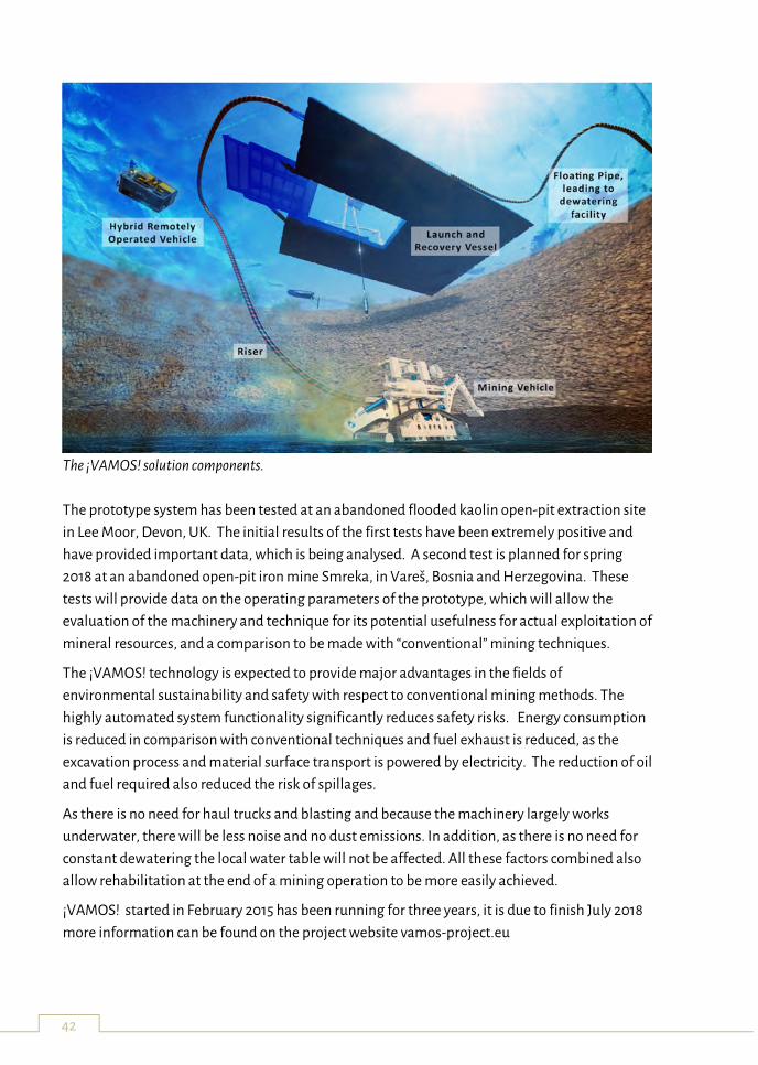
The ¡VAMOS! mining system is comprised of the following key components
1) A submerged remotely controlled mining vehicle prototype with a cutter-head for ore
gathering and equipped with laser induced breakdown spectroscopy (LIBS) for real-
time grade control. The cutter head produces fragments of about 50mm and thus
eliminates the need for a crushing facility.
2) A launch and recovery vessel used to deploy and recover the mining vehicle,
interfacing the mining vehicle to the control station, pump the mining material and
managing the hose and umbilical system.
3) A floating pipe used to transport the mining material from mining vehicle out of the
mine as a slurry and to return water to the pit.
4) An HROV/AUV for gathering data for situation modelling, obstacle avoidance data and
vehicle positioning, enable the mining machine to be controlled and operated via a 3D
virtual reality human-machine interface onshore.
42
The ¡VAMOS! solution components.
The prototype system has been tested at an abandoned flooded kaolin open-pit extraction site
in Lee Moor, Devon, UK. The initial results of the first tests have been extremely positive and
have provided important data, which is being analysed. A second test is planned for spring
2018 at an abandoned open-pit iron mine Smreka, in Vareš, Bosnia and Herzegovina. These
tests will provide data on the operating parameters of the prototype, which will allow the
evaluation of the machinery and technique for its potential usefulness for actual exploitation of
mineral resources, and a comparison to be made with “conventional” mining techniques.
The ¡VAMOS! technology is expected to provide major advantages in the fields of
environmental sustainability and safety with respect to conventional mining methods. The
highly automated system functionality significantly reduces safety risks. Energy consumption
is reduced in comparison with conventional techniques and fuel exhaust is reduced, as the
excavation process and material surface transport is powered by electricity. The reduction of oil
and fuel required also reduced the risk of spillages.
As there is no need for haul trucks and blasting and because the machinery largely works
underwater, there will be less noise and no dust emissions. In addition, as there is no need for
constant dewatering the local water table will not be affected. All these factors combined also
allow rehabilitation at the end of a mining operation to be more easily achieved.
¡VAMOS! started in February 2015 has been running for three years, it is due to finish July 2018
more information can be found on the project website vamos-project.eu
43
Real -Time Mining: Sensors for materials characterization
Feven Desta 1, Mike Buxton 1, Harald van der Werff 2, Marinus Dalm 1 (1) TU Delft, The Netherlands (2) University of Twente, The Netherlands
Key words: sensor data, RGB, FTIR, hyperspectral imaging, polymetallic sulphide ore, material discrimination Sensors are being used as laboratory and in-situ techniques for characterization and definition
of raw material properties. However, application of sensor technologies for underground
mining resource extraction is very limited and highly dependent on the geological and
operational environment. In our study the potential of RGB imaging, Fourier-Transform
Infrared Spectroscopy (FTIR) spectroscopy and Hyperspectral imaging for the characterization
of polymetallic sulphide minerals in a test case of the Reiche Zeche underground mine was
investigated.
In our previous work we have demonstrated the use of RGB imaging for ~4m long mine
face mineral mapping. In this study the application was extended to map ~ 22m long mine
face, to define an ore geometry and to generate quantitative fragmentation analysis
results. The mine face images were georeferenced, mosaicked and a mineral map was
produced using a supervised image classification technique. The overall classification
accuracy shows the potential of the technique for the delineation of sulphide ores in an
underground mine. RGB images acquired at muck pile sites were used to generate
quantitative fragmentation analysis result. The analysis performed using the RGB images
provided satisfactory quantitative results (grain size distribution curve). Taking in to
account the blasting parameters, the result can further be used for development of models
that better predict fragmentation in the test case.
Our previous study has indicated the use of FTIR technology for discrimination of ore-
waste using powder samples. In this study, the application was extended using whole rock
samples. Due to the heterogeneous nature of rock samples multiple FTIR measurements
were acquired at different spots of the rock surface. The FTIR data combined with Partial
Least Square - Discriminant Analysis (PLS-DA) technique was used to assess the use of the
technique for whole rock application. A series of calibration models were developed for ore
and waste materials separately. The models were validated using independent dataset.
The classification result obtained from whole rock application is remarkable. However
compared to the powder samples application, the classification model accuracy is lower.
This is likely due to the heterogeneous nature of the rock materials and the rough surface
of the rock materials. Therefore for better classification accuracy an improved way of
heterogeneity assimilation should be taken in to account. In general, the result obtained
from the whole rock application is promising and with proper model calibration and
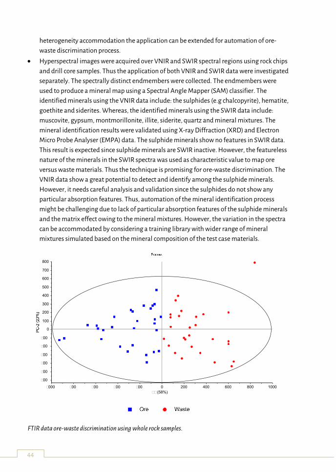
44
heterogeneity accommodation the application can be extended for automation of ore-
waste discrimination process.
Hyperspectral images were acquired over VNIR and SWIR spectral regions using rock chips
and drill core samples. Thus the application of both VNIR and SWIR data were investigated
separately. The spectrally distinct endmembers were collected. The endmembers were
used to produce a mineral map using a Spectral Angle Mapper (SAM) classifier. The
identified minerals using the VNIR data include: the sulphides (e.g chalcopyrite), hematite,
goethite and siderites. Whereas, the identified minerals using the SWIR data include:
muscovite, gypsum, montmorillonite, illite, siderite, quartz and mineral mixtures. The
mineral identification results were validated using X-ray Diffraction (XRD) and Electron
Micro Probe Analyser (EMPA) data. The sulphide minerals show no features in SWIR data.
This result is expected since sulphide minerals are SWIR inactive. However, the featureless
nature of the minerals in the SWIR spectra was used as characteristic value to map ore
versus waste materials. Thus the technique is promising for ore-waste discrimination. The
VNIR data show a great potential to detect and identify among the sulphide minerals.
However, it needs careful analysis and validation since the sulphides do not show any
particular absorption features. Thus, automation of the mineral identification process
might be challenging due to lack of particular absorption features of the sulphide minerals
and the matrix effect owing to the mineral mixtures. However, the variation in the spectra
can be accommodated by considering a training library with wider range of mineral
mixtures simulated based on the mineral composition of the test case materials.
FTIR data ore-waste discrimination using whole rock samples.
PC-1 (58%)
-1000 -800 -600 -400 -200 0 200 400 600 800 1000
-600
-500
-400
-300
-200
-100
0
100
200
300
400
500
600
700
800
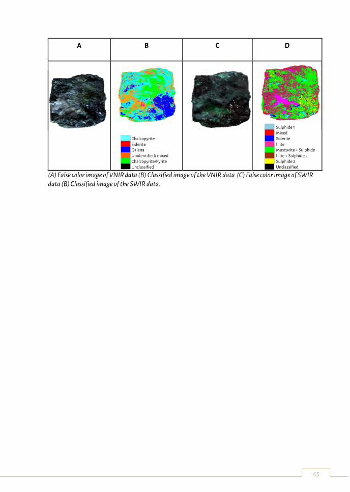
45
A B C D
(A) False color image of VNIR data (B) Classified image of the VNIR data (C) False color image of SWIR data (B) Classified image of the SWIR data.
Chalcopyrite Siderite Galena Unidentified/ mixed Chalcopyrite/Pyrite Unclassified
Sulphide 1 Mixed Siderite Illite Muscovite + Sulphide Illite + Sulphide 2 Sulphide 2 Unclassified
46
UNEXMIN project: an underwater explorer for flooded mines
Luís Lopes
La Palma Research Centre, El Frontón 37, 38787 Garafía, Canary Islands, Spain
Key words: flooded mines, robot, mining, exploration, autonomy
UNEXMIN, an EU-funded Horizon2020 project, is developing a multi-platform system, formed
by three robots, for the autonomous exploration and mapping of flooded underground mines.
The robotic explorer – UX-1 – will use non-invasive methods for autonomous 3D mine mapping
to gather new geoscientific and spatial data from the mines, their environment, and
characteristics. These data cannot be currently obtained, except from other more expensive or
hazardous methods, and UNEXMIN will thus fill an important data gap.
Deploying a robot in flooded underground mines, considering that it needs to work
autonomously, without damaging the equipment or the site, constrains basic robotic functions
- movement, autonomy, mapping, etc. - as well as the dimensions and weight of the
submersible, making this a demanding task. The common characteristics of underwater mines
such as low visibility, presence of obstacles, danger of falling rocks and debris and water acidity
plus difficulties in maneuvering, all contribute to the challenges that UX-1 faces. The main
challenge areas in UNEXMIN are related to (1) the explorer structural design, (2) localization,
navigation and 3D mapping, (3) guidance, propulsion and control, (4) autonomous operation
and (5) data processing and evaluation.
The submersible’s development is focussing, but not only, on (1) validation and simulation of
robotic functions, (2) designing, testing and adaptation of scientific instruments, (3) framing
mine perception, navigation, 3D mapping and exploration means and (4) creating post-
processing and data analysis tools. These steps are evolving in both laboratory and field tests
alike and will culminate with the construction of the first UX-1 robotic prototype, envisaged for
early-2018.
UX-1 is being developed with a spherical shape of about 0.6m in diameter, an expected weight
of 112Kg, a maximum operation depth of 500m and autonomy for 5 hours. Altogether, UX-1 will
be able to perform its missions thanks to technologies and equipment derived from areas like
autonomous control, 3D mapping and deep-sea robotics. The robot’s instrumentation set can
be divided in equipment necessary for basic robotic functions, which includes thrusters, optical
and acoustic cameras, a structured light system (SLS) including laser and white light, pendulum
and buoyancy control systems, batteries, a computer and a pressure hull, and scientific
instruments that will generate valuable geological and spatial data, including water sampler,
conductivity and pH measuring units, a sub-bottom profiler, a magnetic field measuring unit,
UV fluorescence imaging and multispectral imaging units. The different instrumentation
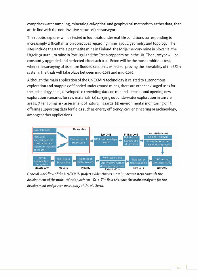
47
comprises water sampling, mineralogical/optical and geophysical methods to gather data, that
are in line with the non-invasive nature of the surveyor.
The robotic explorer will be tested in four trials under real life conditions corresponding to
increasingly difficult mission objectives regarding mine layout, geometry and topology. The
sites include the Kaatiala pegmatite mine in Finland, the Idrija mercury mine in Slovenia, the
Urgeiriça uranium mine in Portugal and the Ecton copper mine in the UK. The surveyor will be
constantly upgraded and perfected after each trial. Ecton will be the most ambitious test,
where the surveying of its entire flooded section is expected, proving the operability of the UX-1
system. The trials will take place between mid-2018 and mid-2019.
Although the main application of the UNEXMIN technology is related to autonomous
exploration and mapping of flooded underground mines, there are other envisaged uses for
the technology being developed: (1) providing data on mineral deposits and opening new
exploration scenarios for raw materials, (2) carrying out underwater exploration in unsafe
areas, (3) enabling risk assessment of natural hazards, (4) environmental monitoring or (5)
offering supporting data for fields such as energy efficiency, civil engineering or archaeology,
amongst other applications.
General workflow of the UNEXMIN project evidencing its most important steps towards the
development of the multi-robotic platform, UX-1. The field trials are the main catalysers for the
development and proven operability of the platform.

48
49
Workshops
Workshop 1: Exploitation Workshop
led by Geological Survey of Slovenia and BTM Group
Ensuring that the technology developed within research is exploited to its full potential is a very
important part of almost every H2020 project. It assures that taxpayer's money is properly
spent and that EU citizens benefit from funding international R&I projects, like UNEXMIN,
iVAMOS! and RTM, whether providing new jobs for EU citizens, providing high-quality
scientific knowledge in the form of publications, enabling EU companies to be world leaders by
owning technological patents and contributing to better legislation.
The workshop will be based around a hypothetical project that has a potentially very useful and
highly marketable new technology, which has been developed by a consortium, consisted of
large industrial partners, SMEs, public research institutes and universities. In this hypothetical
scenario a lot of useful knowledge and know-how has been generated, which can be used by
many partners individually. However, the technology as a whole still needs some investment in
order to reach the target market, where great success is expected. We will use a carousel to
discuss and propose best exploitation strategies for this scenario.
The results of this workshop will be beneficial for both, iVAMOS! and UNEXMIN projects.
Workshop 2:Research Roadmapping Workshop
led by La Palma Research Centre for Future Studies
The research roadmapping workshop aims to develop a strategic research agenda for both
UNEXMIN and ¡VAMOS! projects. The roadmap exercise will assess future challenges for
research and technology development against the backdrop of alternative futures by exploring
different raw materials scenarios. Experts are invited to actively engage in the discussions,
supporting the evaluation of technical, policy, environmental and economic aspects of the
emerging technologies. The results will serve as basis for developing a technology roadmap for
each project.

50
51
Field Trip Guide
Idrija and its Mercury
Idrija is a town with the oldest mining tradition in Slovenia. Its history is inseparably linked to
the five century-long extraction of a precious metal – mercury. Today, the town takes pride in
its rich cultural and natural heritage.
Owing to the exceptional importance of their mercury heritage, Idrija and the Spanish
Almadén are now listed on UNESCO’s World Heritage List.
The ore deposit was formed more than 240 million years ago as the result of intensive tectonic
and volcanic activity in this region. Rising from the depths were mercury-rich solutions that
flowed along the rock faults. As they cooled, the mineral cinnabar (HgS) began to crystallise. A
particularity of the Idrija ore deposit is native mercury.
Mercury (Hg) is the only metal in a liquid state at normal temperatures. It is 13.6 times heavier
than water and almost two times heavier than iron.
The discovery of mercury dates back to the year 1490. Legend has it that mercury was
discovered by a tubmaker as he was soaking a wooden bucket in a stream. Over a period of 500
years, Idrija miners dug out more than 700 km of galleries. The deepest parts of the mine
reached a depth of 382 m or 36 m below sea level. As many as 147,000 tons of mercury were
extracted from cinnabar ore, but almost one third of this quantity was lost in the extraction
process. The Idrija Mine was, by its quantity of extracted mercury, the second largest mercury
mine in the world. Only Almadén in Spain had a larger mercury output. Owning to the
exceptional significance of the mine, Idrija has for three centuries preserved the status of an
fimperialg town. Experts from across Europe came to Idrija, where they designed and created
innovations of European significance. Mercury with its exceptional significance marked the
development of Idrija and contributed to the flourishing of human civilisation throughout the
world.
Anthony's Main Road and Hg Smelting Plant
A visit to the oldest part of the mercury mine in Idrija is an unforgettable experience. Visitors
enter Anthony's Main Road through the prominent Šelštev building (former call room)
and,dressed in green-black overalls and wearing a helmet, they embark on an unforgettable
underground journey through mining history. The path through illuminated shafts leads to the
underground Chapel of the Holy Trinity. Visitors descend into the depths of the mine along
steep wooden stairs, observing mercury drops trickling from the dark rocks. In the company of
a guide, they learn about the toilsome work of miners and search for the mischievous mine
dwarf named Prekmandlc.
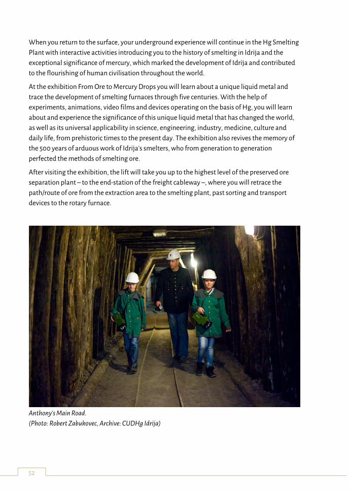
52
When you return to the surface, your underground experience will continue in the Hg Smelting
Plant with interactive activities introducing you to the history of smelting in Idrija and the
exceptional significance of mercury, which marked the development of Idrija and contributed
to the flourishing of human civilisation throughout the world.
At the exhibition From Ore to Mercury Drops you will learn about a unique liquid metal and
trace the development of smelting furnaces through five centuries. With the help of
experiments, animations, video films and devices operating on the basis of Hg, you will learn
about and experience the significance of this unique liquid metal that has changed the world,
as well as its universal applicability in science, engineering, industry, medicine, culture and
daily life, from prehistoric times to the present day. The exhibition also revives the memory of
the 500 years of arduous work of Idrija's smelters, who from generation to generation
perfected the methods of smelting ore.
After visiting the exhibition, the lift will take you up to the highest level of the preserved ore
separation plant – to the end-station of the freight cableway –, where you will retrace the
path/route of ore from the extraction area to the smelting plant, past sorting and transport
devices to the rotary furnace.
Anthony's Main Road.
(Photo: Robert Zabukovec, Archive: CUDHg Idrija)
53
Attendance List
Alexander Wimmer ǀ Neuman Aluminium ǀ
Alfredo Martins ǀ INESC TEC ǀ
André Dias ǀ INESC TEC ǀ
Andreas Nüchter ǀ Zentrum für Telematik e.V. ǀ
Anita Demény ǀ European Federation of Geologists ǀ
Aranka Földessy ǀ University of Miskolc ǀ
Arthur Poliakov ǀ Advantix Ltd ǀ
Carlos Almeida ǀ INESC TEC ǀ
Christian Burlet ǀ Geological Survey of Belgium ǀ
Claudio Rossi ǀ Universidad Politécnica de Madrid, Centre for Automation and Robotics ǀ
Csaba Vörös ǀ University of Miskolc ǀ
Damjan Velkovski ǀ
Daniela Bombol ǀ Reservoir Minerals Macedonia ǀ
Diana Viegas ǀ INESC TEC ǀ
Dirk Jan van Waardhuizen ǀ Trelleborg Ridderkerk BV ǀ
Duška Rokavec ǀ Geological Survey of Slovenia ǀ
Edine Bakker ǀ La Palma Research Centre for Future Studies ǀ
Eduardo Silva ǀ INESC TEC ǀ
Eszter Farkas ǀ Geo-Montan ǀ
Ferenc Madai ǀ Hungarian Geological Society ǀ
Feven Desta ǀ Delft University of Technology, Faculty of Civil Engineering and Geosciences ǀ
Frank Bosman ǀ Damen Dredging Equipment ǀ
54
Giorgia Stasi ǀ RBINS - Geological Survey of Belgium ǀ
Gorazd Žibret ǀ Geological Survey of Slovenia ǀ
Hazim Hrvatović ǀ Geological Survey of Federation of Bosnia and Herzegovina ǀ
Hein Raat ǀ KNGMG ǀ
Hilco van Moerkerk ǀ RCI / 4dcoders ǀ
Ian Stewart ǀ Fugro ǀ
Izudin Sjerotanović ǀ BBM-VAREŠ d.o.o. Vareš ǀ
James Tweedie ǀ RCI / 4dcoders ǀ
Janos Horvath ǀ Geo-Montan ǀ
Jean-Jacques Royer ǀ CRNS-ENSG ǀ
Jenny Rainbird ǀ BMT Group Ltd ǀ
José Almeida ǀ INESC TEC ǀ
Jose Villa ǀ Tampere University of Technology ǀ
Jouko Laitinen ǀ Tampere University of Technology ǀ
Jure Atanackov ǀ Geological Survey of Slovenia ǀ
Jussi Aaltonen ǀ Tampere University of Technology ǀ
Kirill Khoroshenkov ǀ Sheffield Robotics ǀ
Klemen Teran ǀ Geological Survey of Slovenia ǀ
Luís Lopes ǀ La Palma Research Centre for Future Studies ǀ
Manja Žebre ǀ Geological Survey of Slovenia ǀ
Marco Konrat Martins ǀ La Palma Research Centre for Future Studies ǀ
Marinus Dalm ǀ Delft University of Technology, Faculty of Civil Engineering and Geosciences
ǀ
Markku Iljina ǀ LOIMU ry, Markku Iljina GeoConsulting Oy ǀ
55
Marko Komac ǀ OneGeology, IUGS, EGS ǀ
Marko Munih ǀ University of Ljubljana, Faculty of Electrical Engineering ǀ
Marta Mileusnić ǀ University of Zagreb, Faculty of Mining, Geology and Petroleum
Engineering ǀ
Martin Gaberšek ǀ Geological Survey of Slovenia ǀ
Márton L. Kiss ǀ University of Miskolc ǀ
Máté Koba ǀ University of Miskolc ǀ
Matjaž Marussig ǀ MARUSSIG.D.O.O. ǀ
Michael Bleier ǀ Zentrum für Telematik e.V. ǀ
Mike McLoughlin ǀ RCI / 4dcoders ǀ
Mikhail Leskov ǀ GV GOLD ǀ
Miloš Bavec ǀ Geological Survey of Slovenia ǀ
Mladen Rudež ǀ Fondacija za obnovo i razvoj regije Vareš ǀ
Mónica Sousa ǀ Portuguese Association of Geologists ǀ
Nebojša Atanacković ǀ The Serbian Geological Society ǀ
Nijaz Škripić ǀ Fondacija za obnovo i razvoj regije Vareš ǀ
Nikolaus A. Sifferlinger ǀ Montanuniversitaet Leoben ǀ
Norbert Benecke ǀ DMT GmbH ǀ
Norbert Zajzon ǀ University of Miskolc ǀ
Pedro Jorge ǀ INESC TEC ǀ
Peter Müller ǀ European Federation of Geologists ǀ
Petra Žagar ǀ Ministry of Education, Science and Sport of the Republic of Slovenia ǀ
Ralph Baltes ǀ Advanced Mining Techonolgies - RWTH Aachen University ǀ
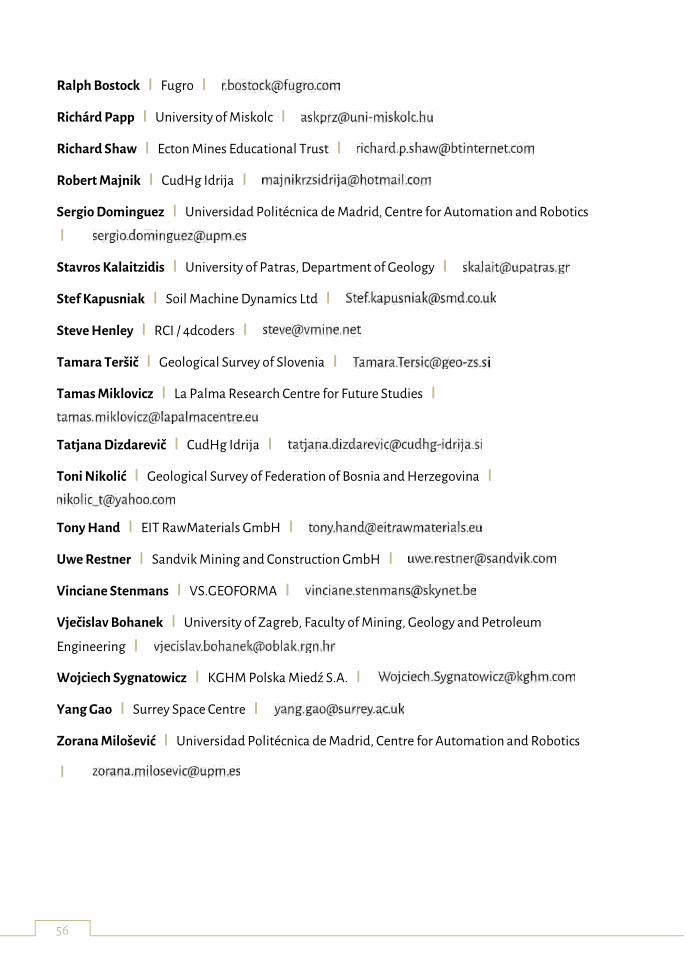
56
Ralph Bostock ǀ Fugro ǀ
Richárd Papp ǀ University of Miskolc ǀ
Richard Shaw ǀ Ecton Mines Educational Trust ǀ
Robert Majnik ǀ CudHg Idrija ǀ
Sergio Dominguez ǀ Universidad Politécnica de Madrid, Centre for Automation and Robotics
ǀ
Stavros Kalaitzidis ǀ University of Patras, Department of Geology ǀ
Stef Kapusniak ǀ Soil Machine Dynamics Ltd ǀ
Steve Henley ǀ RCI / 4dcoders ǀ
Tamara Teršič ǀ Geological Survey of Slovenia ǀ
Tamas Miklovicz ǀ La Palma Research Centre for Future Studies ǀ
Tatjana Dizdarevič ǀ CudHg Idrija ǀ
Toni Nikolić ǀ Geological Survey of Federation of Bosnia and Herzegovina ǀ
Tony Hand ǀ EIT RawMaterials GmbH ǀ
Uwe Restner ǀ Sandvik Mining and Construction GmbH ǀ
Vinciane Stenmans ǀ VS.GEOFORMA ǀ
Vječislav Bohanek ǀ University of Zagreb, Faculty of Mining, Geology and Petroleum
Engineering ǀ
Wojciech Sygnatowicz ǀ KGHM Polska Miedź S.A. ǀ
Yang Gao ǀ Surrey Space Centre ǀ
Zorana Milošević ǀ Universidad Politécnica de Madrid, Centre for Automation and Robotics
ǀ
57
Learn Slovene in 5 minutes
Here you can find some Slovene phrases, to assist you, and for you to be able to tell your friends
you have learnt some words in a language spoken by only 2 million people.
For pronunciation guidelines you can visit the following web page: http://slovlit.ff.uni-
lj.si/sft/alphabet.htm
Slovene for travellers: http://slovlit.ff.uni-lj.si/sft/
Good morning. Dobro jutro.
Good afternoon. Dober dan.
Good evening. Dober večer.
Good night. Lahko noč.
Hello. Zdravo.
Good bye. Nasvidenje.
Please / Thank you. Prosim / hvala.
I am hungry and thirsty. Sem lačen in žejen.
A glass of water please. Kozarec vode prosim.
Enjoy jour meal. Dober tek.
One beer / coffee please. Eno pivo / kavo prosim.
One drink for everybody sitting behind
this table on my account please.
Eno rundo prosim.
Cheers. Na zdravje.
I would like to pay. Plačal bi.
Where is a toilet? Kje je stranišče?
I am lost. Please, help me. Izgubil sem se. Prosim, pomagajte.

58

59
Notes