Embed Size (px)
Citation preview
3
3, Suleman Chambers, 4 Battery Street, Mumbai 400001 7, 8th Main, 3rd Phase, Domlur 2nd Stage, Bangalore 560071
www.doccentre.net 022‐22020019 080‐25353397 [email protected]@doccentre.net
Readings on Critical Issues and Concerns for NGOs, Activists and others
concerned with Justice and Social Change
Uttarakhand: Disaster as a Tragedy
When rivers speak, the earth listens. The hissing in the grass grows still.
The leaves stop their rustling. The mountain holds its
breath. When rivers speak, listen!
For who Knows what the voice will be?1
On 16-17 June this year, the Alaknanda, Bhagirathi and Mandakini rivers spoke. And the angry hills rumbled in agreement. Many theories and explanations for the disaster have surfaced in the aftermath of the floods in the state. ISRO believes that the disaster in Uttarakhand was aggravated by the large number of landslides in the area between June16 and 17. Though a landslide inventory is still being prepared, preliminary data shows that a total of 745 landslides occurred along the river valleys of Mandakini, Mandani, Kali and Madhyamaheshwar. The debris created by these landslides was carried along with the flood water and added to the destruction. Early rains coupled with other factors were responsible for the disaster that ensued. Rivers in the region already have heavier flow in June than at other times of the year because of the seasonal melting of glaciers. When water falls on ice, it melts faster; and as it rained on the glaciers of the state, the massive run-off began to swell the rivers. 1from `I am Woman. I am River` by Ujwala Samarth; in ‘Asking We Walk: The South as a new political imaginary’ edited by Corrine Kumar. Streelekha , Bangalore, 2007.
“Was what happened in Uttarakhand last month or in Ladakh in 2010 simply accidental? They were tragedies from start to finish as the warning signs were everywhere in big, bold font, but were deliberately and repeatedly ignored. When pushed and shamed, ministers might condescend to ordering an inquiry into the "event" as if it were an accident. This lets the corrupt system off the hook so that it can kill another day.” - Dipankar Gupta. Anatomy of India’s disasters… Times of India. 20 July 2013. There is no doubt that stranded pilgrims need to be evacuated, and should be given proper medical care. In no time, the surviving pilgrims will return home, the dead will be mourned and the media will move to another sensational story. We will hear the media, the experts and the government officials raising questions about riverside encroachment, disaster management system, weather warning system and other endless discussions but they will do what they do best- lay blame on others. However, nobody will pay any attention to the plight of Rama and Shiva (local people) who are probably the worst affected. They have lost their loved ones, their homes, lands, crops, and most importantly, their livelihoods for an indefinite time. The Other Tragedy at Uttarakhand, Development Outlook, 23 June,2013.
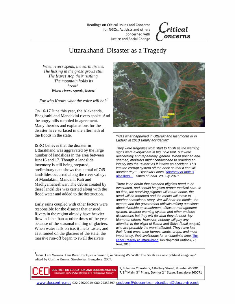
Anil Kof Junformethat focontinstreamSingh Davidof HaDeparat Durthe Un“Autostationreservrain oThis lunpreoccurmonsoAugufactoris thattime w
snow and anmounexperthat thof heameltintailor-landslUttaraDisasHumaDamsPeopl5-6: JThe edevaswas K(30.73Himayoutu For mhttp://http://
Kulkarni, glacne 16 at Kedaed during the ormed its bounuing heavy rm run-off andh, Down to Ea
d Petley, Wilsazard and Riskrtment of Georham Universnited Kingdo
omatic weathen at Chorbarivoir recorded on 15th and 16level of rainfaecedented, butrs at the peak oon in July or
ust. The impor here t the rainfall fwhen therewa
on the grounny high
ntain landslidert will tellyou he combinatioavy rainfall onng snow is the-made for lides. akhand Floodter: Role of an Actions, s, Rivers & le, Vol 11: IssJune-July 201
epicenter of thstating floods Kedarnath 3° N, 79.07° E
alayan glacier ube) indicates
more on what/blogs.agu.org/www.downto
ciologist saysarnath. A smarains above K
undary. The larain caused flad a third channarth, 3 July, 2
son Professor k in the ography sity in m says: er i 315mm
6th June. all is not t usually of the r
ortant
fell at a as still
nd –
e
on n e
d
sue 13. he
E). The Kedacalled Chorahow vulnerab
t happened sg/landslideblooearth.org.in/
Photogr [credit:
s: There was all (100 sq. heKedarnath towake water, aloash floods. It nel was forme013.
arnath temple abari. A 3D anble the area w
see og/ /content/uttara
GeomorphicThe twin gla
aph below showChoujar, 2009]
rainfall of 12ectare containwn. The lake bong with the wis because of
ed.What Real
is located in nimation of thwas to a calam
akhand-flood
c overview of theciers of Choraba
wing Kedarnath
20 mm in 24 hing 10 millionburst due to awater from thf the lake thatly Happened
the heart of thhe Kedarnath mity.
ds-disaster-hum
e Chorabari Glaari can be seen j
Temple (T) loca
hours before tn litres of wa
a breach in thee glacier and t there was exin Uttarakhan
he flood plainvalley (avail
man-induced
cier: taken fromjust above the t
ated in the path
the flash floodater) lake was e blockade the
xcessive nd, Jyothsna
ns of a able on
m Mehta et al. temple.
of the glacier sn
d
nout (RS)
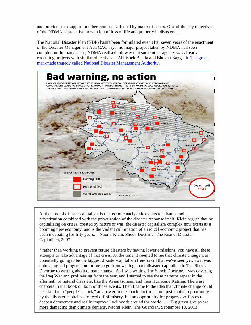
The State of Disaster Management “Will other states and central authorities be so concerned in rehabilitating the affected once the tourists and pilgrims have been evacuated and the media attention waned? Will these authorities still be looking for life under the debris of fallen houses, hotels and guesthouses? Would they still be distributing essentials to the locals (about 80-100 villages are believed to have been completely washed away by the flash floods)? Can we use this opportunity of rebuilding infrastructure also to renegotiate a new social contract? Uttarakhand must be allowed to dream a better future. – Will we forget our lessons of this disaster too?Anil Gupta, Governance Now, July 03, 2013. Public documents show that the Indian Meteorological Department didn’t publicly warn of an imminent deluge until it issued a series of advisories on 14, 15 and 16 June, when showers were underway and close to their peak. What is surprising in this episode is the lack of scientific and administrative preparedness to deal with a disaster of this magnitude. For example, Uttarakhand is home to a number of research institutions dedicated to the study of its topography and climate. The state is also at the centre of research investigations as an earthquake prone zone. Yet it does not have a reliable weather forecasting system that can foretell heavy rains at least 48 hours in advance.
There are two practical steps the state government needs to take to prevent occurrences in future. One, it needs to create a pilgrim and tourist management system and, two, it ought to devote more attention and money to regulating tourism infrastructure. Uttarakhand: a state caught unprepared, Live Mint, Jun 30, 2013. The South Asia Network on Dams, Rivers and People (SANDRP) wrote on its blog a day after the Kedarnath flood: "During June 15-17, when Uttarakhand was receiving the most intense rains, Central Water Commission (CWC) did not make any forecasts regarding Uttarakhand. As far as the most severely affected areas of the Ganga basin upstream of Devprayag are concerned (these include the worst affected Kedarnath and Mandakini valley, the Gangotri and Bhagirathi valley and Badrinath in Alaknanda valley), the CWC has made no flood forecasts at all this year. Same is the case regarding other affected regions of Uttarakhand, including the Yamuna basin that includes the Gori-Ganga basin. The CWC on which the entire nation depends for information on likely river related floods - does not have flood forecasting stations in many flood-prone river basins. The people there are clueless to impending disaster. Uttarakhand is an example. With so many rivers on its lap, the state has just three flood forecasting stations in Srinagar, Rishikesh and Haridwar, with just one (Srinagar) in the upper reaches, where all the calamity played itself out. The Coordinator of SANDRP Himanshu Thakkar points out that with just three stations and only one in the upper reaches of the Himalayan Rivers, the CWC could not have made forecasts anyway. -CWC’s game of Death, Sreelatha Menon, Business Standard, 20 July, 2013. Adaptation means not just desperate rescue during and after extreme rains, but preparing for them. Experts suggest prior warning systems are feasible, with reasonable investment. Given there was no warning from the IMD, what technological or administrative improvement do we need to ensure that advance warnings are issued before such future events? – Another Climate Change Event, Nagraj Adve, The Hindu, June 21, 2013. The National Disaster Management Agency (NDMA) The NDMA is expected to lay down policy on disaster management, approve national Disaster Management plan, lay down guidelines to be followed by Central ministries and state authorities,
and provide such support to other countries affected by major disasters. One of the key objectives of the NDMA is proactive prevention of loss of life and property in disasters… The National Disaster Plan (NDP) hasn't been formulated even after seven years of the enactment of the Disaster Management Act. CAG says: no major project taken by NDMA had seen completion. In many cases, NDMA realised midway that some other agency was already executing projects with similar objectives. – Abhishek Bhalla and Bhuvan Bagga in The great man-made tragedy called National Disaster Management Authority.
At the core of disaster capitalism is the use of cataclysmic events to advance radical privatization combined with the privatization of the disaster response itself. Klein argues that by capitalizing on crises, created by nature or war, the disaster capitalism complex now exists as a booming new economy, and is the violent culmination of a radical economic project that has been incubating for fifty years. – Naomi Klein, Shock Doctrine: The Rise of Disaster Capitalism, 2007 “ rather than working to prevent future disasters by having lower emissions, you have all these attempts to take advantage of that crisis. At the time, it seemed to me that climate change was potentially going to be the biggest disaster-capitalism free-for-all that we've seen yet. So it was quite a logical progression for me to go from writing about disaster-capitalism in The Shock Doctrine to writing about climate change. As I was writing The Shock Doctrine, I was covering the Iraq War and profiteering from the war, and I started to see these patterns repeat in the aftermath of natural disasters, like the Asian tsunami and then Hurricane Katrina. There are chapters in that book on both of those events. Then I came to the idea that climate change could be a kind of a "people's shock," an answer to the shock doctrine – not just another opportunity by the disaster capitalists to feed off of misery, but an opportunity for progressive forces to deepen democracy and really improve livelihoods around the world. .. - 'Big green groups are more damaging than climate deniers', Naomi Klein, The Guardian, September 10, 2013.
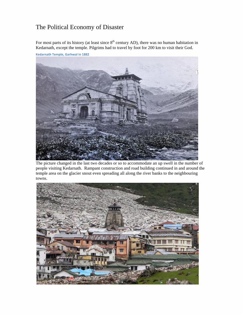
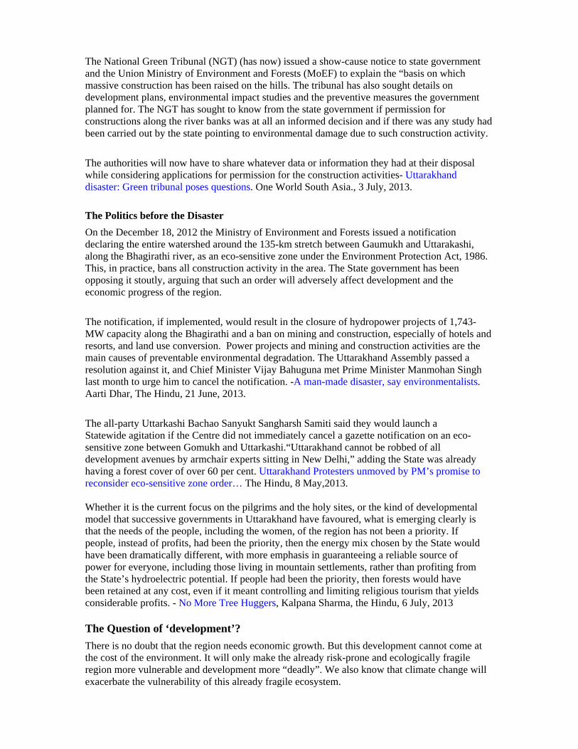
The Political Economy of Disaster For most parts of its history (at least since 8th century AD), there was no human habitation in Kedarnath, except the temple. Pilgrims had to travel by foot for 200 km to visit their God.
The picture changed in the last two decades or so to accommodate an up swell in the number of people visiting Kedarnath. Rampant construction and road building continued in and around the temple area on the glacier snout even spreading all along the river banks to the neighbouring towns.
Kedarnath Temple, Garhwal in 1882
The National Green Tribunal (NGT) (has now) issued a show-cause notice to state government and the Union Ministry of Environment and Forests (MoEF) to explain the “basis on which massive construction has been raised on the hills. The tribunal has also sought details on development plans, environmental impact studies and the preventive measures the government planned for. The NGT has sought to know from the state government if permission for constructions along the river banks was at all an informed decision and if there was any study had been carried out by the state pointing to environmental damage due to such construction activity.
The authorities will now have to share whatever data or information they had at their disposal while considering applications for permission for the construction activities- Uttarakhand disaster: Green tribunal poses questions. One World South Asia., 3 July, 2013. The Politics before the Disaster On the December 18, 2012 the Ministry of Environment and Forests issued a notification declaring the entire watershed around the 135-km stretch between Gaumukh and Uttarakashi, along the Bhagirathi river, as an eco-sensitive zone under the Environment Protection Act, 1986. This, in practice, bans all construction activity in the area. The State government has been opposing it stoutly, arguing that such an order will adversely affect development and the economic progress of the region.
The notification, if implemented, would result in the closure of hydropower projects of 1,743-MW capacity along the Bhagirathi and a ban on mining and construction, especially of hotels and resorts, and land use conversion. Power projects and mining and construction activities are the main causes of preventable environmental degradation. The Uttarakhand Assembly passed a resolution against it, and Chief Minister Vijay Bahuguna met Prime Minister Manmohan Singh last month to urge him to cancel the notification. -A man-made disaster, say environmentalists. Aarti Dhar, The Hindu, 21 June, 2013. The all-party Uttarkashi Bachao Sanyukt Sangharsh Samiti said they would launch a Statewide agitation if the Centre did not immediately cancel a gazette notification on an eco-sensitive zone between Gomukh and Uttarkashi.“Uttarakhand cannot be robbed of all development avenues by armchair experts sitting in New Delhi,” adding the State was already having a forest cover of over 60 per cent. Uttarakhand Protesters unmoved by PM’s promise to reconsider eco-sensitive zone order… The Hindu, 8 May,2013. Whether it is the current focus on the pilgrims and the holy sites, or the kind of developmental model that successive governments in Uttarakhand have favoured, what is emerging clearly is that the needs of the people, including the women, of the region has not been a priority. If people, instead of profits, had been the priority, then the energy mix chosen by the State would have been dramatically different, with more emphasis in guaranteeing a reliable source of power for everyone, including those living in mountain settlements, rather than profiting from the State’s hydroelectric potential. If people had been the priority, then forests would have been retained at any cost, even if it meant controlling and limiting religious tourism that yields considerable profits. - No More Tree Huggers, Kalpana Sharma, the Hindu, 6 July, 2013 The Question of ‘development’? There is no doubt that the region needs economic growth. But this development cannot come at the cost of the environment. It will only make the already risk-prone and ecologically fragile region more vulnerable and development more “deadly”. We also know that climate change will exacerbate the vulnerability of this already fragile ecosystem.
The question is what should be the development strategy for this region? Most importantly, we need to think about a pan-Himalayan strategy so that states can evolve common policies and not follow the race to the bottom. The Costs of Development in Uttarakhand, Sunita Narain, Down to Earth, 23 July, 2013.
The Uttarakhand tragedy offers a valuable opportunity to reframe the contours of the (development) debate. It is not really about environment versus development; it is about environment versus reckless growth built on non-adherence to rules, regulations, guidelines and experts’ recommendations. This, in effect, derails development in the long-term.
Asked how the losses in the Uttarakhand floods could have been reduced, well-known expert Dave Petley of Britain’s Durham University told a reporter, “to prevent high casualties in landslide-prone areas, the government has to limit development to safe places, stop the wanton environmental destruction, especially loss of trees, the construction of poorly engineered roads and the building of hydroelectric schemes without proper slope management.” There are sound guidelines about road construction in hill areas, too, written into the National Mission for Sustaining the Himalayan Ecosystem. But there are hardly any examples of these guidelines being followed. The result is that when a road is built, it disrupts the natural slope down which water used to flow to the bottom of the valley.There is also much to be learnt from traditional knowledge, especially in disaster-prone areas. Traditional buildings in Kashmir — called Dhajji Diwari — and in Bhuj, Gujarat, were largely unscathed in the last big earthquakes; in Assam houses used to be built on stilts so that they escaped major damage during floods - Green Growth, Pattralekha Chatarjee, Green Media, 4 July, 2013
In the 1990s, when the demand for a separate state gained momentum, at conferences, meetings, workshops and seminars, Uttarakhandi people repeatedly described the special character of the region. Consciousness created by the pioneering Chipko Andolan raised the hopes of village women that their new State would pursue a green development path, where denuded slopes would be reforested, where fuel wood and fodder would be plentiful in their own village forests, where community ownership of these forests would provide their men with forest products-based employment near their villages instead of forcing them to migrate to the plains, where afforestation and watershed development would revive their dry springs and dying rain-fed rivers, and where the scourge of drunken, violent men would be overcome. Uttarakhandi women dreamed of setting yet another example for the world of what people-centric development could look like. But in the 13 years after statehood, the leadership of the State has succumbed to the conventional model of development with its familiar and single-minded goal of creating monetary wealth. In the process, denuded mountains have remained deforested, roads designed to minimise expenditure rather than enhance safety have endangered human lives, tunnels blasted into mountainsides have further weakened the fragile slopes and dried up springs, ill-conceived hydropower projects have destroyed rivers and their ecosystems, and hotels and land developers have encroached on river banks. - The Untold story of Uttarakhand, Ravi Chopra, The Hindu, 25 June, 2013.
Ravi Chopra of the People’s Science Institute in Dehradun says “While some big dams were successfully opposed and halted, multiple-storeyed ashrams and hotels crept up on the river’s banks to keep pace with the unregulated inflow of tourists and pilgrims. These were the buildings we saw being washed away in dramatic visuals. “On an average, over 10,000 people trek to
Kedarnath each day and several hundreds are flown in. Where do you think the fuel to feed them comes from?” asks Chopra. “Not all of it from cooking gas; fire-wood is chopped from nearby. All this takes a toll. P.S. Ahuja, director, Institute of Himalayan Bioresource Technology, Palampur says roads have been constructed without considered planning, encroaching on natural drainage systems and making the hills more prone to landslides. We have always made these decisions more on political and economical rather than ecological considerations. We are always interested in making a quick buck rather than a sustainable buck,” Anil Prakash Joshi of the Dehradun-based Himalayan Environmental Studies and Conservation Organisation says: Can there be a viable economy that also protects these forests? Without any means of livelihood other than agriculture, locals in the hills have gravitated towards tourism in huge numbers, even if it means peddling just chips and min-eral water to tourists. The government has only encouraged this easy route rather than seriously promoting an economy based on local resources, a process which takes longer but is more sustainable.-Horror Storeys And After , Debarish Dasgupta, Outlook 8 July, 2013. Dams & Hydro Electric projects Leading environment organizations from all parts of the country including Uttarakhand and some activists have written to the Ministry of Environment and Forests that it is now beyond doubt that existing and under construction hydro power projects in Uttarakhand have played a significant role in increasing the proportion of disaster in the state in June this year. They cited six projects to prove their point and demanded that environment clearance of these projects be suspended. The activists sought an independent inquiry into disaster impacts due to "wrong and illegal functioning" of projects mentioned.- MoEF urged to suspend clearance to 6 Uttarakhand hydel projects, Sreelatha Menon, Business Standard, July 20, 2013 “It was shocking to see the committee recommending final environmental clearance to the 108 MW Jhelam Tamak Hydropower Project in one of the worst-hit Chamoli district in Alaknanda basin in Uttarakhand. This was in spite of at least two government appointed studies recommending that the project should not be cleared, including the Wildlife Institute of India (WII) and also the inter-ministerial group headed by BK Chaturvedi and SANDRP & Matu Jan Sanghathan raising various concerns about the project.” - from a letter written to the Minister for Environment and Forests by a group of concerned citizens - Natarajan cautioned on reconstitution of expert appraisal committee on river valley projects, Vijay Pinjarkar, Times of India, 3 rd July, 2013. The state has unleashed a rapid phase of development—much of it driven by hundreds of hydropower projects. Some experts said the floods in Uttarakhand have no bearing on the economic viability of harnessing rivers as an energy source—they merely highlight the consequences of not accounting for the environmental risks that these projects have always posed. (The article gives examples of various projects cutting corners during construction, which directly exacerbated the situation.). Also any viability assessment of a hydropower project should include a 10-year study of the river’s hydrology, or flow of the water, for different seasons, since the amount of water is an important variable. “But a lot of the projects don’t follow that procedure” said Debasish Mishra, senior director at the audit and consultancy firm. In Uttarakhand, 70 hydro projects, including existing, under-construction and proposed dams, are located on two river basins alone—the Bhagirathi and the Alaknanda, which saw the most destructive floods—according to an inter-ministerial group headed by Planning Commission member B.K. Chaturvedi that examined their environmental impact.“The implementation of all
70 projects will lead to 81% of river Bhagirathi and 65% of river Alaknanda getting affected,” its report said. “Also, there are a large number of projects which have very small distances between them, leaving little space for (the) river to regenerate and revive.” Chopra, an engineering graduate from IIT Bombay says “you can rework dam construction to ensure that at least 50% of the river is preserved in its natural state and you can do that without compromising on the efficiency…Chopra advocates building smaller dams that have no or very little water storage. Known as run-of-the-river projects, these harness the seasonal flows of the river to supply peak load as opposed to big dams with large water reservoirs that are good for base loads. But together, these 70 power plants have the capacity to generate 9,020.30MW of electricity, an irresistible draw for businesses. Poor building Practices worsened impact, Neha Sethi, The Mint, 17 July, 2013. The Energy Equation The total power demand in Uttarakhand is calculated at 2,400 MW but electricity production is just 1,300 MW. This is so because the installed HEPs in the state are working far below their capacity. For instance, if only the Tehri HEP was running at its full capacity, no other HEP would be needed in the state! The demand for more and more power reverberates through the state. But the lion’s share of power consumption is from industries and urban extravaganzas like the air conditioned mega malls concentrated in the plains of Dehradun, Haridwar and Udhamsingh Nagar districts. Less than 13% of the total electricity generated is consumed by the hill regions in the state. The estimated shortfall of electricity in Uttarakhand is between 700 MW and 800 MW a day. There are more than 100 HEPs that have been constructed but are lying defunct. If these can be maintained and operated they will generate about 1,000 MW a day and the state will become power surplus. Then there will not be any need to construct any new HEPs. Traditional fuels continue to meet about 58.5% of the energy needs in the state. Wood is still used for cooking by more than half the total households (54.6%).Overall, fuel wood contributes to around 65% of the total energy requirement. Hydropower Projects in Uttarakhand, Displacing People and Destroying Lives, Rakesh Agarwal, EPW, July 20, 2013.
The Forests While extreme weather and unregulated planning are being blamed for the devastation caused by the Uttarakhand floods, deforestation is regarded as another factor. Statistics from the Forest Survey of India (FSI) show the forest cover in the state has, in fact, increased from 23,938 sq. km. in 2001 to 24,496 sq. km. in 2011. Shalini Dhyani, project scientist who has extensively worked on forest ecology of the Himalayas in Uttarakhand, explains this phenomenon. “The forest has regenerated manifold in the state because of great community conservation work. In valleys like Pauri and Shrinagar, regeneration has improved as people have migrated from these areas. However, in the upper reaches, huge chunks of forest have been sacrificed for roads and dams,” she says. This has disturbed the ecological balance of the hills, say experts. “Forests that have been removed from these districts have native Himalayan vegetation. With deforestation, there is a huge loss of top soil. The soil erosion and resultant rise in temperature further affect the health of
the nearby forests. This must have made the already fragile eco-system of Himalaya even more unstable,” says A S Rawat, a Nainital-based forest historian. As per data from the Union Ministry of Environment and Forests (MoEF), 44,868 ha of forestland have been diverted to non-forest use in Uttarakhand since 1980. Of this, a maximum of 9,500 ha has been diverted for construction of roads, followed by 5,500 ha for hydel projects and 3,100 ha for transmission lines. Most of the forest diversion (68 per cent) in the state has taken place after the formation of the state in 2000.Under the Forest (Conservation) Act, 1980, a project developer is supposed to plant trees in a non forest area equal to the forest area it is clearing, or on degraded forest land which is double the project area, to compensate for forest loss. However, compensatory afforestation seems to be ineffective in the state. In lieu of all the forest cleared in the state so far, compensatory afforestation in 32,174 ha land has been stipulated. Only 12 per cent of this has been achieved so far.- Maximum devastation occurred in areas of maximum forestland diversion , Kumar Samdhav, Down To Earth, 27 June, 2013. Tourism The tourist influx multiplied to 5.4million from 2.1 million in 2002 Tourism accounts for between 25-30% of the state’s gross state domestic product. A recent report on tourism in India said that in spite of hosting 4% of India’s tourists, Uttarakhand spends only 1.5% of its budget on tourism. Uttarakhand: A state caught unprepared, The Mint, 1 July, 2013
There has been unbelievable increase in the number of vehicles that ply between Haridwar and upper reaches of the Himalaya. While about 50 vehicles left for char dhamyatra five years back, it has shot up to 200 per day.According to the state tourism department the tourists visiting the region went up from 1.11 crore a decade ago to 2.68 crores in 2011. While there were 4000 vehicles registered in 2005-6 the number in 2012-13 is 40,000.
The yatra management committee attributed the increase to the sites to the fact that many more young people come flocking in hordes – it has turned into a picnic spot now they said.. With the tourist come the roads, hotels, waste, pollution that the hills cannot cope with.-Uttarakhand: Disaster waiting to happen? - Brajesh Kumar.
It might seem logical to cap the seasonal number of tourists itself. However, such a system will ultimately disintegrate into a licence, permit and bribe arrangement. When even a slightly-above normal rain can throw matters in disarray in such a fragile region as Uttarakhand, it is important for the state to put in place a rapid response system that can immediately ban trekkers and pilgrims from proceeding on their dangerous sojourns. It is easy, in hindsight, to blame the magnitude of damage on the several hotels and buildings that encroach the flood plain. It is equally facile to blame the construction of reservoirs that have made the shifty geology of the region more unstable. It will, however, be well worth considering that these exist because of their importance to the local economy. Thus, unless the state ups its expenditure in being able to offer a much enhanced support infrastructure for tourists, a Sisyphean cycle of surprise, destruction and death will continue to surface.-Uttarakhand: a state caught unprepared, Live Mint, Jun 30, 2013. Uttarakhand and Kerala rely heavily on nature tourism that brings in the much-needed economic support for them as well as to the people who depend on this industry.
Though they face the wrath of nature quite often — floods in Uttarakhand and sea erosion in Kerala are becoming a common feature — they generally look at the natural world with very different priorities. They determinedly and effectively market their natural world but their opposing any move towards the protection of nature, be it the implementation of existing laws such as identification and notification of eco-sensitive zones or accepting the opinions of experts who have toiled for ages in the field of environment conservation. From Kerala to Uttarkhand. Trampling on Nature, Sanjay Gubbi, The Hindu, 6 July, 2013.
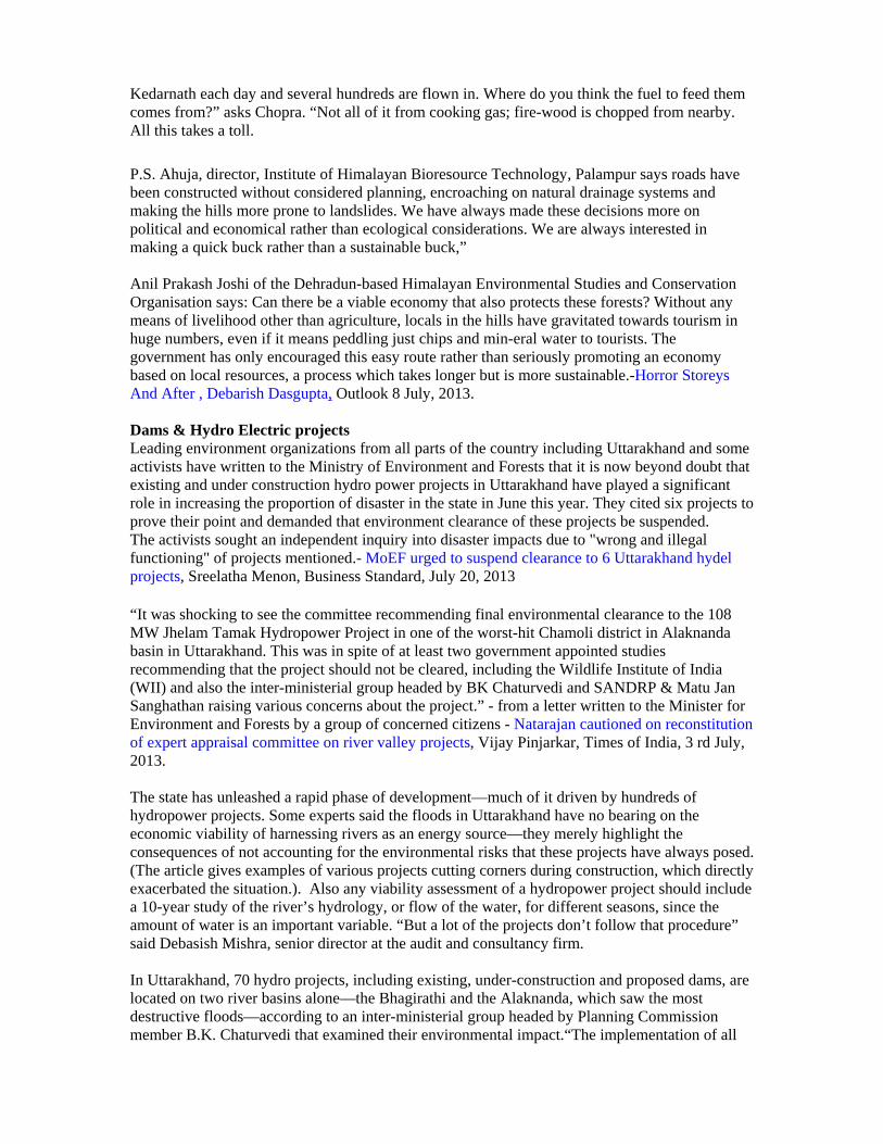
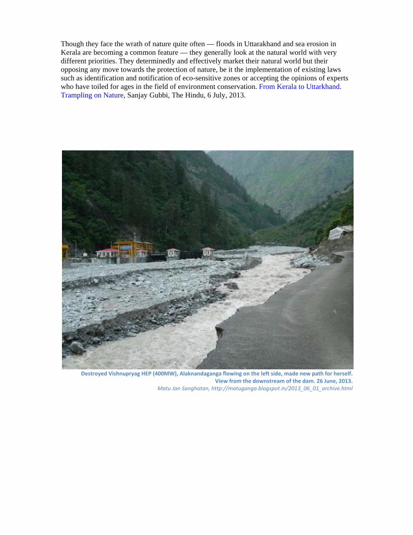
Destroyed Vishnupryag HEP (400MW), Alaknandaganga flowing on the left side, made new path for herself.
View from the downstream of the dam. 26 June, 2013. Matu Jan Sanghatan, http://matuganga.blogspot.in/2013_06_01_archive.html
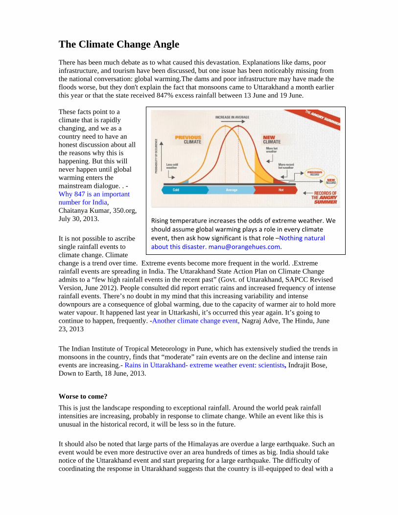
The Climate Change Angle There has been much debate as to what caused this devastation. Explanations like dams, poor infrastructure, and tourism have been discussed, but one issue has been noticeably missing from the national conversation: global warming.The dams and poor infrastructure may have made the floods worse, but they don't explain the fact that monsoons came to Uttarakhand a month earlier this year or that the state received 847% excess rainfall between 13 June and 19 June. These facts point to a climate that is rapidly changing, and we as a country need to have an honest discussion about all the reasons why this is happening. But this will never happen until global warming enters the mainstream dialogue. . - Why 847 is an important number for India, Chaitanya Kumar, 350.org, July 30, 2013. It is not possible to ascribe single rainfall events to climate change. Climate change is a trend over time. Extreme events become more frequent in the world. .Extreme rainfall events are spreading in India. The Uttarakhand State Action Plan on Climate Change admits to a “few high rainfall events in the recent past” (Govt. of Uttarakhand, SAPCC Revised Version, June 2012). People consulted did report erratic rains and increased frequency of intense rainfall events. There’s no doubt in my mind that this increasing variability and intense downpours are a consequence of global warming, due to the capacity of warmer air to hold more water vapour. It happened last year in Uttarkashi, it’s occurred this year again. It’s going to continue to happen, frequently. -Another climate change event, Nagraj Adve, The Hindu, June 23, 2013 The Indian Institute of Tropical Meteorology in Pune, which has extensively studied the trends in monsoons in the country, finds that “moderate” rain events are on the decline and intense rain events are increasing.- Rains in Uttarakhand- extreme weather event: scientists, Indrajit Bose, Down to Earth, 18 June, 2013. Worse to come? This is just the landscape responding to exceptional rainfall. Around the world peak rainfall intensities are increasing, probably in response to climate change. While an event like this is unusual in the historical record, it will be less so in the future. It should also be noted that large parts of the Himalayas are overdue a large earthquake. Such an event would be even more destructive over an area hundreds of times as big. India should take notice of the Uttarakhand event and start preparing for a large earthquake. The difficulty of coordinating the response in Uttarakhand suggests that the country is ill-equipped to deal with a
Rising temperature increases the odds of extreme weather. We should assume global warming plays a role in every climate event, then ask how significant is that role –Nothing natural about this disaster. [email protected].
large earthquake in a mountainous area. The effects would be many times worse. Dave Petley, Wilson Professor of Hazard and Risk at Durham University, UK in and interview with Sheela Bhatt, 'India should start preparing for a large earthquake in Uttarakhand', Rediff.com, July 02, 2013. The Uttarakhand floods illustrated what could happen when an extreme weather event intersects poor mitigation and adaptation practices, ranging from unrestricted logging and construction on landslide-prone slopes to poor disaster management. Environmental mismanagement, too, can accentuate disasters. When natural forests and grasslands of mixed native species are destroyed, degraded, or converted to monoculture plantations of alien species it alters soils, reducing soil moisture retention and infiltration. Uttarakhand and other recent disasters are warnings to us highlighting the need to look beyond just near-term expediency and incorporate greater sensitivity to environment and climate concerns in our best practices across all sectors. Meanwhile, the climate clock is ticking. - Living in an extreme world, TR Ramachandran & TR Shankar Raman, The Hindu, 13 July, 2013 "When a similar disaster struck last year, the state disaster management unit (of Uttarakhand) said in its report that roads and houses were constructed on space encroached from the river, and that such kind of construction should stop. Unfortunately, the government did not take into account its own report. Another problem is, we have not put in place the required infrastructure for predicating the nature’s fury on such a scale. So we are taken by surprise whenever such incidents take place.”- Himanshu Thakkar, SANDRP in “Let the rivers be, and they won’t harm you”, Governance Now, June 20, 2013
India Climate Justice Group demands declaration of stretch from Gaumukh to Uttarkashi as eco-sensitive zone, review dams in the entire Himalayan belt, assessment of the carrying capacity of specific ecosystems extensive and sub-regional warning systems, prior adaptation measures,, retreat to a low carbon pathway of development, revival of local livelihoods and agriculture. - a statement issues by India Climate Justice group June 25, 2013. http://sandrp.wordpress.com/2013/06/25/climate-justice-statement-on-the-uttarakhand-catastrophe/
Disaster Management & Adaptation
The central government of India and various state governments, including the govt of Uttarakhand, have prepared action plans for combating climate change. Any such plan ought to include the establishment of a disaster-prediction and warning mechanism. The Uttarakhand government has taken no measures to prepare for this kind of eventuality, though it has paid lip service to climate action plans over the last three years. Adaptation to disasters does not just mean desperate rescue work during and after the event, but also reducing vulnerability and risk before. Effective adaptation involves a series of measures that need to be adopted on a war footing. The sustainable development of a hill economy, and equity – not profit for a few – should be at its core. The risks faced by marginalized communities in the Himalayas need to be specifically addressed through adaptation measures for (a) reducing vulnerability to major impacts (b) increasing
resilience in the face of environmental changes which affect livelihood and (c) improving the adaptive capacity of the society
a) Vulnerability is reduced by addressing the physical, social, economic, and environmental effects of critical climate change related impacts. These include crop insurance to minimize loss due to crop failure or climate events, early warning system to prevent loss of life in major events, prevention measures to reduce flash floods, and management of water resources.
b) Increasing Resilience: Resilience to climate change can be built up by promoting a) better knowledge of ongoing changes, b) protection of the resource base and preservation of the diversity of crop and livelihood options c) developing diversity of livelihood and d) creating alternative livelihood opportunities is essential if these communities have to preserve their way of life
c) Enhancing Adaptive Capacity: The capacities of the communities to adapt to climate change needs to be enhanced by enabling decision making through better data and information, Supportive systems like crop insurance, enabling micro-level institutions and social networks for finance, knowledge sharing, marketing etc
The Warning & Monitoring Systems
Earth observation satellites provide comprehensive and multi-temporal coverage of large areas in real time and at frequent intervals, which can be used for detailed monitoring, damage assessment, and long-term relief management. However, a system is needed to provide rapid access to earth observation data in a usable form to those on the ground during an emergency. In a voluntary initiative APRSAF (Asia Pacific Regional Space Agency Forum), five countries -- Japan, India, Thailand, Taiwan, and Korea -- are providing earth observation data to Sentinel Asia members during major disasters using locally mirrored servers not only via Internet but also using communications satellites. When a region in the Himalayas asks for support in an emergency, Sentinel Asia would be able to provide appropriate products to a regional knowledge centre in Nepal, which can then forward it to the concerned governments. There is an urgent need to have fully capacitated comprehensive disaster management units that have access to this satellite data and have the capacity to use it. The earth observation would facilitate the monitoring of an event as it unfolds and act as a early warning system to trigger prepared response plans. Enhancing observational and monitoring network, systematic collection of data and information about the Himalayan mountain system is critical for improved understanding of climate change and its impacts and therefore build community resilience around it. The key areas include glaciers and snow cover, snowmelt dynamics and river water flows, water basins and recharge locations, weather and climate trends, land degradation, land use change and energy systems. There is also need for information on critical biological systems like habitats (ecotones, wetlands, alpines, etc.) and species (native, endemic, and economically valuable, etc.), ecosystem structure and its diversity and resilience and ecosystem functions including carbon sequestration and water relations. Data on global trends and well as regional and local trends on each of these areas need to be collated in order to inform adaptation strategies and appropriate development interventions for the benefit of mountain communities in the region.
The earth observation data is important as large areas are inaccessible. Remote sensing data and techniques and geographic information system (GIS) data, complemented by field verification, is an effective method for the mapping and inventorying of glaciers in the region. These methods are being continuously improved and converged, this making comparison and exchange easier. To enhance meteorological observations over the western Himalayas, surface observatories and two upper air stations have been set up. A mountain meteorology program has been started at NCMRWF, the India Meteorological Department (IMD) and the Snow and Avalanche Study Establishment (SASE) at Manali for the purpose of forecasting, providing training and development of snow climatology etc. Currently, mountain weather forecasting over western Himalayas is carried out through a combination of various products viz., regional/ meso-scale model outputs, global model products, in situ observations, and satellite observations along with synoptic conditions by collaborative efforts between National Centre for medium range weather forecasting (NCMRWF), IMD and SASE. It is vital to adequately augment the initiatives for long-term ecological and weather monitoring across the region so as to address the issue of knowledge gaps.
Down to Earth, Oct 1‐15, 2013

Towards a Better Future? As Himalayan communities face such events on a regular basis, there is plethora of local solutions based on indigenous knowledge. These need to be integrated into broader plans. Further these plans should built on and incentivise individual households strategies and the latter should be recognized, promoted and improved upon. All these are essential to create a robust community- based flash flood risk management plan. Such local plans are essential as external help can take several days to reach affected communities and locations. It is therefore essential that community’s capacity to manage the risks from disaster by themselves is strengthened. These include post catastrophe recovery plans, along with awareness raising, public information of emergency plans, drills as well as tools like insurance. Further a decentralized peer to peer network needs to be established based on wi-fi and radio technology to help local groups to take and modify decisions based on unfolding scenarios. The advantage of such systems in non disaster times is that it can be used for communications at low cost between groups of communities, help local groups to take and modify decisions based on unfolding scenarios. Climate Vulnerability in North Western Himalayas, R. Sreedhar, Environics Trust, in Voices of Vulnerability: Choices for Change (Ed) John D’Souza, 2012, INECC. Livelihood resilience people's livelihood resilience depends on how well the community uses the available resources in its adaptive strategies. In agriculture, these include a. Intensification, b. Diversification, c. Value addition, d. Indigenous technical knowledge, e. Marketing, f. Crop cycle management including pre-flood cultivation, cropping with floods (crops which grow well even in floods); and post-flood cultivation (planting late varieties or those which withstand waterlogging). People living in flood stressed zones have their own traditional practices and knowledge that help them to cope effectively. But such knowledge is not given importance by people such as policy makers, or agricultural scientists. Documentation efforts such as this one can assist in making adaptive practices more widely known and valued.
• Opt for just, equitable, democratic and sustainabledevelopment options.
• Panel to decide appropriate development for an eco-sensitive state
• Initiate cumulative impact assessment and carrying capacity studies in each of the basins that would include all development interventions.
• Declare the upper reaches of all rivers as Eco sensitive zone in. Define the path of all rivers and streams and ensure no encroachment there. Remove existing structures in time bound manner.
• No CDMs for hydro above 1 MW. stop work on ongoing projects, suspend their ECs, investigate the role of HEPs through independent committee
• Change EIA notification to ensure EIAs for all hydro above 1 MW . Give communities role in ensuring environment compliance, there is no other way to achieve that.
• No clearances for any more hydro projects above 1 MW till all the steps indicated here are in place.
• Those who are part of the problem cannot be part of the solution: WB, ADB, Developers like GVK, JP, Lanco, L&T, THDC, NHPC, UJVNL…
• Disaster management should start bottom up, and it should have role in all development decision making. Monitoring of glaciers, rainfall measurement in all sub basins.
More broadly, research and extension needs to continue supporting adaptive agriculture. Support at the policy level is also needed, with flood disasters being placed at the centre of development planning and execution. - Adaptive agriculture in flood affected areas by Shiraz Wajih, Leisa India, 24.4, December 2008.
Normally flood prevention programmes involve building large-scale structures like building of embankments, dams, and levees. These have often proven to be disastrous, as when breach occurs, the impact is many times more disastrous. As Himalayan communities face such events on a regular basis, there is plethora of local solutions based on indigenous knowledge. These need to be integrated into broader plans. Further these plans should built on and incentivise individual households strategies and the latter should be recognized, promoted and improved upon. All these are essential to create a robust community-based flash flood risk management plan. Such local plans are essential as external help can take several days to reach affected communities and locations. It is therefore essential that community’s capacity to manage the risks from disaster by themselves is strengthened. These include post catastrophe recovery plans, alongwith awareness raising, public information of emergency plans, drills as well as tools like insurance. - Climate Vulnerability in North Western Himalayas by R. Sreedhar, Environics Trust.
“ The mountain your ancestors brought this far
Every year breaks more and more, like grief All the years all the centuries
Freeze like ice in dreamless eyes In your soul
In the domestic darkness of the hearth Your helpless words are spread
Like grains gathered in a famine.
from `Pahad par Lalten’ by Mangalesh Dabral, a poet from the Garwal mountains
Further Reading: Blog of articles on Climate Change in Mountainous regions in INECC.NET How Uttarakhand is a model of disaster, see: http://tehelka.com/uttarakhand-a-model-of-disaster/ Uttarakhand Disaster: Can the Nation learn any lessons? Transcript of the talk by Himanshu Thakkar, 22 August 2013, Bangalore. Uttarakhand Disaster Mitigation and Management Centre: http://dmmc.uk.gov.in/ Sphere India, coordinating disaster management from non-govt agencies: http://www.sphereindia.org.in/ Raghunandan on Uttarakhand Floods: Causes and administrative culpability in development planning and implementation. Climate Change and India: A 4x4 Assessment - A sectoral and Regional Analysis for 2030s, Indian Network for Climate Change Assessment (INCCA), Ministry of Environment and Forests, 2010. The status of glaciers in the Hindu Kush-Himalayan region, Bajracharya, SR; Shrestha, B (eds), ICIMOD, 2011, Kathmandu.