Embed Size (px)
Citation preview
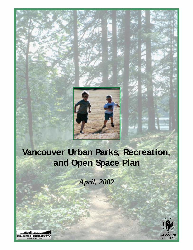
Vancouver Urban Parks, Recreation,and Open Space Plan
April, 2002
- 1 -
Vancouver Urban Parks, Recreation, and Open Space Plan
April 2002
- 2 -
TABLE OF CONTENTS
PREFACE....................................................................................................................................................................4
INTRODUCTION ..........................................................................................................................................................5 Plan Update .........................................................................................................................................................5 Plan Approach .....................................................................................................................................................6
AREA HISTORY..........................................................................................................................................................8
PLANNING AREA .....................................................................................................................................................10 Physical Setting..................................................................................................................................................10 Climate...............................................................................................................................................................11 Topography ........................................................................................................................................................11 Soils....................................................................................................................................................................11 Waterways..........................................................................................................................................................11 Vegetation ..........................................................................................................................................................12 Wildlife...............................................................................................................................................................12 Social & Economic.............................................................................................................................................13
POPULATION............................................................................................................................................................14
PUBLIC INVOLVEMENT.............................................................................................................................................18 Community-Based Plans ....................................................................................................................................18 Public Opinion ...................................................................................................................................................20 Public Meetings..................................................................................................................................................22 Other Public Resources......................................................................................................................................25
GOAL, OBJECTIVES & POLICIES...............................................................................................................................27 Planning Goals ..................................................................................................................................................27 Recreation Policies ............................................................................................................................................28 Special Area & Facilities Policies .....................................................................................................................29 Open Space Policies...........................................................................................................................................31 Trail Policies......................................................................................................................................................34 Conservation & Greenway Area Policies ..........................................................................................................35 Wildlife Habitat Policies ....................................................................................................................................36 Other Policies ....................................................................................................................................................40
DEFINITIONS & STANDARDS.....................................................................................................................................41
EXISTING AREAS & FACILITIES ...............................................................................................................................46 Other Local Facilities ........................................................................................................................................49
DEMAND & NEED ....................................................................................................................................................53 Assessment of Demand & Need..........................................................................................................................53
FINANCING PROGRAMS............................................................................................................................................59 Federal & State Funding Programs...................................................................................................................59 Local Funding Options ......................................................................................................................................63 Incentive Measures ............................................................................................................................................66 Regulatory Measures .........................................................................................................................................67 Other Methods & Funding Sources ...................................................................................................................67
ACTION PLAN ..........................................................................................................................................................70 Urban Parks.......................................................................................................................................................70 Special Areas & Facilities .................................................................................................................................72 Action Plan: Park District #1 (2001-2008).......................................................................................................73
- 3 -
Action Plan: Park District #2 (2001-2008).......................................................................................................75 Action Plan: Park District #3 (2001-2008).......................................................................................................77 Action Plan: Park District #4 (2001-2008).......................................................................................................78 Action Plan: Park District #5 (2001-2008).......................................................................................................79 Action Plan: Park District #6 (2001-2008).......................................................................................................80 Action Plan: Park District #7 (2001-2008).......................................................................................................81 Action Plan: Park District #8 (2001-2008).......................................................................................................83 Action Plan: Park District #9 (2001-2008).......................................................................................................84 Action Plan: Park District #10 (2001-2008).....................................................................................................85
8-YEAR CAPITAL FACILITIES PLAN .........................................................................................................................86
APPENDIX A EVIDENCE OF ADOPTION.....................................................................................................................96
APPENDIX B PARKS INVENTORY..............................................................................................................................97
APPENDIX C RECREATION INVENTORY ..................................................................................................................101
APPENDIX D LIST & DESCRIPTION OF DISTRICT PLANNING AREAS........................................................118
APPENDIX E URBAN PARK AND SCHOOL LANDS INVENTORY METHODOLOGY.................................121
APPENDIX F PARK IMPACT FEE RATE (PIF) UPDATE....................................................................................129
APPENDIX G PARK IMPACT FEE – COST ADJUSTMENT FACTOR ..............................................................140
APPENDIX G PARK IMPACT FEE – COST ADJUSTMENT FACTOR ..............................................................140
APPENDIX H PUBLIC OPINION SURVEY .................................................................................................................153
APPENDIX I SUPPORTING MATERIALS ...................................................................................................................204
APPENDIX J THE BENEFITS MOVEMENT ................................................................................................................226
APPENDIX K VISION 2000 SYMPOSIUM .................................................................................................................230
APPENDIX L CAPITAL FACILITIES PLAN – MAPS..........................................................................................243
APPENDIX M CRITICAL AREA GUIDELINES.............................................................................................................255
- 4 -
PREFACE In 1997, the city of Vancouver and Clark County combined their parks services to create the Vancouver-Clark Parks and Recreation Department. The consolidated department is administered by the city. Services in the unincorporated area, both urban and regional, are provided to the county through interlocal agreement. Due to department consolidation, this plan, for the first time, covers both the incorporated and unincorporated portions of the Vancouver urban area. It was adopted by the both the Vancouver City Council and the Clark County Board of Commissioners. The plan compliments the Regional Parks, Recreation, and Open Space Plan adopted by the county in June 2000.
- 5 -
INTRODUCTION This plan is the road map that will guide Vancouver and Clark County in providing urban parks, open space, and recreation programs for the next six years. It covers the city of Vancouver and unincorporated urban lands within the urban growth boundary. The plan is a component of both the city and county comprehensive land use plans. It also serves as a resource and planning guide for the parks and recreation department. This edition updates and supersedes the city’s former plan that was adopted in 1995 and the county’s former plan that was adopted in 1994. Both park facilities and recreation programs are covered in the plan. While park facilities are examined in detail, recreation programs are addressed generally. Specific goals, objectives, and implementation strategies for the recreation division are included in the 2000 Recreation Program & Cost Recovery Plan.
Plan Update The process of updating the parks plan occurs every six years. This is important for several reasons. Foremost is to ensure that the plan accurately reflects the needs, desires, and priorities of the community. These community-based factors can vary over time with changes in demographics, economics, and society. The recent popularity of skateboarding and the demand for skateboard facilities is a good example. Another reason to update the plan is to remain current with changing conditions. There is no better example of changing conditions than the dramatic changes in the composition of Vancouver and the unincorporated urban area since the last park plan was adopted. Between 1995 and 2000, Vancouver’s population more than doubled from 65,360 to 143,560. In the single annexation of Cascade Park, Vancouver’s city limits grew 60% from approximately 27 square miles to approximately 45 square miles. Meeting the requirements of the 1990 Washington State Growth Management Act (GMA) is a third factor supporting update of the urban plan. Although not a mandatory element, GMA identifies the need for parks and recreation services and facilities in its 13 primary planning goals.
Planning Goals (RCW 36.70A.020): Open Space and Recreation. Encourage the retention of open space and development of recreational opportunities, conserve fish and wildlife habitat, increase access to natural resource lands and water, and develop parks.
Beginning in 2002, GMA will require that cities and counties update their comprehensive land use plans and development regulations at least every five years to ensure compliance with state statutes.
- 6 -
Remaining eligible for grants from the Washington State Interagency Committee for Outdoor Recreation (IAC) is a fourth reason for updating the parks plan. IAC distributes federal and state grant funds to qualified public agencies for the acquisition and development of outdoor recreation facilities. IAC requires that an agency’s parks, recreation, and open space plan meet minimum standards and be updated every six years. During the period between updates, the parks plan is reviewed and adjusted locally to reflect current conditions. The most common mid-term changes in the plan are modifications to the Capital Facilities Plan (CFP) to reflect annual budget allocations and the receipt of federal and state grants.
Plan Approach Two primary methods were used to examine demand and need for urban parks, recreation, and open space: technical analysis and past planning efforts. Technical analysis involves comparing a community vision of park facilities and recreation services that should be provided (demand) against an inventory of current facilities and programs in the urban area (supply). The difference is need (if demand exceeds supply) or unused capacity (if supply exceeds demand). Facilities and services that meet communitywide needs compose one group that is evaluated. Some are facility-based, such as swimming pools. Others are resource-based, such as Burnt Bridge Creek. Facilities that serve local needs are also evaluated, such as community and neighborhood parks. Finally, neighborhood-specific analysis is conducted to evaluate specific sites or areas of need. The local needs met by neighborhood parks, community parks, and urban open space are evaluated using the ten districts created for the collection of park impact fees (PIF). These districts divide the urban area into ten subareas of generally equal size. Three districts are completely within the city, four are completely unincorporated, and three have territory in both the city and the unincorporated urban area1. Past planning efforts are examined and their important work, accomplished by other citizen-based planning efforts, is incorporated into the plan. These include:
• 1992 Clark County Trails and Bikeways System Plan
• 1992 Clark County Open Space Commission Final Report
1 Using this ten-district structure allows the evaluation of needs and the provision of services to more closely reflect the unique characteristics of the neighborhoods that compose the urban area. It also allows the plan to provide the city and county with the same park classifications and the same standards for acquisition and development of parks. This structural uniformity provides the basis for consistent services, and the seamless transition of urban parks and open spaces resulting from annexation. Descriptions of the ten districts can be found in Appendix D.
- 7 -
• 1994 Vancouver Growth Management Plan
• 1994 Clark County Parks, Recreation, and Open Space Plan
• 1995 Vancouver Parks, Recreation, and Open Space Plan
• 1998 Clark County Comprehensive Sports Fields Master Plan
• 1999 Vancouver-Clark Facilities & Services Strategic Plan
• 2000 Clark County Regional Parks, Recreation and Open Space Plan & Urban Wildlife Plan
• 2000 Vancouver Recreation Program & Cost Recovery Plan Together, these two efforts—technical analysis and past planning efforts--create a vibrant, citizen-based plan that meets both the long- and short-term needs of the community.
- 8 -
AREA HISTORY Vancouver and Clark County have a rich and eventful history of recreation that dates back to the early days of Fort Vancouver, around 1826. Journals tell of early trappers and traders competing in contests of marksmanship. Other activities included swimming, boating, skating, picnicking and horseback riding. Reading and conversation were popular pastimes, as were chess, dominoes and cards. And for more social residents, card parties, dances and balls were held. While laying out the city of Vancouver in 1853, Amos Short included a town square. Later known as Esther Short Park, it became the center of social activities, including 4th of July celebrations and community gatherings. By the years leading to World War II, Vancouver's population had grown to 15,000 and the city maintained a park system of some 30 acres and operated a limited summer recreation program. When the war arrived and Vancouver became home to the Kaiser ship yards, the city's population rapidly Vancouver's population soared to 75,000. In response to this rapid growth, the Greater Vancouver Recreation Commission was formed in 1942. At the same time, the Vancouver Housing Authority was successful in securing federal funds to build and operate recreation facilities. In a short time, seven recreation centers were operating 24 hours a day. Following World War II, population declined to about 25,000. Federal funds were no longer available for recreation programs and facilities, although the Vancouver School District and the Greater Vancouver Recreation Commission continued to operate some recreation programs on a reduced scale. Many of the Vancouver Housing Authority's recreation facilities were deeded to the city and the Vancouver School District. In 1951 the Vancouver Parks and Recreation Commission was chartered as the official advisory body for parks and recreation services. Following a study initiated in 1953, the commission recommended that a department of parks and recreation be formed. The Vancouver Parks and Recreation Department was subsequently created by ordinance on March 22, 1955. A budget was allocated and the first director appointed in 1956 to oversee a park system that had grown to about 100 acres. Separately, Clark County formalized its parks program by appointing in 1960 the Clark County Parks and Recreation Board. This board oversees the county’s regional park system, which dates back to 1936/37 when Lewisville Park and Camp Julianna were acquired. Later, in 1972, an administrative director was hired to manage the county’s park system. In the early 1960s a number of neighborhood parks and greenways were created and donated to the city by the Vancouver Housing Authority. David Douglas Park and Marine Park were also purchased, more than doubling Vancouver's recreation areas. In 1965 the citizens of Vancouver passed a bond issue to replace the aging Memorial Center pool. The new Marshall Recreation Center and indoor swimming pool was completed in 1966, welcoming over 200,000 users the first year.
- 9 -
The county’s parks system also grew during the 1960s, primarily through land trades and donations. Most were community- or regional-sized parks, including Hazel Dell, Wintler, Siouxon, Daybreak, Whipple Creek, and a portion of Moulton Falls parks, Another significant addition to the city's recreation system came in the mid-1970s with the construction of a city tennis and racquetball facility. In 1979 the city and Clark County joined to fund the addition of Luepke Senior Center to Marshall Community Center. For the county, the 1970s marked a period of significant regional park acquisition and development, fueled by state and federal grants. In the Vancouver urban area, the Builder’s Program secured sites for future neighborhood parks. In 1985, Conservation Futures was adopted for open space acquisition. Urban park impact fees for neighborhood and community park acquisition were adopted in 1990. A boost to city park funding came in 1980 in the form of a citizen-approved $490,000 bond for park development. With the addition of grant funds, over $1 million in park improvements were completed at Leverich, Waterfront, Marine, Central and Esther Short parks. Other park projects completed during the 1980s included Old Fort Vancouver Apple Tree Park and Waterworks Park. During the 1990s, Vancouver embarked on an ambitious effort to create recreational access along a 12-mile stretch of the Columbia River. Known as the Columbia River Renaissance Project, this effort has already established a four and three-quarter mile pedestrian and bicycle trail along the waterfront in Vancouver, between downtown and Wintler Park.
In 1995/96, the city of Vancouver and Clark County, with the support of the Clark County Home Builders Association, Association of Realtors, and Greater Vancouver Chamber of Commerce, adopted a joint parks plan for the Vancouver urban area. Park impact fees were adopted for acquisition and development of community and neighborhood parks, and for acquisition of urban open space, both inside the city and in the unincorporated urban area. For those park development deficits that could not be addressed by impact fees, the county and city adopted, and dedicated to urban parks for six years, a one-quarter percent real estate excise tax. Under these funding programs, 54 park sites have been acquired and 16 community and neighborhood parks have been developed. Another 13 park sites have been funded through the real estate excise tax and are scheduled for development within the near future.
- 10 -
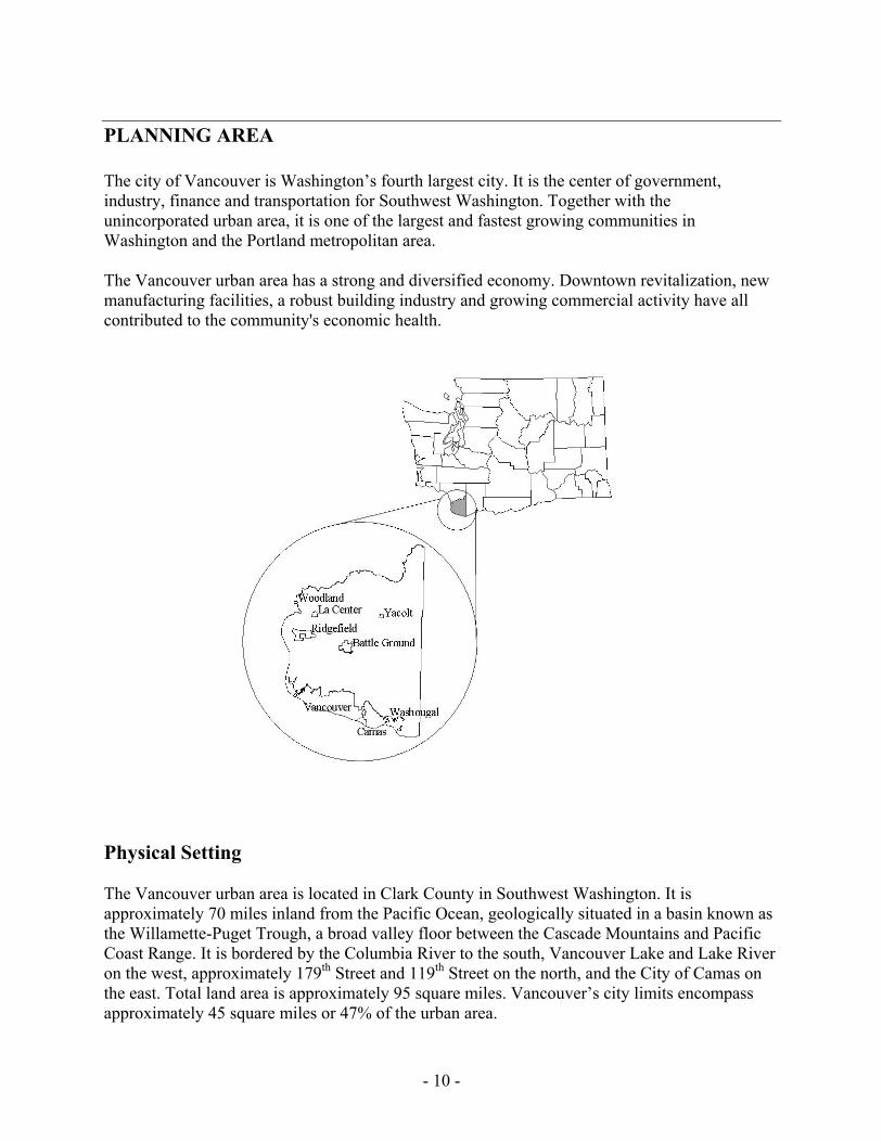
PLANNING AREA The city of Vancouver is Washington’s fourth largest city. It is the center of government, industry, finance and transportation for Southwest Washington. Together with the unincorporated urban area, it is one of the largest and fastest growing communities in Washington and the Portland metropolitan area. The Vancouver urban area has a strong and diversified economy. Downtown revitalization, new manufacturing facilities, a robust building industry and growing commercial activity have all contributed to the community's economic health.
Physical Setting The Vancouver urban area is located in Clark County in Southwest Washington. It is approximately 70 miles inland from the Pacific Ocean, geologically situated in a basin known as the Willamette-Puget Trough, a broad valley floor between the Cascade Mountains and Pacific Coast Range. It is bordered by the Columbia River to the south, Vancouver Lake and Lake River on the west, approximately 179th Street and 119th Street on the north, and the City of Camas on the east. Total land area is approximately 95 square miles. Vancouver’s city limits encompass approximately 45 square miles or 47% of the urban area.
- 11 -
Climate Vancouver and Clark County are located in the West Coast Marine Climate Region that extends along the coast of North America from southeastern Alaska to northern California. This region is influenced by mild, moist air flowing in from the Pacific Ocean. Warm and sunny weather usually prevails in Clark County from June to mid-September. Summer temperatures average about 65 degrees; winter temperatures about 40 degrees. Temperature extremes are not severe. Annual rainfall averages about 37 inches in the Vancouver urban area.
Topography The Vancouver urban area has varying topographic regions. Flood plains and bottomlands along the Columbia River and around Vancouver Lake occupy the southwest corner of the area; slopes can reach as high as 15 percent. Rising in step-like fashion from the Columbia River lowlands is a series of gently rolling alluvial terraces and benches. The highest uplands areas consist of high alluvial terraces that overlook the Columbia River to the south and Mt. St. Helens to the north. This area is one to three miles wide, and in many places has 50- to 100-foot ridges. The highest areas reach an elevation just over 300 feet. Slopes in this area can be quite steep. Two major drainage basins cross the Vancouver urban area. The Burnt Bridge Creek basin runs from east to west through the middle of the area. The creek and its basin originate near the area’s eastern boundary and grow in volume and width, respectively, as they reach their outlet into Vancouver Lake. Similarly, the Salmon Creek basin runs from east to west through the northern portion of the urban area. The creek and its basin originate north of the area and grow in volume and width, respectively, as they reach their outlet into Lake River.
Soils Soils in the Vancouver urban area are generally classified as silt and clay loams. Gravely silt, clay loams, and gravel can be found near the area’s eastern boundary. The Columbia River lowlands have soils that are somewhat poorly to somewhat excessively drained, are moderately coarse to moderately fine textured, and moderately fertile to highly fertile. Detailed information about soils can be found in the United States Department of Agriculture's Soil Survey of Clark County (1972).
Waterways The Vancouver urban area has three major drainage basins: the Columbia River, Burnt Bridge Creek, and Salmon Creek. The Columbia River runs approximately 15 miles along the southern and western boundary of the urban area. It supports commerce, recreation, and serves as important habitat for a variety of fish species.
- 12 -
Burnt Bridge Creek flows approximately 12 miles through the urban area and into Vancouver Lake which drains into Lake River and finally into the Columbia River. Trails, parks, and natural areas are located along the creek. Water quality in the Burnt Bridge Creek/Vancouver Lake drainage basin has seriously deteriorated as a result of problems associated with urban development. Reclamation efforts have been made and further efforts are planned. Salmon Creek enters the Vancouver urban area from the north and flows approximately eight miles to its outlet into Lake River. Trails, parks, and natural areas are located along the creek. Fabled as spawning habitat for salmon so good that you could “walk across the creek on the backs of the salmon,” its water quality has deteriorated as a result of problems associated with urban development.
Vegetation Factors influencing the growth of native vegetation include soil conditions, rainfall, drainage and sunlight exposure. In the Columbia River lowlands, native vegetation consists mostly of willows, cottonwood and native grasses. Upland areas support a mix of deciduous and coniferous tree species. Some of the wetter areas in the uplands are covered with Oregon ash, red alder and water-tolerant grasses, sedges and shrubs. Drier areas support Douglas fir, western red cedar, bigleaf maple, pacific madrona and dogwood, with an understory of salal, ferns, Oregon grape and vine maple.
Wildlife Urban development in and around Vancouver has significantly reduced wildlife populations in the area. However, in some sections of Burnt Bridge Creek, Salmon Creek, the Vancouver Lake lowlands, and in some areas along the Columbia River, important wildlife habitat remains. The Vancouver Lake lowlands within and adjacent to the Vancouver urban area provide particularly rich habitat, including open water, marshes, wetlands and croplands. This area provides resting and nesting grounds for migratory waterfowl, as well as habitat for many species of raptors, waterbirds, shorebirds and songbirds. Species using the lowlands include pheasants, Canada and snow geese, widgeon, mallard, pintail, teal and wood ducks. Sandhill cranes, which are listed as a state endangered species, are fall and spring migrants. Bald eagles and great blue heron use the area for nesting. The concentration and diversity of bird species in the Vancouver Lake lowlands is among the greatest in the county, and many species of mammals, reptiles, and amphibians can also be found. The Columbia River has been identified as a priority habitat area by the state and as critical habitat under the federal Endangered Species Act of 1973. The river drains all or parts of the states of Washington, Oregon, Idaho and Montana and is utilized by many species of anadromous fish as they migrate between spawning areas and the Pacific Ocean. Some of these species are federally listed as endangered or threatened, such as the Snake River sockeye salmon.
- 13 -
The river shore and its natural riparian vegetation provide particularly important habitat for migrating juvenile anadromous fish.
Social & Economic The economy of the Vancouver urban area, along with Clark County as a whole, has been growing steadily as the county’s population has continued to grow at a fast pace. The county’s labor force has been on a rise, increasing from 127,500 in 1990 to 178,300 in 1999. Unemployment rates have consistently hovered around four to seven percent for the past ten years. The economy of the county continues to diversity. Historically, the county depended heavily on resource-based industries such as agriculture, timber, and mining. After 1950, however, heavy manufacturing and then high-tech industries became important components of the county’s economy. Current trends show large employment increases between 1990 and 1998 in transportation and public utilities (96.9%), computer and industrial manufacturing (73.9%), construction and mining (63.5%), and electronics and instruments manufacturing (57.6%). (Population and Economic Handbook, 2000). In terms of educational services, the development of a full service satellite Washington State University Campus has enhanced the availability of higher education in southwest Washington. Located on the northern boundary of Vancouver’s urban area, WSU-Vancouver is the primary provider of junior-senior and graduate level college education. Clark College, located near downtown Vancouver, continues to provide high quality education within the community college system and provides a variety of educational services for the larger county community. Clark County and the southwest Washington region provide a rich diversity of natural features and recreation, historic and cultural opportunities. The county encompasses a variety of local, state, and federal wildlife refuges and conservation and greenway systems, including the Ridgefield and Steigerwald Lake National Wildlife Refuges on the Columbia River. Historic sites of regional and national importance include Fort Vancouver and Officers’ Row, located near downtown Vancouver. The county also encompasses a variety of regional parks, trails, and special facilities that serve a countywide population.
- 14 -
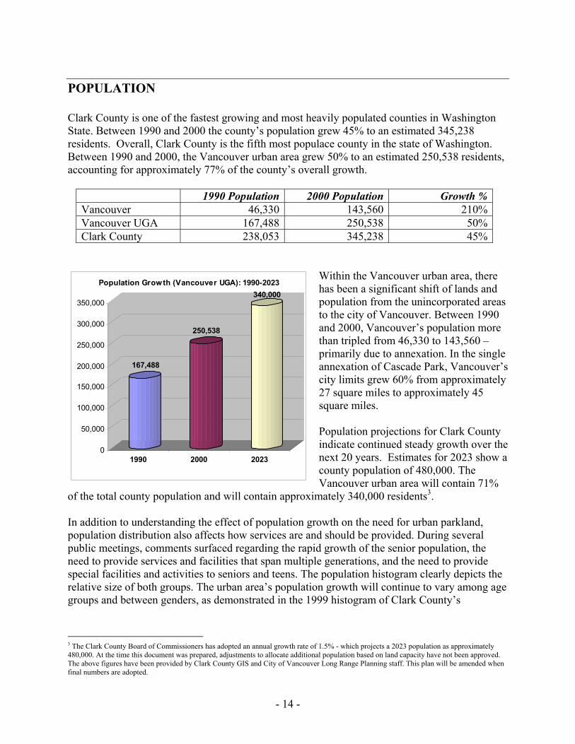
POPULATION Clark County is one of the fastest growing and most heavily populated counties in Washington State. Between 1990 and 2000 the county’s population grew 45% to an estimated 345,238 residents. Overall, Clark County is the fifth most populace county in the state of Washington. Between 1990 and 2000, the Vancouver urban area grew 50% to an estimated 250,538 residents, accounting for approximately 77% of the county’s overall growth.
1990 Population 2000 Population Growth %Vancouver 46,330 143,560 210%Vancouver UGA 167,488 250,538 50%Clark County 238,053 345,238 45%
Within the Vancouver urban area, there has been a significant shift of lands and population from the unincorporated areas to the city of Vancouver. Between 1990 and 2000, Vancouver’s population more than tripled from 46,330 to 143,560 – primarily due to annexation. In the single annexation of Cascade Park, Vancouver’s city limits grew 60% from approximately 27 square miles to approximately 45 square miles. Population projections for Clark County indicate continued steady growth over the next 20 years. Estimates for 2023 show a county population of 480,000. The Vancouver urban area will contain 71%
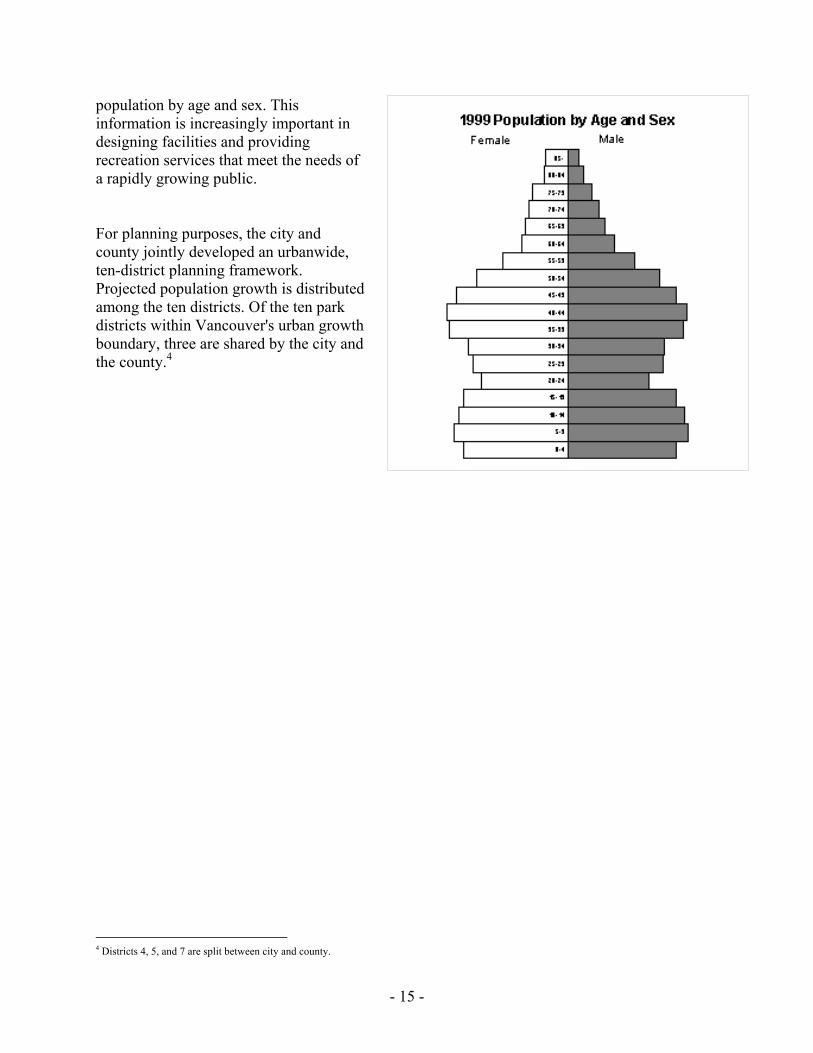
of the total county population and will contain approximately 340,000 residents3. In addition to understanding the effect of population growth on the need for urban parkland, population distribution also affects how services are and should be provided. During several public meetings, comments surfaced regarding the rapid growth of the senior population, the need to provide services and facilities that span multiple generations, and the need to provide special facilities and activities to seniors and teens. The population histogram clearly depicts the relative size of both groups. The urban area’s population growth will continue to vary among age groups and between genders, as demonstrated in the 1999 histogram of Clark County’s
3 The Clark County Board of Commissioners has adopted an annual growth rate of 1.5% - which projects a 2023 population as approximately 480,000. At the time this document was prepared, adjustments to allocate additional population based on land capacity have not been approved. The above figures have been provided by Clark County GIS and City of Vancouver Long Range Planning staff. This plan will be amended when final numbers are adopted.
167,488
250,538
340,000
0
50,000
100,000
150,000
200,000
250,000
300,000
350,000
1990 2000 2023
Population Growth (Vancouver UGA): 1990-2023
- 15 -
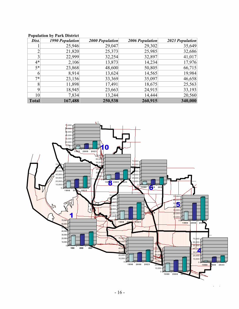
population by age and sex. This information is increasingly important in designing facilities and providing recreation services that meet the needs of a rapidly growing public. For planning purposes, the city and county jointly developed an urbanwide, ten-district planning framework. Projected population growth is distributed among the ten districts. Of the ten park districts within Vancouver's urban growth boundary, three are shared by the city and the county.4
4 Districts 4, 5, and 7 are split between city and county.
- 16 -
Population by Park District Dist. 1990 Population 2000 Population 2006 Population 2023 Population
1 25,946 29,047 29,302 35,6492 21,820 25,373 25,985 32,6863 22,999 32,254 32,897 41,017
4* 2,106 13,873 14,234 17,9765* 23,868 48,600 50,805 66,7156 8,914 13,624 14,565 19,984
7* 23,156 33,369 35,097 46,6588 11,898 17,491 18,675 25,5639 18,945 23,663 24,915 33,193
10 7,834 13,244 14,444 20,560Total 167,488 250,538 260,915 340,000
157
9
23
8 6
4
10
0
10,000
20,000
30,000
40,000
50,000
60,000
70,000
1990 2000 2023
0
10,000
20,000
30,000
40,000
50,000
60,000
70,000
1 9 9 0 2 0 0 0 2 0 2 3
0
10,000
20,000
30,000
40,000
50,000
60,000
70,000
1 9 9 0 2 0 0 0 2 0 2 3
0
10,000
20,000
30,000
40,000
50,000
60,000
70,000
1 9 9 0 2 0 0 0 2 0 2 3
0
10,000
20,000
30,000
40,000
50,000
60,000
70,000
1 9 9 0 2 0 0 0 2 0 2 3
0
10,000
20,000
30,000
40,000
50,000
60,000
70,000
1 9 9 0 2 0 0 0 2 0 2 3
0
10,000
20,000
30,000
40,000
50,000
60,000
70,000
1 9 9 0 2 0 0 0 2 0 2 3
0
10,000
20,000
30,000
40,000
50,000
60,000
70,000
1 9 9 0 2 0 0 0 2 0 2 3
0
10,000
20,000
30,000
40,000
50,000
60,000
70,000
1 9 9 0 2 0 0 0 2 0 2 3
0
10,000
20,000
30,000
40,000
50,000
60,000
70,000
1 9 9 0 2 0 0 0 2 0 2 3

- 17 -
- 18 -
PUBLIC INVOLVEMENT Opportunities for public involvement in developing this plan were extensive. Three primary methods were used: 1) review of nine citizen-based planning efforts conducted between 1989 and 2000; 2) a public opinion survey completed in January 2001; and 3) community meetings and stakeholder interviews conducted during May and June 2001. Other opportunities for public input included email, an Internet web site, and Parks information table at community festivals and events. The SEPA environmental review process allowed the public time to review and comment on the draft plan. Public workshops and hearings were held with the Vancouver-Clark Parks and Recreation Advisory Commission, the Vancouver Planning Commission, the Clark County Planning Commission, and the Clark County Board of Commissioners, and the Vancouver City Council.
Community-Based Plans The nine plans reviewed in this section are community-based plans. Their development involved public input and participation, and their implementation has received community support.
1992 Clark County Trails & Bikeway System Plan The countywide trails and bikeway plan was prepared under the guidance of and with input from a 15-member task force of private and public agencies and interested citizens. Task force membership included representatives from bicycle, walking, and equestrian clubs, and providers of trails on public lands, including the US Fish & Wildlife Service, US Forest Service, and Washington Departments of Fisheries, Wildlife, Transportation, and Natural Resources. Additional information was gathered during two series of public workshops. The plan covers incorporated and unincorporated areas and identifies five trail types: regional multi-use trails, local trails, rustic trails, semi-primitive trails, and bike lanes and pedestrian walkways. Published in December 1992 and adopted by the Board of County Commissioners in September 1993, the Clark County Trails & Bikeway System Plan establishes nine general and 31 specific planning policies to guide the acquisition, design, and development of trails and bikeways. The complete trails and bikeway plan is incorporated by reference.
1992 Clark County Open Space Commission Final Report The 14-member Clark County Open Space Commission was organized in November 1989 to prepare an open space plan for the county. Following three years of work, which included a citizen survey in June 1991, the commission issued its final report in August 1992. The commission's report has served as the primary guide in planning and acquiring the growing system of open space, greenways, and habitat areas throughout Clark County. The Clark County Open Space Commission Final Report is incorporated by reference.
- 19 -
1994 Vancouver/Clark County 20-Year Comprehensive Growth Management Plan Vancouver’s current land use plan was prepared under the requirements of the Growth Management Act. Working with Clark County, the planning process began in October 1991 with development of the Community Framework Plan—a vision of what the county should look like in 50 years. This was followed by preparation of the 20-Year comprehensive land use plan, which was adopted in 1994. Both processes were structured to maximize public input. Opportunities for citizens to learn about and participate in the planning process were extensive. They included a steering committee composed of all city mayors and the county commissioners, a technical advisory committee, and issue-based subcommittees, including one on parks. A comprehensive public information program was also implemented, including newsletters, speakers, a telephone “hotline,” programming on city-county television, and periodic progress reports mailed to all county residents. Other opportunities for citizen participation included eight visioning workshops, five planning fairs, planning workshops, a lecture series, and a countywide public opinion survey conducted in 1992.
1994 Clark County Parks, Recreation & Open Space Plan The 1994 Parks, Recreation & Open Space Plan was the county’s first parks plan developed under the requirements of the Growth Management Act. Under GMA, preparation of the parks plan was incorporated into the overall land use planning process. This included participation in an extensive public outreach program involving 19 public workshops held throughout the county, a public opinion survey, community outreach, and citizen and agency advisory boards. The county parks department also sponsored opportunities for public input and involvement, including two public opinion surveys — the June1991 open space survey and the March 1992 parks survey — six special citizen committees, and 10 special interest group meetings. Since adoption, the plan has served as the county’s policy guide for acquisition and development of urban and regional parks and facilities.
1995 Vancouver Parks Recreation, and Open Space Plan This plan was completed in April 1995. Like Clark County, it was the city’s first park plan developed under the Growth Management Act. Significant public participation was provided through city and county efforts to involve the community in implementation of GMA. Public workshops, public opinion surveys, printed materials, community outreach, and citizen and agency advisory boards all contributed to the public’s knowledge of and participation in the planning process.
1998 Clark County Sports Field Master Plan The Clark County Sports Field Master Plan was published in January 1998. It was developed under the guidance of two community-based committees. A 16-member citizen task force represented user groups. It was composed of representatives of baseball, softball, soccer, and football at the adult, teen, and youth levels. Invitations to participate were sent to 42 leagues. A 13-member administrative task force represented sport field providers. It included members from cities, schools, and Clark County.
- 20 -
The plan includes goals for cities, schools, user groups, and the county. The complete sports fields plan is incorporated by reference.
2000 Clark County Regional Parks, Recreation, and Open Space Plan The county’s regional parks plan was adopted in June 2000. It covers regional parks, trails, recreation facilities, and open space. The planning process involved a statistically reliable citizen survey, mail-in and Internet surveys, five public meetings, stakeholder interviews, a citizen-sponsored parks symposium, and public review and adoption. Six major goals and 94 policies help define the county’s roles in urban and regional facilities.
1999 Vancouver-Clark Facilities & Services Strategic Plan This study examines the facilities and services in the Vancouver urban area. It was completed with the objective of providing better recreation services to the community. The plan creates seven strategic initiatives to be accomplished within three to five years. Seventeen implementation strategies are identified as action guidelines for achieving the goals. This plan was completed with the assistance of the citizen-based Vancouver-Clark Parks and Recreation Commission and in consultation with local school districts.
2000 Vancouver-Clark Recreation Program Cost Recovery Plan This July 2000 plan covers the vision and guiding principles for recreation services in Vancouver. It includes six major goals based on citywide strategic commitments and department-wide strategic initiatives. Programming objectives and priorities are provided for each of five age groups. An implementation strategy identifies key activities to achieve the plan’s goals and objectives. The citizen-based parks and recreation commission assisted with development of the plan.
Public Opinion Several methods were employed to allow the public the opportunity to provide information and express opinions about the needs and priorities for urban parks, recreation and open space facilities and programs in the Vancouver Urban Growth Area. The results of these efforts played an important role in preparing and prioritizing the capital facilities plan.
Community Survey Vancouver-Clark Parks and Recreation retained Intercept Research Corporation of Tigard, Oregon, to conduct a statistically reliable assessment of citizen’s attitudes and opinions about parks, recreation, and open space facilities and services. Telephone interviews were conducted with 600 randomly selected residents throughout the Vancouver Urban Area during December 2000 and January 2001. The 600-person sample was also segmented into three equal geographic regions: west Vancouver, east Vancouver, and the unincorporated area within the UGA. (Complete survey results can be found in Appendix H.)
- 21 -
Survey Results Children’s activities, such as supervised playgrounds, after-school and summer activities, and sports activities, were rated in the survey as the most important recreation programs in need of expansion (49%). Teen activities were rated second (42%), followed by recreational and cultural activities for individuals with disabilities (39%). Remaining programs included aquatic programs (35%), special events (31%), senior citizens’ activities (27%), adult activities (17%), and adult sports leagues (14%). When the responses of “expanding and “maintaining” service levels are combined, each one of the activities has between 76% and 86% support. When those who support expansion were asked if they would pay additional taxes or user fees, all but one activity received 80% or higher affirmative response. When asked which recreational and cultural activities they conducted outside the county, 15% of those responding identified hiking/walking. Camping/backpacking and performing arts both had 12% leaving the county, and both concerts and skiing/snow sports were 10%. This correlates with countywide recreation surveys conducted in 1992 and 1999 that show hiking/walking as the most popular recreation activity, followed by picnicking, wildlife observation, camping, and swimming. Forty percent responded that there were no recreation activities that required them to leave the county. Those respondents who leave the county cited no availability (45%) and better quantity and quality of recreational/cultural activities elsewhere (37%) as their reasons for leaving. Those responding to the survey rated children’s playground equipment the most important facility in neighborhood and community parks (71%). Open lawn areas (59%), asphalt walking paths (58%), and picnic facilities (57%) followed in order. Purchasing natural areas, such as wetlands and forests, was rated very important by 44% and important by 16% of those responding to the survey. Preserving and replacing street trees also received support as important and very important with 41% and 25%, respectively. When faced with five alternatives concerning the rate of park development, respondents gave their highest support to developing parks within five years of land acquisition (49%), followed by immediate development (30%). Rating the importance of special facilities and programs resulted in outdoor tournament sports complexes rated the most important at 45% followed by community gardens (36%), bicycling-motocross facilities (34%), dog parks (28%), skate parks (28%), boat launches (25%), and tennis courts (18%). Interestingly, sports complexes rate as the most important special facility, yet earlier adult sports leagues rated the lowest in support for expansion. Trails along the Columbia River, Burnt Bridge Creek, and Salmon Creek were rated as the most important type of trails (55%), followed by rustic trails (50%), and trails connecting parks and schools (46%). Support for using schools to adequately serve park needs in neighborhoods without available land was fairly mixed, with strong agreement (21%) slightly outweighing strong disagreement (15%).
- 22 -
Sport field development options received fairly uniform support among alternatives. Land banking received 39% support; acquiring and developing with unknown maintenance funding received 38% support; and full public acquisition, development, and maintenance received 35% support. Overall safety and security was rated highest in recreation facilities (48% good or excellent) and lowest on trails (26% good or excellent). When asked if higher taxes would be acceptable to improve safety and security, those who rated facility types fair or poor supported higher taxes for trail safety (62%), neighborhood and community park safety (55%), and recreation facility safety (52%). Upkeep of neighborhood and community parks was seen as good or excellent by 64% of respondents. Leverich Park was identified most frequently as needing additional maintenance. And of those who responded that upkeep was fair or poor, trash/litter, poor facility upkeep, and inadequate or neglected playground equipment were most often mentioned.
The Internet Vancouver-Clark Parks and Recreation created, and the city of Vancouver hosted, an Internet web page dedicated to the comprehensive parks plan update. (Clark County provided a direct link from their site.) Information about the planning process was posted on the site, and citizens were encouraged to use the site to submit concerns and raise issues relating to the plan. Additionally, text of the draft plan and the executive summary of the survey were posted on the site.
Public Meetings Thirteen public meetings were held at locations throughout the Vancouver urban area during May and June 2001 to allow citizens the opportunity to ask questions, submit ideas, and make recommendations about the future of the urban system of parks, open spaces, and recreation services. “Stakeholder” meetings were held with individuals in the community who have a particular interest or knowledge of parks and recreation in the Vancouver urban area.
Neighborhood Meetings Neighborhood meetings were held in each of the ten park service districts covering the Vancouver UGA. Meetings were also held for urbanwide input, local government television (CVTV), and for individuals supporting a park where unleashed dogs would be allowed. These meetings were advertised with public notices, paid advertisements, direct mail to neighborhood associations and churches, school flyers, and school newsletters. One additional meeting was held at the request of the Hazel Dell Neighborhood Association. Neighborhood Parks – There was general consensus at each of the neighborhood meetings that small parks serving neighborhoods—those parks within walking distance without crossing a busy street—are the most important. There was a desire that acquired sites be developed soon, without another group of children and parents missing the opportunity to use them. Older parks should be brought up to standard.
- 23 -
Activities for Children – Children’s activities were frequently mentioned as the most needed and important element of a recreation program; affordable activities for children and their families, in Clark County, preferably in the neighborhoods. Recreation facilities, such as community centers, and recreation programs, such as supervised after-school and summer playground activities, were both mentioned. Activities for Teens – Safe activities for teens was another need expressed at the neighborhood meetings; providing opportunities for teens to be with friends in a drug- and alcohol-free environment. For example, roads in many developments are lined with personal basketball hoops with children and teens playing games in the streets because of a lack of available public facilities. Schools As Parks – Opinions about the value of schools in fulfilling the need for parks fell into three categories. One group acknowledges that schools are used for recreation, but believes they are supplemental to the core park system and should not be counted in the urban inventory. The second group supports the use of schools for recreation purposes, believes improvements to adjoining and/or school grounds are a good investment, and is satisfied with current inventory methodology. The final group believes that a school site is the same as a park and should be fully counted in the urban park inventory. Drainage Areas As Parks – At several neighborhood meetings criticism was expressed that fenced drainage facilities are being mapped and counted as parks. While they provide some open space value, they are inaccessible and provide no recreational value. Individuals expressed the need to provide access to these sites by removing the fences. Trails/Walking – Trails for year-around walking, jogging, and cycling were supported as a high priority for facility development. This includes completing and connecting trails to build a community network that provides access to and from neighborhoods. Examples of successful trails in the urban area include Burnt Bridge Creek, Salmon Creek, and the Columbia River Renaissance trails. The need to connect the Salmon Creek Trail with a trail around Vancouver Lake was also expressed. Community Centers/Pools – The need for a coordinated system of swimming pools and community centers in the Vancouver urban area was raised at most meetings. The areas most often suggested as having the greatest need were the east urban area (Cascade Park) and the north urban area (Hazel Dell/Salmon Creek). Dog Parks – There was organized and energetic expression of the need for a place where owners can take their dogs to run off leash. About 60 people attended a meeting to discuss the issue. A committee was formed to look for ways to meet this need. Skateboard Facilities – A recurring topic at the neighborhood meetings was the need for a “skateboard park” and/or skateboard facilities in existing parks. The need for and advantages of such facilities was well articulated by skateboarders themselves and their parents. Participants must often go to Portland to find adequate facilities.
- 24 -
Natural Areas – The importance of retaining open space in the urban area was discussed at several meetings. The need to develop less of each park and leave more habitat was expressed. Limiting the use of pesticides and herbicides and better signage were also recommended. Improving access and usability of natural areas was also suggested. Park Site Amenities – For those neighborhoods with developed or partially developed parks, the need for additional recreational amenities was expressed. These amenities include wading pools, park benches, walking paths, multi-purpose sports field, and outdoor sports courts. Partnerships & Volunteers – When faced with a lack of facility development due to unfunded maintenance costs, individuals and neighborhoods suggested building partnerships that allow them to maintain all or parts their neighborhood park. This occurred most often in the unincorporated urban area where the county allows little park development. Other partnerships recommended include working with the YMCA, Boy’s and Girl’s Clubs, and school districts to coordinate recreation programming and use of recreation facilities.
Stakeholder Interviews Interviews were held with individuals, agencies and representatives of groups who have a direct interest in the urban parks plan and the services and facilities it addresses. Information gathered from these interviews provided an important perspective of the community’s parks and open space needs. The interview process also offered an opportunity to discuss service delivery, partnership opportunities, and project and program priorities. Interviews included representatives from local agencies that provide parks and open space facilities in the Vancouver urban area, schools, local law enforcement, and special interest groups that focus on land preservation, business, and commercial development. While the opinions and observations of the stakeholders varied widely, three general themes emerged: prioritization, utilization, and partnerships. Prioritization – The Vancouver-Clark Parks and Recreation Department must better prioritize it needs for funding and implementing capital facilities. Recent changes in state law have limited public resources available for local agencies to spend on government services. Now, more than ever, the parks department must look for new ways to fund its services. And proposals for capital projects must be well prepared and properly timed, both internally and within the parent organizations. Utilization – Existing public facilities and resources need to be better utilized. This could include expanding and promoting public use of school facilities, using volunteers for park security, seeking changes in state laws that limit revenue use, and leveraging existing revenue. Partnerships – Developing partnerships with other government agencies, nonprofit organizations, and the private sector will be a critical component of the delivery of park and recreation services for the foreseeable future. Partnerships could be formed with:
- 25 -
• Schools districts for co-developing and jointly operating recreation facilities, such as building or improving sports fields on school property
• Private non-profit organizations for developing and operating facilities and coordinating recreation programs
• Neighborhoods for developing and maintaining neighborhood parks • Law enforcement to focus resources on specific problems • Social services agencies to coordinate the provision and distribution of services, and the
placement, funding, and utilization of capital facilities Clarifying the different roles and responsibilities of the city and the county in the urban area, rethinking the adequacy of the current goals and standards, and better informing the public of the rationale behind the roles, responsibilities, goals, and standards were all mentioned.
Public Review & Adoption Process In addition to the public’s participation in developing the urban parks and open space plan, six opportunities to influence the completed plan were provided. The State Environmental Policy Act (SEPA) establishes guidelines and procedures for determining if a proposed action, such as the adoption of a comprehensive parks and open space plan, has significant, adverse environmental impacts. These procedures include public and agency notification of proposed actions and opportunities for public comment. This plan was reviewed under SEPA. Locally, the public review and adoption process provided several opportunities for public input and comment. The plan was reviewed first by the citizen-based Vancouver-Clark Parks & Recreation Advisory Commission. The commission’s meetings were open to the public. The plan was next reviewed by the Clark County Planning Commission and the Vancouver Planning Commission. The commissions’ meetings and hearings were open to the public and opportunities for public comment were provided. Finally, the Clark County Board of Commissioners and the Vancouver City Council considered and adopted the plan. Board and council meetings and hearings are open to the pubic.
Other Public Resources
Vision 2000 Symposium The “Vision 2000” open space planning symposium was held in Vancouver on March 23, 2000. More than 200 Vancouver and Clark County residents participated in the event. Individually and in groups, participants shared ideas and developed plans for the future of open space in Clark County over the next 50 to 100 years. The ideas and suggestions generated at the symposium are contained in the report “Framing a Community Vision for Open Space in Vancouver and Clark County.” The report provides a broad framework for open space planning and addresses the major areas of trails, wildlife habitat, urban parks, urban density, views and vistas, and community landscaping/vegetation.
- 26 -
Telephone, Internet, Regular Mail and email Four additional ways to submit input were widely advertised: telephone, internet web site, regular mail, and email. Handouts and publications used during the planning process included the telephone number and mail and email addresses of the staff member in charge of the project. An internet web site was designed specifically for this urban parks plan. The site contained an overview of the planning process and timeline, background material and information regarding specific topics and elements of the plan, links to public meeting dates and locations, copies of the draft plan and SEPA checklist, and a comment/response form. Although few in number, responses by telephone and mail provided an important source of detailed information for use in developing the parks plan.
- 27 -
GOAL, OBJECTIVES & POLICIES With the adoption of the Growth Management Act in 1990, the Washington State Legislature prescribed land use planning guidelines for selected cities and counties in the state, including Clark County and the city of Vancouver. The Legislature identified 13 planning goals to guide the development of comprehensive plans and development regulations (now codified in Chapter 36.70A of the Revised Code of Washington). Three of these goals directly affect the development and implementation of this plan. RCW 36.70A.020(9) covers parks, recreation, and open space:
“Encourage the retention of open space and development of recreational opportunities, conserve fish and wildlife habitat, increase access to natural resource lands and water, and develop parks.”
RCW 36.70A.020(10) covers the environment:
“Protect the environment and enhance the state’s high quality of life, including air and water quality, and the availability of water.”
RCW 36.70A.020(13) covers historic preservation:
“Identify and encourage the preservation of lands, sites, and structures, that have historical or archeological significance.”
Planning Goals The goals listed in this section apply to the general implementation of the urban parks system. Goals for acquisition, development, and management of the regional parks system are identified in the Clark County Regional Comprehensive Parks, Recreation and Open Space Plan adopted in June 2000. In implementing the urban system, Vancouver-Clark Parks and Recreation shall be guided by the following goals, objectives, and policies.
• Provide a balanced park and recreation system available to all segments of the community, serving varying geographical differences, regardless of ability. Individuals and groups should be able to use and be encouraged to use all programs and facilities.
• Provide a parks, recreation and open space system that is efficient to administer and maintain.
• Cooperate with other municipalities, state and federal agencies, school districts, nonprofit organizations, and the private sector in fulfilling the recreational and open space needs of the urban area, where possible, in conformance with standards adopted in the Americans with Disabilities Act.
• Establish a process for continuing communication and cooperation between service providers to ensure delivery of effective and efficient services.
- 28 -
• Develop and maintain a plan that assists the city and county in obtaining funds for sound capital improvements, maintenance and operational support.
• Utilize available resources to implement the plan, including impact fees as a source of funding for capital projects directly attributable to new development. Other sources to be pursued include federal and state funding, trust funds, dedicated taxes, local improvement districts, donations, and user fees.
• Consider alternatives in governmental structure and funding for providing park and recreation services, including the creation of special-purpose districts, such as a park and recreation district or a metropolitan park district.
• Give special consideration to archaeological resources, unique sites, water quality and habitat protection, and views and vistas when acquiring or otherwise protecting open space/parklands and recreational facilities.
• Give special attention to new and existing school sites to accommodate neighborhood recreation needs, including evening and weekend recreational opportunities, through shared resources, acquisitions, site redesign, and enhancements.
• Incorporate historically significant sites into the park, recreation and open space system for the promotion of tourism and major regional and cultural events.
Recreation Policies Vancouver-Clark Parks and Recreation has adopted three plans that guide the provision of recreation services: the 1999 Facilities and Services Strategic Plan, the 2000 Civic Campus Master Plan for East Vancouver, and the 2000 Recreation Program Cost Recovery Plan. These plans are based on seven strategic initiatives and 17 implementation strategies. These three documents are incorporated herein by reference and shall guide the provision of recreation services in the urban area. Strategic Initiative #1 -- Enhance parks, recreation and cultural services through quality management and effective communication. Strategic Initiative #2 -- Build and foster meaningful public and private partnerships in our community. Strategic Initiative #3 -- Through public process and dialogue, encourage and accommodate citizen participation in parks, recreation and cultural services. Strategic Initiative #4 -- Ensure equitable distribution of services throughout the community. Strategic Initiative #5 -- Provide comprehensive parks, recreation and cultural systems throughout the community. Strategic Initiative #6 -- Advocate responsible stewardship of natural resources.
- 29 -
Strategic Initiative #7 -- Develop opportunities for parks, recreation and cultural services to be less dependent on general fund dollars.
Other Recreation Policies
• Deliver recreation and leisure services that meet one or more of the department’s strategic initiatives.
• Deliver a mix of recreation and leisure services at the community and neighborhood levels that, in combination, meet all of the department’s strategic initiatives.
• Deliver recreation and leisure services as close as possible to the neighborhood level; that is, they should be decentralized and as close to the user as possible.
• Plan and deliver recreation and leisure services with consideration to accessibility. These services should maximize opportunities for social interaction.
• Establish recreational programs which use public park and recreation facilities.
• Coordinate parks and recreation resources and programs with schools through interagency agreements.
• Encourage the establishment of special interest organizations to help promote and program specific activities, such as walking clubs, wellness events and bicycle clubs.
Special Area & Facilities Policies
General Policies • Develop minimum standards and level-of-service thresholds for parks and recreation
facilities, develop parks within walking distance of each neighborhood, and develop a variety of public recreational facilities including but not limited to community centers, swimming pools, playgrounds, sports facilities, teen centers, golf courses and art centers.
• Develop special facilities to accommodate specific activities, such as water access areas, nature interpretation sites, amphitheaters, gardens and skate board parks.
• Increase public awareness of the area's cultural and historic resources, their significance, and programs for their preservation and management.
Sports Fields Master Plan The Clark County Sports Field Master Plan was published in January 1998. The plan evaluates seven sports field categories: teen/adult baseball, youth baseball, adult softball, youth softball, teen/adult soccer, youth soccer, and football. The plan calls for the county to join with cities, school districts, and local sports organizations to jointly implement a system of sports fields and complexes. The plan also provides recommended
- 30 -
policies and actions to build and improve sports fields. They are divided into five categories: administration and management, development, maintenance, funding, field recommendations. These recommended policies and actions, and the roles and responsibilities they involve, have not been formally adopted or assumed by the school districts or municipalities in the county. The recommendations are summarized below. • Overall planning and assessment of sports field needs in Clark County is a regional
responsibility. This includes re-evaluation of field inventories and assessments every five years as part of the county’s comprehensive parks plan update. Municipal comprehensive plans address existing and future needs within the jurisdiction and should be updated every five years.
• Acquiring, developing, maintaining, and scheduling sports field facilities is the primary responsibility of municipalities, school districts, and private organizations. The county assists with land acquisition, particularly for regional sports field complexes (for which land should be secured immediately). The county provides design and technical support services.
• All organizations adopt countywide design standards for field construction, as well as common service levels for the allocation of play and practice. Fields are scheduled to the same teams every year. School districts establish minimum standards for construction of athletic fields at new schools.
• Cities join with the county and other affected groups to form a county sports council to manage all sports facilities in Clark County. The council helps develop countywide design standards. Cities and private organizations coordinate their efforts with schools to ensure that design standards are met. The plan recommends that the county hire for one year a sports council coordinator.
• Municipal agencies promote the development of athletic fields in new parks, particularly in larger community parks and regional parks. Highest priority is given to upgrading substandard fields, funded through participant fees. The preferred method of developing fields is through private groups.
• Minimum maintenance standards are developed, and field rest and rotation schedules are established. Private organizations and school districts contract services with Clark County or cities.
The plan evaluates the need for each type of sports field, and an approach to meeting the need is offered on a field-by-field basis. Four alternative financing strategies are offered: land acquisition only; renovating fields; major acquisition and development; and minimal field construction as part of park development. The Clark County Sports Field Master Plan provides valuable information, policy recommendations, and implementation strategies. It shall be used by Vancouver and Clark County as a guide in planning and developing sports fields within the urban area.
- 31 -
Open Space Policies
Open Space Commission Final Report The Clark County Open Space Commission Final Report was completed in August 1992, and has been used extensively to guide the establishment of a conservation and greenway system in Clark County. The report creates five categories of open space: river systems and associated flood plains; Columbia River lowlands; agricultural lands; forest lands; and urban open space. The report also establishes 13 general planning policies to guide the evaluation and prioritization of open space lands, and establishes category-specific planning policies. The general planning policies are stated below (references to Clark County have been changed to Vancouver-Clark Parks & Recreation). Additional open space policies have been added, based in part on the category-specific policies listed in the Open Space Commission Report. The Clark County Open Space Commission Final Report is incorporated herein by reference and shall guide Vancouver-Clark Parks & Recreation in establishing a system of open space lands.
General Policies • Consider acquiring open space lands where there is a high probability of loss or conversion
before acquiring open space lands where there is a low probability of loss or conversion. This should take into consideration both actual development and property division and ownership patterns.
• Give added consideration to open space lands which enhance the value of other protected abutting or neighboring parks, forest, wildlife preserves, natural areas, or other open spaces.
• Give added consideration to open space lands where existing access facilities are appropriate for the character of the property, or where the possibility exists to provide access facilities which are appropriate for the character of the property.
• Preserve and protect open space lands based on location of the resource, rather than on a uniform distribution throughout the county. However, in the specific case of neighborhood parks, community parks, and urban open space, Clark County [Vancouver] has existing standards which should be used to determine distribution.
• Where appropriate, attempt to link open space lands into an interconnected system.
• Generally emphasize the preservation of large contiguous blocks of open space. In certain circumstances, however, it may be appropriate to acquire smaller unconnected tracks, e.g., urban open space or the last available piece of open space of a certain category or function.
- 32 -
• Preserve the character of natural areas containing threatened or endangered plant or animal habitat.
• When acquiring or otherwise protecting open space lands, give special consideration to archeological and historical resources, unique sites, and views and vistas.
• When acquiring open space lands of similar character, emphasize the preservation of those lands which are in closest proximity to the largest number of users.
• Coordinate efforts to protect open space lands with local, state, regional, and federal agencies to complement acquisition programs and maximize resource potential.
• Consider relevant state policies and guidelines including those set forth in the Growth Management Act.
• Take into consideration the economic impact and future well-being of the community when implementing the open space program.
• Fully implement the parks and recreation element of Clark County's [Vancouver’s] 20-year plan.
Other Open Space Policies • Identify, evaluate, and prioritize for acquisition and/or preservation lands that create an
interconnected system of open spaces.
• When acquiring park and open space lands with forest tracts or significant wooded areas, consider assessing the health and conservation capacity of these areas for use in master planning.
• Vancouver-Clark Parks & Recreation should establish a system of urban buffers which separates neighborhoods and communities; where natural buffers, such as streams, do not exist, the acquisition of buffers should still occur, where possible.
• Vancouver-Clark Parks & Recreation should meet or exceed the standards set forth for urban parks and open space and should implement the urban parks component of the parks and recreation element of the county’s [city’s] comprehensive plan.
• Vancouver-Clark Parks & Recreation should enhance landscaping within the urban area as follows:
A. Develop and meet standards for landscaping raised medians on county [city] arterials.
B. Enhance and meet standards for landscape buffers adjacent to major roadways, within commercial and high-density residential areas, and between these areas and lower-
- 33 -
density areas such as single-family neighborhoods, schools, parks and designated urban open spaces.
C. Maintain the street tree program to plan, promote and manage the planting and care of trees along or within public road rights-of-way.
D. Within the City limits, comply with the tree retention, protection and density
requirements as outlined in the Vancouver Tree Conservation Ordinance (VMC 20.96).
• Vancouver-Clark Parks & Recreation should preserve or encourage the preservation of forested or other small-scale non-recreational open space lands in the urban area, in which the elements include understory native vegetation. The city shall comply with appropriate urban forestry practices including those outlined in the Vancouver Urban Forestry Manual (VMC 20.96).
• Vancouver-Clark Parks & Recreation should continue to encourage and facilitate the use of other publicly-owned property as open space, such as schools, universities, power transmission lines, etc.
• Vancouver-Clark Parks & Recreation should encourage and provide public access to the Columbia River and other shorelines within the urban area, where appropriate.
• Identify open space corridors and areas, which shall include lands useful for parks and
recreation, fish and wildlife habitat, trails, public access to natural resource lands and water, and protection of critical areas and water quality. Wherever possible, the natural terrain, drainage and vegetation of the community should be preserved with high quality examples contained within parks or greenbelts.
• Maintain, preserve, enhance and reinforce the desirable and distinctive characteristics of the community and its individual neighborhoods while strengthening its sense of place.
• Promote landscaping and tree planting along transportation routes and throughout the urban area. Encourage the development of rooftop gardens on multistory buildings to reduce radiant heat and provide additional greenspaces for occupants. Support an active urban forestry program where appropriate as outlined in the Urban Forestry Work Plan.
• Provide a continuous system of openspace/wildlife corridors to be determined by natural conditions. Where appropriate, connect open spaces to provide corridors, consistent with the Metropolitan Greenspaces Program.
• Connect adjacent residential areas with other land uses by removing barriers that restrict access to transit and circulation. Encourage the use of greenspaces and riparian corridors as pedestrian and non-auto-oriented linkages.
• Preserve, retain, restore and enhance the natural features of the urban area as well as their functions and values by encouraging dedication of open space and preservation and
- 34 -
restoration of trees and vegetation. Encourage tree planting and landscaping throughout the urban area.
• Participate in the Vancouver Heritage Tree Program to preserve and manage significant or
historic trees and groves in the City parks and open space system.
Trail Policies
Trails & Bikeways System Plan The Clark County Trails & Bikeway System Plan was published in December 1992. The plan identifies 10 regional trail corridors. Three trails follow rights-of-way that involve the Vancouver UGA: Columbia River/Evergreen Highway, Columbia River/Renaissance, and the Lewis & Clark Railroad right-of-way. Three trails follow natural corridors that involve the Vancouver UGA: Vancouver Lake, Burnt Bridge Creek/Lacamas Creek, and the Salmon Creek Greenway. The plan establishes nine general and 31 specific planning policies to guide the acquisition, design, and development of trails and bikeways. The general planning goals are restated in this section. The Clark County Trails & Bikeway System Plan, as modified by this section, is incorporated herein by reference and shall guide Vancouver-Clark Parks & Recreation in establishing a network of trails and bikeways.
Trails • Develop a network of trails and bikeways throughout the county that will interconnect
population centers, community facilities, work places, neighborhoods, recreational opportunities, and natural greenspaces.
• Develop and maintain a comprehensive trail and bikeway system to link with other providers.
• Plan and coordinate the development of trails and bikeway links within Clark County and surrounding jurisdictions and become the facilitator for other provider and volunteer efforts.
• Acquire open greenspace and natural corridors for trail development.
• Promote appropriate planning and design solutions to avoid adverse environmental impacts on sensitive areas.
• Work closely with corporate business, private developers, and public agencies to incorporate trails and bikeways, where feasible.
- 35 -
• Promote sensitive planning solutions and develop support services to diminish land owner concerns.
• Promote sensitive planning solutions and design and development support services such as education, enforcement, and maintenance to reduce personal safety hazards.
• Develop an interpretive, educational program for the historic and environmentally significant sites along the trail and bikeways system.
• Coordinate planning for appropriate facilities, where feasible, for off-road vehicle users.
Other Trail Policies • Promote street, pedestrian paths and bike paths as part of a system of fully connected and
scenic routes to all destinations.
• Establish a county-wide system of trails and bicycle paths both within and between jurisdictions for recreational and commuter trips. Coordinate this trail system with those of adjacent counties and Oregon jurisdictions.
• Create bicycle and walking trails linking historic sites in the area. Create equestrian trails to those sites in appropriate areas.
• Establish a system of separate trails for non-motorized vehicles, pedestrians and equestrians linking urban centers, public and private open space, and park and recreational resources within and between jurisdictions.
Conservation & Greenway Area Policies The state of Washington has two significant programs that are implemented through counties and cities: the State Environmental Policy Act and the Shoreline Management Act. These programs provide goals and priorities that are used in developing this master plan.
State Environmental Policy Act (SEPA) The State Environmental Policy Act (RCW 43.21C) was established “to use all practicable means and measures, including financial and technical assistance, in a manner calculated to: (a) Foster and promote the general welfare; (b) to create and maintain conditions under which man and nature can exist in productive harmony; and (c) fulfill the social, economic, and other requirements of present and future generations of Washington citizens.” State agencies and local jurisdictions implement SEPA under seven goals: • Fulfill the responsibilities of each generation as trustee of the environment for succeeding
generations;
- 36 -
• Assure for all people of Washington safe, healthful, productive, and aesthetically and culturally pleasing surroundings;
• Attain the widest range of beneficial uses of the environment without degradation, risk to health or safety, or other undesirable and unintended consequences;
• Preserve important historic, cultural, and natural aspects of our national heritage; • Maintain, wherever possible, an environment which supports diversity and variety of
individual choice; • Achieve a balance between population and resource use which will permit high standards of
living and a wide sharing of life's amenities; and • Enhance the quality of renewable resources and approach the maximum attainable recycling
of depletable resources.
Shoreline Management Act (SMA) The Shoreline Management Act (RCW 90.58) establishes seven priorities for management of shorelines of state-wide significance. These priorities are used in developing local master programs for shorelines of state-wide significance: • Recognize and protect the state-wide interest over local interest; • Preserve the natural character of the shoreline; • Result in long term over short term benefit; • Protect the resources and ecology of the shoreline; • Increase public access to publicly owned areas of the shorelines; • Increase recreational opportunities for the public in the shoreline; • Provide for any other element as defined in Shoreline Management Act deemed appropriate
or necessary.
Wildlife Habitat Policies The Regional Parks, Recreation, and Open Space Plan was published in June 2000. The plan specifically focuses on regional services and facilities, including regional parks, regional trails, conservation areas and greenways, regional special facilities, and habitat lands. The following habitat policies are excerpted directly from the regional plan and have been included because of their direct application to land within the Vancouver Urban Area.
General Policies • Protect and conserve Clark County’s high-priority fish and wildlife conservation areas and
open space lands. • Develop and/or maintain acquisition, incentive, and regulatory programs for the protection
and conservation of environmentally critical areas including wildlife habitat areas, wetlands, and shorelines.
- 37 -
• Use Northwest native plants in the restoration and enhancement of fish and wildlife conservation areas.
• Restore streams and improve fish passage in urban and rural stream systems within Clark
County. • Provide habitat protection that will support a diverse and sustainable population of fish and
wildlife, and that supports a diversity of habitat types. • Attempt to preserve interconnected systems of habitat along the county’s major streams,
rivers, and lakes. For example, acquisitions should link Salmon Creek, Burnt Bridge Creek, Lake River, and the Vancouver Lake Lowlands.
• Give priority consideration to “Shorelines of Statewide Significance.” • Maintain or enhance the structural and functional integrity of riparian habitat and associated
aquatic systems needed to perpetually support fish and wildlife populations on both site and landscape levels.
• Give special consideration to habitat that helps preserve and enhance anadromous fish
populations. • Locate and design recreation facilities in a manner that minimizes impacts to riparian areas
and other sensitive habitats. (To assist with the habitat protection, Vancouver-Clark Parks & Recreation will utilize critical area guidelines listed in Appendix M on an interim basis until local, state, and federal legislation provides greater guidance specific to the protection and restoration of sensitive areas.)
• Consider a full range of implementation mechanisms to preserve and protect fish and wildlife
conservation areas, including transfer of development rights, conservation easements, and fee simple acquisitions.
• Encourage the identification and preservation of locally important habitats consistent with
Clark County’s approved LIH program.
Planning & Coordination – Policies • Encourage interagency cooperation for purposes of protecting and conserving fish and
wildlife conservation areas and open space lands. • Cooperate with other jurisdictions and agencies to protect environmentally sensitive lands,
especially ecosystems that span jurisdictional boundaries. • Coordinate the city’s and county’s habitat acquisition program to combine acquisition efforts,
maximize funding opportunities, and otherwise increase efficiencies.
- 38 -
• Coordinate the county’s habitat acquisition program with the State Department of Fish and
Wildlife, the Department of Natural Resources, the U.S. Fish and Wildlife Service, and other key agencies to maximize efficiency and avoid duplication.
• Coordinate the county’s acquisition program with METRO, Lower Columbia River Estuary
Program, and other programs and agencies in Oregon to promote coordinated bi-state planning and funding efforts.
• Seek technical assistance from the State Department of Fish and Wildlife and other wildlife
resource agencies for development, restoration, and enhancement proposals that affect state or federal sensitive, threatened, or endangered species.
• Coordinate with the Lower Columbia Fish Recovery Board in the development and
implementation of a regional recovery plan for listed salmon and steelhead populations. • Coordinate regional and city-based salmon recovery planning, project implementation,
monitoring, and enforcement activities with the National Marine Fisheries Service, Governor’s Salmon Team and other appropriate agencies.
• Coordinate with the Columbia Land Trust and other private nonprofit nature conservancy
associations to help protect open space in Clark County. • Coordinate with city and county ESA programs and other fish and wildlife resource agencies
the preparation and implementation of design, development, maintenance, and management practices and standards that support the recovery of endangered and threatened species and that comply with the federal Endangered Species Act.
• Establish planning programs and practices that help protect and conserve fish and wildlife
conservation areas and open space lands. • Utilize data from the PHS program, fish distribution and limiting factors analysis program,
and others sources to assist the local planning processes, such as SEPA review and the application of Critical Areas Ordinances.
• Encourage consistency between Clark County and the various towns and cities in the county
regarding planning programs and practices that support the preservation and management of wildlife habitat and populations.
• Help develop plans at the watershed level that address impacts of wildlife habitat. • Consider relevant state policies and guidelines including those set forth in the Growth
Management Act relating to the conservation of fish and wildlife areas to give special consideration to conservation and protection measures to preserve and enhance anadromous fisheries.
- 39 -
Outdoor Education & Community Development – Policies • Provide outdoor education and community involvement opportunities that increase public
awareness about the importance of fish and wildlife conservation areas and open space lands. • Facilitate public education and outreach programs explaining the variety of critical area and
habitat resources that exist in Clark County, and the benefits and opportunities for conservation and protection.
• Provide opportunities for public access and wildlife observation that are compatible with
resource values at project sites. • Encourage school participation in monitoring, management, and other outdoor education
activities and community service projects. • Encourage community involvement by sponsoring or supporting friends groups, site tours,
and related activities. • Coordinate with the Lower Columbia Fish Recovery Board, Governor’s Salmon Team and
other agencies to increase community understanding about salmon recovery programs at the state, regional, and local level.
• In the design and development of specific sites, include improvements that help increase
understanding of sensitive fish and wildlife populations and that help explain habitat conditions that are needed to support them.
• Establish public recognition programs for developers of projects which are exceptional in
their preservation and protection of open space, significant trees and forested areas, natural features, fish and wildlife habitat, air and water quality, and the avoidance of hazard areas.
• Establish public education programs to inform citizens about the value and benefits of open space, the urban forest, parks and recreation.
• Recognize people and organizations which donate or preserve land, easements, cash, equipment or services for parks, recreation and open space.
- 40 -
Other Policies • Conserve and restore, when appropriate, natural environments along streams and other open
space edges. Encourage uses, densities and development patterns in shoreline areas and adjacent to shoreline areas that are compatible with the goals and policies of the Shoreline Management Act and the local master programs.
• Designate fish and wildlife habitat protection areas such as greenways, wildlife corridors, refuges, riparian areas and establish programs to manage them.
• Review and update park impact fees every two years to ensure consistency with changing
land values. Adjust the cost adjustment factor, when needed, based on changes to earmarked or proratable revenues for the urban park system.
- 41 -
DEFINITIONS & STANDARDS There are seven basic park, recreation and open space facilities types: neighborhood parks, community parks, urban open space, regional parks, trails, special areas and facilities, and conservation and greenway systems. An additional category of community schools and centers has been added to highlight the importance of joint use of public school facilities. For some park types, standards are provided, which were derived through evaluation of local needs and conditions, in combination with national standards as identified in "Recreation, Park and Open Space Standards and Guidelines" (1983) by the National Recreation and Park Association (NRPA). For other park types, need is based on the physical resource, rather than a population-driven standard. The plan identifies a city/county standard for combined neighborhood parks and community parks of five acres per 1,000 population. Urban open space has a separate standard of one acre per 1,000 population. The reason for a combined neighborhood/community standard is recognition that individual neighborhood and community park standards may not be achievable in certain areas because of existing and proposed development which may eliminate the availability of parcels large enough to accommodate these parks. Within the combined five-acre standard, the preferred distribution is two acres for neighborhood parks and three acres for community parks.
Neighborhood/Community Acquisition Standard: 5 acres/1,000 population Urban Open Space Acquisition Standard: 1 acre/1,000 population5 _________________________________________________________________________________________________________________________________
Urban Parks Acquisition Standard: 6 acres/1,000 population Recommended Neighborhood Distribution: ½ mile radius of park site allowing
safe and reasonable access6 Recommended Community Distribution: 3 miles radius of park site Neighborhood/Community Development Standard: All “Core” parks7
The national standard for neighborhood and community parks is 6 to 10 acres per thousand population. While the city and county have adopted a level-of-service standard of five acres, it is their goal to achieve the national standard. These higher standards become more critical as densities within the urban area increase. Additionally, there is no national standard for urban open space. Clark County's initial standard of 2.5 acres of urban open space per thousand population was adopted in 1990, but subsequently reduced as the Parks department consolidated and the urban system was standardized. While the city and the county have adopted a level-of-service standard of one acre, it is their goal to achieve the higher standard. 5 No development standard exists for Urban Open Space, since it is intended to remain in a relatively natural condition. 6 Safe and reasonable access takes into consideration existing and future transportation boundaries or barriers (e.g. busy roads). 7 “Core” parks include the development of all neighborhood and all community parks to at least Level II.
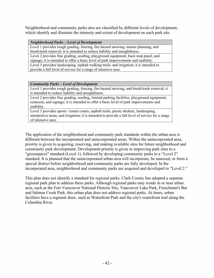
- 42 -
Neighborhood and community parks also are classified by different levels of development, which identify and illustrate the intensity and extent of development on each park site.
Neighborhood Parks – Level of Development Level 1 provides rough grading, fencing, fire hazard mowing, master planning, and brush/trash removal; it is intended to reduce liability and unsightliness. Level 2 provides fine grading, seeding, playground equipment, back stop panel, and signage; it is intended to offer a basic level of park improvements and usability. Level 3 provides landscaping, asphalt walking trails, and irrigation; it is intended to provide a full level of service for a range of intensive uses.
Community Parks – Level of Development Level 1 provides rough grading, fencing, fire hazard mowing, and brush/trash removal; it is intended to reduce liability and unsightliness. Level 2 provides fine grading, seeding, limited parking facilities, playground equipment, restroom, and signage; it is intended to offer a basic level of park improvements and usability. Level 3 provides sports / tennis courts, asphalt trails, picnic shelters, landscaping, interpretive areas, and irrigation; it is intended to provide a full level of service for a range of intensive uses.
The application of the neighborhood and community park standards within the urban area is different between the incorporated and unincorporated areas. Within the unincorporated area, priority is given to acquiring, reserving, and making available sites for future neighborhood and community park development. Development priority is given to improving park sites to a "greenspaces" standard (Level 1), followed by developing community parks to a “Level 2” standard. It is planned that the unincorporated urban area will incorporate, be annexed, or form a special district before neighborhood and community parks are fully developed. In the incorporated area, neighborhood and community parks are acquired and developed to “Level 2.” This plan does not identify a standard for regional parks. Clark County has adopted a separate regional park plan to address these parks. Although regional parks may reside in or near urban area, such as the Fort Vancouver National Historic Site, Vancouver Lake Park, Frenchman's Bar and Salmon Creek Park, this urban plan does not address regional parks. At times, urban facilities have a regional draw, such as Waterfront Park and the city's waterfront trail along the Columbia River.
- 43 -
Neighborhood Parks These parks are intended to serve residential areas within walking distance (1/3 to 1/2 mile radius) of the park site. Access is mostly pedestrian, and park sites should be located so that persons living within the service area will not have to cross a major arterial street to get to the site. Children between the ages of five and 12 constitute the primary user group. However, facilities for teenagers and adults may also be provided. The minimum desirable size for a neighborhood park is three to five acres in order to comfortably accommodate typical facilities and activities. Neighborhood parks will not normally exceed 20 acres. Development typically includes landscaping, irrigation, play fields, pedestrian paths and trails, picnic tables, play equipment and sports courts. Park services at the neighborhood level are provided in several ways. Schools meet an important part of the neighborhood recreational need. Neighborhood parks complement and expand on the services provided by school grounds. In certain areas, neighborhood parks are located adjacent to schools or involve developing and upgrading the school site.
Community Parks These parks serve groups of neighborhoods within a one- to three-mile radius of the park site. Access to community parks may be by car, bicycle or on foot. The minimum desirable size is 20 acres, although smaller sites also may be utilized because of their unique location, constraints on property expansion, or historic significance. Sites will not normally exceed 100 acres. The range of facilities provided will be greater than in neighborhood parks and will generally appeal to more diverse user groups. Development typically includes landscaping, irrigation, picnic shelters and tables, tennis courts, covered activity areas, soccer and baseball fields, bike and pedestrian trails, restrooms and parking lots. Swimming pools and recreation centers may be located on these sites. Park services at the community level are provided in several ways. Junior and senior high schools meet an important part of the community recreational need. Community parks complement and expand on the services provided by school grounds. In certain areas, community parks are located adjacent to schools or involve developing and upgrading the school site.
Urban Open Space Urban open space provides visual and psychological relief from man-made development within the urban area. Public access via trails and walkways to these areas is also important to provide passive recreational opportunities where it is compatible with resource protection and environmental regulations. When open space areas can be connected along stream corridors, they
- 44 -
provide valuable wildlife habitat and other ecological benefits. Urban open space sites may or may not be improved, but can include trails, greenway corridors, community gardens, farmed areas, buffers between land uses of differing intensities, such as residential and commercial or industrial activity, and areas within community or neighborhood parks which are left in their natural state. Selection of urban open space sites is based on a variety of criteria, including linkage to other open spaces, schools or public facilities, the need for open space in an area, existing parks and open space in the area, preserving the site's natural features, and the size and quality of the open space.
Trails & Bikeways The city and county have completed a comprehensive trails and bikeway system plan which identifies hiking and biking trails within the city. The plan defines a trail as any "path, route, way, right-of-way, or corridor posted, signed, or designated as open for (non-motorized) travel or passage by the general public." Five trail types are identified:
• regional multi-use trails which provide the major access networks across the county; • local trails which provide access from neighborhoods to regional multi-use trails; • rustic trails which are smaller in scale than the local trail and are intended to provide
access to natural features and to provide loop trail opportunities; • semi-primitive trails which are intended for rural or forest settings; and • bike lanes and pedestrian walkways which are located on city, county and state road
rights-of-way. Trails may be developed in conjunction with various recreational activities, such as jogging, nature study and historic observation. They may be a separate facility, such as a fitness trail, or an element of a larger facility, such as a greenway trail. Surfaces will vary with location and use. Provisions for parking, consistent signage and interpretive markers may also be included in trail development. There is no numerical standard for trail acquisition and development.
Special Areas and Facilities Special areas, special facilities and recreation facilities are generally developed to serve one or more uses. Special areas are typically large enough to be considered a unique location, such as Officers' Row. Special facilities are typically recreational amenities that reside within a park or special area, such as a tennis court or Marshall House. Recreation facilities are designed as larger activity centers and typically have staff support and active recreation programming, such as Marshall, Bagley and Luepke community centers. Special areas and facilities are grouped by function, including arts, centers, gardens, heritage areas, landscapes, outdoor courts, pools, sports fields, water features, trails and miscellaneous. There is no minimum size; however, the site must be large enough to accommodate the specific use. Support facilities may be included, such as restrooms and parking. While there is no universal numerical standard for special facilities, NRPA provides general guidelines for certain recreational facilities.
- 45 -
Conservation and Greenway Systems Conservation and greenway systems are resource-based open spaces. They are acquired with the intent of little or no development. Conservation areas may act as a buffer for an existing park, industrial or residential area, or may protect a sensitive natural area. Greenways are similar to conservation areas, but are typically long, relatively narrow lands that follow roads, creeks, ridges, ravines and other natural or transportation corridors. Conservation and greenway systems serve various functions, including protection of environmentally sensitive areas and wildlife habitat, wildlife viewing, environmental education and trails. The Clark County Open Space Commission identified four categories of conservation, greenway and open space lands:
• River systems and associated flood plains which provide low-intensity recreation, natural vegetation, shorelines, and wildlife habitat;
• Columbia River lowlands which provide benefits similar to river systems and flood plains but of a much larger scale;
• Cascade foothills which provide significant wildlife habitat, vegetation, sensitive water features and remote/low-intensity recreation; and
• Dispersed open space areas. All but the Cascade foothills category apply to lands within the city and its urban growth area. There is no numerical standard for conservation and greenway systems.
Community Schools & Centers Community schools and centers are public school facilities that are designed and operated jointly between the school district and the city recreation department. Through joint use agreements, school facilities become available for the delivery of recreation programs and services during non-school hours. Community school centers are strategically located within the urban area. When used in combination with a full-service recreation center located in the same area, community school centers provide an effective mechanism for the delivery of recreation services and programs at the community and neighborhood level.
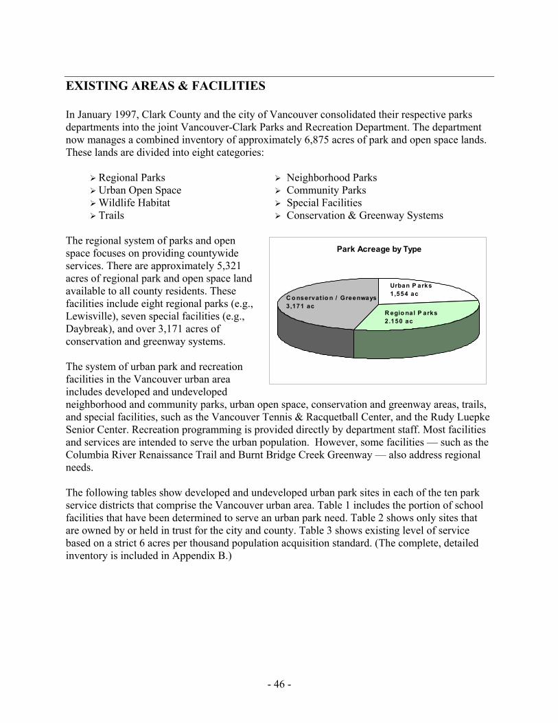
- 46 -
EXISTING AREAS & FACILITIES In January 1997, Clark County and the city of Vancouver consolidated their respective parks departments into the joint Vancouver-Clark Parks and Recreation Department. The department now manages a combined inventory of approximately 6,875 acres of park and open space lands. These lands are divided into eight categories:
Regional Parks Neighborhood Parks Urban Open Space Community Parks Wildlife Habitat Special Facilities Trails Conservation & Greenway Systems
The regional system of parks and open space focuses on providing countywide services. There are approximately 5,321 acres of regional park and open space land available to all county residents. These facilities include eight regional parks (e.g., Lewisville), seven special facilities (e.g., Daybreak), and over 3,171 acres of conservation and greenway systems. The system of urban park and recreation facilities in the Vancouver urban area includes developed and undeveloped neighborhood and community parks, urban open space, conservation and greenway areas, trails, and special facilities, such as the Vancouver Tennis & Racquetball Center, and the Rudy Luepke Senior Center. Recreation programming is provided directly by department staff. Most facilities and services are intended to serve the urban population. However, some facilities — such as the Columbia River Renaissance Trail and Burnt Bridge Creek Greenway — also address regional needs. The following tables show developed and undeveloped urban park sites in each of the ten park service districts that comprise the Vancouver urban area. Table 1 includes the portion of school facilities that have been determined to serve an urban park need. Table 2 shows only sites that are owned by or held in trust for the city and county. Table 3 shows existing level of service based on a strict 6 acres per thousand population acquisition standard. (The complete, detailed inventory is included in Appendix B.)
Park Acreage by Type
C o nservat io n / Greenways3,171 ac
Urban P arks1,554 ac
R egio nal P arks2.150 ac
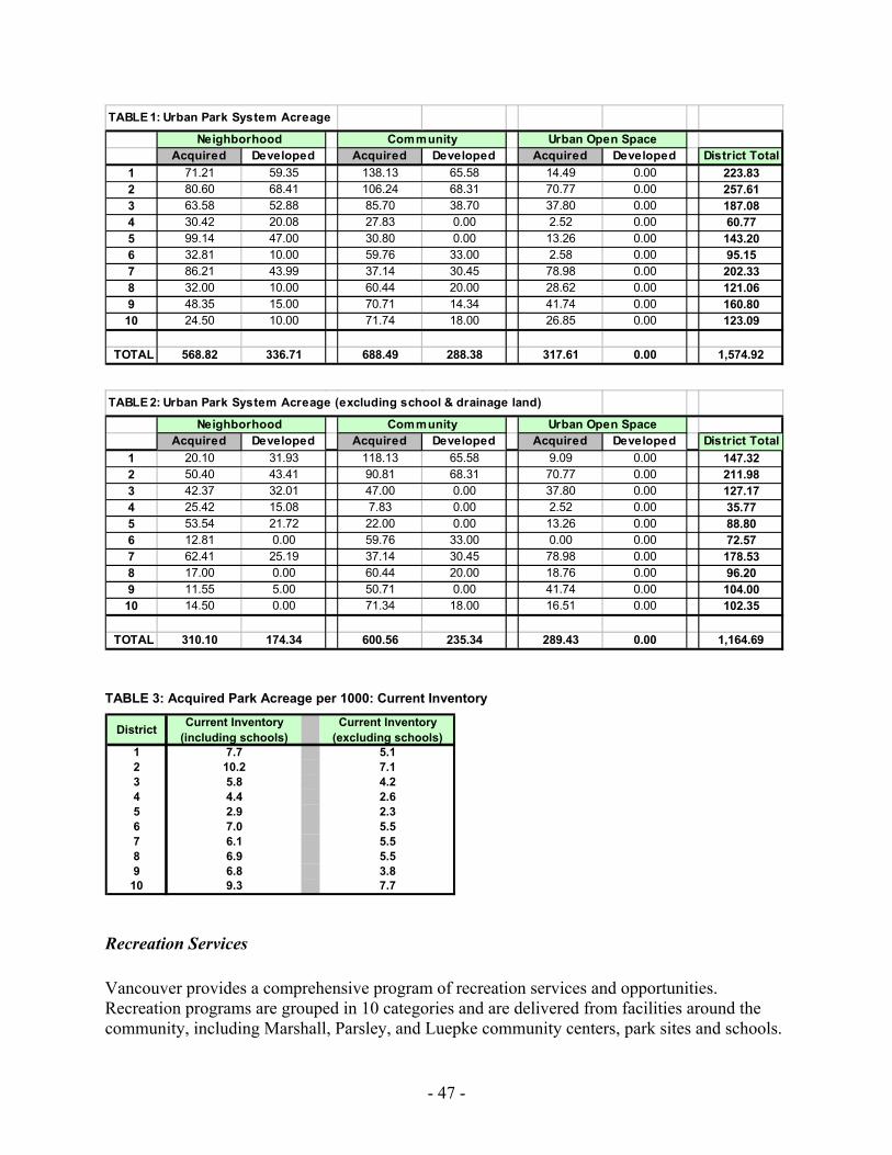
- 47 -
TABLE 3: Acquired Park Acreage per 1000: Current Inventory
Recreation Services Vancouver provides a comprehensive program of recreation services and opportunities. Recreation programs are grouped in 10 categories and are delivered from facilities around the community, including Marshall, Parsley, and Luepke community centers, park sites and schools.
TABLE 2: Urban Park System Acreage (excluding school & drainage land)
Acquired Developed Acquired Developed Acquired Developed District Total1 20.10 31.93 118.13 65.58 9.09 0.00 147.322 50.40 43.41 90.81 68.31 70.77 0.00 211.983 42.37 32.01 47.00 0.00 37.80 0.00 127.174 25.42 15.08 7.83 0.00 2.52 0.00 35.775 53.54 21.72 22.00 0.00 13.26 0.00 88.806 12.81 0.00 59.76 33.00 0.00 0.00 72.577 62.41 25.19 37.14 30.45 78.98 0.00 178.538 17.00 0.00 60.44 20.00 18.76 0.00 96.209 11.55 5.00 50.71 0.00 41.74 0.00 104.0010 14.50 0.00 71.34 18.00 16.51 0.00 102.35
TOTAL 310.10 174.34 600.56 235.34 289.43 0.00 1,164.69
Neighborhood Community Urban Open Space
TABLE 1: Urban Park System Acreage
Acquired Developed Acquired Developed Acquired Developed District Total1 71.21 59.35 138.13 65.58 14.49 0.00 223.832 80.60 68.41 106.24 68.31 70.77 0.00 257.613 63.58 52.88 85.70 38.70 37.80 0.00 187.084 30.42 20.08 27.83 0.00 2.52 0.00 60.775 99.14 47.00 30.80 0.00 13.26 0.00 143.206 32.81 10.00 59.76 33.00 2.58 0.00 95.157 86.21 43.99 37.14 30.45 78.98 0.00 202.338 32.00 10.00 60.44 20.00 28.62 0.00 121.069 48.35 15.00 70.71 14.34 41.74 0.00 160.8010 24.50 10.00 71.74 18.00 26.85 0.00 123.09
TOTAL 568.82 336.71 688.49 288.38 317.61 0.00 1,574.92
Neighborhood Community Urban Open Space
District Current Inventory (including schools)
Current Inventory (excluding schools)
1 7.7 5.12 10.2 7.13 5.8 4.24 4.4 2.65 2.9 2.36 7.0 5.57 6.1 5.58 6.9 5.59 6.8 3.8
10 9.3 7.7
- 48 -
The use of school sites and facilities for the delivery of recreation services has become increasingly important. (An inventory of other available services is included in Appendix C.) Youth Services -- Youth Services offer a variety of programs for youth 12 years of age and under. Infants and preschoolers are offered preschool and enrichment classes. School age children are able to take advantage of Kids First! after school programs, Saturday Open Gym, family nights and youth enrichment classes. During the summer, Summer Playgrounds, the Summer Meal Program through the U.S. Department of Agriculture, Funwagon, Preschool and Youth Daycamps are offered. Special events offered throughout the year include: Spring Break, Earth Day for Kids, Keep Kids Healthy Funday, 4th of July Games and winter break activities. Teen Program -- The Teen Program provides recreational opportunities and events for teens, ages 12 to 19. A teen council, made up of youth from local high schools, meets monthly to share ideas and plan activities that include dances, late night programs, special trips and community projects. Citizens of Disability -- This program serves people with developmental disabilities, ages 13 through adult. Activities include daytime leisure education, cooking, Monday Fundays and self-improvement classes for students transitioning from high school. Evening and weekend activities include cooking and craft classes, FunNights, monthly dances and trips. "It's a Fashionable Life," an annual fund raiser, involves people of all ages and abilities in an evening that includes a fashion show, entertainment and a dance. Adult Enrichment -- The Adult Enrichment Program offers a wide variety of classes, including arts and crafts, self-enhancement, dance, dog training and hobby ideas. Senior Enrichment -- Through the Senior Enrichment Program, residents over 50 years of age are actively involved in diverse recreational and educational opportunities. With emphasis on enhancing dignity, supporting independence and encouraging participation in the community, Senior Programs fulfill the city's commitment to support a healthy and active population of older citizens. The program offers a variety of classes, dances, ongoing activities, special events and leisure services. The Senior Trip program offers day and overnight trips to local places and distant lands. Senior Nutrition and Activities Program -- The Senior Nutrition and Activities Program (SNAP) encompasses two sub-programs providing services throughout Clark County to persons 60 years and over. SNAP provides meals and social interaction at 10 centers with programs designed to keep seniors involved in the community and aware of the importance of nutrition in a healthy lifestyle. Limited transportation is available, and some provision is made for special diets. Meals on Wheels delivers meals to homebound persons using volunteer drivers. Special diets are available for persons on diabetic, low sodium and low cholesterol diets. Fitness -- The Fitness Program, operating from the Parsley Fitness Center, provides a climate-controlled atmosphere complete with aerobic and weight rooms. Ongoing, open enrollment classes are offered each week, including step and dance aerobics, yoga, T'ai Chi and circuit training specialized for pre/post natal, overweight, seniors and beginning participants. The state-
- 49 -
of-the-art weight room provides fitness machines, free weights and cardiovascular machines. Specialty wellness programs offered throughout the year include body composition analysis, complete fitness testing, nutrition counseling, one-on-one consultations and blood chemistry analysis and interpretations. Youth Sports -- The Youth Sports Program is designed to provide opportunities to participate in athletics, recreational sports and outdoor sporting activities in the forms of leagues, classes, camps, clinics, outings and drop-in sports programs. Participants ages four and up are offered a wide range of sports programs designed for safe participation for all athletic abilities. Team and League Sports -- League programs are offered that are enjoyable to participants and suitable to all skill levels. Fun, sportsmanship and competition are promoted. Registration is by teams, and an extra player list for individuals interested in playing is maintained. Volleyball participants are 15 years and older, in women's and coed leagues. Softball is for players 15 years and older, in leagues and tournaments for men, women and coed in both spring/summer and fall seasons. Basketball is separated by age: teen league for high school students not playing on their school team, and adult league for participants over 18 and out of school. The adult program offers leagues throughout the year. Aquatics -- Marshall and Hough pools provide swimming and aquatic programs for citizens ranging from six months of age through adults. Senior exercise is held three times a week. General open swim and family swim times are offered at various times throughout the week. Competitive swimming is offered through the Vancouver Swim Club.
Other Local Facilities
US Forest Service Approximately 1,087 acres of the Gifford Pinchot National Forest are located within Clark County. The majority of the National Forest is located east and north of Clark County and extends from the Columbia River to Mount Rainier. It contains 1,312,000 acres and includes the 110,000 acre Mount St. Helens National Volcanic Monument. Forest Service lands provide a variety of recreational opportunities including camping, hiking, hunting, fishing, horseback riding, and snowmobiling. These acres are not included in the urban parks inventory.
National Park Service The National Park Service operates and maintains the 209-acre Fort Vancouver National Historic Site that is located in Vancouver near the Columbia River. The fort was established by the Hudson’s Bay Company in 1824 and was the earliest white settlement in Clark County. A visitor’s center has been built and portions of the fort have been reconstructed. The National Park Service also maintains parade grounds and a play area. These acres are not included in the urban parks inventory.
US Fish & Wildlife Service The U.S. Fish and Wildlife Service manages the Ridgefield National Wildlife Refuge, located on the Columbia River in northwest Clark County. The refuge covers 5,149 acres and is the largest wildlife preserve in the county. The refuge includes a wide range of habitats, including emergent,
- 50 -
scrub/shrub, and forested wetlands, and riparian and upland forests. Some parts of the refuge are leased for crop production and managed to support wildlife species such as Canada geese, sandhill cranes, tundra swans, and a variety of ducks. While some parts of the refuge are closed to public access, other areas provide a variety of recreation opportunities. These include wildlife observation, hiking, environmental education, fishing, and seasonal waterfowl hunting in designated public hunting areas. A 1.9-mile nature trail extends through the “Carty Unit” at the north end of the refuge. A new 2-mile hiking trail, the Kiwa trail, is ADA accessible. And the 4-mile auto route on the “River S Unit” provides additional bird-watching opportunities. The U.S. Fish and Wildlife Service also manages the 984-acre Steigerwald Lake National Wildlife Refuge located on the Columbia River east of the Port of Camas/Washougal Industrial Park. Most of the refuge was purchased by the U.S. Army Corps of Engineers in 1985 to mitigate damage caused by the construction of the second powerhouse at Bonneville Dam. The land was transferred to the U.S. Fish and Wildlife Service in 1988 for management. Management plans are now being written, and will determine how much of the refuge will be accessible for recreation. At the present time, hikers, horseback and bicycle riders, and dog owners use the top of the dike. These acres are not included in the urban parks inventory.
Washington State Department of Fish and Wildlife The state Department of Fish and Wildlife is mandated by the state Legislature to preserve, protect, and perpetuate wildlife and to provide fishing, hunting, and outdoor recreation opportunities compatible with healthy and diverse wildlife populations. In Clark County, the department manages five wildlife and public hunting areas. These are: Two Forks Wildlife Area (50 acres at the confluence of the East and North Forks Lewis Rivers), Jenny Creek (20 acres located 3/4 mile north of La Center), Pigeon Springs (127 acres located on Cedar Creek west of Amboy), Vancouver Lake (477 acres on La Frambois Road at the south end of Vancouver Lake), and Shillapoo Wildlife Area (1,684 acres between Lower River Road and SR501 west of Vancouver Lake). In addition, the department has developed boat launches and public access areas on many of the county’s lakes and rivers. These include, for example, Daybreak Boat Launch on the East Fork of the Lewis River which was developed through a partnership between Clark County and the state Department of Fish and Wildlife. These acres are not included in the urban parks inventory.
Washington State Department of Natural Resources The Department of Natural Resources is the largest public landowner in Clark County. DNR’s most extensive land holdings cover about 58,497 acres within the 90,000-acre Yacolt Multiple Use Area. The YMUA lies in eastern Clark County and Skamania County. Recreational opportunities include fishing, hiking, hunting, horseback riding, off-road vehicle use, and motorcycle riding. DNR has developed ten camping and/or picnic areas (2 camping sites currently under construction) within the Multiple Use Area, six of which are located in Clark County. These acres are not included in the urban parks inventory. DNR also manages Caterpillar Island and the Woodland Special Campground for the handicapped. Caterpillar Island is located in the Columbia River four miles northwest of downtown Vancouver. Access is by boat only and facilities include four picnic sites. The
- 51 -
Woodland Special Campground is located three miles east of Woodland on County Road 38. Facilities include 10 camp sites, five picnic sites, trails, and playground equipment.
Washington State Department of Parks and Recreation The Washington State Parks and Recreation Department owns and manages four park sites in Clark County: Battle Ground Lake, Paradise Point, Reed Island, and Wormald. Total property holdings in Clark County are 1,044. These acres are not included in the urban parks inventory. Battle Ground Lake State Park encompasses 280 acres with 4,100 feet of freshwater shoreline surrounding 28-acre Battle Ground Lake. Approximately 45 acres of the park have been developed. Facilities include 10 miles of hiking and horse trails, a swimming beach and bathhouse, boat launch, 35 vehicle access overnight camp sites, 15 walk-in camp sites, a group camp with four Adirondacks, one large and two small group shelters, 89 picnic sites, children’s play equipment, and a ballfield. Two rental cabins and water and power hook-ups for recreational vehicles at some campsites will be added soon. Two full-time park rangers live on site. In addition, a volunteer campground host lives at the park year round. Paradise Point State Park encompasses 96 acres and 6,180 feet of freshwater shoreline on the East Fork of the Lewis River immediately east of Interstate 5. Facilities include 70 drive-to camp sites, nine walk-in camp sites, swimming beach, picnic tables, trails, a primitive boat launch, amphitheater, volleyball courts, horseshoe pits, and a play area for children. Paradise Point State Park is located at the downstream end of the Lower Lewis River Greenway System. This system encompasses almost 2,000 acres and includes 10 miles of shoreline on the East Fork Lewis. Land managers include state parks, WDFW, Clark County, and private conservation groups. Reed Island State Park is located 20 miles east of Vancouver in the Columbia River. Reed Island encompasses 508 acres with approximately six miles of freshwater shoreline. Facilities include ten camp sites, several picnic areas, a one-half mile hiking trail, and a vault toilet. Reed Island supports one of the largest rookeries for great blue heron in the Pacific Northwest. Wormald State Park encompasses 160 acres. The park sits near the East Fork of the Lewis River, east of Moulton Falls, and is undeveloped. Wormald is surrounded by private property and access is walk-in only. The State Parks Commission recently approved the transfer of an additional 248 acres near Washougal for a state park. The property is located along Washougal River Road.
Cities and Towns There are eight incorporated cities in Clark County: Vancouver, Camas, Washougal, Ridgefield, Battle Ground, La Center, Yacolt, and part of Woodland, which overlaps Clark and Cowlitz Counties. Each city provides its own park facilities. These facilities are intended to serve city residents; however, they occasionally serve a regional need. For example, both Camas and Washougal have been active in acquiring open space lands in the Washougal River Greenway, and Camas owns portions of and manages the 3.5-mile Lacamas Heritage Trail.
- 52 -
School Districts There are nine public school districts in Clark County that provide, in addition to core educational programs, a variety of recreation opportunities and facilities for area residents. The Vancouver School District and the Evergreen School District compose nearly all the Vancouver UGA. Facilities typically include play courts, soccer fields, baseball fields, football fields, running tracks, open play meadows, and children’s play apparatus. Vancouver School District also provides indoor swimming facilities. Individual school board policies govern the general public use of school-based recreation facilities during non-school hours. Some school districts allow organizations, such as youth soccer and baseball groups, to reserve and rent school buildings, playgrounds, and athletic fields. School sites are currently included in the urban parks inventory on a pro-rated basis of site size.
Private and Nonprofit Private recreation facilities exist throughout Clark County. They provide a wide range of recreation activities, generally on a membership or fee basis. For example, the Cedars Golf Course is open to the public on a fee basis. This facility provides a full-size, 18-hole golf course, driving range, putting greens, and pro shop. The private recreation industry influences recreation planning by providing needed facilities, thereby easing the burden on public recreation facilities. However, when these facilities are not available for general public use, they are not considered in the overall assessment of public demand and need and are not included in the urban parks inventory. Nonprofit organizations provide a variety of recreation facilities in the Vancouver UGA and throughout the county. These facilities are typically dedicated to a single use, such as baseball or soccer, and are reserved for the teams and leagues that developed them. When located on park land, these facilities are available to the public when not in use by the nonprofit organization. The Salmon Creek Sports Complex north of Hazel Dell is an example. An example of a multi-purpose nonprofit facility is the $8.6 million, 45,000 sq. ft. family YMCA that opened in May 2000. This facility provides indoor swimming, sports courts, climbing walls, and exercise, meeting, and activity rooms. In addition, private land trusts are becoming increasingly involved in Vancouver and Clark County with the acquisition, preservation, and stewardship of habitat and open space lands. The Columbia Land Trust, for example, currently owns East Biddle Lake in Vancouver and a portion of Whipple Creek Park that will become a community park serving the urban growth area.
Partnership Facilities Much like private and nonprofit facilities, recreation programs and facilities are sometimes provided through partnerships between the city or county and a private or nonprofit organization. The Clark County Fairgrounds, located west of Interstate 5 near the I-5/179th Street interchange, is an example. Clark County owns the fairgrounds. Through a contract with the county, a committee consisting of representatives from the county and the Clark County Fair Association Board of Directors manages all events at the fairgrounds. Existing facilities include a stage and grandstand, equestrian center, commercial and exposition buildings, community center, animal barns, fair offices, and storage facilities. These facilities are not included in the urban parks inventory.
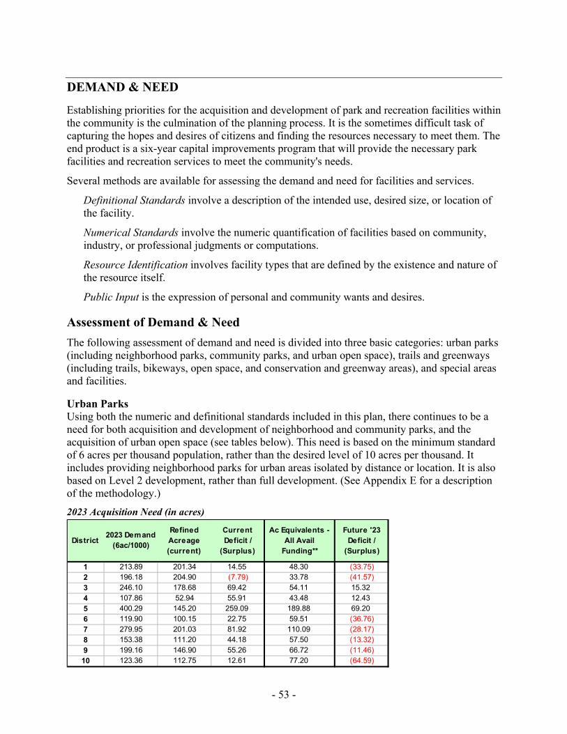
- 53 -
DEMAND & NEED
Establishing priorities for the acquisition and development of park and recreation facilities within the community is the culmination of the planning process. It is the sometimes difficult task of capturing the hopes and desires of citizens and finding the resources necessary to meet them. The end product is a six-year capital improvements program that will provide the necessary park facilities and recreation services to meet the community's needs.
Several methods are available for assessing the demand and need for facilities and services.
Definitional Standards involve a description of the intended use, desired size, or location of the facility.
Numerical Standards involve the numeric quantification of facilities based on community, industry, or professional judgments or computations.
Resource Identification involves facility types that are defined by the existence and nature of the resource itself.
Public Input is the expression of personal and community wants and desires.
Assessment of Demand & Need The following assessment of demand and need is divided into three basic categories: urban parks (including neighborhood parks, community parks, and urban open space), trails and greenways (including trails, bikeways, open space, and conservation and greenway areas), and special areas and facilities.
Urban Parks Using both the numeric and definitional standards included in this plan, there continues to be a need for both acquisition and development of neighborhood and community parks, and the acquisition of urban open space (see tables below). This need is based on the minimum standard of 6 acres per thousand population, rather than the desired level of 10 acres per thousand. It includes providing neighborhood parks for urban areas isolated by distance or location. It is also based on Level 2 development, rather than full development. (See Appendix E for a description of the methodology.)
2023 Acquisition Need (in acres)
District2023 Demand
(6ac/1000)
Refined Acreage (current)
Current Deficit /
(Surplus)
Ac Equivalents - All Avail
Funding**
Future '23 Deficit /
(Surplus)
1 213.89 201.34 14.55 48.30 (33.75)2 196.18 204.90 (7.79) 33.78 (41.57)3 246.10 178.68 69.42 54.11 15.324 107.86 52.94 55.91 43.48 12.435 400.29 145.20 259.09 189.88 69.206 119.90 100.15 22.75 59.51 (36.76)7 279.95 201.03 81.92 110.09 (28.17)8 153.38 111.20 44.18 57.50 (13.32)9 199.16 146.90 55.26 66.72 (11.46)10 123.36 112.75 12.61 77.20 (64.59)
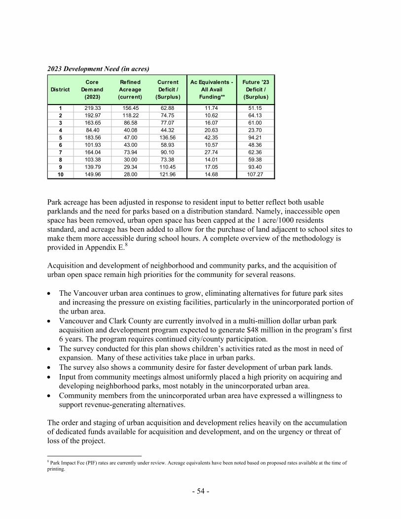
- 54 -
2023 Development Need (in acres)
Park acreage has been adjusted in response to resident input to better reflect both usable parklands and the need for parks based on a distribution standard. Namely, inaccessible open space has been removed, urban open space has been capped at the 1 acre/1000 residents standard, and acreage has been added to allow for the purchase of land adjacent to school sites to make them more accessible during school hours. A complete overview of the methodology is provided in Appendix E.8 Acquisition and development of neighborhood and community parks, and the acquisition of urban open space remain high priorities for the community for several reasons. • The Vancouver urban area continues to grow, eliminating alternatives for future park sites
and increasing the pressure on existing facilities, particularly in the unincorporated portion of the urban area.
• Vancouver and Clark County are currently involved in a multi-million dollar urban park acquisition and development program expected to generate $48 million in the program’s first 6 years. The program requires continued city/county participation.
• The survey conducted for this plan shows children’s activities rated as the most in need of expansion. Many of these activities take place in urban parks.
• The survey also shows a community desire for faster development of urban park lands. • Input from community meetings almost uniformly placed a high priority on acquiring and
developing neighborhood parks, most notably in the unincorporated urban area. • Community members from the unincorporated urban area have expressed a willingness to
support revenue-generating alternatives. The order and staging of urban acquisition and development relies heavily on the accumulation of dedicated funds available for acquisition and development, and on the urgency or threat of loss of the project.
8 Park Impact Fee (PIF) rates are currently under review. Acreage equivalents have been noted based on proposed rates available at the time of printing.
DistrictCore
Demand (2023)
Refined Acreage (current)
Current Deficit /
(Surplus)
Ac Equivalents - All Avail
Funding**
Future '23 Deficit /
(Surplus)
1 219.33 156.45 62.88 11.74 51.152 192.97 118.22 74.75 10.62 64.133 163.65 86.58 77.07 16.07 61.004 84.40 40.08 44.32 20.63 23.705 183.56 47.00 136.56 42.35 94.216 101.93 43.00 58.93 10.57 48.367 164.04 73.94 90.10 27.74 62.368 103.38 30.00 73.38 14.01 59.389 139.79 29.34 110.45 17.05 93.4010 149.96 28.00 121.96 14.68 107.27
- 55 -
Trails & Greenways
Open Space
In its final report issued August 1992, the Clark County Open Space Commission identified three categories of conservation, greenway and open space lands that should be conserved and/or preserved: river systems and associated flood plains which provide low-intensity recreation, natural vegetation, shorelines, and wildlife habitat; Columbia River lowlands which provide benefits similar to river systems and flood plains but of a much larger scale; and Cascade foothills which provide significant wildlife habitat, vegetation, sensitive water features and remote/low-intensity recreation. The commission also identified the economic-based open space categories of agricultural lands and timber lands, and the urban-based category of urban open space which includes high-intensity recreation, trails, shorelines, buffers and landscaping.
Following an inventory of lands in each open space category, analysis of existing and available programs for open space protection, assessment of the need to conserve and/or preserve additional open space, and adoption of planning objectives, the commission developed a three-tier program of open space needs and a two-phase action program. Of these priority projects, all or part of seven are located in Vancouver or the Vancouver urban growth area and have been highlighted in bold text.
Phase I
1a. East Fork Lewis River: Lucia Falls to Moulton Falls Park - 113 acres 1b. East Fork Lewis River: Lewisville Park to Lucia Falls - 248 acres 1c. East Fork Lewis River: Daybreak Park to Lewisville Park - 250 acres 2. Urban Open Space - 25 acres (75 acres total need) 3. Salmon Creek: mouth to Highway 99, including Cougar Creek - 112 acres 4. Lacamas Creek: mouth through Lacamas Lake Park - 25 acres 5. Washougal River: mouth through Sandy River Swimming Hole - 42 acres 6. Burnt Bridge Creek: mouth to Burton Road: 155 acres 7. Vancouver Lake Lowlands: south of Wildlife Refuge - 950 acres
Phase II
1a. East Fork Lewis River: Paradise Point State Park to LaCenter Bottoms - 347 acres 1b. East Fork Lewis River: LaCenter Bottoms to Daybreak - 2,400 acres 2. Lacamas Lake, including Lacamas Crk/Lechtenberg - 110 acres4 3. North Fork Lewis River: Happa to Cedar Creek to Grist Mill - 217 acres 4. Rural Special Forest Area - 50 acres 5a. Salmon Creek: Hwy 99 to Pleasant Valley - 110 acres 5b. Salmon Creek: Pleasant Valley to CASEE site - 250 acres 6. Urban Open Space - 25 acres (75 acres total need) 7. Washougal River: Sandy Swim Hole to mouth of Little Washougal - 170 acres 8. Whipple Creek/Salmon Creek Park Agricultural Area - 160 acres
- 56 -
With the successful acquisition of the 130-acre Dugan property in the Vancouver Lake lowlands in 1994, the city's open space efforts are now focused in two areas. First, the Open Space Commission's priority on urban open spaces is addressed through the categories of neighborhood parks, community parks and urban open space. Demand and need for these land types are evaluated using population-based standards (with most unmet needs located in the unincorporated urban area). Second, Burnt Bridge Creek between Vancouver Lake and Burton Road is given highest priority for conservation and greenway acquisition.
Trails
The Clark County Trails and Bikeway System Plan was completed in December 1992. It is intended to develop a network of trails and bikeways that will interconnect population centers, community facilities, work places, neighborhoods, recreational opportunities and natural greenspaces. Previous city planning efforts considered in developing the Trails and Bikeway System Plan include Discovery Trail (1968, 1984), City Bicycle and Trail Plan (1978), Central Park Master Plan (1979-80), I-5/Burnt Bridge Creek Trail Crossing (1988), and Columbia River Renaissance Trail (1992).
The plan is divided in two types of trails: Right-of-Way Trails/Bikeways and Natural Corridor Trails/Bikeways. Of these projects, all or part of six are located in Vancouver or the Vancouver urban growth area and have been highlighted in bold text. (Beginning and ending points have been adjusted slightly; distances are approximations.)
Right-of-way trails • North Fork Lewis River Trail • Columbia River/Evergreen Highway Trail – Chelsea Road to Camas - 8 miles • Washougal River Corridor Trail • Vancouver's Columbia River Waterfront Trail – Frenchman's Bar to Image Rd. -
11 miles • Lewis & Clark Railroad Right-of-Way Trail – Vancouver to Chelatchie - 30 miles
(considered part of the Chinook Trail plan)
Natural corridor trails • Vancouver Lake Corridor Trail – South Vancouver Lake to Ridgefield - 10 miles • Burnt Bridge Creek/Lacamas Creek Corridor Trail
− Vancouver Lake to Fruit Valley - 2.5 miles − Fruit Valley to I-205 - 9 miles − I-205 to Lacamas Lake Park - 10 miles
• Salmon Creek Corridor Trail – Lake River to 142nd Avenue - 11 miles • North Fork Lewis River Corridor Trail • East Fork Lewis River Corridor Trail
Subsequent discussions were held with community groups and special interest groups. Specific facility and site plans were also reviewed. Five additional trail systems or trail segments within Vancouver or the Vancouver urban growth area were identified.
- 57 -
Additional Trails/Bikeways
Cougar Creek Trail, Hazel Dell Avenue to Salmon Creek Fisher Swale/Lacamas Loop Trail, Lacamas Lake to SR14 Central Park Trail, within Central Park Lieser to David Douglas Connector - 1.5 miles Vancouver Monument to City Center Connector - .5 miles
The greatest need for the acquisition and development of trails within the city are completion of the Burnt Bridge Trail from Nicholson Road to Burton Road, connecting the Burnt Bridge Creek Trail at Fruit Valley to Vancouver Lake Park, completion of the Columbia River Waterfront Trail from Marine Park to Image Road and from I-5 to the Mill Plain Extension, completion of trails within Central Park, and construction of connecting trails between the Columbia River and David Douglas Park and between Vancouver Monument and City Center.
In the recent round of public input, these trail corridor projects were supported by the survey and residents at neighborhood meetings. Priorities include improved connections along the Burnt Bridge Creek trail, Vancouver Lake to the Salmon Creek greenway, and the Columbia River trail.
Recreation Facilities
Sports Fields The Clark County Sports Field Master Plan was published in January 1998. It was developed under the guidance of two community-based committees. A 16-member citizen task force represented user groups. It was composed of representatives of baseball, softball, soccer, and football at the adult, teen, and youth levels. Invitations to participate were sent to 42 leagues. A 13-member administrative task force represented sport field providers. It included members from cities, schools, and Clark County.
The study assessed sports field needs throughout Clark County. All sports fields in Clark County, including those on school sites and within city parks, were inventoried. Information was also collected on the number of teams, their growth rate, amount of play and practice permitted per team per week, and perceptions of sports field needs.
The study's assessment of demand and need for sports fields concluded that there was a significant deficit in sports fields. Additionally, the citizen survey rated outdoor tournament sports complexes as the most important special facilities and programs needed in the community.
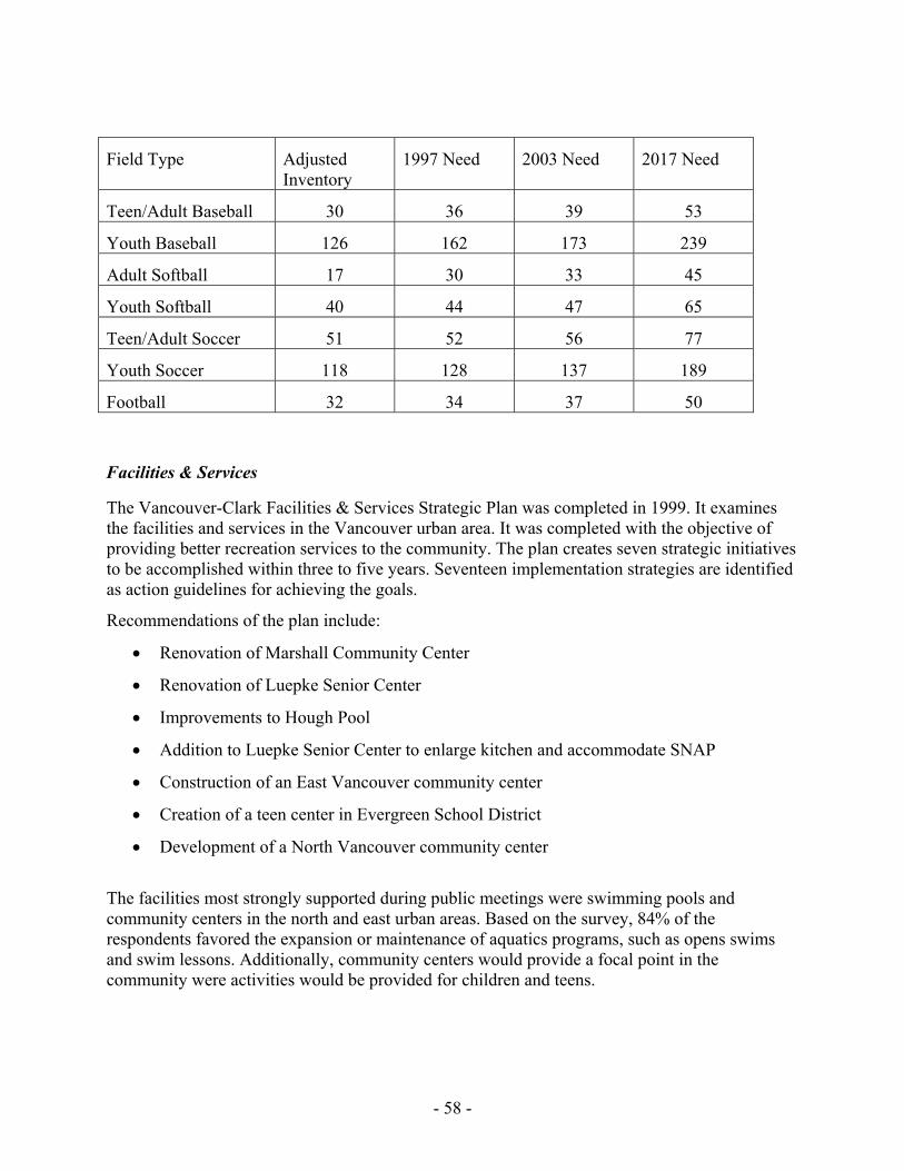
- 58 -
Field Type Adjusted Inventory
1997 Need 2003 Need 2017 Need
Teen/Adult Baseball 30 36 39 53
Youth Baseball 126 162 173 239
Adult Softball 17 30 33 45
Youth Softball 40 44 47 65
Teen/Adult Soccer 51 52 56 77
Youth Soccer 118 128 137 189
Football 32 34 37 50
Facilities & Services
The Vancouver-Clark Facilities & Services Strategic Plan was completed in 1999. It examines the facilities and services in the Vancouver urban area. It was completed with the objective of providing better recreation services to the community. The plan creates seven strategic initiatives to be accomplished within three to five years. Seventeen implementation strategies are identified as action guidelines for achieving the goals.
Recommendations of the plan include:
• Renovation of Marshall Community Center
• Renovation of Luepke Senior Center
• Improvements to Hough Pool
• Addition to Luepke Senior Center to enlarge kitchen and accommodate SNAP
• Construction of an East Vancouver community center
• Creation of a teen center in Evergreen School District
• Development of a North Vancouver community center
The facilities most strongly supported during public meetings were swimming pools and community centers in the north and east urban areas. Based on the survey, 84% of the respondents favored the expansion or maintenance of aquatics programs, such as opens swims and swim lessons. Additionally, community centers would provide a focal point in the community were activities would be provided for children and teens.
- 59 -
FINANCING PROGRAMS
Federal & State Funding Programs
Aquatic Lands Enhancement Account (ALEA) Washington State Department of Natural Resources This program provides matching grants to state and local agencies to protect and enhance salmon habitat and to provide public access and recreation opportunities on aquatic lands. In 1998, DNR refocused the ALEA program to emphasize salmon habitat preservation and enhancement. However, the program is still open to traditional water access proposals. Any project must be located on navigable portions of waterways. ALEA funds are derived from the leasing of state-owned aquatic lands and from the sale of harvest rights for shellfish and other aquatic resources.
IAC Grant Programs Washington State Interagency Committee for Outdoor Recreation The Interagency Committee for Outdoor Recreation (IAC) was created in 1964 as part of the Marine Recreation Land Act (Initiative 215). The IAC grants money to state and local agencies, generally on a matching basis, to acquire, develop, and enhance wildlife habitat and outdoor recreation properties. Some money is also distributed for planning grants. IAC grant programs utilize funds from various sources. Historically, these have included the federal Land and Water Conservation Fund, state bonds, Initiative 215 monies (derived from unreclaimed marine fuel taxes), off-road vehicle funds, Youth Athletic Facilities Account, and the Washington Wildlife and Recreation Program. (A separate summary has been prepared for the WWRP.)
Washington Wildlife and Recreation Program (WWRP) Washington State Interagency Committee for Outdoor Recreation (IAC) The IAC is a state office that allocates funds to local and state agencies for the acquisition and development of wildlife habitat and outdoor recreation properties. Funding sources managed by the IAC include the Washington Wildlife and Recreation Program. The WWRP is divided into Habitat Conservation and Outdoor Recreation Accounts; these are further divided into several project categories. Cities, counties, and other local sponsors may apply for funding in urban wildlife habitat, local parks, trails, and water access categories. Certain state agencies may also apply for funding in natural areas, critical habitat, and state parks categories. Funds for local agencies are awarded on a matching basis. Grant applications are evaluated once each year. However, in 1999, the IAC limited project review in odd-numbered years to local park acquisition. The State Legislature must authorize funding for the WWRP project lists.
Salmon Habitat Recovery Grants Washington State Salmon Recovery Funding Board (SRFB) Lower Columbia Fish Recovery Board (LCRFB) The Washington State Legislature established the Salmon Recovery Funding Board in 1999 to help support salmon recovery in Washington State. The SRFB provides grant funding to local, state, and private individuals and organizations for habitat protection and restoration projects and activities that produce sustainable and measurable benefits to fish. Grants are submitted through local and regional “lead entities,” where those have been established in the state. The Lower
- 60 -
Columbia Fish Recovery Board serves as the lead entity for the lower Columbia region, including Clark County. During the initial grant cycle in 1999/2000, project sponsors were required to provide a minimum 15% local match and monitoring and stewardships programs had be provided for each project.
Wetlands Reserve Program (WRP) Natural Resources Conservation Service (NRCS) The WRP provides landowners the opportunity to preserve, enhance, and restore wetlands and associated uplands. The program is voluntary and provides three enrollment options: permanent easements, 30-year easements, and 10-year restoration cost-share agreements. In all cases, landowners retain the underlying ownership in the property and management responsibility. Land uses may be allowed that are compatible with the program goal of protecting and restoring the wetlands and associated uplands. The NRCS manages the program and may provide technical assistance.
Water Resources Development Act Environmental Restoration Programs and Authorities U.S. Army Corps of Engineers The U.S. Army Corps of Engineers provides funds for environmental and/or ecosystem restoration projects under provisions of the Water Resources Development Act (WRDA), as amended. Section 306 of the WRDA of 1990 specifically authorizes environmental restoration as one of the primary missions of the Corps. Environmental and/or ecosystem restoration projects are intended to “improve the condition of a disturbed ecosystem, including its plant and animal communities, or portions thereof, to some prior ecological condition.” Various authorities and programs are established for these purposes. These include General Investigation Studies and “Continuing Authorities” under Sections 206 (’96), 1135 (’86), and 204 (’92) of the WRDA. Generally, projects require the support of a local sponsoring organization and some level of cost sharing is required. The federal share on Continuing Authorities may range as high as $5 million. For General Investigations there is no per project cost limit.
Conservation Reserve Program (CRP) United States Department of Agriculture – Farm Service Agency The Conservation Reserve Program provides annual rental payments and cost-share assistance to help preserve and enhance sensitive habitat areas on qualifying agricultural lands. The program, established in 1986, is voluntary. Lands enrolled in the CRP must be used for riparian buffers, filter strips, shallow water areas for wildlife, or other uses that provide beneficial habitat values. Landowners enter into agreements that last 10 to 15 years. Unlike the 1998 CREP, the CRP is not limited to stream areas that support salmon runs listed under the federal Endangered Species Act.
- 61 -
Washington Conservation Reserve Enhancement Program (CREP) United States Department of Agriculture – Farm Service Agency Natural Resources Conservation Service (NRCS) Clark County Conservation District This program is a federal/state partnership, authorized in 1998, that involves the retirement of farmland for conservation purposes. Washington CREP focuses on the preservation and restoration of riparian habitat that supports salmon listed under the Endangered Species Act. This voluntary program provides financial incentives to farmers and ranchers to remove lands from agricultural production. Eligible landowners enter into agreements for periods of 10 to 15 years. Landowners receive an annual rental payment and cost-sharing is available for habitat enhancements. The federal Farm Service Agency is the primary administrative agency; the Natural Resource Conservation Service and Clark County Conservation District provide technical assistance.
Trust Lands Transfer Program Washington State Department of Natural Resources This program provides a mechanism to protect DNR-managed properties with significant natural, park, or recreational attributes while infusing money into the public school construction fund. The program has been in effect since 1989. The program identifies “common school trust lands” with significant park, recreation, and natural features, which are difficult to manage as income-producing properties for trust beneficiaries and transfers them to more appropriate ownership. The Legislature appropriates funds to “buy out” these properties from the School Trust Program. Revenues equal to the timber value on subject properties are placed in the Common School Construction Account, while the timber is not harvested. The Legislature also provides for the replacement of the land by appropriating the land value of the property to purchase other real property having better income potential for trust beneficiaries. The properties to be preserved may be transferred to local or state agencies. The selection process involves a detailed evaluation system. Key features include: 1) properties must have a high timber value to land value ratio; 2) properties must be of statewide significance for park, recreation, or natural area uses; and 3) the properties must have significant difficulties (e.g., sensitive wildlife habitat) in managing the property for income to trust beneficiaries.
Jobs for the Environment (JFE) Washington State Department of Natural Resources The JFE program was created by the state Legislature in 1993. The program promotes the long-term, stable employment of dislocated natural resource workers in the performance of watershed restoration activities. The program provides minimum funding commitments for salaries and benefits for displaced workers, and funding is also available for training. Since its inception, the program has completed many in-stream, riparian, and upland restoration projects. Entities eligible to apply for funding include state and local governments, tribes, and nonprofit organizations. Funding proposals will focus on limiting factors and recovery strategies within all or a portion of a Water Resource Inventory Area (WRIA). Specific projects will then be identified, prepared, and approved for implementation over the life of the grant agreement.
- 62 -
Forest Legacy Program Washington State Department of Natural Resources U.S. Forest Service This program provides funds to acquire permanent conservation easements on private forestlands that are at risk of being converted to non-forest uses such as residential or commercial development. Congress established the program in 1990, and DNR is the lead state agency for the program in Washington State. The program is intended to preserve “working forests,” where forestlands are managed for the production of forest products and where traditional forest uses are encouraged. These uses will include both commodity production and non-commodity values such as healthy riparian areas, important scenic, aesthetic, cultural, fish, wildlife and recreation resources, and other ecological values. Historically, the program focus has been on the I-90 Highway Corridor east of Puget Sound within the Mountains-to-Sound Greenway area.
Washington State Ecosystems Conservation Program (WSECP) U.S. Fish and Wildlife Service (USFWS) This WSCEP was established in 1990 and is divided into federal- and state-managed components. The federal program focuses funds on projects that help restore habitat for threatened, endangered and sensitive species and, secondarily, for species of concern. In addition, the program attempts to concentrate funds within a limited number of watersheds to maximize program benefits. The program provides funds to cooperating agencies or organizations. These grants, in turn, can be distributed among project sites. The program requires a 50% cost-share from cooperating agencies, and individual landowners at project sites must enter into maintenance/management agreements that have a 10-year minimum duration.
Washington State Ecosystems Conservation Program (WSECP) – Upland Wildlife Restoration Initiative Washington State Department of Fish and Wildlife (WDFW) The Washington Department of Fish and Wildlife will purchase important upland habitat, or provide technical and/or financial assistance to protect, restore, or enhance such habitat on private property. The program emphasizes certain target species including pheasant, quail, and turkey, but also emphasizes protecting and enhancing habitats that support species diversity. The program covers the entire state, with an emphasis on eastern Washington. Private landowners who volunteer for this program enter into agreements that outline protection and maintenance programs. The program includes both agricultural and forestlands.
Local Transportation Improvement Projects Southwest Washington District Washington State Department of Transportation The Southwest Washington District of the Washington State Department of Transportation undertakes a variety of multi-modal transportation construction and improvement projects. These include non-motorized transportation improvements that target pedestrian, bicycle and other non-motorized methods of transportation. The department started in 1999 a large-scale interchange realignment and widening project along I-5, between Main Street and N.E. 78th Street. The project includes a pedestrian overpass that will facilitate a connection of the Burnt Bridge Creek trail system, which is currently divided by the freeway. In general the cost of the
- 63 -
improvements directly associated with the bicycle/pedestrian element can be utilized as a source of local matching funds for grant application purposes.
Community Development Block Grants U.S. Department of Housing and Urban Development
Clark County and Vancouver receive funds each year from the federal Community Development Block Grant Program. These funds are intended to develop viable urban communities by providing decent housing and a suitable living environment, and by expanding economic opportunities, principally for low and moderate income persons.
Vancouver distributes its annual allocation among community development projects (streets, parks, sidewalks, etc.), housing projects and administration. City policy has placed an increasing emphasis on using CDBG funds for housing-related projects, with an allocation goal of 40%. Both city agencies and qualifying non-profit organizations apply for project funding during an annual review process.
Funds received by Clark County are administered by an Urban County Policy Board whose membership is made up of the mayor or a designated representative from each town and city in the county (not including Vancouver) and one county commissioner. Agencies and jurisdictions submit projects for consideration during an annual review process. Funds are awarded on a competitive basis with a maximum projects request for CDBG funds of $330,000. Policy divides project allocations evenly between infrastructure and social service projects.
Local Funding Options Excess Levy Clark County & Vancouver
Washington law allows cities and counties, along with other specified junior taxing districts, to levy property taxes in excess of limitations imposed by statute when authorized by the voters. Levy approval requires 60 percent majority vote at a general or special election. Excess levies by school districts are the most common use of this authority.
General Obligation Bonds Clark County & Vancouver
For the purposes of funding capital projects, such as land acquisitions or facility construction, cities and counties have the authority to borrow money by selling bonds. Voter-approved general obligation bonds may be sold only after receiving a 60 percent majority vote at a general or special election. If approved, an excess property tax is levied each year for the life of the bond to pay both principal and interest. Vancouver and Clark County have maximum debt limits for voter-approved bonds of two and one-half percent of the value of taxable property in the city and the county, respectively. The city has an additional two and one-half percent for municipal water, sewer and lighting facilities, and an additional two and one-half percent for acquisition and development of open space and park facilities.
- 64 -
Councilmanic Bonds Clark County & Vancouver
Councilmanic bonds may be sold by cities and counties without public vote. The bonds--both principal and interest--are retired with payments from existing county or city revenue or new general tax revenue, such as additional sales tax or real estate excise tax. For both cities and counties, the Legislature has set a maximum debt limit for councilmanic bonds of one and one-half percent of the value of taxable property in the city or county, respectively.
Revenue Bonds Clark County & Vancouver
Revenue bonds are sold with the intent of paying principal and interest from revenue generated by the improvement, such as fees and charges. For example, revenue bonds might be sold to fund a public water system that will generate revenue through utility charges to customers. Other funds may be dedicated to assist with repayment; however, it is desirable to have the improvements generate adequate revenue to pay all bond costs. Limits on the use and amount of revenue bonds are generally market-driven through investor faith in the adequacy of the revenue stream to support bond payments.
Development Impact Fees Clark County & Vancouver
Development impact fees are charges placed on new development as a condition of development approval to help pay for various public facilities the need for which is directly created by that new growth and development. Under the Growth Management Act of 1990 (ESHB 2929), counties, cities, and towns may impose impact fees on residential and commercial "development activity" to help pay for certain public facility improvements, including parks, open space, and recreation facilities. Clark County and Vancouver both charge impact fees on new development to help pay for park and transportation facilities. Several school districts within the county have also adopted development impact fees.
Utility Taxes Vancouver
Cities are authorized to impose taxes on utility services, such as telephone, electric and natural gas. Legislative maximums limit the amount of tax that may be collected. For example, the maximum tax rate for electric and natural gas is six percent. Maximums may be exceeded for a specific purpose and time period with majority voter approval. City operated water and sewer utilities do not share the 6% limit.
Sales Tax Clark County & Vancouver
Washington law authorizes the governing bodies of cities and counties to impose sales and use taxes at a rate set by the statute to help "carry out essential county and municipal purposes." The authority is divided into two parts.
Cities and counties may impose by resolution or ordinance a sales and use tax at a rate of five-tenths of one percent on any "taxable event" within their jurisdictions. Cities and counties may also impose an additional sales tax at a rate "up to" five-tenths of one percent on any taxable
- 65 -
event within the city or county. In this case, the statute provides an electoral process for repealing the tax or altering the rate.
Real Estate Excise Tax Clark County & Vancouver
Washington law authorizes the governing bodies of counties and cities to impose excise taxes on the sale of real property within limits set by the statute. The authority of cities and counties may be divided into four parts.
A city or county may impose a real estate excise tax on the sale of all real property in the city or unincorporated parts of the county, respectively, at a rate not to exceed 1/4 of 1% of the selling price to fund "local capital improvements," including parks, playgrounds, swimming pools, water systems, bridges, sewers, etc. Also, the funds must be used "primarily for financing capital projects specified in a capital facilities plan element of a comprehensive plan . . . " This tax is now in effect in both Vancouver and Clark County.
A city or county may impose a real estate excise tax on the sale of all real property in the city or unincorporated parts of the county, respectively, at a rate not to exceed 1/2 of 1%, in lieu of a five-tenths of one percent sales tax option authorized under state law. These funds are not restricted to capital projects. The statute provides for a repeal mechanism.
A city or county--in counties that are required to prepare comprehensive plans under the new Growth Management Act--are authorized to impose an additional real estate excise tax on all real property sales in the city or unincorporated parts of the county, respectively, at a rate not to exceed 1/4 of 1%. These funds must be used "solely for financing capital projects specified in a capital facilities plan element of a comprehensive plan."
Real Estate Excise Tax - Local Conservation Areas Clark County
Boards of County Commissioners may impose--with voter approval--an excise tax on each sale of real property in the county at rate not to exceed one percent of the selling price for the purpose of acquiring and maintaining conservation areas. The authorizing legislation defines conservation areas as "land and water that has environmental, agricultural, aesthetic, cultural, scientific, historic, scenic, or low-intensity recreational value for existing and future generations..." These areas include "open spaces, wetlands, marshes, aquifer recharge areas, shoreline areas, natural areas, and other lands and waters that are important to preserve flora and fauna."
State-Distributed Motor Vehicle Fund Clark County & Vancouver
State law establishes requirements for planning, construction and preservation of trails and paths during the construction or reconstruction of both limited-access and nonlimited-access highways. It also authorizes cities and counties to expend state-distributed motor vehicle fund revenues for planning, accommodating, establishing and maintaining trails and paths. Qualified trails and paths must be served by highways or their rights-of-way, or must separate motor vehicle traffic from pedestrians, equestrians, or bicyclists to a level that will materially increase motor vehicle safety, and be part of the adopted comprehensive plan of the governmental authority with jurisdiction over trails.
- 66 -
Regular Property Tax - Lid Lift Clark County & Vancouver
Counties and cities are authorized to impose ad valorem taxes upon real and personal property. A county's maximum levy rate for general county purposes is $1.80 per $1,000 of assessed valuation. A city's maximum levy rate for general purposes is $3.375 per $1,000 of assessed valuation unless the city is annexed to either a library or fire district, in which case the city levy may not exceed $3.60 per $1,000 of assessed valuation. Based on the city's Firemen's Pension Fund and the existence of the FV Regional Library, Vancouver currently has a statutory limit of $3.325 per $1,000 of assessed valuation.
Limitations on annual increases in tax collections, coupled with changes in property value, causes levy rates to rise or fall. However, in no case may they rise above statutory limits. Once the rate is established each year under the statutory limit, it may not be raised without the approval of a majority of the voters. Receiving voter approval is known as a lid lift. A lid lift may be permanent, or may be for a specific purpose and time period. Other limits on taxing authority remain in effect, such as the aggregate levy rate limits of $5.90 per $1,000 of assessed value and 1% of true and fair market value.
Conservation Futures Clark County
The Conservation Futures levy is provided for in Chapter 84.34 of the Revised Code of Washington. Boards of County Commissioners may impose by resolution a property tax up to six and one-quarter cents per thousand dollars of assessed value for the purpose of acquiring interest in open space, farm, and timber lands. The Board of Clark County Commissioners adopted the Conservation Futures levy in October 1985. Conservation Futures funds may be used for acquisition purposes only. Funds may be used to acquire mineral rights, and leaseback agreements are permitted. The statute prohibits the use of eminent domain to acquire property. Clark County allows all eligible jurisdictions, including cities, to apply for funding from Conservation Futures.
Incentive Measures Current Use Taxation Clark County
Clark County's current use taxation program applies to lands in both incorporated and unincorporated areas. It provides tax reductions to land holders in return for maintaining their land in an undeveloped condition. The program derives its authority in the 1970 Washington Open Space Taxation Act (RCW 84.34, 458-30 WAC), which establishes procedures for tax deferments for agricultural, timber, and open space lands. Owners of such lands may apply to be taxed according to current use, rather than true market value--a considerable difference in some cases. When the property is removed from the program, the tax savings realized by the land owners for a period dating back up to seven years, plus interest, are collected. Tax savings dating back further than seven years may not be collected. If the removal of classification or change of use occurs in less than ten years or if the owner fails to provide two years advance notification of withdrawal, an additional 20 percent penalty is imposed.
- 67 -
Density Bonuses Clark County & Vancouver
Density bonuses are a planning tool used to encourage a variety of public land use objectives, usually in urban areas. They offer the incentive of being able to develop at densities beyond current regulations in one area, in return for concessions in another. Density bonuses are applied to a single parcel or development. An example is allowing developers of multi-family units to build at higher densities if they provide a certain number of low-income units. For density bonuses to work, market forces must support densities at a higher level than current regulations.
Transfer of Development Rights Clark County & Vancouver
The transfer of development rights (TDR) is an incentive-based planning tool that allows land owners to trade the right to develop property to its fullest extent in one area for the right to develop beyond existing regulations in another area. Local governments may establish the specific areas in which development may be limited or restricted and the areas in which development beyond regulation may be allowed. Usually, but not always, the "sending" and "receiving" property are under common ownership. Some programs allow for different ownership, which, in effect, establishes a market for development rights to be bought and sold.
Regulatory Measures A variety of regulatory measures are available to state and local agencies and jurisdictions. Clark County and Vancouver have exercised their regulatory authority under several programs. Programs available to state and local agencies include: Forest Practices - Conversion of Timber Lands, Washington Department of Natural Resources; Shorelines Management Program, Clark County & Vancouver; State Environmental Policy Act (SEPA), Clark County & Vancouver; and Hydraulic Code, Washington State Department of Fisheries and Department of Wildlife.
Other Methods & Funding Sources Land Trusts
Land trusts are private non-profit organizations that traditionally are not associated with any government agency. Land trusts that have completed projects in Clark County include the Nature Conservancy (TNC), the Trust for Public Land (TPL) and the Columbia Land Trust.
Parks & Recreation Foundation
The Parks and Recreation Foundation of Vancouver and Clark County was established in 1999 to accept donations, gifts, and bequests for the enrichment of our community’s parks, recreation, and cultural services. It was formed to offer a stable source of funding to enable parks to serve at the basic level and beyond. The Foundation is a 501(C)3, non-profit corporation, and all gifts are tax-deductible. It is governed by a board of directors that oversee, invest, and administer the donations made to the Foundation.
- 68 -
Private Grants, Donations & Gifts
Many trusts and private foundations provide funding for park, recreation and open space projects. Grants from these sources are typically allocated through a competitive application process, and vary dramatically in size based on the financial resources and funding criteria of the organization. Philanthropic giving is another source of project funding. Efforts in this area may involve cash gifts and include donations through other mechanisms such as wills or insurance policies. Community fund-raising efforts can also support park, recreation, or open space facilities and projects.
Business Sponsorships/Donations
Business sponsorships for youth, teen, adult and senior programs are available throughout the year. Sponsorships and donations range from $5 to $1,000. In-kind contributions are often received, including food, door prizes and computer equipment.
Fundraising
Fundraising projects are used to support special projects and programs. Recycling drives, golf tournaments and candy sales are three examples of successful fundraising efforts.
Interagency Agreements
State law provides for interagency cooperative efforts between units of government. Joint acquisition, development and use of park, recreation and open space facilities has been successfully used by both Vancouver and Clark County. Shared school/park facilities are the most visible example of this concept.
Public/Private Utility Corridors Bonneville Power Administration; Clark Public Utilities; Vancouver
Utility corridors can be managed to maximize protection or enhancement of open space lands. Utilities maintain corridors for provision of services such as electricity, gas, oil, and rail travel. Historically, some utility companies have cooperated with local governments for development of public programs such as parks within utility corridors.
Local Improvement District Clark County & Vancouver
Local Improvement Districts can be formed by local governments for capital projects. The capital project must directly benefit those properties that are assessed, and there must be a relationship between the benefit received and the assessment paid. Typically, these districts fund improvements to sewer, water or road systems through bonds that are subsequently paid back from special assessments that are levied on district members. LIDs are initiated by petition, or in the case of a citywide project, the city could initiate the project by resolution. A petition signed by property owners representing 60 percent of the affected area is necessary to stop a project. Funding for LIDs is usually spread over 10 years. Specific legislation covers use and operation of various LIDs.
Park and Recreation Districts Independently elected park district commissioners
- 69 -
Park and recreation districts may be formed for the purposes of providing leisure-time activities and recreation facilities. Authorized facilities include parks, playgrounds, public campgrounds, boat ramps, public hunting and fishing areas, bicycle and bridal paths, and "other recreation facilities." Park and recreation districts are explicitly authorized to acquire and hold real and personal property. Formation of a park and recreation district must be initiated by petition and requires voter approval.
Park and Recreation Service Areas Board of County Commissioners
Park and recreation service areas may be formed to finance, acquire, construct, improve, maintain or operate park and recreation facilities. They may be initiated by a resolution adopted by the county legislative authority or by a petition. Voter approval is required. Members of the county legislative authority, acting ex officio and independently, compose the governing body of any park and recreation service area created within their county.
Metropolitan Park District Independently elected park district commissioners
Metropolitan park districts may be formed for the purposes of management, control, improvement, maintenance and acquisition of parks, parkways and boulevards. In addition to acquiring and managing their own lands, metropolitan districts may accept and manage park and recreation lands and equipment turned over by any city within the district or by the county. Formation of a metropolitan park district may be initiated in cities of five thousand population or more by city council or city commission ordinance, or by petition, and requires voter approval. The proposed district must have limits coextensive with the limits of the city, and must exclude cities of the fourth class.
Metropolitan Municipal Corporation Independent board of designated elected officials and appointees
Metropolitan municipal corporations may be formed in any area of the state containing two or more cities of which one is a city of the first class (e.g., Vancouver). They may be authorized to perform one or more of the following functions: water pollution abatement, water supply, public transportation, garbage disposal, parks and parkways, and comprehensive planning. Formation of a metropolitan municipal corporation may be initiated by resolution from the largest city, two or more smaller cities, or the board of county commissioners of the proposed area; or by petition. Voter approval is required.
- 70 -
ACTION PLAN This chapter is the plan’s "action program" for meeting the urban parks, recreation, and open space needs of the community. It is based on the policies and priorities developed during the planning process and represents the first eight years of a 20-year plan. The action plan is comprised of this narrative and the accompanying matrix of capital facility projects (CFP). The action plan, along with the CFP, serves as a roadmap for city and county officials as they make financial and policy decisions. The action plan also serves as a tool for citizens to more clearly see what the plan is proposing -- and is not. The action plan has also been segmented by park district for convenience.
Urban Parks The county and city remain committed to their joint urban parks program, including park impact fees for new acquisition and development, and Real Estate Excise Tax for developing existing park sites. Between 1997 and 2001, this program purchased 60 new park sites and developed 13 neighborhood and community parks. The eight-year CFP in this plan identifies 64 sites for acquisition and 44 for development. The CFP implements the city's policy of developing neighborhood and community parks within the city, and the county's policy of developing only community parks in the unincorporated portions of the Vancouver urban growth area. However, the plan also calls for consideration of alternative methods for funding and delivering urban parks services that may allow uniform development of urban parks throughout the urban growth area.
Neighborhood Parks The CFP identifies 50 sites to be acquired for new or expanded neighborhood parks. Additionally, 33 park sites have been identified for development.
Community Parks The CFP identifies 6 sites to be acquired for new or expanded community parks. Additionally, 11 park sites have been identified for development.
Urban Open Space The CFP identifies 8 sites for acquisition. A detailed list of sites can be found by park district on the following pages.
- 71 -
Trails & Greenways
Trails & Bikeways This plan promotes the acquisition and development of trails as an important component of the urban parks system. The CFP continues to implement the Clark County Trails and Bikeway System Plan, which was completed in December 1992. Trail development, both within parks and along natural features, such as greenways, is supported by survey results and citizen input. Additionally, trails provide recreational opportunities for children, teens, and families, which are also supported by survey results and citizen input. Trail and walkway development and improvements are planned for ten parks (as part of “Level 3” park development); along portions of trails or greenways, including Burnt Bridge Creek, Salmon Creek, Cougar Creek, and the Columbia River; and within existing areas and facilities, such as Central Park and the Vancouver Lake Lowlands.
Evergreen West Park Pacific Park Columbia Waterfront Trail Hiddenview Park Leichner Park Salmon Creek Greenway Harney Heights Felida Park Cougar Creek Greenway St Helens Park Carter Park Vancouver Lake Lowlands Fisher Basin Park Burnt Bridge Creek Lewis & Clark RR Trail Haagen Park Central Park Discovery Greenway Project
Open Space, Conservation & Greenway Systems The majority of open space, conservation, and greenway acquisitions are focused on eligible projects under the Urban Open Space category of the park impact fee program. Acquisition of these urban lands is identified as a high priority in the 1992 Open Space Commission Final Report. They are also supported by survey results and citizen input. The Open Space Commission Final Report also recommends acquisition of large open space and greenway systems of regional scale. The most recent large-scale open space acquisitions within the urban area have been in the Vancouver Lake Lowlands, including purchase of the 130-acre Dugan property in 1994. Four non-PIF open space acquisitions are included in this capital facilities program. They are each associated with an existing trail system: Salmon Creek Greenway, Burnt Bridge Creek Greenway, River Shore Trail, and Columbia Waterfront Trail.
- 72 -
Special Areas & Facilities
Sports Fields The capital projects in this plan implement the policy of giving highest short-time priority to upgrading existing fields. They do not fulfill the goal of municipalities, school districts, and private organizations acquiring, developing, maintaining, and scheduling sports field facilities. Nor do they include ballfield projects that begin to meet the needs identified in the Clark County Sports Field Master Plan, which was published in January 1998. The plan does support the policy that the county, cities, school districts, and local sports organizations in Clark County should join to develop a countywide system of sports fields and sports field complexes to serve the baseball, softball, soccer, and football needs of youth and adults. It also supports the policy that athletic fields in new parks, particularly in larger community parks and regional parks should be promoted. Two sports field projects are identified in this CFP: • Field improvements and David Douglas Park, and • Field improvements at Bagley Park.
Facilities & Services The CFP includes several short- and long-term special facility projects. These projects support implementation of the Vancouver-Clark Facilities & Services Strategic Plan, which was completed in 1999, and the Vancouver-Clark 2000 Recreation Program and Cost Recovery Plan. Projects fall into two basic groups: renovation of existing facilities and new construction. There are 33 renovation projects and 4 new construction projects. Projects receiving the most public comment and support are Marshall/Luepke Center improvements, construction of an East Vancouver Recreation Center and Civic Campus, and construction of a Hazel Dell/Salmon Creek Community and Aquatics Center.
- 73 -
Action Plan: Park District #1 (2001-2008) Acquisition: Refer to ‘star’ symbols on map for approximate locations Development: Project Code
Improvements Grading & Seeding
Level 2 Level 3 Other
Esther Short Park ■ Evergreen West Park ■ Carter Park ■ ■ Marshall COM Park ■ ■ Hiddenview Park ■ Central Park ■ Leverich Park ■ Columbia River Trail ■ Washington Park ■ Trails: Central Park Trail Phase I Phase II Discovery Trail Historic Loop Burnt Bridge Creek Greenway Fruit Valley to I-5 Columbia Waterfront Trail Quay to RR bridge Marine Park to Columbia Shores Vancouver Lake Vancouver Lake lowlands – west Fruit Valley Rd to Lower River Rd Special Areas & Facilities: Hough Pool improvements Marshall & Luepke Centers Marshall office remodel Community center security system SNAP Kitchen & office remodel Campus improvements
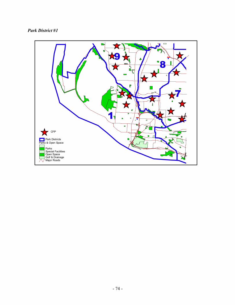
- 74 -
Park District #1
ÊÚÊÚÊÚ
ÊÚ
ÊÚÊÚ
ÊÚÊÚ ÊÚÊÚ
ÊÚÊÚ ÊÚÊÚ
ÊÚÊÚ
ÊÚ
1
7
98
.-,5
(/1
(/50
.-,20599th
Major Roads
Parks & Open Space
ParksSpecial FacilitiesOpen SpaceGolf & Drainage
Park DistrictsÊÚ CFP
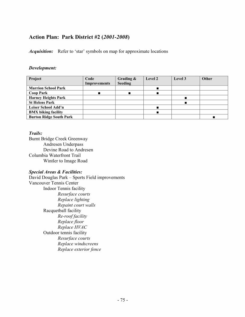
- 75 -
Action Plan: Park District #2 (2001-2008) Acquisition: Refer to ‘star’ symbols on map for approximate locations Development: Project Code
Improvements Grading & Seeding
Level 2 Level 3 Other
Marrion School Park ■ Coop Park ■ ■ ■ Harney Heights Park ■ St Helens Park ■ Leiser School Add’n ■ BMX biking facility ■ Burton Ridge South Park ■ Trails: Burnt Bridge Creek Greenway Andresen Underpass Devine Road to Andresen Columbia Waterfront Trail Wintler to Image Road Special Areas & Facilities: David Douglas Park – Sports Field improvements Vancouver Tennis Center Indoor Tennis facility Resurface courts Replace lighting Repaint court walls Racquetball facility Re-roof facility Replace floor Replace HVAC Outdoor tennis facility Resurface courts Replace windscreens Replace exterior fence
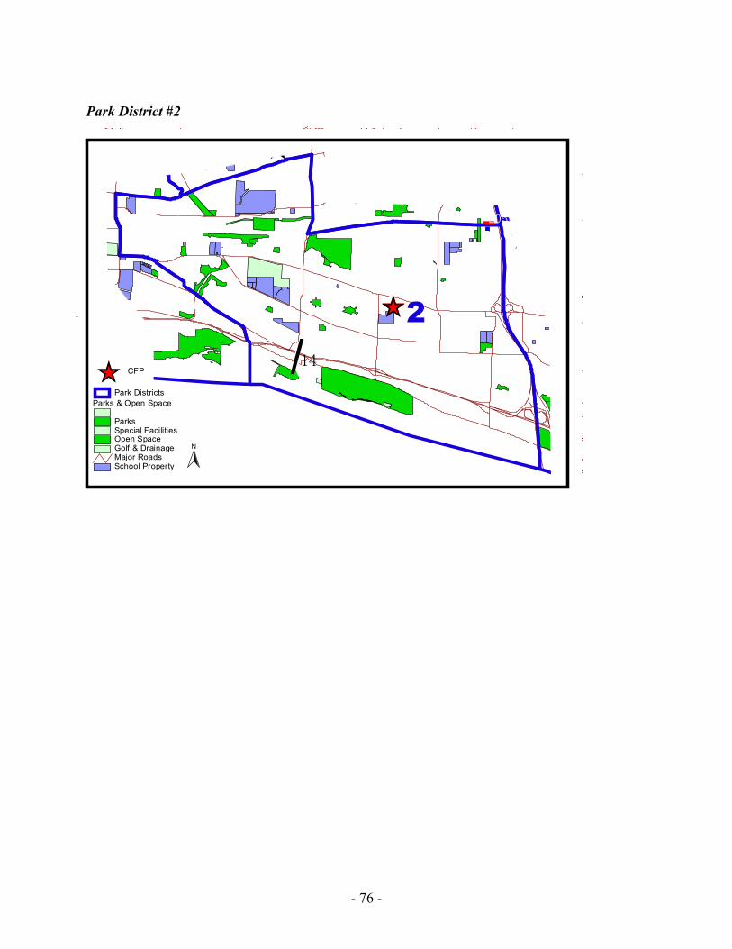
- 76 -
Park District #2
ÊÚ
ÊÚ
ÊÚ
ÊÚÊÚ
2
.-,205
(/14
(/500
School PropertyMajor Roads
Parks & Open Space
ParksSpecial FacilitiesOpen SpaceGolf & Drainage
Park DistrictsÊÚ CFP
N
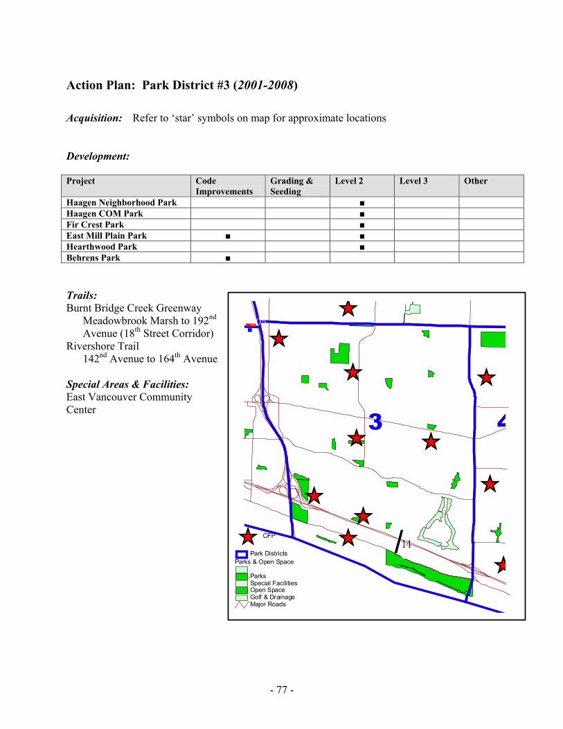
- 77 -
Action Plan: Park District #3 (2001-2008) Acquisition: Refer to ‘star’ symbols on map for approximate locations Development: Project Code
Improvements Grading & Seeding
Level 2 Level 3 Other
Haagen Neighborhood Park ■ Haagen COM Park ■ Fir Crest Park ■ East Mill Plain Park ■ ■ Hearthwood Park ■ Behrens Park ■ Trails: Burnt Bridge Creek Greenway
Meadowbrook Marsh to 192nd Avenue (18th Street Corridor)
Rivershore Trail 142nd Avenue to 164th Avenue
Special Areas & Facilities: East Vancouver Community Center
Major Roads
Parks & Open Space
ParksSpecial FacilitiesOpen SpaceGolf & Drainage
Park DistrictsÊÚ CFP
ÊÚÊÚ
ÊÚ ÊÚ
ÊÚÊÚ
ÊÚ
ÊÚ
ÊÚ
ÊÚ
ÊÚ
3 4
.-,205
(/14
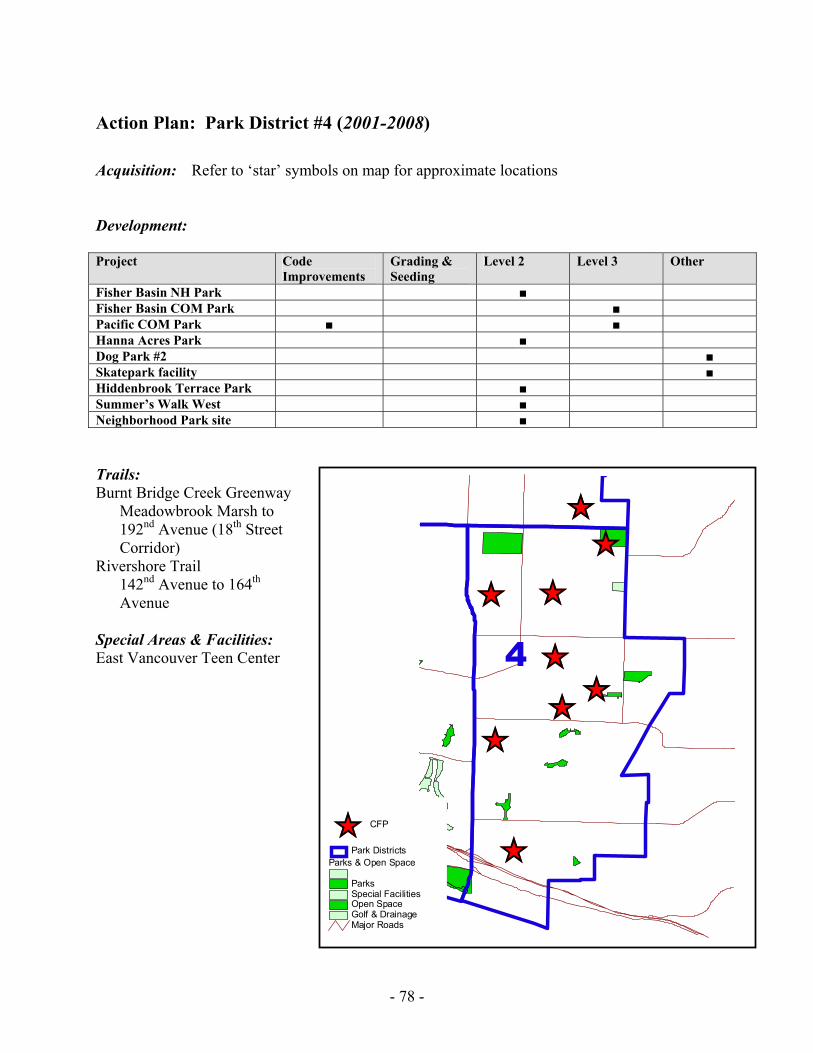
- 78 -
Action Plan: Park District #4 (2001-2008) Acquisition: Refer to ‘star’ symbols on map for approximate locations Development: Project Code
Improvements Grading & Seeding
Level 2 Level 3 Other
Fisher Basin NH Park ■ Fisher Basin COM Park ■ Pacific COM Park ■ ■ Hanna Acres Park ■ Dog Park #2 ■ Skatepark facility ■ Hiddenbrook Terrace Park ■ Summer’s Walk West ■ Neighborhood Park site ■ Trails: Burnt Bridge Creek Greenway
Meadowbrook Marsh to 192nd Avenue (18th Street Corridor)
Rivershore Trail 142nd Avenue to 164th Avenue
Special Areas & Facilities: East Vancouver Teen Center
ÊÚÊÚÊÚ
ÊÚÊÚÊÚ
ÊÚ
ÊÚ
ÊÚ
4
Major Roads
Parks & Open Space
ParksSpecial FacilitiesOpen SpaceGolf & Drainage
Park DistrictsÊÚ CFP
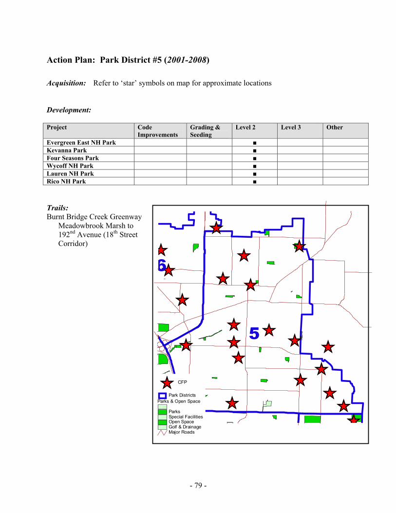
- 79 -
Action Plan: Park District #5 (2001-2008) Acquisition: Refer to ‘star’ symbols on map for approximate locations Development: Project Code
Improvements Grading & Seeding
Level 2 Level 3 Other
Evergreen East NH Park ■ Kevanna Park ■ Four Seasons Park ■ Wycoff NH Park ■ Lauren NH Park ■ Rico NH Park ■ Trails: Burnt Bridge Creek Greenway
Meadowbrook Marsh to 192nd Avenue (18th Street Corridor)
ÊÚ ÊÚ
ÊÚÊÚ
ÊÚ
ÊÚÊÚÊÚ
ÊÚÊÚ
ÊÚÊÚÊÚ
ÊÚÊÚÊÚ
ÊÚ
ÊÚÊÚ
ÊÚ
ÊÚ ÊÚ
5
6
.-,205
162n
d
Major Roads
Parks & Open Space
ParksSpecial FacilitiesOpen SpaceGolf & Drainage
Park DistrictsÊÚ CFP
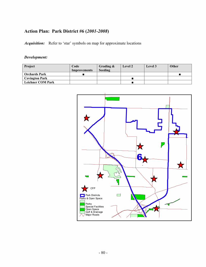
- 80 -
Action Plan: Park District #6 (2001-2008) Acquisition: Refer to ‘star’ symbols on map for approximate locations Development: Project Code
Improvements Grading & Seeding
Level 2 Level 3 Other
Orchards Park ■ ■ Covington Park ■ Leichner COM Park ■
ÊÚ
ÊÚ
ÊÚ
ÊÚ
ÊÚ
ÊÚÊÚ
ÊÚ
ÊÚ
ÊÚ
7
6
Major Roads
Parks & Open Space
ParksSpecial FacilitiesOpen SpaceGolf & Drainage
Park DistrictsÊÚ CFP
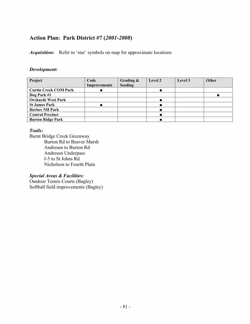
- 81 -
Action Plan: Park District #7 (2001-2008) Acquisition: Refer to ‘star’ symbols on map for approximate locations Development: Project Code
Improvements Grading & Seeding
Level 2 Level 3 Other
Curtin Creek COM Park ■ ■ Dog Park #1 ■ Orchards West Park ■ St James Park ■ ■ Herber NH Park ■ Central Precinct ■ Burton Ridge Park ■ Trails: Burnt Bridge Creek Greenway Burton Rd to Beaver Marsh Andresen to Burton Rd Andresen Underpass I-5 to St Johns Rd Nicholson to Fourth Plain Special Areas & Facilities: Outdoor Tennis Courts (Bagley) Softball field improvements (Bagley)
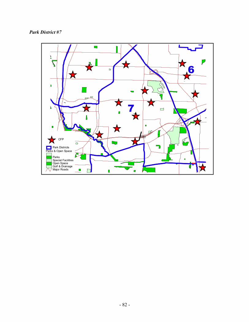
- 82 -
Park District #7
ÊÚ
ÊÚÊÚ
ÊÚ
ÊÚÊÚ
ÊÚÊÚ
ÊÚÊÚ
ÊÚÊÚ
ÊÚÊÚ
ÊÚ
ÊÚ7
6
.-,5
.-,205
(/500
Major Roads
Parks & Open Space
ParksSpecial FacilitiesOpen SpaceGolf & Drainage
Park DistrictsÊÚ CFP
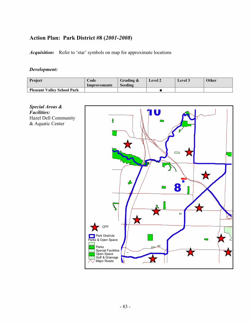
- 83 -
Action Plan: Park District #8 (2001-2008) Acquisition: Refer to ‘star’ symbols on map for approximate locations Development: Project Code
Improvements Grading & Seeding
Level 2 Level 3 Other
Pleasant Valley School Park ■ Special Areas & Facilities: Hazel Dell Community & Aquatic Center
ÊÚ
ÊÚ
ÊÚÊÚ
ÊÚ
ÊÚÊÚ
ÊÚÊÚ
ÊÚ
8
10.-,
.-,205
Major Roads
Parks & Open Space
ParksSpecial FacilitiesOpen SpaceGolf & Drainage
Park DistrictsÊÚ CFP
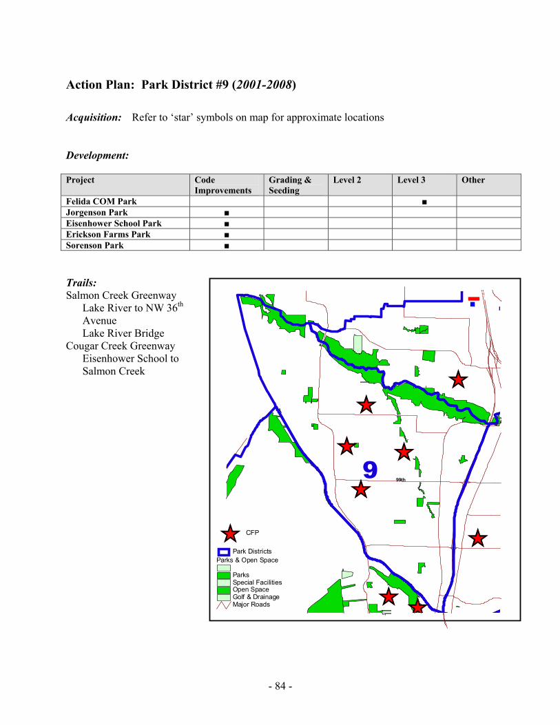
- 84 -
Action Plan: Park District #9 (2001-2008) Acquisition: Refer to ‘star’ symbols on map for approximate locations Development: Project Code
Improvements Grading & Seeding
Level 2 Level 3 Other
Felida COM Park ■ Jorgenson Park ■ Eisenhower School Park ■ Erickson Farms Park ■ Sorenson Park ■ Trails: Salmon Creek Greenway
Lake River to NW 36th Avenue Lake River Bridge
Cougar Creek Greenway Eisenhower School to Salmon Creek
ÊÚÊÚ
ÊÚ
ÊÚ
ÊÚ ÊÚ
ÊÚ
ÊÚ
9
1.-,5
99th
Major Roads
Parks & Open Space
ParksSpecial FacilitiesOpen SpaceGolf & Drainage
Park DistrictsÊÚ CFP
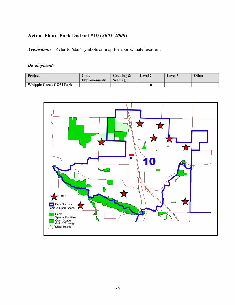
- 85 -
Action Plan: Park District #10 (2001-2008) Acquisition: Refer to ‘star’ symbols on map for approximate locations Development: Project Code
Improvements Grading & Seeding
Level 2 Level 3 Other
Whipple Creek COM Park ■
ÊÚÊÚÊÚ
ÊÚ
ÊÚ ÊÚÊÚ ÊÚ
ÊÚ10.-,5
-,Major Roads
Parks & Open Space
ParksSpecial FacilitiesOpen SpaceGolf & Drainage
Park DistrictsÊÚ CFP
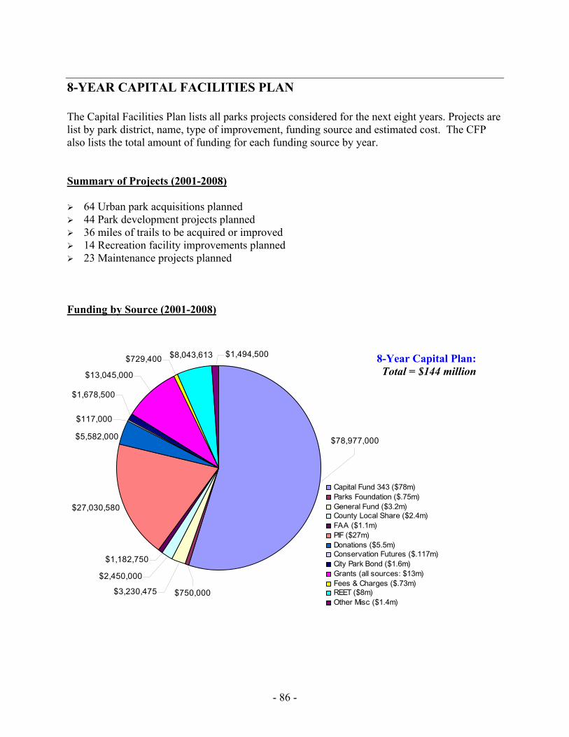
- 86 -
8-YEAR CAPITAL FACILITIES PLAN
The Capital Facilities Plan lists all parks projects considered for the next eight years. Projects are list by park district, name, type of improvement, funding source and estimated cost. The CFP also lists the total amount of funding for each funding source by year. Summary of Projects (2001-2008)
64 Urban park acquisitions planned 44 Park development projects planned 36 miles of trails to be acquired or improved 14 Recreation facility improvements planned 23 Maintenance projects planned
Funding by Source (2001-2008)
$27,030,580
$78,977,000
$729,400
$3,230,475 $750,000
$8,043,613 $1,494,500
$13,045,000
$1,678,500
$117,000
$5,582,000
$1,182,750
$2,450,000
Capital Fund 343 ($78m)Parks Foundation ($.75m)General Fund ($3.2m)County Local Share ($2.4m)FAA ($1.1m)PIF ($27m)Donations ($5.5m)Conservation Futures ($.117m)City Park Bond ($1.6m)Grants (all sources: $13m)Fees & Charges ($.73m)REET ($8m)Other Misc ($1.4m)
8-Year Capital Plan: Total = $144 million
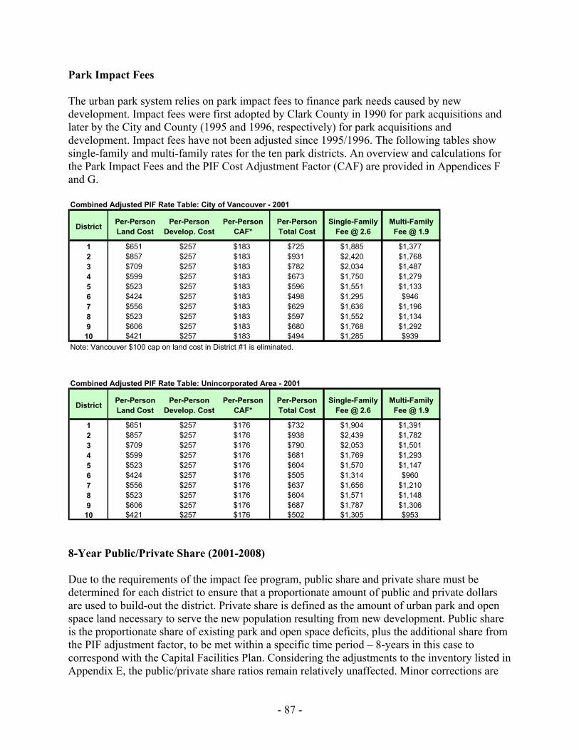
- 87 -
Park Impact Fees The urban park system relies on park impact fees to finance park needs caused by new development. Impact fees were first adopted by Clark County in 1990 for park acquisitions and later by the City and County (1995 and 1996, respectively) for park acquisitions and development. Impact fees have not been adjusted since 1995/1996. The following tables show single-family and multi-family rates for the ten park districts. An overview and calculations for the Park Impact Fees and the PIF Cost Adjustment Factor (CAF) are provided in Appendices F and G.
8-Year Public/Private Share (2001-2008) Due to the requirements of the impact fee program, public share and private share must be determined for each district to ensure that a proportionate amount of public and private dollars are used to build-out the district. Private share is defined as the amount of urban park and open space land necessary to serve the new population resulting from new development. Public share is the proportionate share of existing park and open space deficits, plus the additional share from the PIF adjustment factor, to be met within a specific time period – 8-years in this case to correspond with the Capital Facilities Plan. Considering the adjustments to the inventory listed in Appendix E, the public/private share ratios remain relatively unaffected. Minor corrections are
Combined Adjusted PIF Rate Table: City of Vancouver - 2001
District Per-Person Land Cost
Per-Person Develop. Cost
Per-Person CAF*
Per-Person Total Cost
Single-Family Fee @ 2.6
Multi-Family Fee @ 1.9
1 $651 $257 $183 $725 $1,885 $1,3772 $857 $257 $183 $931 $2,420 $1,7683 $709 $257 $183 $782 $2,034 $1,4874 $599 $257 $183 $673 $1,750 $1,2795 $523 $257 $183 $596 $1,551 $1,1336 $424 $257 $183 $498 $1,295 $9467 $556 $257 $183 $629 $1,636 $1,1968 $523 $257 $183 $597 $1,552 $1,1349 $606 $257 $183 $680 $1,768 $1,292
10 $421 $257 $183 $494 $1,285 $939Note: Vancouver $100 cap on land cost in District #1 is eliminated.
Combined Adjusted PIF Rate Table: Unincorporated Area - 2001
District Per-Person Land Cost
Per-Person Develop. Cost
Per-Person CAF*
Per-Person Total Cost
Single-Family Fee @ 2.6
Multi-Family Fee @ 1.9
1 $651 $257 $176 $732 $1,904 $1,3912 $857 $257 $176 $938 $2,439 $1,7823 $709 $257 $176 $790 $2,053 $1,5014 $599 $257 $176 $681 $1,769 $1,2935 $523 $257 $176 $604 $1,570 $1,1476 $424 $257 $176 $505 $1,314 $9607 $556 $257 $176 $637 $1,656 $1,2108 $523 $257 $176 $604 $1,571 $1,1489 $606 $257 $176 $687 $1,787 $1,306
10 $421 $257 $176 $502 $1,305 $953
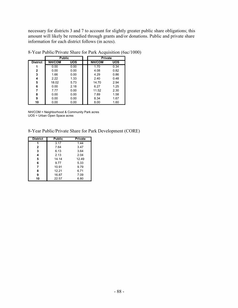
- 88 -
necessary for districts 3 and 7 to account for slightly greater public share obligations; this amount will likely be remedied through grants and/or donations. Public and private share information for each district follows (in acres). 8-Year Public/Private Share for Park Acquisition (6ac/1000)
NH/COM = Neighborhood & Community Park acres UOS = Urban Open Space acres 8-Year Public/Private Share for Park Development (CORE)
District NH/COM UOS NH/COM UOS1 0.00 0.00 1.70 0.342 0.00 0.00 4.08 0.823 1.66 0.00 4.29 0.864 2.22 1.33 2.40 0.485 18.02 5.73 14.70 2.946 0.00 2.18 6.27 1.257 7.77 0.00 11.52 2.308 0.00 0.00 7.89 1.589 0.00 0.00 8.34 1.6710 0.00 0.00 8.00 1.60
Public Private
District Public Private1 3.17 1.442 7.64 3.473 6.13 3.644 2.13 2.045 14.14 12.496 9.77 5.337 10.91 9.798 12.21 6.719 16.87 7.0910 22.57 6.80
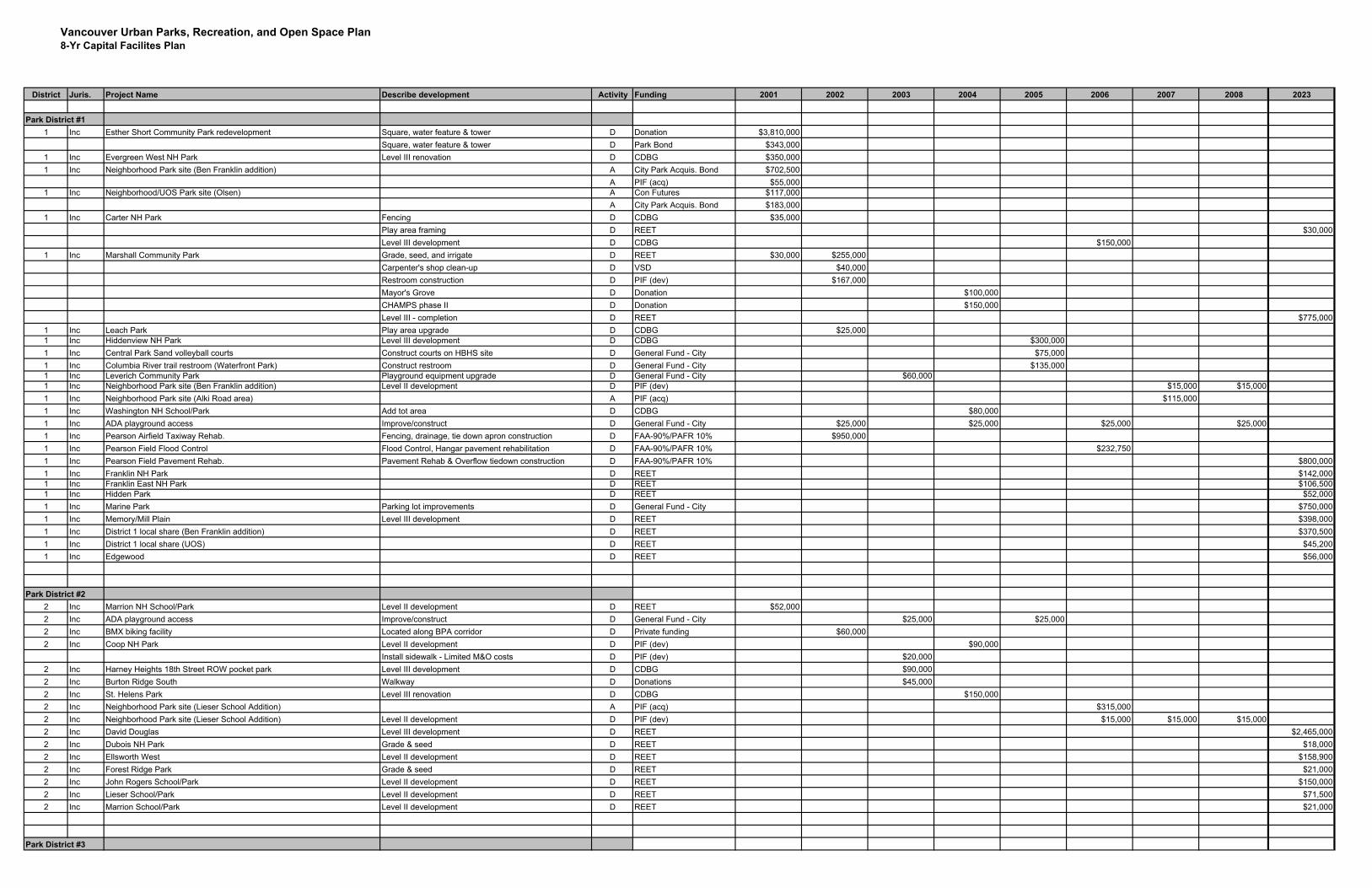
Vancouver Urban Parks, Recreation, and Open Space Plan8-Yr Capital Facilites Plan
District Juris. Project Name Describe development Activity Funding 2001 2002 2003 2004 2005 2006 2007 2008 2023
Park District #11 Inc Esther Short Community Park redevelopment Square, water feature & tower D Donation $3,810,000
Square, water feature & tower D Park Bond $343,0001 Inc Evergreen West NH Park Level III renovation D CDBG $350,0001 Inc Neighborhood Park site (Ben Franklin addition) A City Park Acquis. Bond $702,500
A PIF (acq) $55,0001 Inc Neighborhood/UOS Park site (Olsen) A Con Futures $117,000
A City Park Acquis. Bond $183,0001 Inc Carter NH Park Fencing D CDBG $35,000
Play area framing D REET $30,000Level III development D CDBG $150,000
1 Inc Marshall Community Park Grade, seed, and irrigate D REET $30,000 $255,000Carpenter's shop clean-up D VSD $40,000Restroom construction D PIF (dev) $167,000Mayor's Grove D Donation $100,000CHAMPS phase II D Donation $150,000Level III - completion D REET $775,000
1 Inc Leach Park Play area upgrade D CDBG $25,0001 Inc Hiddenview NH Park Level III development D CDBG $300,0001 Inc Central Park Sand volleyball courts Construct courts on HBHS site D General Fund - City $75,0001 Inc Columbia River trail restroom (Waterfront Park) Construct restroom D General Fund - City $135,0001 Inc Leverich Community Park Playground equipment upgrade D General Fund - City $60,0001 Inc Neighborhood Park site (Ben Franklin addition) Level II development D PIF (dev) $15,000 $15,0001 Inc Neighborhood Park site (Alki Road area) A PIF (acq) $115,0001 Inc Washington NH School/Park Add tot area D CDBG $80,0001 Inc ADA playground access Improve/construct D General Fund - City $25,000 $25,000 $25,000 $25,0001 Inc Pearson Airfield Taxiway Rehab. Fencing, drainage, tie down apron construction D FAA-90%/PAFR 10% $950,0001 Inc Pearson Field Flood Control Flood Control, Hangar pavement rehabilitation D FAA-90%/PAFR 10% $232,7501 Inc Pearson Field Pavement Rehab. Pavement Rehab & Overflow tiedown construction D FAA-90%/PAFR 10% $800,0001 Inc Franklin NH Park D REET $142,0001 Inc Franklin East NH Park D REET $106,5001 Inc Hidden Park D REET $52,0001 Inc Marine Park Parking lot improvements D General Fund - City $750,0001 Inc Memory/Mill Plain Level III development D REET $398,0001 Inc District 1 local share (Ben Franklin addition) D REET $370,5001 Inc District 1 local share (UOS) D REET $45,2001 Inc Edgewood D REET $56,000
Park District #22 Inc Marrion NH School/Park Level II development D REET $52,0002 Inc ADA playground access Improve/construct D General Fund - City $25,000 $25,0002 Inc BMX biking facility Located along BPA corridor D Private funding $60,0002 Inc Coop NH Park Level II development D PIF (dev) $90,000
Install sidewalk - Limited M&O costs D PIF (dev) $20,0002 Inc Harney Heights 18th Street ROW pocket park Level III development D CDBG $90,0002 Inc Burton Ridge South Walkway D Donations $45,0002 Inc St. Helens Park Level III renovation D CDBG $150,0002 Inc Neighborhood Park site (Lieser School Addition) A PIF (acq) $315,0002 Inc Neighborhood Park site (Lieser School Addition) Level II development D PIF (dev) $15,000 $15,000 $15,0002 Inc David Douglas Level III development D REET $2,465,0002 Inc Dubois NH Park Grade & seed D REET $18,0002 Inc Ellsworth West Level II development D REET $158,9002 Inc Forest Ridge Park Grade & seed D REET $21,0002 Inc John Rogers School/Park Level II development D REET $150,0002 Inc Lieser School/Park Level II development D REET $71,5002 Inc Marrion School/Park Level II development D REET $21,000
Park District #3
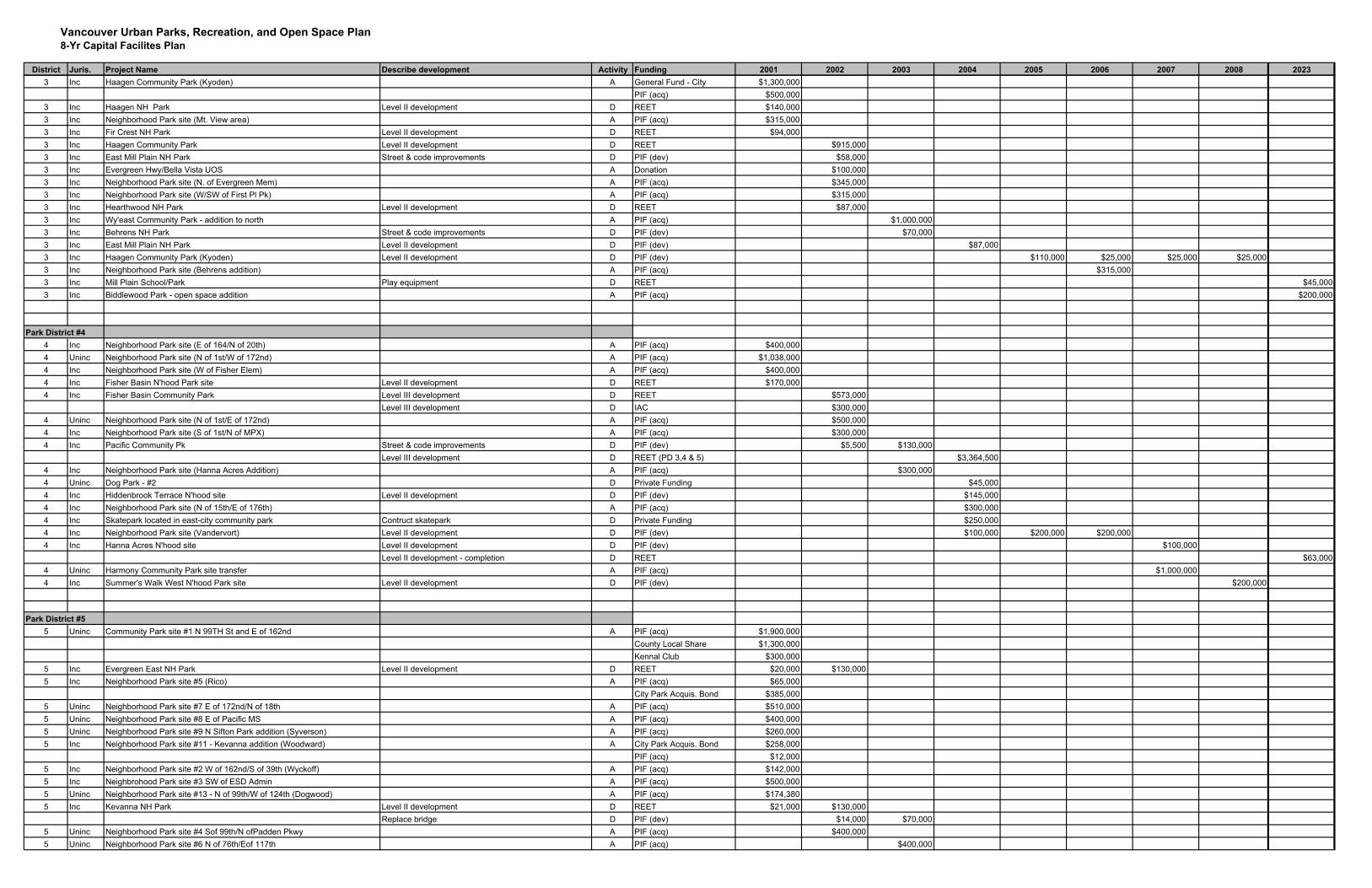
Vancouver Urban Parks, Recreation, and Open Space Plan8-Yr Capital Facilites Plan
District Juris. Project Name Describe development Activity Funding 2001 2002 2003 2004 2005 2006 2007 2008 20233 Inc Haagen Community Park (Kyoden) A General Fund - City $1,300,000
PIF (acq) $500,0003 Inc Haagen NH Park Level II development D REET $140,0003 Inc Neighborhood Park site (Mt. View area) A PIF (acq) $315,0003 Inc Fir Crest NH Park Level II development D REET $94,0003 Inc Haagen Community Park Level II development D REET $915,0003 Inc East Mill Plain NH Park Street & code improvements D PIF (dev) $58,0003 Inc Evergreen Hwy/Bella Vista UOS A Donation $100,0003 Inc Neighborhood Park site (N. of Evergreen Mem) A PIF (acq) $345,0003 Inc Neighborhood Park site (W/SW of First Pl Pk) A PIF (acq) $315,0003 Inc Hearthwood NH Park Level II development D REET $87,0003 Inc Wy'east Community Park - addition to north A PIF (acq) $1,000,0003 Inc Behrens NH Park Street & code improvements D PIF (dev) $70,0003 Inc East Mill Plain NH Park Level II development D PIF (dev) $87,0003 Inc Haagen Community Park (Kyoden) Level II development D PIF (dev) $110,000 $25,000 $25,000 $25,0003 Inc Neighborhood Park site (Behrens addition) A PIF (acq) $315,0003 Inc Mill Plain School/Park Play equipment D REET $45,0003 Inc Biddlewood Park - open space addition A PIF (acq) $200,000
Park District #44 Inc Neighborhood Park site (E of 164/N of 20th) A PIF (acq) $400,0004 Uninc Neighborhood Park site (N of 1st/W of 172nd) A PIF (acq) $1,038,0004 Inc Neighborhood Park site (W of Fisher Elem) A PIF (acq) $400,0004 Inc Fisher Basin N'hood Park site Level II development D REET $170,0004 Inc Fisher Basin Community Park Level III development D REET $573,000
Level III development D IAC $300,0004 Uninc Neighborhood Park site (N of 1st/E of 172nd) A PIF (acq) $500,0004 Inc Neighborhood Park site (S of 1st/N of MPX) A PIF (acq) $300,0004 Inc Pacific Community Pk Street & code improvements D PIF (dev) $5,500 $130,000
Level III development D REET (PD 3,4 & 5) $3,364,5004 Inc Neighborhood Park site (Hanna Acres Addition) A PIF (acq) $300,0004 Uninc Dog Park - #2 D Private Funding $45,0004 Inc Hiddenbrook Terrace N'hood site Level II development D PIF (dev) $145,0004 Inc Neighborhood Park site (N of 15th/E of 176th) A PIF (acq) $300,0004 Inc Skatepark located in east-city community park Contruct skatepark D Private Funding $250,0004 Inc Neighborhood Park site (Vandervort) Level II development D PIF (dev) $100,000 $200,000 $200,0004 Inc Hanna Acres N'hood site Level II development D PIF (dev) $100,000
Level II development - completion D REET $63,0004 Uninc Harmony Community Park site transfer A PIF (acq) $1,000,0004 Inc Summer's Walk West N'hood Park site Level II development D PIF (dev) $200,000
Park District #55 Uninc Community Park site #1 N 99TH St and E of 162nd A PIF (acq) $1,900,000
County Local Share $1,300,000Kennal Club $300,000
5 Inc Evergreen East NH Park Level II development D REET $20,000 $130,0005 Inc Neighborhood Park site #5 (Rico) A PIF (acq) $65,000
City Park Acquis. Bond $385,0005 Uninc Neighborhood Park site #7 E of 172nd/N of 18th A PIF (acq) $510,0005 Uninc Neighborhood Park site #8 E of Pacific MS A PIF (acq) $400,0005 Uninc Neighborhood Park site #9 N Sifton Park addition (Syverson) A PIF (acq) $260,0005 Inc Neighborhood Park site #11 - Kevanna addition (Woodward) A City Park Acquis. Bond $258,000
PIF (acq) $12,0005 Inc Neighborhood Park site #2 W of 162nd/S of 39th (Wyckoff) A PIF (acq) $142,0005 Inc Neighbrohood Park site #3 SW of ESD Admin A PIF (acq) $500,0005 Uninc Neighborhood Park site #13 - N of 99th/W of 124th (Dogwood) A PIF (acq) $174,3805 Inc Kevanna NH Park Level II development D REET $21,000 $130,000
Replace bridge D PIF (dev) $14,000 $70,0005 Uninc Neighborhood Park site #4 Sof 99th/N ofPadden Pkwy A PIF (acq) $400,0005 Uninc Neighborhood Park site #6 N of 76th/Eof 117th A PIF (acq) $400,000
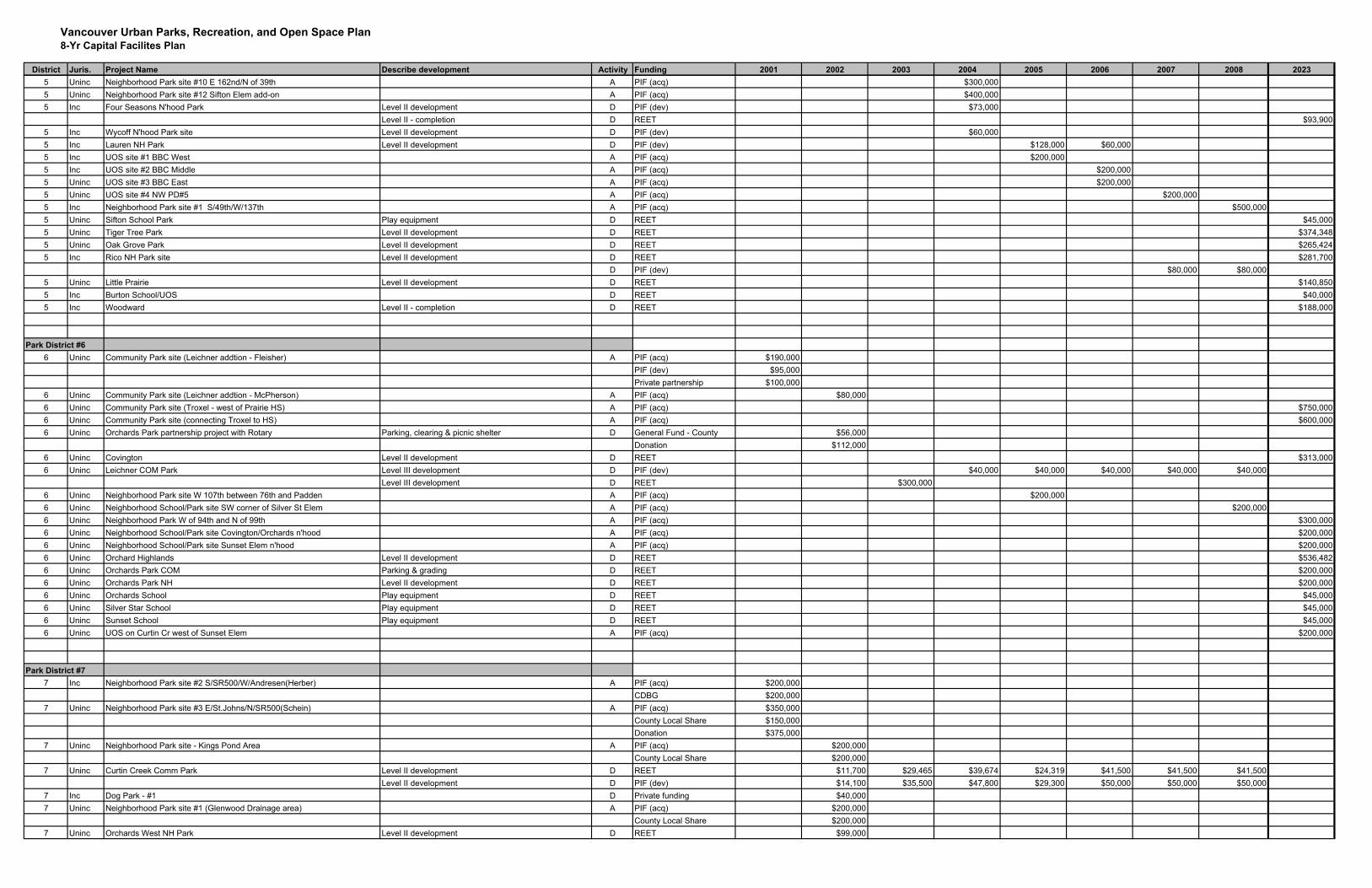
Vancouver Urban Parks, Recreation, and Open Space Plan8-Yr Capital Facilites Plan
District Juris. Project Name Describe development Activity Funding 2001 2002 2003 2004 2005 2006 2007 2008 20235 Uninc Neighborhood Park site #10 E 162nd/N of 39th A PIF (acq) $300,0005 Uninc Neighborhood Park site #12 Sifton Elem add-on A PIF (acq) $400,0005 Inc Four Seasons N'hood Park Level II development D PIF (dev) $73,000
Level II - completion D REET $93,9005 Inc Wycoff N'hood Park site Level II development D PIF (dev) $60,0005 Inc Lauren NH Park Level II development D PIF (dev) $128,000 $60,0005 Inc UOS site #1 BBC West A PIF (acq) $200,0005 Inc UOS site #2 BBC Middle A PIF (acq) $200,0005 Uninc UOS site #3 BBC East A PIF (acq) $200,0005 Uninc UOS site #4 NW PD#5 A PIF (acq) $200,0005 Inc Neighborhood Park site #1 S/49th/W/137th A PIF (acq) $500,0005 Uninc Sifton School Park Play equipment D REET $45,0005 Uninc Tiger Tree Park Level II development D REET $374,3485 Uninc Oak Grove Park Level II development D REET $265,4245 Inc Rico NH Park site Level II development D REET $281,700
D PIF (dev) $80,000 $80,0005 Uninc Little Prairie Level II development D REET $140,8505 Inc Burton School/UOS D REET $40,0005 Inc Woodward Level II - completion D REET $188,000
Park District #66 Uninc Community Park site (Leichner addtion - Fleisher) A PIF (acq) $190,000
PIF (dev) $95,000Private partnership $100,000
6 Uninc Community Park site (Leichner addtion - McPherson) A PIF (acq) $80,0006 Uninc Community Park site (Troxel - west of Prairie HS) A PIF (acq) $750,0006 Uninc Community Park site (connecting Troxel to HS) A PIF (acq) $600,0006 Uninc Orchards Park partnership project with Rotary Parking, clearing & picnic shelter D General Fund - County $56,000
Donation $112,0006 Uninc Covington Level II development D REET $313,0006 Uninc Leichner COM Park Level III development D PIF (dev) $40,000 $40,000 $40,000 $40,000 $40,000
Level III development D REET $300,0006 Uninc Neighborhood Park site W 107th between 76th and Padden A PIF (acq) $200,0006 Uninc Neighborhood School/Park site SW corner of Silver St Elem A PIF (acq) $200,0006 Uninc Neighborhood Park W of 94th and N of 99th A PIF (acq) $300,0006 Uninc Neighborhood School/Park site Covington/Orchards n'hood A PIF (acq) $200,0006 Uninc Neighborhood School/Park site Sunset Elem n'hood A PIF (acq) $200,0006 Uninc Orchard Highlands Level II development D REET $536,4826 Uninc Orchards Park COM Parking & grading D REET $200,0006 Uninc Orchards Park NH Level II development D REET $200,0006 Uninc Orchards School Play equipment D REET $45,0006 Uninc Silver Star School Play equipment D REET $45,0006 Uninc Sunset School Play equipment D REET $45,0006 Uninc UOS on Curtin Cr west of Sunset Elem A PIF (acq) $200,000
Park District #77 Inc Neighborhood Park site #2 S/SR500/W/Andresen(Herber) A PIF (acq) $200,000
CDBG $200,0007 Uninc Neighborhood Park site #3 E/St.Johns/N/SR500(Schein) A PIF (acq) $350,000
County Local Share $150,000Donation $375,000
7 Uninc Neighborhood Park site - Kings Pond Area A PIF (acq) $200,000County Local Share $200,000
7 Uninc Curtin Creek Comm Park Level II development D REET $11,700 $29,465 $39,674 $24,319 $41,500 $41,500 $41,500Level II development D PIF (dev) $14,100 $35,500 $47,800 $29,300 $50,000 $50,000 $50,000
7 Inc Dog Park - #1 D Private funding $40,0007 Uninc Neighborhood Park site #1 (Glenwood Drainage area) A PIF (acq) $200,000
County Local Share $200,0007 Uninc Orchards West NH Park Level II development D REET $99,000
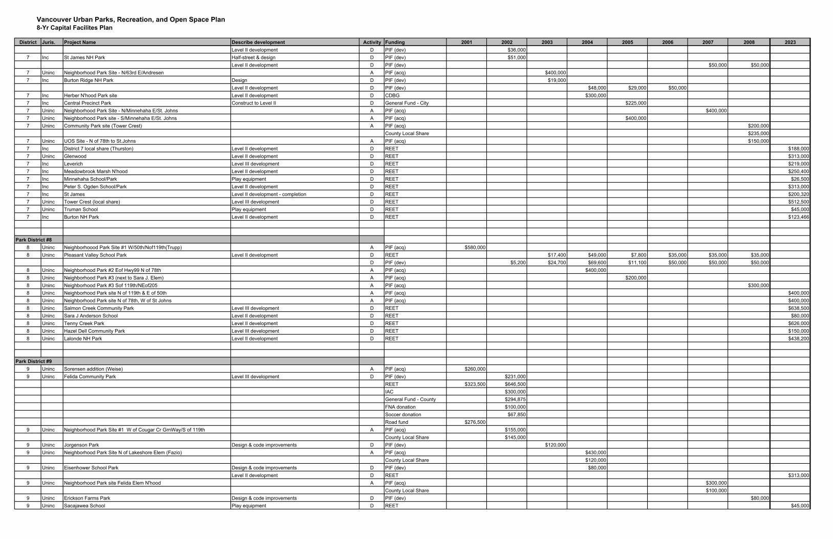
Vancouver Urban Parks, Recreation, and Open Space Plan8-Yr Capital Facilites Plan
District Juris. Project Name Describe development Activity Funding 2001 2002 2003 2004 2005 2006 2007 2008 2023Level II development D PIF (dev) $36,000
7 Inc St James NH Park Half-street & design D PIF (dev) $51,000Level II development D PIF (dev) $50,000 $50,000
7 Uninc Neighborhood Park Site - N/63rd E/Andresen A PIF (acq) $400,0007 Inc Burton Ridge NH Park Design D PIF (dev) $19,000
Level II development D PIF (dev) $48,000 $29,000 $50,0007 Inc Herber N'hood Park site Level II development D CDBG $300,0007 Inc Central Precinct Park Construct to Level II D General Fund - City $225,0007 Uninc Neighborhood Park Site - N/Minnehaha E/St. Johns A PIF (acq) $400,0007 Uninc Neighborhood Park site - S/Minnehaha E/St. Johns A PIF (acq) $400,0007 Uninc Community Park site (Tower Crest) A PIF (acq) $200,000
County Local Share $235,0007 Uninc UOS Site - N of 78th to St.Johns A PIF (acq) $150,0007 Inc District 7 local share (Thurston) Level II development D REET $188,0007 Uninc Glenwood Level II development D REET $313,0007 Inc Leverich Level III development D REET $219,0007 Inc Meadowbrook Marsh N'hood Level II development D REET $250,4007 Inc Minnehaha School/Park Play equipment D REET $26,5007 Inc Peter S. Ogden School/Park Level II development D REET $313,0007 Inc St James Level II development - completion D REET $200,3207 Uninc Tower Crest (local share) Level III development D REET $512,5007 Uninc Truman School Play equipment D REET $45,0007 Inc Burton NH Park Level II development D REET $123,466
Park District #88 Uninc Neighborhoood Park Site #1 W/50th/Nof119th(Trupp) A PIF (acq) $580,0008 Uninc Pleasant Valley School Park Level II development D REET $17,400 $49,000 $7,800 $35,000 $35,000 $35,000
D PIF (dev) $5,200 $24,700 $69,600 $11,100 $50,000 $50,000 $50,0008 Uninc Neighborhood Park #2 Eof Hwy99 N of 78th A PIF (acq) $400,0008 Uninc Neighborhood Park #3 (next to Sara J. Elem) A PIF (acq) $200,0008 Uninc Neighborhood Park #3 Sof 119th/NEof205 A PIF (acq) $300,0008 Uninc Neighborhood Park site N of 119th & E of 50th A PIF (acq) $400,0008 Uninc Neighborhood Park site N of 78th, W of St Johns A PIF (acq) $400,0008 Uninc Salmon Creek Community Park Level III development D REET $638,5008 Uninc Sara J Anderson School Level II development D REET $80,0008 Uninc Tenny Creek Park Level II development D REET $626,0008 Uninc Hazel Dell Community Park Level III development D REET $150,0008 Uninc Lalonde NH Park Level II development D REET $438,200
Park District #99 Uninc Sorensen addition (Weise) A PIF (acq) $260,0009 Uninc Felida Community Park Level III development D PIF (dev) $231,000
REET $323,500 $646,500IAC $300,000General Fund - County $294,875FNA donation $100,000Soccer donation $67,850Road fund $276,500
9 Uninc Neighborhood Park Site #1 W of Cougar Cr GrnWay/S of 119th A PIF (acq) $155,000County Local Share $145,000
9 Uninc Jorgenson Park Design & code improvements D PIF (dev) $120,0009 Uninc Neighborhood Park Site N of Lakeshore Elem (Fazio) A PIF (acq) $430,000
County Local Share $120,0009 Uninc Eisenhower School Park Design & code improvements D PIF (dev) $80,000
Level II development D REET $313,0009 Uninc Neighborhood Park site Felida Elem N'hood A PIF (acq) $300,000
County Local Share $100,0009 Uninc Erickson Farms Park Design & code improvements D PIF (dev) $80,0009 Uninc Sacajawea School Play equipment D REET $45,000
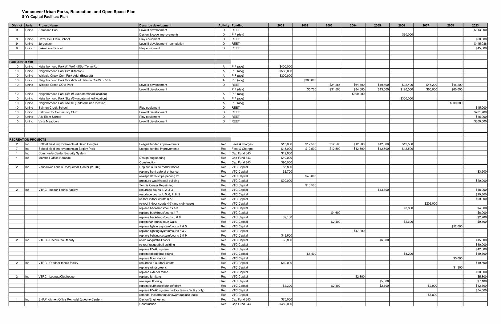
Vancouver Urban Parks, Recreation, and Open Space Plan8-Yr Capital Facilites Plan
District Juris. Project Name Describe development Activity Funding 2001 2002 2003 2004 2005 2006 2007 2008 20239 Uninc Sorensen Park Level II development D REET $313,000
Design & code improvements D PIF (dev) $80,0009 Uninc Hazel Dell Elem School Play equipment D REET $60,0009 Uninc Jorgenson Level II development - completion D REET $445,0869 Uninc Lakeshore School Play equipment D REET $45,000
Park District #1010 Uninc Neighborhood Park #1 Wof I-5/Sof TennyRd A PIF (acq) $400,00010 Uninc Neighborhood Park Site (Stanton) A PIF (acq) $530,00010 Uninc Whipple Creek Com Park Add (Bowcutt) A PIF (acq) $300,00010 Uninc Neighborhood Park Site #2 N of Salmon Crk/W of 50th A PIF (acq) $300,00010 Uninc Whipple Creek COM Park Level II development D REET $24,255 $64,800 $10,400 $92,400 $46,200 $46,200
Level II development PIF (dev) $5,700 $31,500 $84,600 $13,600 $120,000 $60,000 $60,00010 Uninc Neighborhood Park Site #4 (undetermined location) A PIF (acq) $300,00010 Uninc Neighborhood Park Site #5 (undetermined location) A PIF (acq) $300,00010 Uninc Neighborhood Park site #6 (undetermined location) A PIF (acq) $300,00010 Uninc Salmon Creek School Play equipment D REET $45,00010 Uninc Salmon Crk Community Club Level II development D REET $281,70010 Uninc Alki Elem School Play equipment D REET $45,00010 Uninc Vista Meadows Level II development D REET $300,000
RECREATION PROJECTS2 Inc Softball field improvements at David Douglas League funded improvements Rec Fees & charges $13,000 $12,500 $12,500 $12,500 $12,500 $12,5007 Inc Softball field improvements at Bagley Park League funded improvements Rec Fees & Charges $13,000 $12,500 $12,500 $12,500 $12,500 $12,5001 Inc Community Center Security System Rec Cap Fund 343 $12,0001 Inc Marshall Office Remodel Design/engineering Rec Cap Fund 343 $10,000
Construction Rec Cap Fund 343 $90,0002 Inc Vancouver Tennis Racquetball Center (VTRC) Replace outside reader-board Rec VTC Capital $3,800
replace front gate at entrance Rec VTC Capital $2,700 $3,900re-asphalt/re-stripe parking lot Rec VTC Capital $40,000pressure-wash/reseal building Rec VTC Capital $20,000 $20,000Tennis Center Repainting Rec VTC Capital $16,500
2 Inc VTRC - Indoor Tennis Facility resurface courts 1, 2, & 3 Rec VTC Capital $13,800 $18,000resurface courts 4, 5, 6, 7, 8, 9 Rec VTC Capital $29,300re-roof indoor courts 8 & 9 Rec VTC Capital $99,000re-roof indoor courts 4-7 (and clubhouse) Rec VTC Capital $203,000replace backdrops/courts 1-3 Rec VTC Capital $3,800 $4,900replace backdrops/courts 4-7 Rec VTC Capital $4,600 $6,000replace backdrops/courts 8 & 9 Rec VTC Capital $2,100 $2,700repaint far tennis court walls Rec VTC Capital $2,400 $2,600 $9,400replace lighting system/courts 4 & 5 Rec VTC Capital $52,000replace lighting system/courts 6 & 7 Rec VTC Capital $47,200replace lighting system/courts 8 & 9 Rec VTC Capital $43,600
2 Inc VTRC - Racquetball facility re-do racquetball floors Rec VTC Capital $5,800 $6,500 $15,500re-roof racquetball building Rec VTC Capital $50,000replace HVAC system Rec VTC Capital $42,000repaint racquetball courts Rec VTC Capital $7,400 $8,200 $19,500replace floor - lobby Rec VTC Capital $5,000
2 Inc VTRC - Outdoor tennis facility resurface 4 outdoor courts Rec VTC Capital $60,000 $19,500replace windscreens Rec VTC Capital $1,300replace exterior fence Rec VTC Capital $20,000
2 Inc VTRC - Lounge/Clubhouse replace furniture Rec VTC Capital $2,300 $5,800re-carpet flooring Rec VTC Capital $5,800 $7,100repaint clubhouse/lounge/lobby Rec VTC Capital $2,300 $2,400 $2,600 $2,900 $12,500replace HVAC system (Indoor tennis facility only) Rec VTC Capital $54,000remodel lockerrooms/showers/replace locks Rec VTC Capital $7,800
1 Inc SNAP Kitchen/Office Remodel (Luepke Center) Design/Engineering Rec Cap Fund 343 $75,000Construction Rec Cap Fund 343 $450,000
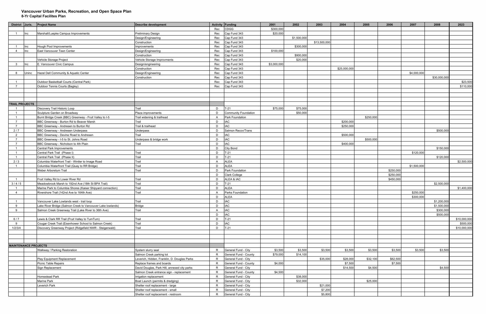
Vancouver Urban Parks, Recreation, and Open Space Plan8-Yr Capital Facilites Plan
District Juris. Project Name Describe development Activity Funding 2001 2002 2003 2004 2005 2006 2007 2008 2023Rec CDGG $300,000
1 Inc Marshall/Luepke Campus Improvements Preliminary Design Rec Cap Fund 343 $20,000Design/Engineering Rec Cap Fund 343 $1,500,000Construction Rec Cap Fund 343 $13,500,000
1 Inc Hough Pool Improvements Improvements Rec Cap Fund 343 $300,0004 Inc East Vancouver Teen Center Design/Engineering Rec Cap Fund 343 $100,000
Construction Rec Cap Fund 343 $900,000Vehicle Storage Project Vehicle Storage Improvments Rec Cap Fund 343 $20,000
3 Inc E. Vancouver Civic Campus Design/engineering Rec Cap Fund 343 $3,000,000Construction Rec Cap Fund 343 $25,000,000
8 Uninc Hazel Dell Community & Aquatic Center Design/Engineering Rec Cap Fund 343 $4,000,000Construction Rec Cap Fund 343 $30,000,000
1 Outdoor Basketball Courts (Central Park) Rec Cap Fund 343 $23,5007 Outdoor Tennis Courts (Bagley) Rec Cap Fund 343 $110,000
TRAIL PROJECTS1 Discovery Trail Historic Loop Trail D T-21 $75,000 $75,0001 Sculpture Garden on Broadway Plaza improvements D Community Foundation $50,0001 Burnt Bridge Creek (BBC) Greenway - Fruit Valley to I-5 Trail widening & trailhead A Park Foundation $250,0007 BBC Greenway - Burton Rd to Beaver Marsh Trail D IAC $200,0007 BBC Greenway - Andresen to Burton Rd Trail & trailhead D IAC $250,000
2 / 7 BBC Greenway - Andresen Underpass Underpass D Salmon Recov/Trans $500,0002 BBC Greenway - Devine Road to Andresen Trail D IAC $500,0007 BBC Greenway - I-5 to St. Johns Road Underpass & bridge work D IAC $500,0007 BBC Greenway - Nicholson to 4th Plain Trail D IAC $400,0001 Central Park Improvements D City Bond $150,0001 Central Park Trail (Phase I) Trail D T-21 $120,0001 Central Park Trail (Phase II) Trail D T-21 $120,000
2 / 3 Columbia Waterfront Trail - Wintler to Image Road Trail A ALEA $2,500,0001 Columbia Waterfront Trail (Quay to RR Bridge) Trail D ALEA $1,500,000
Weber Arboretum Trail Trail D Park Foundation $250,000D Clark College $250,000
1 Fruit Valley Rd to Lower River Rd Trail D ALEA & IAC $450,0003 / 4 / 5 Meadowbrook Marsh to 192nd Ave (18th St BPA Trail) Trail D T-21 $2,500,000
1 Marine Park to Columbia Shores (Kaiser Shipyard connection) Trail D ALEA $1,400,0004 Rivershore Trail (142nd Ave to 164th Ave) Trail A Parks Foundation $250,000
D ALEA $300,0001 Vancouver Lake Lowlands west - trail loop Trail D IAC $1,200,0009 Lake River Bridge (Salmon Creek to Vancouver Lake lowlands) Bridge D IAC $1,500,0009 Salmon Creek Greenway Trail (Lake River to 36th Ave) Trail A IAC $300,000
D IAC $500,0006 / 7 Lewis & Clark RR Trail (Fruit Valley to TumTum) Trail D T-21 $10,000,000
9 Cougar Creek Trail (Eisenhower School to Salmon Creek) Trail D IAC $500,0001/2/3/4 Discovery Greenway Project (Ridgefield NWR - Steigerwald) Trail D T-21 $10,000,000
MAINTENANCE PROJECTSWalkway / Parking Restoration System slurry seal R General Fund - City $3,500 $3,500 $3,500 $3,500 $3,500 $3,500 $3,500 $3,500
Salmon Creek parking lot R General Fund - County $79,000 $14,100Play Equipment Replacement Leverich, Hidden, Franklin, D. Douglas Parks R General Fund - City $35,000 $28,000 $32,100 $62,500Picnic Table Repairs Replace frames and boards R General Fund - County $4,000 $7,500 $7,500Sign Replacement David Douglas, Park Hill, annexed city parks R General Fund - City $14,500 $4,500 $4,500
Salmon Creek entrance sign - replacement R General Fund - County $4,500Homestead Park Irrigation replacement R General Fund - City $38,000Marine Park Boat Launch (permits & dredging) R General Fund - City $32,000 $25,000Leverich Park Shelter roof replacement - large R General Fund - City $21,000
Shelter roof replacement - small R General Fund - City $7,200Shelter roof replacement - restroom R General Fund - City $5,800
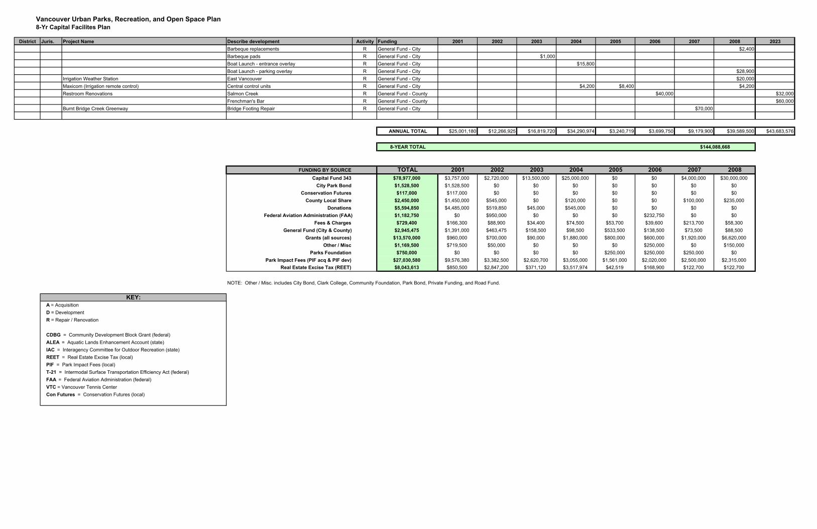
Vancouver Urban Parks, Recreation, and Open Space Plan8-Yr Capital Facilites Plan
District Juris. Project Name Describe development Activity Funding 2001 2002 2003 2004 2005 2006 2007 2008 2023Barbeque replacements R General Fund - City $2,400Barbeque pads R General Fund - City $1,000Boat Launch - entrance overlay R General Fund - City $15,800Boat Launch - parking overlay R General Fund - City $28,900
Irrigation Weather Station East Vancouver R General Fund - City $20,000Maxicom (Irrigation remote control) Central control units R General Fund - City $4,200 $8,400 $4,200Restroom Renovations Salmon Creek R General Fund - County $40,000 $32,000
Frenchman's Bar R General Fund - County $60,000Burnt Bridge Creek Greenway Bridge Footing Repair R General Fund - City $70,000
ANNUAL TOTAL $25,001,180 $12,266,925 $16,819,720 $34,290,974 $3,240,719 $3,699,750 $9,179,900 $39,589,500 $43,683,576
8-YEAR TOTAL
FUNDING BY SOURCE TOTAL 2001 2002 2003 2004 2005 2006 2007 2008Capital Fund 343 $78,977,000 $3,757,000 $2,720,000 $13,500,000 $25,000,000 $0 $0 $4,000,000 $30,000,000
City Park Bond $1,528,500 $1,528,500 $0 $0 $0 $0 $0 $0 $0Conservation Futures $117,000 $117,000 $0 $0 $0 $0 $0 $0 $0
County Local Share $2,450,000 $1,450,000 $545,000 $0 $120,000 $0 $0 $100,000 $235,000Donations $5,594,850 $4,485,000 $519,850 $45,000 $545,000 $0 $0 $0 $0
Federal Aviation Administration (FAA) $1,182,750 $0 $950,000 $0 $0 $0 $232,750 $0 $0Fees & Charges $729,400 $166,300 $88,900 $34,400 $74,500 $53,700 $39,600 $213,700 $58,300
General Fund (City & County) $2,945,475 $1,391,000 $463,475 $158,500 $98,500 $533,500 $138,500 $73,500 $88,500Grants (all sources) $13,570,000 $960,000 $700,000 $90,000 $1,880,000 $800,000 $600,000 $1,920,000 $6,620,000
Other / Misc $1,169,500 $719,500 $50,000 $0 $0 $0 $250,000 $0 $150,000Parks Foundation $750,000 $0 $0 $0 $0 $250,000 $250,000 $250,000 $0
Park Impact Fees (PIF acq & PIF dev) $27,030,580 $9,576,380 $3,382,500 $2,620,700 $3,055,000 $1,561,000 $2,020,000 $2,500,000 $2,315,000Real Estate Excise Tax (REET) $8,043,613 $850,500 $2,847,200 $371,120 $3,517,974 $42,519 $168,900 $122,700 $122,700
NOTE: Other / Misc. includes City Bond, Clark College, Community Foundation, Park Bond, Private Funding, and Road Fund.
A = Acquisition D = DevelopmentR = Repair / Renovation
CDBG = Community Development Block Grant (federal)ALEA = Aquatic Lands Enhancement Account (state)IAC = Interagency Committee for Outdoor Recreation (state)REET = Real Estate Excise Tax (local)PIF = Park Impact Fees (local)T-21 = Intermodal Surface Transportation Efficiency Act (federal)FAA = Federal Aviation Administration (federal)VTC = Vancouver Tennis CenterCon Futures = Conservation Futures (local)
$144,088,668
KEY: