Embed Size (px)
Citation preview
Dynamics of the Structuring Vectors of Geographical
Landscapes in Bucovina, Romania
Viorel CHIRIŢĂ1, Carmen BĂDĂLUŢĂ1, Viorica NAGAVCIUC 1 1 “Ştefan cel Mare” University, Faculty of History and Geography, Department of Geography, Suceava, ROMANIA
E-mail: [email protected]
K e y w o r d s: landscape, basin, Soloneţ, lines, emerging, dynamic, economic cycles
A B S T R A C T
1. INTRODUCTION
The development of economic activities in a
region such as Bukovina has been conditioned by a
series of social and historical processes reflected
territorially at the level of geographical landscapes [1].
From 1775 to 1918, when Bukovina was a
duchy of the Austro-Hungarian Empire [1], [2], there
was a sequence of economic cycles typical of mining, of
logging and of soil utilization for agriculture, taking
place in separate or overlapping periods, across most of
the province or only in certain areas, depending on
accessibility, construction of roads and subsequently
railway [3a].
Obviously, this succession of favouring factors
and conditions reflected on the social relationship
component in the area and on the organisation of space
and of the geographical landscape.
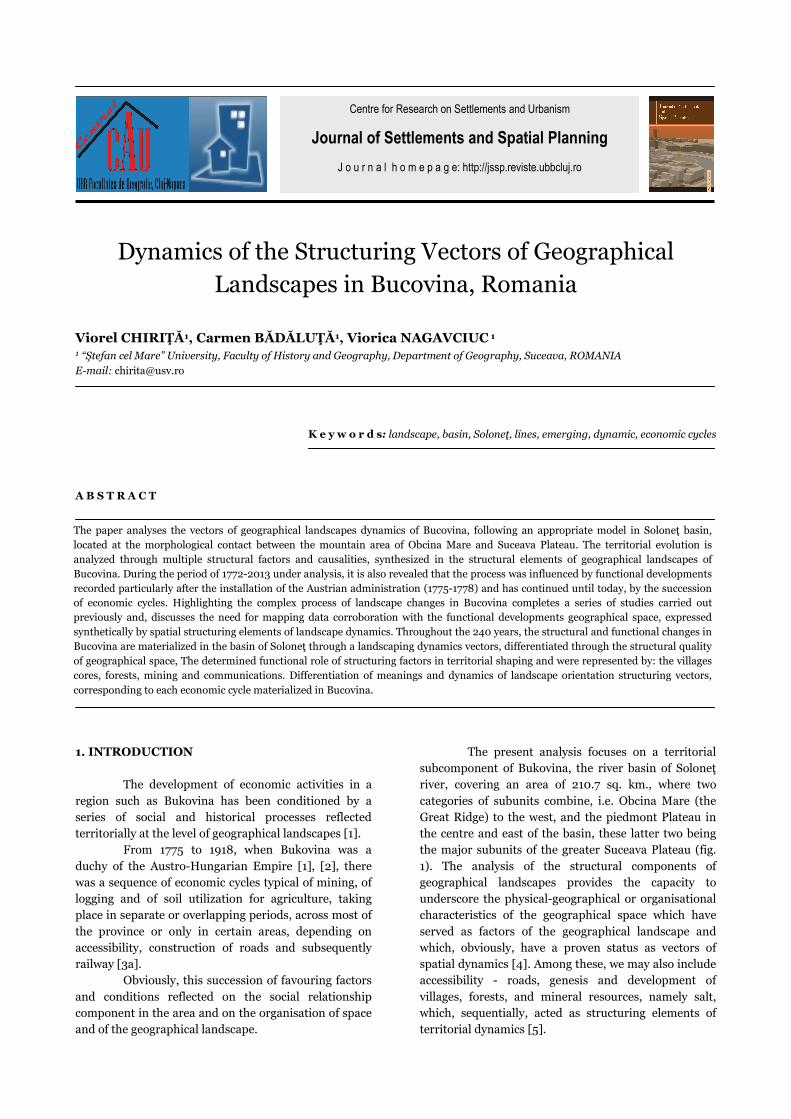
The present analysis focuses on a territorial
subcomponent of Bukovina, the river basin of Soloneţ
river, covering an area of 210.7 sq. km., where two
categories of subunits combine, i.e. Obcina Mare (the
Great Ridge) to the west, and the piedmont Plateau in
the centre and east of the basin, these latter two being
the major subunits of the greater Suceava Plateau (fig.
1). The analysis of the structural components of
geographical landscapes provides the capacity to
underscore the physical-geographical or organisational
characteristics of the geographical space which have
served as factors of the geographical landscape and
which, obviously, have a proven status as vectors of
spatial dynamics [4]. Among these, we may also include
accessibility - roads, genesis and development of
villages, forests, and mineral resources, namely salt,
which, sequentially, acted as structuring elements of
territorial dynamics [5].
Centre for Research on Settlements and Urbanism
Journal of Settlements and Spatial Planning
J o u r n a l h o m e p a g e: http://jssp.reviste.ubbcluj.ro
The paper analyses the vectors of geographical landscapes dynamics of Bucovina, following an appropriate model in Soloneţ basin,
located at the morphological contact between the mountain area of Obcina Mare and Suceava Plateau. The territorial evolution is
analyzed through multiple structural factors and causalities, synthesized in the structural elements of geographical landscapes of
Bucovina. During the period of 1772-2013 under analysis, it is also revealed that the process was influenced by functional developments
recorded particularly after the installation of the Austrian administration (1775-1778) and has continued until today, by the succession
of economic cycles. Highlighting the complex process of landscape changes in Bucovina completes a series of studies carried out
previously and, discusses the need for mapping data corroboration with the functional developments geographical space, expressed
synthetically by spatial structuring elements of landscape dynamics. Throughout the 240 years, the structural and functional changes in
Bucovina are materialized in the basin of Soloneţ through a landscaping dynamics vectors, differentiated through the structural quality
of geographical space, The determined functional role of structuring factors in territorial shaping and were represented by: the villages
cores, forests, mining and communications. Differentiation of meanings and dynamics of landscape orientation structuring vectors,
corresponding to each economic cycle materialized in Bucovina.
Viorel Chiriţă, Carmen Bădăluţă, Viorica Nagavciuc
Journal of Settlements and Spatial Planning, Special Issue, no. 3 (2014) 39-46
40
The questions that arise deal with the key
elements that were fundamental to the evolution of
geographic landscapes, the structuring elements which
generated such dynamics, and, especially, the structural
vectors of the geographical space [10].
Fig. 1. Location of the Soloneţ basin.
The hypothesis of our study was to identify the
structural elements of the appropriate territorial system
Soloneţ Basin to support the geographical landscape
typology and structure their vectors. The stated goal of
the present study is to identify the structuring vectors
that contribute to the dynamics of the landscape, and
how they have evolved, in what direction, in what
manner and with what force, according to the sequence
of business cycles and human resource dynamics, the
reflections of these vectors territorial in emerging
landscape hubs or axes and lines generating the
supports for subsequent developments of geographical
landscapes. Among the goals of the study we also aim to
solve, at least partially, the matrix dilemmas of
landscape dynamics, among the physical and
geographical coordinates of space: river network,
morphological contact, forests and pasture areas, with
the anthropogenic coordinates of space, such as: salt
mines, expanding human habitat and the emerging
communications networks.
2. THEORY AND METHODOLOGY
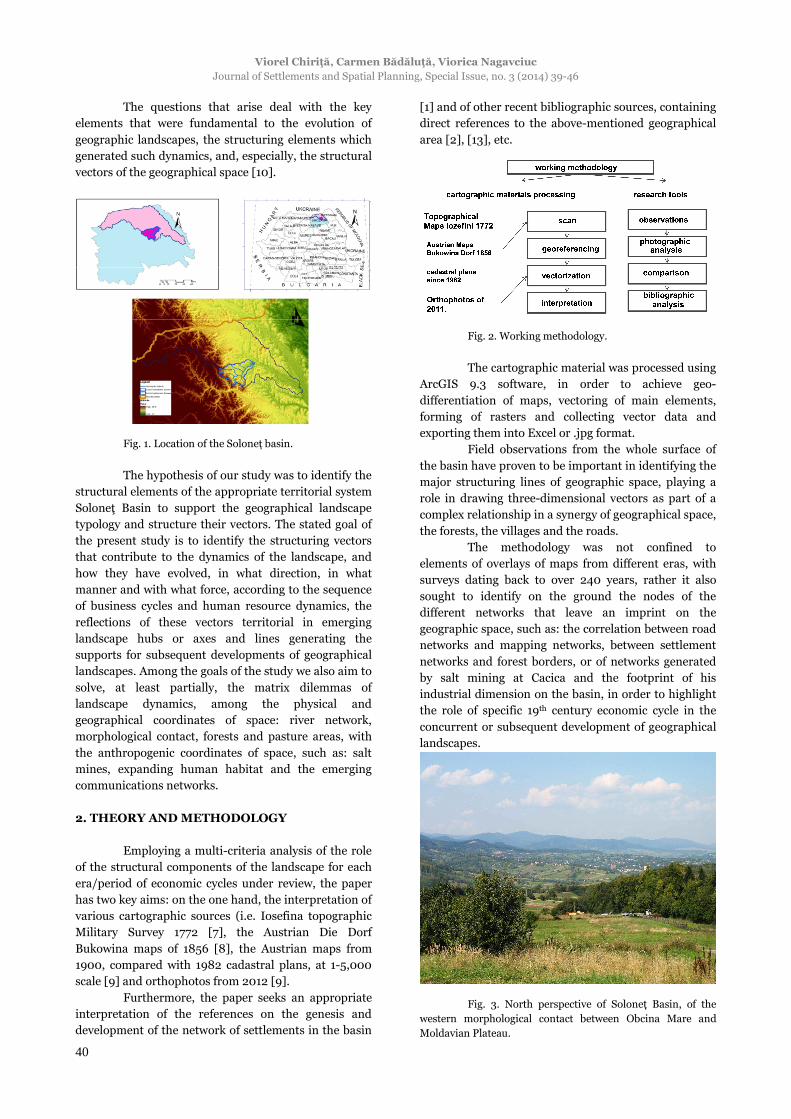
Employing a multi-criteria analysis of the role
of the structural components of the landscape for each
era/period of economic cycles under review, the paper
has two key aims: on the one hand, the interpretation of
various cartographic sources (i.e. Iosefina topographic
Military Survey 1772 [7], the Austrian Die Dorf
Bukowina maps of 1856 [8], the Austrian maps from
1900, compared with 1982 cadastral plans, at 1-5,000
scale [9] and orthophotos from 2012 [9].
Furthermore, the paper seeks an appropriate
interpretation of the references on the genesis and
development of the network of settlements in the basin
[1] and of other recent bibliographic sources, containing
direct references to the above-mentioned geographical
area [2], [13], etc.
Fig. 2. Working methodology.
The cartographic material was processed using
ArcGIS 9.3 software, in order to achieve geo-
differentiation of maps, vectoring of main elements,
forming of rasters and collecting vector data and
exporting them into Excel or .jpg format.
Field observations from the whole surface of
the basin have proven to be important in identifying the
major structuring lines of geographic space, playing a
role in drawing three-dimensional vectors as part of a
complex relationship in a synergy of geographical space,
the forests, the villages and the roads.
The methodology was not confined to
elements of overlays of maps from different eras, with
surveys dating back to over 240 years, rather it also
sought to identify on the ground the nodes of the
different networks that leave an imprint on the
geographic space, such as: the correlation between road
networks and mapping networks, between settlement
networks and forest borders, or of networks generated
by salt mining at Cacica and the footprint of his
industrial dimension on the basin, in order to highlight
the role of specific 19th century economic cycle in the
concurrent or subsequent development of geographical
landscapes.
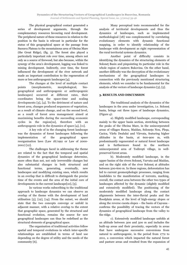
Fig. 3. North perspective of Soloneţ Basin, of the
western morphological contact between Obcina Mare and
Moldavian Plateau.
Dynamics of the Structuring Vectors of Geographical Landscapes in Bucovina, Romania Journal of Settlements and Spatial Planning, Special Issue, no. 3 (2014) 39-46
41
The physical geographical contact generated a
series of development arguments, through the
complementary resources favouring rural development.
The peripheral nature of these resources in relation to the
position in the basin is relevant in particular for the
status of this geographical space at the passage from
Suceava Plateau to the mountainous area of Obcina Mare
(the Great Ridge), (fig. 3). The forest also played a
particularly important role over time, among others not
only as a source of firewood, but also because, within the
synergy of the area’s development, logging was linked to
mining development. Indirectly, over time, the forest
influenced the development of the river network and
made an important contribution to the regeneration of
more or less anthropogenic landscapes [4].
The changes at the level of multiple contact
points (morphometric, morphological, bio-
geographical and anthropogenic or anthropogenic
landscapes) occurred at different rates, their
coordinates being the space-time and scaling
developments [3], [4]. To the detriment of nature and
forest area, changes produced sequences of vegetation,
as a result of climate change, and on the second level,
as a result of forest area management aimed at
maximising benefits during the succeeding economic
cycles in the region[1a], therefore with an
anthropogenic role in the dynamics of space [4], [11].
A key role of in the changing forest landscape
was the dynamics of forest landscapes following the
implementation of the geographical space
reorganisation laws (Law 18/1991 or Law of 2000-
2001) [12].
The challenges faced in addressing the theme
are related to the fact that the temporal and spatial
dynamics of the geographical landscape determine,
more often than not, not only irreversible changes but
also substantial changes in both structural and
functional terms, generating, eventually, new
landscapes and modifying existing ones, which results
in an overlap that is difficult to distinguish the precise
time of the events and the area of the initial core of
developments in the current landscape[10], [5].
In various works subscribing to the traditional
approach to landscape dynamics we can observe an
overlap of the theme with the development of land
utilisation [5], [12], [14]. From the outset, we should
state that the two concepts converge or unfold in
adjacent manner, with a relative overlap to the extent
that geographic space, generated by the structural and
functional evolution, remains the source for new
geographical landscapes can thus be redefined as the
structural elements of geographical space.
The organisation of traditional activities follow
spatial and temporal evolutions in which inter-specific
relationships are established in terms of land use
depending on the degree of utility and the needs of the
community [6].
Many perceptual tests recommended for the
analysis of territorial developments and thus the
dynamics of landscapes, such as implemented
methodological [18] was complemented by correlating
evolutionary elements with dynamic functional
mapping, in order to identify relationship of the
landscape with development as right representation of
the rural territorial systems dynamics.
Another point of difficulty consists in
identifying the dynamics of the structuring elements of
Soloneţ Basin and pinpointing its particular role in the
whole region of eastern Bukovina. On the other hand,
another difficulty was the decryption of the evolutionary
mechanisms of the geographical landscapes in
connection with the previously mentioned structuring
elements, which we consider to be fundamental for the
analysis of the vectors of landscape dynamics [3], [5].
3. RESULTS AND DISCUSSION
The traditional analysis of the dynamics of the
landscapes in the area under investigation, i.e. Soloneţ
basin, brings out three types of landscape dynamics,
(Figure 4):
a). Slightly modified landscape, corresponding
mainly to the upper basin section, stretching between
the peaks of the Obcina Mare, in the unincorporated
areas of villages Runcu, Maidan, Soloneţu Nou, Pleşa,
Cacica, Vârfu Dealului and Vârvata, featuring higher
altitudes in the basin, at 600-900 m, with
predominantly regenerated or natural forest landscape
and is furthermore found in the northern
unincorporated area of Todireşti village, in well-
preserved forest areas.
b). Moderately modified landscape, in the
upper basins of the rivers Soloneţ, Varvata and Maidan,
and on the right side of the river Soloneţ at altitudes
between 500-600 m. In these regions, deforestation has
led to current geomorphologic processes, ranging from
landslides to the manifestation of torrents, marking,
overall, the contact area between the other two types of
landscapes affected by the dynamic (slightly modified
and extensively modified). The positioning of the
moderately modified landscape along the contact
alignments between the inter-fluvial peaks and the
floodplain areas, at the level of high-energy slopes or
along the reverse cuesta slopes – the basin of Caşvana -
confirms the possibility of tracing the vectors of the
dynamics of geographical landscape from the valley to
the ridge.
c). Extensively modified landscape unfolds at
an altitude between 300 and 500 m and includes the
built-up areas and their proximity, especially in areas
that have undergone successive conversions from
natural to anthropogenic, in the period from 1772 to
2011, a conversion which impacted the natural forest
and pasture areas and resulted from the expansion of

Viorel Chiriţă, Carmen Bădăluţă, Viorica Nagavciuc
Journal of Settlements and Spatial Planning, Special Issue, no. 3 (2014) 39-46
42
the human habitat and the development linked to salt
mining.
Fig. 4. Map of the dynamics of geographical
landscapes and of landscape types.
3.1. Types of landscapes
The main types of geographical landscapes
existing today in the Soloneţ river basin are: forest
landscapes (with different roles and types of habitats
and biodiversity), the habitation cultural landscape
(those parts of the village that retain the organisational
elements of a convergent rural area, mixed cultural,
Romanian and Austrian), and the landscape specific to
dissociated countryside housing, sacred landscape and
agricultural landscape [10], [18].
Fig. 5. Todirești village - types of different rural
cultural landscape.
Forest landscape covers the slightly modified
landscape type, where the structuring element is the
forest, yet with difficult to perceive changes as regards
its structure and composition.
The habitation cultural landscape overlaps
built-up village areas, forming territories with a strong
footprint of the communities that inhabited them and is
visible in all areas, but mostly in Cacica, Pârteştii de
Sus, Runcu, Soloneţul Nou, Botoşana, Cajvana,
Todireşti and Părhăuţi.
The sacred rural landscape is defined by the
values of cultural heritage, which became more diverse
owing to the cultural infusion during the Austro-
Hungarian occupation: Catholic sacred landscape
represented by the Greco-Roman basilica of Minor and
the Lourdes grotto in Cacica and the Orthodox sacred
landscape reflected by outstanding architectural
ensembles, part of the national cultural heritage, such
as the church dedicated to All Saints’ Sunday in
Părhăuţi, the wooden churches in Todireşti (1781) and
Pârteştii de Sus (1779) dedicated to the Holy Archangels
Michael and Gabriel, wooden church the Assumption in
Comăneşti (1772), the wooden church St. Dimitrios in
Botoşana, built in 1810.
Agricultural landscape accompanies the
habitation and forest landscapes, occupying most of the
Soloneţ basin area and used to be one of the landscapes
with a strong dynamic and rapid expansion in the 18th
and 19th centuries. At the first impact with the rural
space, the landscape gives a touch of originality to all
the elements that define the mental space in the Soloneţ
basin.
Fig. 6. House of traditional architecture in Cacica.
The traditional approach is complemented by
the contemporary approach, which is based on a multi-
criteria analysis of the geographical landscapes and
crosschecking it with the sequence of economic cycles
unfolding in the basin. The analysis that we performed
regards the types of landscapes and especially the on
spatial-temporal dynamics delivered the following
categories of structuring elements of geographical
landscapes, to which correspond, to a relative degree,
the structuring vector of landscape dynamics.
3.2. The structuring elements of landscape
Discussions on the structuring nature of the
landscape involve identifying those traits that have
favoured or conditioned in advance a certain type of
dynamics of geographic landscapes. From this point of
view, the morphological contact between the two types
of units and the river network of Soloneţ Basin serve as
conditions of landscape dynamics, while the favouring
factors of landscape dynamics include: the forest, salt
mining, road and accessibility expansion, human
habitat and its functionality, playing the role of
Dynamics of the Structuring Vectors of Geographical Landscapes in Bucovina, Romania Journal of Settlements and Spatial Planning, Special Issue, no. 3 (2014) 39-46
43
structural elements and favouring factors of the
dynamics of landscapes.
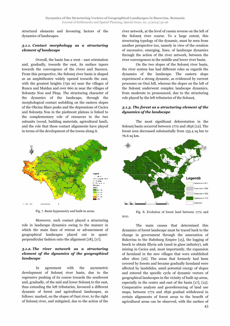
3.1.1. Contact morphology as a structuring
element of landscape
Overall, the basin has a west - east orientation
and, gradually, towards the east, its surface tapers
towards the convergence of the rivers and Suceava.
From this perspective, the Soloneţ river basin is shaped
as an amphitheatre widely opened towards the east,
with the greatest heights (750 m) near the villages of
Runcu and Maidan and over 660 m near the villages of
Soloneţu Nou and Pleşa. The structuring character of
the dynamics of the landscape, through the
morphological contact unfolding on the eastern slopes
of the Obcina Mare peaks and the depressions of Cacica
and Soloneţu Nou in the piedmont plateau is linked to
the complementary role of resources in the two
subunits (wood, building materials, agricultural land),
and the role that these contact alignments have played
in terms of the development of the towns along it.
Fig. 7. Basin hypsometry and built-in areas.
Moreover, such contact played a structuring
role in landscape dynamics owing to the manner in
which the main lines of retreat or advancement of
geographical landscapes played out in quasi-
perpendicular fashion onto the alignment [18], [17].
3.1.2. The river network as a structuring
element of the dynamics of the geographical
landscape
In agreement with the asymmetric
development of Soloneţ river basin, due to the
regressive pushing of its course towards the southwest
and, gradually, of the mid and lower Soloneţ to the east,
thus extending the left tributaries, favoured a different
dynamic of forest and agricultural landscapes, as
follows: marked, on the slopes of Oșoi river, to the right
of Soloneţ river, and mitigated, due to the action of the
river network, at the level of cuesta reverse on the left of
the Soloneţ river course. To a large extent, this
structuring typology of the dynamic, must be seen from
another perspective too, namely in view of the creation
of successive, emerging, lines, of landscape dynamics
through the action of the river network, between the
river convergences in the middle and lower river basin.
On the two slopes of the Soloneţ river basin,
the river system has had different roles as regards the
dynamics of the landscape. The eastern slope
experienced a strong dynamic, as evidenced by current
processes on Osoi hill, whereas the slopes on the left of
the Soloneţ underwent complex landscape dynamics,
from moderate to pronounced, due to the structuring
role played by the left tributaries of the Soloneţ.
3.1.3. The forest as a structuring element of the
dynamics of the landscape
The most significant deforestation in the
Soloneţ basin occurred between 1772 and 1856 [12]. The
forest area decreased substantially from 155.4 sq km to
76.6 sq km.
Fig. 8. Evolution of forest land between 1772 and
2011.
The main causes that determined this
dynamics of forest landscape must be traced back to the
change in government through the annexation of
Bukovina to the Habsburg Empire [15], the logging of
beech to obtain Illyria ash (used in glass industry), salt
mining in Cacica and, most importantly, the expansion
of farmland in the new villages that were established
after 1800 [16]. The areas that formerly had been
covered by forests and became gradually farmland were
affected by landslides, amid potential energy of slopes
and entered the specific cycle of dynamic vectors of
geographical landscapes in the vicinity of built-up areas,
especially in the centre and east of the basin [17], [15].
Comparative analysis and georeferencing of land use
maps, between 1772 and 1856 gradual withdrawal in
certain alignments of forest areas to the benefit of
agricultural areas can be observed, with the surface of
Viorel Chiriţă, Carmen Bădăluţă, Viorica Nagavciuc
Journal of Settlements and Spatial Planning, Special Issue, no. 3 (2014) 39-46
44
the latter increasing from 27.1 sq km in 1772 to 68.4 sq
km in 1856, hence a doubling of the areas, while built-
up areas increased from 1.2 sq km to 1.7 sq km during
the same period, following the establishment of new
localities: Runcu, Soloneţu Nou, Cajvana.
In analysing the forest land area, we
considered necessary to subdivide the Soloneţ basin
into 4 sectors, corresponding to the different energies of
the relief and the relationships with networks of
localities.
Fig. 9. Subsectoral division of forest dynamics.
By analysing the three major periods, based on
successive analogies, we were able to decipher the rate
of the dynamics of forest landscape over a year, yielding
the following findings:
Fig. 10. Subsectoral division /rate of forest dynamics
over a year.
The fastest deforestation rate occurred
between 1772 - 1856 throughout the basin [4], especially
in the northern sector of the basin, in the plateau area,
which was more accessible to deforestation operations,
the chief goal being the expansion of the areas of
agricultural land and villages (-5.1) [12], [12a].
Considerably lower values were recorded for all the
other analysed sections, i.e. between -0.7 and -1.7. As
we advance towards the contemporary period, the
lowest rates of deforestation were recorded in the
mountain area in the western basin, the analysis
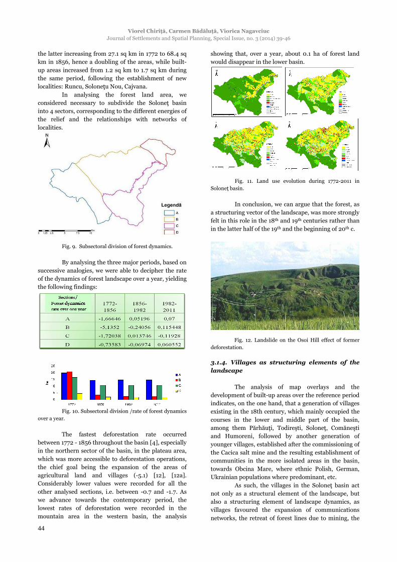
showing that, over a year, about 0.1 ha of forest land
would disappear in the lower basin.
Fig. 11. Land use evolution during 1772-2011 in
Soloneţ basin.
In conclusion, we can argue that the forest, as
a structuring vector of the landscape, was more strongly
felt in this role in the 18th and 19th centuries rather than
in the latter half of the 19th and the beginning of 20th c.
Fig. 12. Landslide on the Osoi Hill effect of former
deforestation.
3.1.4. Villages as structuring elements of the
landscape
The analysis of map overlays and the
development of built-up areas over the reference period
indicates, on the one hand, that a generation of villages
existing in the 18th century, which mainly occupied the
courses in the lower and middle part of the basin,
among them Părhăuţi, Todireşti, Soloneţ, Comăneşti
and Humoreni, followed by another generation of
younger villages, established after the commissioning of
the Cacica salt mine and the resulting establishment of
communities in the more isolated areas in the basin,
towards Obcina Mare, where ethnic Polish, German,
Ukrainian populations where predominant, etc.
As such, the villages in the Soloneţ basin act
not only as a structural element of the landscape, but
also a structuring element of landscape dynamics, as
villages favoured the expansion of communications
networks, the retreat of forest lines due to mining, the
Dynamics of the Structuring Vectors of Geographical Landscapes in Bucovina, Romania Journal of Settlements and Spatial Planning, Special Issue, no. 3 (2014) 39-46
45
development of farm holdings, pastures and hayfields.
Four contributing factors were found to have
contributed to territorial dynamics of villages: valleys,
salt resources, forests and roads. Furthermore, villages
recorded largely regressive territorial development
along the rivers and agglutinative on the cuesta reverse
in the northern central part of the basin and
predominantly with a divergent dynamics in the areas
of Polish settlement or predominantly of the regressive
agglutination in areas of Romanian traditional housing.
Fig. 13. Dynamics vectors of the inhabitable
landscape.
4. CONCLUSION
The analysis of complex structural elements of
geographical landscape and landscape dynamics
indicates that the vectors that subsume the role of the
elements that contributed to the dynamics of
landscapes are generally oriented mainly from north-
east towards south-west and south, with branches
ascending towards the main peaks of the river basin,
confirming that these reflect, above all, the occupation
of space for habitation purposes of space and the
gradual expansion of settlements and of
communications networks.
Fig. 14. Main orientation of the structuring vectors
evolution in Soloneţ basin.
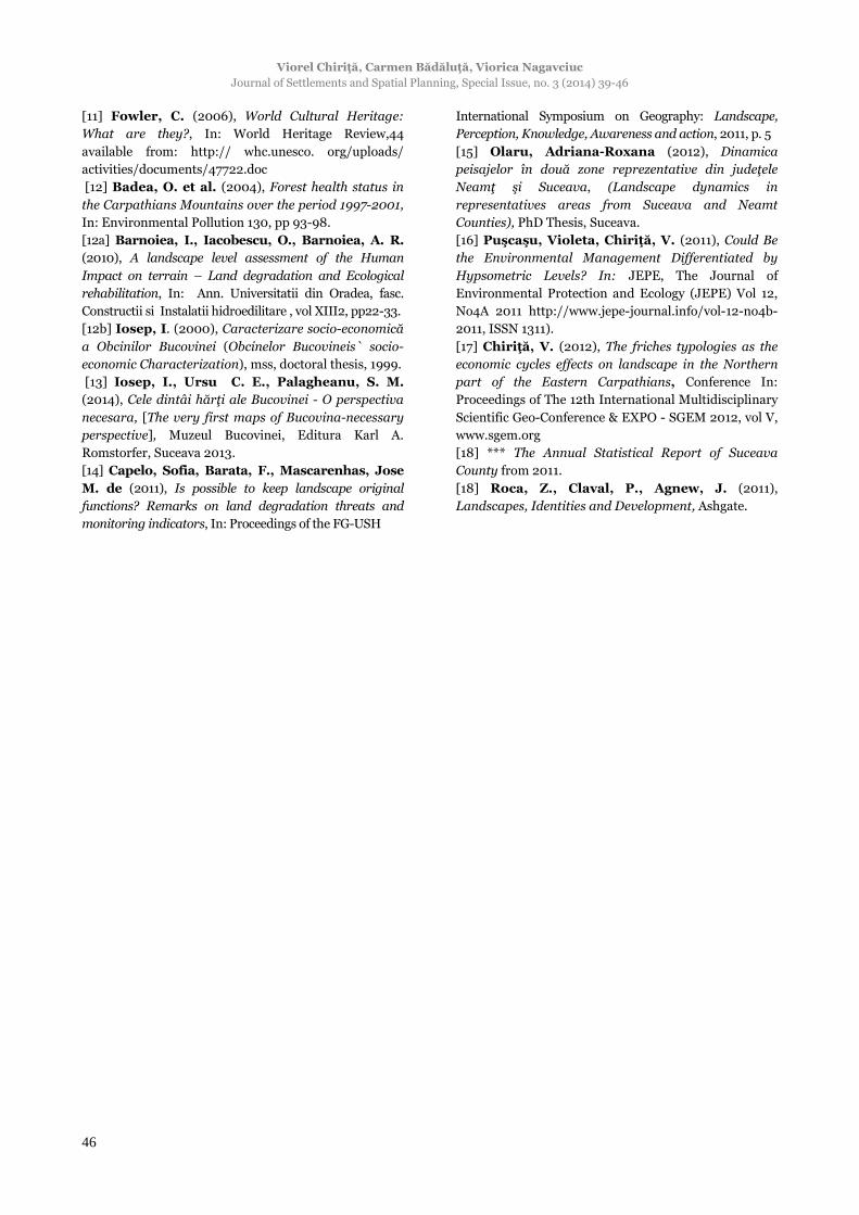
The diagram of structuring vectors of the
dynamics of landscapes in the Soloneţ river basin
exposes four basic categories of vector components:
economic cycles, structural elements, landscape
typologies and structuring vectors.
Fig. 15. Diagram of the structuring vectors.
REFERENCES
[1] *** (1900), Die Bukovina, Fischer. Ed.
[2] Andronic, M. (1997), Evoluţia habitatului uman
în bazinul hidrografic Soloneţ din paleolitc până la
sfârșitul secolului al XVI-lea [The evolution of the
human habitat in the Solonet hydrographical basin
since Paleolitic till the end of the XVI c.], Muzeul
Naţional al Bucovinei Publishing, Suceava.
[3] Chiriţă, V. (2011), The Romanian rural space
tracking trough agriculture morphology reality and
typology of villages hearth, In: Proceedings of The
54th International Scientific Conference, Durable
Agriculture development strategies, Publishing House
“Ion Ionescu de la Brad” Iaşi, 2011, Serie Agronomy,
Vol. 54, nr. 2. [4] Bădăluţă, Carmen, Bistricean, P., Nagavciuc, Viorica (2013), Using GIS techniques in the analysis
of land use in the Soloneţ river catchment betwen 1856
and 2011, In Georeview: Annals of the Stefan cel Mare
University, Geography Series, Chiriţă Viorel, Lupchian
Magda editors, vol no. 2-23/2013.
[5] Ielenicz, M. (1997), Contribuţii la teoria
peisajului, [Contributions on landscape theory], In: rev
Terra, XXVI-XXVII.
[6] Iosep, I. (1972), Căteva consideraţii privind
aşezările omeneşti din Judeţul, [Some consideration
regarding the human settlement in Suceava County],
In: Comunicări şi referate Inst Pedagogic Suceava
[7] Iosep, I., Ursu, C. E., Palagheanu, S. (2011),
Plans der Bukowiner Districts in 72 sections, welche in
denen yahren 1772, 1774, und 1775 , (refunds volume)
Publishing House Romstorfer, Suceava.
[8] *** The Dorf Bukowina Austrian Maps from 1856,
scale 1:280., Suceava County Department of National
Archives.
[9] *** The Cadastral Plans from 1982, scale 1:500.
Suceava County Department of National Archives.
[10] *** Orthophotos from 2011. Suceava County
Department of National Archives.
Viorel Chiriţă, Carmen Bădăluţă, Viorica Nagavciuc
Journal of Settlements and Spatial Planning, Special Issue, no. 3 (2014) 39-46
46
[11] Fowler, C. (2006), World Cultural Heritage:
What are they?, In: World Heritage Review,44
available from: http:// whc.unesco. org/uploads/
activities/documents/47722.doc
[12] Badea, O. et al. (2004), Forest health status in
the Carpathians Mountains over the period 1997-2001,
In: Environmental Pollution 130, pp 93-98.
[12a] Barnoiea, I., Iacobescu, O., Barnoiea, A. R. (2010), A landscape level assessment of the Human
Impact on terrain – Land degradation and Ecological
rehabilitation, In: Ann. Universitatii din Oradea, fasc.
Constructii si Instalatii hidroedilitare , vol XIII2, pp22-33.
[12b] Iosep, I. (2000), Caracterizare socio-economică
a Obcinilor Bucovinei (Obcinelor Bucovineis` socio-
economic Characterization), mss, doctoral thesis, 1999.
[13] Iosep, I., Ursu C. E., Palagheanu, S. M. (2014), Cele dintâi hărţi ale Bucovinei - O perspectiva
necesara, [The very first maps of Bucovina-necessary
perspective], Muzeul Bucovinei, Editura Karl A.
Romstorfer, Suceava 2013.
[14] Capelo, Sofia, Barata, F., Mascarenhas, Jose M. de (2011), Is possible to keep landscape original
functions? Remarks on land degradation threats and
monitoring indicators, In: Proceedings of the FG-USH
International Symposium on Geography: Landscape,
Perception, Knowledge, Awareness and action, 2011, p. 5
[15] Olaru, Adriana-Roxana (2012), Dinamica
peisajelor în două zone reprezentative din judeţele
Neamţ şi Suceava, (Landscape dynamics in
representatives areas from Suceava and Neamt
Counties), PhD Thesis, Suceava.
[16] Puşcaşu, Violeta, Chiriţă, V. (2011), Could Be
the Environmental Management Differentiated by
Hypsometric Levels? In: JEPE, The Journal of
Environmental Protection and Ecology (JEPE) Vol 12,
No4A 2011 http://www.jepe-journal.info/vol-12-no4b-
2011, ISSN 1311). [17] Chiriţă, V. (2012), The friches typologies as the
economic cycles effects on landscape in the Northern
part of the Eastern Carpathians, Conference In:
Proceedings of The 12th International Multidisciplinary
Scientific Geo-Conference & EXPO - SGEM 2012, vol V,
www.sgem.org [18] *** The Annual Statistical Report of Suceava
County from 2011.
[18] Roca, Z., Claval, P., Agnew, J. (2011),
Landscapes, Identities and Development, Ashgate.