Embed Size (px)
Citation preview
1
Vol. I
ABSTRACT
Extension Proposal
LA PALMA BIOSPHERE RESERVE
2
INDEX
Introduction. A biosphere reserve in evolution ..................................... 3
1. Proposed name for the reserve............................................................ 10
2. Country ................................................................................................... 11
3. Fulfilling biosphere reserve functions ................................................. 12
3.1. Conservation function ................................................................ 13
3.2. Development function ................................................................ 15
3.3. Logistic function......................................................................... 18
4. Criteria for the designation ................................................................... 20
4.1. A mosaic of representative ecological systems......................... 21
4.2. Importance for conserving biological diversity ........................... 23
4.3. Sustainable development .......................................................... 24
4.4. Sufficient size to fulfil BR functions ………………………………. 26
4.5. Appropriate zoning..................................................................... 31
3
introduction A BIOSPHERE RESERVE IN EVOLUTION
Background and general rationale for extension
The island of La Palma was the first of the Canary Islands to have a Biosphere Reserve. On
the 30th of June, 1983, the UNESCO declared 511 hectares of the “El Canal y Los Tiles” estate
a Biosphere Reserve. At the time, it was the smallest, but at least, it was the first island
Reserve.
The protected area was situated on the north east slopes of the island of La Palma, in the
borough of San Andres y Sauces. Later on, in 1994, this land was included in the Las Nieves
Nature Park that was created by the Canary Island Natural Spaces Act, Law 12/1994 of 19th of
December.
The protection objective of the original El Canal y Los Tiles Reserve was the Macaronesian
Laurel Forest. But, the role of Biosphere Reserves evolved dramatically to become a pioneering
benchmark of sustainable development. So, despite the undoubted values of this area and their
importance in the Canary Islands as an educational source for conserving and researching
these habitats, the designated area soon became a corset that made it impossible to
appropriately fulfil the three functions that the MAB programmed had laid down for Biosphere
Reserves (conservation, logistics and development). Only two of these aspects could be
adequately addressed in the small area of the original Biosphere Reserve.
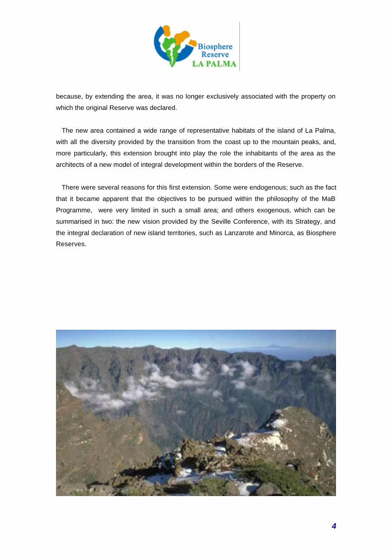
This led to a proposal being made in the 90s, to extend the area under protection. This first
extension was adopted by MaB in 1998, increasing the area of the Reserve to 13,240 hectares;
27 times the size of that emblematic area of the El Canal y Los Tiles estate. In fact, the 511
hectares originally declared a Reserve remain as the core zone of the present Reserve, but the
protected area now encompasses an entire district, from the mountain tops to the coast.
Furthermore, the island of La Palma’s Biosphere Reserve also underwent a change of name,
4
because, by extending the area, it was no longer exclusively associated with the property on
which the original Reserve was declared.
The new area contained a wide range of representative habitats of the island of La Palma,
with all the diversity provided by the transition from the coast up to the mountain peaks, and,
more particularly, this extension brought into play the role the inhabitants of the area as the
architects of a new model of integral development within the borders of the Reserve.
There were several reasons for this first extension. Some were endogenous; such as the fact
that it became apparent that the objectives to be pursued within the philosophy of the MaB
Programme, were very limited in such a small area; and others exogenous, which can be
summarised in two: the new vision provided by the Seville Conference, with its Strategy, and
the integral declaration of new island territories, such as Lanzarote and Minorca, as Biosphere
Reserves.
5
The declaration of a whole island as a Biosphere Reserve was, of course a change of
perspective from the first Reserves, in that it is now understood that in this kind of small, fragile
places with a complicated co-existence between conservation and social and economic
development, the territory cannot be fragmented even more for conservation purposes. On the
contrary, an integral approach has to be articulated for such a complex situation. International
practise has shown that this is evidently one of the characteristics of small and medium-sized
islands, where land and human activities are in constant and ever-changing interaction, making
it very difficult to take areas of a certain size out of their island context.
Furthermore, in the case of La Palma, the management and development advances
generated in the scope of the new reserve, and the MaB Programme strategy quickly started to
have an influence on the rest of the island. In fact, in the last three years, there has been an
assimilation process in which the sustainable development strategies and initiatives, whether or
not they have been generated within the present limits of the Reserve, have adopted initiatives,
plans and programmes that are completely in line with the strategy drawn up for the Biosphere
Reserve.
This phenomenon can be clearly seen in key programmes and initiatives that affect the island
as a whole, but with the premises of the MaB Programme, such as:
• The Leader+ Rural Development Programme, aimed almost exclusively at “revaluing
the natural and cultural resources included in the sites of community interest in the
framework of the Natura 2000 Network”.
• Adopting the Island of La Palma Sustainable Development Plan (La Palma Cabildo –
Island Council).
• The rural tourism strategy established on the island, based on environmental and
cultural innovation, diversification and integration.
• The advances made in the system of public use of natural spaces that have made it
possible to develop an experience that is presently becoming a regional benchmark.
• The recovery of traditional products and the introduction of new environmentally-friendly
methods that will enable La Palma to become a model for catalysing traditional
productive sectors, associated with landscape conservation and production by re-
valuing their products.
• The major function of the La Palma Environmental Information and Awareness Plan
(PLASIA) (La Palma Cabildo).
• A highly innovative Solid Waste Plan.
6
• Without forgetting the Hydrological Plan that places the emphasis on the function of the
new transition zone.
These and many other initiatives are also becoming well established in the framework of the
search for new sustainable technological solutions. One must not forget that the La Palma BR
was a pioneer in highlighting the need to take an Information Society view; i.e. the need to use
new technologies for management, development and co-operation policies in the Biosphere
Reserve Network. In fact, in 1996, it promoted the first International Conference of Biosphere
Reserve Islands with this basic objective.
The island has, in fact, evolved towards an island wide strategy of sustainability, in which the
pioneering Canal y Los Tiles Reserve has played an important part. Since those 511 hectares
were declared a Biosphere Reserve in 1983, the island society has matured towards a greater
appreciation of the natural environment and they have become progressively more aware of
how to use resources. At the same time, the degree of community participation and the
channels of information about the objectives of the Reserves have increased spectacularly. This
debate is now essential in La Palma when they are discussing the future options that will finally
banish the phantoms of the development trends that have devastated much of the natural and
cultural heritage of neighbouring islands.
The extension of the reserve is being proposed at a key moment when it is essential to
analyse an appropriate and sensible implementation of the new regional frameworks and plans
like the Infrastructure Management Plan (PDI), the Regional Development Plan (PDR) and the
Common Support Framework (MAC), as well as specific action initiatives like the La Palma
Foothills Development Plan (Canary Island Government).
That is why this proposal, apart from having an impact on conservation and research-related
objectives, will also affect some key points included in the Seville Declaration, such as the
following:
• establishing biosphere reserves in a broad variety of environmental, economic and
cultural situations, encompassing from largely unaltered regions to urban areas. In the
case of coastal and marine environments, the need and the possibility of applying the
concept of biosphere reserve are particularly important.
• Reinforcing the new regional, inter-regional and thematic networks of biosphere
reserves as components of the World Wide Network of Biosphere Reserves .
7
• extending the transition zones to cover zones that are vast enough to favour ecosystem
management and harness the biosphere reserves for studying and demonstrating
sustainable development methods on a regional scale. For this purpose, greater
attention must be paid to transition zones.
• bringing together all interested players and sectors in a common task that will make it
possible to promote biosphere reserves at a local level and in the networks. Information
should circulate freely between all parties involved.
The founding of the Management Consortium of the present Biosphere Reserve, whose
statutes contemplate its extension, clearly supposes a greater involvement of the island and
municipal authorities, a greater involvement of the private sector and social associations and
the acceptance of new perspectives and responsibilities, which are an inspiration for attaining
sustainability and conservation objectives.
Including the whole island in the Biosphere Reserve will make it possible to bring in areas of
undoubted environmental quality, like the Caldera de Taburiente National Park, but it also
makes it possible to extend the principles of sustainability to those urban and rural areas that
have undergone a greater transformation, and which are the ones that generate the greatest
burden on island ecosystems. Furthermore, this extension would be fully coherent with the
process of drawing up Agenda 21s for all the island municipalities that is just starting.
On the other hand, the creation of the Canary Island Network of Biosphere Reserves is an
inspiration for the La Palma initiative, in that it generates a grid for co-operation and exchange
of pilot experiences, in line with the sixth guideline of the Seville Strategy.
Their firm decision and determination to put in place co-operation systems for promoting
sustainability in zones with a similar profile, has led the management consortium to found the
Biored Club, an international, non-profit making association. This association is currently made
up of 12 European Union rural development agencies that benefit from the LEADER EU
Initiative.
In short, this is a proposal to create a new area where this constantly evolving Biosphere
Reserve can develop.
8
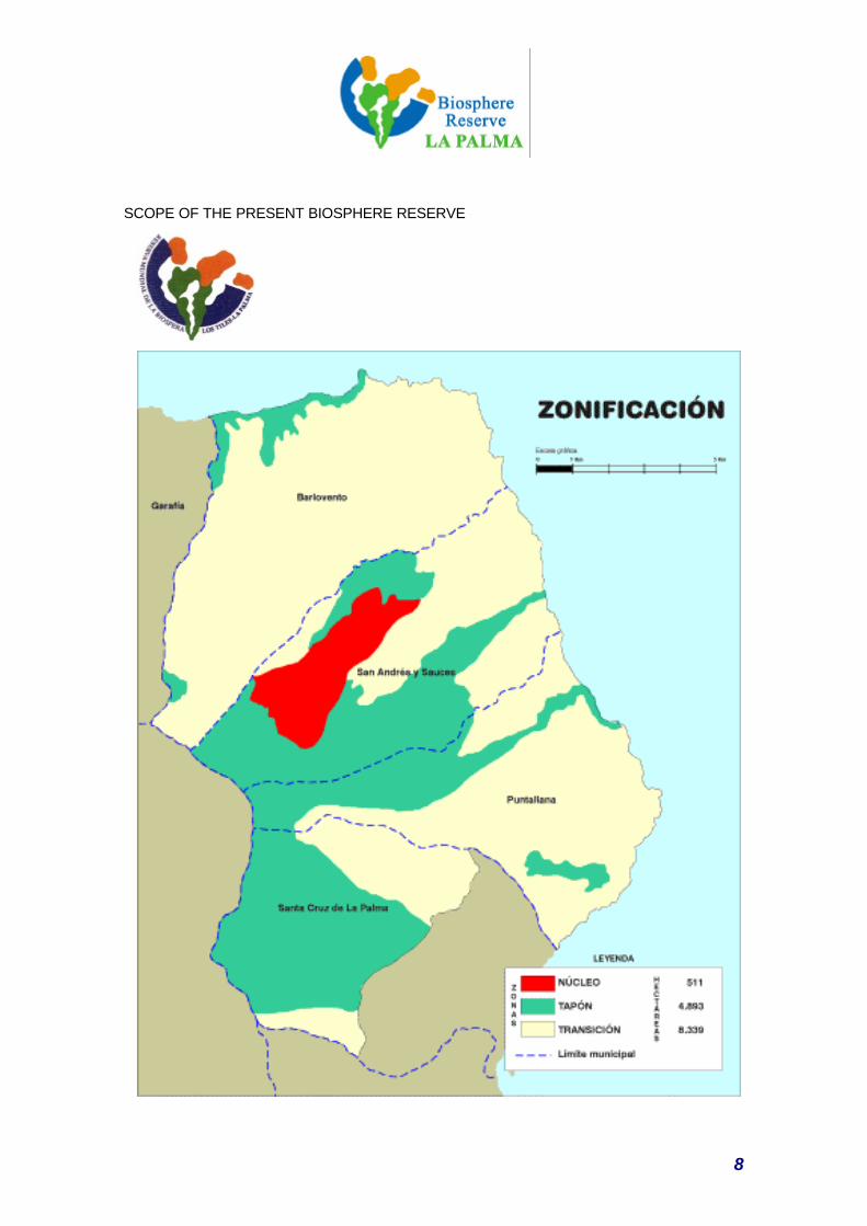
SCOPE OF THE PRESENT BIOSPHERE RESERVE
9
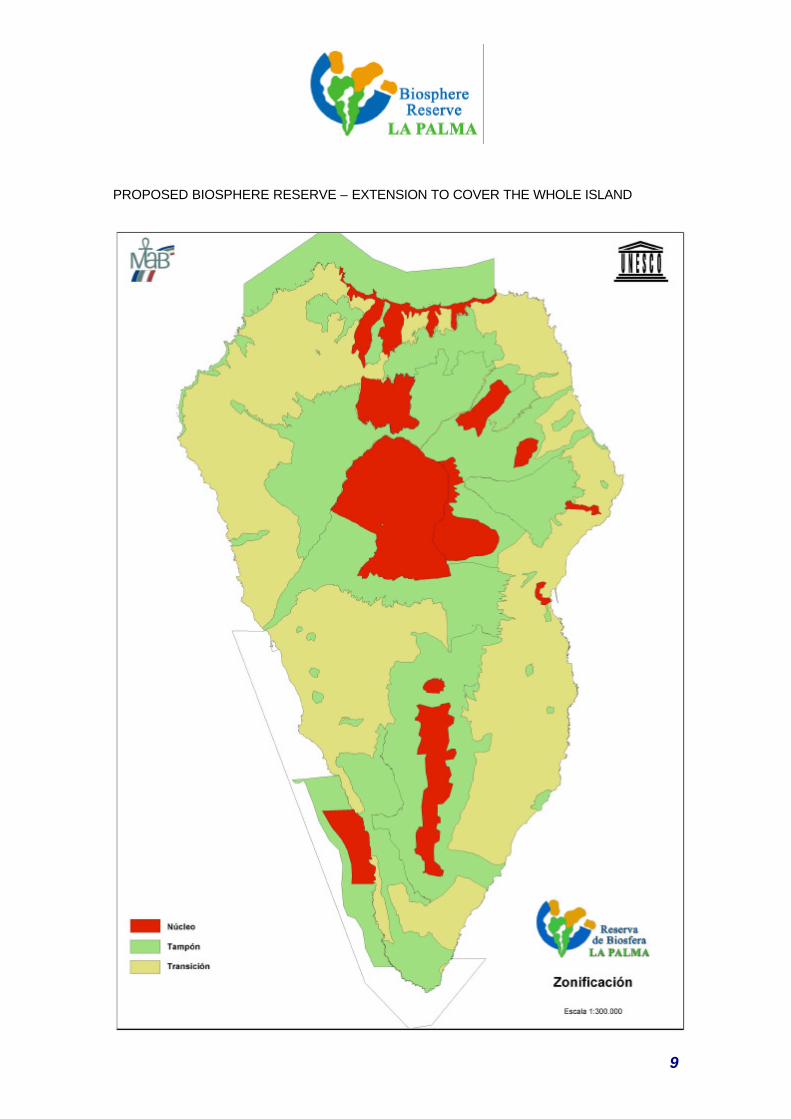
PROPOSED BIOSPHERE RESERVE – EXTENSION TO COVER THE WHOLE ISLAND
10
1. DENOMINATION
PROPOSED NAME
11
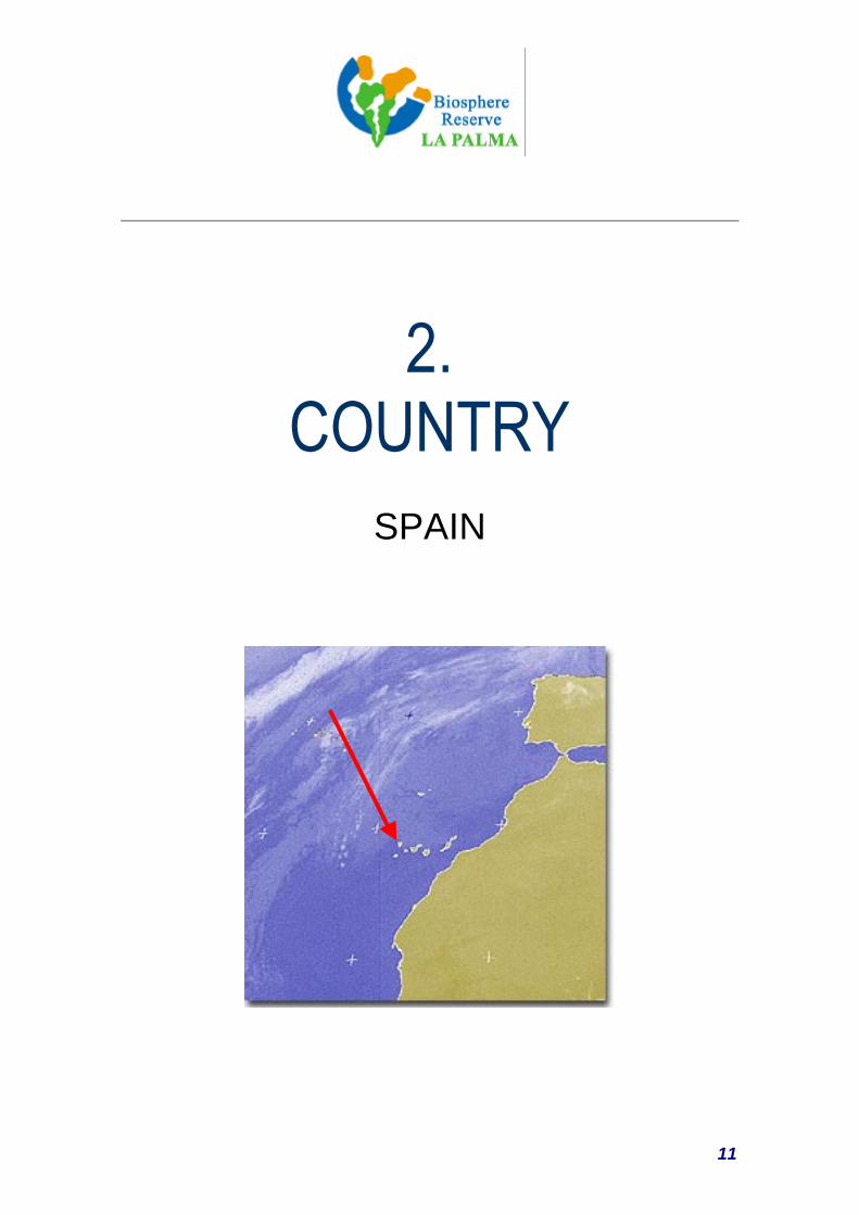
2. COUNTRY
SPAIN
12
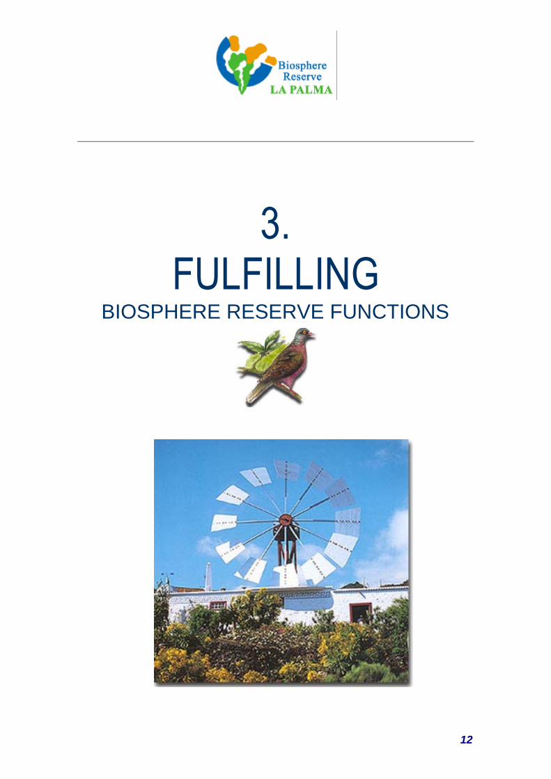
3. FULFILLING
BIOSPHERE RESERVE FUNCTIONS
13
3.1. CONSERVATION FUNCTION
It can be safely said that La Palma amply meets the necessary conditions for considering the
whole island a Biosphere Reserve, as it contains a high degree of biodiversity, with well
conserved ecosystems and habitats of great importance, with an extensive representation of the
most characteristic ecosystems of the Macaronesia region. There is a large number of endemic
plants among the vegetation, many of which are endemic to the island, while both the
invertebrate and vertebrate fauna are outstanding, without loosing sight of the great interest of
the marine communities.
The importance of this territory, therefore, is not merely local, it transcends the regional level,
as 229 of the species found in La Palma are exclusive to the island.
Declaring the whole island of La Palma a Biosphere Reserve signifies creating a territory in
which practically all the vegetation layers to be found in the Canary Islands are represented,
extending the presence of the ecosystems of the Archipelago already found in the Reserves of
Lanzarote and El Hierro. Including the Caldera de Taburiente National Park in the extension of
the Reserve means that one of the most natural areas of the Canary Islands will be included in
the Reserve, an area whose environmental and cultural values and its connections with the
Auritas, the pre-Hispanic settlers of the island, have made it emblematic.
What is more, the island of La Palma also holds a major cultural heritage. This heritage not
only encompasses a wealth of archaeological sites, including some of the best engravings to be
found in the Canary Islands like Cueva de Belmaco and La Zarza, as well as abundant remains
of burial mounds in the mountain peaks of the Caldera, it also represents the survival of a
cultural legacy based on a mixture of Afro-American and European currents, which have given
way to the peculiar idiosyncrasy of La Palma in the Canary Island context.
To a large extent, this explains why the island of La Palma has conserved so many of its
natural values, which, in turn, explains why 33% of the island has been declared Protected
Natural Space by the Canary Island Natural Spaces Act, Law 12/1884, of the 19th of December,
currently included in Legislative Decree 1/2000, of the 8th of May, which adopts the modified
14
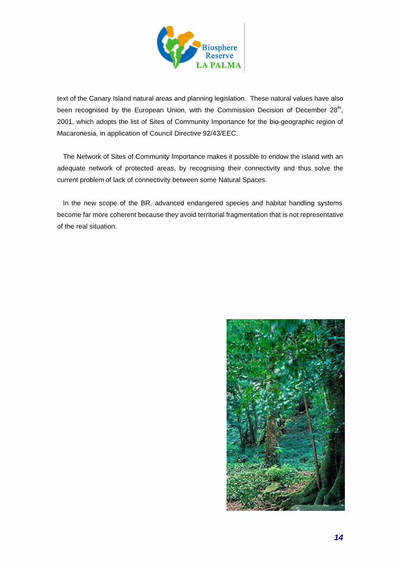
text of the Canary Island natural areas and planning legislation. These natural values have also
been recognised by the European Union, with the Commission Decision of December 28th,
2001, which adopts the list of Sites of Community Importance for the bio-geographic region of
Macaronesia, in application of Council Directive 92/43/EEC.
The Network of Sites of Community Importance makes it possible to endow the island with an
adequate network of protected areas, by recognising their connectivity and thus solve the
current problem of lack of connectivity between some Natural Spaces.
In the new scope of the BR, advanced endangered species and habitat handling systems
become far more coherent because they avoid territorial fragmentation that is not representative
of the real situation.
15
3.2. DEVELOPMENT FUNCTION
Based on the recommendations of the Agenda 21 of the United Nations Conference on
sustainable development of islands and Small Island States (Barbados 1994) and the guidelines
emerging from the European Conference on Sustainable Island Development (Minorca 1997)
and taking the Seville Strategy as a reference, La Palma has built an action model with practical
and palpable interventions in the fields and areas that determine the future of the island.
So, apart from a stringent and effective conservation policy for the biodiversity and the
representative landscape sites of this region that are to be found on the island, there are also
specific sustainable policies in key development sectors: water, energy, agriculture, livestock,
transport, tourism, fishing, communications and waste, essential aspects in all island regions,
for which suitable solutions must be found. In fact, for the Canary Islands, La Palma has always
been, and continues to be, a driving force of sustainability innovation in areas like rural
development, choosing new forms of environmental and rural habitat tourism, while the islands
were moving towards uncontrolled development. This is a responsible view of the use of land
and its resources that also included aspects of technological innovation in areas like telemetry
for sustainable development.
This is a pioneering attitude that can be seen in outstanding actions such as the fact that La
Palma has adopted the World’s first Protection of the Skies Act, or the fact that in 1996, La
Palma organised the first International Conference of Biosphere Reserve Islands with this basic
objective.
The main role that should be given to the Network of Biosphere Reserves, compared with the
other Protected Natural Areas, is precisely its innovation potential in implementing sustainable
development pilot and demonstration projects. The complete integration of the human factor in
Reserve management means we can go beyond conservation policies and management also
takes the social and economic environment into account as a priority component in the
objectives of the Reserve.
16
The large number of sustainable development related initiatives, programmes and projects,
includes some aspects that give the island of La Palma a special capacity for becoming a
benchmark for sustainable development, with special impact in island regions:
a) The island has a Sustainable Development Plan called the La Palma Strategic
Bases Document.
The process of this Sustainable Development Plan has been a real challenge to attain
general participation. For over a year, it has been widely discussed, sector by sector,
covering the full spectrum of the island’s civil society. The document was finally adopted by
all the municipal boroughs, social and economic partners and by all political powers.
The fundamental areas and aspects addressed by the document include the strategy of
sustainability in:
Re-adapting socially and regionally decisive productive systems: bananas and the
traditional agro-livestock complex.
Defining the development of responsible tourism and acceptable carrying capacity,
admitting innovation, diversification and the full environmental adaptation of the activity.
Accelerating R+D processes and the full incorporation of the Information Society to promote
sustainable development and value added services.
Favouring connectivity between different sectors and promoting innovation for
environmentally friendly production: new links with the following sectors: foothills, fish-
farming-fishing, organic agriculture and handicrafts.
Planning infrastructures that are in line with the reality of the island and the specificity of its
environment. Introduction of the culture of respectful design.
Consolidating the logistic support centres: Canary Island Astrophysics Institute
(technology), ZEC (investments), Development Agency and Business Logistics Centre
(entrepreneurship), “Excellency Plan” (strategic marketing), SIG La Palma (administrative
and regional management modernisation), CIAB-ICIA-Institute of Natural Products
(research) and Overseas Promotion Agency (promotional connectivity).
17
b) The Biosphere Reserve and municipal Agenda 21s.
One aspect considered innovative in the practise of the development function of
Biosphere Reserves is the articulation of its strategy with the implementation of Agenda 21s
at a local level, in each borough.
In the course of this year, all the boroughs of the island of La Palma have adopted the
Aalborg charter for sustainable municipalities, whilst also appointing the respective local
agents responsible for their development.
The present BR Consortium is developing the necessary assistance to enable
municipalities to adopt their local Action Plans by the end of the year, once they have
completed the pertinent environmental diagnosis and started the information and
participation process.
c) Sustainable Rural Development and the Leader + Programme.
As we can see by referring back to the UNESCO’s Seville agreements, a major part of the
strategy of island reserves coincides fully with the position of Programmes like Leader +. As
stated in the Commission’s Communication to Member States of April 14th, 2000, whereby
guidelines are set on the community rural development initiative (LEADER +), the purpose of
this initiative is to foster the application of original, high quality integral sustainable development
strategies aimed at:
• Revaluing the natural and cultural heritage,
• Improving the economic environment, in order to help create employment,
• Improving the organisational capacity of communities in favour of Sustainable Development.
In this sense, the La Palma Leader + Programme is considered the best model programme put
on the table in the Canary Islands in the Leader + evaluation, and one of the leading
sustainability and rural development benchmarks in Europe.
18
3.3. LOGISTIC FUNCTION
The logistic function of support for environmental demonstration, education and skill-building
and research and observation projects is covered in a structured manner in specific fields.
The present Los Tiles Biosphere Reserve has a Research Centre, equipped with a laboratory
to provide support for the scientists undertaking field work, especially in the area of the laurel
forest.
La Palma has an Environmental Education and Training Planning Document, the PLASIA,
which defines lines of action in matters of Environmental Education and Training.
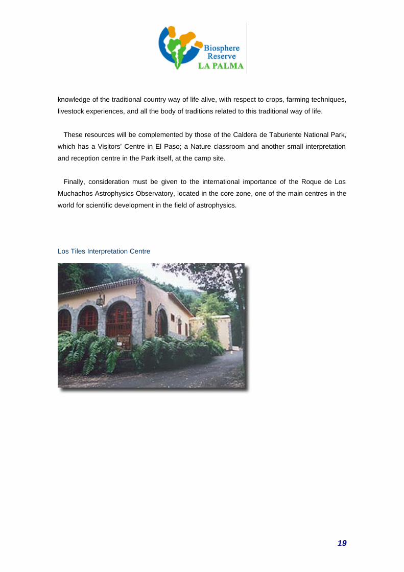
The Los Tiles Interpretation Centre has a permanent exhibition of the present Reserve,
including a multi-media hall and Environmental Interpretation resources for groups.
Furthermore, there are plans to use the Quinta Verde centre, in Santa Cruz de La Palma, as the
strategic facility for interpreting the Natura 2000 Network, with the support of a series of
environmental information points to be located in the remaining environmental amenities.
The Teneguía volcanoes, the cones of which have been proposed as the core zone of the
Reserve, also have an Interpretation Centre for the volcanic activity of the area, where the last
volcanic eruption in the Canary Islands took place in the 20th century.
The planned amenities also include two nature classrooms, one in the area of the Puntagorda
Wax Myrtle forest and the other on the slopes of Barlovento, preferably in Cubo de La Galga,
for interpreting in the Biosphere Reserve and as environmental workshop centres.
On the other hand, the La Palma Cabildo (Island Council) has started implementing the
project to create a Rural World Interpretation Centre, to maintain the enormous wealth of
19
knowledge of the traditional country way of life alive, with respect to crops, farming techniques,
livestock experiences, and all the body of traditions related to this traditional way of life.
These resources will be complemented by those of the Caldera de Taburiente National Park,
which has a Visitors’ Centre in El Paso; a Nature classroom and another small interpretation
and reception centre in the Park itself, at the camp site.
Finally, consideration must be given to the international importance of the Roque de Los
Muchachos Astrophysics Observatory, located in the core zone, one of the main centres in the
world for scientific development in the field of astrophysics.
Los Tiles Interpretation Centre
20
4. CRITERIA
FOR THE DESIGNATION
21
4.1. A MOSAIC OF REPRESENTATIVE ECOLOGICAL SYSTEMS
Extending the Los Tiles Biosphere Reserve to include the entire island of La Palma makes it
possible to reinforce the presence of island ecosystems that presently have a more limited
presence within the borders of the current Reserve.
On the island of La Palma, there is a mosaic of representative ecosystems of the
Macaronesia Region, such as the spurge scrub, the transitional thermophile forests, the
laurel forests and the more long-suffering tree heath and wax myrtle forest, the Canary
Island pine forests and the Alpine scrub dominated by broom plants.
By extending the boundaries of the reserve to cover the rest of the island, we can include the
most valuable ecological systems of the region, which are not fully represented in the present
area. It even makes it possible to include coastal and marine areas and habitats that play a
fundamental role in island territories.
These ecosystems have evolved with a varying degree of human intervention, first by the pre-
Hispanic aboriginal settlers who had a subsistence economy based on livestock, the gathering
of shellfish and primary agriculture, and then, with the arrival of European settlers, the hilly
regions were progressively brought under the plough, which led to the regression of the
thermophile forests of which only isolated relicts remain, and the laurel and wax myrtle forests,
as the best farming and grazing lands were in their potential range.
All over the island, there are also important manifestations of highly interesting cultural
landscapes sculpted by man coexisting with the natural habitats. Specialisation in banana
plantations for decades is the predominant note in many of these cultural landscapes. This has
led, first of all, to the creation of a surprising landscape that covers practically all of the lowland
areas of the island between Puntallana and Los Llanos de Aridane, and, secondly, it has
modified the territory, adapting it to the needs of this crop. The best example of this are the
terraces that have been built in areas of difficult terrain, where dry stone walls have been
erected, in order to create the small flats on which the bananas are grown.. This has led to
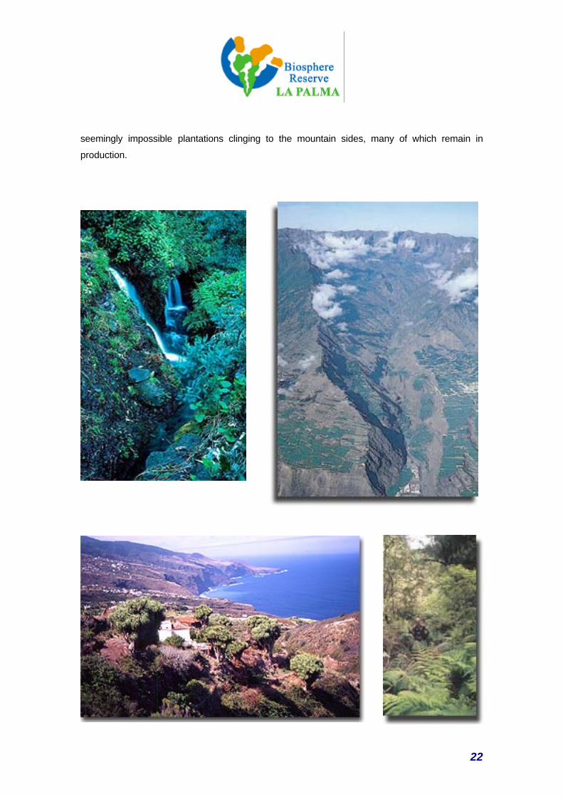
22
seemingly impossible plantations clinging to the mountain sides, many of which remain in
production.
23
4.2. IMPORTANCE FOR CONSERVING THE BIOLOGICAL DIVERSITY
According to BIOTA data, the Canary Island Government’s Terrestrial Biodiversity Data Base,
the island of La Palma has 4,885 species, 980 of which are endemic, giving a 20% rate of
endemic species. Furthermore, of the 980 endemic species described for La Palma, 229 are
exclusive to the island.
More specifically, the vegetation of La Palma is characterised by its diversity, an aspect that is
especially striking if we consider the small area in question. This feature of the vegetation is
related to the characteristics of the flora, the location of the island and, above all, to its
mountainous nature, which in combination with the climatic conditions, offers a wealth of
different kinds of vegetation, organised in different layers. That is why La Palma shelters a
representation of all the different layers of vegetation to be found in the Canary Islands, except
for the high Alpine vegetation that is only found around the summit of Mt. Teide, on the island of
Tenerife.
The island has one of the best examples of humid mountain Laurel Forests that covers a large
area because of the special configuration of the island terrain.
Apart from the high proportion of endemic species that can also be found among the fauna,
where animal species endemic to La Palma and the Canary Islands have been recorded that
belong to sub-genera that are exclusive to Macaronesia (this is the case of the blue tits -Parus
caeruleus-, lizards and a large number of invertebrates), the importance of the marine
communities should also be highlighted, with their complex and highly divers bio-geographic
spectrum.
With regard to species of economic importance, La Palma has conserved a large amount of
genetic wealth in comparison with other islands, which can be seen in some varieties of vine
and potato, or the black pig.
24
4.3. SUSTAINABLE DEVELOPMENT the chance to test and demonstrate sustainable
development methods on a regional scale
Apart from fulfilling the objectives of conserving biodiversity and maintaining important natural
habitats more satisfactorily on an island scale that is far more coherent with the management
systems and the legal scope of these natural areas, extending the reserve also meets the need
for consolidating a coherent sustainable development strategy on the island, based on the
experience built up within the present reserve.
In fact, the scope of many of the new sustainable island development initiatives that have
emerged goes far beyond the limits of the present reserve. These new lines of action have won
La Palma a place as a pilot zone for promoting sustainable development in the Macaronesia
Region, and in a network of other islands with which close co-operation is maintained.
In short, it gives expression to the initiatives in course that justify the need to extend the
reserve to guarantee that the innovation measures and new sustainability management
methods will become efficient bench marks at both a local and a regional level:
1.
The existence of an island-wide Sustainable Development Plan with major methodological
innovations and genuinely wide involvement of both the public and private sectors, drawn up
after an extensive process of debate.
2.
The decision to include in the Biosphere Reserve strategy the process, already in course, of
launching Agenda 21s in every municipality on the island, which is a completely innovative
complement in all island territories (declared BRs or not).
3.
The existence of an advanced Public Use Plan for natural spaces, whose initial achievements
have already made it a regional bench mark that cannot be ignored.
25
4.
The integral approach to using telemetric resources for integrating management and information
systems, creating a model for integrating the island in the Information Society for the benefit of
sustainable development, in co-operation with other islands, and
5.
The strategy launched within the framework of the Leader + Programme, aimed at revaluing
natural and cultural resources in the rural world, which has already established itself as a
regional and Europe-wide bench mark.
6.
The possibility of developing new forms of responsible tourism, in the broadest sense of the
term, based on the wealth of experience accumulated in the field of rural tourism. The La Palma
Reserve opens the doors to new, innovative forms of tourism in this area.
7.
Promoting the high value and environmentally friendly products, based on revaluing traditional
farming and livestock systems and bringing them in line with the new demands of the market.
8.
The projects, programmes and initiatives concerned with sectoral policies of sustainable
development:
Alternative energies, waste management, Hydrological Plan, alternative transport, Network of
Trails, conservation actions on the coast.
9.
Taking on board sustainable development strategies in the fishing industry and in the marine
environment, with the creation of a Marine Fishing Reserve, at the request of fishermen and
other social groups.
26
4.4. SUFFICIENT SIZE to fulfil its functions as a BR
The zoning established covers, both in surface area and in diversity of situations, an
appropriately sized space for comfortably fulfilling the functions established for Biosphere
Reserves, in concordance with the guidelines that have come out of the Seville Strategy and
later recommendations.
The scale of the island added to the complexity and singularity of its habitats, resources,
activities and settlements, offers us a complex mosaic that is large enough to address the major
conservation and development challenges in a complex island system, characteristic of a
medium-sized island.
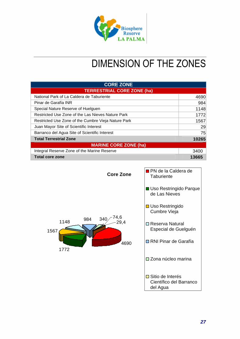
The core zone, with over 10,000 hectares, contains representations of the main habitats and
sites of singular ecological importance on the island, accounting for almost 14% of the island’s
surface area.
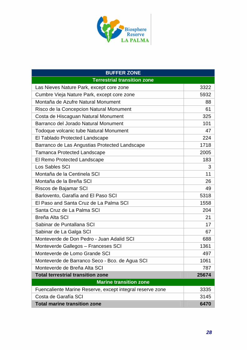
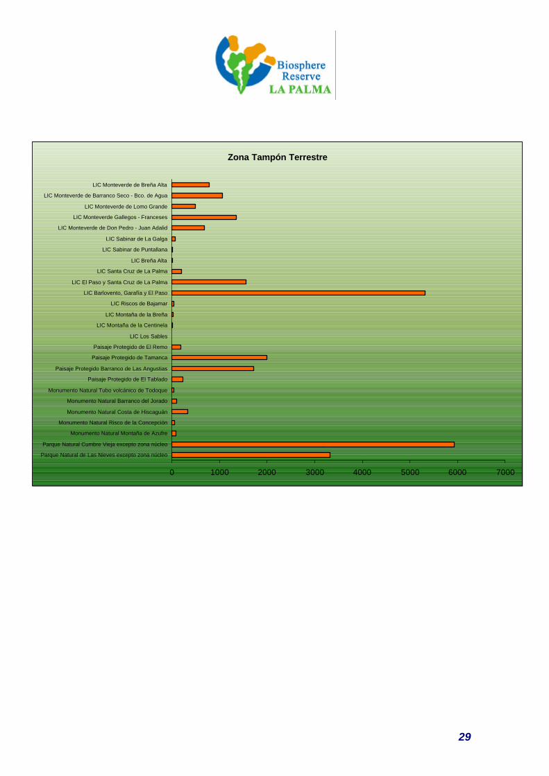
The buffer zone covers 36% of the island’s area, and is essential as a guarantee area and an
interface with productive activities as a whole. This is an extensive zone that, together with the
core zone, complements and guarantees the input of vital resources like water, the production
of natural and rural landscape, as a foundation for developing responsible tourism, and which is
the home of traditional practises that are a fundamental link in maintaining a creative and
productive relationship with the natural spaces.
50% of the territory, with a population of over 80,000 inhabitants, makes up the framework for
developing a strategy of sustainability. This is an area in which one can find a rich rural
environment in the process of revaluation, including new perspectives for managing marine
resources, and which holds an exceptional historic and cultural heritage, with fine
manifestations like the old quarter of Santa Cruz de La Palma.
In short, it is a space that is large and complex enough to put a genuinely island-wide strategy
of sustainable development into practise.
27
DIMENSION OF THE ZONES
CORE ZONE TERRESTRIAL CORE ZONE (ha)
National Park of La Caldera de Taburiente 4690 Pinar de Garafía INR 984 Special Nature Reserve of Huelguen 1148 Restricted Use Zone of the Las Nieves Nature Park 1772 Restricted Use Zone of the Cumbre Vieja Nature Park 1567 Juan Mayor Site of Scientific Interest 29 Barranco del Agua Site of Scientific Interest 75 Total Terrestrial Zone 10265
MARINE CORE ZONE (ha) Integral Reserve Zone of the Marine Reserve 3400 Total core zone 13665
Core Zone
46901772
1567
1148 29,4984 74,6340
PN de la Caldera deTaburiente
Uso Restringido Parquede Las Nieves
Uso RestringidoCumbre Vieja
Reserva NaturalEspecial de Guelguén
RNI Pinar de Garafía
Zona núcleo marina
Sitio de InterésCientífico del Barrancodel Agua
28
BUFFER ZONE
Terrestrial transition zone Las Nieves Nature Park, except core zone 3322 Cumbre Vieja Nature Park, except core zone 5932 Montaña de Azufre Natural Monument 88 Risco de la Concepcion Natural Monument 61 Costa de Hiscaguan Natural Monument 325 Barranco del Jorado Natural Monument 101 Todoque volcanic tube Natural Monument 47 El Tablado Protected Landscape 224 Barranco de Las Angustias Protected Landscape 1718 Tamanca Protected Landscape 2005 El Remo Protected Landscape 183 Los Sables SCI 3 Montaña de la Centinela SCI 11 Montaña de la Breña SCI 26 Riscos de Bajamar SCI 49 Barlovento, Garafía and El Paso SCI 5318 El Paso and Santa Cruz de La Palma SCI 1558 Santa Cruz de La Palma SCI 204 Breña Alta SCI 21 Sabinar de Puntallana SCI 17 Sabinar de La Galga SCI 67 Monteverde de Don Pedro - Juan Adalid SCI 688 Monteverde Gallegos – Franceses SCI 1361 Monteverde de Lomo Grande SCI 497 Monteverde de Barranco Seco - Bco. de Agua SCI 1061 Monteverde de Breña Alta SCI 787 Total terrestrial transition zone 25674
Marine transition zone Fuencaliente Marine Reserve, except integral reserve zone 3335 Costa de Garafía SCI 3145 Total marine transition zone 6470
29
Zona Tampón Terrestre
0 1000 2000 3000 4000 5000 6000 7000
Parque Natural de Las Nieves excepto zona núcleo
Parque Natural Cumbre Vieja excepto zona núcleo
Monumento Natural Montaña de Azufre
Monumento Natural Risco de la Concepción
Monumento Natural Costa de Hiscaguán
Monumento Natural Barranco del Jorado
Monumento Natural Tubo volcánico de Todoque
Paisaje Protegido de El Tablado
Paisaje Protegido Barranco de Las Angustias
Paisaje Protegido de Tamanca
Paisaje Protegido de El Remo
LIC Los Sables
LIC Montaña de la Centinela
LIC Montaña de la Breña
LIC Riscos de Bajamar
LIC Barlovento, Garafía y El Paso
LIC El Paso y Santa Cruz de La Palma
LIC Santa Cruz de La Palma
LIC Breña Alta
LIC Sabinar de Puntallana
LIC Sabinar de La Galga
LIC Monteverde de Don Pedro - Juan Adalid
LIC Monteverde Gallegos - Franceses
LIC Monteverde de Lomo Grande
LIC Monteverde de Barranco Seco - Bco. de Agua
LIC Monteverde de Breña Alta
30
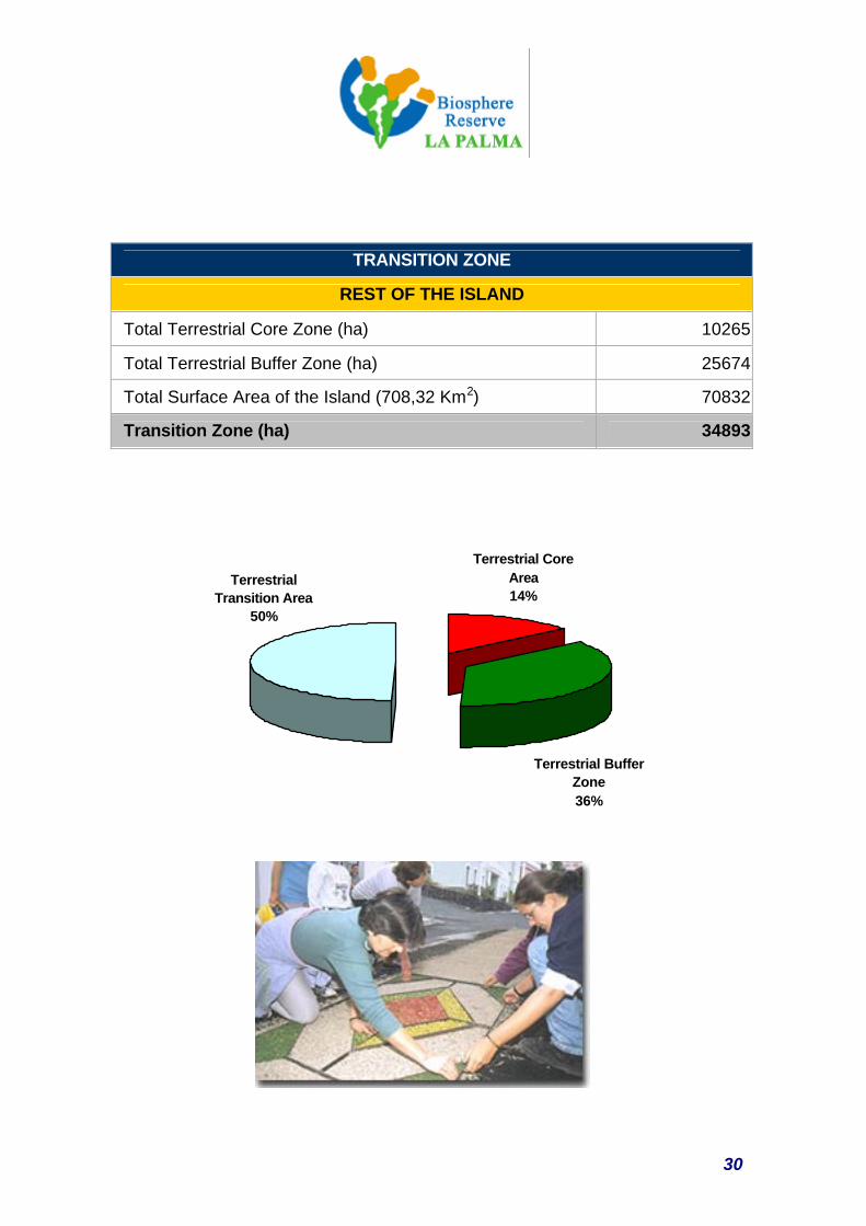
TRANSITION ZONE
REST OF THE ISLAND
Total Terrestrial Core Zone (ha) 10265
Total Terrestrial Buffer Zone (ha) 25674
Total Surface Area of the Island (708,32 Km2) 70832
Transition Zone (ha) 34893
Terrestrial Transition Area
50%
Terrestrial Core Area14%
Terrestrial Buffer Zone36%
31
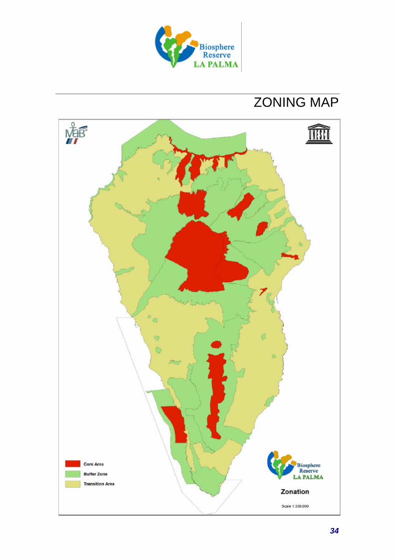
4.5. APPROPRIATE ZONING RATIONALE AND GENERAL CRITERIA
The proposed zoning for the reserve has been carried out based on the general criterion that
all the selected zones can perfectly cover the functions of conservation, development and
logistics entrusted to the reserve, giving consideration to the functionality of the spaces, their
natural and heritage values and, of course, the necessary degree of protection to guarantee the
success of the designated functions.
Each proposed space is legally sustained with all the guarantees of protection, conservation
and functionality in line with the objectives that are set for a Biosphere Reserve. Its status is
also in line with its level of uses.
In the design and processing of zoning for the island of La Palma, the following considerations
have been taken into account:
a) The existence of La Caldera de Taburiente National Park, declared as such in 1954. The
first National Park to be approved after almost two decades of decadence in nature
conservation policy in Spain. This was one of the first steps to re-activating the present
Network of National Parks.
b) The existence of a complete Network of National Parks consolidated under the Canary
Island Natural Spaces Act (Law 12/1994), which, for the case of La Palma, includes five
degrees of protection for the purpose of developing an integral management model
capable of making Canary Island diversity and the protection of cultural and aesthetic
values compatible with a sustainable use of scarce and valuable island resources.
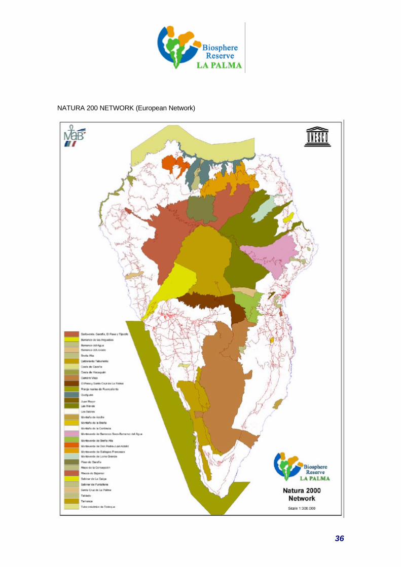
c) The consolidation of a series of sites of community interest, included in the Natura 2000
Network, that overlap and complement the previous protected areas, taking on board a
dynamic vision of the territory in the connection of natural habitats and habitats of species,
including areas like the Special Protection Areas for Birds.
d) The existence of a Natural Resources Planning Strategy that provides a framework for all
different protection mechanisms in the island’s regional planning system. The Canary
Islands Natural Spaces Act (Law 12/1994 of December 19), defines the island as a priority
32
territorial area in the Natural Resource Planning Strategies (PORNs from their initials in
Spanish) and they are included in the Island Planning Strategies (PIOs), so a single
planning instrument is used for the integral planning of each island.
e) The existence of a Marine Fishing Reserve, with the corresponding zoning system.
Apart from these aspects related to the terrestrial and marine environment, consideration must
be given to the fact that La Palma is the seed of the first known legislation in the world
concerning Protection of the Skies; the Protection of the Skies Act appeared because there was
a need to prevent light pollution from affecting the Roque de Los Muchachos Astrophysics
Centre, sited in the proposed core zone, and thus allowing it function properly.
Starting with these foundations and recognising the different values and functions of each
space, zoning is established depending on the category of each space and the following criteria:
CORE ZONE:
As the most valuable spaces for conservation should be included in the core zone, it was
decided to select those Natural Spaces that already enjoy the maximum level of protection in
Canary Island, national and international legislation, and which also contain a regional scale
representative sample of the main habitats; Parks, Reserves and Sites of Scientific Interest,
plus the exclusion zone of the La Palma Marine Reserve, included in the Fuencaliente Marine
Strip SCI, which forms part of the Natura 2000 Network.
Emphasis must also be given to the fact that the cultural dimension is also contemplated in this
form of cataloguing natural spaces, by including archaeological sites of exceptional importance.
• La Caldera de Taburiente National Park
• Huelguen and El Pinar de Garafía Integral Nature Reserves.
• Barranco del Agua and Juan Mayor Sites of Scientific Interest. The Site of the
Fuencaliente salt flats has not been included because of its obvious predominance of
human intervention.
• Restricted Use Zones of the Cumbre Vieja and Las Nieves Nature Parks.
• Integral Reserve Zone of the La Palma Marine Reserve.
BUFFER ZONE
This is an area of high natural and scenic value where many conservationist activities are
presently carried out alongside activities that are compatible with ecological practises, like
environmental education, recreation, ecological tourism, walking and applied and basic
33
research. An enormous effort has been made in recent years, to make some traditional farming
and livestock activities compatible with conserving valuable communities and ecosystems. Thus
the first fruits of a policy of redefining the model for integrating traditional uses in the
environment are now starting to appear. It also includes high value areas of human intervention,
like agricultural cultural landscapes, elements of integrated rural architecture and, especially, an
archaeological heritage of exceptional importance.
It also includes all the other areas belonging to the Canary Island Network of Natural Spaces
and the remaining 17 spaces of the island that have been proposed for inclusion in the Natura
2000 Network, which, furthermore, includes important marine-coastal environments.
TRANSITION ZONE
The Rest of the Island
The transition zone comes under the Island Planning Strategy that contemplates a harmonious
regional development of the island. One outstanding aspect is the presence of an exceptional
rural heritage and singular agricultural landscapes.
This is the space in which practically all the productive activities of the reserve take place, with
the exception of nature tourism.
In particular, it is the specific scope for implementing the La Palma Sustainable Development
Plan and the Rural Development Plan generated within the contexts of the Leader +
Programme. In this framework, the development of Agenda 21s in each municipality will make it
possible to fit the zone’s activities in with the presence of the core and transition zones more
coherently.
34
ZONING MAP
35
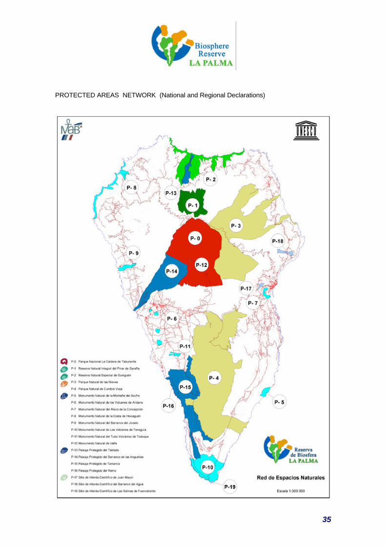
PROTECTED AREAS NETWORK (National and Regional Declarations)
36
NATURA 200 NETWORK (European Network)