Embed Size (px)
Citation preview
UNITED STATES DEPARTMENT OF THE INTERIOR
GEOLOGICAL SURVEY
Volcanic Hazardswith Regard to Siting Nuclear-Power Plants
in the Pacific Northwest
by
Richard P. Hoblitt 1 - 2 , C. Dan Miller 1 , and William E. Scott 1
Open-File Report 87-297
This report is preliminary and has not been reviewed for conformity with U.S. Geological Survey editorial standards and stratigraphic nomenclature.
U.S. Geological Survey Cascades Volcano Observatory 5400 MacArthur Blvd. Vancouver, WA 98661
Authors listed alphabetically
1987
CONTENTS
Chapter 1
Chapter 2
Chapter 3
Chapter 4
Page
Executive Summary........................... 5
Introduction................................ 72.1 Background............................. 72.2 Purpose and scope...................... 92.3 Acknowledgments ........................ 11
Types and effects of potentially hazardousvolcanic events............................ 123.1 Introduction........................... 123.2 Flowage phenomena...................... 12
3.2.1 Debris avalanches............ 123.2.2 Pyroclastic flows............ 133.2.3 Pyroclastic surges........... 143.2.4 Volcanic blasts.............. 153.2.5 Lava flows................... 163.2.6 Lava domes................... 163.2.7 Lahars....................... 173.2.8 Floods. ...................... 18
3.3 Tephra................................. 193.4 Emission of volcanic gases............. 233.5 Other hazardous events associated
with volcanic activity. ............... 233.5.1 Volcanic seismicity.......... 243.5.2 Amospheric shock waves
induced by eruptions. ....... 24
Eruptive history and volcanic-hazardsassessment for Cascade volcanoes........... 274.1 Introduction........................... 274.2 Mount Baker ............................ 28
4.2.1 Eruptive history............. 284.2.2 Volcanic-hazards assessment.. 32
4.3 Glacier Peak........................... 334.3.1 Eruptive history. ............ 334.3.2 Volcanic-hazards assessment.. 36
4.4 Mount Rainier .......................... 384.4.1 Eruptive history............. 384.4.2 Volcanic-hazards assessment.. 41
4.5 Mount Adams ............................ 424.5.1 Eruptive history............. 424.5.2 Volcanic-hazards assessment.. 42
4.6 Mount St. Helens ....................... 464.6.1 Eruptive history............. 464.6.2 Volcanic-hazards assessment.. 50
Chapter 5
Chapter 6
4.7 Mount Hood............................. 524.7.1 Eruptive history............. 524.7.2 Volcanic-hazards assessment.. 57
4.8 Mount Jefferson........................ 574.8.1 Eruptive history............. 574.8.2 Volcanic-hazards assessment.. 59
4.9 Three Sisters.......................... 614.9.1 Eruptive history. ............ 614.9.2 Volcanic-hazards assessment.. 65
4.10 Newberry volcano ....................... 664.10.1 Eruptive history............. 664.10.2 Volcanic-hazards assessment.. 66
4.11 Crater Lake (Mount Mazama)............. 694.11.1 Eruptive history. ............ 694.11.2 Volcanic-hazards assessment.. 71
4.12 Medicine Lake volcano.................. 734.12.1 Eruptive history. ............ 734.12.2 Volcanic-hazards assessment.. 77
4.13 Mount Shasta........................... 774.13.1 Eruptive history............. 774.13.2 Volcanic-hazards assessment.. 83
4.14 Lassen volcanic center ................. 844.14.1 Eruptive history. ............ 844.14.2 Volcanic-hazards assessment.. 86
4.15 Basaltic volcanoes and lava fields ofthe Cascade Range ..................... 91
4.15.1 Distribution and eruptivecharacter................... 91
4.15.2 Volcanic-hazards assessment.. 94
Volcanic-hazard zones for eruptions of Cascade Range volcanoes .................... 96
5.1 Introduction........................... 965.2 Proximal-hazard zones .................. 975.3 Distal hazard zones for lahars
and floods............................ 1065.4 Tephra-hazard zones .................... 1075.5 Hazard zones for eruptions of
basaltic volcanoes and volcanicfields of the Cascade Range........... 113
General guidelines for evaluating volcanic hazards at proposed sites for nuclear power plants in the Pacific Northwest...... 1156.1 Introduction ........................... 1156.2 Evaluation criteria used in previous
safety-analysis reports for nuclear power plant sites..................... 118
6.3 Guidelines for evaluation of sites ineach hazard zone ...................... us
6.3.1 Proximal-hazard zones........ 118
6.3.2 Distal lahar- and flood- hazard zones................ 122
6.3.3 Hazard zones for basaltic volcanoes and volcanic fields...................... 125
6.3.4 Tephra-hazard zones.......... 127
References................................................. 130Appendix A. Tables summarizing recent activity of
Cascade volcanoes Appendix B. Glossary
CHAPTER 1
EXECUTIVE SUMMARY
This report identifies volcanoes in the Cascade Range of Washington, Oregon, and California that constitute a potential threat to people and works of man, and assesses the hazards that could result from future eruptions of these volcanoes. The assessments are based on the premise that past eruptive histories of volcanoes provide the best basis for judging the most likely kinds, frequencies, and magnitudes of future volcanic events. These assessments can be used to evaluate volcanic hazards at sites of proposed nuclear power plants, as well as for more general purposes of long-range land-use planning. The principal conclusions of the report include the following.
1. Potentially hazardous volcanic events that can occur at Cascade Range volcanoes consist chiefly of flowage phenomena (lava flows, pyroclastic flows and surges, debris avalanches, lateral blasts, and lahars and floods), fall of tephra (volcanic ash), emission of volcanic gases which can be carried by the wind, and eruption-induced atmospheric shock waves. Other phenomena that are hazardous close to a volcano include volcanic earthquakes and ground fractures. Chapter 3 describes these phenomena and their effects on people and works of man. Many flowage phenomena are dangerous because they have volumes and densities great enough to damage or destroy structures; these properties as well as heat can also injure or kill people.
Most flowage events extend no more than a few tens of kilometers from a volcano, although the largest known debris avalanches and pyroclastic flows from Cascade volcanoes have reached at least 60 km down valleys. Lahars and related floods commonly extend to distances greater than 50 km, and some have exceeded 100 km. The probability is very low that tephra from a Cascade Range volcano would be more than 1 m thick at a distance of more than 50 km, but tephra more than 1 cm thick can be deposited hundreds of kilometers downwind. Tephra can damage structures and machinery, but seldom causes total destruction or threatens lives. Volcanic gases rarely are a danger to people beyond a distance of 15 km from their source vent.
2. Discussions in Chapter 4 of the recent eruptive history of each of the 13 major volcanoes of the Cascade Range, as well as fields of basaltic volcanoes, provide a basis for assessing the character and annual probability of future eruptions as well as their anticipated areal extent. In addition, hazardous events of a type or magnitude unprecedented at each volcanic center are evaluated by analogy with such events at other, similar volcanoes. The compilations of eruptive histories show wide ranges in frequency of events such as large-volume flowage deposits and explosive eruption of voluminous tephra, from one volcano to another. Mounts Baker and Rainier, for example, have given rise
to relatively numerous and extensive lahars; Mount St. Helens has on 4 occasions erupted more than 0.1 km3 of tephra within just the last 500 years, whereas Mounts Adams, Hood, Jefferson, and several other volcanoes have erupted none of that volume for at least 15,000 years.
3. Volcanic-hazard zonation maps of the northwestern United States, which accompany the report and are described in Chapter 5, identify areas that could be affected by various kinds and scales of volcanic events. Plate 1 shows proximal-hazard zones, which are areas within 50 km of each volcano that could be affected by many kinds of flowage phenomena as well as thick tephra fall and atmospheric shock waves. This distance encompasses the most probable extents of almost all kinds of volcanic events except lahars, floods, and tephra fall. Plate 1 also shows distal lahar-and flood-hazard zones that extend beyond 50 km along valleys
heading on snow-covered volcanoes. The same plate outlines zones that could be affected by future eruptions of basaltic volcanoes; hazards in these zones include lava flows, tephra falls, pyroclastic surges, and fissuring and faulting of the ground. Plates 2, 3, and 4 show the calculated annual probabilities of areas being affected by 1, 10, and 100 centimeters of tephra during future eruptions of the 13 major Cascade volcanoes.
4. Guidelines are suggested for the evaluation of volcanic hazards at proposed sites of nuclear power plants in the northwestern United States, both within and beyond proximal hazard zones. These evaluations should include a comprehensive knowledge of the eruptive histories of volcanoes in the region around the site, an evaluation of the effects of past eruptions at the site, an assessment of the probable types, magnitudes and frequencies of future eruptions in the region and their anticipated impacts on the site, identification of the maximum credible volcanic events that could affect the site, and evaluation of ways to mitigate the effects of future eruptions at the site.
CHAPTER 2
INTRODUCTION
2.1 Background
Electrical generating plants that utilize fossil fuels have traditionally been located close to their market areas; their sites have depended primarily upon the availability of fuel and water supplies. With the development of nuclear power, however, it became extremely important that the power plants be sited in areas that are relatively free of geologic hazards in order to avoid the consequences of damaging a nuclear reactor (Morris, 1979). Thus, the construction of such facilities requires an especially careful evaluation of geologic hazards (Morris, 1979; Adair, 1979; Tabor, 1986).
Guidelines for evaluations of geologic hazards at nuclear- power plant sites were issued in 1971 by the Atomic Energy Commission in Appendix A to 10 CFR Part 100, "Seismic and Geologic Siting Criteria for Nuclear Power Plants" (Federal Register [36 FR 228]). This was followed in 1972 by the Atomic Energy Commission's release of "Standard Format and Content of Safety Analysis Reports for Nuclear Power Plants" (see Regulatory Guide 1.70, 1975, for updated version). In 1973, an amended version of Appendix A to 10 CFR 100 was published in the Federal Register (38 FR 218). Still later versions of these guidelines can be found in the Code of Federal Regulations (1978). Utility companies involved in site investigations for nuclear power plants used these guidelines to prepare preliminary and final safety analysis reports, which were reviewed under the Standard Review Plan issued in 1975 by the U.S. Nuclear Regulatory Commission (NUREG-75-087).
Among the geologic hazards that must be evaluated in the siting of nuclear power plants are those associated with volcanic eruptions (Code of Federal Regulations, 1978; Adair, 1979). The Cascade Range of Washington, Oregon, and northern California (Fig. 2-1) has been an area of recurrent volcanism for tens of millions of years (e.g., McBirney and White, 1982) and volcanic activity continues at present. The frequency of eruptive activity during the past 1 million years (Chapter 4; Appendix A) indicates that the Cascade Range is an active continental-margin volcanic arc. Eruptions in the Cascades during the past 12,000 yr have occurred at an average rate of more than one per century; at least five eruptions have occurred during historic time (the last 150 years) (Crandell and Mullineaux, 1975) in addition to the well-documented 1980-1986 eruptions of Mount St. Helens (Appendix A; Lipman and Mullineaux, 1981). Future eruptions of Cascade Range volcanoes can have damaging effects on nuclear power plants as well as other facilities. Therefore, a careful evaluation of volcanic hazards is an important component of siting considerations for future nuclear power plants in the vicinity of the Cascade Range.
12 s:
Mount Baker
Glacier Peak
Washington
Mount Rainier
Mount Adams
Lassen Volcanic Center^
120*
Mount Garibaldi British Columbia
Canada "U.S." I
' .^Mourtt Jefferson.'.' /.'.vui .AThree Sisters Ortgon
' ./(ANeWberry Volcano
Volcano
Ntvada
100 200
km
50
45'
40°
Figure 2-1. Location map showing the 13 major Cascade volcanic centers discussed in this report and the extent of late Pliocene and Quaternary (past 4 million years) volcanic rocks. Figure modified from Muffler and others (1982).
We identify 13 volcanic centers in the Cascade Range (Fig. 2- 1) that, in our judgment, could erupt in the near future (the next few centuries). The selection of these volcanoes is analogous to the concept of "capable faults" (Code of Federal Regulations, 1978), which was developed for use in site studies for nuclear- power plants. Typically, these centers are marked by one or more large composite volcanoes that have been recurrently active for tens to hundreds of thousands of years. Another shared characteristic is that the time elapsed since their last eruption is short compared with their life span. For example, at Mount Jefferson, the least active of the centers during the past 15,000 yr, the current repose interval is probably on the order of 10 percent of the volcano's life span, whereas at Mount Rainier it is less than 1 percent. Current repose intervals of centers in the Cascade Range that we exclude are typically 50 percent or more of the life span of the center. For example, the Goat Rocks volcano between Mount Adams and Mount Rainier was active from about 3 million yr ago to a little less than 1 million yr ago (Clayton, 1983) .
Volcanoes of basalt or basaltic andesite comprise a second category of volcanoes treated in this report. A few thousand such volcanoes have erupted throughout much of the Cascade Range between Mount Rainier and Lassen Peak during the past several million years (Luedke and others, 1983; Smith and Luedke, 1984). Each volcano was active for a relatively short time period, but, by outlining the distribution of those less than 1 million years old, we define a zone that, in our judgement, could be affected by eruptions of these or new volcanoes.
2.2 Purpose and limitations of this report
The purpose of this report is to evaluate potential volcanic hazards in the northwestern United States from future eruptions of Cascade Range volcanoes, in order to assess such hazards at possible sites for nuclear power plants. As the region covered in this report is very large, the report cannot provide a detailed assessment of the volcanic hazards at specific sites. However, the rationale, methods, and results described and used here can provide a basis for a preliminary assessment of hazards at a site, and can help to guide additional detailed investigations. A further purpose of the report is to provide some general guidelines for assessing volcanic hazards in a form that could be useful for developing a more detailed regulatory guide than is now available.
The eruptive history of each volcano is the primary basis for our assessment of future volcano behavior and hazards. Using both published and unpublished data, we have constructed a composite record at each volcano of historical and prehistorical volcanic events (Appendix A) for various time periods that seem adequate to characterize the range of past activity. The composite histories are undoubtedly incomplete because of the certainty that the products of some eruptions were removed by erosion, buried by the
deposits of later events, or have not been recognized.In estimating the probability of events, we assume a Poisson
distribution (Wickman, 1965), because our data are too limited to justify other models. Therefore,
Probability = 1-e /m
where t is the future time period to which the probability applies, and m is the mean recurrence interval (Dibble and others, 1985). In this report, annual probabilities calculated from the above equation are effectively the same as the inverse of the recurrence interval, i.e., the mean frequency (ratio of the number of events to the number of years in which they occurred) .
In assessing certain types of hazards at some volcanoes, we have considered well-documented historical events at other similar volcanoes, particularly in order to illustrate the largest events that are expectable.
Although this report discusses the possible size range of various volcanic events, their probabilities, and their effects, it does not recommend levels of risk that should be accepted or the probabilities of eruptions and specific kinds of volcanic events that should be acceptable for siting decisions. Decisions concerning risk acceptance will be based on many factors not considered in this report, such as state-of-the-art engineering techniques, volcano monitoring and warning systems, availability of mitigative measures to reduce impact of volcanic events, cost- benefit assessments, and distribution and size of populations at risk.
This report does not discuss the bearing of future volcanic eruptions on selection of sites for nuclear waste repositories in the northwestern United States. This topic has been the subject of recent and ongoing analysis (e.g., Crowe, 1980, 1986).
This report consists of six chapters, the first two of which are the executive summary and the introduction. Chapter 3 discusses types of potentially hazardous volcanic events and their effects on the surrounding environment. Chapter 4 discusses the eruptive history and presents a volcanic-hazard assessment for each of the 13 major volcanic centers and for basaltic volcanoes and volcanic fields of the Cascade Range. Chapter 5 describes volcanic-hazard zones in the northwestern United States, which are illustrated on accompanying maps at a scale of 1:2,000,000. Four categories of hazard zones are defined: (1) proximal-hazard zones within a 50-km radius of major vents; (2) distal lahar- and flood- hazard zones along some valleys beyond a proximal-hazard zone; (3) tephra-hazard zones; and (4) hazard zones for basaltic volcanoes and volcanic fields. Chapter 6 recommends some guidelines for evaluating volcanic hazards at proposed sites for nuclear power plants .
10
2.3 Acknowledgements
This report was funded by the U.S. Nuclear Regulatory Commission under Interagency Agreement Number RES-AT (49-25)-1000, Modification Number 15. We thank the following people for their assistance. C. R. Bacon, K. A. Cameron, D. E. Champion, R. L. Christiansen, M. A. Clynne, D. R. Crandell, J. M. Donnelly-Nolan, C. A. Gardner, D. R. Mullineaux, Patrick Pringle, A. M. Sarna- Wojcicki, and J. W. Vallance provided unpublished data. S. W. Kieffer contributed a draft, guidance, and reviews for the section on atmospheric shock waves. C. R. Bacon, K. A. Cameron, D. E. Champion, R. L. Christiansen, M. A. Clynne, J. M. Donnelly-Nolan, Wes Hildreth, Patrick Pringle, D. R. Sherrod, and J. W. Vallance reviewed parts of the manuscript. D. R. Crandell, L. J. P. Muffler, D. R. Mullineaux, C. G. Newhall, and D. A. Swanson reviewed the entire manuscript and offered many helpful suggestions. D. T. Busch drafted some of the illustrations for this report. We are especially grateful to D. R. Crandell and D. R. Mullineaux for their guidance throughout the preparation of this paper and for many thoughtful discussions about volcanic- hazard assessment.
11
CHAPTER 3
TYPES AND EFFECTS OF POTENTIALLY HAZARDOUS VOLCANIC EVENTS
3.1 Introduction
Many kinds of volcanic events directly or indirectly endanger people and works of man. These events can be conveniently grouped under four headings: (1) flowage phenomena, (2) eruption of tephra (Greek for ash), (3) emission of volcanic gases, (Table 3), and (4) other events. This chapter describes volcanic processes and their consequences in order to provide a background for subsequent discussions of volcanic activity and volcanic-hazards zonation in the northwestern United States. Types of volcanic eruptions possible in that region and their associated hazards and effects are summarized in Table 3-1.
3.2 Flowage phenomena
A number of volcanic phenomena are characterized by flowage of molten rock (lava) or of rock fragments in various combinations of hot or cold and wet or dry. Many such phenomena, such as lava flows, originate as the direct product of an eruption. Others result indirectly from eruptions, such as a flood that is caused by a lava flow melting snow. Still other events, such as debris avalanches from the flank of a volcano, may occur unaccompanied by an eruption. The various kinds of flowage phenomena are described in the following sections in terms of their origins, resulting deposits, and hazardous effects.
3.2.1 Debris avalanchesThe term debris avalanche is used to refer to the sudden and
very rapid movement of an incoherent, unsorted mass of rock and soil mobilized by gravity (Schuster and Crandell, 1984). Movement is characterized by flowage in a dry or wet state, or both. Debris avalanches commonly originate in massive rockslides which, during their movement, disintegrate into fragments ranging in size from small particles to blocks hundreds of meters across. If the avalanche has a large water content, its matrix may continue to flow downslope as a lahar after its coarser parts have come to rest.
Volcanic-debris avalanches occur occasionally at large, steep-sided volcanoes and are among the most hazardous of volcanic events (Table 3-1; Voight and others, 1981; Crandell and others, 1984. Such avalanches form when part of a volcanic edifice fails catastrophically and moves downslope. Disruption of a volcanic cone may be the result of intrusion of magma and earthquake shaking, as at Mount St. Helens in 1980 (Voight and others, 1981), or the result of a volcanic explosion as at Bezymianny in Kamchatka, U.S.S.R., in 1956 (Gorshkov, 1959; Bogoyavlenskaya and others, 1985). Steep-sided volcanoes may also fail from other causes, e.g., after gradual weakening by hydrothermal alteration,
12
or after heavy rains which may saturate and weaken parts of the edifice.
Debris avalanches typically produce thick hummocky deposits that can extend tens of kilometers from a volcano and cover hundreds of square kilometers. A debris avalanche that occurred at Mount Shasta between about 300,000 and 360,000 yrs ago (Crandell and others, 1984) traveled more than 64 km from the summit of the volcano, covered more than 675 km2 , and had a volume of at least 45 km3 (D. R. Crandell, personal commun., 1986).
Debris avalanches can destroy everything in their paths by impact or burial beneath tens of meters of debris. Because debris avalanches can occur with little or no warning and can travel at high speeds (Voight and others, 1981), areas that might be affected should be evacuated if an avalanche is anticipated.
3.2.2 Pvroclastic flowsPyroclastic flows are high-density mixtures«of hot, dry rock
fragments and hot gases that move away from their source vents at high speeds. They may result from the explosive eruption of molten or solid rock fragments, or both, or from the collapse of vertical eruption columns of ash and larger rock fragments. Pyroclastic flows may also result from a laterally directed explosion, or the fall of hot rock debris from a dome or thick lava flow.
Rock fragments in pyroclastic flows range widely in grain size and consist of dense rock, pumice, or both. Individual pyroclastic flows, worldwide, range in length from less than one to more than 200 km, cover areas from less than one to more than 20,000 km2 , and have volumes from less than 0.001 to more than 1000 km3 (Crandell and others, 1984). Pumiceous pyroclastic flows with volumes of 1-10 km3 can reach distances of several tens of kilometers from a vent and travel downslope at speeds of 50 to more than 150 km/hr (Crandell and Mullineaux, 1978), their velocity depending largely on their volume and on the steepness of slopes over which they travel. Pyroclastic flows and their deposits commonly contain rock debris and gases with temperatures of several hundred degrees Celsius (Banks and Hoblitt, 1981; Blong, 1984, p. 36).
Most pyroclastic flows consist of two parts: a basal flow of coarse fragments that moves along the ground, and a turbulent cloud of finer particles (ash cloud) that rises above the basal flow (Crandell and Mullineaux, 1978) . Ash may fall from the cloud over a wide area downwind from the basal flow.
Pyroclastic flows generally follow valleys or other depressions, but can have enough momentum to overtop hills or ridges in their paths. The larger the mass of a flow and the faster it travels, the higher it will rise onto obstacles in its path. Some pumiceous pyroclastic flows erupted during the climactic eruptions of Mount Mazama (Crater Lake) about 6850 years ago moved 231 m upslope to cross a divide 17 km from the volcano (Crandell and others, 1984) and ultimately reached a downvalley distance of 60 km from the vent (Williams, 1942; Bacon, 1983).
13
Pyroclastic flows are extremely hazardous because of their high speeds and temperatures. Objects and structures in their paths are generally destroyed or swept away by the impact of debris or by accompanying hurricane-force winds (Table 3-1; Blong, 1984). Wood and other combustible materials are commonly burned by the basal flow; people and animals may also be burned or killed beyond the margins of a pyroclastic flow by inhalation of hot ash and gases.
Pyroclastic flows have been erupted repeatedly at many volcanic centers in the Cascade Range during Holocene time (Chapter 4; Appendix A). Moreover, large silicic magma chambers may exist at several volcanic centers in the Cascade Range that have had explosive eruptions of large volume (10 1 - 10 2 km3 ). Such eruptions can produce pyroclastic flows which could travel more than 50 km from a vent and could be extremely destructive over wide areas. Because pyroclastic flows move at such high speeds, escape from their paths is unlikely once they start to move; areas subject to pyroclastic flows must be evacuated before flows are formed.
3.2.3 Pvroclastic surgesPyroclastic surges are turbulent, low-density clouds of rock
debris and air or other gases that move over the ground surface at high speeds. They typically hug the ground and depending on their density and speed, may or may not be controlled by the underlying topography. Pyroclastic surges are of two types: "hot" pyroclastic surges that consist of "dry" clouds of rock debris and gases that have temperatures appreciably above 100° C, and "cold" pyroclastic surges, also called base surges, that consist of rock debris and steam or water at or below a temperature of 100° C (Crandell and others, 1984).
Both hot and cold pyroclastic surges damage or destroy structures and vegetation by impact of rock fragments moving at high speeds and may bury the ground surface with a layer of ash and coarser debris tens of centimeters or more thick (Table 3-1; Crandell and others, 1984). Because of their high temperatures, hot pyroclastic surges may start fires and kill or burn people and animals. Both types of surges can extend as far as 10 km from their source vents and devastate life and property within their paths. During an eruption of Mont Pelee on Martinique in 1902, a cloud of hot ash and gases swept into the town of St. Pierre at an estimated speed of 160 km/hr or more (Macdonald, 1972). About 30,000 people died within minutes, most from inhalation of hot ash and gases. Pyroclastic surges have occurred at volcanoes in the Cascade Range in the past (Chapter 4; Appendix A) and can be expected to occur again. Future cold surges (base surges) are most likely to occur where magma can contact water at volcanic vents near lakes, those that have crater lakes, and at vents in areas with a shallow water table.
14
3.2.4 Volcanic blastsVolcanic blasts are explosions which may be directed
vertically or at some lower angle. Vertically directed explosions may produce mixtures of rock debris and gases that flow, motivated chiefly by gravity, down one or more sides of a volcano. Such a blast at Mount Lamington, New Guinea, in 1952 produced pyroclastic surges that moved down all sides of the volcano, killing about 3,000 people and destroying nearly everything within an area of about 230 km2 (Taylor, 1958).
A volcanic explosion that has a significant low-angle component and is principally directed toward a sector of no more than 180° is referred to as a lateral blast (Crandell and Hoblitt, 1986). Such a blast may produce a mixture of rock debris and gases hundreds of meters thick that moves at high speed along the ground surface as a pyroclastic flow, a pyroclastic surge, or both. The high velocity of the mixture of rock debris and gases, which may be at least 100 m/s, is due both to the initial energy of the explosion and to gravity as the mixture moves downslope.
Lateral blasts may affect only narrow sectors or spread out from a volcano to cover a sector as broad as 180° , and they can reach distances of several tens of kilometers from a vent (Crandell and Hoblitt, 1986). The resulting deposits form a blanket of blocks, lapilli, and ash that thins from a few meters near the source to a few centimeters near the margin (Hoblitt and others, 1981; Waitt, 1981; Moore and Sisson, 1981). Because of they carry rock debris at high speeds, lateral blasts can devastate areas of tens to hundreds of square kilometers within a few minutes, and can destroy manmade structures and kill all living things by abrasion, impact, burial, and heat.
A lateral blast at Mount St. Helens in 1980 moved outward at a speed of at least 100 m/s (Malone and others, 1981), devastated an area of 600 km2 out to a distance of 28 km from the volcano, and killed more than 60 people (Christiansen and Peterson, 1981). A similar blast in 1956 at Bezymianny volcano, U.S.S.R., affected an area of about 500 km2 out to a distance of 30 km from the volcano (Gorshkov, 1959; Bogoyavlenskaya, and others, 1985). Both events were closely associated with debris avalanches.
Volcanic blasts are most likely at steep-sided stratovolcanoes and may occur when viscous gas-rich magma is emplaced at a shallow level within the volcano (Bogoyavlenskaya and others, 1985). For purposes of long-range land-use planning, Crandell and Hoblitt (1986) have suggested that circular hazard zones with a radius of 35 km be drawn around symmetrical volcanoes where lateral blasts are possible. The sector beyond the volcano that is most likely to be affected cannot be forecast unless and until precursory seismic activity and deformation suggest the possible site of a lateral blast (Gorshkov, 1963; Crandell and Hoblitt, 1986). Although short-term warnings suggested by such precursory activity obviously are not useful for determining safe locations for fixed structures, they may allow people to evacuate threatened areas (Crandell and Hoblitt, 1986).
15
3.2.5 Lava flowsLava flows are streams of molten rock that erupt relatively
nonexplosively from a volcano and move downslope. The distance traveled by a lava flow depends on such variables as the effusion rate, fluidity of the lava, volume erupted, steepness of the slope, channel geometry, and obstructions in the flows path (Table 3-1). Basalt flows are characterized by relatively low viscosity and may reach more than 50 km from their sources; in fact, one Icelandic basalt flow reached 150 km (Williams and McBirney, 1979). Andesite flows have higher viscosity and few extend more than 15 km; however, one andesite flow of Pleistocene age in the Cascades is 80 km long (Warren, 1941). Because of their high viscosity, dacite and rhyolite lava extrusions typically form short, thick flows or domes.
Lava flows cause extensive damage or total destruction by burning, crushing, or burying everything in their paths. They seldom threaten human life, however, because of their typically slow rate of movement, which may be a few meters to a few hundred meters per hour. In addition, their paths of movement generally can be predicted. However, lava flows that move onto snow or ice can cause destructive lahars and floods, and those that move into forests can start fires. The flanks of moving lava flows typically are unstable and collapse repeatedly, occasionally producing small explosive blasts or small pyroclastic flows.
Lava flows have been erupted at many vents in the Cascade Range during Holocene time (Chapter 4; Appendix A); their compositions range from basalt to rhyolite. The longest known basalt, andesite, and rhyolite lava flows erupted at Cascade volcanic centers during Holocene time are, respectively, the 45- km-long Giant Crater basalt flow at Medicine Lake volcano, the 12- km-long Schriebers Meadow andesite flow at Mount Baker, and the 2- km-long Rock Mesa rhyolite flow at Three Sisters. Lava flows of varied composition are likely to erupt again in the Cascade Range and will endanger all non-moveable objects in their paths.
3.2.6 Lava domesVolcanic domes are mounds that form when viscous lava is
erupted slowly and piles up over the vent, rather than moving away as a lava flow. The sides of most domes are very steep and typically are mantled with unstable rock debris formed during or shortly after dome emplacement. Most domes are composed of silica-rich lava which may contain enough pressurized gas to cause explosions during dome extrusion.
The direct effects of dome eruption include burial or disruption of the preexisting ground surface by the dome itself and burial of adjacent areas by rock debris shed from the dome (Table 3-1). Because of their high temperatures, domes may start fires if they are erupted in forested areas. Domes are extruded so slowly that they can be avoided by people, but they may endanger man-made structures that cannot be moved. The principal hazard associated with domes is from pyroclastic flows produced by explosions or collapses. Such pyroclastic flows can occur without
16
warning during active dome growth and can move very rapidly, endangering life and property up to 20 kilometers from their sources (Miller, 1978; 1980). Such pyroclastic flows can also cause lahars if they are erupted onto snow and ice or incorporate water during movement.
Domes ranging in composition from dacite to rhyolite have been erupted repeatedly during late Pleistocene and Holocene time in the Cascade Range (Appendix A). Domes at Mount Shasta, Mount St. Helens, Glacier Peak, Mount Hood, and near Lassen Peak have collapsed or exploded to produce hot pyroclastic flows, some extending as far as 20 km from their sources (Miller, 1980). Lines of domes erupted at Medicine Lake and South Sister volcanoes within the last several thousand years appear to have formed over short intervals of time when vertical dikelike magma bodies reached the surface (Fink and Pollard, 1983; Scott, 1987). Dome emplacement typically follows more explosive eruptions.
3.2.7 LaharsLahars (also called volcanic debris flows or mudflows) are
mixtures of water-saturated rock debris that flow downslope under the force of gravity. For simplicity in the discussions and compilations in this report, we have followed the usage of Crandell and others (1984) and used the term lahar to include both true lahars (Crandell, 1971), and downstream lahar-runout flows (Scott, 1985). Lahar-runout flows are hyperconcentrated streamflows that form by downstream transformation of lahars through loss of sediment and dilution by streamflow (Pierson and Scott, 1985; Scott; 1985, 1986). Additional dilution downstream may result in transformation of hyperconcentrated flows into normal streamflows, or floods.
Rock debris in lahars ranges in size from clay to blocks several tens of meters in maximum dimension. When moving, lahars resemble masses of wet concrete and tend to be channeled into stream valleys. Lahars are formed when loose masses of unconsolidated, wet debris become mobilized. Rocks within a volcano may already be saturated, or water may be supplied by rainfall, by rapid melting of snow or ice, or by a debris-dammed lake or crater lake. Lahars may be formed directly when pyroclastic flows or pyroclastic surges are erupted onto snow and ice, as apparently occurred in November 1985 at Nevado del Ruiz, in Columbia, where about 23,000 people lost their lives (Herd and Comite' de Estudios Vulcanologicos, 1986). Lahars may be either hot or cold, depending on the temperature of the rock debris they carry.
Lahars can travel great distances down valleys, and lahar fronts can move at high speeds--as much as 100 km/hr. Lahars produced during an eruption of Cotopaxi volcano in Ecuador, in 1877, traveled more than 320 km down one valley at an average speed of 27 km/hr (Macdonald, 1972). Lahars that descended the southeast flank of Mount St. Helens in 1980 had initial flow velocities that exceeded 100 km/hr; average lahar flow velocities were about 67 km/hr over the 22.5 km traveled before the lahars
17
entered a reservoir (Pierson, 1985). High-speed lahars may climb valley walls on the outside of bends, and their momentum may also carry them over obstacles. Lahars confined in narrow valleys, or dammed by constrictions in valleys, can temporarily thicken and fill valleys to heights of 100 m or more (Crandell, 1971).
The major hazard to human life from lahars is from burial and impact by boulders and other debris (Table 3-1). Buildings and other property in the path of a lahar can be buried, smashed, or carried away. Because of their relatively high density and viscosity, lahars can move and carry away vehicles and other large objects such as bridges.
An inverse relation exists between the volume and length of lahars and their frequency; that is, large lahars are far less frequent than small ones (see lahar frequency plots in Chapter 4). For this reason, lahar hazard progressively decreases downvalley from a volcano, and at any point along the valley, hazard from lahars decreases with increasing height above the valley floor.
Lahars have occurred repeatedly during eruptions at snow- covered volcanoes in the northwestern U. S. during Holocene time (Appendix A). Large lahars originating in debris avalanches have occurred at Mounts Shasta, Hood, St. Helens, Rainier, and Baker, and some have been caused by the failure of debris-or moraine- dammed lakes. Small lahars are frequently generated at ice- covered volcanoes by climatic events such as heavy rainstorms and periods of rapid snowmelt due to hot weather (Miller, 1980).
3.2.8 FloodsFloods related to volcanism can be produced by melting of
snow and ice during eruptions of ice-clad volcanoes, by heavy rains that may accompany eruptions, and by transformation of lahars to stream flow. Floods carrying unusually large amounts of rock debris can leave thick deposits at and beyond the mouths of canyons and on valley floors leading away from volcanoes. Eruption-caused floods can occur suddenly and can be of large volume; if rivers are already high because of heavy rainfall or snow melt, such floods can be far larger than normal.
Danger from eruption-caused floods is similar to that from floods having other origins, but floods caused by eruptions may be more damaging because of an unusually high content of sediment. The hydrology of river systems may be altered for decades following the rapid accumulation of great quantities of sediment (e.g., U.S. Army Corps of Engineers, 1984). Subsequent reworking of this sediment may lead to further channel aggradation, and aggravate overbank flooding during high river stages. Floods can also be generated by waves in lakes that overtop or destroy natural or man-made dams; such waves can be produced by large masses of volcanic material moving into the lake suddenly as a debris avalanche, lahar, or pyroclastic flow.
18
3.3 Tephra
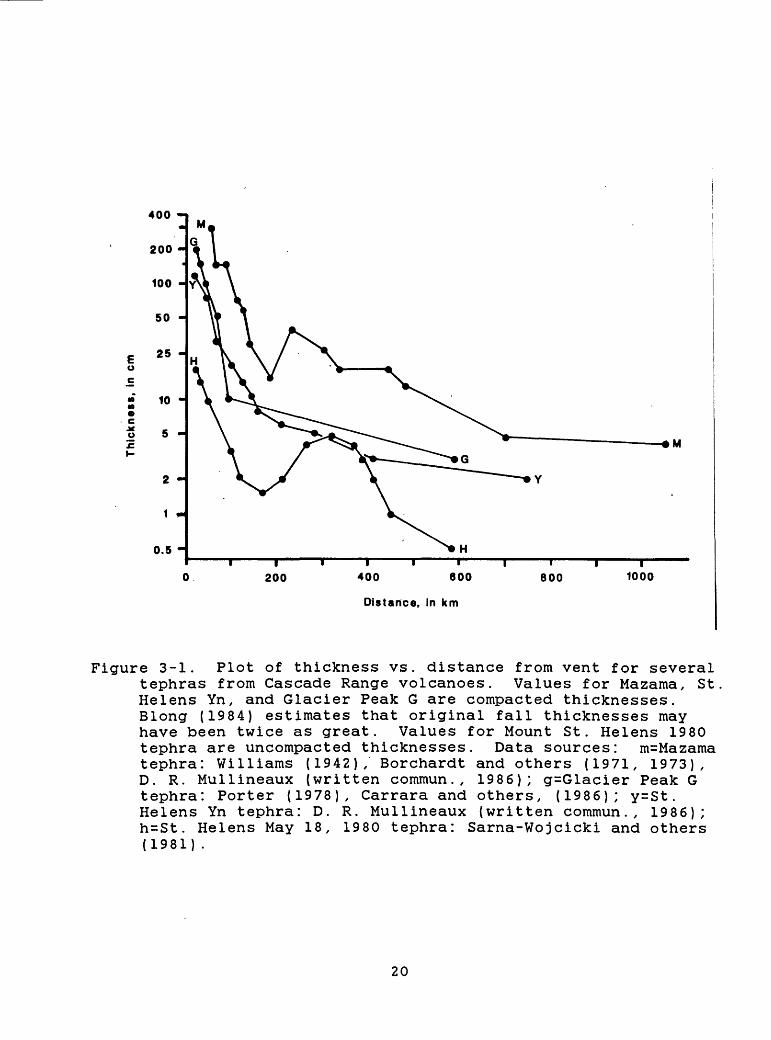
Tephra consists of fragments of lava or rock blasted into the air by explosions or carried upward by a convecting column of hot gases (e.g., Fisher and Schmincke, 1984; Shipley and Sarna- Wojcicki, 1983). These fragments fall back to earth on and downwind from their source volcano to form a tephra, pyroclastic- fall, or volcanic "ash" deposit. Large fragments fall close to the erupting vent, and progressively smaller ones are carried farther away by wind. Dust-size particles can be carried many hundreds of kilometers from the source. Tephra deposits blanket the ground with a layer that decreases in thickness and particle size away from the source. Near the vent, tephra deposits may be tens of meters thick. According to Blong (1984), rates of drift of clouds containing ash are usually in the range of 20-100 km/hr, but can be higher where wind speeds are higher.
Tephra deposits consist of combinations of pumice, glass shards, dense-rock, and crystals that range in size from ash (< 2 mm), through lapilli (2-64 mm), to blocks (> 64 mm). Eruptions that produce tephra range from those that eject debris only a few meters into the air, to cataclysmic explosions that throw debris to heights of several tens of kilometers. Explosive eruptions that produce voluminous tephra deposits also typically produce pyroclastic flows.
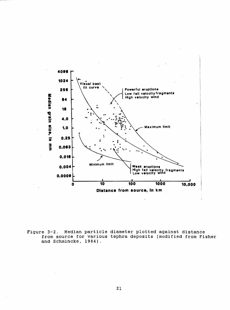
Effects of tephra are closely related to the amount of material deposited and its grain size. Thickness versus distance relationships for several well-known tephra deposits in the Cascade Range are shown in Figure 3-1. Figure 3-2 shows median particle diameter versus distance from source for various tephra deposits. The relationship generally approximates an exponential one, but shows wide scatter. Within about 100 km of a vent, the median particle diameter of a tephra deposit varies by several orders of magnitude depending on the intensity of the eruption, fall velocity of particles, and velocity of the wind. Beyond several hundred kilometers, the mean particle diameter typically is silt-size (about 0.063 mm) or less, but still shows considerable variation.
Tephras generally do not completely destroy facilities or kill people; instead they adversely affect both in many ways. Tephra can be carried to great distances and in all directions; no site in the Pacific Northwest is immune from tephra hazards. The magnitude of hazard from tephra varies directly with deposit thickness. In general, deposit thickness and grain size decrease with increasing distance from a vent. However, the tephra fall from the May 18, 1980, eruption of Mount St. Helens displays a secondary maximum of tephra thickness about 300 km from the volcano (Fig. 3-1; Sarna-Wojcicki and others, 1981). Carey and Sigurdsson (1982) proposed that aggregation of very fine ash into larger particles caused premature fallout at the secondary thickness maximum; they suggested that the same process may accompany other tephra eruptions. The few data points for some of the larger tephra falls in Figure 3-1, and the problems of
19
400 -
200 -
100 -
50 -
25 -
0.5 -
200 400 600
Distance, in km
800 1000
Figure 3-1. Plot of thickness vs. distance from vent for several tephras from Cascade Range volcanoes. Values for Mazama, St Helens Yn, and Glacier Peak G are compacted thicknesses. Blong (1984) estimates that original fall thicknesses may have been twice as great. Values for Mount St. Helens 1980 tephra are uncompacted thicknesses. Data sources: m=Mazama tephra: Williams (1942), Borchardt and others (1971, 1973), D. R. Mullineaux (written commun., 1986); g=Glacier Peak G tephra: Porter (1978), Carrara and others, (1986); y=St. Helens Yn tephra: D. R. Mullineaux (written commun., 1986); h=St. Helens May 18, 1980 tephra: Sarna-Wojcicki and others (1981) .
20
a
£ N*
33
4096 r
1024
256
64
16
4.0
1.0
0.25 '
0.063
0.016
0.004
0.0009
0
bestPowerful eruptionsLow fall veiocityfragmentsHigh velocity wind
Minimumeruptions
High fall velocity fragments Low velocity wind
10 100 1000
Distance from source, In km10,000
Figure 3-2. Median particle diameter plotted against distancefrom source for various tephra deposits (modified from Fisher and Schmincke, 1984).
21
determining original fall thicknesses from prehistoric deposits, leaves open the possibility of secondary thickness maxima in these layers. The tephra-thickness plot for Mazama tephra is a composite from many sources and suggests that a secondary thickness maximum may occur in the Mazama tephra at about 200-500 km from its vent. Alternatively, it may reflect varying methods used by different workers to determine original fall thickness.
Close to an erupting vent, the main tephra hazards to man- made structures include high temperatures, burial, and impact of falling fragments. Large blocks thrown on ballistic trajectories from an erupting vent can damage structures and kill or injure unprotected people. Most blocks will fall within 5 km of the vent (Blong, 1984), but unusually powerful explosions may throw some blocks at least twice as far (Crandell and Hoblitt, 1986). Hot tephra may set fire to forests and flammable structures, but this is not likely to be a hazard beyond a distance of 15-20 km. Structural damage can also result from the weight of tephra, especially if it is wet. A tephra layer 10 cm thick may weigh 20- 100 kg/m2 when dry, but 50-150 kg/m2 when wet (Crandell and others, 1984). Also, tephra is much more cohesive when wet than when dry, and can adhere to steeper surfaces and is much more difficult to remove. Tephra 10 cm or more thick may cause buildings to collapse {Blong, 1984, p.212). Drifting of tephra by winds can locally increase accumulations and loads on sloping structures far above that resulting from unmodified fall thicknesses.
At distances of tens to hundreds of kilometers, the chief hazards from tephra falls are the effects of ash on machinery and electrical equipment and on human and animal respiratory systems. Ash only 1 cm thick can impede the movement of most vehicles and disrupt transportation, communication, and utility systems (Schuster, 1981, 1983; Warrick and others, 1981). Machinery is especially susceptible to the abrasive and corrosive effects of ash {Schuster, 1981, 1983; Shipley and Sarna-Wojcicki, 1983).
Specific possible effects of airfall tephra on nuclear power plants have been outlined by Shipley and Sarna-Wojcicki (1983). They include (1) loading of structures, particularly by thick accumulations of wet tephra, (2) clogging of water and air filtering systems by influx of tephra, (3) abrasive effects of ash on machinery, (4) corrosion and shorting out of electrical systems by freshly fallen ash {Sarkinen, 1980), (5) effects of tephra accumulations in circulation of water-cooling systems, and (6) a variety of secondary or indirect effects on maintenance and emergency systems that may be impacted by factors 1-5. Shipley and Sarna-Wojcicki (1983) also pointed out the likelihood of "cascading effects", when the impact of tephra on one function or group of functions impairs additional dependent systems, each of which may produce further cascading effects.
In addition to the specific effects discussed above, the fall of tephra may severely decrease visibility or cause darkness, which could further disrupt transportation, disrupt outdoor activities, and possibly result in psychological stress and panic
22
even among people whose lives are not threatened (Blong, 1984). These effects could impair the ability of personnel to perform even routine tasks in areas affected by tephra fall. A wide range of compositions and volumes of tephra have been erupted during the past 15,000 years from Cascade volcanoes (Appendix A). These tephra deposits range in volume from the 116-km3 Mazama tephra (Bacon, 1983; Druitt and Bacon, 1986) to those of only a few thousand cubic meters. The May 18, 1980 eruption of Mount St. Helens deposited an estimated minimum volume of 1.1 km3 of uncompacted tephra on areas east-northeast of the volcano (Sarna- Wojcicki and others, 1981). Most tephra eruptions in the Cascade Range have produced elongate lobe-shaped deposits that extend primarily into a broad sector northeast of the source volcano owing to prevailing wind directions (Table 5-2).
Relatively small volumes (< 0.1 km3 ) of basaltic and basaltic-andesite tephra have been erupted at many vents during Holocene time. Such eruptions have been far less explosive than more silicic eruptions and have produced cinder cones and tephra deposits that are restricted chiefly to within a few tens of kilometers downwind. Similar small-volume eruptions of tephra are anticipated in the future at new vents within fields of basaltic volcanism in the Cascade Range (section 4.15).
3.4 Emission of volcanic gases
All magmas contain dissolved gases that are released both during and between eruptive episodes. Volcanic gases generally consist predominantly of steam (H2 0), followed in abundance by carbon dioxide and compounds of sulfur and chlorine (Wilcox, 1959; Thorarinsson, 1979). Minor amounts of carbon monoxide, fluorine and boron compounds, ammonia, and several other compounds are found in some volcanic gases.
The distribution of volcanic gases is mostly controlled by the wind; they may be concentrated near (1-10 km) a vent but become diluted rapidly downwind. Even very dilute gases can have a noticeable odor and can harm plants and some animals tens of kilometers downwind from a vent.
Within about 10 km of a vent, volcanic gases can endanger life and health as well as property. Acids, ammonia, and other compounds present in volcanic gases can damage eyes and respiratory systems of people and animals, and heavier-than-air gases, such as carbon dioxide, can accumulate in closed depressions and suffocate people or animals. Corrosion of metals and other susceptible materials can also be severe (Crandell and others, 1984; Blong, 1984).
3.5 Other hazardous events associated with volcanic activity
In addition to flowage, tephra, and gas hazards associated with volcanic eruptions, seismicity that typically precedes and accompanies eruptions, and atmospheric shock waves resulting from explosions can be hazardous to structures and people. The most
23
severe effects of volcanic seismicity are chiefly limited to within a few tens of kilometers of a vent, while atmospheric shock waves can be hazardous at much greater distances.
3.5.1 Volcanic seismicitvThree main sources of earthquakes in the vicinity of
volcanoes (Blong, 1984) are (1) those generated by the movement of magma or by formation of cracks through which magma can move, and those resulting from gas explosions within a conduit; (2) other earthquakes that result from readjustments of a volcanic edifice following eruption or movement of magma; and (3) tectonic earthquakes, which may also facilitate the rise of magma. Volcanic earthquakes belonging to the first category rarely have Richter magnitudes greater than 5.0 (Okada and others, 1981; Latter, 1981) and generally have foci at depths of less than 10 km. Damage from such earthquakes is limited to a relatively small area (Rittmann, 1962; Shimozuru, 1972).
The relationship between volcanic activity and earthquakes of categories 2 and 3 above is less well understood. Few quantitative data are available concerning the maximum magnitude of such earthquakes, although events larger than magnitude 5 have been described. A sequence of tectonic earthquakes that occurred near Mammoth Lakes, California, in 1980 included four events of magnitude 6+ (Urhammer and Ferguson, 1981); these may have been triggered by magmatic processes (Bailey, 1981). One of the largest earthquakes of possible magmatic origin occurred at Sakura-jima volcano, Japan, in 1914. The earthquake had a focal depth of 13 km, a magnitude of 6.7 (Shimozuru, 1972), and caused considerable damage and some loss of life in Kagoshima, 10 km from the volcano. Earthquakes at least as large as magnitude 7.2 have occurred on Kilauea volcano, Hawaii (Tilling and others, 1976); however, these earthquakes are related to displacements of large sectors of the volcanic edifice rather than to a specific volcanic event (Swanson and others, 1976) and thus resemble tectonic earthquakes.
In summary, earthquakes directly associated with movement or eruption of magma seldom exceed a magnitude of about 5.0, and structures at distances greater than a few tens of kilometers from the volcano are not likely to be damaged by such events. Nuclear power plants situated outside of the proximal-hazard zone (see Chapter 5) are not likely to be damaged by volcanic seismicity. Volcanoes located in geologic settings that are tectonically active are likely to be at risk from tectonic earthquakes that are far larger than volcanogenic ones. Power plants sited and designed to withstand the maximum credible tectonic earthquake should not be threatened by volcanogenic seismicity.
3.5.2 Atmospheric shock waves induced by eruptionsEruption induced atmospheric shock waves are strong
compressive waves driven by rapidly moving volcanic ejecta. Although most volcanic eruptions are not associated with such waves, a number of examples are known. Some of the eruptions best
24
known for this type of behavior are: Vesuvius, 1906 {Ferret, 1912); Krakatau, 1883 (Verbeek, 1885, in Simkin and Fiske, 1983); Tambora, 1815 (Stewart, 1820); Sakura-jima, 1914 (Omori, 1916); and Asama, 1958 (Aramaki, 1956). Air-shock waves can be sufficiently energetic to damage structures far from their source. The 1815 eruption of Tambora, on the island of Sumbawa, produced a shock wave that broke windows at a distance of about 400 km (Stewart, 1820). In 1883, a barograph deflection of about 7 millibars (0.7 kPa) was recorded 150 km from Krakatau {Strachey, 1888). Air shocks can apparently couple to the ground strongly enough to cause damage to buildings at 100 km (Simkin and Howard, 1970).
Few quantitative observational data are available upon which to construct a model relating shock strength (overpressure and rate of compression), distance, and energy release. Considering the uncertainties, the simple theory of self-similar motion is adequate for a first approximation. This theory (Thompson, 1972; Landau and Lifshitz, 1959; Zeldovich and Razier, 1966) was developed for the motion of the atmosphere in response to nuclear blasts. The source pressures in volcanic explosions, however, are much lower than those in nuclear blasts.
Assume (1) the atmosphere is uniform in structure and (2) is at rest at the time of the eruption; (3) at time t = 0, a large energy, E, is released at the volcano; (4) the dimensions of the region over which E is released are small compared to the distances of interest here; (5) the resulting motion of the atmosphere is spherically symmetric. For shock pressures of 6 bars or more, the shock pressure will decay as 1/R3 :
P s = E/R3 ,(1 bar = 1 X 10 s dyne cm' 2 ) (1 erg = 1 dyne-cm) (1 cm = 1 X 10' 5 km)
where Ps is the pressure immediately behind the shock front, R is the radial distance from the source, and E is the energy of the shock wave. Volcanologists currently consider about 500 bars as an upper limit to the initial value of Ps (Self and others, 1979; Kieffer, 1981). The value here assigned to E is 5 x 10 2 * ergs, the energy thought to have been dissipated in the atmosphere by the 1883 eruption of Krakatau (Press and Harkrider, 1966), perhaps the greatest explosion ever recorded. This eruption was of the same order of magnitude as the climactic eruption of Mount Mazama 6850 yr ago (Friedman and others, 1981; Simkin and others, 1981), taken here as the largest credible future eruption of a Cascade volcano. Using the Krakatau energy value,
Ps = 5 x 10 24 /R3 .
This equation holds approximately between the source and the radial distance at which P. decays to about 6 bars, about 9 km. Beyond this distance, strong shock theory is inappropriate, and
25
the pressure decays approximately as 1/R:
Ps/Pss = Rss/R,
where Ps s is the pressure (6 bars) at the lower limit of the strong shock regime, and Rs s is the distance at the limit of the strong shock approximation. For the case considered here (E = 5 x 10 2 * ergs, Rs s = 9 km), Ps is about 1 bar at 50 km, the radius of the proximal-hazard zone (Chapter 5), and is about 0.4 bars at 150 km (approximately 50 times the observed value at this range at Krakatau). The wave would be calculated to decay to 0.1 bar, the threshold for damage, at about 540 km. These overpressure estimates are maximum values for at least two reasons. First the energy we have used is probably an upper limit on the energy of Krakatau. Secondly, the density structure of the atmosphere, neglected in this formulation, tends to reduce the pressure by a factor of 2 to 3 in the region of a few tens to hundreds of kilometers.
A more empirical approach is to take the observed damage threshold distance, assume an overpressure of 0.1 bar, then calculate the overpressure at lesser distances. The 1883 eruption of Krakatau caused windows to break at 150 km from source (Verbeek, 1885, in Simkin and Fiske, 1983, p. 202). Accordingly, Rss = 2.5 km. Then, E = 9 x 10 22 ergs, and Ps =0.3 bar at 50 km.
Based on the preceding analyses, a reasonable worst-case overpressure range for large eruptions of Cascade volcanoes at 50 km, the margin of the proximal-hazard zone, is about 0.3-1.0 bars.
One of the only detailed calculations done of atmospheric response to an observed volcanic eruption event is that of Bannister (1984), in which he calculated the response of the atmosphere within 1000 km to the accelerations of the May 18 blast at Mount St. Helens. The calculated overpressures were in good agreement with barograph records observed in the range 50 to 400 km. The peak positive overpressure at 10 km was 1600 Pa (0.16 bar) and at 50 km was nearly 400 Pa (0.04 bars). These pressures are directly dependent on the initial velocity and time history of the ejecta. Since ejecta velocities substantially larger than the 147 m/s used by Bannister for the Mount St. Helens ejecta are plausible, higher overpressures for larger events are conceivable. These cannot be predicted without numerical modelling, but we believe that overpressures that could exceed the Mount St. Helens example by factors of 2, 3, or 5 are plausible. This reasoning supports the above estimates of worst case overpressures of several tenths of a bar. These estimates, however, are too poorly supported to be used as design criteria. If eruption-induced overpressures are to be considered in design, we recommend that additional research be undertaken to develop better-constrained overpressure estimates.
26
CHAPTER 4
ERUPTIVE HISTORY AND VOLCANIC-HAZARDS ASSESSMENT FOR CASCADE VOLCANOES
4.1 Introduction
This chapter briefly describes the eruptive history of each major Cascade Range volcano and assesses the potential hazards around those volcanoes from future eruptions. Eruptions of the relatively recent geologic past are emphasized because the volcanic behavior they represent probably best characterizes the most expectable types of activity within the next 100 yr. For most volcanoes, we review the Holocene (past 10,000 yr) record in most detail. However, the Pleistocene (10,000-1.8 million yr ago) eruptive record is discussed at volcanic centers that had little activity in Holocene time or that had markedly different activity in Pleistocene than in Holocene time. The past activity and potential hazards from eruptions of basaltic volcanoes and volcanic fields of the Cascade Range are also described.
We use several terms in this and subsequent chapters to refer to intervals of geologic time, in addition to Holocene and Pleistocene. The Pleistocene and Holocene Epochs comprise the Quaternary Period. The past 20,000 yr is called the latest Quaternary. We subdivide the Pleistocene into 3 parts: early (1.8 million-730,000 yr ago), middle (730,000-125,000 yr ago), and late (125,000-10,000 yr ago). We also define time intervals based on regional glacier expansions and recessions. The late Wisconsin glaciation in the Cascades culminated between 22,000 and 18,000 yr ago and largely ended between 14,000 and 12,500 yr ago (Porter and others, 1983). We use the term late glacial to refer to the time period between 20,000 and 15,000 yr ago; postglacial refers to the past 12,000-15,000 yr.
Many ages for deposits and events between several hundred and 40,000 yr old reported in this and subsequent chapters are based on radiocarbon dates. Owing to variations in the radiocarbon content of the atmosphere during this time period, a given radiocarbon date does not necessarily represent an equal number of calendar years (e.g., Pearson and Stuiver, 1986; Stuiver and others, 1986; Stuiver and Pearson, 1986). For radiocarbon dates less than about 3000 yr the difference between radiocarbon years and calendar years is as much as 200 yr. In contrast, corresponding calendar dates for radiocarbon dates between 3000 yr and 7000 yr, are as much as 1000 yr greater than the radiocarbon dates. For example, the climactic eruption of Mount Mazama has a radiocarbon date of 6845 yr (Bacon, 1983); however, the corresponding calendar date is about 7600 yr. We have not corrected any of the radiocarbon dates used in this report. Dates for events based on historical records or tree-ring studies are given as calendar years A.D.
Names of volcanic rocks are based on silica content. Basalts have less than 53% silica, basaltic andesites have 53-58%,
27
andesites have 58%-63%, dacites have 63-68%, and rhyolites, with which we include rhyodacites, have more than 68%.
A compilation of the eruptive activity of the volcanoes, upon which most of the following discussion is based, is contained in Appendix A. We stress that, for at least 4 reasons, the compilation is incomplete. First, all volcanoes have not been studied in the same detail. Second, the difficulty in determining the origin of some products of volcanism may prevent correct interpretation of past volcanic events. Third, the stratigraphic record is incomplete owing to erosion and to burial of some deposits by those of subsequent eruptions. Fourth, some volcanic events, even highly energetic ones, may leave no deposit or only a deposit that is very thin and difficult to find and interpret. For these reasons, the compilation should be regarded as only a minimum representation of Cascade volcanism.
The compilations are used to determine minimum frequencies of past events at each volcano and to draw graphs showing the frequency distribution of the lengths of each type of flowage deposit at each volcano. In Chapter 5, we use this information to define hazard zones around the volcanoes. A great uncertainty exists in estimating the lengths of past lahars and pyroclastic flows. Field evidence seldom reveals the distal end of these flowage deposits, so the farthest downvalley extent of a deposit provides only a minimum estimate of its distance traveled. Thus, distances traveled reported here are minimum values. Lengths of lava flows are typically more reliable.
Most of the plots of frequency versus length or minimum distance traveled show the expectable inverse relationship events that affect areas close to a volcano are more numerous than those that affect more distant areas. However, the O-to-5-km class of lahars and pyroclastic flows at many volcanoes record fewer events than do longer distance classes. There are at least four reasons why the O-to-5-km class is under-represented: (1) Small-volume deposits are less apt to be recognized than large-volume ones, (2) on steep slopes the deposits are typically thin and easily eroded, (3) some large-volume and highly energetic flowage phenomena are erosive near their sources and may not leave any deposits, and (4) small deposits may accumulate at valley heads in debris fans and may not be well exposed for study.
4.2 Mount Baker
4.2.1 Eruptive historyMount Baker (Fig. 4-1) is a Pleistocene stratovolcano of
chiefly andesite lava flows and pyroclastic debris that overlaps rocks of an older eruptive center (Coombs, 1939), which are dated at about 400,000 yr (Easterbrook and Rahm, 1970). Construction of the present cone was largely completed prior to late Wisconsin glaciation. Postglacial events (Appendix A, Figs. 4-2 to 4-5) are dominated by debris avalanches and lahars, which repeatedly flowed down valleys that head on the volcano. Eruptions also produced tephra falls, lava flows from both summit and satellite vents, and
28
122"
British Columbia
ConcretetrLower Baker Dam
49«
Figure 4-1. Location map of Mount Baker volcano, Washington
29
fZ/7110-15 15-20 20-30 JO-4O 4O-50 50-100 >-100
Minimum Distance Traveled (km)
Figure 4-2. Bar graph showing number versus minimum distance traveled for postglacial lahars and debris avalanches at Mount Baker, Washington (data in Appendix A).
10 -
00 r~
60
r~
80 100
Minimum Distance Traveled (km)
Figure 4-3. Plot showing cumulative number versus minimum distance traveled for postglacial lahars and debris avalanches at Mount Baker, Washington (data in Appendix A). Numbers above the data points are percentages of lahars and debris avalanches whose minimum distances traveled equal or exceed the indicated distance.
30
c n^ rt
CD
Q)
l-{
CO
P)
£k3*
<
tH
- (D
.Ul
IQ
CDrt
Q
.0
TO3
n>
p)O
»-{
^~.
i~{
P.
OQ)
t3
«-{rt
0
P)
rt 3
"H
- IQ
3
1-
CO
>
O
O
CD
M 3
3
iQ
0
3>
o c
r I
CDP)
"{CO
rt
<H
- CD
o n CO
M>
£
h-
COo £
3CO
H
-
rt 3 £
S3
O c a
H^
j-
rt
CO rttd
p)
Q)
3W
Oa>
a>n X
C
0 Ui
Ul 1
.0 o
1 -
5 5;
3
§'
9
?-
1
^0 8
gr>
i
-I
^
£ ?
?
11-
0 s 1 -
s 01
0 1 _
o o V 1 8 "
Num
ber
of
Pyro
cla
sttc
Flo
w«
1 1
1 1
1 1
1 |
1 |
| |
P$$M
^S
$\3 ^
1 1
1
C nJf
*O
(D*o
o*O
co
»^
(D rt
i
3
iQ
£>
a M
H
- P
)X
O H
- 00
tf
P)
P)t->
nH
--IQ
P) ^
<
P) £
M>
h-1
CO0
3"
<«
(-»
<4
\J
CO ^ !"*
P)
3
rtiQ
0
CC
3
rt
(D i-i
TO W C
D CD
«-{
n
co%
C CO
P)
3CO
H
"3"
3
i_i.
|_i.
3
3iQ
C
rt 3
0 3
H-
CD
CLIQ
P) rt
rt 3
"P)
M>
H-
O
3 ^
C
o 1 -
Ui en 1
.o 0 a>
E
_5;
u-
f * 1?.
^ s ?6 " S S
"
Ui
0 ^ .
o
o V 1 8 "
Nu
mb
er
of
Lava
F
low
s
> -*
M
U
*
L 1
1 1
^^^^^
pyroclastic flows and accompanying pyroclastic surges (Hyde and Crandell, 1978). Many of the debris avalanches and lahars are not directly associated with evidence of magmatic eruptions, and may have been triggered by minor phreatic eruptions, earthquakes, or in other ways.
Historical activity of Mount Baker includes several explosions during the mid-19th century {Coombs and Howard, 1960) and numerous small-volume debris avalanches between 1958 and 1979 (Frank and others, 1975; Frank, 1983) . Beginning in 1975, heightened thermal activity manifested by increased fumarolic emission and by melting of ice and snow near the summit caused concern that an eruption might be imminent (Frank and others, 1977) .
4.2.2 Volcanic-hazards assessmentThe postglacial record of activity at Mount Baker indicates
that the greatest potential hazard is from debris avalanches and lahars of hydrothermally altered material and related floods in the valleys draining the volcano (Frank and others, 1977; Hyde and Crandell, 1978; Frank, 1983). Large-volume events of these types have repeatedly affected the valleys; the mean frequency of these events during the past 600 yr has been about once per 150 yr (Hyde and Crandell, 1978). Parts of valleys on and close to the volcano have been affected much more frequently. Large floods related to lahars or other types of eruptive activity could inundate the flood plains of the Nooksack and Skagit Rivers to their mouths. However, the hydroelectric dams and reservoirs on the Baker River (a tributary of the Skagit) could trap debris avalanches, lahars, and floods and reduce hazards in downstream areas (Hyde and Crandell, 1978). An analysis by Shreve (in Frank and others, 1977) indicates that debris avalanches and lahars of similar size to those of postglacial age would probably not generate waves high enough to overtop the dam of Baker Lake, if the reservoir were at a low to intermediate level.
An event of low probability, but of potentially serious consequences, would be a debris avalanche or lahar of a volume unprecedented at Mount Baker in postglacial time (Frank, 1983). Such an event would require disrupting a large part of the edifice at one time. The potentially huge volume of hydrothermally altered, clay-rich material present in the volcano and the continual production of such material, coupled with steep slopes and great topographic relief, suggest that such an event is possible. An avalanche and lahar at Mount Baker could be as large as the 600-yr-old Electron Mudflow at Mount Rainier, which had a volume of more than 0.15 km3 and inundated valley bottoms more than 50 km away (Crandell, 1971). If an avalanche or lahar of similar or larger volume were to descend the east flank of the volcano and enter Baker Lake while the reservoir level were high, a wave large enough to overtop the dam might be generated, which would have catastrophic consequences downstream. Lava flows, pyroclastic flows, and pyroclastic surges have occurred less frequently at Mount Baker than debris avalanches and lahars and
32
therefore are considered less likely to occur in the future (Hyde and Crandell, 1978). During postglacial eruptions, lava flows have been confined to within 15 km of the volcano (Fig. 4-4; Hyde and Crandell, 1978). Future lava flows are unlikely to extend much farther unless they erupt from satellitic vents on the distal flanks of the volcano. Hyde and Crandell (1978) show areas that could be affected by future pyroclastic flows and surges limited to within 15-25 km of the volcano based on the extent of postglacial deposits they recognized. Heller and Dethier (1981) found a postglacial pyroclastic-flow deposit in the lower Baker River valley which suggested to them that the hazard zone of Hyde and Crandell (1978) should be extended by 5 km.
One tephra eruption at Mount Baker in postglacial time had an estimated volume of 0.1-0.2 km3 ; two or three others had volumes less than 0.1 km3 (Appendix A). Hyde and Crandell (1978) estimate that beyond 50 km from the volcano, tephra thicknesses from future eruptions of similar size will probably not exceed 5 cm. Based on its past activity (one tephra eruption equal to or exceeding 0.1 km3 in the past 12,000 yr), the probability of such an explosive eruption in any one year is about 1 X 10"* . The dominantly andesitic composition of Mount Baker products suggests that tephra eruptions of more than a few tenths of a cubic kilometer are much less likely than at volcanoes that erupt more silicic magmas.
4.3 Glacier Peak
4.3.1 Eruptive historyGlacier Peak (Fig. 4-6), geographically the most remote of
the Cascade volcanoes, is a Pleistocene and Holocene composite volcano composed chiefly of dacite, with a minor amount of basalt erupted from satellitic vents (Tabor and Crowder, 1969; Beget, 1982, 1983). Large explosive eruptions about 11,000-12,000 yr ago (Appendix A) produced: (1) two tephra-fall deposits of large (>1 km3 , dense-rock equivalent) volume, which are widely distributed east of the volcano (Lemke and others, 1975; Porter, 1978; Sarna- Wojcicki and others, 1983; Mehringer and others, 1984), (2) seven tephra falls of small (0.01-0.1 km3 ) volume (Porter, 1978), and (3) many pyroclastic-flow deposits and lahars that form thick (locally >100 m) fills in the valleys that head on the volcano (Tabor and Crowder, 1969; Beget, 1982, 1983). The two large tephra eruptions were separated in time by probably no more than a few centuries (Mehringer and others, 1984). Tephra of each eruption is about 1 m thick at a distance of 50 km downwind from the volcano, and about 0.5m thick at a distance of 70 km (Fig. 3- 1; Porter, 1978). These deposits represent two of the largest Cascade tephra eruptions of postglacial time, although they are less voluminous than the tephra fall that accompanied the climactic eruption of Mount Mazama (about 34 km3 , dense-rock equivalent).
Pyroclastic flows associated with the eruptive period of 11,000-12,000 yr ago traveled as far as 15 km from the volcano (Figs. 4-7 and 4-8), and lahars reached areas along the
33
Figure 4-6. Location map of Glacier Peak, Washington
34
100
17771i r^ i i i0-5 5-10 10-15 15-20 20-30 30-40
Minimum Distance Traveled (km)
4O-5O 50-100 >-100
Figure 4-7. Bar graph showing number versus minimum distancetraveled for postglacial pyroclastic flows at Glacier Peak, Washington (data in Appendix A).
140
130
0.0 0.0 0.0 0.0 0.0
20 40 60
Minimum Distance Traveled (km)
80
00 El
100
Figure 4-8. Plot showing cumulative number versus minimum distance traveled for postglacial pyroclastic flows at Glacier Peak, Washington (data in Appendix A). Numbers above the data points are the percentages of pyroclastic flows whose minimum distances traveled equal or exceed the indicated value.
35
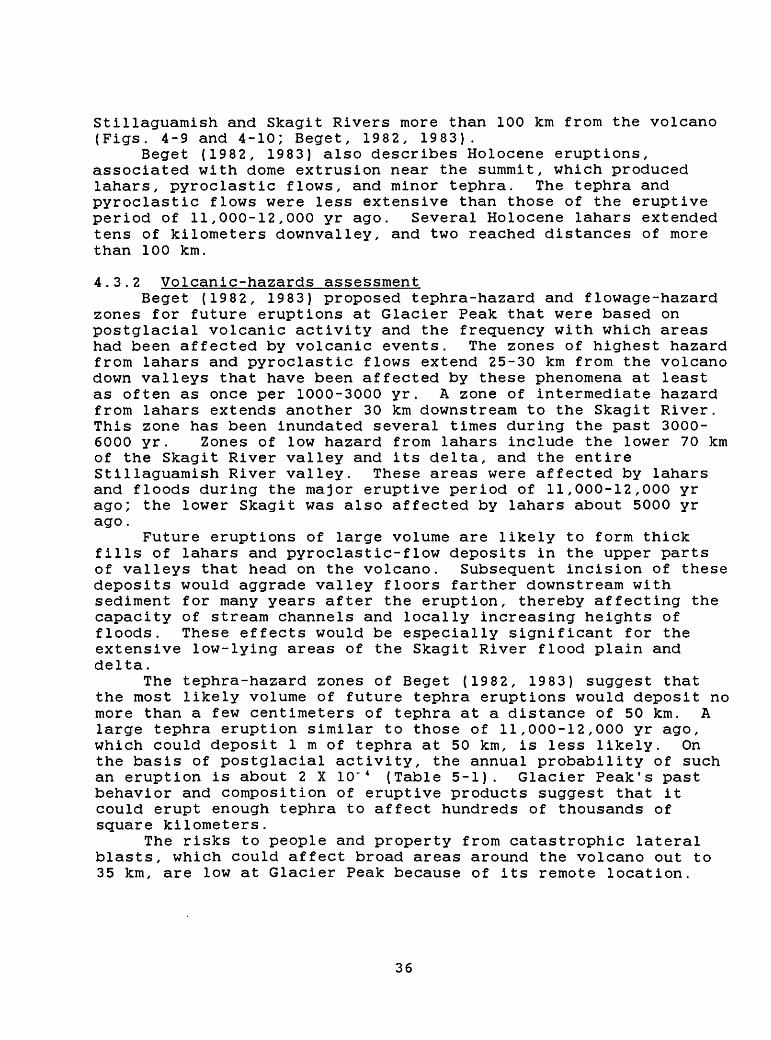
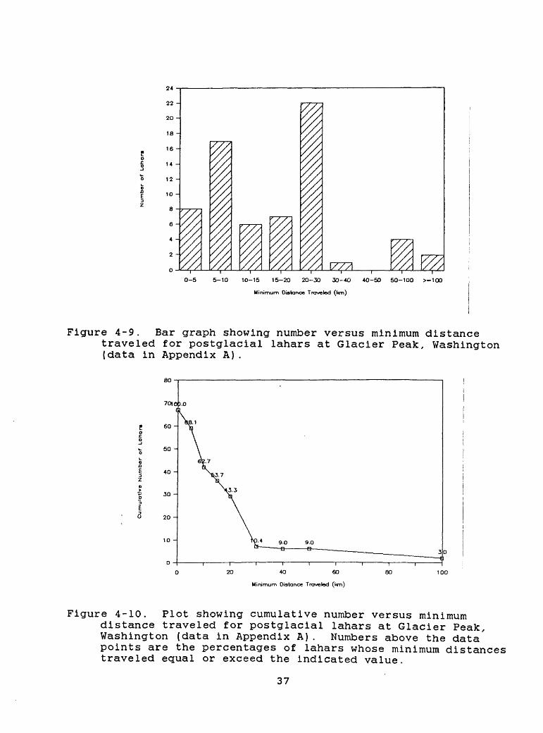
Stillaguamish and Skagit Rivers more than 100 km from the volcano (Figs. 4-9 and 4-10; Beget, 1982, 1983).
Beget (1982, 1983) also describes Holocene eruptions, associated with dome extrusion near the summit, which produced lahars, pyroclastic flows, and minor tephra. The tephra and pyroclastic flows were less extensive than those of the eruptive period of 11,000-12,000 yr ago. Several Holocene lahars extended tens of kilometers downvalley, and two reached distances of more than 100 km.
4.3.2 Volcanic-hazards assessmentBeget (1982, 1983) proposed tephra-hazard and flowage-hazard
zones for future eruptions at Glacier Peak that were based on postglacial volcanic activity and the frequency with which areas had been affected by volcanic events. The zones of highest hazard from lahars and pyroclastic flows extend 25-30 km from the volcano down valleys that have been affected by these phenomena at least as often as once per 1000-3000 yr. A zone of intermediate hazard from lahars extends another 30 km downstream to the Skagit River. This zone has been inundated several times during the past 3000- 6000 yr. Zones of low hazard from lahars include the lower 70 km of the Skagit River valley and its delta, and the entire Stillaguamish River valley. These areas were affected by lahars and floods during the major eruptive period of 11,000-12,000 yr ago; the lower Skagit was also affected by lahars about 5000 yr ago.
Future eruptions of large volume are likely to form thick fills of lahars and pyroclastic-flow deposits in the upper parts of valleys that head on the volcano. Subsequent incision of these deposits would aggrade valley floors farther downstream with sediment for many years after the eruption, thereby affecting the capacity of stream channels and locally increasing heights of floods. These effects would be especially significant for the extensive low-lying areas of the Skagit River flood plain and delta.
The tephra-hazard zones of Beget (1982, 1983) suggest that the most likely volume of future tephra eruptions would deposit no more than a few centimeters of tephra at a distance of 50 km. A large tephra eruption similar to those of 11,000-12,000 yr ago, which could deposit 1 m of tephra at 50 km, is less likely. On the basis of postglacial activity, the annual probability of such an eruption is about 2 X 10"* (Table 5-1). Glacier Peak's past behavior and composition of eruptive products suggest that it could erupt enough tephra to affect hundreds of thousands of square kilometers.
The risks to people and property from catastrophic lateral blasts, which could affect broad areas around the volcano out to 35 km, are low at Glacier Peak because of its remote location.
36
24
22
20
18
16
14 -
12 -
10 -
8
6 -
4 -
2
0 / 177710-5 5-10 10-15 15-20 20-30 30-40
Minimum Distance Traveled (km)
40-50 50-100 >-100
Figure 4-9. Bar graph showing number versus minimum distancetraveled for postglacial lahars at Glacier Peak, Washington (data in Appendix A).
20 -
100
Minimum Distance Traveled (km)
Figure 4-10. Plot showing cumulative number versus minimumdistance traveled for postglacial lahars at Glacier Peak, Washington (data in Appendix A). Numbers above the data' points are the percentages of lahars whose minimum distances traveled equal or exceed the indicated value.
37
4.4 Mount Rainier
4.4.1 Eruptive historyThe construction of Mount Rainier volcano (Fig. 4-11)
probably began in early or middle Pleistocene time (Crandell, 1963; Crandell and Miller, 1974). Multiple lahars, alluvium, and layers of volcanic ash, all presumably derived from Mount Rainier or its ancestor, are interbedded with glacial deposits in the southeastern Puget Sound lowland. Some of these deposits have reversed magnetic polarities and are older than an 840,000-yr-old layer of volcanic ash (Easterbrook and others, 1981; Easterbrook and others, 1985). The bulk of the present cone consists of andesite lava flows (Fiske and others, 1963) with normal magnetic polarity, and are therefore probably less than 730,000 yr old; limited K-Ar dating supports this conclusion (Crandell and Miller, 1974). Erosion, chiefly by glaciers and debris avalanches, has predominated over cone building during the past 100,000 yr at Mount Rainier.
Postglacial eruptive activity at Mount Rainier (Appendix A) produced 11 layers of tephra, at least one pyroclastic flow that was restricted to within 10-15 km of the summit, and the summit lava cone (Crandell and Mullineaux, 1967; Crandell, 1969; Mullineaux, 1974). More than 60 debris avalanches and lahars (Figs. 4-12 and 4-13) swept down valleys heading on the volcano; the largest reached an arm of Puget Sound more than 100 km away (Crandell, 1971). Many of the large debris avalanches and lahars contain much hydrothermally altered material (Crandell, 1971); such material is still being produced by the volcano's active hydrothermal system (Frank, 1985).
The last major eruptive period at Mount Rainier occurred between about 2,500 and 2,200 years ago and produced a lava cone at the summit of the volcano, many lahars in several valleys, a pyroclastic flow on the west side of the volcano, and the most voluminous Mount Rainier tephra of postglacial time (Crandell and Mullineaux, 1967; Crandell, 1969). The tephra is about 15 cm thick 12 km east of the summit of the volcano and 8 cm at 25 km. Mullineaux (1974) estimated its original volume to be about 0.30 km3 .
The largest known explosive eruption of Mount Rainier occurred between about 30,000 and 100,000 years ago and is recorded by a pumice deposit that has been recognized northeast, east, and southeast of the volcano. The deposit is about 2 m thick at a site 12 km northeast of the present summit (D.R. Crandell, written commun., 1986). Its distribution and thickness farther east are not known, nor is it known whether the thickness of 2 m occurs along the axis of the lobe. This thickness at 12 km is greater than that of tephra layer Yn at a similar distance from Mount St. Helens (Mullineaux, 1986) but less than that of layers B and G from Glacier Peak (Fig. 3-1; Porter, 1978). Layers Yn, B, and G all have estimated volumes equal to or more than 1 km3 (Crandell and Mullineaux, 1978; Porter, 1978). The limited thickness data for the tephra layer at Mount Rainier suggest that
38
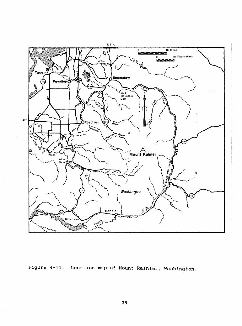
122 \
47 c
10 Miles
10 Kilometers
Figure 4-11. Location map of Mount Rainier, Washington
39
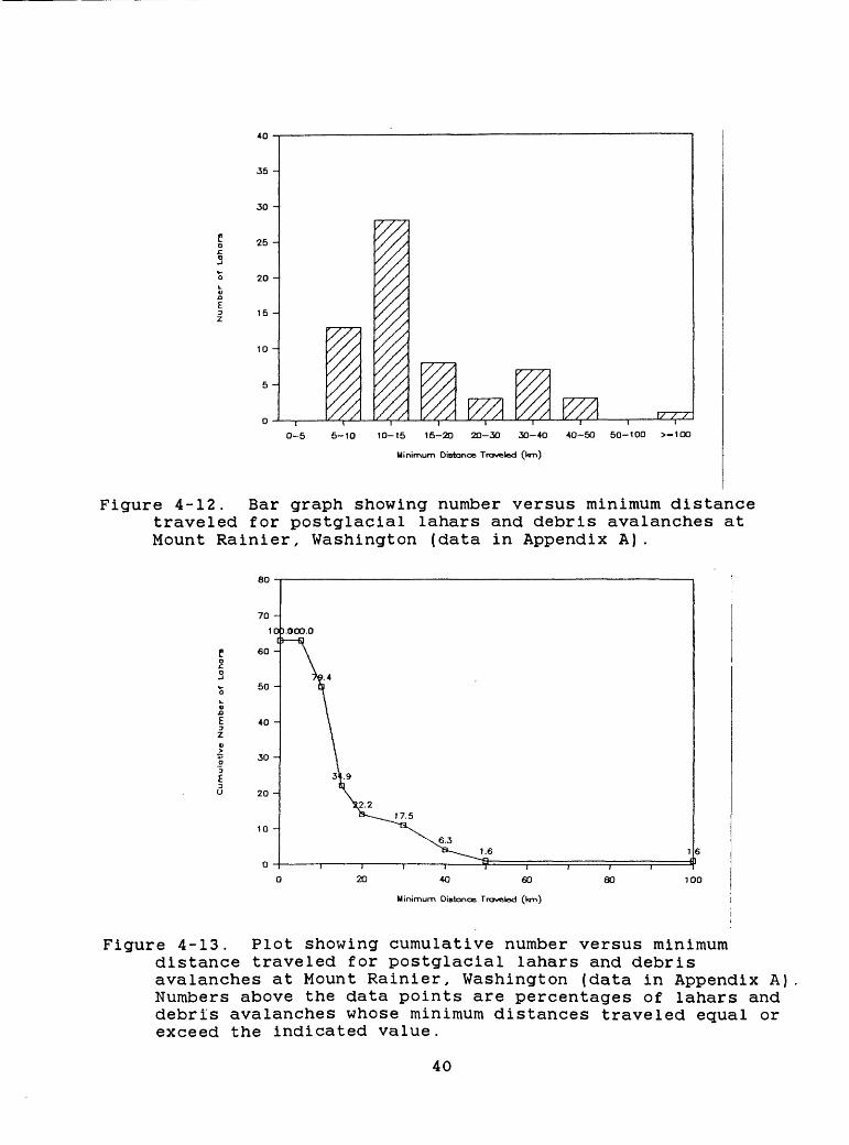
35 H
30 H
25 H
20 H
15H
10 H
0-5 5-10 10-15 15-20 20-30 30-40
Minimum Distance Traveled 0<m)
4O-50 50-100 >-100
Figure 4-12. Bar graph showing number versus minimum distance traveled for postglacial lahars and debris avalanches at Mount Rainier, Washington (data in Appendix A).
20 40 60
Minimum Distance Traveled (t<m)
Figure 4-13. Plot showing cumulative number versus minimum distance traveled for postglacial lahars and debris avalanches at Mount Rainier, Washington (data in Appendix A) Numbers above the data points are percentages of lahars and debris avalanches whose minimum distances traveled equal or exceed the indicated value.
40
it may have had a comparable volume (1-10 km3 ). Therefore, the volume of this late Pleistocene tephra is probably at least one order of magnitude greater than that of the most voluminous tephra of postglacial age.
4.4.2 Volcanic-hazards assessmentEleven pumice-producing eruptions occurred at Mount Rainier
during postglacial time (Mullineaux, 1974). The most likely future eruptive event, based on the Holocene history of the volcano, is a tephra eruption of small volume (Crandell, 1973), probably between 0.01 and 0.1 km3 . The probability of such an eruption in any one year, inferred from data in Appendix A, is about 1 X 10" 3 (Table 5-1). The effects of such an eruption would be minor beyond a distance of 50 km. The annual probability of an explosive eruption producing more than 0.1 km3 of tephra, which would have serious effects beyond 50 km, is about 1 X 10"* (Appendix A; Table 5-1).
An explosive eruption like that between 30,000 and 100,000 yr ago at Mount Rainier is even less likely. Other explosive eruptions may have occurred during that period, but their products have been removed or buried. The likelihood of such an eruption in any one future year is less than 1 X 10"* , and may be as low as 1 X 10" 5 .
The most likely future hazardous events at Mount Rainier are debris avalanches, lahars, and floods like those of the past that have repeatedly swept down the valleys heading on the volcano (Crandell and Mullineaux, 1967; Crandell, 1973). The frequency with which lahars have affected areas more than 20 km from the volcano (Appendix A), suggests that the annual probability of such an event is about 1 X 10" 3 . Larger, more hazardous events extending to distances of more than 50 km have an annual probability one order of magnitude less (1 X 10"* ). Large-volume events such as these could reach beyond the mountain front into the Puget Sound lowland and could inundate tens to hundreds of square kilometers in relatively densely populated areas.
The largest debris avalanches and lahars at Mount Rainier originated from parts of the volcano that contained large volumes of hydrothermally altered material (Crandell, 1971). Frank (1985) concludes that the upper west flank and the summit provide the largest potential sources of this material. This distribution suggests that any side of the volcano could be affected, but that the valleys that head on the west and northeast sides of the volcano are particularly vulnerable to large debris avalanches and lahars. Debris avalanches of large volume probably are most likely during eruptions but could also occur during dormant periods (Crandell, 1971; Frank, 1985).
All of the major rivers that drain Mount Rainier, except the Puyallup-Carbon, are dammed at distances that range from 40-80 km downvalley from the summit. If reservoirs were empty or nearly so, these dams could contain all but the very largest expectable lahars and floods.
41
4 . 5 Mount Adams
4.5.1 Eruptive historyMount Adams (Fig. 4-14) is composed of lava flows and
fragmental rocks of basaltic andesite and andesite; numerous satellitic vents on the flanks of the volcano have erupted rocks ranging from basalt to dacite (Hildreth and others, 1983). Most of the main cone is younger than 220,000 yr. Seven postglacial lava flows (Fig. 4-15) issued from flank vents (Hildreth and others, 1983), the youngest of which is between 6850 and 3500 yr old (J. W. Vallance, personal commun., 1986). Debris avalanches and lahars (Fig. 4-16 and 4-17) affected several valleys around the volcano during postglacial time; the longest lahar extended at least 52 km from the volcano (Hopkins, 1976; Vallance, 1986). A large amount of hydrothermally altered material in this and one other lahar and in one debris avalanche implies they originated as avalanches of wet, altered, clay-rich debris from near the summit (Vallance, 1986). The youngest such event was a debris avalanche that descended the southwest flank in 1921 A.D. Numerous debris flows generated by glacial and meteorologic processes occur frequently at Mount Adams, but typically affect areas within only a few kilometers of the volcano (J. W. Vallance, personal commun., 1987) . Postglacial eruptions and weak, diffuse fumarolic emissions in the summit area suggest that the volcano is capable of erupting again (Hildreth and Miller, 1984).
4.5.2 Volcanic-hazards assessmentThe postglacial record of volcanic activity at Mount Adams
(Appendix A, Figs. 4-15 to 4-17) indicates that the most likely events to occur in the future are eruptions from flank vents to form scoria cones and lava flows, and debris avalanches and lahars (Vallance, 1986). Lava flows would probably extend no farther than 10 km from their vents, which might lie as far as 10 km from the summit of the volcano. Therefore, the direct effects of lava flows are likely to be restricted to within 20 km of the summit of the volcano. Lava-flow eruptions, especially those on the upper part of the cone, could generate lahars and floods by melting ice and snow, and thereby affect valley bottoms far downstream.
Debris avalanches and lahars have originated on the southwest flank of Mount Adams with a mean frequency of about one per 1500 yr during the past 6000 yr (Vallance, 1986). No evidence indicates that any were accompanied by eruptive activity. The presence of hydrothermally altered material on the steep southwest and east flanks near the summit suggests that these areas are probable sources of future avalanches and lahars, similar in size to those of postglacial age.
A less likely event on Mount Adams is a debris avalanche and lahar perhaps an order of magnitude more voluminous than the largest of postglacial age (Vallance, 1986) . The greater the quantity of hydrothermally altered material lying on the upper slopes of the cone, the higher would be the probability for such an event. Hydrothermally altered material does exist on the upper
42
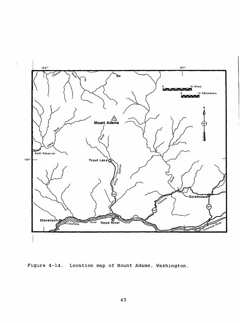
. 121°
!.46°
Figure 4-14. Location map of Mount Adams, Washington
43
5 -
2 -
1 -
0-5 5-10 10-15 15-20 20-30 30-4O 40-50 50-100 >-1OO
Minimum Length (km)
Figure 4-15. Bar graph showing number versus length forpostglacial lava flows at Mount Adams, Washington (data in Appendix A).
2 -
0-5 5-10 10-15 15-20 20-30 30-4O 40-50 50-100 >-100
Minimum Distance Traveled (l«m)
Figure 4-16. Bar graph showing number versus minimum distance traveled for postglacial lahars and debris avalanches at Mount Adams, Washington (data in Appendix A).
44
40 60
Minimum Distance Traveled (kr
80 100
Figure 4-17. Plot showing cumulative number versus minimum distance traveled for postglacial lahars and debris avalanches at Mount Adams, Washington (data in Appendix A). Numbers above the data points are percentages of lahars and debris avalanches whose minimum distances traveled equal or exceed the indicated distance.
45
slopes, but its volume is poorly known because of extensive ice cover (Vallance, 1986). If a very large debris avalanche were to occur on the east or southwest flank, lahars could reach the Columbia River, at a point that is impounded by Bonneville Dam. Similar events on the northwest or north flank could send lahars down the Lewis and Cispus-Cowlitz River valleys. In both of these drainages, dams 50-60 km downstream from Mount Adams could trap the lahars and associated floods, particularly if the reservoirs had been drawn down prior to the event.
4.6 Mount St. Helens
4.6.1 Eruptive historyMount St. Helens (Fig. 4-18) is among the youngest of the
major Cascade volcanoes, has been the most active of these in postglacial time (Appendix A), and is currently the only erupting volcano in the range. The following summary of the eruptive history of the volcano is taken Mullineaux and Crandell (1981), Mullineaux (1986), and Crandell (in press), who in part summarize numerous previous reports. From its inception about 40,000 yr ago until about 2500 yr ago, Mount St. Helens erupted chiefly dacite and minor silicic andesite; since 2500 yr ago the volcano has produced a more diverse suite ranging from basalt to dacite.
Three eruptive stages are recognized before about 4500 yr ago (Crandell, in press). Each lasted several thousand years and was separated from the preceding stage by an apparently dormant interval that lasted several thousand years. The current, or Spirit Lake, eruptive stage began about 4500 yr ago. It consists of seven eruptive periods from several decades to several centuries long separated by apparently dormant intervals as long as 650 yr. The current eruptive period followed a dormant interval of 123 yr. Eruptive stages that preceded the Spirit Lake stage also included alternating eruptive periods and dormant intervals.
Although somewhat different patterns and character of activity occurred during each of Mount St. Helens' eruptive periods, they share many similarities. All included explosive eruptions of tephra. These varied from eruptions whose effects were negligible beyond a few tens of kilometers to eruptions that deposited several tens of centimeters of tephra 50 km from the volcano and several centimeters hundreds of kilometers away. Tephra layer Yn (Fig. 3-1), which was erupted about 3500 yr ago, is, after Mazama ash, the most voluminous Holocene tephra in the Cascade Range. Most eruptive periods included pyroclastic flows and related pyroclastic surges that swept several kilometers to almost 20 km down valleys (Figs. 4-19 and 4-20). Lahars inundated valley bottoms tens of kilometers from the volcano and, during a few eruptive periods, reached the Columbia River more than 100 km away (Figs. 4-21 and 4-22). Extrusion of lava domes probably occurred during each eruptive period. Dome building was restricted to the summit and flanks within 3 km of the summit; however, the indirect effects of dome building, such as
46
123° 122"
46°
Figure 4-18. Location map of Mount St. Helens, Washington
47
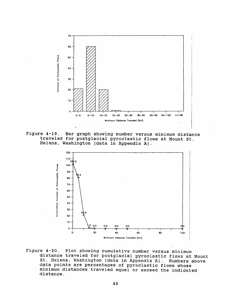
50 -
30 -
20 -:
0-5 5-10 10-15 15-20 20-30 30-4O 40-50 50-100 >-100
Minimum Distance Traveled 0<m)
Figure 4-19. Bar graph showing number versus minimum distance traveled for postglacial pyroclastic flows at Mount St. Helens, Washington (data in Appendix A).
120
0.0 0.0 r~
60 80 100
Minimum Distance Traveled
Figure 4-20. Plot showing cumulative number versus minimumdistance traveled for postglacial pyroclastic flows at Mount St. Helens, Washington (data in Appendix A). Numbers above data points are percentages of pyroclastic flows whose minimum distances traveled equal or exceed the indicated distance.
48
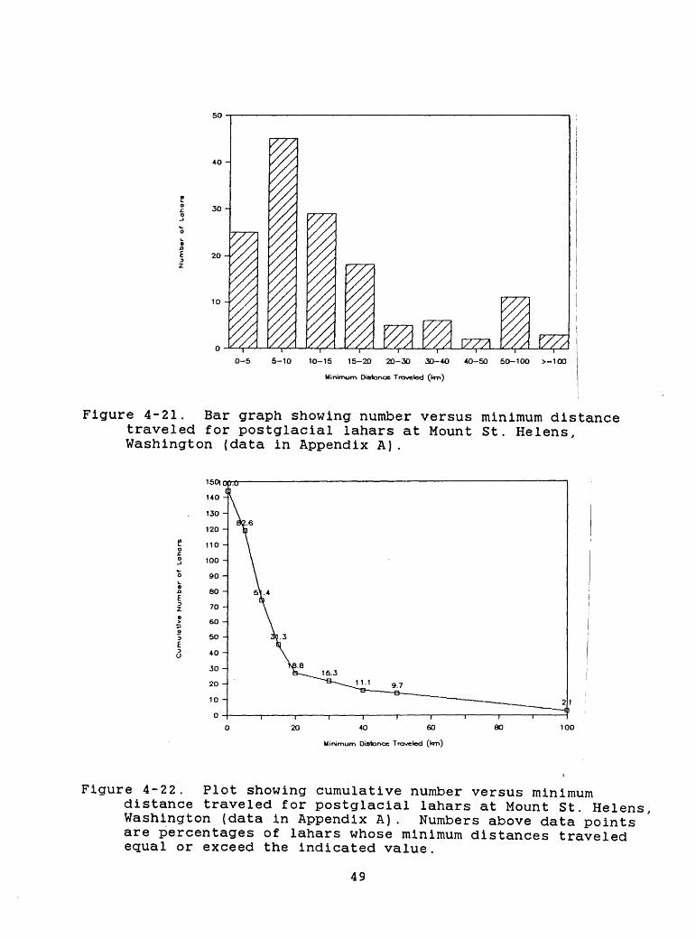
so
30 -
20
10 -
177710-5 5-10 10-15 15-20 20-30 30-40 40-50 50-100 >-100
Minimum Distonoe Traveled (t«m)
Figure 4-21. Bar graph showing number versus minimum distance traveled for postglacial lahars at Mount St. Helens, Washington (data in Appendix A).
20 40 6O
Minimum Distonoe Traveled (t«m)
Figure 4-22. Plot showing cumulative number versus minimumdistance traveled for postglacial lahars at Mount St. Helens, Washington (data in Appendix A). Numbers above data points are percentages of lahars whose minimum distances traveled equal or exceed the indicated value.
49
pyroclastic flows and lahars, extended far beyond the flanks of the volcano. Lava flows were produced mainly within the last 2500 yr; these affected areas chiefly within 10 km of the volcano, although two lava flows reached almost 20 km away (Figs. 4-23 and 4-24) .
The initial highly explosive activity of the present eruptive period, which began on May 18, 1980 following several months of small phreatic explosions, included a great debris avalanche and lateral blast that devastated areas in a broad sector 20-30 km north of the volcano (Christiansen and Peterson, 1981). Lahars reached the Columbia River by way of the Toutle and Cowlitz Rivers and obstructed the deep-water shipping channel. Smaller lahars were generated in all of the other drainages heading on the volcano. Tephra was deposited over a broad region east of the volcano, adversely affecting people as far away as eastern Montana. Pyroclastic flows extended northward as far as 7.5 km from the vent. Activity after May 18 included small explosive eruptions of tephra and pyroclastic flows, generation of lahars, and growth of a composite lava dome in the volcano's new crater.
4.6.2 Volcanic-hazards assessmentThe initial volcanic-hazards assessment for Mount St. Helens
(Crandell and others, 1975; Crandell and Mullineaux, 1978)--based on the eruptive events of the past 4500 yr--accurately anticipated the effects of most of the eruptions of the present eruptive period. Exceptions were the unprecedented magnitude (for Mount St. Helens) of the debris avalanche and lateral blast of May 18, 1980 (Miller and others, 1981). The events of May 18, which formed a large crater open to the north, drastically altered the form of the volcano. This prompted a revised hazard assessment (Miller and others, 1981), which pointed out the relatively greater hazard from flowage events and lateral explosions on the north flank of the volcano than in other sectors. Subsequently, Scott (1986) determined lahar-inundation frequencies for the Toutle-Cowlitz flood plains. In addition, Newhall (1982, 1984) developed a method for quantifying the risks to people in areas around the volcano from future eruptions.
Based on the past behavior of Mount St. Helens (Appendix A), the most likely events to occur during the course of the present eruptive period include dome building with related pyroclastic flows, minor tephra eruptions, and generation of lahars and floods. These events will chiefly affect areas along the valley of the North Fork Toutle River. Other likely events include extrusion of lava flows and explosive eruptions of tephra and related pyroclastic flows.
During past eruptive periods, such as the Kalama period of 500-350 yr ago (Hoblitt and others, 1980), the mean annual frequency of lahars and pyroclastic flows affecting areas within 10-20 km of the volcano increased greatly over the longer term
50
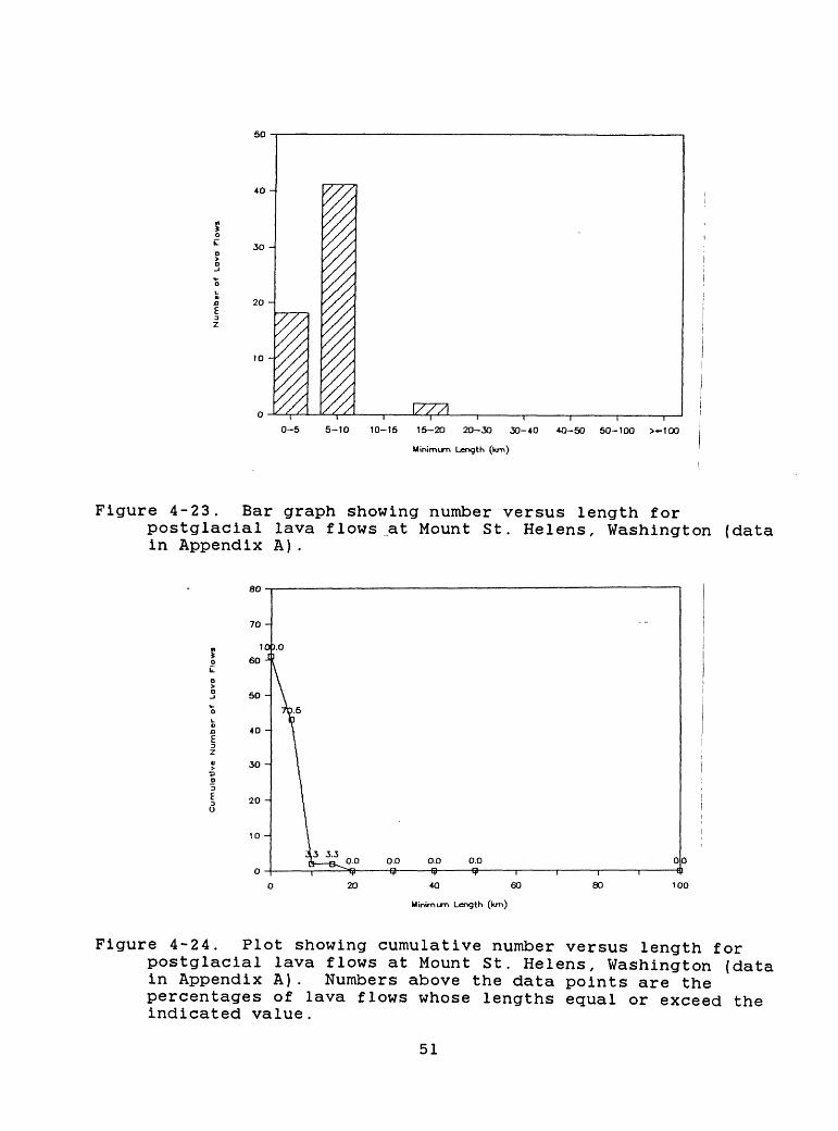
50
40 -
30 -
20 -
10 -
JZZZL , I , , |
0-5 5-10 10-15 15-20 20-30 30-40 40-50 50-100 >-100
Minimum Length (km)
Figure 4-23. Bar graph showing number versus length forpostglacial lava flows at Mount St. Helens, Washington (data in Appendix A).
0.0 0.0-9-
00 fl
40 60
Minimum Length (km)
80
Figure 4-24. Plot showing cumulative number versus length forpostglacial lava flows at Mount St. Helens, Washington (data in Appendix A). Numbers above the data points are the percentages of lava flows whose lengths equal or exceed the indicated value.
51
mean annual frequency, which included repose intervals as well as eruptive periods. Annual probabilities of such events estimated from the Kalama period (Appendix A) , which we infer are applicable to the present eruptive period, are more than 1 X 10" l .
Voluminous lahars, which occur less often, could affect areas far beyond a distance of 20 km. A recent study of the Toutle River valley (Scott, 1986) concludes that lahars or lahar-runout flows large enough to inundate flood plains 50 km or more from the volcano have an annual probability of at least 1 X 10" 2 . Generation of lahars in the Toutle River basin and erosion of deposits of the current eruptive period will continue to aggrade river channels and flood plains farther downstream and will increase flood peaks in the lower Toutle and Cowlitz River valleys and in the Columbia River near the mouth of the Cowlitz (U.S. Army Corps of Engineers, 1984).
In the near term (the next 1-10 yr), large explosive eruptions with widespread tephra fall and pyroclastic flows are less likely than continued dome building. The annual probability of a large (>0.1 km3 ) explosive eruption is about 1.5 X 10" 3 for the past 4500 yr and 8 X 10" 3 for the past 500 yr (Appendix A; Table 5-1). It should be noted that two large tephra-producing eruptions occurred just 2 yr apart, in 1480 and 1482 A.D., during the Kalama eruptive period (Yamaguchi, 1985). Voluminous tephra deposits would result from high eruption columns; tephra falling back onto the volcano from such columns would increase the likelihood of pyroclastic flows and lahars affecting all flanks of the volcano.
The Kalama and Lewis River valleys could also be affected by eruptions if the present dome continued to grow and eventually filled the crater. Pyroclastic flows from the upper part of the dome could then descend other flanks of the volcano. If such pyroclastic flows were as large as ones of the Swift Creek period, those on the south side could move down the valley of Swift Creek and enter Swift Creek Reservoir. Pyroclastic flows could also melt snow on and beyond the south flank of the volcano and generate lahars and floods that could reach the reservoir.
The Lewis River is dammed at three sites to form large reservoirs, which could be used to trap all but the very largest expectable floods and lahars provided they were drawn down in time (Crandell and Mullineaux, 1978). The flood effects of a failure of the Lewis River dams have been assessed for the Trojan Nuclear Plant (Portland General Electric, 1980), which lies on the west bank of the Columbia River across from the mouth of the Kalama River. That report concludes that the flood height at the plant site would be less than the design flood height.
4.7 Mount Hood
4.7.1 Eruptive historyMount Hood (Fig. 4-25) is a composite volcano of chiefly
andesite and dacite lava flows and pyroclastic debris (Wise, 1969). The cone is probably less than 730,000 yr old because of
52
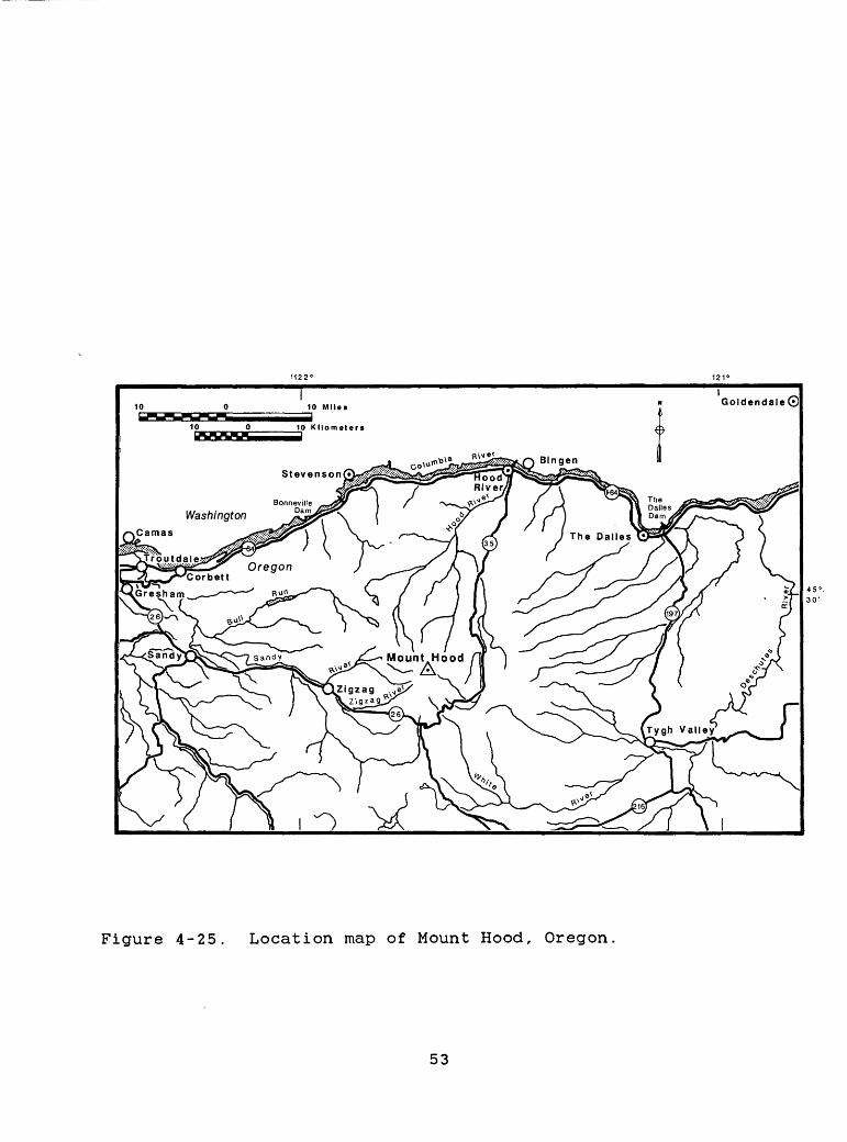
GoldendaleO
45° 30'
Figure 4-25. Location map of Mount Hood, Oregon.
53
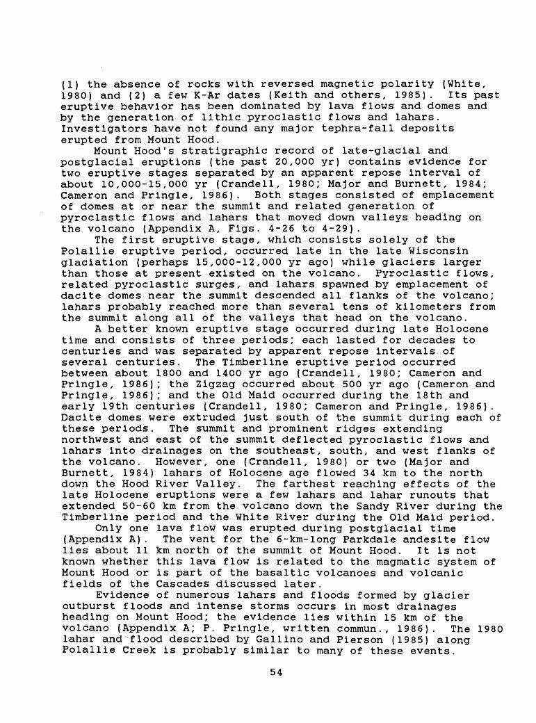
(1) the absence of rocks with reversed magnetic polarity (White, 1980) and (2) a few K-Ar dates (Keith and others, 1985). Its past eruptive behavior has been dominated by lava flows and domes and by the generation of lithic pyroclastic flows and lahars. Investigators have not found any major tephra-fall deposits erupted from Mount Hood.
Mount Hood's stratigraphic record of late-glacial and postglacial eruptions (the past 20,000 yr) contains evidence for two eruptive stages separated by an apparent repose interval of about 10,000-15,000 yr (Crandell, 1980; Major and Burnett, 1984; Cameron and Pringle, 1986). Both stages consisted of emplacement of domes at or near the summit and related generation of pyroclastic flows and lahars that moved down valleys heading on the volcano (Appendix A, Figs. 4-26 to 4-29).
The first eruptive stage, which consists solely of the Polallie eruptive period, occurred late in the late Wisconsin glaciation (perhaps 15,000-12,000 yr ago) while glaciers larger than those at present existed on the volcano. Pyroclastic flows, related pyroclastic surges, and lahars spawned by emplacement of dacite domes near the summit descended all flanks of the volcano; lahars probably reached more than several tens of kilometers from the summit along all of the valleys that head on the volcano.
A better known eruptive stage occurred during late Holocene time and consists of three periods; each lasted for decades to centuries and was separated by apparent repose intervals of several centuries. The Timberline eruptive period occurred between about 1800 and 1400 yr ago (Crandell, 1980; Cameron and Pringle, 1986); the Zigzag occurred about 500 yr ago (Cameron and Pringle, 1986); and the Old Maid occurred during the 18th and early 19th centuries (Crandell, 1980; Cameron and Pringle, 1986). Dacite domes were extruded just south of the summit during each of these periods. The summit and prominent ridges extending northwest and east of the summit deflected pyroclastic flows and lahars into drainages on the southeast, south, and west flanks of the volcano. However, one (Crandell, 1980) or two (Major and Burnett, 1984) lahars of Holocene age flowed 34 km to the north down the Hood River Valley. The farthest reaching effects of the late Holocene eruptions were a few lahars and lahar runouts that extended 50-60 km from the volcano down the Sandy River during the Timberline period and the White River during the Old Maid period.
Only one lava flow was erupted during postglacial time (Appendix A). The vent for the 6-km-long Parkdale andesite flow lies about 11 km north of the summit of Mount Hood. It is not known whether this lava flow is related to the magmatic system of Mount Hood or is part of the basaltic volcanoes and volcanic fields of the Cascades discussed later.
Evidence of numerous lahars and floods formed by glacier outburst floods and intense storms occurs in most drainages heading on Mount Hood; the evidence lies within 15 km of the volcano (Appendix A; P. Pringle, written commun., 1986). The 1980 lahar and flood described by Gallino and Pierson (1985) along Polallie Creek is probably similar to many of these events.
54
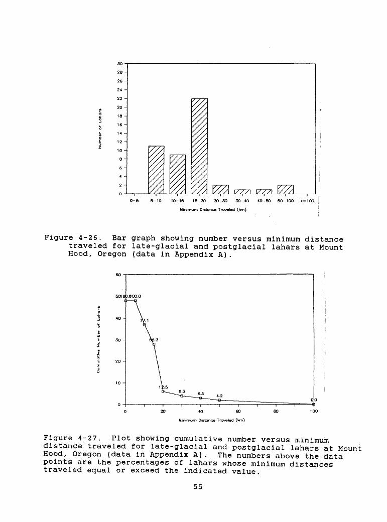
so -28 -
26 -
24 -
22 -
20 -
18 -
16 -
14 -
12 -
10 -
8 -
6 -
4 -
2 -
0 - \7~7~7\ I/XXI
0-5 5-10 10-15 15-20 20-30 30-40
Minimum Distance Traveled (km)
40-50 50-100 >-1OO
Figure 4-26. Bar graph showing number versus minimum distance traveled for late-glacial and postglacial lahars at Mount Hood, Oregon (data in Appendix A).
10 -
20 40 60
Minimum Distance Traveled (l<m)
80
Figure 4-27. Plot showing cumulative number versus minimum distance traveled for late-glacial and postglacial lahars at Mount Hood, Oregon (data in Appendix A). The numbers above the data points are the percentages of lahars whose minimum distances traveled equal or exceed the indicated value.
55
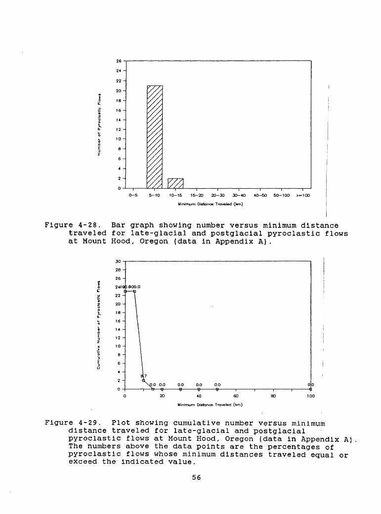
24 -
22 -
20 -
18 -
16 -
14 -
12 -
10 -
8 -
6 -
4 -
2 -
0-5 5-10 10-15 15-20 20-30 3O-4O 40-50 50-100 >-100
Minimum Distance Traveled (l<m)
Figure 4-28. Bar graph showing number versus minimum distancetraveled for late-glacial and postglacial pyroclastic flows at Mount Hood, Oregon (data in Appendix A).
0.0 0.0 0.0 00 f I
10040 6O
Minimum Distance Traveled (t<m)
80
Figure 4-29. Plot showing cumulative number versus minimum distance traveled for late-glacial and postglacial pyroclastic flows at Mount Hood, Oregon (data in Appendix A) The numbers above the data points are the percentages of pyroclastic flows whose minimum distances traveled equal or exceed the indicated value.
56
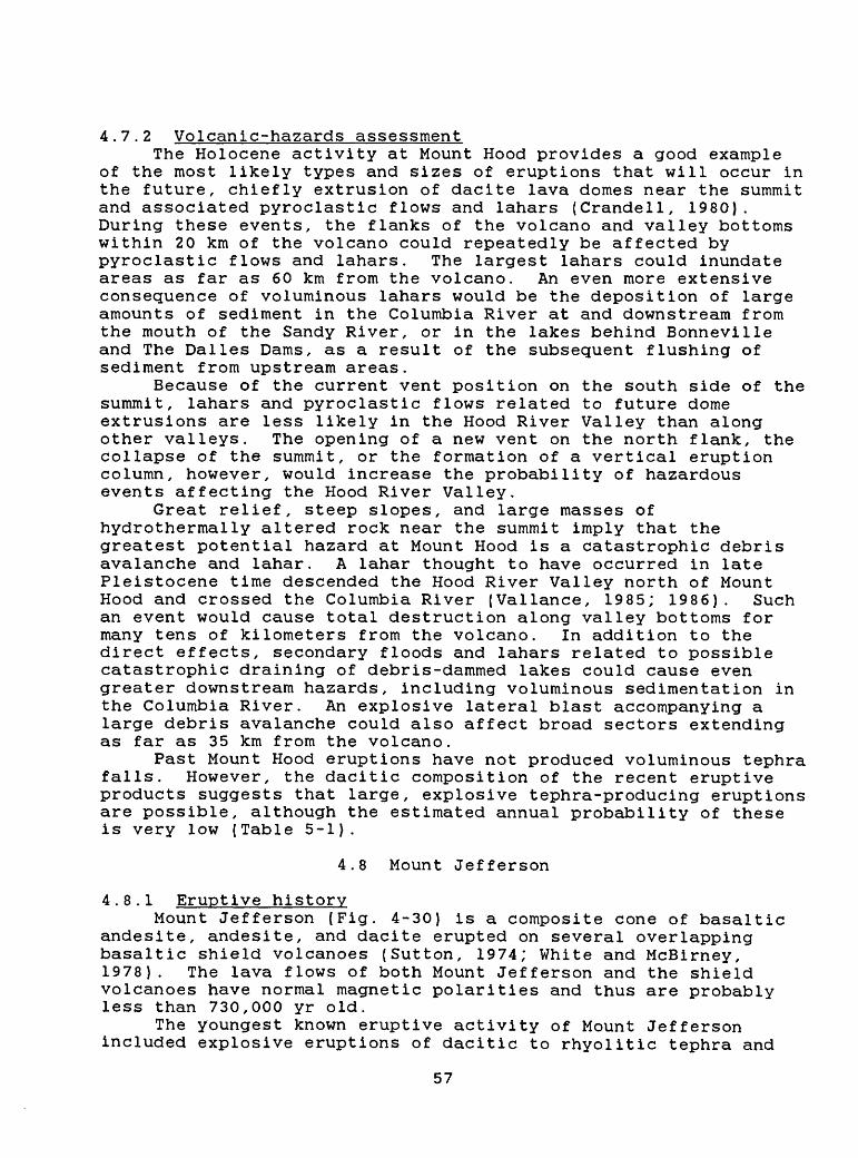
4.7.2 Volcanic-hazards assessmentThe Holocene activity at Mount Hood provides a good example
of the most likely types and sizes of eruptions that will occur in the future, chiefly extrusion of dacite lava domes near the summit and associated pyroclastic flows and lahars (Crandell, 1980). During these events, the flanks of the volcano and valley bottoms within 20 km of the volcano could repeatedly be affected by pyroclastic flows and lahars. The largest lahars could inundate areas as far as 60 km from the volcano. An even more extensive consequence of voluminous lahars would be the deposition of large amounts of sediment in the Columbia River at and downstream from the mouth of the Sandy River, or in the lakes behind Bonneville and The Dalles Dams, as a result of the subsequent flushing of sediment from upstream areas.
Because of the current vent position on the south side of the summit, lahars and pyroclastic flows related to future dome extrusions are less likely in the Hood River Valley than along other valleys. The opening of a new vent on the north flank, the collapse of the summit, or the formation of a vertical eruption column, however, would increase the probability of hazardous events affecting the Hood River Valley.
Great relief, steep slopes, and large masses of hydrothermally altered rock near the summit imply that the greatest potential hazard at Mount Hood is a catastrophic debris avalanche and lahar. A lahar thought to have occurred in late Pleistocene time descended the Hood River Valley north of Mount Hood and crossed the Columbia River (Vallance, 1985; 1986). Such an event would cause total destruction along valley bottoms for many tens of kilometers from the volcano. In addition to the direct effects, secondary floods and lahars related to possible catastrophic draining of debris-dammed lakes could cause even greater downstream hazards, including voluminous sedimentation in the Columbia River. An explosive lateral blast accompanying a large debris avalanche could also affect broad sectors extending as far as 35 km from the volcano.
Past Mount Hood eruptions have not produced voluminous tephra falls. However, the dacitic composition of the recent eruptive products suggests that large, explosive tephra-producing eruptions are possible, although the estimated annual probability of these is very low (Table 5-1).
4.8 Mount Jefferson
4.8.1 Eruptive historyMount Jefferson (Fig. 4-30) is a composite cone of basaltic
andesite, andesite, and dacite erupted on several overlapping basaltic shield volcanoes (Sutton, 1974; White and McBirney, 1978). The lava flows of both Mount Jefferson and the shield volcanoes have normal magnetic polarities and thus are probably less than 730,000 yr old.
The youngest known eruptive activity of Mount Jefferson included explosive eruptions of dacitic to rhyolitic tephra and
57
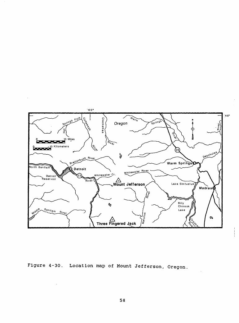
! 122'
AThree Fingered Jack
Figure 4-30. Location map of Mount Jefferson, Oregon
58
pyroclastic flows (Appendix A, Fig. 4-31) and the extrusion of lava domes (Beget, 1981; Yogodzinski and others, 1983). Relationship of the tephra to glacial deposits provides only broad minimum ages for this activity. The eruptions pre-date the late Wisconsin glaciation, which culminated between 22,000 and 18,000 yr ago, and probably also pre-date a glacial advance that occurred between 40,000 and 150,000 yr ago. Other evidence that bears on the age of the tephra comes from east-central Idaho. The lower of two tephra layers near Arco, Idaho, (Pierce, 1985) is chemically similar to the Jefferson tephra on the basis of preliminary work by A. M. Sarna-Wojcicki (written commun., 1986). The younger of the tephras near Arco has a fission-track age of 76,000 +/- 34,000 yr and is probably between 70,000 and 110,000 yr old (Pierce, 1985). The tephras occur in close stratigraphic succession in a loess deposit, which implies that the Jefferson-like tephra is not greatly older than the upper ash. This evidence suggests that if the Jefferson-like tephra near Arco and the Jefferson tephra described by Beget (1981) and Yogodzinski and others (1983) are equivalent, the Jefferson tephra is between 70,000 and 120,000 yr old.
The only known postglacial activity is small lahars and floods on the lower flanks of the volcano (Fig. 4-32), which probably resulted from non-eruptive processes. Postglacial eruptions at vents in an area south of Mount Jefferson produced scoria cones and lava flows. They are included in the discussion of the basaltic volcanoes and volcanic fields of the Cascades.
4.8.2 Volcanic-hazards assessmentThe hazard implications of Mount Jefferson's quiescence
during the past several tens of thousands of years is unclear. Is the volcano now in a long repose interval that will end with an explosive eruption, or are future eruptions unlikely? Owing to evidence of previous explosive eruptions, a conservative assessment would regard Mount Jefferson as a potentially explosive volcano. On the basis of currently available data, we estimate that the annual probability of a major explosive eruption is no more than 1 X 10" 5 . However, this value would be revised upward if future work determines that the behavior in the past few hundred thousand years has been characterized by short eruptive periods separated by repose intervals as long as the present one.
The great relief and steep slopes of the volcano imply a potential for voluminous debris avalanches and related lahars even in the absence of eruptions. Such events could affect valley floors 50 km or more away from the volcano. A more likely type of activity would be small debris avalanches and lahars, similar to those that occurred in postglacial time, which would chiefly affect valley bottoms within 10 km of the volcano.
59
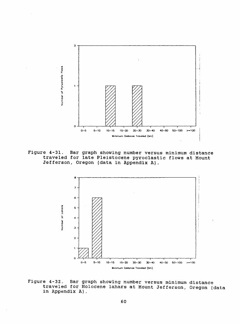
0-5 5-10 10-15 15-20 20-30 30-40
Minimum Distance Traveled 0<m)
I | r
40-50 50-100 >-1OO
Figure 4-31. Bar graph showing number versus minimum distance traveled for late Pleistocene pyroclastic flows at Mount Jefferson, Oregon (data in Appendix A).
7 -
5 -
4 -
3 -
//A0-5 5-10 10-15 15-20 20-30 30-40 40-50 50-100 >-1OO
Minimum Distance Traveled (l<m)
Figure 4-32. Bar graph showing number versus minimum distancetraveled for Holocene lahars at Mount Jefferson, Oregon (data in Appendix A).
60
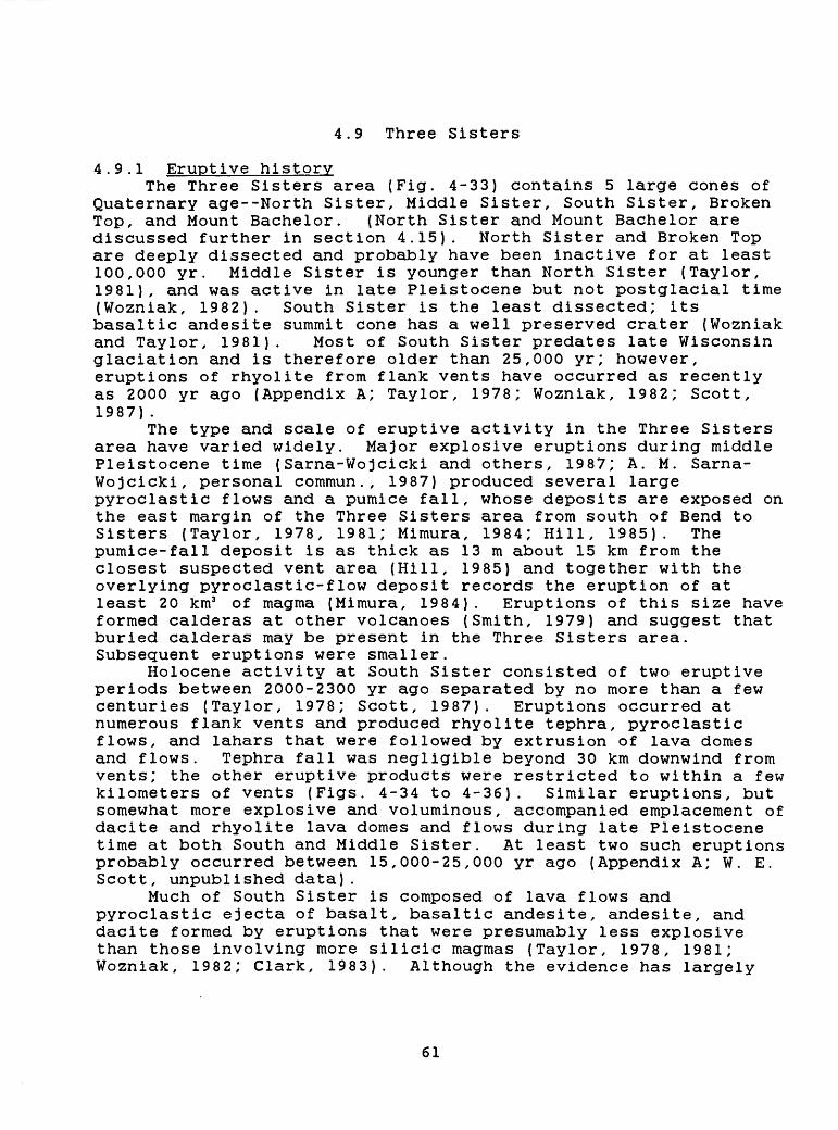
4.9 Three Sisters
4.9.1 Eruptive historyThe Three Sisters area (Fig. 4-33) contains 5 large cones of
Quaternary age--North Sister, Middle Sister, South Sister, Broken Top, and Mount Bachelor. (North Sister and Mount Bachelor are discussed further in section 4.15). North Sister and Broken Top are deeply dissected and probably have been inactive for at least 100,000 yr. Middle Sister is younger than North Sister (Taylor, 1981), and was active in late Pleistocene but not postglacial time (Wozniak, 1982). South Sister is the least dissected; its basaltic andesite summit cone has a well preserved crater (Wozniak and Taylor, 1981). Most of South Sister predates late Wisconsin glaciation and is therefore older than 25,000 yr; however, eruptions of rhyolite from flank vents have occurred as recently as 2000 yr ago (Appendix A; Taylor, 1978; Wozniak, 1982; Scott, 1987).
The type and scale of eruptive activity in the Three Sisters area have varied widely. Major explosive eruptions during middle Pleistocene time (Sarna-Wojcicki and others, 1987; A. M. Sarna- Wojcicki, personal commun., 1987) produced several large pyroclastic flows and a pumice fall, whose deposits are exposed on the east margin of the Three Sisters area from south of Bend to Sisters (Taylor, 1978, 1981; Mimura, 1984; Hill, 1985). The pumice-fall deposit is as thick as 13 m about 15 km from the closest suspected vent area (Hill, 1985) and together with the overlying pyroclastic-flow deposit records the eruption of at least 20 km3 of magma (Mimura, 1984). Eruptions of this size have formed calderas at other volcanoes (Smith, 1979) and suggest that buried calderas may be present in the Three Sisters area. Subsequent eruptions were smaller.
Holocene activity at South Sister consisted of two eruptive periods between 2000-2300 yr ago separated by no more than a few centuries (Taylor, 1978; Scott, 1987). Eruptions occurred at numerous flank vents and produced rhyolite tephra, pyroclastic flows, and lahars that were followed by extrusion of lava domes and flows. Tephra fall was negligible beyond 30 km downwind from vents; the other eruptive products were restricted to within a few kilometers of vents (Figs. 4-34 to 4-36). Similar eruptions, but somewhat more explosive and voluminous, accompanied emplacement of dacite and rhyolite lava domes and flows during late Pleistocene time at both South and Middle Sister. At least two such eruptions probably occurred between 15,000-25,000 yr ago (Appendix A; W. E. Scott, unpublished data).
Much of South Sister is composed of lava flows and pyroclastic ejecta of basalt, basaltic andesite, andesite, and dacite formed by eruptions that were presumably less explosive than those involving more silicic magmas (Taylor, 1978, 1981; Wozniak, 1982; Clark, 1983). Although the evidence has largely
61
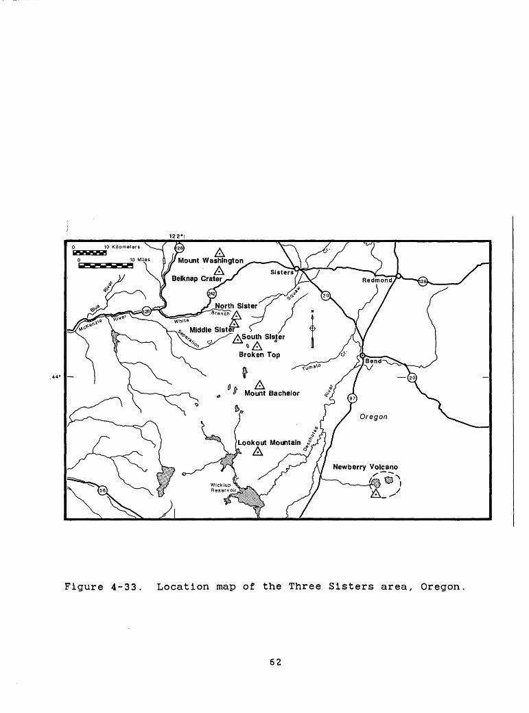
122"
Figure 4-33. Location map of the Three Sisters area, Oregon
62
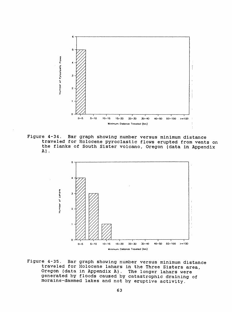
3 - .
2 -,
0-5
I
5-10 10-15 15-20 20-30 30-40
Minimum Distance Traveled 0<m)
4O-50 50-100 >-100
Figure 4-34. Bar graph showing number versus minimum distancetraveled for Holocene pyroclastic flows erupted from vents on the flanks of South Sister volcano, Oregon (data in Appendix A) .
3 -
I I I
40-50 50-100 >-1000-5 5-10 10-15 15-20 2O-30 30-40
Minimum Distance Traveled (km)
Figure 4-35. Bar graph showing number versus minimum distance traveled for Holocene lahars in the Three Sisters area, Oregon (data in Appendix A). The longer lahars were generated by floods caused by catastrophic draining of moraine-dammed lakes and not by eruptive activity.
63
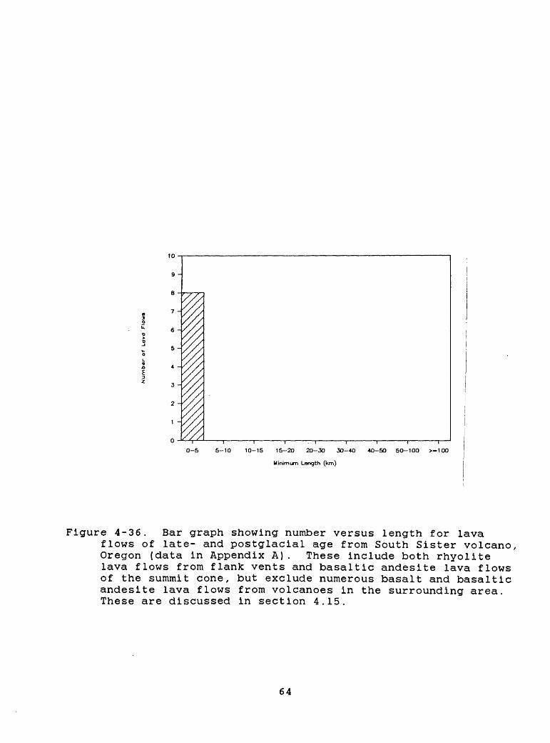
0-5 5-10 10-15 15-20 20-30 30-40 40-50 50-100 >-100
Minim im Length (km)
Figure 4-36. Bar graph showing number versus length for lavaflows of late- and postglacial age from South Sister volcano, Oregon (data in Appendix A). These include both rhyolite lava flows from flank vents and basaltic andesite lava flows of the summit cone, but exclude numerous basalt and basaltic andesite lava flows from volcanoes in the surrounding area. These are discussed in section 4.15.
64
been buried or eroded by glacial processes, Pleistocene eruptions at South Sister were probably accompanied by lahars and floods that affected areas many tens of kilometers downstream from the volcano.
4.9.2 Volcanic-hazards assessmentThe most likely type of future activity at South Sister is a
dacitic or rhyolitic eruption at one or more flank vents, similar to the eruptions of Holocene time. Areas within 10 km (Figs. 4- 34 to 4-36) of the volcano would be affected by tephra fall, pyroclastic flows, and lava flows and domes; thin (<1 cm) tephra might fall as far away as 30 km. A few dacitic and rhyolitic tephra-fall deposits of late Pleistocene age from vents on the flanks of South and Middle Sister are an order of magnitude thicker than the Holocene tephras at comparable distances from vents (Appendix A; W. E. Scott, unpublished data). This suggests that pyroclastic eruptions more voluminous and explosive than the Holocene eruptions are possible, although of much lower probability. Eruptions of basaltic andesite and andesite tephra and lava flows are also possible and would likewise affect areas chiefly within 10 km of vents. Because of the large volume of snow and ice on the volcano (Driedger and Kennard, 1984), any future eruption could generate lahars and floods, which might affect valley floors tens of kilometers from the volcano.
The least likely, but nevertheless possible, event in the Three Sisters area is a major explosive eruption of silicic magma like those of middle Pleistocene age. Such an eruption would affect areas tens of kilometers from vents with pyroclastic flows and areas to distances of hundreds of kilometers with thick tephra fall. Whether a silicic magma chamber of sufficient volume exists in the Three Sisters area to produce such an eruption is unclear. The distribution of late Pleistocene and Holocene vents of silicic and mafic magmas and the chemical composition of the magmas suggest a silicic magma chamber of several tens of cubic kilometers may be present (Scott, 1987). However, Bacon (1985) reasons that a shallow, silicic magma chamber of large volume (>50 km3 ) is probably not present based on vent distributions. Nevertheless, the Three Sisters area has had a long history of silicic eruptions and of explosive eruptions of large volume. Therefore, a conservative assessment would regard the Three Sisters area as a possible site for a future large-volume eruption.
65
4.10 Newberry volcano
4.10.1 Eruptive historyNewberry volcano (Fig. 4-37) lies 65 km east of the crest of
the Cascade Range and is one of the largest Quaternary volcanoes in the United States its broad shield-like shape covers more than 1300 km2 (MacLeod and others, 1981). A summit caldera 6-8 km across contains numerous rhyolite lava flows and domes and related pyroclastic debris; lava flows and tuffs of basalt and basaltic andesite are less common. The flanks of the volcano are composed of rhyolitic to andesitic pyroclastic-flow deposits, dacitic and rhyolitic lava flows and domes, and hundreds of scoria cones and lava flows of basalt and basaltic andesite (MacLeod and others, 1982). An active hydrothermal system is evidenced by warm springs in the caldera and by drilling that has penetrated zones with temperatures in excess of 265° C. at depths of 932 m (MacLeod and Sammel, 1982) .
Three Holocene rhyolitic eruptive episodes at vents within the caldera have produced one tephra-fall deposit that extends far to the east, several tephra-fall deposits of limited extent, a pyroclastic-flow and pyroclastic-surge deposit that is confined to the caldera, and numerous lava flows and domes (Appendix A,; MacLeod and others, 1981). Holocene activity at flank vents, some as far as 30 km from the caldera, was chiefly the formation of numerous scoria cones, local tephra-fall deposits, and lava flows of basalt and basaltic andesite (Appendix A, Fig. 4-38; Peterson and Groh, 1969; Chitwood and others, 1977; MacLeod and others, 1982). Rhyolitic eruptions of small volume may also have occurred on the upper flanks of the volcano (MacLeod and others, 1981).
The most voluminous eruptions of Newberry volcano occurred chiefly during middle Pleistocene time; however, one of these may have occurred as recently as several tens of thousands of years ago (MacLeod and others, 1981; MacLeod and Sammel, 1982). These eruptions produced voluminous tephra-fall and pyroclastic-flow deposits and were probably accompanied by caldera collapse. The sizes of these events are not well known, but the volume of one pyroclastic-flow deposit probably is more than 25 km3 (MacLeod and others, 1981) .
4.10.2 Volcanic-hazards assessmentThe past behavior of Newberry volcano suggests that the most
likely type of eruption in the future is a small- to moderate- volume (<0.1-1 km3 ) rhyolite eruption in the caldera or near the caldera rim. This activity probably would begin with the eruption of tephra and pyroclastic flows and surges and would culminate with the extrusion of lava domes or flows. Flowage phenomena would chiefly affect the caldera floor and areas within several
66
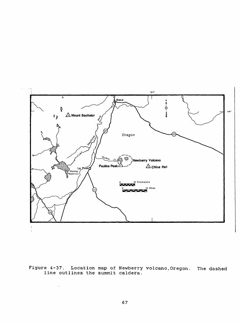
0 A, A Mount Bachelor -
Figure 4-37. Location map of Newberry volcano,Oregon line outlines the summit caldera.
The dashed
67
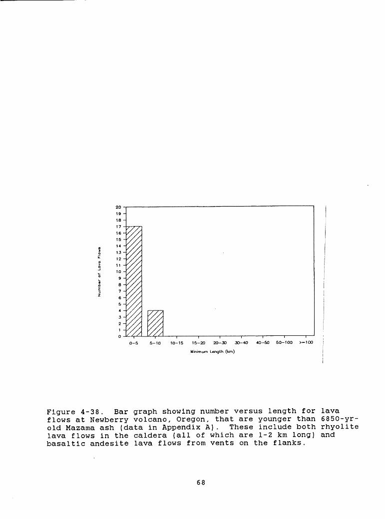
CO
0*
(-
O
H>
>T
JP
) P
) >
- >
-
H-
w <;
p. o
iQ
i-
S w
n
rt
n>
P)
CDH
- I-
N
P)
O
O
P) rt
**
S
3
'
3
CD
ood
H-
P)
£
CD
3
W
D
*W
3*
CDH
- rt
^
W
CD
CD d
*~1
P)!-
O
rt
<J
(Q
P)
P)
P)
O
*1<
>
- >-
- P)
P)
p.
!-»
r> *
rtCD
3 P)
jrM
> ^
^JI
P)
If
O
W
O
*O
x J3
*S3
*
O
OM
P)
CD
O
S
i-
1 3
n
H
-M
> !-
0
. CD
3
i-{
H-
VQ
VQ
00
X0
3
"*>
3
3
CD
13*
rt
D
*3
H
- £3
* CD
rt
O
P)
n
M
£3
* 1-
3 rt
D*
-^0
P)
CD
P)
CD
3 ^
W ^ ^
CD
CD
CD
COrt
C
3*
1
H* ^
MCD
1
3
OCM
O
C
I-
M>
(-
3
CDH
^
r»
^^
IJL^
^J
P)
3
P.
CD
(Q3
CD
^ rt
^* i
£TM
O
CT
rt
P
O
D
* n>
i£)
rt
P)
O**
* ^j
^
«j
P)
-{
o\
i-1
p tr
oo
P)p
. t<
^ tn
<^
OO
P)
I-1
1
rt
*~t
CD
1
c
o Oi
Oi J^
_o _^ o 1
- S
E
_
3:
f1
1
N"
5 O
5" R
1 1 -
X
IS
~
?-
S 6 i -
8 Oi o 1
_o
o V 1 0 o
Num
ber
of
Lava
F
low
s
__
.__
__
_._
_._
>ro
I I
I i
I i
i j
| I
I |
I i
i |
| I
I
$S
^M$S
^S§i
^^\>
OvvW
\\X
\\
~
kilometers of the rim. Depending on wind strength and the character of the eruption, significant tephra fall could occur many tens of kilometers from the caldera. The last rhyolitic tephra eruption at Newberry deposited 25 cm of tephra at a distance of 60 km (MacLeod and Sammel, 1982). The effects of Holocene lahars were apparently restricted to the caldera floor (MacLeod and others, 1982) . However, if explosive eruptions were to occur at vents in Paulina Lake, as they did in East Lake during Holocene time, floods and lahars could descend the lake's outlet stream, Paulina Creek, westward to the Little Deschutes River.
An eruption of basalt and basaltic andesite is also possible at Newberry volcano, either from a pre-existing or new vent on the flanks. Such an eruption would be less explosive than a rhyolitic eruption in the caldera; however, the resulting lava flows could be as long as 10 km and cover tens of square kilometers. Multiple eruptions of this type might occur over a relatively short period of time at vents arrayed along a system of fissures or faults that could extend as far as 30 km from the caldera. Such activity occurred about 6000 yr ago (MacLeod and others, 1981, 1982). An eruption of basalt and basaltic andesite could also occur in the caldera. During such eruptions in the past, interaction of magma with ground and surface waters caused violent explosions that resulted in generation of pyroclastic surges. The effects of such surges would probably be limited to within 15 km of vents.
A catastrophic silicic eruption of large volume (>10 km3 ) like those that have occurred very infrequently in the past is possible, but very unlikely. Such an eruption would produce pyroclastic flows and tephra fall that could devastate the flanks of the volcano and areas tens of kilometers beyond, and seriously affect areas many hundreds of kilometers downwind.
4.11 Crater Lake (Mount Mazama)
4.11.1 Eruptive historyCrater Lake (Fig. 4-39) occupies a caldera formed 6850 yr ago
during the climactic eruption of Mt. Mazama, which was a cluster of Pleistocene stratovolcanoes (Williams, 1942; Bacon, 1983; Druitt and Bacon, 1986) . A period of 15,000-40,000 yr was required to form the silicic component of the climactic magma chamber (Bacon, 1983). During that period, eruptions of basalt, andesite, dacite, and rhyolite occurred in the Mount Mazama area.
During the few centuries preceding the climactic eruption, at least two small- to moderate-volume (<1 to several cubic kilometers) eruptions of rhyolite occurred in the area underlain by the magma chamber (Appendix A; Bacon, 1983; C. R. Bacon, written commun., 1986). Tephra from one of these eruptions extended into southeastern Oregon and western Nevada (Davis, 1978, 1985; Blinman and others, 1979) and the same tephra, or one or more others, fell as far away as eastern Washington (Blinman and others, 1979; Mack and others, 1979). The explosive eruptions were followed by the extrusion of rhyolite lava flows.
The climactic eruptions 6850 yr ago produced voluminous
69
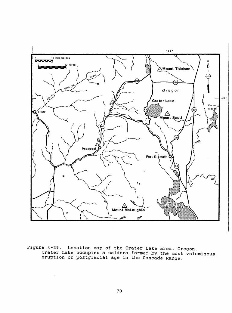
122'
Oregon
Crater Lake | 43"
Figure 4-39. Location map of the Crater Lake area, Oregon.Crater Lake occupies a caldera formed by the most voluminous eruption of postglacial age in the Cascade Range.
70
tephra-fall and pyroclastic-flow deposits. The tephra deposits are about 40 cm thick at points 200 km northeast of the volcano and 4-5 cm thick at 1000 km (Fig. 3-1); layers have been found in 8 western states and 3 Canadian provinces. The tephra fall was followed by two episodes of pyroclastic-flow formation. The first was of small extent, but it was followed by voluminous pyroclastic flows that moved outward in all directions to distances of as much as 60 km (Fig. 4-40; Bacon, 1983). The total volume of magma erupted during the climactic eruption was about 50-60 km3 (Bacon, 1983) , which is an order of magnitude larger than that produced during any other explosive eruption in the Cascade Range during postglacial time.
Following the climactic eruption, an andesite scoria cone and lava flows were erupted within the caldera to form Wizard Island (Appendix A; Fig. 4-41; Bacon, 1983; C. R. Bacon, written commun., 1986). The initial postcaldera eruptions probably occurred shortly after the climactic eruption, prior to the development of the lake. Other eruptions occurred after the lake had begun to form. A rhyolite dome on the flank of the Wizard Island volcano records the youngest known eruptive activity.
4.11.2 Volcanic-hazards assessmentA comprehensive assessment of potential volcanic hazards at
Crater Lake is premature and can only be attempted when the current state of the magma chamber is better known. A critical question is whether sufficient silicic magma is now present or will be present in the near future to sustain an eruption similar to that of 6850 yr ago. One line of reasoning suggests that another such eruption may not occur for thousands of years, because 15,000-40,000 yr were required for the climactic magma chamber to evolve. This reasoning is consistent with Smith's (1979) estimate of the periodicity of large-volume (lO 1 -!© 2 km3 ) eruptions at other volcanoes. However, it is not known that these estimates are applicable to the existing magmatic system of Crater Lake. Is the present magma chamber in such a state now that the most likely events are small- to moderate-volume eruptions (10~ 2 to 10 1 km3 ) of andesite, dacite, and rhyolite? If so, what is the probability of such eruptions over the next 50-100 yr? These questions cannot yet be answered. We use an annual probability of 2 X 10"* for explosive eruptions exceeding 0.1 km3 in the tephra- hazard assessment in Chapter 5 (Table 5-1). This estimate is based on the frequency of such eruptions at Mount Mazama in postglacial time (Appendix A). However, during this time period the magma chamber underwent major changes. Thus this estimate has a high degree of uncertainty.
Small- to moderate-volume eruptions of andesite, dacite, or rhyolite within the caldera could produce waves in the lake, pyroclastic flows and surges, and lava flows and domes whose major
71
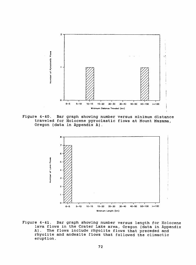
T i " "I ' ' i0-5 5-10 10-15 15-20 20-30 30-4O 4O-50 50-100 >-100
Minimum Distance Traveled (km)
Figure 4-40. Bar graph showing number versus minimum distance traveled for Holocene pyroclastic flows at Mount Mazama, Oregon (data in Appendix A).
5 -
2 -
0-5 5-10 10-15 15-20 20-30 30-4O 4O-50 50-100 >-100
Minim trn Length (km)
Figure 4-41. Bar graph showing number versus length for Holocene lava flows in the Crater Lake area, Oregon (data in Appendix A). The flows include rhyolite flows that preceded and rhyolite and andesite flows that followed the climactic eruption.
72
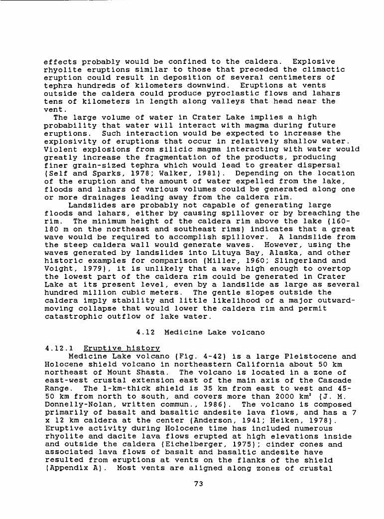
effects probably would be confined to the caldera. Explosive rhyolite eruptions similar to those that preceded the climactic eruption could result in deposition of several centimeters of tephra hundreds of kilometers downwind. Eruptions at vents outside the caldera could produce pyroclastic flows and lahars tens of kilometers in length along valleys that head near the vent.
The large volume of water in Crater Lake implies a high probability that water will interact with magma during future eruptions. Such interaction would be expected to increase the explosivity of eruptions that occur in relatively shallow water. Violent explosions from silicic magma interacting with water would greatly increase the fragmentation of the products, producing finer grain-sized tephra which would lead to greater dispersal (Self and Sparks, 1978; Walker, 1981). Depending on the location of the eruption and the amount of water expelled from the lake, floods and lahars of various volumes could be generated along one or more drainages leading away from the caldera rim.
Landslides are probably not capable of generating large floods and lahars, either by causing spillover or by breaching the rim. The minimum height of the caldera rim above the lake (160- 180 m on the northeast and southeast rims) indicates that a great wave would be required to accomplish spillover. A landslide from the steep caldera wall would generate waves. However, using the waves generated by landslides into Lituya Bay, Alaska, and other historic examples for comparison (Miller, 1960; Slingerland and Voight, 1979), it is unlikely that a wave high enough to overtop the lowest part of the caldera rim could be generated in Crater Lake at its present level, even by a landslide as large as several hundred million cubic meters. The gentle slopes outside the caldera imply stability and little likelihood of a major outward- moving collapse that would lower the caldera rim and permit catastrophic outflow of lake water.
4.12 Medicine Lake volcano
4.12.1 Eruptive historyMedicine Lake volcano (Fig. 4-42) is a large Pleistocene and
Holocene shield volcano in northeastern California about 50 km northeast of Mount Shasta. The volcano is located in a zone of east-west crustal extension east of the main axis of the Cascade Range. The 1-km-thick shield is 35 km from east to west and 45- 50 km from north to south, and covers more than 2000 km2 (J. M. Donnelly-Nolan, written commun., 1986). The volcano is composed primarily of basalt and basaltic andesite lava flows, and has a 7 x 12 km caldera at the center (Anderson, 1941; Heiken, 1978). Eruptive activity during Holocene time has included numerous rhyolite and dacite lava flows erupted at high elevations inside and outside the caldera (Eichelberger, 1975); cinder cones and associated lava flows of basalt and basaltic andesite have resulted from eruptions at vents on the flanks of the shield (Appendix A). Most vents are aligned along zones of crustal
73
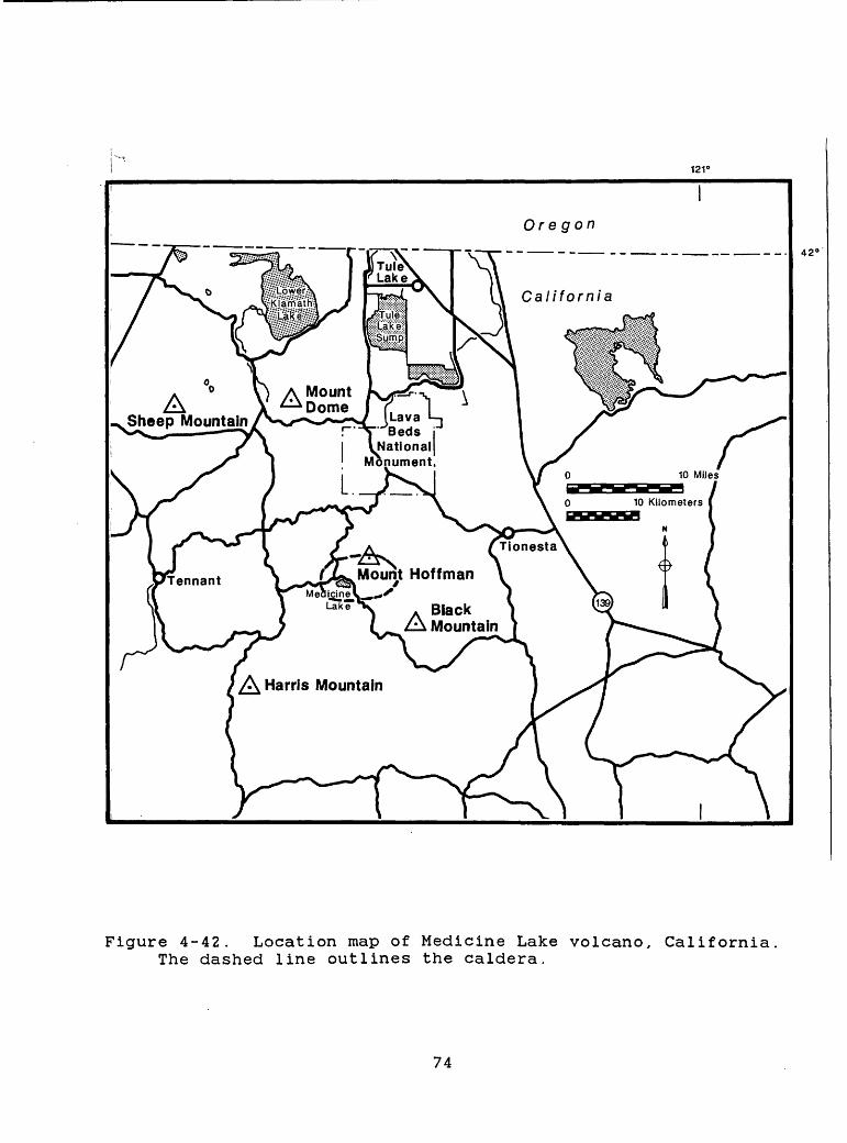
121°
Oregon
ASheep Mountain Lava
Beds National
Monument.
42 «
Figure 4-42. Location map of Medicine Lake volcano, California The dashed line outlines the caldera.
74
weakness that trend NNE to NNW.Basalt or basaltic andesite was erupted from at least eight
vents on the flanks of the Medicine Lake volcano about 10,000 yr ago (J. M. Donnelly-Nolan and D. E. Champion, written commun., 1986). These eruptions produced accumulations of cinders near and downwind from vents, and lava flows a few kilometers to about 45 km in length (Figs. 4-43, 4-44). Explosions several thousand years ago formed several craters near the southeast caldera rim. Scoriaceous andesitic tephra erupted from these craters lies mostly within a few kilometers of the vents and has a volume of about 0.01 km3 (J. M. Donnelly-Nolan, written commun., 1986). Within the past 2000 yr, eruptions of mafic or silicic magma occurred at more than a dozen vents on Medicine Lake volcano. Basalt to basaltic andesite tephra and lava flows were erupted at three main centers on the north, west, and south flanks. These lava flows range from a few hundred meters to about 7 km in length (Figs. 4-43 and 4-44; J. M. Donnelly-Nolan, written commun., 1986). In addition, four main eruptive centers, two with many individual vents, erupted dacite, rhyolite, or mixed magmas. Most of the silicic eruptions began explosively and produced pumiceous tephras with volumes of less than 0.1 km3 , some of which extend downwind for several tens of kilometers (Heiken, 1978). Silicic lava flows and (or) domes formed during late activity at each vent.
About 1100 to 900 yr ago, eruptions of mafic and silicic magma occurred in rapid succession (J. M. Donnelly-Nolan and D. E. Champion, written commun., 1986; C. D. Miller, unpublished data). Most active vents during this period are aligned along north- northwest to north-northeast trending faults or zones of extension and were fed by dikes (Fink and Pollard, 1983) .
No pyroclastic flows of Holocene age have been found in the Medicine lake region, although explosive eruptions of rhyolite of similar composition and volume at volcanoes in the Three Sisters and Inyo Craters areas of Oregon and California, respectively, produced small pyroclastic flows that traveled several kilometers from their vents (Miller, 1984; Scott, 1987).
At least two eruptions, with volumes of at least several cubic kilometers, occurred at Medicine Lake volcano during the last 1 million years (J. M. Donnelly-Nolan, unpublished data, in Christiansen, 1982). One of these is represented by a rhyolitic- dacitic ash-flow tuff north of the volcano which is probably older than about 730,000 yr (D. E. Champion, unpublished data, in Christiansen, 1982). The other is recorded by an andesitic ash- flow tuff either about 130,000 yr old, or about 60,000 to 70,000 yr old (Donnelly-Nolan and Nolan, 1986), which is found on the flanks of the shield as far as 25 km from its presumed source within the caldera (J. M. Donnelly-Nolan, written commun., 1986).
75
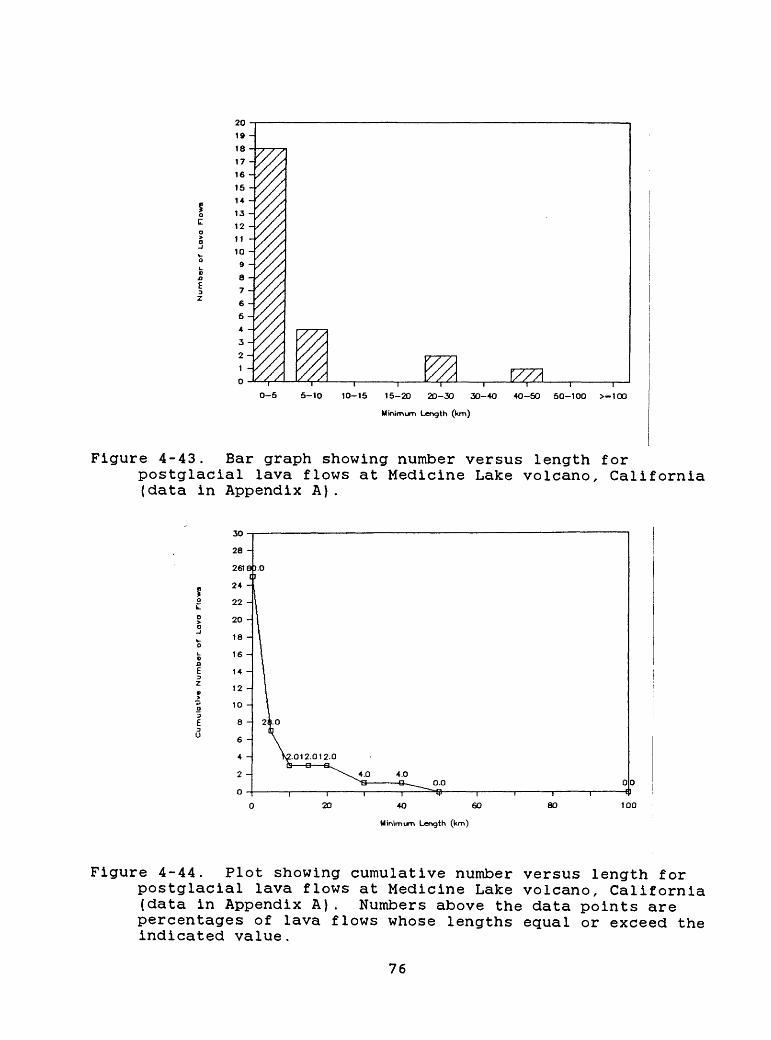
0-5 5-10 10-15 15-20 20-30 30-40 40-50 50-100 >-1OO
Minimim Lervgth (km)
Figure 4-43. Bar graph showing number versus length forpostglacial lava flows at Medicine Lake volcano, California (data in Appendix A).
40 60
Minimim Lervgth (km)
80 100
Figure 4-44. Plot showing cumulative number versus length forpostglacial lava flows at Medicine Lake volcano, California (data in Appendix A). Numbers above the data points are percentages of lava flows whose lengths equal or exceed the indicated value.
76
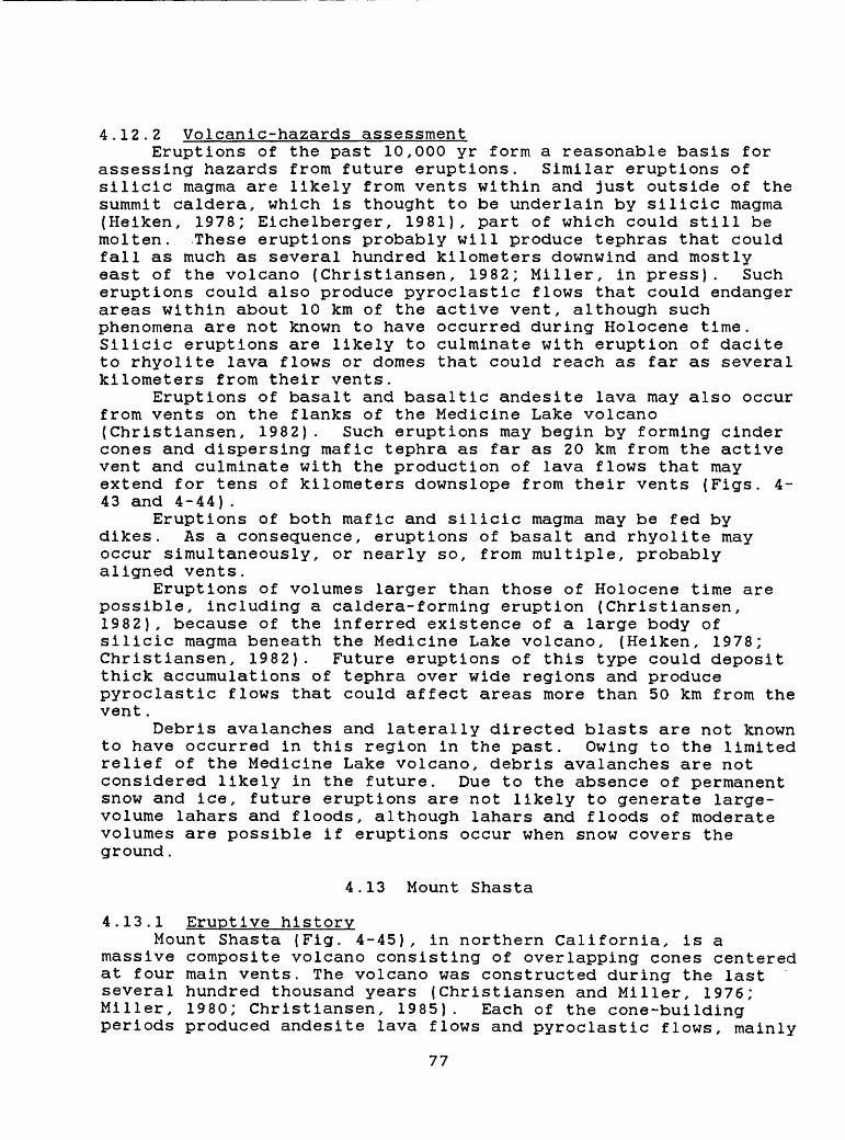
4.12.2 Volcanic-hazards assessmentEruptions of the past 10,000 yr form a reasonable basis for
assessing hazards from future eruptions. Similar eruptions of silicic magma are likely from vents within and just outside of the summit caldera, which is thought to be underlain by silicic magma (Heiken, 1978; Eichelberger, 1981), part of which could still be molten. These eruptions probably will produce tephras that could fall as much as several hundred kilometers downwind and mostly east of the volcano {Christiansen, 1982; Miller, in press). Such eruptions could also produce pyroclastic flows that could endanger areas within about 10 km of the active vent, although such phenomena are not known to have occurred during Holocene time. Silicic eruptions are likely to culminate with eruption of dacite to rhyolite lava flows or domes that could reach as far as several kilometers from their vents.
Eruptions of basalt and basaltic andesite lava may also occur from vents on the flanks of the Medicine Lake volcano {Christiansen, 1982). Such eruptions may begin by forming cinder cones and dispersing mafic tephra as far as 20 km from the active vent and culminate with the production of lava flows that may extend for tens of kilometers downslope from their vents (Figs. 4- 43 and 4-44).
Eruptions of both mafic and silicic magma may be fed by dikes. As a consequence, eruptions of basalt and rhyolite may occur simultaneously, or nearly so, from multiple, probably aligned vents.
Eruptions of volumes larger than those of Holocene time are possible, including a caldera-forming eruption (Christiansen, 1982), because of the inferred existence of a large body of silicic magma beneath the Medicine Lake volcano, (Heiken, 1978; Christiansen, 1982). Future eruptions of this type could deposit thick accumulations of tephra over wide regions and produce pyroclastic flows that could affect areas more than 50 km from the vent.
Debris avalanches and laterally directed blasts are not known to have occurred in this region in the past. Owing to the limited relief of the Medicine Lake volcano, debris avalanches are not considered likely in the future. Due to the absence of permanent snow and ice, future eruptions are not likely to generate large- volume lahars and floods, although lahars and floods of moderate volumes are possible if eruptions occur when snow covers the ground.
4.13 Mount Shasta
4.13.1 Eruptive historyMount Shasta (Fig. 4-45), in northern California, is a
massive composite volcano consisting of overlapping cones centered at four main vents. The volcano was constructed during the last several hundred thousand years (Christiansen and Miller, 1976; Miller, 1980; Christiansen, 1985). Each of the cone-building periods produced andesite lava flows and pyroclastic flows, mainly
77
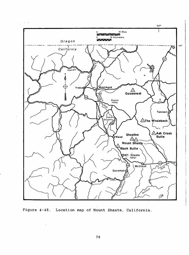
10 Miles
10 Kilometers
Oregon
California
AGoosenest
Tennant
Alhe Whaleback
Weed
Mount Shasta >Black Butte v ^
MT. Shasta \
«^N/
Figure 4-45. Location map of Mount Shasta, California.
78
at the central vents, as well as numerous lahars on and beyond the flanks of the volcano. Construction of each cone was followed by eruption of domes and pyroclastic flows of more silicic composition at central vents, and of domes, cinder cones, and lava flows at vents on the flanks of the cones.
Two of the main eruptive centers at Mount Shasta, the Shastina and Hotlum (summit of Mount Shasta) cones (Fig. 4-45), were formed during the last 10,000 yr (Miller, 1980). Holocene eruptions also occurred at Black Butte, a composite dacite dome about 13 km west of Mount Shasta (Miller, 1978; Fig. 4-45). Geologically recent eruptions at these two main centers and at flank vents (Appendix A) form the principal basis for assessing the most likely kinds of future eruptive activity and associated potential hazards.
Streams that head on Mount Shasta drain into the Shasta River to the northwest, the Sacramento River to the west and southwest, and the McCloud River to the east, southeast, and south (Fig. 4- 45). The lower flanks of Mount Shasta consist mostly of broad, smooth coalescent fans formed by pyroclastic flows, lahars, and streams that descended the volcano along canyons and then spread out. As a result, pyroclastic flows and lahars at Mount Shasta have traveled a shorter distance from the volcano than they would have if they had been confined to narrow valleys. Their paths, on the fans, however, are less predictable.
Mount Shasta has erupted on the average at least once per 800 yr during the past 10,000 yr, about once per 300 yr during the past 3,500 yr, and about once per 250 yr during the past 750 yr (Miller, 1980; Crandell and others, 1984). The last known eruption occurred about 200 radiocarbon years ago (Miller, 1980) and may have occurred in 1786 A.D. (Finch, 1930).
Eruptions during the last 10,000 yr produced lava flows and domes on and around the flanks of Mount Shasta. Lava flows issued from vents near the summit and from flank vents as far as 9 km away, and individual flows are as long as 13 km. Only about 33 percent of past lava flows reached more than 10 km from the summit and none reached as far as 20 km (Figs. 4-46 and 4-47).
Some pyroclastic flows originating at the summit vent and at the Shastina vent extended more than 20 km (Figs. 4-48 and 4-49; Miller, 1978; Miller, 1980). Pyroclastic flows from the Black Butte vent extended about 10 km southwestward.
Eruptions at the Hotlum and Shastina vents produced many lahars, about 20 percent of which reached more than 20 km from the summit of Mount Shasta (Figs. 4-50 and 4-51), and spread out on fans around the base of the volcano. Even larger lahars and floods extended beyond the base of the volcano and entered the McCloud and Sacramento Rivers (Hill and Egenhoff, 1976; Miller, 1980).
79
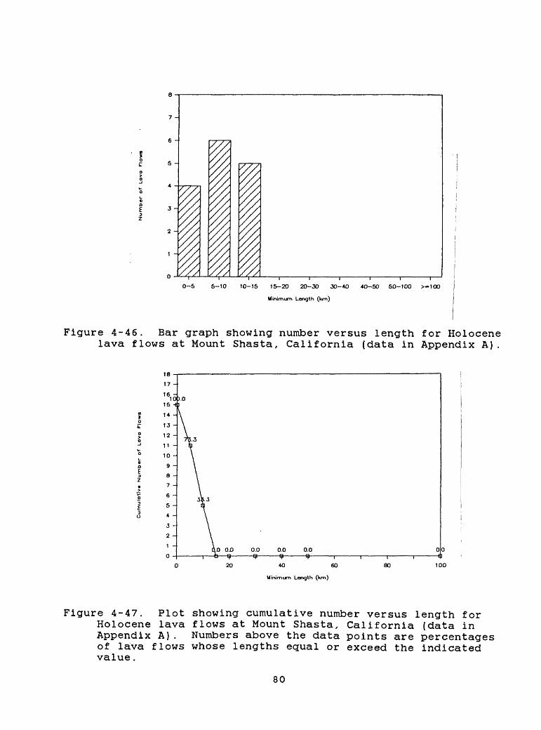
0-5 5-10 10-15 15-20 20-30 30-4O 4O-50 50-100 >-100
Minimum Length (km)
Figure 4-46. Bar graph showing number versus length for Holocene lava flows at Mount Shasta, California (data in Appendix A).
0.0 0.0 0.0
4O 60
Minimum Length (km)
80 100
Figure 4-47. Plot showing cumulative number versus length for Holocene lava flows at Mount Shasta, California (data in Appendix A). Numbers above the data points are percentages of lava flows whose lengths equal or exceed the indicated value.
80
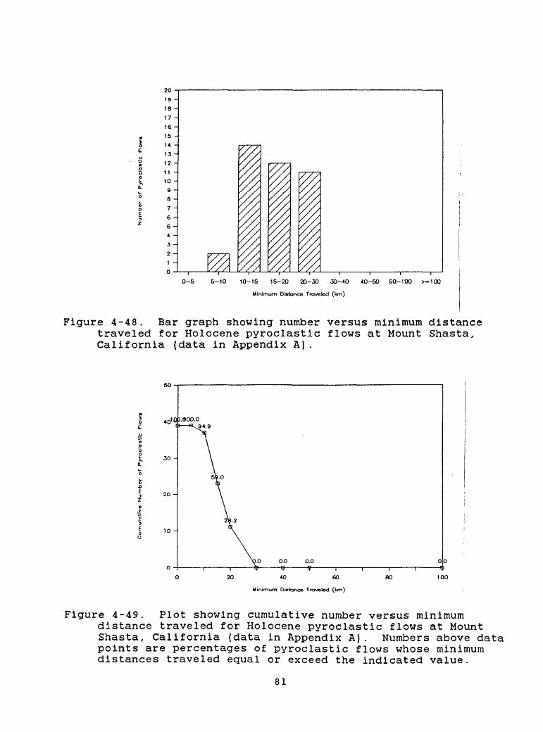
20 -
19 -
18 -
17 -
16 -
15 -
14 -
13 -
12 -
11 -
10 -
9 -
8 -
7 -
6 -
5 -
4 -
3 -
1 -
0 -
0-5 5-10 10-15 15-20 20-30 30-40
Minimum Distance Traveled (l<rn)
40-50 50-100 >-100
Figure 4-48. Bar graph showing number versus minimum distance traveled for Holocene pyroclastic flows at Mount Shasta, California (data in Appendix A).
0.0 0.0
40 60
Minimum Distance Traveled (l<m)
80
00 ei 100
Figure 4-49. Plot showing cumulative number versus minimumdistance traveled for Holocene pyroclastic flows at Mount Shasta, California (data in Appendix A). Numbers above data points are percentages of pyroclastic flows whose minimum distances traveled equal or exceed the indicated value.
81
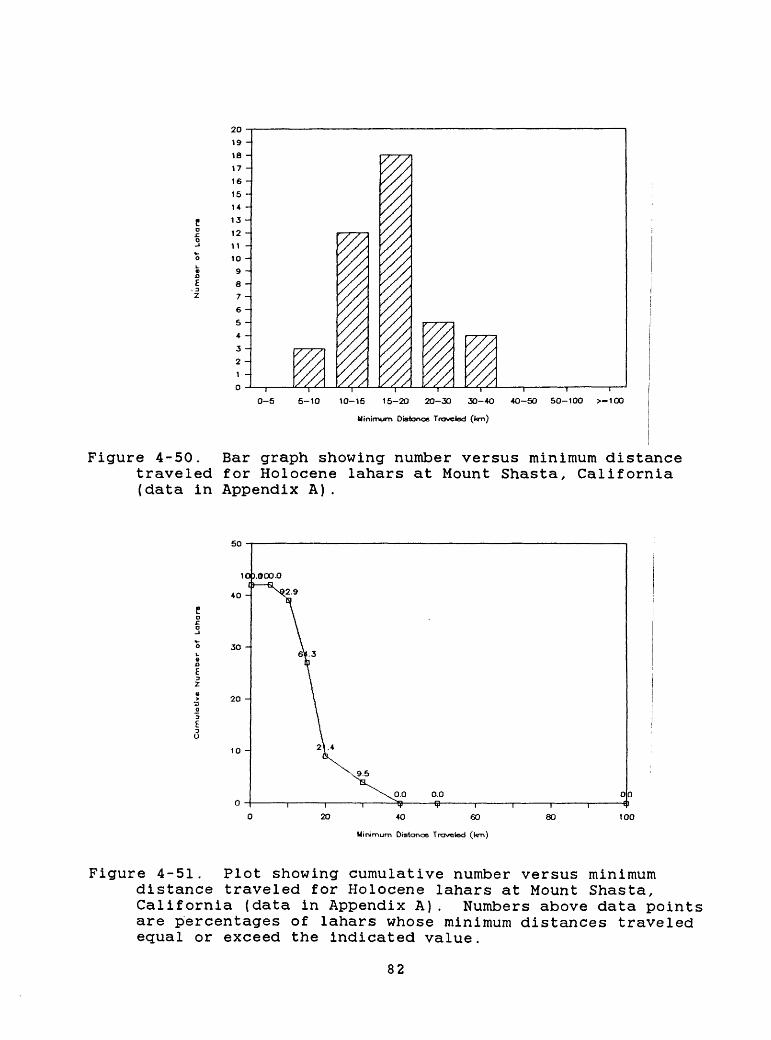
2019 -J
18 -
17 -
16 -
15 -
14 -
13 -
12 -
11 -
10 -
9 -
8 *
7 -
6 -
5 -
4 -
3 -
2 -
1 -
0
0-5 5-10 10-15 15-2O 20-30 30-4O 4O-50 50-100 >-100
Minimum Distance Traveled (km)
Figure 4-50. Bar graph showing number versus minimum distance traveled for Holocene lahars at Mount Shasta, California (data in Appendix A).
50
10).000.0
40 H
30 -
20 -
0.0
40 60
Minimum Distonoe Traveled (km)
100
Figure 4-51. Plot showing cumulative number versus minimum distance traveled for Holocene lahars at Mount Shasta, California (data in Appendix A). Numbers above data points are percentages of lahars whose minimum distances traveled equal or exceed the indicated value.
82
During Holocene time Mount Shasta erupted pumiceous dacite tephra twice about 10,000 yr ago (Miller, 1980). One deposit is more than 0.1 km3 in volume and the other is less than 0.1 km3 ; both lie mainly east and within about 50 km of the volcano. Lithic ash has been erupted at Mount Shasta many times during the last 10,000 yr and the deposits mantle the ground surface within about 25 km of the summit (Miller, 1980).
No known debris avalanches have occurred at Mount Shasta during Holocene time, but a catastrophic debris avalanche occurred at there between about 300,000 and 360,000 yr ago (Crandell and others, 1984; Ui and Glicken, 1986). According to D. R. Crandell (personal commun., 1986), the Shasta debris avalanche flowed more than 64 km through the Shasta valley, covers more than 675 km2 , and has a volume that exceeds 45 km3 .
4.13.2 Volcanic-hazards assessmentFuture eruptions like those of the last 10,000 yr will
probably produce deposits of lithic ash, lava flows, domes, and pyroclastic flows, and could endanger works of man that lie within several tens of kilometers of the volcano.
Lava flows and pyroclastic flows may affect low areas within about 15-20 km of the summit of Mount Shasta or any satellite vent that might become active (Figs. 4-46 to 4-49). Lahars could affect valley floors and other low areas as much as several tens of kilometers from Mount Shasta (Figs. 4-50 and 4-51).
Owing to great relief and steep slopes, a portion of the volcano could also fail catastrophically and generate a very large debris avalanche and lahar. Such events could affect any sector around the volcano and could reach more than 50 km from the summit. Explosive lateral blasts could also occur as a result of renewed eruptive activity, or they could be associated with a large debris avalanche; such events could affect broad sectors to a distance of more than 30 km from the volcano.
On the basis of its Holocene behavior, the probability is low that Mount Shasta will erupt large volumes of pumiceous ash in the future. The distribution of Holocene tephra and prevailing wind directions suggest that areas most likely to be affected by tephra are mainly east and within about 50 km of the summit of the volcano. However, the andesitic and dacitic composition of its products suggests that Mount Shasta could erupt considerably larger volumes of tephra in the future. Moreover, Christiansen (1982) has suggested that because it is a long-lived volcanic center and has erupted only relatively small volumes of magma for several thousand years, Mount Shasta is the most likely Cascade Range volcano to produce an explosive eruption of very large volume (10 l -10 2 ) km3 . Such an event could produce tephra deposits as extensive and as thick as the Mazama ash (Fig. 3-1) and pyroclastic flows that could reach more than 50 km from the vent. The annual probability for such a large event may be no greater than 10" 5 , but it is finite.
83
4.14 Lassen volcanic center
4.14.1 Eruptive historyThe Lassen volcanic center consists of a chain of vents aligned roughly north-south that extends about 8 km north from Lassen Peak (Fig. 4-52). Although volcanism began at the center between about 600,000 and 350,000 yr ago (Clynne, 1984), events of the last 35,000 yr (Appendix A) are the most thoroughly studied and form the basis for assessing hazards from future eruptions in the region.
The stratigraphic record of late Pleistocene and Holocene eruptions in this region contains evidence for many episodes of eruptive activity during the last 35,000 yr (Day and Alien, 1925; Crandell and Mullineaux, 1970; Crandell and others, 1974; Heiken and Eichelberger, 1980; Christiansen and Clynne, 1986; Clynne and Christiansen, 1987). Eruptions about 35,000 yr ago (Trimble and others, 1984; M. A. Clynne, written commun., 1986) produced two pyroclastic flows from a vent east of Sunflower Flat near the north end of the chain. These eruptions were followed by extrusion of one or more domes at vents in the same area.
Eruptions at Hat Mountain about 25,000-35,000 yr ago (M. A. Clynne, written commun., 1986) produced andesitic lava flows that reached up to 6 km from their vents (Appendix A). At about the same time, eruptions at a vent now buried by the Lassen Peak dome produced at least four pyroclastic flows and several short rhyolite lava flows (M. A. Clynne, written commun., 1986). These pyroclastic flows overlie a 31,000-yr-old peat deposit (M. A. Clynne, written commun., 1986).
Eruptions about 20,000 yr ago (M. A. Clynne, written commun., 1986) formed an ancestral dome, now buried by the Lassen Peak dome, which is thought to have erupted shortly before 11,000 yr ago (Crandell and Mullineaux, 1970). During late Wisconsin deglaciation, lahars formed on the slopes of Lassen Peak and flowed at least several kilometers, primarily northeastward.
The Chaos Crags eruptive episode, about 1000 to 1200 yr ago, began with eruption of a pumiceous tephra with a volume less than 0.1 km3 . At least two pyroclastic flows traveled west down
84
121°
Burney Mountain/\
Prospect PeakA
Figure 4-52. Location map of the Lassen volcanic center, California.
85
Manzanita Creek about 4 km, and a similar distance north down Lost Creek (Crandell and others, 1974; Heiken and Eichelberger, 1980; M. A. Clynne, written commun., 1986). Following a short hiatus, explosive activity destroyed a small dome soon after it formed, at the site of the Chaos Crags, generating pyroclastic flows that extended at least 12.5 km down Manzanita Creek and 21 km down Lost and Hat Creeks (Crandell and others, 1974). This eruption also deposited a lobe of pumiceous tephra at least 40 km northeastward (M. A. Clynne, written commun., 1986). Shortly thereafter, extrusion of five dacite domes with an estimated combined volume of about 1 km3 (Crandell and Mullineaux, 1970) formed the Chaos Crags.
About 300 yr ago, three or more rockfalls from the Chaos Crags generated high-velocity avalanches of rock debris that traveled as far as 4.3 km westward from the Chaos Crags (Crandell and others, 1974). Evidence for eruptive activity that might have triggered these rockfalls has not been found. The falls may have resulted from earthquakes, steam explosions, or intrusion of a dome into the central part of the Chaos Crags (Crandell and others, 1974).
The most recent eruptive activity occurred at Lassen Peak in 1914-1917 A.D. (Diller, 1914; Day and Alien, 1925; Loomis, 1926). This eruptive episode began on May 30, 1914, when a small phreatic eruption occurred at a new vent near the summit of the peak. More than 150 explosions of various sizes occurred during the following year (Williams, 1928). By mid-May 1915, the eruption changed in character; lava appeared in the summit crater and subsequently flowed about 100 m over the west and probably over the east crater walls. Disruption of the sticky lava on the upper east side of Lassen Peak on May 19 resulted in an avalanche of hot rock onto a snowfield. A lahar was generated that reached more than 18 km down Lost Creek (R. L. Christiansen and M. A. Clynne, written commun., 1986). On May 22, an explosive eruption produced a pyroclastic flow that devastated an area as far as 6 km northeast of the summit. The eruption also generated lahars that traveled more than 20 km down Lost Creek and floods that went down Hat Creek (Day and Alien, 1925; R. L. Christiansen and M. A. Clynne, written commun., 1986). A vertical eruption column resulting from the pyroclastic eruption rose to an altitude of more than 9 km above the vent and deposited a lobe of pumiceous tephra that can be traced as far as 30 km to the east-northeast (Day and Alien, 1925; R. L. Christiansen and M. A. Clynne, written commun., 1986). The fall of fine ash was reported as far away as Elko Nevada, more than 500 km east of Lassen Peak. Intermittent eruptions of variable intensity continued until about the middle of 1917.
4.14.2 Volcanic-hazards assessmentThe record of late Pleistocene and Holocene eruptive activity
at the Lassen volcanic center suggests that the most likely hazardous future events include pyroclastic eruptions that produce pyroclastic flows (Appendix A; Figs. 4-53 and 4-54) and tephra. Christiansen (1982) regards the Lassen volcanic center as one of
86
0-5 5-10 10-15 15-20 20-30 30-4O 4O-50 50-100 >-100
Minimum Distance Traveled (km)
Figure 4-53. Bar graph showing number versus minimum distancetraveled for pyroclastic flows erupted at the Lassen volcanic center, California, during the past 35,000 yr (data in Appendix A).
0.0 0.0 00 (I
4O 60
Minimum Distance Traveled (l<m)
60
Figure 4-54. Plot showing cumulative number versus minimumdistance traveled for pyroclastic flows erupted at the Lassen volcanic center, California, during the past 35,000 yr (data in Appendix A). Numbers above the data points are the percentages of pyroclastic flows whose minimum distances traveled equal or exceed the indicated value.
87
the principal candidates in the Cascade Range for future silicic, probably explosive, eruptions. Based on the eruptive history cited above (Appendix A), pyroclastic flows could endanger areas within several tens of kilometers of an active vent (Fig. 4-53). Lahars (Figs. 4-55 and 4-56) and floods caused by these events could affect low-lying areas even farther from the vent, particularly if eruptions occur during periods of thick snow cover. Eruptions that produce lava flows (Fig. 4-57) are generally less dangerous, although both lava flows and domes can become unstable and produce pyroclastic flows and rockfall avalanches that could affect areas as far as several kilometers away. Mixing of hot debris with snow can generate lahars that could inundate valley bottoms for tens of kilometers as in 1915.
Areas of high relief within the Lassen volcanic center such as the Lassen Peak dome could also collapse and generate rockfalls and/or debris avalanches that could endanger areas within about 10 km of the source.
The late Pleistocene and Holocene eruptive history of the Lassen volcanic center suggests that large volumes of pumiceous tephra are not likely to be produced in the future. Areas subject to the greatest hazard from tephra falls resembling those of the past 35,000 yr are mainly east and within about 50 km of the center.
The older eruptive history of the volcanic center suggests that considerably larger and more devastating eruptions are possible (Christiansen, 1982). The presence of a vigorous hydrothermal system (Muffler and others, 1982), the early-20th- century eruption, continuing seismicity, and the cluster of young domes suggested to Christiansen (1982) the existence of an active silicic magmatic system. This system lies within a large negative gravity anomaly (LaFehr, 1965), which suggests the presence of a large pluton (Heiken and Eichelberger, 1980). Christiansen (1982) suggested that future eruptions at vents within the Lassen volcanic center could produce voluminous air-fall tephra and pyroclastic flows that could devastate broad areas. This suggestion is supported by evidence of three caldera-forming events in the Lassen region (M. A. Clynne, written commun., 1986). The youngest of these is about 400,000 yr old and was probably of similar volume to the climactic eruption of Mount Mazama (Sarna- Wojcicki and others, 1987). Clynne estimates that about 50 km3 of rhyolite pyroclastic flows and air-fall pumice was erupted from the Lassen volcanic center during each of these episodes. Although the consequences of such a large eruption would be severe, the annual probability of such a large event is small but finite.
88
177710-5 5-10 10-15 15-2D 20-3O 3O *O
Minimum Distance Traveled (t<m)
40-50 50-100 >-100
Figure 4-55. Bar graph showing number versus minimum distance traveled for lahars at the Lassen volcanic center, California, during the past 35,000 yr (data in Appendix A)
22
0.0-f- 0.0 00
40 60
Minimum Distance Traveled 0<m)
80 100
Figure 4-56. Plot showing cumulative number versus minimumdistance traveled for lahars at the Lassen volcanic center, California, during the past 35,000 yr (data in Appendix A). Numbers above the data points are the percentages of lahars whose minimum distances traveled equal or exceed the indicated value.
89
7 -
6 -
5 -
2 -
0-5 5-10 10-15 15-20 20-30 30-4O
Minimum Length (km)
4O-50 50-100 >-100
Figure 4-57. Bar graph showing number versus length for lava flows erupted at the Lassen volcanic center, California, during the past 35,000 yr (data in Appendix A). Postglacial basalt lava flows north and northeast of Lassen Peak are discussed in section 4.15.
90
4.15 Basaltic volcanoes and lava fields of the Cascade Range
4.15.1 Distribution and eruptive characterAlthough the 13 volcanic centers discussed above are the most
prominent volcanic features of Quaternary age in the Cascade Range, most of the range between Mount Rainier and Lassen Peak is composed of more than a thousand volcanoes, chiefly of basalt and basaltic andesite (Fig. 4-58; White and McBirney, 1978; Hammond, 1980; Taylor, 1981; McBirney and White, 1982; Luedke and others, 1983; Sherrod, 1986; Hughes and Taylor, 1986). In order to simplify terminology in this report, we refer to these as basaltic volcanoes. Individual basaltic volcanoes have a limited compositional range, typically were active for only brief periods of time, and sometimes occur in fields of numerous, nearly coeval volcanoes. Basaltic volcanoes have formed throughout the past few million years in the Cascade Range; the youngest erupted in 1851 A.D. in the Lassen area. Eruptions of these basaltic volcanoes are, in general, much less explosive than eruptions of composite volcanoes, and therefore rarely affect areas more than 15 km away. However, the wide distribution in the Cascades of basaltic vents less than 1 million years old (Fig. 4-58) suggests that, although any one eruption would affect only a limited area, such an eruption could occur almost anywhere in the range.
The eruptions of Cascade Range basaltic volcanoes, despite a wide range in volumes of products, have not typically been highly explosive. Locally, however, interaction between magma and shallow ground water or surface water has caused violent hydromagmatic explosions. Lava flows have been by far the most voluminous product of eruptions of these volcanoes. The lavas flows of latest Quaternary age typically are less than 15 km long; 96% of lava flows are less than or equal to 10 km long (Figs. 4-59 and 4-60). The longest of the lava flows plotted in Figure 4-59 is 29 km; however, a few Pleistocene lava flows in the southern Washington Cascades are 40-80 km long (Warren 1941; Hammond, 1980) .
Taylor (1965) described Holocene eruptions between North Sister and Three-Fingered Jack, Oregon, that exemplify the activity of Cascade basaltic volcanoes, although the density of Holocene vents there is much greater than in other areas of the range. One type of activity was characterized by initial scoria and ash eruptions that formed cinder cones and by later extrusion of lava flows. The most recent such eruption in the Cascades occurred in 1851 A.D. at Cinder Cone, east of Lassen Peak (Appendix A; Williams, 1928; Finch, 1930). In many areas, this type of activity has formed fields of numerous scoria cones, which are typically arranged in a linear zone, and lava flows.
91
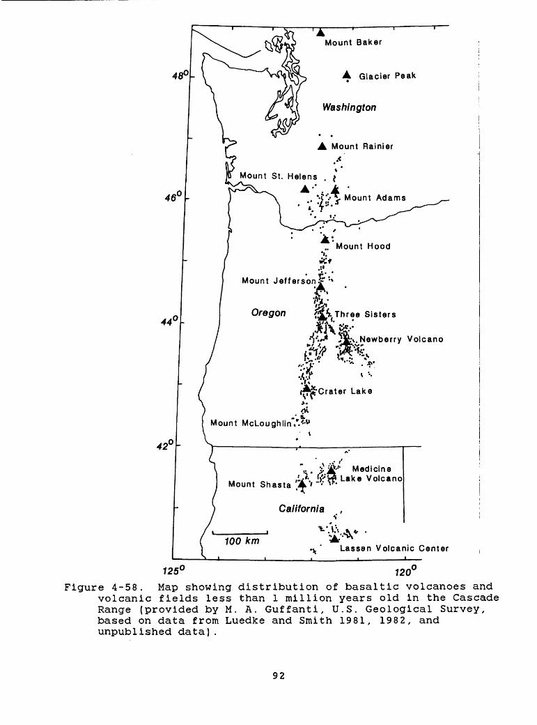
48°
Mount St. Helens . >
Mount Jefferson** :» v^1
WOregon {J^-Three Sisters
Mount McLoughlinV.'-u
120Figure 4-58. Map showing distribution of basaltic volcanoes and
volcanic fields less than 1 million years old in the Cascade Range (provided by M. A. Guffanti, U.S. Geological Survey, based on data from Luedke and Smith 1981, 1982, and unpublished data).
92
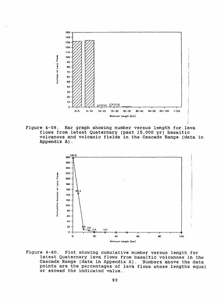
LT^_J ',
0-5 5-10
1777110-15 15-20 2O-30 30-4O
Minimum Length (km)
4O-50
I I
50-100 >100
Figure 4-59. Bar graph showing number versus length for lava flows from latest Quaternary (past 15,000 yr) basaltic volcanoes and volcanic fields in the Cascade Range (data in Appendix A).
100.0
4O 60
Minimum Length (km)
80 100
Figure 4-60. Plot showing cumulative number versus length forlatest Quaternary lava flows from basaltic volcanoes in the Cascade Range (data in Appendix A). Numbers above the data points are the percentages of lava flows whose lengths equal or exceed the indicated value.
93
Another type of basaltic activity is characterized by the concentration of many tephra and lava-flow eruptions at a central vent and several flank vents. This type of activity has built shield volcanoes typically 5-15 km in diameter and several hundred meters to more than 1000 m high. Many have summit cinder cones. Belknap in central Oregon is the youngest such shield volcano in the Cascades and has lava flows as young as 1400 yr.
Several large basaltic shield volcanoes along the range have steep-sided summit cones, such as Three-Fingered Jack (Davie, 1980), Mount Washington and North Sister (Taylor, 1981), Mount Bachelor (Taylor, 1978; Scott and Gardner, 1985), Diamond Peak, Mount Bailey, and Mount Thielsen (Sherrod, 1986), and Mount McLoughlin (Carver, 1972; Maynard, 1974). A few of these volcanoes contain rocks as silicic as andesite and may have been constructed during several eruptive episodes. These peaks rival the major composite cones in size but contrast with them in origin and structure. Most are composed of central scoria and tuff cones intruded by numerous dikes and one or more plugs. Thin lava flows intertongue with the scoria and mantle the central cone, and more voluminous lava flows typically extend beyond the base of the central cone. No evidence suggests that these volcanoes formed during highly explosive eruptions. Most lava flows and thick tephra-fall deposits are restricted within a few kilometers of vents, and scoriaceous tephras are typically not traceable farther than 20 km from vents (Taylor, 1965; W. E. Scott, unpublished data). Mount Bachelor, which is between 11,000 and 15,000 yr old (Scott and Gardner, 1985; W. E. Scott and C. A. Gardner, unpublished data), is the youngest of these volcanoes in the Cascades.
4.15.2 Volcanic-hazards assessmentHazardous effects of eruptions at basaltic volcanoes are
chiefly restricted to areas within 15 km of vents; however, a few lava flows of postglacial age have extended almost 30 km (Figs. 4- 59 and 4-60), and some Pleistocene lava flows have extended 80 km. The most serious hazards result from faulting and fissuring near vents, burial by lava flows and thick tephra, and impact by ballistic fragments and base surges. Beyond 15 km, lahars and floods might be expected downvalley from some eruptions in ice- or snow-covered areas. Also, lava flows and related clastic debris could dam streams and form lakes that could spillover catastrophically and generate lahars and floods extending downvalley for tens of kilometers. Such lakes would also inundate upstream areas. The damming of some of the larger streams in the Range such as the Cowlitz or Deschutes, or even the Columbia, would pose the greatest hazard. In addition, owing to their great relief and steep slopes, some of the large basaltic volcanoes could produce large debris avalanches and related lahars that could extend tens of kilometers away.
The large number of postglacial basaltic volcanoes in the Cascade Range (Appendix A) implies that the birth of a basaltic volcano has an annual probability of about 3 X 10"3' We determine
94
this probability by dividing the number of basaltic centers in Appendix A (about 40) by 15,000 yr. However, the prediction of specific locations for such events is probably not possible except a few days or weeks before an eruption. Figure 4-58 shows the basaltic vents that have been active in the Cascades over the past 1 million years and provides a basis for defining a hazard zone for future eruptions (section 5.5; Plate 1).
A potential hazard at the large basaltic volcanoes, such as Mount McLoughlin and Mount Bachelor, is the possibility of more explosive volcanism if magmas become more silicic. Some of the composite volcanoes in the range were initially basaltic volcanoes that evolved to more silicic and explosive activity. We have no way to estimate the probability of such a change at a given center.
The probability that an area in the Cascades will be covered by a lava flow in a given year is related generally to the long- term rate at which lava is extruded. Few well-supported rates have been published because of the lack of detailed mapping and chronologic control. However, Sherrod (1986) has calculated Quaternary extrusion rates in the area of the Oregon Cascades between latitudes 43° and 44° N of about 3-6 km3 /I million yr for each 1-km-long segment of the range. This figure implies that, on the average, a volume equivalent to that of the Belknap shield volcano (5 km3 ) is extruded each 1 million yr in each 1-km-long segment of the range. As the basal area of a shield of this size is approximately 80 km2 and the width of the range is typically 25-50 km, the mean frequency of coverage for any point in this part of the range is roughly 2-3 times per million years. This frequency translates to a mean annual probability of 2.5 x 10" 6 that a point will be covered by a lava flow. If the 5 km3 of magma were erupted from many vents, as would be the case for a field of scoria cones and lava flows, rather than largely from a central vent, the area covered could be several times greater than 80 km2 . Hence, by combining both modes of eruption, the annual probability would be greater than 3 x 10" 6 . The reliability of this estimate for other areas and for time periods less than 1 million years is difficult to evaluate. Data for the central Oregon Cascades indicate a frequency much higher than 2-3 times per million years. During the past 15,000 yr, the 110-km-long segment of the range from Odell Lake to Mt. Jefferson has had a mean extrusion rate of at least 30 km3 /my per 1 km of range length (W. E. Scott, unpublished data), which is about 10 times greater than the long-term, mean rate for latitude 43-44° N. This rate implies that the annual probability of areas in the central Oregon Cascades being covered by lava flows from basaltic volcanoes is on the order of 10" 5 and may locally be as low as 10"* .
95
CHAPTER 5
VOLCANIC-HAZARD ZONES FOR ERUPTIONS OF CASCADE RANGE VOLCANOES
5.1 Introduction
In this chapter, we establish and describe four categories of volcanic-hazard zones (Plates 1 to 4) that can be used for evaluating possible sites of nuclear-power plants in the Pacific Northwest: The four categories are: 1) proximal-hazard zones (Plate 1), which are circles with radii of 50 km centered on each of the 13 major volcanic centers described in Chapter 4; 2) distal lahar- and flood-hazard zones (Plate 1), which extend beyond the proximal-hazard zones down some major valleys that head at the 13 centers; 3) hazard zones for eruptions of basaltic volcanoes and volcanic fields (Plate 1), which include areas that have experienced this type of eruptive activity during the past 1 million years; and 4) tephra-hazard zones (Plates 2, 3, and 4), which show annual probabilities of the accumulation of 3 tephra thicknesses for most of the Pacific Northwest. This chapter also discusses the rationale used to establish hazard zones and the extent and probability of future hazardous events within them.
The hazard zones are based primarily on the premise that eruptive histories of volcanoes are the best available evidence of probable kinds, frequencies, and magnitudes of future eruptive events at those volcanoes. Annual probabilities of eruptions of various volumes can also be derived from eruptive histories, as can frequencies of various kinds of events.
The likelihood that future eruptions will affect certain areas is judged from the distribution of deposits of past eruptions, and from the frequency with which past volcanic events reached various distances from their sources. The frequency with which a given site has been affected decreases with increasing distance from a volcano, because an inverse relation exists between the size of specific events and their frequency (Mullineaux, 1976). For many volcanic phenomena, the severity of effects also decreases with increasing distance. In addition, the frequency and severity of effects of most flowage phenomena decrease with increasing height above adjacent valley or basin floors.
Volcanic events of very large volume or great extent are relatively rare, and can occur at volcanoes where they have not occurred before. Thus, for some hazard zones, some large-scale events are considered possible at volcanoes where they are not known in the eruptive record.
96
5.2 Proximal-hazard zones
Data in Appendix A and in Figures 5-1 to 5-6 indicate that most hazardous volcanic events are restricted to within about 50 km of their source. Evidence of the relatively high frequency and severe effects of volcanic events within a distance of 50 km from volcanoes is provided by the low proportion of flowage deposits that extend beyond 50 km, and by the thicknesses of tephra deposits within 50 km of their sources (section 3.3). In addition, strong atmospheric shock waves will have the most severe effects within 50 km of a volcano (section 3.5.2). Consequently, we have established a proximal-hazard zone with a radius of 50 km at each of the 13 major volcanic centers in the Cascade Range, all of which have been active during the past 100,000 years (Appendix A, Plate 1, Table 5-1). No nuclear power plants are now located within a proximal-hazard zone, although the Trojan Nuclear Plant in northwestern Oregon lies about 55 km west of Mount St. Helens. Because of the relatively high probability that future volcanic events will severely affect areas within these zones, sites proposed within them should undergo exceptionally careful investigations with respect to potential volcanic hazards (section 6.3.1). It may not be prudent to construct nuclear-power plants within these zones.
Figures 5-1 and 5-2 show that in the past 15,000 yr 20 percent of the lava flows in our compilation reached farther than 10 km from their vents, only one extended as far as 45 km, and no lava flow from a Cascade Range volcano reached as far as 50 km. However, a few lava flows of Pleistocene age (not compiled in Appendix A) traveled as far as 80 km.
Pyroclastic flows from only one eruption, that of Mount Mazama about 6850 yr ago, extended downvalley more than 50 km from their source (Figs. 5-3 and 5-4). Those pyroclastic flows reached about 60 km down the Rogue and Umpqua River valleys (section 4.11; Williams, 1942; Bacon, 1983; Druitt and Bacon, 1986), but because of valley configurations, even these pyroclastic flows terminated within a 50-km radial distance from the volcano. At least 5 percent of the pyroclastic flows shown in Figures 5-3 and 5-4 had traveled farther than 20 km from vents, and about 13 percent traveled farther than 15 km. However, because it is possible only to determine minimum lengths of pyroclastic flows (section 4.1), 15 percent represents a minimum proportion of pyroclastic flows longer than 15 km.
Data on debris avalanches are scarce for Cascade volcanoes, but very large ones seem to be rare. Only one, which occurred between 300,000 and 360,000 yr ago at Mount Shasta, reached more than 60 km from the source volcano (D. R. Crandell, oral commun., 1986; section 4.13). The large debris avalanche that occurred at the outset of the May 18, 1980 eruption of Mount St. Helens extended downvalley about 28 km from the volcano (Voight and others, 1981). The many debris avalanches that are less than 15 km long, and those that were transformed into lahars, are included with lahars in the compilations in this report.
97
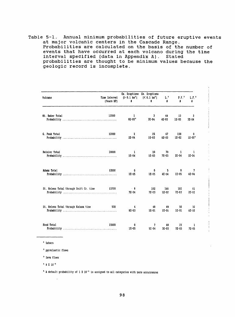
Table 5-1. Annual minimum probabilities of future eruptive events at major volcanic centers in the Cascade Range. Probabilities are calculated on the basis of the number of events that have occurred at each volcano during the time interval specified (data in Appendix A). Stated probabilities are thought to be minimum values because the geologic record is incomplete.
Ex. Eruptions Ex. EruptionsVolcano Tine Interval (> 0.1 km5 ) |< 0.1 kn1 ] L. 1 P.F.' L.F. 5
(Years BP| * I * * *
Kt. Baker Total 12000 1 3 44 13 3 Probability ......................................... 8E-05 4 3E-04 4E-03 IE-03 3E-04
G. Peak Total 12000 2 15 67 120 0 Probability ......................................... 2E-04 IE-03 6E-03 IE-02 1E-05 S
Rainier Total 10000 1 10 70 1 1 Probability ......................................... IE-04 IE-03 7E-03 IE-04 IE-04
Adams Total 12000 0 0507 Probability ......................................... IE-05 IE-05 4E-04 IE-05 6E-04
St. Helens Total through Swift Cr. time 13700 9 102 146 102 61 Probability ......................................... 7E-04 7E-03 IE-02 7E-03 2E-02
St. Helens Total through Kalana tine 500 4 49 49 50 32 Probability ......................................... 8E-03 IE-01 IE-01 IE-01 6E-02
Hood Total 15000 0 7 48 23 1 Probability ......................................... IE-05 5E-04 3E-03 2E-03 7E-05
1 lahars
2 pyroclastic flows
1 lava flows
4 8 I 10"
* K default probability of 1 I 10' 5 is assigned to all categories with zero occurrences
98
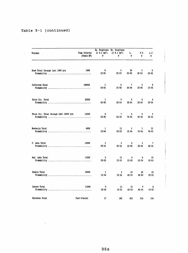
Table 5-1 (continued)
VolcanoEx. Eruptions Ex. Eruptions
Tine Interval |> 0.1 kn'| |< 0.1 kn'l L. P.F. L.F.(Years BP) » f f f f
Hood Total through last 1800 yrs 1SOO 0Probability ......................................... IE-05
Jefferson Total 100000 1Probability ......................................... IE-05
Three Sis. Total 25000 1Probability ......................................... 4E-05
Three Sis. Total through last 12000 yrs 12000 0Probability ......................................... IE-05
Hewberry Total 6850 1Probability ......................................... IE-04
C. Lake Total 12000 2Probability ......................................... 2E-04
Hed. Lake Total 11000 0Probability ......................................... IE-05
Shasta Total 10000 1Probability ......................................... IE-04
Lassen Total 11000 0Probability ......................................... IE-05
6 28 3 0 3E-03 2E-02 2E-03 IE-05
0720 IE-05 5E-04 2E-05 IE-05
9858 4E-04 3E-04 2E-04 3E-04
7853 6E-04 7E-04 4E-04 3E-04
12 1 1 21 2E-03. IE-04 IE-04 3E-03
2027 2E-04 IE-05 2E-04 6E-04
12 0 0 25 IE-03 IE-05 IE-05 2E-03
2 43 40 15 2E-04 4E-03 4E-03 2E-03
13 21 9 0 IE-03 2E-03 8E-04 IE-05
Cascades Total Post-Glacial 185 453 316 144
98a
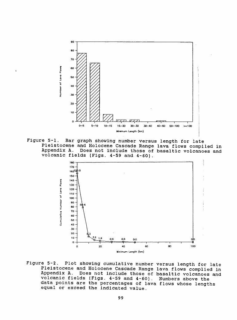
0-5 5-10 10-15 15-20 20-30 30-4O
Minimum Length (km)
4O-50 50-100 >-100
Figure 5-1. Bar graph showing number versus length for latePleistocene and Holocene Cascade Range lava flows compiled in Appendix A. Does not include those of basaltic volcanoes and volcanic fields (Figs. 4-59 and 4-60).
180
170-
0.0
4O 60
Minimum Length (km)
80
Figure 5-2. Plot showing cumulative number versus length for late Pleistocene and Holocene Cascade Range lava flows complied in Appendix A. Does not include those of basaltic volcanoes and volcanic fields (Figs. 4-59 and 4-60). Numbers above the data points are the percentages of lava flows whose lengths equal or exceed the indicated value.
99
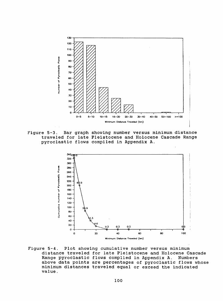
13O
120 -
110 -
100 -
9O-
80-
7O-
60 -
50 -
+0 -
30 -
20 -
10 -
0
0-5 5-10 10-15 15-20 20-30 30-40 4O-5O 50-100 >-10O
Minimum Distance Traveled (torO
Figure 5-3. Bar graph showing number versus minimum distance traveled for late Pleistocene and Holocene Cascade Range pyroclastic flows compiled in Appendix A.
0.3 0.3 0.3 00 {I
4O 60
Minimum Distance Traveled (tan)
80 100
Figure 5-4. Plot showing cumulative number versus minimumdistance traveled for late Pleistocene and Holocene Cascade Range pyroclastic flows complied in Appendix A. Numbers above data points are percentages of pyroclastic flows whose minimum distances traveled equal or exceed the indicated value.
100
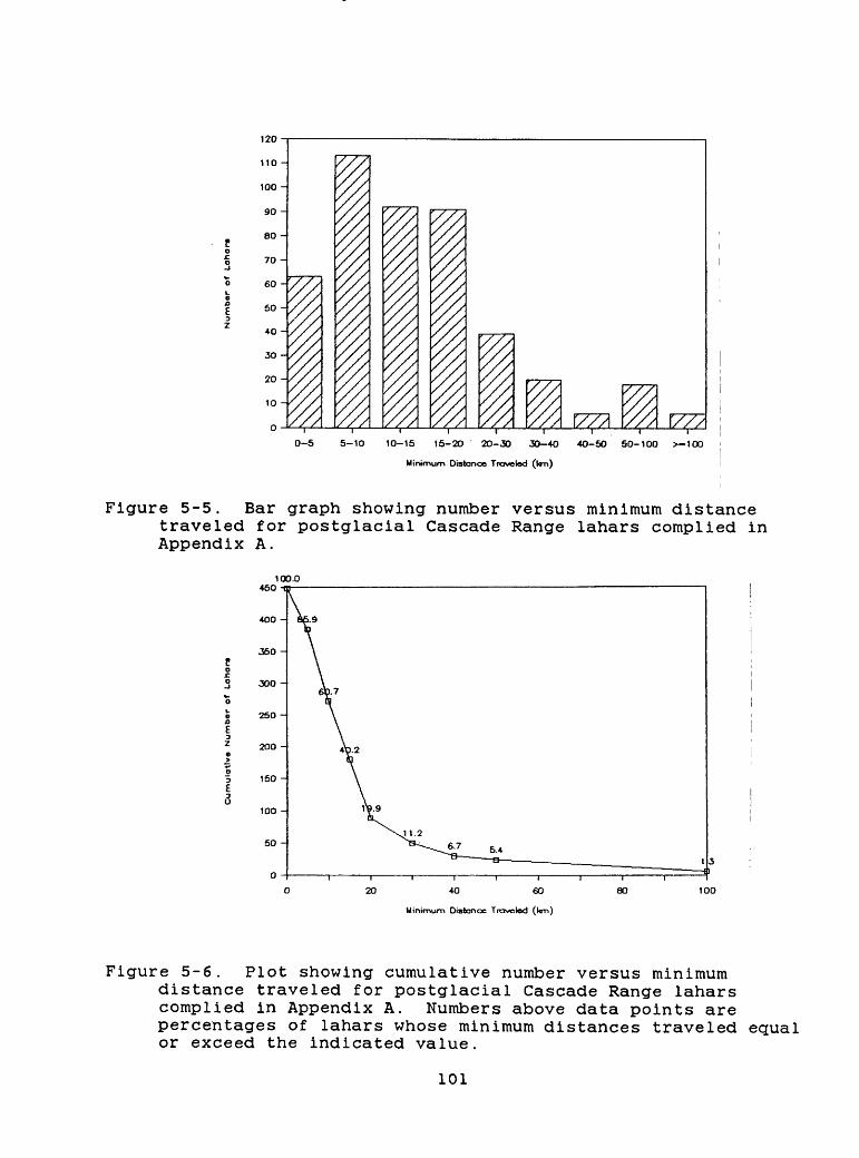
V7/0-5 5-10 10-15 15-20 20-30 30-4O 4O-50 50-100 >-1OO
Minimum Distance Traveled (tor>)
Figure 5-5. Bar graph showing number versus minimum distance traveled for postglacial Cascade Range lahars complied in Appendix A.
40 60
Minimum Distance Traveled (l<m)
80 100
Figure 5-6. Plot showing cumulative number versus minimum distance traveled for postglacial Cascade Range lahars complied in Appendix A. Numbers above data points are percentages of lahars whose minimum distances traveled equal or exceed the indicated value.
101
A compilation of minimum distances traveled by lahars from Cascade Range volcanoes (Figs. 5-5 and 5-6) shows that at least 20 percent of the lahars were 20 km or more long. A minimum of 5 percent reached more than 50 km, and at least 1 percent extended beyond 100 km from their source volcanoes.
Thick tephra can accumulate within 50 km of its source volcano, particularly in a downwind direction, which in the Pacific Northwest is generally toward the sector between northeast and southeast (Tables 5-2, 5-3; Fig. 3-1). Thus, the most severe effects of tephra will occur within proximal-hazard zones. Newhall (1982) points out that explosive eruptions that produce tephra with volumes greater than 0.1 km3 have a 10 percent probability of depositing 80 cm of tephra at a distance of 50 km, and considerably greater thicknesses would be deposited closer to the vent (Table 5-3). Most explosive eruptions that produce less than 0.1 km3 of tephra probably will result in less than 1 cm of tephra at a distance of 50 km (Newhall, 1982). Table 5-4 indicates a probability of only 1 percent that 3 cm of tephra will accumulate at a distance of 50 km from the vent.
The effects of volcanic gases and atmospheric shock waves on a nuclear power plant probably would be minimal at a distance of as much as 50 km from a volcano. Volcanic earthquakes are likely to be of lower magnitude than tectonic earthquakes, and thus would not present an additional problem at a distance of 50 km. Volcano-induced ground fractures probably would be a hazard only on the volcano itself.
Although a 50-km radius has been used as the boundary of the proximal-hazard zone for all 13 major volcanic centers, the probability that this zone will be affected, and in which way, varies from volcano to volcano. Table 5-1 summarizes the calculated minimum annual probabilities of various events based on past activity at each volcano during the time interval specified. The annual probabilities of explosive tephra eruptions of different sizes, and the annual probabilities of other hazardous events, vary by several orders of magnitude for the major Cascade volcanoes. For example, at Mount St. Helens the calculated annual probability of tephra eruptions that exceed 0.1 km3 in volume and of pyroclastic flows, both based on the record of the past 500 yr, are 8 x 10"* and 1 X 10" 1 , respectively (Table 5-1). In contrast, the calculated annual probabilities of similar events occurring at Mount Jefferson are 1 X 10" 5 and 2 X 10" 5 , respectively.
In general, the frequency with which areas within each proximal-hazard zone are affected by volcanic events decreases outward. However, factors other than distance are also involved, such as height above valley floors and wind directions. Thus, the flanks of volcanoes, immediately adjacent areas, and the heads of valleys draining the volcano will be affected most often and most severely by future events. Areas near the outer limit of the zone and areas that lie high above valley floors will be affected less frequently and, by some events, less severely. Valleys near the outer limit of the zones, that do not head on the volcano, are less susceptible to most flowage events; however, those valleys
102
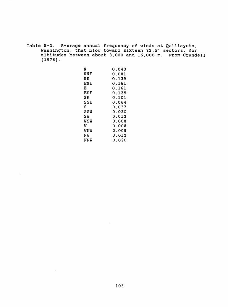
Table 5-2. Average annual frequency of winds at Quillayute,Washington, that blow toward sixteen 22.5° sectors, for altitudes between about 3,000 and 16,000 m. From Crandell (1976) .
N 0.043NNE 0.081NE 0.139ENE 0.161E 0.161ESE 0.125SE 0.101SSE 0.064S 0.037SSW 0.020SW 0.013WSW 0.008W 0.008WNW 0.009NW 0.013NNW 0.020
103
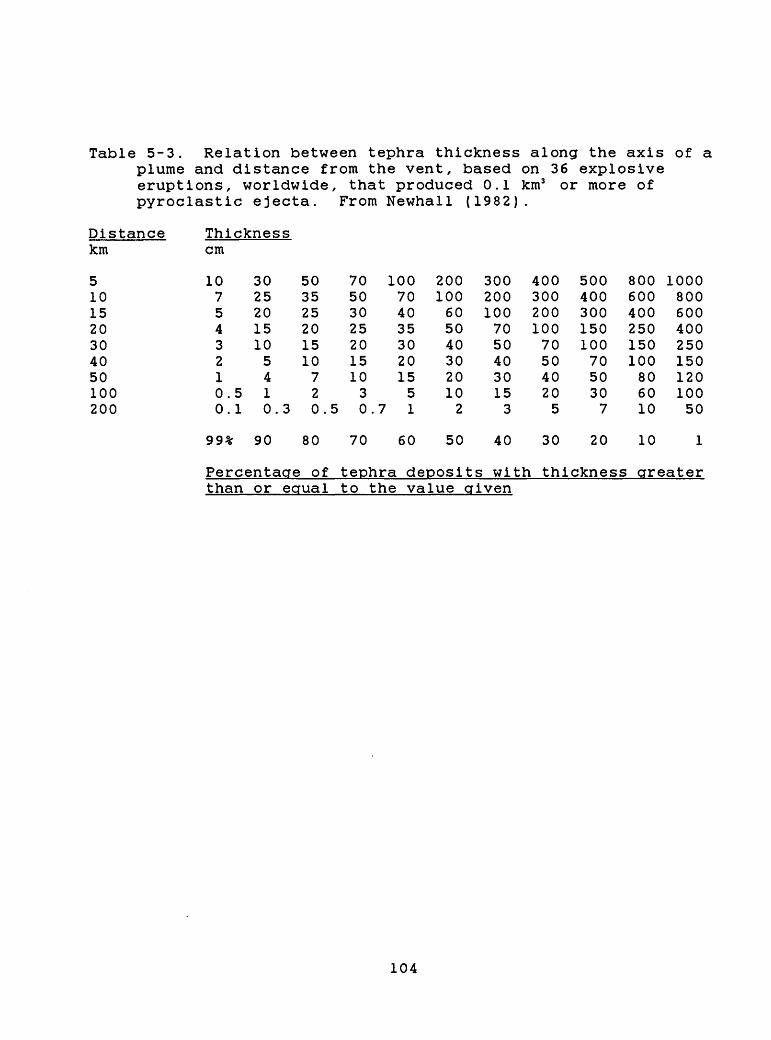
Table 5-3. Relation between tephra thickness along the axis of a plume and distance from the vent, based on 36 explosive eruptions, worldwide, that produced 0.1 km3 or more of pyroclastic ejecta. From Newhall (1982).
Distance km
5101520304050100200
Thickness cm
10 3025
5035
70 100 200 300 400 500 800 100050 70 100 200 300 400 600 800
5432100.5.1
2015105410.3
25201510720.5
302520151030.7
403530201551
6050403020102
10070504030153
200100705040205
3001501007050307
400250150100806010
60040025015012010050
99% 90 80 70 60 50 40 30 20 10
Percentage of tephra deposits with thickness greater than or equal to the value given
104
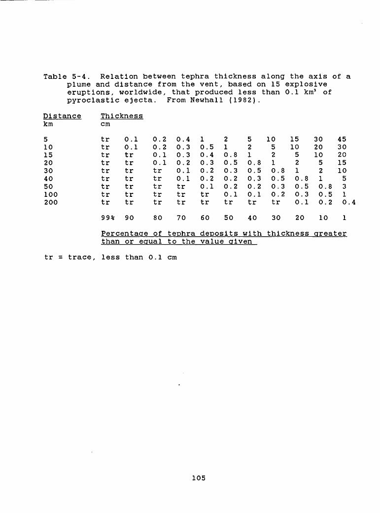
Table 5-4. Relation between tephra thickness along the axis of a plume and distance from the vent, based on 15 explosive eruptions, worldwide, that produced less than 0.1 km3 of pyroclastic ejecta. From Newhall (1982).
Distance km
5101520304050100200
Thickness cm
trtrtrtrtrtrtrtrtr
0.10.1trtrtrtrtrtrtr
0.20.20.10.1trtrtrtrtr
0.40.30.30.20.10.1trtrtr
10.50.40.30.20.20.1trtr
210.0.0.0.0.0.tr
853221
5210.80.50.30.20.1tr
105210.80.50.30.2tr
15105210000
.8
.5
.3
.1
3020105210.0.0.
852
45302015105310.4
99% 90 80 70 60 50 40 30 20 10
Percentage of tephra deposits with thickness greater than or equal to the value given
tr = trace, less than 0.1 cm
105
may be affected by large debris avalanches, lahars, lateral blasts, and pyroclastic flows and surges energetic enough to cross divides.
The radius of the proximal-hazard zone as defined here may exceed the maximum extent of previous events at some volcanoes. However, a zone of this size would create a buffer that should mitigate the effects of most future unprecedented events. The proximal-hazard zones of adjacent volcanoes overlap for most of the Cascade Range (Plate 1), creating a north-trending zone within which the maximum effects of future eruptions will be concentrated.
Pyroclastic flows, debris avalanches, and lahars and floods have extended beyond the proximal-hazard zone at some volcanoes, particularly down river valleys leading away from them. The distal lahar- and flood-hazard zone, discussed next, takes these events into account.
5.3 Distal hazard zones for lahars and floods
Two main groups of volcanic processes commonly affect areas more than 50 km from a vent: lahars and floods, the subject of this section, and tephra falls, discussed in section 5.4. Owing to great mobility and confinement to topographic depressions, lahars can reach tens to more than a hundred kilometers from a vent (section 3.2.7; Table 3-1). Figures 5-5 and 5-6 indicate that lahars that traveled a minimum distance of 50 km from Cascade Range volcanoes constitute about 5 percent of the total. This represents a minimum percentage as many of the lahars assigned minimum travel-distances of less than 50 km may have actually exceeded 50 km. In fact, lahars from several Cascade volcanoes- Glacier Peak, Mount Rainier, Mount Adams, Mount St. Helens, and Mount Hood--have inundated valley bottoms more than 50 km away.
The number of eruption-caused lahars and floods that have affected areas beyond proximal-hazard zones is not well documented for all volcanoes, in part because of lack of study, but also because many floods leave thin and discontinuous deposits that are difficult to identify or interpret correctly. Studies stimulated by the 1980 eruption of Mount St. Helens documented the transformation of lahars to hyperconcentrated flows to flood flows that affected areas more than 50 km downvalley (Pierson and Scott, 1985; Scott, 1985, 1986). There may have been more lahars and floods in the past in these distal areas than heretofore recognized, hence the probabilities given in this report may eventually have to be increased.
In addition to inundation by lahars and floods, distal-hazard zones are subject to changes in stream channels and flood plains resulting from events upstream. Increased sediment deposition persisting for years to decades after eruptions could greatly affect channel capacities, flood heights, and inundation areas of subsequent lahars and floods in distal-hazard zones.
In the Cascades during postglacial time, large-volume lahars and floods have occurred most often at snow- and ice-covered
106
volcanoes that have erupted frequently; they are almost nonexistent at volcanoes with little snow and ice or eruptive activity (Appendix A). Distal lahar- and flood-hazard zones (Plate 1) are shown at all 13 major Cascade volcanic centers except Medicine Lake and Newberry volcanoes, which lack permanent snow cover and have relatively gentle slopes. Distal lahar- and flood- hazard zones are shown along drainages that head directly on any of the other 11 major volcanoes, whether or not large lahars actually occurred at these volcanoes in postglacial time. The hazard zones extend downvalley to the nearest large reservoir or junction with a river valley whose capacity to contain lahars and floods is large enough to accommodate an increased flow without transmitting a significant hazard farther downvalley.
Distal lahar- and flood-hazard zones are showndiagrammatically on Plate 1, because the map is at a small scale, and the inundation areas depend on the detailed topography of a river valley. The hazard zones generally include active river channels, adjacent flood plains, and most low river terraces; an exact shape and extent of the hazard zone can only be determined in each valley by modelling past events and determining appropriate discharge and inundation levels for each drainage.
Within each distal lahar- and flood-hazard zone, hazard decreases gradually with increasing distance downvalley and more abruptly with increasing height above flood plains. Owing to variations in the size of the largest expectable lahar or flood from specific volcanoes and the effect of topography on the level of inundation, relative degrees of hazard should be evaluated on a site-by-site basis (see section 6.3.2).
5.4 Tephra-hazard zones
This section describes hazard-zonation maps for tephra from future eruptions of the 13 major Cascade volcanoes discussed in Chapter 4. Tephras, because they are carried by winds, can affect a greater area than any other type of volcanic hazard. Explosive eruptions commonly produce deposits more than 1 cm thick hundreds of kilometers from vents. For example, the May 18, 1980 eruption of Mount St. Helens, which produced about 0.2 km3 of tephra (magma equivalent), deposited about 5 cm of ash near Ritzville, Washington, 300 km to the east (Fig. 3-1; Sarna-Wojcicki and others, 1981) .
Zonation for potential tephra hazards should consider the variability in the frequency of explosive eruptions, the variability in the thickness of tephra that is deposited at various downwind distances, and the variability in wind directions. For this report, a method that combines these three factors has been used to produce contour maps of annual probabilities for specified tephra thicknesses.
Annual probabilities of specified tephra thicknesses were calculated for a grid (5-km spacing) of points covering the Pacific Northwest. The probability grid values were then contoured. For each grid point, the annual probability of the
107
specified accumulation from each of the 13 major Cascade volcanoes was determined. The probability estimate for each volcano is the product of three conditional probabilities: (1) the annual probability of an explosive eruption that produces 0.1 km3 or more of pyroclastic deposits (i.e., deposits of airfall tephra, pyroclastic flows, and pyroclastic surges); (2) the probability that the eruption will produce at least the specified tephra thickness at the volcano-to-grid-point distance; and (3) the mean annual probability that the given point is downwind from the volcano. The sum of these 13 volcano-specific probabilities constitutes the probability estimate for the given point.
The annual probability of an explosive eruption having a volume of 0.1 km3 or more at a given volcano was determined by compiling both historical and prehistorical data concerning eruptive activity of that volcano (Appendix A). The effective annual probability is the ratio of the number of eruptions to the time interval (in years) within which the eruptions occurred (see section 2.2; Table 5-1). Implicit in this procedure is the assumption that eruptions occur randomly in time. Therefore,
Probability = l-e'* /n ,
where t is the future time period to which the probability applies, and m is the mean recurrence interval (Dibble and others, 1985). In this report, the recurrence intervals are long enough that annual probabilities calculated from the above equation are effectively the same as the mean frequency, i.e., the ratio of the number of events to the number of years in which they occurred.
The subset of eruptions that produced less than 0.1 km3 of pyroclastic deposits was excluded from the calculations, even though such eruptions are more frequent than larger eruptions. This subset was excluded because these relatively small eruptions produce much less tephra than do eruptions of 0.1 km3 or more. In general, tephra from eruptions of less than 0.1 km3 would be less than 1 cm thick beyond the 50-km proximal-hazard zone (Tables 5-3 and 5-4; Newhall, 1982).
Although such small explosive eruptions were excluded from the analysis, they can not be ignored. Even small tephra accumulations have demonstrated a great capacity to disrupt technologically advanced societies (section 3.3; Schuster, 1981, 1983; Warrick and others, 1981).
For most major Cascade volcanoes, too few postglacial eruptions are documented for us to calculate a trustworthy eruption probability (Table 5-1). Indeed, most of the uncertainty in the calculations stems from the uncertainty in the annual eruption probability estimates. Nonetheless, in the absence of a more satisfactory alternative, an annual probability was assigned to each volcano by dividing the number of known explosive eruptions (volume >= 0.1 km3 ) by the duration of the eruptive record chosen. For some volcanoes with a high rate of postglacial activity, the chosen interval was less than 12,000 yr. For many volcanoes the past 12,000 yr, (postglacial time), was chosen. If
108
no suitable postglacial eruptions were known for that volcano, the interval was extended back to include older eruptions. If no suitable older eruptions were known, an eruption probability of 1 X 10" 5 /yr was arbitrarily assigned to that volcano in recognition of the fact that the probability is low, but finite.
Owing to its relative youth, its rather frequent eruptions, and the great deal of study it has received, the long-term eruptive behavior of Mount St. Helens is better understood than that of any other Cascade volcano. St. Helens' eruptions do not occur randomly in time; periods of relatively frequent activity are separated by periods of apparent repose. However, we have no reason to suppose that, within eruptive periods, eruptions that produced more than 0.1 km3 of tephra do not occur randomly in time. Therefore, the eruptive record for only the past 500 yr was selected. This time interval was chosen because we believe that the types and frequency of eruptive activity within it more accurately represent the probable near-future behavior than do longer time intervals, which include lengthy periods of dormancy.
The calculated mean annual probability that a given point will be downwind from a given volcano was based on National Weather Service wind-frequency data for a 20-year period reported by Crandell (1976; Table 5-2). These data are for sixteen 22.5° sectors for Quillayute, Washington, at altitudes between about 3,000 and 16,000 m, and were applied to the entire Pacific Northwest because high-level wind patterns are essentially the same throughout the region. The wind probabilities were assigned to the midpoints of their respective sectors; the probabilities for azimuths between midpoints were calculated by linear interpolation. A more rigorous analysis, appropriate for a specific site (section 6.3.4), would consider the small differences in wind-direction frequencies throughout the Pacific Northwest, the variation in wind speed, and the differences in both parameters with altitude.
The probability that an eruption will produce as much or more than a specified thickness of tephra along the axis of the tephra plume was taken from Newhall (1982; Tables 5-3 and 5-4).
Ideally, variation in tephra thickness with distance from the Cascade Range volcanoes could be used to estimate the probability that an eruption of a given volume would produce a specified tephra thickness at a specified distance. However, such data are too scanty to make meaningful estimates. Thus, data from Newhall's (1982), worldwide sample of eruptions were used (Table 5-3) .
Newhall's (1982) probability estimates were used here in the following fashion. A probability-distance relation was determined from Table 5-4 for three tephra thicknesses: greater than or equal to 1 cm, 10 cm, and 1 m. Probabilities were assigned to grid points that were less than 200 km (the maximum distance considered in Table 5-4) from a given volcano by linear interpolation between bracketing probability values from Table 5-4. To make probability estimates for distances greater than 200 km, an exponential least- squares curve was fit to the tabular values for each of the three
109
tephra thicknesses. An example is shown in Figure 5-7. The equations for these curves were then used to calculate probabilities for distances greater than 200 km.
The grid of probability values produced by the calculations was contoured at order-of-magnitude intervals. Plates 2, 3, and 4 are the resulting maps for tephra thicknesses equal to or greater than 1 cm, 10 cm, and 1 m, respectively. Note that Mount St. Helens tends to dominate the probability pattern, particularly on the 1-cm and 10-cm maps, because of its relatively high annual eruption probability. Mount St. Helens is not as dominant on the 1-m map because the probability of deposition of 1 m or more of tephra decreases more rapidly with distance from the source than do the probabilities for 1-cm and 10-cm accumulations.
The scheme described above has a number of shortcomings. The chief deficiency is the large uncertainty in estimates of annual eruption probability. Annual probabilities calculated from data in Table 5-1 should be considered minimum estimates, because of the incomplete geologic record and our limited ability to interpret that record. Some postglacial eruptions probably still remain unrecognized. For many Cascade volcanoes, the annual eruption probabilities are based on so few eruptions (in some cases no eruptions of that specific volcano) that the estimates are little more than best guesses. This problem is diminished to some extent by the relatively trustworthy eruption probability estimate for Mount St. Helens and the likelihood that some evidence of most eruptions in the Cascade Range larger than 0.1 km3 has been found. Because the Mount St. Helens estimate is more than an order of magnitude larger than that of any other Cascade volcano, the contribution of the low-probability volcanoes to the total Cascade probability is small, at least for the 1-cm and 10- cm maps. The probability patterns on the tephra-accumulation maps are sensitive to the annual probability estimates, which in turn vary according to the selection of a time interval at the various volcanoes. At Mount St. Helens, for example, time intervals that extend farther back than the past 500 yrs would yield lower probability estimates.
A second source of error in the total Cascade probability is uncertainty in the distance-thickness probability estimates. These estimates (Tables 5-3 and 5-4) are based on published distance-thickness data for 35 eruptions, which represent virtually all the data available at the time that Newhall (1982) compiled them. These data are biased towards larger eruptions
110
10 em or more of tephra0,8
0.7 -
0.6 -
0.5 -
0.4 -
0.3 -
0.2 -
0.1 -
0.4 0.6 (Thousands)
Distance (km)
0.8
Figure 5-7. Plot showing probability that an eruption of 0.1 km3 or more will deposit 10 cm or more of tephra at distances downwind from source volcano. Squares are data from Table 5 3; solid line is an exponential least-squares curve.
Ill
because the deposits of large eruptions are better preserved and more easily measured than the deposits of smaller eruptions. For this reason, more information exists concerning the products of large eruptions than of small eruptions. Newhall (1982) attempted to correct the values in his tables to compensate for this bias. However, data from the larger eruptions are still disproportionately represented (C. G. Newhall, personal commun., 1986). Consequently, the probability estimates taken from Table 5-3 are conservative; that is, they are somewhat larger than they should be. Nevertheless, these values are used because the error tends to negate underestimates in the annual eruption probabilities of Cascade volcanoes. Furthermore, over-estimates of probability introduce a safety margin into the calculations.
The accuracy of the probability maps can be roughly checked by comparing estimates based on these maps to tephra-accumulation frequencies determined at specific sites in the northwestern United States. Few sites faithfully preserve tephras over long time periods; the most propitious sites seem to be long-lived lakes. One such site Summer Lake, in south-central Oregon- accumulated tephras, with only one known brief depositional break, between about 16,000 and 335,000 yr ago (Davis, 1985). Fifty- three tephras were deposited within this time, so the mean frequency of tephra accumulation for this site has been about 2 X 10" 4 /yr for a period of 319,000 yr. Some of the tephras may not be from Cascade volcanoes, so the value for the Cascades may be somewhat lower. However, 2 X 10" 4 is probably a reasonable order- of-magnitude, long-term mean annual frequency of tephra deposition from Cascade volcanoes for this site. This value can be compared to the estimated probability from the tephra maps (Plate 4) if it is assumed that most of the tephra layers at Summer Lake are 1 cm thick or more (no published thickness data are available). Plate 4 shows an estimate of an annual probability of the accumulation of 1 cm or more of tephra at Summer Lake of 10" 3 . This value is influenced strongly by the annual eruption probability for Mount St. Helens, which in turn is based on the eruption frequency during the last 500 yrs, a more active time than earlier. If the mean long-term eruption frequency during the past 13,700 yrs, (Table 5-1) for Mount St. Helens were used, the probability map would yield an order-of-magnitude value of 10" 4 for the Summer Lake site. In other words, the probability maps are consistent with the limited site-specific data that are available if the long-term probability at Mount St. Helens is used instead of the short-term probability.
Because of the uncertainties of the analysis, the maps should be considered as semi-quantitative depictions of tephra- accumulation probabilities. Relative probabilities, the probability differences between points, are probably more trustworthy than the absolute value of the probability at those points. Furthermore, the contour patterns are, at least in a general way, probably realistic.
112
5.5 Hazard zones for eruptions of basaltic volcanoes and volcanic fields of the Cascade Range
In addition to the 13 major volcanic centers shown on Plate 1, many Quaternary volcanoes and fields of volcanoes are composed chiefly of basalt and basaltic andesite. These volcanoes typically formed during a single, relatively brief eruptive period; some basaltic volcanoes and volcanic fields, however, represent many eruptions. Both types are termed basaltic volcanoes in this report (section 4.15). Several similar volcanic fields are also shown in central Oregon east of the Cascades. The eruptions of basaltic volcanoes have produced widely different volumes of products, but typically were not highly explosive. The hazard zones on Plate 1 were constructed by drawing a circle with a 15-km radius around basaltic volcanoes in the Cascade Range and central Oregon that erupted during about the last 1 million years (Fig. 4-58). Even though some of these specific vents probably will not erupt again, the areas adjacent to them are likely sites of new vents.
A circular hazard zone with a radius of 15 km is used because the principal effects of eruptions of basaltic volcanoes are restricted to within that distance of vents. The most serious hazards are associated with lava flows, base surges, impact and burial by ballistic fragments, burial by thick accumulations of tephra, and faulting and fissuring near vents. During single eruptive episodes, surface faults and fissures may extend several kilometers beyond vents, and typically a chain of vents may open along a zone of fissures, some of which can extend for tens of kilometers. Thick tephra originating at basaltic volcanoes is generally restricted to within a few kilometers of vents; in most past eruptions, tephra accumulations have been negligible beyond 15 km. Lava flows have been by far the most voluminous product of past eruptions of basaltic volcanoes. Lava flows are typically less than 15 km long (Figs. 4-59 and 4-60), although some have exceeded 20 km. At some vents interaction of magma with ground water could cause violent explosions that can generate base surges (Table 3-1) and throw out ballistic blocks; these events seldom affect areas more than about 15 km from a vent. Beyond 15 km, hazards consist primarily of accumulation of thin deposits of tephra and lahars and floods extending downstream from vents in snow-covered areas. In addition, voluminous debris avalanches are possible at the larger, steep-sided basaltic volcanoes. It is possible, although unlikely, that such avalanches and associated lahars could extend down valleys beyond the basaltic-volcano hazard zones shown on Plate 1.
Within the basaltic-volcano-hazard zones shown on Plate 1, it is difficult to predict specifically where future eruptions are likely to occur; many basaltic volcanoes erupt only once, and the next eruption may be at a new site within the field. The probability that an area in the Cascades will be covered with lava erupted at a basaltic vent in a given year is related to the long- term rate at which lava is being erupted in the Cascade Range,
113
which is poorly known for most of the range. However, the annual frequency, averaged over a time period of 10 s yr, of coverage by lava flows for a point in the range is about 2-3 times per million years (see section 4-15). For some parts of the range, and for time intervals shorter than 1 million yr, rates may be greater by at least an order of magnitude. The annual probability of the birth of a basaltic volcano within the Cascade Range is on the order of 3 X 10' 3 .
114
CHAPTER 6
GENERAL GUIDELINES FOR EVALUATING VOLCANIC HAZARDSAT PROPOSED SITES FOR NUCLEAR POWER PLANTS
IN THE PACIFIC NORTHWEST
6.1 Introduction
This chapter presents general guidelines for evaluating volcanic hazards at proposed nuclear power plant sites in the Pacific Northwest. Overall guidelines for investigations are described first, then topics are considered more fully in discussions of the four categories of hazard zones outlined in Chapter 5.
Evaluation of potential volcanic hazards at specific sites uses the same rationale, methods, and kinds of information used to define the hazard zones described in Chapter 5; consequently, this discussion repeats many statements made there. Determination of the overall volcanic hazard the total of frequencies and magnitudes of all the kinds of volcanic events that can be anticipated at a site in the future is derived largely from scientific studies. In contrast, determination of the level of risk that is acceptable at such a site is chiefly a matter of public policy, subject to changing technological capabilities of hazard mitigation, and is not discussed herein.
Information that should be considered for evaluation of potential volcanic hazards at proposed sites includes:
1) Frequency and magnitude of various kinds of volcanic events that are recorded in the geologic history of the site itself, or that can be postulated for the site from the record geologic elsewhere. Adequate evaluation of volcanic hazards for a specific site requires best possible estimates of the frequency and magnitude of all kinds of hazardous volcanic events that could affect the site. Frequency and magnitude estimates should be as quantitative as possible, even though the estimates may have large uncertainties.
Ideally, identification of frequency and magnitude of events at a site would be sufficient to evaluate the volcanic hazard there; however, the record of events at a site is likely to be incomplete. Therefore, investigations of the eruptive record of nearby volcanoes and of the stratigraphic record up- and downvalley from the site are needed to add to this incomplete record.
Both the frequency and magnitude, and thus severity, of volcanic-hazard events vary widely from one potential site to another in the Pacific Northwest, especially with distance downvalley from different volcanoes, and with distance and direction from potential source vents. The hazard decreases primarily with increasing distance from an erupting volcano, and, for flowage phenomena, with height above valley floors.. The frequency with which events affect a site decreases with distance because large-magnitude events are less common than small ones;
115
sites that are progressively farther downvalley are subject to progressively fewer events. The severity of the effects of some events also decreases with increasing distance; many flowage deposits decrease in volume and thickness, and tephra deposits decrease in grain size and thickness.
The hazard from tephra varies with direction from volcanoes because winds over Cascade Range volcanoes blow dominantly toward easterly directions (Table 5-2). The tephra hazard at a site directly east of a volcano, for example, is an order of magnitude or more greater than it is at a comparable distance directly west of that volcano.
2) Eruptive histories of each volcano that could affect the site. A basic assumption of most volcanic-hazard evaluations is that the eruptive history of a volcano is the primary basis for assessing its likely future behavior. The eruptive history provides basic information for judging type, frequency, and magnitude of future events. However, the eruptive history deduced from geologic studies is likely to be incomplete; in particular, it probably lacks evidence of many small events, and perhaps of even some large ones. However, well documented eruptive events at a volcano provide models that can be logically used in postulating effects of similar eruptions at that volcano in the future.
Crandell and Mullineaux (1975, 1978), Crandell and others (1979), Miller (1980), Crandell (1980), Crandell and others (1984), and Scott (1985, 1986) discuss the techniques and rationale used in investigations of eruptive histories of Cascade Range volcanoes and provide some recent examples. Investigations include a compilation of information on eruptive behavior in historic time, which for most Cascade volcanoes is brief, and more importantly, stratigraphic studies of deposits around the flanks of a volcano and along valleys that drain it. Tracing and dating of the deposits, and interpretation of their origin lead to development of a record of past activity that includes information about the frequency, type, and magnitude of past eruptions and areas that were affected.
Determination of frequency of eruptions from all volcanoes that might affect a site allows calculation of total probabilities for the various phenomena. In the past, the frequency of eruptions has varied widely from one volcano to another, and the eruption frequency at one volcano might dominate the probability of eruptive effects at a site even far from that volcano. This point is illustrated in the discussion of tephra-hazard zones in section 5.4, which shows how Mount St. Helens' numerous past tephra eruptions dominate the probability distribution for future tephra falls throughout the Pacific Northwest. Obviously, the probability that a site will be affected by eruptions varies according to its proximity to different volcanoes whose eruptive frequencies differ, and according to the number of volcanoes that might affect the site.
116
3) Events of a type or magnitude that have not been recognized in the history of a given volcano, but which are known to have occurred at similar volcanoes elsewhere. Unprecedented events at a given volcano provide information about infrequent but large-magnitude events that may represent the greatest potential threat at a given site.
The Mount St. Helens eruptions of 1980 showed that events of unprecedented magnitude and character do occur, and therefore should be taken into account in evaluating hazards (Miller and others, 1981). Events that occurred at Cascade volcanoes other than the one under investigation, or at other volcanoes of similar type in similar tectonic settings elsewhere in the world, can be used as models. For example, the 1980 lateral blast at Mount St. Helens and others that have occurred in the circum-Pacific region are guides for evaluating the consequences of a laterally directed blast at a volcano that has not produced one in the past (Crandell and Hoblitt, 1986) .
The probability of an event of unprecedented magnitude or type at a given volcano is difficult to quantify; however, geologic, geophysical, and geochemical studies can help to narrow the uncertainty. For example, knowledge of the evolution and current state of a magma body could help greatly in forecasting future eruptive events. We have identified several Cascade volcanic centers at which a large-volume eruption similar to that of Mount Mazama might occur. Such an eruption requires a large, shallow body of silicic magma. Various studies have tried to determine whether such bodies exist beneath certain volcanoes {e.g., Bacon, 1985) .
4) Potential effectiveness of mitigation. Numerous mitigative measures are available for reducing the losses from volcanic events (e.g., UNDRO, 1985); however, their effectiveness varies greatly from place to place and for different types of eruptions. For example, a warning that lahars are flowing off a volcano is more useful for a site 50 km downvalley than one at 10 km because of the greater time for response. Also, engineering works to divert or contain flowage phenomena may be effective for small-volume events, but be overwhelmed by large ones. A significant aspect of planning mitigative measures is the uncertainty likely to accompany volcanic crises. The unrest that began at Mount Baker in 1975 has not led to an eruption, which illustrates the uncertainty in forecasting the course of activity (Frank and others, 1977). Mitigative measures that require decisions to be made during such crises must be formulated with an appreciation of the uncertainty that is likely to exist.
5) Possible adverse secondary effects of volcanic events on operations of a nuclear power plant. Numerous secondary effects of volcanic eruptions can impact operations; most concern possible interference with various plant systems. For example, the likelihood of interruption or contamination of cooling water supply or discharge may vary greatly from one site to another.
117
6.2 Evaluation criteria used in previous safety analysis reports for nuclear power plant sites in the Pacific Northwest
A limited number of approaches have been used to evaluate volcanic hazards at nuclear power plant sites in the Pacific Northwest (for example, Washington Public Power Supply System, 1981a and b; Shannon and Wilson, Inc., 1976; Portland General Electric, 1976). Most concentrated on reviewing postglacial eruptive behavior of nearby Cascade volcanoes and postulating the effects of future eruptions on the sites.
Tephra hazards were considered in greatest detail, because most of the sites were at locations not subject to lahars and pyroclastic flows. The approach consisted largely of using specific past tephra falls as models, given the type of volcanoes near the site, the history of tephra eruptions from these volcanoes or others of similar character, and the direction and distance from volcanoes in the region. The model eruptions included a wide volume range of Cascade eruptions or large historic eruptions elsewhere. Potential tephra thicknesses and loads at a site were estimated from plots of model thickness vs. distance.
The 1980 eruption of Mount St. Helens caused increased awareness of volcanic hazards. As a consequence, the Nuclear Regulatory Commission asked the operators of the Trojan Nuclear Plant, which lies along the Columbia River about 55 km west- southwest of Mount St. Helens, to reevaluate volcanic hazards at the site (Portland General Electric, 1980; Beaulieu and Peterson, 1981). Consultants analyzed the effects of the 1980 eruption on the plant and postulated what the effects would have been had the debris avalanche and lateral blast been directed southwestward rather than northward. They also analyzed the potential effects on the plant from future lahars from Mount St. Helens.
6.3 Guidelines for evaluation of sites in each hazard zone
We divide the following discussion into four sections depending on the location of a proposed site with respect to the four categories of zones described in Chapter 5 and shown on Plates 1 to 4: The 50-km zone of proximal hazards, the distal lahar- and flood-hazard zone, the hazard zone from eruptions of basaltic volcanoes and volcanic fields, and tephra-hazard zones beyond 50 km. The information needed to assess the volcanic hazards in each of these zones is summarized in Tables 6-1 to 6-4.
6.3.1 Proximal-hazard zonesAreas within 50 km of the 13 major Cascade volcanoes, which
we call proximal-hazard zones, are subject to most kinds of hazards associated with volcanoes. Some of these hazards are present between as well as during eruptions. Proximal-hazard zones will be most frequently and most severely affected by direct and indirect effects of future volcanism, although the frequency and severity may range widely within and among the zones. There
118
are presently no nuclear power plants within the proximal-hazard zones. However, sites have been proposed in the past that are within 50 km of Cascade volcanoes, such as the Skagit site near Sedro-Woolley, Washington.
For any site within a proximal-hazard zone, investigations of the stratigraphic record of eruptive products at and near the site and of the eruptive histories of nearby volcanoes are necessary to provide basic data about frequency and severity of effects that could impact the site. Many sites would be subject to hazardous events from more than one volcano, thus past histories of several nearby volcanoes might be required. The geologic events recorded by eruptive products at the site itself would provide only a minimum estimate of the kind, scale, and frequency of hazardous events at the site.
The record of activity should be analyzed for several time periods in order to cover fully the types, scales, and frequencies of eruptions at a given volcano. For example, the record of the last 4500 yr, and even the last 500 yr, at Mount St. Helens provides numerous and varied events of the type and magnitude that are likely to occur in the future. A longer time period, typically postglacial time (the last 12,000-15,000 yr), is needed for most other Cascade volcanoes in order to obtain a more complete sample. At volcanoes that have had little or no activity in postglacial time, like Mount Jefferson, the record of the last 50,000 to 100,000 yr needs to be analyzed. A record of a long time period is necessary even at volcanoes that have been recurrently active throughout postglacial time, in order to identify low-frequency, but large-magnitude, events such as large- volume tephra eruptions at Mount Rainier, or caldera-forming eruptions at Three Sisters, Newberry volcano, Medicine Lake volcano, and the Lassen volcanic center. We recommend that activity be analyzed over time periods of about 2000, 15,000, and 100,000 and 1 million yr.
The geographic position of the site should be reviewed relative to the varying frequency and severity of effects outward from nearby volcanoes. For flowage phenomena, both valleys heading on volcanoes and valleys separated from the volcanoes by low, potentially surmountable divides require attention. Evaluation of hazards from flowage events in relation to height above the valley floor is also necessary. For tephra hazards, the site should be reviewed in relation to frequency and strength of winds from the direction of nearby volcanoes. Tephra derived from large-volume eruptions of distant volcanoes might also be a hazard for sites within the proximal-hazard zones, and guidelines suggested later in section 6.3.4 are appropriate.
Evaluations also need to address unprecedented events that conceivably could affect the site, because areas within the proximal-hazard zone would most likely be affected by such events. In particular, the potential for debris avalanches, pyroclastic flows, lateral blasts, and tephra falls of greater magnitude than
119
those recorded at a specific site or at a specific volcano should be considered. The areal extent of postulated unprecedented events should be plotted with their origin at all nearby volcanoes.
The potential for mitigating the effects of volcanism, such as the short-term evacuation of people and movable property, and short- and long-term protection of fixed facilities, would vary greatly from site to site within the proximal-hazard zone. The effectiveness of mitigative measures would depend mostly on the location of the site relative to volcanoes and the accuracy of the forecasts of eruptive events. Sites in confined valleys with limited access, for example, could present problems in evacuating people or movable property. Sites near the outer limits of the zone would allow more time to carry out protective measures.
Adverse secondary effects of volcanism on plant operations would vary greatly from site to site within the proximal zone, but would generally decrease away from a volcano. Some secondary effects probably would also differ from time to time over short time periods. For example, the flood hazard would differ with changing meterological conditions. Other secondary effects could change markedly with the passage of longer periods of time. For example, the capacities of channels and flood plains to affect flood levels could be reduced as a result of increased sediment loads.
If a nuclear power plant were sited within 50 km of any of the major Cascade volcanoes, we recommend that the current state of that volcano (or volcanoes) be monitored. By using appropriate geophysical and geochemical techniques, scientists could probably provide timely warning of eruptions (e.g., UNESCO, 1971; Newhall, 1984; Decker, 1986). For example, one week of premonitory earthquake activity in March 1980 preceded the initial eruption of the present eruptive period at Mount St. Helens (Malone and others, 1981). Although a specific prediction of the magnitude and timing of the catastrophic eruption of May 18, 1980, was not possible, continuing seismicity, ground deformation, and phreatic explosions between March and May provided warning of an increased probability of more and larger eruptions. After May 18, most eruptions of Mount St. Helens have been predicted successfully (Malone and others, 1981; Swanson and others, 1981, 1983). Although some hazardous events at volcanoes can begin with little warning, especially debris avalanches and lahars unrelated to eruptions, and premonitory activity and small phreatic eruptions don't always lead to major magmatic eruptions (e.g., Fiske, 1984), a monitoring system can greatly increase the chance that an eruption will be anticipated.
120
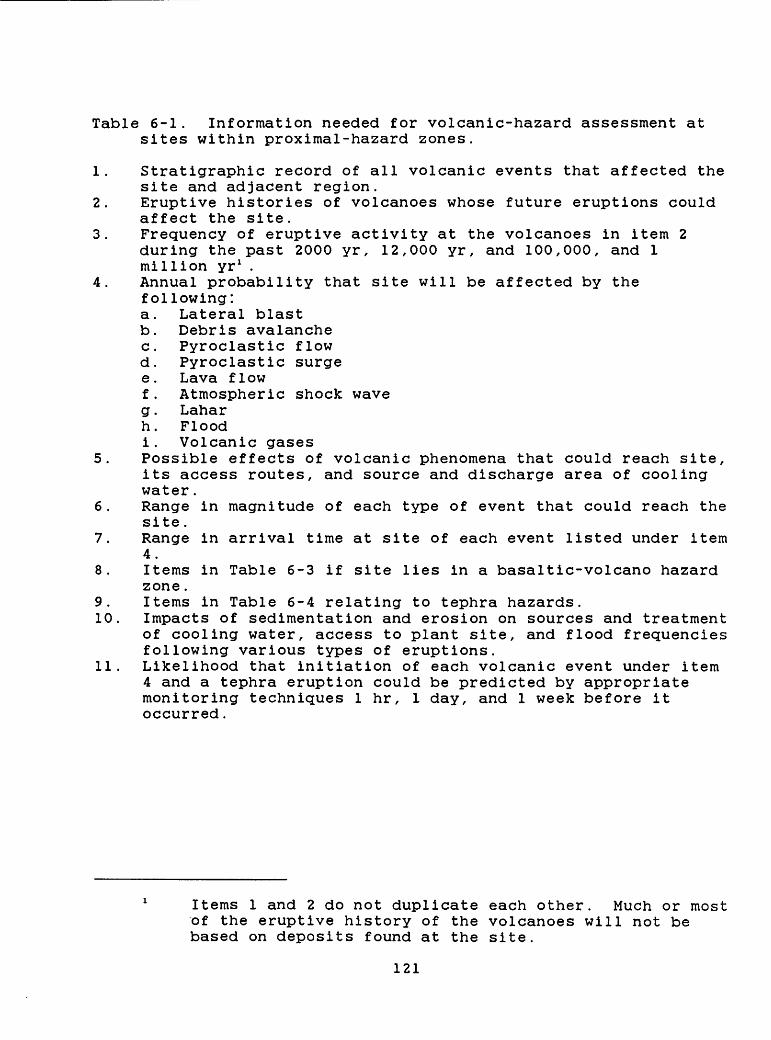
Table 6-1. Information needed for volcanic-hazard assessment at sites within proximal-hazard zones.
1. Stratigraphic record of all volcanic events that affected the site and adjacent region.
2. Eruptive histories of volcanoes whose future eruptions could affect the site.
3. Frequency of eruptive activity at the volcanoes in item 2 during the past 2000 yr, 12,000 yr, and 100,000, and 1 million yr 1 .
4. Annual probability that site will be affected by the following: a. Lateral blast b. Debris avalanche c. Pyroclastic flow d. Pyroclastic surge e. Lava flow f. Atmospheric shock wave g. Lahar h. Flood i. Volcanic gases
5. Possible effects of volcanic phenomena that could reach site, its access routes, and source and discharge area of cooling water.
6. Range in magnitude of each type of event that could reach the site.
7. Range in arrival time at site of each event listed under item 4.
8. Items in Table 6-3 if site lies in a basaltic-volcano hazard zone.
9. Items in Table 6-4 relating to tephra hazards.10. Impacts of sedimentation and erosion on sources and treatment
of cooling water, access to plant site, and flood frequencies following various types of eruptions.
11. Likelihood that initiation of each volcanic event under item 4 and a tephra eruption could be predicted by appropriate monitoring techniques 1 hr, 1 day, and 1 week before it occurred.
Items 1 and 2 do not duplicate each other. Much or most of the eruptive history of the volcanoes will not be based on deposits found at the site.
121
6.3.2 Distal lahar-and flood-hazard zonesValleys beyond the 50-km proximal-hazard zone around many of
the major Cascade volcanoes are identified in Plate 1 as being at risk from flowage phenomena, chiefly because lahars, lahar-runout flows, and floods could inundate them during future eruptions. Debris avalanches and pyroclastic flows of the largest scale known from Cascade Range volcanoes could also extend beyond proximal- hazard zones. Owing to their downvalley distance from volcanoes, these distal zones are affected only by less frequent, but large magnitude, flowage events. The threat of inundation in distal zones is limited to valley floors or topographic basins. Sites in distal-hazard zones are also subject to tephra falls from other volcanoes, which are treated in section 6.3.4.
A hazard assessment for a site in the distal zone should include an analysis of past eruptive behavior of all volcanoes drained by streams that lead to the valley containing the site. Volcanoes that are separated from the drainage basin in which the site lies by low, potentially surmountable divides also need to be studied. Geological investigations at the site itself should be made to determine the record of lahars, lahar-runout flows, and floods that can be identified there. Because the record at the site itself is likely to be incomplete, however, the investigations should be extended to the entire drainage basin to search for evidence of events not identified at the site. In addition to identifying events, the investigations should also gather data on the depth of flows and inundation levels. Crandell and Mullineaux (1975, 1978) and Scott (1985, 1986) discuss the techniques for carrying out these investigations and their rationale.
The likelihood and effects of flowage events of unprecedented type or magnitude should also be assessed for each volcano whose eruptions could affect the site. Such an assessment can be done by analogy with events at volcanoes elsewhere or by models such as lahar- or flood-routing (e.g., Dunne and Leopold, 1981; Lang and Dent, 1983; Laenen and others, 1987). Many valleys that drain Cascade Range volcanoes contain reservoirs that may act as traps for lahars and floods (e.g., Crandell and Mullineaux, 1978). However, the effects of failure of dams upstream from the site should be analyzed because such failures could greatly increase the volume of lahars and floods above those in the geologic record. Also, several processes can form debris-dammed lakes, the sudden release of which might produce lahars and floods of unprecedented magnitude (Jennings and others, 1981; Scott, 1986).
Some pyroclastic flows of Quaternary age from Cascade Range volcanoes traveled beyond the 50-km proximal zone. Therefore, investigations should provide an estimate of the probability that sites in the distal zone would be affected by large-volume pyroclastic flows being generated at nearby volcanoes.
Possibly adverse secondary effects of eruptions on stream channels and flood plains in distal-hazard zones also should be assessed. Lahar- and flood-inundation zones may be altered due to aggradation or other changes caused by the passage of lahars and
122
floods (e.g., Lombard and others, 1981; U.S. Army Corps of Engineers, 1984). This includes both events that directly affect areas adjacent to the site and those whose direct effects are restricted to areas upvalley of the site. If streams provide cooling water for the plant, the effects of lahars and floods, and channel changes on intake and outflow structures should be analyzed. Furthermore, the effects of eruptive products on sediment concentration and changes in water quality must be assessed.
123

Table 6-2. Information needed for volcanic-hazard assessment at sites in distal lahar- and flood-hazard zones.
1. Stratigraphic record of lahars and floods at site and in drainage basin in which site is located.
2. Inundation levels of past lahars and floods near the site.3. Frequencies of lahars and floods in the drainage basin of the
site during the past 2000, 15,000, and 100,000 yr.4. Eruptive histories of nearby volcanoes lying in same drainage
basin as site, or that are separated from basin by low divide that could be overtopped by large-volume lahars or debris avalanches.
5. Analysis of likelihood and effects of debris avalanches,lahars, and floods of unprecedented magnitude occurring at site.
6. Record of large-volume pyroclastic flows that occurred atnearby volcanoes, and analysis of the probability of future such pyroclastic flows reaching site.
7. Analysis of secondary effects of eruptions at the site,including impacts on flood stages, intake and discharge works for cooling water, access routes, etc.
8. Items in Table 6-4 relating to tephra hazards.9. Evaluation of the effectiveness of mitigative measures.10. Likelihood that initiation of eruptions that could affect
site could be predicted by appropriate monitoring techniques 1 hr, 1 day, and 1 week before it occurred.
124
6.3.3 Hazard zones for basaltic volcanoes and volcanic fieldsThe hazard zone for basaltic volcanoes and volcanic fields in
much of the Cascade Range is superimposed on proximal-hazard zones (Plate 1). For sites that lie in both zones, the guidelines presented here should be combined with those discussed in the section on proximal-hazard zones. A hazard assessment of a site within the basaltic-volcano hazard zone should include the past history of basaltic eruptions in a wide region of perhaps 50-km radius around the site. Such hazard assessments have been prepared for several sites at the Idaho National Engineering Laboratory in southeastern Idaho (Kuntz and Dalrymple, 1979; Kuntz and others, 1980).
Particular attention should be paid to the possibility of a new vent appearing at or near a power-plant site. Faults, major fractures, and other zones of weakness should be explored and evaluated as potential loci for the formation of vents.
Certain areas of the Cascade Range have had much more basaltic volcanism in postglacial time than others (section 4.15); however, over the past one million years, such eruptions have occurred throughout much of the range between Mount Rainier and Lassen Peak (Figure 4-58). Current knowledge is insufficient to predict accurately the time and location of future eruptions. However, the past frequency of eruptions over time intervals of 10,000 to 1 million yr suggests that areas along the range have annual probabilities on the order of 10"* to 10" 6 of being affected by future eruptions. Studies of specific sites should result in a more precise probability estimate.
As in the other hazard zones, the possibility of events of very large or unprecedented magnitude should also be addressed. Some Quaternary lava flows in the Cascade Range are up to 6 times longer than the 15-km length used in defining the basaltic-volcano hazard zone.
Potential hazards from lahars and floods that could be generated by eruptions of basaltic volcanoes also should be addressed. Breaching of lava-flow dams that formed large lakes could generate catastrophic lahars and floods. An evaluation should also be made of the potential for flooding of the site by lakes dammed by lava flows.
125
Table 6-3. Information needed for volcanic-hazard assessment at sites in basaltic-volcano hazard zones.
1. Eruptive history of basaltic volcanoes in an area of about 50-km radius around site.
2. Frequency of eruptions of basaltic volcanoes in area of item 1 during past 10,000, 100,000, and 1 million yr.
3. Geologic structures around plant site that might control loci of new vents.
4. Surface deformation at site that might accompany eruptions of nearby vents.
5. Ground- and surface-water conditions around site that would influence eruptive behavior at nearby vents; especially related to generation of pyroclastic surges.
6. Potential for flooding of site behind lava-flow dams.7. Lahar and flood hazards from eruptions and from breaching of
lava-flow dams.8. Items in Table 6-2 if site also lies in distal lahar- and
flood-hazard zone.9. Items in Table 6-4 relating to tephra hazards.
126
6.3.4 Tephra-hazard zonesA nuclear-power plant site anywhere in the Pacific Northwest
is subject to hazards from tephra fall. Past tephra eruptions, particularly those of Glacier Peak, Mount St. Helens, and Mount Mazama, affected broad regions in and beyond the Pacific Northwest (Fig. 3-1). The tephra-hazard zones shown on Plates 2-4 illustrate the range in probability for three different tephra thicknesses, based on eruptive histories of major Cascade volcanoes (see section 5.4).
Studies to further evaluate tephra hazards at a specific site should determine the record of late Quaternary tephra falls in a broad region around the site, and identify the sources of the tephra. It may be necessary to investigate a region of hundreds to thousands of square kilometers to assemble a complete record of tephra falls, including their grain size and original thickness. Recent reports by Sarna-Wojcicki and others (1983) and Shipley and Sarna-Wojcicki (1983) can help guide studies.
Analysis should also be made of potential maximum tephra falls by using, as analogs or models, past large-scale tephra falls from Cascade Range volcanoes, even if such large events are unprecedented at volcanoes nearest the site. Tephra from the climactic eruption of Mount Mazama, and layer Yn from Mount St. Helens (Fig. 3-1), have been used at other Cascade volcanoes as examples of maximum expectable examples to analyze a postulated worst-case tephra fall at specific sites. In these models, the axis of maximum thickness was directed toward the site from the closest volcano thought to be capable of such an eruption.
Estimates of the probability that a large-scale tephra eruption would occur, as judged from past activity at the volcano as well as wind-direction data, can be used to assess the order- of-magnitude probability of a fall affecting a site. Several largely subjective judgments are required for this analysis (section 5.4), and varying degrees of conservatism can be obtained by the assumptions used.
Figure 3-1 shows distance versus thickness plots for three large-volume tephra deposits of postglacial age from Cascade volcanoes, as well as the relatively small-volume deposit from the May 18, 1980, eruption of Mount St. Helens. The thicknesses of the three large deposits are for compacted tephra, and have not been adjusted to represent loose, freshly fallen tephra. Observations of historic falls suggest that the thickness of freshly fallen tephra is approximately halved by compaction (Blong, 1982). These curves can be used to develop a worst-case tephra fall at a site. For example, a site 300 km from a potential source volcano could receive about 10-14 cm of uncompacted tephra from an eruption similar in volume to those that deposited the Glacier Peak G or Mount St. Helens Yn tephras. Three eruptions of this size have occurred in the Cascades in postglacial time. In contrast, a Mazama-type eruption might result in about 50 cm of uncompacted tephra at a distance of 300 km. The probability of this thickness accumulating at a given
127
site is low (Plates 3 and 4), because of the low probability of such a large eruption from a given volcano and the variable probability of the wind blowing in a direction that would carry the tephra toward the site.
Mitigation of effects of tephra falls require data about warning of impending eruptions and probable conditions during a tephra fall. Studies should determine minimum and most likely times between an eruption and beginning of tephra effects at a site. They should also provide data on probable rate, grain size, and duration of tephra fall, and duration of darkness or poor visibility caused by the event. Effects on access to and from the site during and after a tephra fall should be considered.
The rate at which tephra will accumulate during a fall depends on many factors, including mass-eruption rate, height of the eruption column, wind direction and speed, and distance from the volcano. Estimates of duration of fall, rate at which tephra accumulates, and duration of periods of darkness and poor visibility can be derived from records of historical eruptions. Information on fall rates is best obtained from measurements made during historical tephra falls, although these measurements are few and the rates are generally averages. Blong (1982) compiled data on the duration of darkness that accompanied some historical eruptions and the total thickness of uncompacted tephra that accumulated at the site where the darkness occurred. If most of the tephra fell during the time of darkness, the mean rates of accumulation vary from less than 1 to almost 20 mm/hr. These values are for total tephra thicknesses that range from 1-300 mm (see summary in Blong, 1982), equivalent to the range of tephra thicknesses for all but large-volume eruptions at distances greater than 50 km from the source volcano. Durations of tephra falls from eruptions as large as those of Mount St. Helens Yn and Glacier Peak G probably lasted from several hours to several days.
An analysis should also be made of potential tephra loads. Estimates of loads on structures at a site can be obtained by using densities of 0.4-0.7 g/cm3 for expected thickness of dry, uncompacted tephra (Blong, 1981); densities of wet tephra could be twice as large. An important consideration is the effect of drifting of tephra by wind, which can produce locally thick deposits and result in point loads on small areas that are far greater than the average load of undisturbed tephra.
Potentially adverse secondary effects of tephra falls should also be evaluated. Reworking of tephra by wind and water could affect cooling-water facilities and other plant operations for long time periods after a tephra fall.
128
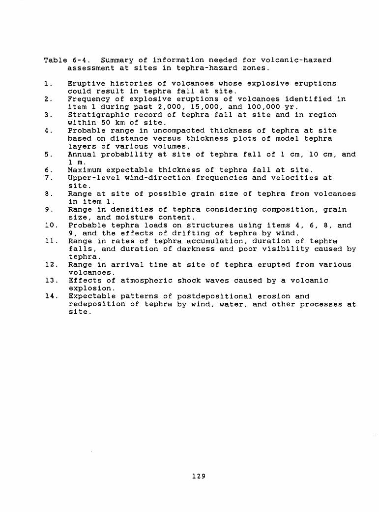
Table 6-4. Summary of information needed for volcanic-hazard assessment at sites in tephra-hazard zones.
1. Eruptive histories of volcanoes whose explosive eruptions could result in tephra fall at site.
2. Frequency of explosive eruptions of volcanoes identified in item 1 during past 2,000, 15,000, and 100,000 yr.
3. Stratigraphic record of tephra fall at site and in region within 50 km of site.
4. Probable range in uncompacted thickness of tephra at site based on distance versus thickness plots of model tephra layers of various volumes.
5. Annual probability at site of tephra fall of 1 cm, 10 cm, and 1 m.
6. Maximum expectable thickness of tephra fall at site.7. Upper-level wind-direction frequencies and velocities at
site.8. Range at site of possible grain size of tephra from volcanoes
in item 1.9. Range in densities of tephra considering composition, grain
size, and moisture content.10. Probable tephra loads on structures using items 4, 6, 8, and
9, and the effects of drifting of tephra by wind.11. Range in rates of tephra accumulation, duration of tephra
falls, and duration of darkness and poor visibility caused by tephra.
12. Range in arrival time at site of tephra erupted from various volcanoes.
13. Effects of atmospheric shock waves caused by a volcanic explosion.
14. Expectable patterns of postdepositional erosion andredeposition of tephra by wind> water, and other processes at site.
129
REFERENCES
Adair, M. J., 1979, Geologic evaluation of a site for a nuclear power plant: Geological Society of America, Reviews in Engineering Geology, v. 4, p. 27-39.
Anderson, C. A., 1940, Hat Creek lava flow: American Journal of Science, v. 238, p. 477-492.
Anderson, C. A., 1941, Volcanoes of the Medicine Lake Highland, California: University of California Publications, Bulletin of the Department of Geological Sciences, v. 25, p. 347-422.
Aramaki, Shigeo, 1956, The 1783 activity of Asama volcano. PartI: Japanese Journal of Geology and Geography, v. 27, p. 189- 229.
Bacon, C. R., 1983, Eruptive history of Mount Mazama and Crater Lake Caldera, Cascade Range, U.S.A.: Journal of Volcanology and Geothermal Research, v. 18, p. 57-115.
Bacon, C. R., 1985, Implications of silicic vent patterns for the presence of large crustal magma chambers: Journal of Geophysical Research, v. 90, no. B13, p. 11,243-11,252.
Bailey, R. A., 1981, Volcanic evolution and potential hazards in the Long Valley-Mono, Coso, and Clear Lake volcanic areas, California: California Division of Mines and Geology, Special Publication 63, p. 17-28.
Banks, N. G., and Hoblitt, R. P., 1981, Summary of temperaturestudies of 1980 deposits, in Lipman, P. W., and Mullineaux, D. R., eds., The 1980 eruptions of Mount St. Helens, Washington: U.S. Geological Survey Professional Paper 1250, p. 295-313.
Bannister, J. R., 1984, Pressure wave generated by the Mount St. Helens eruption: Journal of Geophysical Research, v. 89, p. 4895-4904.
Beaulieu, J. D., and Peterson, N. V., 1981, Seismic and volcanic hazard evaluation of the Mount St. Helens area relative to the Trojan nuclear site: Oregon Department of Geology and Mineral Industries Open-File Report 0-81-9, 80 p.
Beget, J. E., 1981, Evidence of Pleistocene explosive eruptions of Mount Jefferson, Oregon [abs]: Transactions of the American Geophysical Union, EOS, v. 62, p. 1089.
Beget, J. E., 1982, Postglacial volcanic deposits at Glacier Peak, Washington, and potential hazards from future eruptions: U.S. Geological Survey Open-file Report 82-830, 77 p.
130
Beget, J. E., 1983, Glacier Peak, Washington: A potentiallyhazardous Cascade volcano: Environmental Geology, v. 5, p. 83-92.
Blinman, Eric, Mehringer, P. J., Jr., and Sheppard, J. C., 1979, Pollen influx and the deposition of Mazama and Glacier Peak tephra, in. Sheets, P. D., and Grayson, D. K., eds., Volcanic activity and human ecology: New York, Academic Press, p. 393- 425.
Blong, R. J., 1981, Some effects of tephra falls on buildings, in, Self, S., and Sparks, R. S. J., eds., Tephra studies: Dordrecht, Holland, Reidel, p. 405-420.
Blong, R. J., 1982, The time of darkness: Seattle, University of Washington Press, 257 p.
Blong, R. J., 1984, Volcanic hazards: A sourcebook on the effects of eruptions: Orlando, Florida, Academic Press, 424 p.
Bogoyavlenskaya, G. E., Braitseva, 0. A., Melekestev, I. V.,Kiriyanov, V. Yu., and Miller, C. Dan, 1985, Catastrophic eruptions of the directed blast type at Mount St. Helens, Bezymianny, and Shiveluch volcanoes: Journal of Geodynamics, v. 3, p. 189-218.
Borchardt, G. A., Harward, M. E., and Schmitt, R. A., 1971,Correlation of volcanic ash deposits by activation analysis of glass separates: Quaternary Research, v. 1, p. 247-260.
Borchardt, G. A., Norgren, J. A., and Harward, M. E., 1973,Correlation of ash layers in peat bogs of eastern Oregon: Geological Society of America Bulletin, v. 84, p.3101-3108.
Burnett, Peter H., 1902, The letters of Peter H. Burnett: Oregon Historical Quarterly, v. 3, p. 424.
Cameron, K. A., and Pringle, Patrick, 1986, Post-glacial lahars of the Sandy River basin, Mount Hood, Oregon: Northwest Science, v. 60, p. 225-237.
Carey, S. N., and Sigurdsson, Haraldur, 1982, Influence ofparticle aggregation on deposition of distal tephra from the May 18, 1980, eruption of Mount St. Helens: Journal of Geophysical Research, v. 87, p. 7061-7072.
Carrara, P. E., Short, S. K., and Wilcox, R. E., 1986,Deglaciation of the mountainous region of northwestern Montana, U.S.A., as indicated by late Pleistocene ash: Arctic and Alpine Research, v. 18, p. 317-325.
131
Carver, G. A., 1972, Glacial geology of the Mountain LakesWilderness and adjacent parts of the Cascade Range, Oregon: unpublished Ph.D. dissertation, University of Washington, Seattle, 75 p.
Chitwood, L. A., Jensen, R. A., and Groh, E. A., 1977, The age of Lava Butte: The Ore Bin, v. 39, p. 157-164.
Christiansen, R. L., 1982, Volcanic hazard potential in the California Cascades: California Division of Mines and Geology, Special Publication 63, p. 41-59.
Christiansen, R. L., 1985, The Mount Shasta magmatic system, inGuffanti, M., and Muffler, L. J. P., eds., Proceedings of the Workshop on Geothermal Resources of the Cascade Range: U.S. Geological Survey Open-File Report 85-521, p. 31-33.
Christiansen, R. L., and Clynne, M. A., 1986, The climacticeruptions of Lassen Peak, California, in May 1915 [abs]: Transactions of the American Geophysical Union, EOS, v. 67, p. 1247.
Christiansen, R. L. and Miller, C. D., 1976, Volcanic evolution of Mt. Shasta, California: Geological Society of America Abstracts with Programs, v. 8, p. 360-361.
Christiansen, R. L., and Peterson, D. W., 1981, Chronology of the 1980 eruptive activity, in Lipman, P. W., and Mullineaux, D. R., eds., The 1980 eruptions of Mount St. Helens, Washington: U.S. Geological Survey Professional Paper 1250, p. 17-30.
Clark, J. G., 1983, Geology and petrology of South Sister volcano, High Cascade Range, Oregon: unpublished Ph.D. dissertation, University of Oregon, Eugene, 235 p.
Clayton, G. A., 1983, Geology of the White Pass area, south- central Cascade Range, Washington: unpublished M.S. thesis, Seattle, University of Washington, 212 p.
Clynne, M. A., 1984, Stratigraphy and major element geochemistry of the Lassen volcanic center, California: U.S. Geological Survey Open-File Report 84-224, 168 p.
Clynne, M. A., and Christiansen, R. L., 1987, Magma mixing and the devastating eruptions of May 1915 at Lassen Peak, California [abs]: Hawaii Symposium on How Volcanoes Work, Hilo, Hawaii, January, 1987, p. 43.
Code of Federal Regulations, 1978, Title 10, Energy; Part 100 [10 CFR 100], Reactor site criteria; Appendix A, Seismic and geologic siting criteria for nuclear power plants: Washington, D.C., U.S. Nuclear Regulatory Commission.
132

Coombs, H. A., 1939, Mt. Baker, a Cascade volcano: Geological Society of America Bulletin, v. 50, p. 1493-1509.
Coombs, H. A., and Howard, A. D., 1960, United States of America, in Catalog of active volcanoes of the world, Part 9: Naples, Italy, International Volcanological Association, 68 p.
Crandell, D. R., 1963, Surficial geology and geomorphology of the Lake Tapps quadrangle, Washington: U.S. Geological Survey Professional Paper 388-A, 84 p.
Crandell, D. R., 1969, The geologic story of Mount Rainier: U.S. Geological Survey Bulletin 1292, 46 p.
Crandell, D. R., 1971, Postglacial lahars from Mount Rainier volcano, Washington: U.S. Geological Survey Professional Paper 677, 75 p.
Crandell, D. R., 1973, Potential hazards from future eruptions of Mount Rainier, Washington: U.S. Geological Survey Miscellaneous Investigations Map 1-836.
Crandell, D. R. , 1976, Preliminary assessment of potential hazards from future volcanic eruptions in Washington: U.S. Geological Survey Miscellaneous Field Studies Map MF-774.
Crandell, D. R., 1980, Recent eruptive history of Mount Hood,Oregon, and potential hazards from future eruptions: U.S. Geological Survey Bulletin 1492, 81 p.
Crandell, D. R., in press, Deposits of pre-1980 pyroclastic flows and lahars from Mount St. Helens Volcano, Washington: U.S. Geological Survey Professional Paper 1444.
Crandell, D. R., Booth, B., Kusumadinata, K., Shimozuru, D.,Walker, G. P. L., and Westercamp, D., 1984, Source-book for volcanic-hazards zonation: Unesco Natural Hazards 4, 97 p.
Crandell, D. R., and Hoblitt, R. P., 1986, Lateral blasts at Mount St. Helens and hazard zonation: Bulletin of Volcanology, v. 48, p. 27-37.
Crandell, D. R., Miller, C. D., Glicken, H. X., Christiansen, R. L., and Newhall, C. G., 1984, Catastrophic debris avalanche from ancestral Mount Shasta volcano, California: Geology, v. 12, p. 143-146.
Crandell, D. R., and Miller, R. D., 1974, Quaternary stratigraphy and extent of glaciation in the Mount Rainier region, Washington: U.S. Geological Survey Professional Paper 847, 59 P.
133
i
i
Crandell, D. R., and Mullineaux, D. R., 1967, Volcanic hazards at Mount Rainier, Washington: U.S. Geological Survey Bulletin 1238, 26 p.
Crandell, D. R., and Mullineaux, D. R., 1970, Potential geologic hazards in Lassen Volcanic National Park, California: U.S. Geological Survey Administrative Report, 54 p.
Crandell, D. R., and Mullineaux, D. R., 1973, Pine Creek Volcanic Assemblage at Mount St. Helens, Washington: U.S. Geological Survey Bulletin 1383-A, 23 p.
Crandell, D. R., and Mullineaux, D. R., 1975, Technique andrationale of volcanic-hazards assessments in the Cascade Range, northwestern United States: Environmental Geology, v. 1, p. 23-32.
Crandell, D. R., and Mullineaux, D. R., 1978, Potential hazards from future eruptions of Mount St. Helens volcano, Washington: U.S. Geological. Survey Bulletin 1383-C, 25 p.
Crandell. D. R. , Mullineaux, D. R., and Miller, C. D., 1979,Volcanic-hazard studies of the Cascade Range of the western United States, in, Sheets, P. D., and Grayson, D. K., Volcanic activity and human ecology: New York, Academic Press, p. 195-219.
Crandell, D. R., Mullineaux, D. R., St. Helens volcano; recent and 187, p. 438-441.
and Rubin, Meyer, 1975, Mount future behavior: Science, v.
1
1
I
I
Crandell, D. R. , Mullineaux, D. R., Sigafoos, R. S., and Rubin, Meyer, 1974, Chaos Crags eruptions and rockfall avalanches, Lassen Volcanic Park, California: U.S. Geological Survey Journal of Research, v. 2, p. 49-59.
Crowe, B. M., 1980, Disruptive event analysis: volcanism and igneous intrusion: PNL-2882, VC-70, Pacific Northwest Laboratory, Battelle Memorial Institute, 28 p.
Crowe, B. M., 1986, Volcanic-hazard assessment for disposal of high-level radioactive waste, in, Active tectonics: Washington, D.C., National Academy Press, p. 247-260.
Cummans, John, 1981, Chronology of mudflows in the South Fork and North Fork Toutle River following the May 18 eruption, in Lipman, P. W., and Mullineaux, D. R., eds., The 1980 eruptions of Mount St. Helens, Washington: U.S. Geological Survey Professional Paper 1250, p. 479-486.
134
Davie, E. I., II, 1980, The geology and petrology of Three- Fingered Jack, a High Cascade volcano in central Oregon: unpublished M.S. thesis, University of Oregon, Eugene, 137 p.Davis, J. 0., 1978, Quaternary tephrochronology of the Lake Lahontan area, Nevada and California: Nevada Archeological Survey Research Paper No. 7, 137 p.
Davis, J. 0., 1985, Correlation of late Quaternary tephra layers in a long pluvial sequence near Summer Lake, Oregon: Quaternary Research, v. 23, p. 38-53.
Day, A. L., and Alien, E. T., 1925, The volcanic activity and hot springs of Lassen Peak: Carnegie Institute of Washington Publication 360, 190 p.
Decker, R. W., 1986, Forecasting volcanic eruptions: AnnualReviews of Earth and Planetary Sciences, v. 14, p. 267-291.
Dibble, R. R., Nairn, I. A., and Neall, V. E., 1985, Volcanichazards of North Island, New Zealand Overview: Journal of Geodynamics, v. 3, p. 369-396.
Diller, J. S., 1914, The eruptions of Lassen Peak, California: Mazama, v. 4, p. 54-59.
Donnelly-Nolan, J. M., and Nolan, K. M., 1986, Catastrophic flooding and eruption of ash-flow tuff at Medicine Lake volcano, California: Geology, v. 14, p. 875-878.
Driedger, C. L., and Kennard, P. M., 1984, Ice volumes on Cascade volcanoes: Mount Rainier, Mount Hood, Three Sisters, and Mount Shasta: U.S. Geological Survey Open-File Report 84-581, 55 p.
Druitt, T. H., and Bacon, C. R., 1986, Lithic breccia andignimbrite during the collapse of Crater Lake Caldera, Oregon: Journal of Volcanology and Geothermal Research, v. 29, p. 1-32.
Dunne, Thomas, and Leopold, L. B., 1981, Flood and sedimentationhazards in the Toutle and Cowlitz River system as a result of the Mount St. Helens eruption: Federal Emergency Management Agency, Region 10, 92 p.
Easterbrook, D. J., Briggs, N. D., Westgate, J. A., and Gorton, M. P., 1981, Age of Salmon Springs Glaciation in Washington: Geology, v. 9, p. 87-93.
135
Easterbrook, D. J., and Rahm, D. A., 1970, Landforms ofWashington: Bellingham, Washington, Western Washington State College, 156 p.
Easterbrook, D. J., Westgate, J. A., and Naeser, N. D., 1985, Pre- Wisconsin fission-track, paleomagnetic, amino acid, and tephra chronology in the Puget Lowland and Columbia Plateau, Washington [abs]: Geological Society of America Abstracts with Programs, v. 17, p.3
Eichelberger, J. C., 1975, Origin of andesite and dacite: evidence of mixing at Glass Mountain in California and at other circum-Pacific volcanoes: Geological Society America Bulletin, v. 86, p. 1381-1391.
Eichelberger, J. C., 1981, Mechanism of magma mixing at Glass Mountain, Medicine Lake Highland volcano, California, in Johnston, D. A., and Donnelly-Nolan, J. M., eds., Guides to some volcanic terranes in Washington, Idaho, Oregon, and northern California: U.S. Geological Survey Circular 838, p. 183-189.
Finch, R. H., 1930, Activity of a California volcano in 1786: Volcano Letter, no. 3, p. 3.
Finch, R. H., 1937, A tree ring calendar for dating volcanic events at Cinder Cone, Lassen National Park, California: American Journal of Science, v. 233, p. 140-146.
Fink, J. H., and Pollard, D. D., 1983, Structural evidence fordikes beneath silicic domes, Medicine Lake Highland volcano, California: Geology, v. 11, p. 458-461.
Fisher, R. V., and Schmincke, H. U., 1984, Pyroclastic Rocks: Berlin, Springer-Verlag, 472 p.
Fiske, R. S., 1984, Volcanologists, journalists, and the concerned public: A tale of two crises in the eastern Caribbean, in. Explosive volcanism: Inception, evolution, and hazards: Washington, D.C., National Academy Press, p. 170-176.
Fiske, R. S., Hopson, C. A., and Waters, A. C., 1963, Geology of Mount Rainier National Park, Washington: U.S. Geological Survey Professional Paper 444, 93 p.
Frank, David, 1983, Origin, distribution, and rapid removal ofhydrothermally formed clay at Mount Baker, Washington: U.S. Geological Survey Professional Paper 1022-E, 31 p.
136
Frank, D. G., 1985, Hydrothermal processes at Mount Rainier,Washington: unpublished Ph.D. dissertation, University of Washington, Seattle, 195 p.
Frank, David, Meier, M. F., and Swanson, D. A., 1977, Assessment of increased thermal activity at Mount Baker, Washington, March 1975-March 1976: U.S. Geological Survey Professional Paper 1022-A, 49 p.
Frank, David, Post, Austin, and Friedman, J. D., 1975, Recurrent geothermally induced debris avalanches on Boulder Glacier, Mount Baker, Washington: U.S. Geological Survey Journal of Research, v. 3, p. 77-87.
Fremont, John C., 1845, Report of the exploring expedition to the Rocky Mountains in the year 1842, and to Oregon and North California in the years 1843-44: Washington, D.C.
Friedman, J. D., Olhoeft, G. R., Johnson, G. R., and Frank, David, 1981, Heat content and thermal energy of the June dacite dome in relation to the total energy yield, May-October 1980, in, Lipman, P. W. , and Mullineaux, D. R., eds., The 1980 eruptions of Mount St. Helens, Washington: U.S. Geological Survey Professional Paper 1250, p. 557-567.
Frost, Joseph H., 1934, The Journal of John H. Frost, N. B. Pipes, ed.: Oregon Historical Quarterly, v. 35, p. 373-374.
Gairdner, Meredith, 1836, Letter. The Edinburgh New Philosophical Journal, v. 20, no. 39, p. 206.
Gallino, G. L., and Pierson, T. C., 1985, Pollalie Creek debris flow and subsequent dam-break flood of 1980, East Fork Hood River Basin, Oregon: U.S. Geological Survey Water-Supply Paper 2273, 22 p.
Gary, George, 1923, Diary of Rev. George Gary, F. G. Young, ed.: Oregon Historical Quarterly, v. 24, p.76-77.
Gorshkov, G. S., 1959, Gigantic eruption of the volcanoBezymianny: Bulletin Volcanologique, ser. 2, v. 20, p. 77- 112.
Gorshkov, G. S., 1963, Directed volcanic blasts: Bulletin Volcanologique, v. 26, p. 83-88.
Greeley, Ronald, and Hyde, J. H., 1972, Lava tubes of the Cave Basalt: Geological Society of America Bulletin, v. 83, p. 2397-2418.
137
Hammond, P. E., 1980, Reconnaissance geologic map and cross sections of southern Washington Cascade Range, latitude 45°30'-47°15' N., longitude 120°45'-122°22.5 W.: Publications of the Department of Earth Sciences, Portland State University, 31 p.
Harris, S. L., 1976, Fire and Ice: The Cascade volcanoes: Seattle, The Mountaineers, 320 p.
Heiken, Grant, 1978, Plinian-type eruptions in the Medicine LakeHighland, California, and the nature of the underlying magma: Journal of Volcanology and Geothermal Research, v. 4, p. 375- 402.
Heiken, Grant, and Eichelberger, J. C., 1980, Eruptions at Chaos Crags, Lassen Volcanic National Park, California: Journal of Volcanology and Geothermal Research, v. 7, p. 443-481.
Heller, P. L., and Dethier, D. P., 1981, Surficial andenvironmental geology of the lower Baker Valley, Skagit County, Washington: Northwest Science, v. 55, p. 145-155.
Herd, D. G., and Comite 1 de Estudios Vulcanologicos, 1986, The 1985 Ruiz Volcano disaster: Transactions of the American Geophysical Union, EOS, p. 467-460.
Hildreth, Wes, and Fierstein, Judy, 1983, Mount Adams volcano and its 30 "parasites": Geological Society of America Abstracts with Programs, v. 15, p. 331.
Hildreth, Wes, Fierstein, Judy, and Miller, M. S., 1983, Mineral and geothermal resources of the Mount Adams Wilderness and contiguous roadless areas, Skamania and Yakima Counties, Washington: U.S. Geological Survey Open-File Report 83-474, 18 p.
Hildreth, Wes, and Miller, M., 1984, Mount Adams Wilderness and contiguous roadless areas, Washington, in Marsh, S. P., Kropschot, S. J., and Dickinson, R. G., Wilderness mineral potential: Assessment of mineral-resource potential in U.S. Forest Service lands studied 1964-1984: U.S. Geological Survey Professional Paper 1300, p. 1073-1075.
Hill, B. E., 1985, Petrology of the Bend Pumice and Tumalo Tuff, a Pleistocene Cascade eruption involving magma mixing: unpublished M.S. thesis, Oregon State University, Corvallis, 101 p.
Hill, M., and Egenhoff, E. L., 1976, A California jokulhaup: California Geology, v. 29, no. 7, p. 154.
138
Hoblitt, R. P., Crandell, D. R., and Mullineaux, D.R., 1980, Mount St. Helens eruptive behavior during the past 1,500 yr: Geology, v. 8, p. 555-559.
Hoblitt, R. P., Miller, C. D., and Vallance, J. W., 1981, Origin and stratigraphy of the deposit produced by the May 18 Directed blast, in Lipman, P. W., and Mullineaux, D. R., eds., The 1980 eruptions of Mount St. Helens, Washington: U.S. Geological Survey Professional Paper 1250, p. 401-419.
Holden, Edward S., 1898, A catalogue of earthquakes on the Pacific Coast 1769 to 1897: Smithsonian Miscellaneous Publication 1087, p. 42.
Holmes, Kenneth L., 1955, Mount Saint Helens' Recent Eruptions: Oregon Historical Quarterly, v. 56, p. 197-210.
Holmes, Kenneth L., 1980, Mount St. Helens, lady with a past: Salem Press, Salem, Oregon, 47 p.
Hopkins, K. D., 1976, Geology of the south and east slopes ofMount Adams volcano, Cascade Range, Washington: unpublished Ph.D. dissertation, University of Washington, Seattle, 143 p.
Hopson, C.A., 1971, Eruptive sequence at Mt. St. Helens,Washington: Geological Society of America Abstracts with Programs, v. 3, no. 2, p. 138.
Hughes, S. S., and Taylor, E. M., 1986, Geochemistry,petrogenesis, and tectonic implications of central High Cascade mafic platform lavas: Geological Society of America Bulletin, v. 97, p. 1024-1036.
Hyde, J. H., 1973, Late Quaternary volcanic stratigraphy, south flank of Mount St. Helens, Washington: unpublished Ph. D. thesis, University of Washington, Seattle, 114 p.
Hyde, J. H., 1975, Upper Pleistocene pyroclastic-flow deposits and lahars south of Mount St. Helens volcano, Washington: U.S. Geological Survey Bulletin 1383-B, 20 p.
Hyde, J. H., and Crandell, D. R., 1978, Postglacial deposits at Mount Baker, Washington, and potential hazards from future eruptions: U.S. Geological Survey Professional Paper 1022-C, 17 p.
Janda, R. J., Scott, K. M., Nolan, K. M., and Martinson, H. A., 1981, Lahar movement, effects, and deposits, in Lipman, P. W., and Mullineaux, D. R., eds., The 1980 eruptions of Mount St. Helens, Washington: U.S. Geological Survey Professional Paper* 1250, p. 461-478.
139
Jennings, M. E. , Schneider, V. R., and Smith, P. E., 1981,Emergency assessment of Mount St. Helens post-eruption flood hazards, Toutle and Cowlitz Rivers, Washington: U.S. Geological Survey Circular 850-1, 7 p.
Kane, Paul, 1925, Wanderings of an artist: Radisson Society, Toronto.
Keith, T. E. C., Donnelly-Nolan, J. M., Markham, J. L., andBeeson, M. H. , 1985, K-Ar ages of rocks in the Mount Hood area, Oregon: Isochron/West, no 42, p. 12-16.
Kieffer, S. W., 1981, Fluid dynamics of the May 18 blast at Mount St. Helens, in Lipman, P. W., and Mullineaux, D. R., eds., The 1980 eruptions of Mount St. Helens, Washington: U.S. Geological Survey Professional Paper 1250, p. 379-400.
Kuntz, M. A., and Dalrymple, G. B., 1979, Geology, geochronolgy, and potential volcanic hazards in the Lava Ridge-Hells Half Acre area, eastern Snake River Plain, Idaho: U.S. Geological Survey Open-File Report 79-1657, 66 p.
Kuntz, M. A., Dalrymple, G. B., Champion, D. E., and Doherty, D. J., 1980, An evaluation of potential volcanic hazards at the Radioactive Waste Management Complex, Idaho National Engineering Laboratory, Idaho: U.S. Geological Survey Open- File Report 80-388, 63 p.
Laenen, Antonius, Scott, K. M., Costa, J. E., and Orzol, L. L., 1987, Hydrologic hazards along Squaw Creek from a hypothetical failure of the glacial moraine impounding Carver Lake near Sisters, Oregon: U.S. Geological Survey Open-File Report 87-41, 37 p.
LaFehr, T. R., 1965, Gravity, isostasy, and crustal structure of the southern Cascade Range: Journal of Geophysical Research, v. 70, p. 5581-5597.
Landau, L. D., and Lifshitz, E. M., 1959, Fluid Mechanics: Pergamon Press, Oxford, 536 p.
Landerholm, Carl, ed., 1956, Notices and voyages of the famedQuebec mission to the Pacific Northwest: Oregon Historical Society, p. 148.
Lang, T. E., and Dent, J. D., 1983, Evaluation of the fluiddynamic properties of mudflows at Mount St. Helens: Montana State University Report for the U.S. Bureau of Reclamation, contract #14-34-0001-1471, 78 p.
140
Latter, J. H. , 1981, Volcanic earthquakes and their relationship to eruptions at Ruapehu and Ngauruhoe volcanoes: Journal of Volcanology and Geothermal Research, v. 9, P. 293-309.
Lawrence, D.B., 1941, The "floating island" lava flow of Mt. St. Helens: Mazama, v. 23, p. 56-60.
Lemke, R. W., Mudge, M. R., Wilcox, R. E., and Powers, H. A.,1975, Geologic setting of the Glacier Peak and Mazama ash-bed markers in west-central Montana: U.S. Geological Survey Bulletin 1395-H, 31 p.
Lipman, P. W., and Mullineaux, D. R., eds., 1981, The 1980eruptions of Mount St. Helens, Washington: U.S. Geological Survey Professional Paper 1250, 844 p.
Lombard, R. E., Miles, M. B., Nelson, L. M., Kresch, D. L., and Carpenter, P. J., 1981, Channel conditions in the lower Toutle and Cowlitz Rivers resulting from the mudflows of May 18, 1980: U.S. Geological Survey Circular 850-C, 16 p.
Loomis, B. F., 1926, Pictorial history of the Lassen volcano: Mineral, California, Loomis Museum Association, 100 p.
Luedke, R. G., and Smith, R. L., 1981, Map showing distribution, composition, and age of late Cenozoic volcanic centers in California and Nevada: U.S. Geological Survey Miscellaneous Investigations Map I-1091-C.
Luedke, R. G., and Smith, R. L., 1982, Map showing distribution, composition, and age of late Cenozoic volcanic centers in Oregon and Washington: U.S. Geological Survey Miscellaneous Investigations Map I-1091-D.
Luedke, R. G., Smith, R. L., and Russell-Robinson, S. L., 1983, Map showing distribution, composition, and age of late Cenozoic volcanoes and volcanic rocks in the Cascade Range and vicinity, northwestern United States: U.S. Geological Survey Miscellaneous Investigations Map 1-1507.
Macdonald, G. A., 1972, Volcanoes: Englewood Cliffs, N. J., Prentice-Hall, Inc., 510 p.
Mack, R. N., Okazaki, Rose, and Valastro, Sam, 1979, Bracketingdates for two ash falls from Mount Mazama: Nature, v. 279, p. 228-229 .
MacLeod, N. S., and Sammel, E. A., 1982, Newberry volcano, Oregon: A Cascade Range geothermal prospect: Oregon Geology, v. 44, p. 123-131.
141
MacLeod, N. S., Sherrod, D. R., and Chitwood, L. A., 1982,Geologic map of Newberry volcano, Deschutes, Klamath, and Lake counties, Oregon: U.S. Geological Survey Open-File Report 82-847.
MacLeod, N. S., Sherrod, D. R., Chitwood, L. A., and McKee, E. H., 1981, Newberry volcano, Oregon, in, Johnston, D. A., and Donnelly-Nolan, J., eds. , Guides to some volcanic terranes in Washington, Idaho, Oregon, and northern California: U.S. Geological Survey Circular 838, p.85-103.
Major, J. J., and Burnett, A. W., 1984, Stratigraphy and potential hazards of lahars in the Hood River Valley [abs]: Oregon Academy of Sciences Annual Meeting, Eugene, Oregon.
Majors, Harry M., 1980, Three newly discovered accounts ofactivity on Mount St. Helens 1898, 1903, 1921: Northwest Discovery, v. 1, p. 36-41.
Majors, Harry M., and McCollum, Richard C., 1981, Mount Rainier-- The tephra eruption of 1894: Northwest Discovery, v. 2, p. 334-381.
Malone, S. D., Weaver, Craig, and Endo, Elliot, 1981, Seismicdetails of the May 18, 1980 cataclysmic eruption of Mount St. Helens [abs]: Transactions of the American Geophysical Union, EOS, v. 62, p. 62.
Malone, S. D., Endo, E. T., Weaver, C. S., and Ramey, J. W., 1981, Seismic monitoring for eruption prediction, in Lipman, P. W., and Mullineaux, D. R., eds., The 1980 eruptions of Mount St. Helens, Washington: U.S. Geological Survey Professional Paper 1250, p. 803-813.
Maynard, L. C., 1974, Geology of Mt. McLoughlin: unpublished M.S. thesis, University of Oregon, Eugene, 139 p.
Mazamas, 1938, Aerial photographic survey of glaciers on Mt. Hood, Mt. Jefferson, and the Three Sisters, Oregon: Research Committee of the Mazamas, Portland.
McBirney, A. R., and White, C. M., 1982, The Cascade Province, in, Thorpe, R. S., ed., Andesites: Orogenic andesites and related rocks: John Wiley and Sons, Chichester, p. 115-135.
Mehringer, P. J., Blinman, E., and Petersen, K. L., 1977, Pollen influx and volcanic ash: Science, v. 198, p. 257-261.
Mehringer, P. J., Shepard, J. C., and Foit, F. F., Jr., 1984, The age of Glacier Peak tephra in west-central Montana: Quaternary Research, v. 21, p. 36-41.
142
Miller, C. D. , 1978, Holocene pyroclastic-flow deposits fromShastina and Black Butte, west of Mt. Shasta, California: U.S. Geological Survey Journal of Research, v. 6, p. 611-624.
Miller, C. D., 1980, Potential hazards from future eruptions in the vicinity of Mount Shasta volcano, northern California: U.S. Geological Survey Bulletin 1503, 43 p.
Miller, C. Dan, 1984, Holocene eruptions at the Inyo volcanic chain, California: Implications for possible eruptions in Long Valley Caldera: Geology, v. 13, p. 14-17.
Miller, C. D., in press, Potential volcanic hazards from future volcanic eruptions in California: U.S. Geological Survey Bulletin.
Miller, C. D., Mullineaux, D. R., and Crandell, D. R., 1981,Hazards assessments at Mount St. Helens, in., Lipman, P. W., and Mullineaux, D. R., eds, The 1980 eruptions of Mount St. Helens, Washington: U.S. Geological Survey Professional Paper 1250, p. 401-420.
Miller, D. J., 1960, Giant waves in Lituya Bay, Alaska: U.S. Geological Survey Professional Paper 354-C, p. 51-86.
Mimura, Koji, 1984, Imbrication, flow direction and possible source areas of the pumice-flow tuffs near Bend, Oregon, U.S.A.: Journal of Volcanology and Geothermal Research, v. 21, p. 45-60.
Moore, J. G., and Sisson, T. W., 1981, Deposits and effects of the May 18 pyroclastic surge, in Lipman, P. W., and Mullineaux, D. R., eds, The 1980 eruptions of Mount St. Helens, Washington: U.S. Geological Survey Professional Paper 1250, p. 421-438.
Morris, R. H., 1979, Geologic reports used in evaluation ofnuclear reactor sites: Geological Society of America Reviews in Engineering Geology, v. 4, p. 41-45.
Muffler, L. J. P., Bacon, C. R., and Duffield, W. A., 1982,Geothermal systems of the Cascade Range: Pacific Geothermal Conference, Auckland, New Zealand, November 1982, p. 337-343.
Mullineaux, D. R., 1974, Pumice and other pyroclastic deposits in Mount Rainier National Park, Washington: U.S. Geological Survey Bulletin 1326, 83 p.
Mullineaux, D. R., 1976, Preliminary overview map of volcanichazards in the 48 conterminous United States: U.S. Geological Survey Miscellaneous Field Studies Map MF-786, scale 1:7,500,000.
143
Mullineaux, D. R., 1986, Summary of pre-1980 tephra-fall deposits erupted from Mount St. Helens, Washington State, U.S.A.: Bulletin of Volcanology, v. 48, p. 17-26.
Mullineaux, D. R., and Crandell, D. R., 1962, Recent lahars fromMount St. Helens, Washington: Geological Society of AmericaBulletin, v. 73, p. 855-870.
Mullineaux, D. R., and Crandell, D. R., 1981, The eruptive history of Mount St. Helens, in. Lipman, P. W. , and Mullineaux, D. R., eds., The 1980 eruptions of Mount St. Helens, Washington: U.S. Geological Survey Professional Paper 1250, p. 3-15.
Mullineaux, D. R., Hyde, J. H., and Rubin, Meyer, 1975, Widespread late glacial and postglacial tephra deposits from Mount St. Helens volcano, Washington: U.S. Geological Survey Journal of Research, v. 3, p. 329-335.
Newhall, C. G., 1982, A method for estimating intermediate- andlong-term risks from volcanic activity, with an example from Mount St. Helens, Washington: U.S. Geological Survey Open- File Report 82-396, 59 p.
Newhall, C. G., 1984, Semiquantitative assessment of changing volcanic risk at Mount St. Helens, Washington: U.S. Geological Survey Open-File Report 84-272, 29 p.
Newhall, C. G., 1984, Short-term forecasting of volcanic hazards, in, Proceedings of the geologic and hydrologic hazards training program: U.S. Geological Survey Open-File Report 84- 760, p. 507-592.
Nolf, Bruce, 1969, Broken Top breaks: Flood released by erosion of glacial moraine: The Ore Bin, v. 31, p. 182-188.
Okada, H., Watanabe, H., Yamashita, I., and Yokoyama, I., 1981,Seismological significance of the 1977-1978 eruptions and the magma intrusion process of Usu volcano, Hokkaido: Journal of Volcanology and Geothermal Research, v. 9, p. 311-334.
Okazaki, Rose, Smith, H. W., Gilkeson, R.A., and Franklin, Jerry, 1972, Correlation of West Blacktail ash with pyroclastic layer T from the 1800 A.D. eruption of Mount St. Helens: Northwest Science, v. 46, p. 77-89.
Omori, F., 1916, The Sakura-Jima eruptions and earthquakes, II and III: Bulletin of the Imperial Earthquake Investigation Committee, v. 8, p. 35-321.
Pearson, G. W., and Stuiver, Minze, 1986, High-precisioncalibration of the radiocarbon time scale, 500-2500 B.C.: Radiocarbon, v. 28, p. 839-862.
144
Ferret, F. A., 1912, The flashing arcs: a volcanic phenomenon: American Journal of Science, v. 4, p. 329-335.
Peterson, N. V., and Groh, E. A., 1963, Recent volcanic landforms in central Oregon: The Ore Bin, v. 25, p. 33-45.
Peterson, N. V., and Groh, E. A., 1964, Crack-in-the-Ground, Lake County, Oregon: The Ore Bin, v. 26, p. 158-166.
Peterson, N. V., and Groh, E. A., 1969, The ages of some Holocene volcanic eruptions in the Newberry volcano area, Oregon: The Ore Bin, v. 31, p. 73-87.
Pierce, K. L., 1985, Quaternary history of faulting on the Arcosegment of the Lost River fault, central Idaho, in Stein, R. S., and Bucknam, R. C., eds., Proceedings of workshop XXVII on the Borah Peak, Idaho, earthquake: U.S. Geological Survey Open-File Report 85-290, p. 195-206.
Pierson, T. C., 1985, Initiation and flow behavior of the 1980 Pine Creek and Muddy River lahars, Mount St. Helens, Washington: Geological Society of America Bulletin, v. 96, p. 1056-1069.
Pierson, T.C., and Scott, Kevin M., 1985, Downstream dilution of a lahar: Transition from debris flow to hyperconcentrated streamflow: Water Resources Research, v. 21., no. 10, p. 1511-1524.
Porter, S. C., 1978, Glacier Peak tephra in the North Cascade Range, Washington: stratigraphy, distribution, and relationship to late-glacial events: Quaternary Research, v. 10, p. 30-41.
Porter, S. C., Pierce, K. L., and Hamilton, T. D., 1983, LateWisconsin mountain glaciation if the western United States, in Wright, H. E., Jr., ed., Late-Quaternary environments of the United States, Volume 1, The Late Pleistocene: Minneapolis, University of Minnesota Press, p. 71-111.
Portland General Electric, 1976, Trojan nuclear plant, finalsafety analysis report: Portland, Oregon, Portland General Electric, Inc., Docket No. 50-344, v. 1, chapter 2.5, 47 p.
Portland General Electric, 1980, Additional information inresponse to Nuclear Regulatory Commission request regarding eruption of Mount St. Helens: Attachment to letter of Sept. 15, 1980, from Portland General Electric to U.S. Nuclear Regulatory Commission, 8 p.
Press, F., and Harkrider, D., 1966, Air-sea waves from the explosion of Krakatoa: Science, v. 154, p 1325-1327.
145
Rittman, A., 1962, Volcanoes and their activity: New York, Interscience Publications, (Trans. E. A. Vincent).
Rowley, P. D., Kuntz, M. A., and MaCleod, N. S., 1981,Pyroclastic-flow deposits: in Lipman, P. W., and Mullineaux, D. R., eds., The 1980 eruptions of Mount St. Helens, Washington: U.S. Geological Survey Professional Paper 1250, p. 489-524.
Sarkinen, C. F., 1980, Electrical investigations of volcanic ashfallout on 230 kV insulators: Bonneville Power Administration Technical Report ERJ-80-58, 7 p.
Sarna-Wojcicki, A. M., Champion, D. E., and Davis, J. 0., 1983,Holocene volcanism in the conterminous United States and the role of silicic volcanic ash layers in correlation of latest- Pleistocene and Holocene deposits, in. Wright, H. E., Jr., ed., Late-Quaternary environments of the United States, Volume 2, The Holocene: Minneapolis, University of Minnesota Press, p. 52-77.
Sarna-Wojcicki, A. M., Meyer, C. E., Bowman, H. R., Hall, N. T., Russell, P. C., Woodward, M. J., and Slate, J. L., 1985, Correlation of the Rockland ash bed, a 400,000-yr-old stratigraphic marker in northern California and western Nevada, and implications for middle Pleistocene paleogeography of central California: Quaternary Research, v. 23, p. 236-257.
Sarna-Wojcicki, A. M., Morrison, S. D., Meyer, C. E., andHillhouse, J. W., 1987, Correlation of upper Cenozoic tephra layers between sediments of the western United States and eastern Pacific Ocean and comparison with biostratigraphic and magnetostratigraphic age data: Geological Society of America Bulletin, v. 98, p. 207-223.
Sarna-Wojcicki, A. M., Shipley, Susan, Waitt, R. B., Jr.,Dzurisin, Daniel, and Wood, S. H., 1981, Areal distribution, thickness, mass, volume, and grain-size of air-fall ash from the six major eruptions of 1980, in, Lipman, P. L., and Mullineaux, D. R., eds., The 1980 eruptions of Mount St. Helens, Washington: U.S. Geological Survey Professional Paper 1250, p. 577-600.
Schuster, R. L., 1981, Effects of the eruptions on civil works and operations in the Pacific Northwest, in Lipman, P. W., and Mullineaux, D. R., eds., The 1980 eruptions of Mount St. Helens, Washington: U.S. Geological Survey Prof. Paper 1250, p. 701-718.
Schuster, R. L., 1983, Engineering aspects of the 1980 Mount St. Helens eruptions: Association of Engineering Geologists Bulletin, v. 20, p. 125-143.
146
Schuster, R. L. and Crandell, D. R., 1984, Catastrophic debris avalanches from volcanoes: Proceedings IV Symposium on Landslides, Toronto, v. 1, p. 567-572.
Scott, K. M., 1985, Lahars and lahar-runout flows in the Toutle- Cowlitz River system, Mount St. Helens, Washington origins, behavior, and sedimentology: U.S. Geological Survey Open-File Report 85-500, 202 p.
Scott, K. M., 1986, Lahars and lahar-runout flows in the Toutle-Cowlitz River system, Mount St. Helens, Washington magnitude and frequency: U.S. Geological Survey Open-File Report 86- 500, 95 p.
Scott, W. E. , 1974, Quaternary glacial and volcanic environments, Metolius River area, Oregon: unpublished Ph.D. dissertation, University of Washington, Seattle, 95 p.
Scott, W. E., 1977, Quaternary glaciation and volcanism, Metolius River area, Oregon: Geological Society of America Bulletin, v. 88, p. 113-124.
Scott, W. E., 1987, Holocene rhyodacite eruptions on the flanks of South Sister volcano, Oregon, in Fink, J. H., ed., The emplacement of silicic domes and lava flows: Geological Society of America Special Paper 212, p. 35-54.
Scott, W. E., and Gardner, C. A., 1985, Late Pleistocene-early Holocene development of the Bachelor Butte volcanic zone, Cascade Range, Oregon [abs]: Transactions of the American Geophysical Union, EOS, v. 46, p. 1141.
Self, S., and Sparks, R. S. J., 1978, Characteristics ofwidespread pyroclastic deposits formed by the interaction of silicic magma and water: Bulletin Volcanologique, v. 41, p. 196-212.
Self, S., Wilson, L., and Nairn, I. A., 1979, Volcanian eruption mechanisms, Nature, 277, p. 440-443.
Shannon and Wilson, Inc., 1976, Volcanic hazard study potential for volcanic ash fall, Pebble Springs nuclear plant site, Gilliam County, Oregon: Report to Portland General Electric, Portland, Oregon, 82 p.
Sherrod, D. R., 1986, Geology, petrology, and volcanic history of a portion of the Cascade Range between latitudes 43°-44° N., central Oregon, U.S.A.: unpublished Ph.D. dissertation, University of California, Santa Barbara, 320 p.
147
Shimozuru, D. , 1972, A seismological approach to the prediction of volcanic eruptions, in The surveillance and prediction of volcanic activity, UNESCO, Paris, p. 19-45.
Shipley, Susan, and Sarna-Wojcicki, A. M., 1983, Distribution,thickness, and mass of late Pleistocene and Holocene tephra from major volcanoes in the northwestern United States: A preliminary assessment of hazards from volcanic ejecta to nuclear reactors in the Pacific Northwest: U.S. Geological Survey Miscellaneous Field Studies Map MF-1435.
Siebert, Lee, 1983, Mt. Adams, Washington: Volcano News, no. 14, p. 1-3.
Simkin, T., and Howard, K. A., 1970, Caldera collapse in the Galapagos Islands, 1968: Science, v. 169, p. 429-437.
Simkin, T., and Fiske, R. S., 1983, Krakatau: The volcaniceruption and its effects: Smithsonian Institution Press, Washington D.C., 464 p.
Simkin, T., Siebert, L., McClelland, L., Bridge, D., Newhall, C., and Latter, J. H., 1981, Volcanoes of the world, a regional directory, gazetteer, and chronology of volcanism during the last 10,000 years: Hutchinson Ross Publishing Co., Stroudsburg, Pennsylvania, 232 p.
Slingerland, R. L. and Voight, B., 1979, Occurrences, properties, and predictive models of landslide-generated water waves, in Voight, B., ed., Rockslides and avalanches, 2, Engineering sites: Amsterdam, Elsevier, p. 317-400.
Smith, H. W., Okazaki, R., and Knowles, C. R., 1977, Electron microprobe data for tephra attributed to Glacier Peak, Washington: Quaternary Research, v. 7, p. 197-206.
Smith, J. G., Benham, J. R., and Johnson, F. L., 1983, Mineral resource potential of the Sky Lakes Roadless Area and Mountain Lakes Wilderness, Jackson and Klamath Counties, Oregon: U.S. Geological Survey Miscellaneous Field Studies Map MF-1507-B.
Smith, R. L., 1979, Ash-flow magmatism, in Chapin, C. E., andElston, W. E., eds., Ash-flow tuffs: Geological Society of America Special Paper 180, p. 5-27.
Smith, R. L., and Luedke, R. G., 1984, Potentially active volcanic lineaments and loci in western conterminous United States, in. Explosive volcanism: Inception, evolution, and hazards: Geophysics Study Committee, National Research Council, Washington, D.C., National Academy Press, p. 47-66.
148
Stevens, Charles, 1936, Letters of Charles Stevens, ed. Nellie Pipes: Oregon Historical Quarterly, v. 37, p. 250-251.
Stewart, G. A., 1820, Description of a volcanic eruption in the island of Sumbawa: Transaction of the Literary Society of Bombay, v. 2, p. 109-114.
Strachey, R., 1888, On the air waves and sounds caused by theeruption of Krakatoa in August, 1883, in Symons, G. J., ed. , The eruption of Krakatoa and subsequent phenomena: Report of the Krakatoa Committee of the Royal Society, London, Trubner and Company, p. 57-88.
Stuiver, Minze, Kromer, B. Becker, B., and Ferguson, C. W., 1986, Radiocarbon age calibration back to 13,300 yr B.P. and the 14 C age matching of the German Oak and U.S. bristlecone pine chronologies: Radiocarbon, v. 28, p. 969-979.
Stuiver, Minze, and Pearson, G. W., 1986, High-precisioncalibration of radiocarbon time scale, AD 1950-500 BC: Radiocarbon, v. 28, p. 805-838.
Sutton, K. G., 1974, Geology of Mt. Jefferson: unpublished M.S. thesis, University of Oregon, Eugene, 120 p.
Swanson, D. A., Casadevall, T. J., Dzurisin, D., Malone, S. D.,Newhall, C. G., and Weaver, C. S., 1983, Predicting eruptions at Mount St. Helens, June 1980 through December 1982: Science, v. 221, p. 1369-1376.
Swanson, D. A., Duffield, W. A., and Fiske, R. S., 1976,Displacement of the south flank on Kilauea volcano: the result of forceful intrusion of magma into the rift zone: U.S. Geological Survey Professional Paper 963 39 p.
Swanson, D. A., Lipman, P. W., Moore, J. G., Heliker, C. C., and Yamashita, K. M., 1981, Geodetic monitoring after the May 18 eruption, in Lipman, P. W., and Mullineaux, D. R., eds., The 1980 eruptions of Mount St. Helens, Washington: U.S. Geological Survey Professional Paper 1250, p. 157-168.
Sylvester, A. H. , 1908, Evidence of recent volcanic activity and the glaciers of Mount Hood: Science, v. 27, p. 585.
Tabor, R. W., 1986, Changing concepts of geologic structure and the problem of siting nuclear power plants examples from Washington State: Geology, v. 14, p. 738-742.
Tabor, R. W., and Crowder, D. F., 1969, On batholiths andvolcanoes Intrusion and eruption of Late Cenozoic magmas in the Glacier Peak area, North Cascades, Washington: U.S. Geological Survey Professional Paper 604, 67 p.
149
Taylor, E. M., 1965, Recent volcanism between Three-Fingered Jack and North Sister, Oregon Cascade Range: The Ore Bin, v. 27, p. 121-147.
Taylor, E. M., 1978, Field geology of the S.W. Broken Topquadrangle, Oregon: Oregon Department of Geology and Mineral Industries Special Paper 2, 50 p.
Taylor, E. M., 1981, Central High Cascade roadside geology, Bend, Sisters, McKenzie Pass, and Santiam Pass, Oregon, in, Johnston, D. A., and Donnelly-Nolan, J., eds., Guides to some volcanic terranes of Washington, Idaho, Oregon, and northern California: U.S. Geological Survey Circular 838, p. 55-81.
Taylor, G. A., 1958, The 1951 eruption of Mount Lamington, Papua: Australia Bureau of Mineral Resources Geology and Geophysics Bulletin 38, 100 p.
Thompson, P. A., 1972, Compressible-fluid dynamics: McGraw-Hill, New York, 665 p.
Thorarinsson, Sigurdur, 1979, On the damage caused by volcanic eruptions with special reference to tephra and gases, in Sheets, P. D., and Grayson, D. K., eds., Volcanic activity and human ecology: New York, Academic Press, p. 125-160.
Tilling, R. I., Koyanagi, R. Y., Lipman, P. W., Lockwood, J. P., Moore, J. G., and Swanson, D. A., 1976, Earthquakes and related catastrophic events, Island of Hawaii, November, 19, 1975--a preliminary report: U.S. Geological Survey Circular 740, 33 p.
Trimble, D. A., Clynne, M. A., and Robinson, S. W., 1984, Theapplication of uranium-thorium systematics to rocks from the Lassen Dome Field, California: U. S. Geological Survey Open- File Report 84-371, 99 p.
Ui, T., and Glicken, H., 1986, Internal structural variations in a debris-avalanche deposit from ancestral Mount Shasta, California, U. S. A.: Bulletin of Volcanology, v. 48, p. 189- 194.
UNDRO, 1985, Volcanic emergency management: Office of the United Nations Disaster Relief Co-ordinator, New York, United Nations, 86 p.
UNESCO, 1971, The surveillance and prediction of volcanicactivity: Paris, United Nations Educational, Scientific, and Cultural Organization, 166 p.
150
U.S. Army Corps of Engineers, 1984, Final Mount St. Helens, Washington, feasibility report and environmental impact statement, Toutle, Cowlitz, and Columbia Rivers: U.S. Army Corps of Engineers, Portland, Oregon, District.
Urhammer, R. A., and Ferguson, R. W., 1980, The 1980 Mammoth Lakes earthquake sequence, in Mammoth Lakes, California, earthquakes of May, 1980, R. W. Sherborne, ed., California Division of Mines and Geology, p. 131-136.
Vallance, J. W., 1985, Late Pleistocene lahar assemblage near Hood River, Oregon [abs]: Transactions of the American Geophysical Union, EOS, v. 66, no. 46, p. 1150.
Vallance, J. W. , 1986, Late Quaternary volcanic stratigraphy on the southwestern flank of Mount Adams volcano, Washington: unpublished M.S. thesis, University of Colorado, Boulder, 122 P.
Verbeek, R. D. M., 1885, in Simkin, T., and Fiske, S., 1983, Krakatau 1883, the volcanic eruption and its effects: Smithsonian Institution Press, Washington, D. C., 464 p.
Verhoogen, Jean, 1937, Mount St. Helens--a recent Cascade volcano: California University Department of Geological Sciences Bulletin, v. 24, no. 9, p. 263-302.
Voight, Barry, Glicken, Harry, Janda, R. J., and Douglas, P. M., 1981, Catastrophic rockslide avalanche of May 18, in Lipman, P. W., and Mullineaux, D. R., eds., the 1980 eruptions of Mount St. Helens, Washington: U.S. Geological Survey Professional Paper 1250, p. 347-378.
Waitt, R. B., 1981, Devastating pyroclastic density flow andattendant air fall of May 18--stratigraphy and sedimentology of deposits, in Lipman, P. W., and Mullineaux, D. R., eds., the 1980 eruptions of Mount St. Helens, Washington: U.S. Geological Survey Professional Paper 1250, p. 439-458.
Waitt, R. B., Hoblitt, R. P., Malone, S. D., Miller, C. D.,Johnston, D. A., Glicken, H. X., and Gibney, D. A., in press, Premagmatic eruptive activity at Mount St. Helens volcano in 1980: U.S. Geological Survey Professional Paper 1350.
Walker, G. P. L., 1981, Characteristics of two phreatoplinianashes, and their water-flushed origin: Journal of Volcanology and Geothermal Research, v. 9, p. 395-407.
151
Walker, G. W. , Peterson, N. V., and Greene, R. C., 1967,Reconnaissance geologic map of the east half of the Crescent Quadrangle Lake, Deschutes, and Crook Counties, Oregon: U.S. Geological Survey Miscellaneous Geologic Investigations Map 1-493.
Warren, W. C., 1941, Relation of the Yakima basalt to theKeechelus andesitic series: Journal of Geology, v. 49, p. 795-814.
Warrick, Richard A., Anderson, Jeremy, Downing, Thomas, Lyons,James, Ressler, John, Warrick, Mary, and Warrick, Theodore, 1981, Four communities under ash: Program on Technology, Environment and Man Monograph no. 34, Institute of Behavioral Science, University of Colorado, 143 p.
Washington Public Power Supply System, 1981a, Nuclear power project no. 2 (Hanford), final safety analysis report: Washington Public Power Supply System.
Washington Public Power Supply System, 1981b, Nuclear power project no. 3 (Satsop), final safety analysis report: Washington Public Power Supply System.
Westgate, J. A., and Evans, M. E., 1978, Compositional variability of Glacier Peak tephra and its stratigraphic significance: Canadian Journal of Earth Sciences, v. 15, p. 1554-1567.
White, Craig, 1980, Geology and geochemistry of Mt. Hood volcano: Oregon Department of Geology and Mineral Industries Special Paper 8, 26 p.
White, C. M., and McBirney, A. R., 1978, Some quantitative aspects of orogenic volcanism in the Oregon Cascades, in Smith, R. B., and Eaton, G. P., eds., Cenozoic tectonics and regional geophysics of the western Cordillera: Geological Society of America Memoir 152, p. 369-388.
Wickman, F. E., 1965, Repose period patterns of volcanoes V,general discussion and a tentative stochastic model: Arkiv For Mineralogi Och Geologi, b. 4, no. 11, p. 351-367.
Wilcox, R. E., 1959, Some effects of recent volcanic ash falls with especial reference to Alaska: U.S. Geological Survey, Bulletin, 1028-N, p. 409-476.
Williams, Howel, 1928, A recent volcanic eruption near Lassen Peak, California: University of California, Department of Geological Sciences Bulletin, v. 17, no. 7, p. 241-263.
152
Williams, Howel, 1942, The geology of Crater Lake National Park, Oregon, with a reconnaissance of the Cascade Range southward to Mount Shasta: Carnegie Institute of Washington Publication 540, 162 p.
Williams, Howel, 1944, Volcanoes of the Three Sisters region,Oregon Cascades: University of California, Publications in Geological Sciences, v. 27, p. 37-84.
Williams, Howel, and McBirney, A. R., 1979, Volcanology: Freeman, Cooper and Company, San Franscisco, California, 397 p.
Wise, W. S., 1969, Geology and petrology of the Mt. Hood area: A study of High Cascade volcanism: Geological Society of America Bulletin, v. 80, p. 969-1006.
Wozniak, K. C., 1982, Geology of the northern part of thesoutheast Three Sisters quadrangle, Oregon: unpublished M.S. thesis, Oregon State University, Corvallis, 98 p.
Wozniak, K. C., and Taylor, E. M., 1981, Late Pleistocene summit construction and Holocene flank eruptions of South Sister volcano, Oregon [abs]: Transactions of the American Geophysical Union, EOS, v. 62, no. 6, p. 61.
Yamaguchi, D. K., 1983, New tree-ring dates for recent eruptionsof Mount St. Helens: Quaternary Research, v. 20, p. 246-250.
Yamaguchi, D. K., 1985, Tree-ring evidence for a two-year interval between recent prehistoric eruptions of Mt. St. Helens: Geology, v. 13, p. 554-557.
Yogodzinski, G. M., 1985, The Deschutes Formation-High Cascade transition in the Whitewater River area, Jefferson County, Oregon: unpublished M.S. thesis, Corvallis, Oregon State University, 165 p.
Yogodzinski, G. M., Smith, G. A., Dill, T. E., Conrey, R. M., and Taylor, E. M., 1983, Deposits of two late Pleistocene eruptions of Mt. Jefferson, Oregon [abs]: Transactions of the American Geophysical Union, EOS, v. 64, no. 45, p. 899.
Zeldovich, Ya. B., and Raizer, 1966, Physics of shock waves and high-temperature hydrodynamic phenomena: v. 1, Academic Press, New York, 464 p.
153
Appendix A. Tables summarizing recent activity of Cascade volcanoes.
Terms and Abbreviations
<=>>=#+/-A.D.
and.approx.assm.B.P.C. Cr.conf1.Cr.C-Wdep.Domes build.Domes (Km)
DomesEEx. Eruptionsexp.f.frstFSIs.KmL.L.B.L.F.L.F.V.
Ik.loc.misc.NNENWP.L.PF, PF'sPk.Pleist.PS, PS'sR.S
identity, occurrence, or distance uncertainless thanless than or equal togreater thangreater than or equal tonumberplus or minuscalendar year of historic events or events determined chronologically
andesiteapproximatelyassemblageradiocarbon years before 1950 A.D.Castle CreekconfluencecreekColdwaterdepositnumber of dome-building eventsdistance of dome from central vent, if
appropriatenumber of domeseastexplosive eruptionsexplosionflowforestForest Serviceislandkilometerlaharlateral blastlava flowdistance from central vent to lateral lava-
flow, if appropriatelakelocationmiscellaneousnorthnortheastnorthwestparking lotpyroclastic flow, pyroclastic flowsPeakPleistocenepyroclastic surge, pyroclastic surgesriversouth
154
S.F.SEsec.SWWyr.
south forksoutheastsectionsouthwestwestyear
Conventions used to convert qualitative terms into numerical data
>=n<=n>n<nn?n to mmanyminor10's100's
nnn+1n-1nn (where n>m)5020200
Conventions used in "Dates" column
0000 B.P. = Radiocarbon years before 1950 A.D.0000 A.D. = Calendar date, from historic information or
dendrochronologic information0000-0000 = Indicates bracketing dates, i.e., overlying
and underlying units are dated, but the unit of interest has not been directly dated
0000 thru 0000 = Indicates multiple units deposited over thespecified time interval
155
Appe
ndix
A:
M
ount
Ba
ker
O1
O)
Entr
y 1 Bl B2 B3 B4 BS B6 B7 BB 89 BIO
Bll
B12
B13
B14
B15
B16
B17
BIB
B19
B20
B21
B22
B23
Eruptive
Coii
ent
Period
Avalanches,
lahars o
f Bo
ulde
r Cr.
Incr
ease
d fuiarolic
acti
vity
Teph
ra s
hbl
Teph
ra s
hbl
Teph
ra s
hbl
Teph
ra s
hbl
Teph
ra s
hbl
Teph
ra s
hbl
Boul
der
Creek
Rainbow
Cr.
debr
is a
valanche
RainboM
Cr.
debr
is a
valanches
Sulphur
Cr.
vall
eydi
ddle
For
k Nooksack R
iver
Park C
r. valley
Blac
k te
phra
; sh
b2di
ddle
Fork
Nooksack R
iver
Sulp
hur
Creek; sa
te a
s B1
6?Pa
rk C
r. va
lley
Sulp
hur
Cr.
vall
eyCone a
nd la
va l
ion
8 ki S
of
Baker
Boul
der
Cr.
asse
mbla
ge;
shb3
?Tephra;
fine
gray
to b
lack
Sulp
hur
Cr.
vall
ey
Date
s
1958
-197
9 A.D.
1975
A.D.
1870
A.D.
1B59
A.D.
1858 A
.D.
1854 A
.D.
1843 A
.D.
Past
feM c
enturies
Past
fen c
enturies
Past
feM c
enturies
Past
feM c
enturies
Past
feM c
entu
ries
300-5980 B
.P.
530
*/-
200
B.P.
530-
5980
B.P
.5980 +
/- 2
50 B
.P.
6000
? (approx.)
6170-6650
B.P.
6850-1
0350
B.P.
6850-1
0350
B.P.
8750 +
/- 10
00 B
.P.
10350
+/-
300
B.P.
M0350
B.P.
Ex.
Eruptions
Ex.
Eruptions
Minor
Phreatic
(> 0
.1 k§
3)
« 0
.1 k
i3)
Eruptions
L.
L.
PF's
PF's
PS's
PS's
L.B.
L.
B.
T.F.
L.F.
L.F. L.
F.V.
Do
tes
Dote
Doies
1 1
II
(Ki)
t
(Ki)
1
(Ki)
1 (K
i)
1 1
(Ki)
(K
i)
1 Build.
(Ki)
8 3
in o
r?
lino
r?
lino
r?
linor
? li
nor
? ii
nor
any
lany
? 2
111
9 any
<9 any
<91
81
141
11
>30
I >15
1 14
1 >12
1-2
1-2
1 12
8
16
>15?
Ml
>1
5?
Ml
>15?
2 MO
1 1
1 >6
I 25
at * * * > j= o o o o + > ac ac ac aco
c * *«»
O O O 0
S O ~>« CH K*k ^ IO _ __
157
Appe
nd!*
A co
ntin
ued:
G
laci
er
Peak
Ent
ry
Eru
ptiv
e1
Per
iod
61 62 62 63 64 65 66 67 68 69 G10
Gil
612
G13
614
615
616
617
61B
619
620
621
622
623
624
625
626
627
628
629
630
631
632
633
634
635
636
637
638
639
640
641
642
643
644
645
Comm
ent
197B
la
har
at
mou
th o
f D
usty
Cr.
His
toric
Cho
cola
te C
r. la
har
His
toric
Cho
cola
te C
r. la
har
Pos
t-S.
Gua
rdia
n la
hars
Gra
ssro
ots
ash
X te
phra
A te
phra
Suia
ttle
R.,
acro
ss f
rom
Dus
ty C
r.Yo
ung
Baek
os C
r. la
hars
Con
fl.
Whi
te C
huck
and
Sau
k R
iver
sW
hite
Chu
ck
youn
g la
har
'Red
la
har"
, W
hite
Chu
ck R
iver
4 ki
bel
oK D
usty
Gla
cier
Con
fl.
Baek
os C
r.,
Baek
os P
ass
Cr.
Oth
er
S.
Gua
rdia
n la
hars
Old
est
S.
Gua
rdia
n la
har
Cla
yey
laha
rs,
uppe
r D
usty
Cr.
Infe
rred
da
cite
dom
e fo
rmat
ion
1,75
0 yr
as
sem
blag
e,
Whi
te C
huck
R.
Pos
t-Dus
ty d
epos
its,
Cho
cola
te C
r.2,
600
yr
asse
mbl
age,
W
hite
Chu
ck R
.In
ferr
ed
daci
te d
ome
form
atio
nKe
nned
y C
r. as
sem
blag
eD
usty
Cr.
PF's
Kenn
edy
Cr.
asse
mbl
age
Dus
ty a
ssem
blag
e,
Cho
cola
te C
r.D
usty
ass
i.,
Su
iatt
le,
Sauk
, S
kagi
tKe
nned
y C
r. as
sem
blag
eIn
ferr
ed d
acite
dom
e fo
rmat
ion
Fan
depo
sits
Stf
of
Baek
os
Cr.
D se
t te
ohra
Pos
t-Whi
te C
huck
cl
ayey
la
har
Old
est
post
glac
ial
Baek
os C
r. de
p.6
teph
raP
re-D
usty
as
sm.
PF,
Cho
cola
te C
r.B
teph
raF,
C,
N,
B,
an
d T
teph
ras
Infe
rred
dac
ite d
ome
Whi
te C
huck
ass
embl
age
laha
rsW
hite
Chu
ck
asse
mbl
age
laha
rsW
hite
Chu
ck a
ssem
blag
e P
F's
Whi
te C
huck
vitric t
uff
Whi
te C
huck
ba
salt
cind
er
cone
Po
st-v
itric
tu
ff
laha
rC
ryst
al
Cr.
laha
rC
laye
y la
har
in D
usty
Cr.
Dat
es
1978
A.D
.19
57 A
.D.
193B
A.D
.40
-200
B.P
.1B
92-1
666
A.D
.16
92-1
666
A.D
.90
-340
0 B
.P.
M86
B.P
.<2
00 B
.P.
3007
-175
0 B.
P.30
07-1
750
B.P.
3007
-175
0 B.
P.30
07-3
400
B.P.
3007
-340
0 B.
P.11
00 B
.P.
1100
B.P
.11
00 B
.P.
1750
B.P
.17
50 B
.P.
1B50
B.P
.2B
OO B
.P.
2600
B.P
.51
00-5
500
B.P.
5100
-550
0 B.
P.51
00-5
500
B.P.
5100
-550
0 B.
P.51
00-5
500
B.P.
5100
-550
0 B.
P.51
00-5
500
B.P.
5100
-550
0 B.
P.51
00-6
700
B. P
.55
00-1
1250
B.P
.67
00-1
4000
? B.
P.11
030-
1133
0 B.
P.11
200-
1400
0 B.
P.11
250
B.P.
1125
0-11
330
B.P
.11
250-
U70
0 B.
P.11
250-
1170
0 B.
P.11
250-
1170
0 B.
P.11
250-
1170
0 B.
P.11
250-
1170
0 B.
P. 7
1125
0-14
000?
B.P
.<1
1700
B.P
.11
BOO
-140
00 B
.P.
1180
0-14
000
B.P.
Ex.
Eru
ptio
ns
Ex.
Eru
ptio
ns
Hi n
or
Phr
eatic
(>
0.1
km
3)
« 0
.1
km3)
E
rupt
ions
t.
L.
P
F's
PF'
s P
S's
PS
's
L.B
.1
1 It
(Km)
t
(Km)
1
(Km)
1
1 11
?1
20?
1 14
5 7
3 1 11
112
55
301
301
>30
>-12
? 7
6 3.
5)2
6-
7 >=
1 6?
1 6
>=2
2
3 >1
57737
3 M
5
>1
MOO
>50
5?28
5
M
10.5
>2
10
.5>1
>-
100
7 30
>1
5 M
5
31
MO
2525
11
61
7
>1
MO
O7
30M
O
7.5
1 15
1 30
1 30
1 7
L.B
. T.
F.
L.F.
L.
F.
L.F.
V.
Dome
s Do
me
Dom
es(K
m)
t t
(Km)
(K
m)
1 B
uild
. (K
m)
3 1 1 1? 1?
0?
1?
0?
1?
0?
3 1 1 71?
0?
7 ?
7
-
Appendix A
continued:
Glac
ier
Peak
Entry
Ref.
I 61
Beget, 1982,
p. 49.
62
Beget, 19B2,
p. 58.
62
Beget, 1982,
p-. 58.
63
Beget, 1982,
p. 58
.64
Bege
t, 1982,
p. 16.
65
Beget, 19
82,
p.
16.
66
Bege
t, 19
82,
p.
14.
67
Beget, 1982,
p. 49.
68
Beget, 1982,
p. 46
.69
Beget, 1982,
p. 44.
610
Beget, 1982,
p. 41.
611
Beget, 1982,
p. 39.
612
Bege
t, 1982,
p. 49.
613
Bege
t, 1982,
p. 46.
614
Bege
t, 1982,
p. 55.
615
Bege
t, 1982,
p. 55.
616
Bege
t, 1982,
p. 49;
Bege
t, 19
83,
p. 85.
617
Bege
t, 1983,
p. 85.
GIB
Beget, 1982,
p. 38.
619
Bege
t, 1982,
p. 55.
620
Bege
t, 19
82,
p. 38.
621
Beget, 1983,
p. 65.
622
Bege
t, 1982,
p. 36.
623
Bege
t, 1982,
p. 47-48.
624
Bege
t, 1982,
p. 37.
625
Beget, 1982,
p. 53.
626
Bege
t, 1982,
p. 47.
627
Beget, 1982,
p. 33-36.
628
Bege
t, 19
83,
p. 85.
629
Beget, 1982,
p. 45.
630
Beget, 1*62,
p.
12.
631
Beget, 1982,
p. 31-33.
632
Beget, 1982,
p. 45.
633
Leik
e an
d others,
1975;
Hest
gate
and E
vans
, 1978;
porter,
1978;
Hehr
inge
r an
d others,
1984.
634
Beget, 1982,
p. 51.
635
Nehringer
and
others,
1977
; Porter,
1978;
Siith
and
others,
1977.
636
Porter,
1978.
637
Beget, 1983,
p. 85.
638
Bege
t, 1982,
p. 31.
639
Beget, 1983,
p. 84
, 85.
640
Beget, 19
82,
p. 27
; Beget, 19
83,
p. 84,
85.
641
Beget, 1982,
p. 29.
642
Beget, 1982,
p. 58-61.
643
Beget, 1982,
p. 30.
644
Beget, 1982,
p. 22-24; Beget, 19
83.
645
Beget, 1982,
p. 46-47.
Appe
ndii
A c
ontinued:
Moun
t Rainier
Entr
y Eruptive
1 Period
Rl R2 R3 R4 RS R6 R7 RB R9 RIO
Rll
R12
R13
R14
R15
R16
R17
RIB
R19
R20
R2I
R22
R23
R24
R25
R26
R27
R28
R29
R30
R31
R32
R33
R34
R35
R36
R37
R38
R39
R40
R41
R42
R43
R44
R4S
R46
R47
R48
C one
nt
Lahar, N
isqu
ally
R.
Lahar, T
ahot
a Cr
eek
Laha
r, Kautz
Creek
Nov.-
Dec.
Laha
r, Ni
squa
lly
R.Tephra I
Laha
r, We
st F
. White
R.La
har,
Ni
squa
lly
R.Lahar, N
. Puyallup R
.La
har,
Ta
hoia
Creek
Lahar, T
ahot
a Creek
Laha
r, Oh
anap
ecos
h R.
Laha
r, S. Honied R
.La
hars
, Ka
ut:
Cree
kLa
har,
Huddy
Fork
Cox
htz
R.La
har,
S.
Home
d R.
Laha
rs,
S. Puyallup R
.La
hars
, Kautz
Creek
Electron l
ahar
, S. Pu
yall
up R
.La
har,
Nisqually
R.1,
000
yr.
lahar, S. Pu
yall
up R
.
Tephra C
Laha
r, Wh
ite
R.La
har,
We
st F
ork
White
R.La
har,
Wh
ite
R.Ro
und
Pass
lah
ar,
Tahoia C
r.La
har,
Nisqually
R.La
har,
Kautz
Cree
kLahar, S. Honied R
.La
har,
S.
Puyallup R
.Lahars,
West
Fork
White
R.Lahars,
Nisqually
R.La
har,
Ca
rbon
R.
Lahar, O
hana
peco
sh R
.Tephra B
, H
Tephra F
Teph
ra S
, N
Qsce
ola
laha
r, W
Fork
White R
.Gr
eenn
ater
lahar,
Whit
e R.
Laha
rs,
White
R.Tephra D
Paradise l
ahar
, Nisqually
R.Tephra L
Tephra A
Laha
r, O
hanapecosh R
.Tephra R
Ex.
Eruptions
Ex.
Erup
tion
s Hi
nor
Phreitic
Date
s (>
0.1
ki3
) « 0
.1 k
i3)
Eruptions
t 1
1
1970
-193
0 A.
D.19
67 A
.D.
1947 A
.D.
1894
A.D
. 2-
3?18
70-1
860
A.D.
1854
-182
0 A.
D.
11695-1480
A.D.
400
B.P.
(approx.)
>400
B.P.
440
B.P.
(approx.)
470-
2800
B.P.
470-3600 B
.P.
470-3600 B
.P.
470-
3600
B.P.
470-3600 B
.P.
<14B
O A.
D.U4
BO A
.D.
<14BO
A.D.
600
B.P.
(approx.)
800-36
00 B
.P.
1000
B.P.
(app
rox.
)2200-2500
B.P.
2200-2
500
B.P.
1
?2200-2
500
B.P.
2300-2700
B.P.
2300-3
600
B.P.
2300-3600
B.P.
2800
B.P.
(approx. 1
<3600
B.P.
>360
0 B.
P.>3
600
B.P.
>360
0 B.
P.3600-5700
B.P.
3600-6
800
B.P.
3600-6800
B.P.
3600-6800
B.P.
3900-5000
B.P.
2
5000
B.P.
15000-5800
B.P.
2
5700 B
.P.
5700-6800
B.P.
5700-6800
B.P.
5800-6400
B.P.
1
5800-6800
B.P.
6400
B.P
. 1
6400-6700
B.P.
1
>680
0 B.
P.>8
750
B.P.
1
L. 1 7 1 2 1 1 1 2 1 2 1 1 3 1 1 4 2 1 7 1 2 1 1 3 1 1 1 I 1 1 1 2 3 1 1 1 1 5 1 1
L.
PF's
PF's
PS's
PS's
L.B.
L.B.
T.F.
L.F.
L.F. L
.F.V
. Do
tes
Do«
Done
s(K
i)
1 (K
it
1 (I
d)
I (Ki)
| |
(Ki)
(Ki)
| Build.
(Ki)
8 13 16 121
37 13.5 ? 14.5
10.5
17.5 12 10 13.5 11 ? 11.5 48 12 30 10 24
1 12
11
3.5
12 13 37 33 31 47 11.5
18.5 ? 18 30.5
18.5
17.5
2 1 2113 45 13
129
1 19.5
1 I
Appendii A
con
tinu
ed:
Moun
t Rainier
Entry
IRet.
Ri
Crandell,
1971,
p. 44
.R2
Crandell,
1971
, p.
SB.
RJ
Cran
dell
, 1971,
p. 46.
R4
Hajors a
nd H
cCollui, 19
81.
R5
Cran
dell
, 1971,
p. 43.
R6
nullineaux,
1974
, p. 56.
R7
Cran
dell
, 1971,
p. 32
; Yaiaguchi, 1983.
R8
Crandell,
1971,
p. 43.
R9
Crandell,
1971,
p. 66
.RIO
Crandell,
1971
, p. 58.
Rll
Crandell,
1971
, p.
58;
Ya
iagu
chi,
1983.
R12
Cran
dell
, 19
71,
p. 68
; Yaiaguchi, 1
983.
R13
Crandell,
1971
, p.
67.
R14
Crandell.
1971,
p. 46
; Yaiaguchi, 1983.
R15
Crandell,
1971
, p.
66; Y
aiag
uchi
, 1983.
R16
Crandell,
1971,
p. 67.
R!7
Crandell,
1971
, p.
62;
Ya
iagu
chi,
19
83.
R18
Crandell,
1971,
p. 15;
Yaia
guch
i, 1
983.
R19
Crandell,
1971,
p. 56.
R20
Crandell,
1971,
p. 40.
R21
Cran
dell
, 1971,
p. 56.
R22
Hobl
itt,
R.
P.,
unpu
blis
hed
data
.R23
nullineaux,
1974,
p. 48.
R24
Crandell,
D. R.,
1971
, p. 6
4.K25
Cran
dell,
1971,
p. 30.
R26
Crandell,
1971,
p. 32.
R27
Crandell,
1971,
p. 32.
R28
Crandell,
1971,
p. 49.
R29
Crandell,
1971,
p. 44.
RIO
Cran
dell
, 19
71,
p. 45.
R31
Crandell,
1971,
p. 67.
P32
Cran
dell
, 19
71,
p. 62
.R33
Crandell,
1971
, p.
32.
R34
Cran
dell
, 1971,
p.
15,
44;
Baco
n, 19
83.
R35
Cran
dell
, 19
71,
p. 67;
Bacon, 1983.
R36
Crandell,
1971,
p. 6
8; B
acon,
1983.
R37
Hull
inea
ux,
1974
, p. 25,
50.
R38
Hull
inea
ux,
1974,
p. 2
5, 6
2.R39
Hull
inea
ux,
1974,
p. 25
, 50.
R40
Cran
dell
, 19
71,
p.
14.
R41
Crandell,
1971
, p.
18.
R42
Crandell,
1971
, p. 2
3; B
acon,
1983.
R43
null
inea
ux,
1974,
p. 25,
44.
R44
Crandell,
1971,
p. 33;
Bacon, 1963.
R45
null
inea
ux,
1974
, p.
25,
41.
R46
nullineaux,
1974
, p. 25,
61.
R47
Crandell,
1971,
p. 68;
Baco
n, 19
83.
R4B
null
inea
ux,
1974
, p. 2
5, 5
8.
Appe
ndii
A c
ontinued:
Moun
t Adais
Entry
1Period
Ex.
Eruptions
Ex.
Eruptions
Mino
r Phreatic
Date
s (>
0.1 k
ill
« 0
.1 k
i3)
Eruptions
1 1
11. 1
L.
PF's
(Ki)
1
PF'i
i(Ki)
PS's 1
PS's
L.B.
(Ki)
1
L.B.
T.F.
(Ki)
1
L.F.
L.
F. L
.F.V
.1
(Ki)
(Ki)
1 Bu
ild.
(Ki)
Al A2 A3 A4 A5 A6 A7 A8 ft? A10
All
A12
Debr
is a
vala
nche
in
Salt C
r. va
lley
1921 A
.D.
ConH
. Ca
scad
e Cr
., W
hite
Sal io
n R.
120-12000
B.P.
Salt C
r. lahar
120-
200
B.P.
laha
r in u
pper C
ascade C
r.
500-25
00 B
.P.
Trappers C
r. la
va HON
3500-12000?
B.P.
TaHi
Tak
h Me
adow
s lava U
ON
3500-1
2000?
B.P.
Divi
de C
aip
lava f
loM
3500
-120
00?
B.P.
ftiken l
ava
flow
3500-1
2000?
B.P.
Cunninghai C
r. la
va UOM
3500-12000?
B.P.
Mutton C
r. lava f
low
3500
-120
00?
B.P.
Muddy
Fork
lava
flow
3500-6800? B
.P.
Trou
t Lake l
ahar
52
00 B
.P.
1 6.
42
151
301
82.5 7? 0.7
7.5
6.5 2 B.5
10.7 8? 6 5 5 5.6
5.5
52
ro
Appe
ndii
A c
ontinued:
Mount
Adai
s
Entr
y I
Ref.
Al
Vall
ance
, 1986,
. 82.
A2
Vall
ance
, 1986,
. 71.
A3
Vallance,
1986,
. 63,
70.
A4
Vallance,
1986
, .
77.
AS
Vall
ance
, 1986,
. 77
.A6
Vallance,
1986,
. 77.
A7
Vallance,
19B6,
. 77
.A8
Ho
pkin
s, 1
976; H
anon
d, 1980;
Hildreth a
nd F
iers
tein
, 1983;
Hild
reth
and
others, 19
83;
Sieb
ert,
1983.
ft9
Hopk
ins,
1976;
Haii
ond,
19
80;
Hild
reth
and
fie
rste
in,
1983;
Hild
reth
and
others, 19
83;
Sieb
ert,
1983.
A10
Hopk
ins,
1976;
Haii
ond,
1980;
Hild
reth
and
fierstein,
1983;
Hildreth a
nd o
thers, 19
83;
Sieb
ert,
198
3.All
Vall
ance
, J.
H., 1986,
pers
onal
couunication.
A12
Vall
ance
, 1986,
p. 43,
58.
O)
Appe
ndii
A c
onti
nued
: Mo
unt
St.
Helens
O)
Ent
ry
Eru
ptiv
e I
Per
iod
Cur
rent
SH00
1SH
002
SH00
3SH
004
SHOO
SSH
006
SH00
7SH
OOS
SH00
9SH
010
SH01
1SH
012
SH01
3SH
014
SH01
5SH
016
SHOI
7SH
01B
SH01
9SH
020
SH02
1SH
022
SH02
3SH
024
SH02
SSH
026
SH02
7SH
028
SH02
9SK
030
SH03
1SH
032
Goa
t Ro
cks
SH03
3SH
034
SH03
5SH
036
SH03
7SH
038
SH03
9SH
040
SH04
1SH
042
SH04
3SH
044
SH04
5SH
046
SH04
7
CoM
ent
Oct
ober
22
Ha
y 8
Hay
30Se
ptem
ber
10Ju
ne 1
7H
arch
29
2/19
83-2
/198
4,
4/14
/84
exp.
/laha
rFe
b.
2Au
gust
18
Hay
14H
arch
19
- Ap
ril
12O
ctob
er
30Se
ptem
ber
6Ju
ne 1
8A
pril
10
Feb.
5
Dece
mbe
r 27
Oct
ober
16
-18
Augu
st
7Ju
ly 2
2Ju
ne
12Ha
y 25
Hay
18 S
N si
de l
ahar
sHa
y 18
Sw
ift
Cr.
laha
rHa
y IB
H F
ork
Pin
e C
r. la
har
Hay
18 P
ine
Cr./
Hud
dy R
. la
har
Hay
18 S
Tou
tle l
ahar
Hay
18 N
Tou
tle l
ahar
Hay
18 P
F's
Hay
18 P
linia
nHa
y 18
la
tera
l bl
ast
Harc
h 27
-Hay
14
Mar
ch
18S
ept.
15A
pril
5
April
Feb.
-
Apr
ilA
pril
10 ?
Mar
ch 2
1,
Hay
10M
arch
26
S«p
t. 13
Feb.
15
Dec.
28
Hay
30Fe
b.
16O
ct.
Dec.
13
Ex.
Eru
ptio
ns
Ex.
Eru
ptio
ns
Hin
or P
hrea
tic
Dat
es
0 0
.1
ki3>
«
0.1
ki
3)
Eru
ptio
ns
L.
L.
PF'
s P
F's
PS's
PS
's
L.B
. L.
B.
T.F.
L.
F.
L.F.
L.
F.V
. Do
aes
Dot
1 1
II
(Ki)
1 (K
i) 1
(Ki)
1 (K
i) t
1 <«
) (K
i) 1
Bui
lle
Doae
s d.
(K
i)
1986
A.D
.19
86 A
.D.
1985
A.D
.19
84 A
.D.
1984
A.D
.19
84 A
.D.
1984
-198
3 A.
D.
1 1
2019
83 A
.D.
17
1982
A.D
.19
82 A
.D.
1982
A.D
. 1
1 29
1981
A.
D.
1981
A.D
.19
81
A.D.
1981
A.
D.19
81 A
.D.
1980
A.D
.19
80 A
.D.
4 34
119
80 A
.D.
2 2
4-5.
S
10 0
1980
A.D
. 3
2 6.
5-7
1980
A.D
. 1
2 7-
7.5
1 1
019
80 A
.D.
1 14
1980
A.D
. 10
-12
2-10
1980
A.D
. 1
1319
80 A
.D.
1 10
1980
A.D
. 1
2B19
80 A
.D.
1 11
019
80 A
.D.
1 12
019
80 A
.D.
10's
B
1980
A.D
. 1
119
80 A
.D.
1 28
1980
A.D
. 10
0's
100'
s
1921
A.D
. 1
119
03 A
.D.
118
98 A
.D.
118
57 A
.D.
1854
A.D
.18
53 A
.D.
1850
A.D
.18
47 A
.D.
1845
A.D
.18
45 A
.D.
1844
A.D
.18
44 A
.D.
118
44 A
.D.
118
43 A
.D.
1 1
1842
A.D
. 1
1
Appr
ndii
A c
onti
nued
: Mo
unt
St.
Helens
CJl
Entr
y . Eruptive
1 Period
SH04
9SH
050
SH05
1SH05U
SH05
2SH
053
Kala
iaSH
054
SH055
5H05
6SH057
SH05
8SH
059
SN06
0SH061
SH06
2SH
063
SH06
4SH
065
SH06
6SH
067
SH06
8SH069
SH07
0SH071
SH072
Sugar
Bowl
SH07
3SH
074
Cast
le C
reek
SH075
SH07
6SH077
SH078
SH07
9SH
080
SH08
1SH
082
SH08
3SH
084
SH08
5SH
086
SHOB
7SH
08B
SH089
SH09
0SH
091
SH09
2
Cooent
Nov.
22-25
Eoat
Rocks d
oie
Floating Is
. fl
owT
teph
ra
Sunit
Doie l
ahars
Z te
phra
Suni
t Doie
Early
Kala
ia l
ahars, S
of J
une
Lk.
Kalaia a
ndes
ite
lava f
lows
I se
t tephra
Spir
it L
ake
Lodge
laha
rKalaia
andesite
PF's
Suni
t Do
ie p
uiiceous P
FMd t
ephra
Early
Kalaia P
Fs,
Kalaia C
anyon
Earl
y Kalaia P
Fs,
Kalaia p
it.
.Early
Kala
ia l
ahars, Bu
tte
Canyon
Early
Kala
ia P
Fs,
Butte
Canyon
Earl
y Kalaia d
oie
Nb t
ephra
Na t
ephra
Me t
ephra
Mn t
ephra
East
Doi
eSugar
BOH!
Dote
Basa
lt f
loM
in S
iith
Cr.
Basa
lt f
low
at T
iiberline
P.L.
Basa
lt f
loH
in N
For
k Toutle R
.Ba
salt
flo
w in
Castle
Cr.
Tephra B
uCave B
asalt
below
Kalaia f
alls
Cave B
asalt, L
ewis R
iver
val
ley
Wise
, ba
salt
s, so
uth
flan
kS. Fork T
outle
ande
site
lav
a fl
owTephra B
iLahar
in A
pe C
anyon
PS i
n Ape
Canyon
Dog'
s Head D
oie
Laha
rs a
t SE
bas
e of
volcano
Lahars
in
Mest F
ork
Pine
Cr.
East F
ork
Swif
t Cr.
valley
Lahar
in K
alaia
R. valley
Kisc.
andesite f
lows
Dates
1842
A.D.
1835
A.D
.1831 A
.D.
1800-1857
A.D.
1800
A.D
.18
00 A
.D.
1790-1505
A.D.
1790-1505
A.D.
1790-1505
A.D.
1647-1505
A.D.
1647-1505
A.D.
1647-1505
A.D.
1647-1505
A.D.
1647-1505
A.D.
1647
A.D
.1505-1482
A.D.
1505-1480
A.D.
1505-1460
A.D.
1505-1480
A.D.
1505-1480
A.D.
1505-1480
A.D.
1482-1480
A.D.
1482-1460
A.D.
1482
A.D
.14
80 A
.D.
470-
1650
B.P.
1000-1400
B.P.
1200-1780
B.P.
1200-1780
B.P.
1200-1780
B.P.
1620-1780
B.P.
1620-17BO
B.P.
1620-1760
B.P.
1620
-178
0 B.P.
1620-1780
B.P. ?
1700-2200
B.P.
17BO-1B50
B.P.
1780
-220
0 B.
P. ?
1780-2200
B.P. ?
1780-2200
B.P. ?
1780-2450
B.P.
?1780-2450
B.P. ?
1780-2450
B.P. ?
1780-2450
B.P. ?
1780-2450
B.P.
?
Ex.
Erup
tion
s Ex.
Erup
tion
s Mi
nor
Phreitic
(>0.1ki3)
« 0
. ki
3)
Eruptions
L.
L.
Pf's
PF
's
PS's
PS's
L.B.
L.B.
T.F.
L.
F.
L.F.
L.
F.V.
Do
ies
Doie
Dues
t t
1 (Ki)
t (Ki)
1 (K
i)
1 <Ki>
1 t
(Ki)
(K
i)
1 Bu
ild.
<Ki)
1 1 I1
1.5
15
1 6
1.4
1 1
iO'i
(=
11 any
iany
1 0
4 7.
5>30
(=6
HO
>10
1 7
2 5-
61
111
16
11.5
4 13
.53
57
51
01
11
11
11
1
1 3
2 3
7 2
5.5
2 10
2?
I 2.5
M
7>5
3.5
1 7.
21
5.5
2 2
1 17
1 16
2 7-
81
42
21
61
61
1.7
4 5
7 9
2 ?
I 35
>10
(=4.8
Appe
ndix
A c
onti
nued
: Wo
unt
St.
Helens
O)
O)
Ent
ry
Eru
ptiv
e1
Per
iod
SH09
3SH
094
SH09
5SH
096
SH09
7SH
09B
SH09
9SH
100
smoi
SH10
2
Pin
e C
reek
SH10
3SH
104
SH10
5SH
106
SH10
7SH
10B
SH10
9SH
110
SH11
1SH
112
SH11
ISH
IMSH
115
SH11
6SH
117
SH11
BSH
119
SH12
0SH
121
SH12
2SH
123
Siit
h
Cree
kSH
124
SH12
5SH
126
SH12
7SH
12B
SH12
9SH
130
SH13
1SH
132
SH13
3SH
134
SH13
5
Sw
ift
Cree
kSH
136
SH13
7
CoM
ent
Teph
ra B
dP
uiic
eous
dic
ite P
FP
uiic
eous
dic
ite P
fP
uiic
eous
dac
ite P
F's
Cas
tle C
r. la
hars
Rudd
y R.
an
desi
te f
low
Old
est
ande
site
l.f
.,
C.
Cr.
valle
yTe
phra
Bh
Teph
ra
BoA
ndes
ite f
low
, no
rth s
ide
Teph
ra P
yTe
phra
Pu
Teph
ra P
iTe
phra
Ps
PF'S
alo
ng
Pine
Cr.
PF's
in
C.
Cr.
valle
y do
c.
84)
Laha
rs 2
ki
MM C
astle
Roc
kLa
hars
, S
bank
N C
-H C
r. do
c..
891
61 1
tore
Cor
ners
lah
ars
PF's
in
C.
Cr.
Val
ley
doc.
88
)PS
's a
long
Pi
ne C
r.PS
on
Stud
ebak
er R
idge
Laha
r in
C.
Cr.
valle
y do
c.
87)
Laha
rs n
ear
lout
h of
A
lder
C
r.La
hars
in
C.
C
r. V
alle
y do
c.
88)
Laha
rs
in
S Fo
rk
Tout
le R
iver
Laha
rs
in S
For
k To
utle
Riv
erPF
eas
t of
Bl
ue L
ake
Laha
rs a
long
Kal
aia
Riv
erPF
nor
th
of
Blue
Lak
ePS
nor
th o
f Bl
ue L
ake
Yf,
Yo,
Yu
teph
ras
Laha
r or
PF
in S
iith C
r.La
ndsl
ide
1 ki
M S
pirit
Lake
Lod
geS
iith C
r. la
har
N T
outle
-Col
uibi
aPF
on
S si
de A
pe C
anyo
nPS
whe
re r
oad
N83
cros
ses
Mud
dy R
.La
har
in S
iith C
r.As
h cl
oud
in S
iith C
r.PF
in
Siit
h
Cr.
Yb,Y
d te
phra
sYe
tep
hra
Yn t
ephr
a
Infe
rred
po
st-S
doi
eLa
hars
at
head
of
Col
dspr
ing
Cr.
Dat
es
2060
B.P
.20
60 B
.P.
2060
-245
0 B.
P.22
00 B
.P.
2200
-245
0 B.
P.22
00-2
450
B.P.
2200
-245
0 B.
P.22
00-2
450
B.P.
2200
-245
0 B.
P.22
00-2
450
B.P.
?
2450
B.P
.24
50-2
930
B.P.
2450
-293
0 B.
P.24
50-2
930
B.P.
2500
-285
0 B.
P.25
00-2
850
B.P.
2500
-285
0 B.
P.25
00-2
850
B.P.
2500
-285
0 B.
P.25
00-2
850
B.P.
2500
-285
0 B.
P.25
00-2
850
B.P.
2500
-285
0 B.
P.25
00-2
850
B.P.
2500
-285
0 B.
P.25
00-2
850
B.P
.?25
00-2
850
B.P
.?25
00-2
850
B.P
.?25
00-2
850
B.P
.?29
10 B
.P.
2910
B.P
. ?
2930
-335
0 B.
P.29
30-3
380
B.P.
2930
-390
0 B.
P.29
30-3
900
B.P.
2930
-390
0 B.
P.29
30-3
900
B.P.
3280
B.P
.33
50 B
.P.
3380
B.P
.35
10-3
900
B.P.
3510
-390
0 B.
P.35
10-3
900
B.P.
9170
-121
20 B
.P.
9170
-136
50 B
.P.
Ex.
Eru
ptio
ns
Ex.
Eru
ptio
ns
Hi n
or P
hrea
tic
(>0.1
ki3
) «
0.1
ki3
) E
rupt
ion!
L.
L.
P
F's
PF's
PS
's
PS's
L.
B.
L.B
. T.
F.
L.F.
L.
F.
L.F.
V.
Do»
s O
we
Doi
es1
1 If
(Ki)
t (K
i) I
(Ki)
I (K
i) I
I (K
i) (K
i) 1
Bui
ld.
(Ki)
any
ia
ny1?
1
41?
I
43
10?
2 4.
51
91
102
23
31
6.5
2 2
3 3
1 1
2 2
8 14
1?
0?
4 6?
2 78
7 11
.5?
3 58
4 5?
3?
17?
>*1
51
11.5
3 38
4 5?
>=2
20?
>1?
431
6?2
361
5?1
5?
12
121?
7.
8?>2
7
1 7
17
1?
120
1 7-
81
8.5
1 7.
8?1
8.5?
1 7.
8?5
51
11
1
1 1?
8 4.
5
Appe
ndii
A c
ontinued:
Houn
t St.
Hele
ns
o>
Entr
y Eruptive
I Period
SH138
SH13
9SH
140
SH141
SH14
2SH143
SH144
SH14
5SH146
SH147
SH14
8SH149
SH15
0SH
151
SH15
2SH153
SH154
SH15
5SH156
SH15
7SH158
SH15
9SH
160
Coiient
Laha
rs i
n Si
ith
Cr.
PF's
/ lahars
200
i N
Ape
Canyon C
r.La
hars
, PF's a
t he
ad o
f S
F Toutle
NE b
ank
Mudd
y ne
ar F
S road 8
3La
hars
in
pit
just M
of
Cougar
PS o
n FS r
oad
83,
NE o
f Muddy
R.8
ki a
bove N
uddy R
. on
Lexis R
.Nuddy
R. va
lley
, se
ctio
n 15
PF o
n E
side
Siith C
r.Quarry a
t Siith
Cr. /N
uddy
R.
conf
l.PF
E o
f Blue
Lak
ePF's,
lahars
jus
t S
Ape
Canyon C
r.Lahars a
t Gi
lior
e Corners
Laha
rs a
t br
idge
over
Lake
Her wi
nLogging
road
, Se
c. 24
, T7
N, R
6EPF's o
n H
side S
wift
Cr. valley
Js,
Jy,
Jb t
ephr
asJg
tephra
PF's
on
N si
de A
pe C
anyon
Laha
r in t
rench
in N
uddy R
. fan
Sg,
So T
ephr
asSs T
ephr
aSb,
Sw T
ephr
as
Dates
9170
-136
50 B
.P.
9170
-136
50 B
.P.
9170-13650 B
.P.
9170-13650 B
.P.
9170
-136
50 B
.P.
9170
-136
50 B
.P.
9170
-136
50 B
.P.
9170
-136
50 B
.P.
9170
-136
50 B
.P.
9170
-136
50 B
.P.
9170
-136
50 B
.P.
9170
-136
50 B
.P.
9170
-136
50 B
.P.
9170
-136
50 B
.P.
9170
-136
50 B
.P.
9170
-136
50 B
.P.
1071
0-11
550
B.P.
10710-11
550
B.P.
11320-12
210
B.P.
1180
0 B.
P.12120-12910
B.P.
12910
B.P.
1291
0-13
650
B.P.
Ex.
Eruptions
Ex.
Eruptions
Minor
Phreatic
OO.lk.3)
« O
.I k
«3)
Eruptions
L.I
I it
6 >2 3 1 >1 6 2 11 >22
>2 1
11
1 1 >3
L. (Ki) 8 4 20 23 8 58 30 19.5
B.4
19.5
?
PF's
PF's
PS'*
PS'f
L.B.
L.B.
T.F.
L.
F.
L.F.
L.F
.V.
Doies
Dote
Doies
1 (Ki)
1 (X
i>
t (K
i)
1 1
(Ki)
(Ka)
1 Bu
ild.
(K
i)
3?
8>2
4
1 B
2?
8
1 8?
1 11
1 B
1 10
.71
5.5
>2
8
1 19
.56
8.4
>4 13
7.5
2 1 >3
Appe
ndix A
con
tinu
ed:
Hount
St.
Hele
ns
Entr
y Re
f.
I
SH00
1 Unpublished
Monthly
Repo
rts
of t
he C
asca
de V
olca
no O
bser
vato
rySH
002
Unpublished
Monthly
Repo
rts
of t
he C
asca
de V
olca
no O
bservatory
SH00
3 Unpublished
Mont
hly
Report
s of
th
e Ca
scad
e Vo
lcan
o Observatory
SH004
Unpublished
Monthly
Repo
rts
of t
he C
asca
de V
olca
no O
bservatory
SHOO
S Un
publ
ishe
d Monthly
Repo
rts
of t
he C
asca
de V
olca
no O
bser
vato
ry5K
006
Unpublished
Mont
hly
Report
s of
the C
asca
de V
olca
no O
bser
vato
rySH
OOT
Unpublished
Monthly
Report
s of t
he C
asca
de V
olca
no O
bservatory;
Caie
ron,
K.,
17
86,
pers
onal
couunication.
SHOO
S Pi
erso
n, T
. C.
, 1986,
personal coitunication; U
npublished M
onth
ly R
epor
ts o
f the
Casc
ade
Volc
ano
Obse
rvat
ory.
SH009 Smnson a
nd o
ther
s, 19
83.
SH01
0 Snan
son
and
othe
rs,
1983
.SH
011
Snan
son
and
othe
rs,
1983
; Pierson
and
Scot
t, 19
85.
5H01
2 Sa
anso
n an
d ot
hers
, 1983.
SH01
3 Sn
arl s
on a
nd o
ther
s, 1983.
SH014
Snan
son
and
others,
1983.
SH01
5 Sn
anso
n an
d ot
hers
, 19
83.
SHOlfc S
wans
on a
nd o
ther
s, 19
83.
SH01
7 Sx
anson
and
othe
rs,
1983.
SH01B
RoMl
ey a
nd o
ther
s, 19
81,
p. 497.
SH01
9 Ro
wley
and
oth
ers,
1981,
p. 497.
_JL
SH02
0 Ro
nley a
nd o
ther
s, 19
81,
p. 497.
O)
SH02
1 RoMley a
nd o
thers, 19
81,
p. 496.
00
SH02
2 Ro
Mley
and
oth
ers,
1981,
p. 49
3.SH
023
Pier
son,
19
85.
SH02
4 Fi
erso
n, 1985.
SH02
5 Pi
erso
n, 1985.
5H026
Pier
son,
19
85.
SN02
7 Cu
nans
, 19
81.
SH02
B Janda
and
othe
rs,
1981.
SN029
Ronley a
nd o
ther
s, 1981.
5H03
0 Sa
rna-
Hojc
icki
, an
d ot
hers
, 19
81.
SH031
Cran
dell
, an
d Ho
blit
t, 1986.
SH03
2 Na
itt
and
othe
rs,
in p
ress
.
SH03
3 Ma
jors,
1980,
SH034
Majors,
1980,
SH03
5 Ma
jors,
1980,
SH03
6 Holi
es,
1955
, SH037
Holden,
1898,
40.
39.
39.
209.
42.
SH03
B Stevens, 19
36,
p. 25
1.SH
039
Holi
es,
1980
, p. 3
9.SH
040
Kane
, 1925,
p. 13
6.SH041
Holi
es,
1980
, p.
34.
5H04
2 Cooibs a
nd H
owar
d, 19
60,
p.
13.
SH04
3 Bu
rnet
t, 19
02,
p. 424.
SH04
4 Ga
ry,
1923
.SN045
Burnett, 1902,
p. 424.
SH04
6 Ho
lies,
1955,
p. 20
5-20
6.SH
047
Fros
t, 1934.

Appe
ndix A
continued:
Moun
t St
. Helens
Entr
y Re
f.
I
SH049
Frei
ont,
18
45.
SH05
0 Ba
irdn
er,
1B34
. SH051
Bair
dner
, 18
36.
SHOSlaHoblitt
and
others,
19BO
.SH
052
Verh
ooqe
n, 1937;
Lauren
ce,
1941;
Hobl
itt
and
othe
rs,
1980;
Yaiaguchi
and
othe
rs,
in p
ress
. SH
053
Hops
on,
1971;
Okazaki
and
othe
rs,
1972
; Cr
ande
ll an
d Hullineaux,
1978
; Ho
blit
t an
d others,
1980
; Ya
iagu
chi,
19B3.
SH05
4 Cr
ande
ll,
in p
ress
; Hoblitt, R
. P.,
unpu
blis
hed
data
.SH
055
Hullineaux,
1986.
SH05
6 Hobl
itt
and
othe
rs,
1980.
SH057
Crandell,
in p
ress
.SH
056
Crandell,
in p
ress
.SH
059
Hobl
itt
and
othe
rs,
1980.
SHOb
O nu
llin
eaux
and
Crandell, 19
62.
SH06
! Cr
ande
ll,
in p
ress
.SHC62
Cran
dell
, in p
ress
; Ho
blit
t, R.
P.,
unpublished
data.
SH06
3 Hu
llineaux,
1986.
SH06
4 Ho
blit
t, R.
P.
, unpublished
data
.SH
06S
Hobl
itt,
R.
P.,
unpublished
data.
.SH
066
Hobl
itt,
R.
P.,
unpublished
data.
5H06
7 Ho
blit
t, R
. P.
, unpublished
data.
SH06
B Ho
blit
t and
othe
rs,
1980
.SH
069
Hull
inea
ux,
19B6.
_L
SH07
0 Hu
llin
eaux
, 1986.
CD
SHC71
null
inea
ux,
1986
. CD
SH072
null
inea
ux,
1986.
SH07
3 Crandell,
in p
ress
.5K074
Cran
dell
an
d Ho
blit
t, 19
B6.
SH07
5 Cr
ande
ll,
in p
ress
.5H
076
Crandell,
in p
ress
.SH077
Crandell,
in p
ress
.SH
078
Cran
dell
, in
pre
ss.
SH07
9 nu
llin
eaux
, 19
B6.
5H08
0 Cr
ande
ll,
in p
ress
; nullineaux,
1986
.SH
OB1
Bree
ley
and
Hyde
, 1972;
Hull
inea
ux,
1986.
SHOB
2 Ho
pson
, C.
A.
, unpublished
lap
SHOB
3 Cr
ande
ll,
in p
ress
.5H
084
null
inea
ux,
19B6.
SH08
5 Cr
ande
ll,
in p
ress
.SH
066
Crandell,
in p
ress
.5HOB7
Crandell,
in p
ress
.5H
088
Crandell,
in p
ress
.5H
089
Cran
dell
, in p
ress
.SH
090
Hyde
, 1973,
p. 65.
5H091
Crandell,
in p
ress
.5H092
Hopson,
C. A.
, unpublis
hed
tap
Appendii A
continued:
Mount
St.
Helens
Entr
yI
SH09
J nullineaux,
1986
; Crandell,
in p
ress
.SH094
Crandell,
in p
ress.
SH09
5 Crandell,
in p
ress.
SH09
6 Crandell,
in p
ress
.SH
097
Cran
dell,
in p
ress.
SH09
6 Cr
ande
ll,
in p
ress.
SH099
Crandell,
in p
ress
; nu
llin
eaux
, 1986.
SH10
0 Hu
llin
eaux
, 19
66.
SH101
Nullineaux,
1966
.SH
102
Cran
dell,
in p
ress
.
SH10
3 Hu
llin
eaux
, 19
86.
SH104
Hull
inea
ux,
1986.
5H10
5 Hu
lhne
aux,
1986.
SH10
6 nu
llineaux,
1986.
SH10
7 Cr
ande
ll,
in p
ress
.SH10B
Cran
dell
, in p
ress
.SH109
Cran
dell,
in p
ress
.SH
110
Cran
dell
, in
pre
ss.
5H111
nullineaux a
nd C
randell, 19
62;
Crandell,
in p
ress
.SH
1I2
Crandell,
in p
ress
.SH
I1J
Cran
dell
an
d Hullineaux,
1973
.SH
IM C
rand
ell,
in p
ress
.SH
II5
Cran
dell
, in
pre
ss.
SH11
6 Cr
ande
ll,
in p
ress
.5N117
Cran
dell
, in p
ress
.SH118
Crandell,
in p
ress
.SH119
Crandell,
in p
ress
.SH120
Cran
dell
, in p
ress
.5H121
Cran
dell
, in p
ress
.5H122
Crandell,
in p
ress
.SH123
Crandell,
in p
ress
.
SH12
4 nullineaux,
1986
.5H
125
Cran
dell
, in
pre
ss.
SH12
6 Cr
ande
ll,
in p
ress
.SH127
Cran
dell,
in p
ress
.SH
128
Cran
dell
, in
pre
ss.
SH129
Cran
dell
, in p
ress
.SH
130
Cran
dell
, in p
ress
.SH
1J1
null
inea
ux a
nd o
thers, 1975;
nullineaux a
nd o
ther
s, 19
75.
SH13
2 Cr
ande
ll,
in p
ress
.SH
133
Hullineaux,
1986.
SH134
null
inea
ux,
1986.
SH135
nullineaux,
1986.
SH136
Crandell,
in p
ress
. 5H
137
Crandell,
in p
ress
.
App
endi
i A
cont
inue
d!
foun
t S
t. H
elen
s
Ent
ry
Ref
. I
SH13
8 Crindell,
in p
ress
.SH13
9 Cr
ande
ll,
in p
ress
.SH
140
Crin
dell
, in
pre
ss.
SHIM C
rind
ell,
in
pre
ss.
SH14
2 Hyde,
1975;
Crin
dell
, in p
ress.
SH14
3 Cr
ande
ll,
in p
ress
.SH14
4 Cr
ande
ll in
d Hullineiux,
1973
; Cr
ande
ll,
in p
ress
.SH14
S Cr
inde
ll,
in p
ress
.SH144
Crandell,
in p
ress
.5H147
Crandell,
in p
ress
.SH148
Crandell,
in p
ress
.SH149
Crindell,
in p
ress
.SH150
Crindell,
in p
ress
.SH1S1
Hyde
, 19
75;
Crin
dell
, in
press.
SH1S
2 Cr
inde
ll,
in p
ress
.5H
153
Cran
dell
, in p
ress
.SHJ54
ruil
line
aux,
1984.
SH155
Hull
inei
ux,
1986.
SH15
6 Cr
andell,
in p
ress
.SH15
7 Crindell,
in p
ress
.5H15
8 nu
llin
eaux
, 19
86.
SH159
dull
inea
ux,
19B6.
SH1&
0 Hu
llin
eaux
, 1986.
Appe
ndsi
A c
onti
nued
: Mount
Hood
N>
Ent
ry
Eru
ptiv
e1
Per
iod
His
toric
HI H2 H3 H4 H5 H6
?
Old
Rai
dH7 KB H9 H1
0H
llH1
2H1
3
Zigz
agH1
4H
IS H16
Tiib
erlin
eH1
7H1
8H1
9H2
0H2
1
H22
Par
kdal
e flo
w
H23
Polla
lie
Cot
ient
Polla
lie C
r. de
bris
flo
wLa
dd C
r. de
bris
flo
itS
ioke
and
glo
H a
t C
rate
r R
ocH
?)So
urce
of
scat
tere
d pu
iice
Que
stio
nabl
eHo
od R
iver
Hhi
te R
iver
va
lley
Mhi
te R
iver
va
lley
Hhi
te R
iver
va
lley
Zigz
ag R
iver
va
lley
Sand
y R
iver
va
lley
Sal i
on C
reek
val
ley
Sand
y R
iver
va
lley
Zigz
ag R
iver
va
lley
Sand
y R
iver
va
lley
Sand
y R
iver
va
lley
Zigz
ag R
iver
va
lley
Sal i
on
Riv
er
valle
y
Oliv
ine
ande
site
lav
a flo
w
All
drai
nage
s;
tens
of
even
ts?
Ex.
Eru
ptio
ns
Ei.
Eru
ptio
ns
Min
or P
hrea
tic
Dat
es
(>0
.1ki3
) «
0.1
ki3
) E
rupt
ions
L.
1 1
If
Dec.
25
, I9
60
119
61
A.D
. 1
1907
A.D
.Au
g.
and
Sep
t. 18
59
2 1
Sep
t. 21
, 16
65
1 1
abou
t 15
0 yr
ago
1
1770
7-18
10 A
.D.
>t17
707-
1810
A.D
. 1
1770
7-1B
10 A
.D.
117
707-
1810
A.D
. 3
1770
-178
0 A.
D.
1 id
-179
0's
A.D
. >1
? 1
450-
550
B.P
. 1
450-
550
B.P.
1
450-
550
B.P
. 1
1440
-178
0 B.
P.
114
40-1
780
B.P.
2
1440
-178
0 B.
P.
ianv
1440
-178
0 B.
P.
lany
1440
-178
0 B.
P.
>1
1
12,0
00-1
5,00
0 B.
P.
tens
?
L.
PF'
$ P
F's
PS's
PS
's
L.B
.(K
i) f
(Ki)
1 (K
i) |
12 13 34
1 >B
1
>B50 IB 10 17 25 >10 >8 >12 60 10 >10
2 M
l ?
10 >15
tens
? <1
0 te
ns?
<10?
L.B
. T.
F.
L.F
. L.
F.
L.F.
V.
Doi
es
Do«
D
oies
(Ki)
1 1
(Ki)
(Ki)
1 B
uild
. (K
i)
2 1 >1?
1 ye
s 1
1 1
yes
1
1 1
yes
1
1 1
6 11
>1
yes
1
Appendix A
con
tinu
edl
Houn
t Hood
Entry
Ref.
I HI
G
illin
o a
nd P
iers
on,
1985
.H2
P.
P
ringl
e,
1986
, w
ritte
n co
Mun
icat
ion.
H3
Syl
vest
er,
1908
.H4
H
arris
, 19
76;
Cra
ndel
l, 19
80;
K.
Cat
er D
O, w
itten c
owun
icat
ion,
19
B6.
H3
Cra
ndel
l, 19
80;
K.
Cai
eron
, 19
86,
writ
ten
coM
unic
atio
n.H
i C
rand
ell,
19BO
; P.
P
ringl
e,
1966
, w
itte
n c
ouum
catio
n.
H7
Cra
ndel
l, 19
80;
Cai
eron
an
d P
ringl
e,
1986
; K.
C
aier
on
and
P.
Prin
gle,
19
86,
writ
ten
couu
nica
tion.
H8
K.
Cai
eron
and
P.
Prin
gle,
19
86,
writ
ten
coH
unic
atio
n.H9
K.
C
aier
on
and
P.
Prin
gle,
19
86,
writ
ten
conu
nica
tion.
H10
K.
Cai
eron
and
P.
Prin
gle,
19
86,
writ
ten
coiiu
nic
atio
n.
Hll
K.
Cai
eron
and
P.
Prin
gle,
19
86,
writ
ten
couu
nica
tion.
H12
Cai
eron
an
d P
ringl
e,
1986
.H
I3
Cai
eron
an
d P
ringl
e,
1986
.
H]4
C
aier
on a
nd P
ringl
e,
1986
.K1
S C
aier
on a
nd P
ringl
e,
1986
.H1
6 C
aier
on
and
Prin
gle,
19
86.
H17
Cra
ndel
l, 19
80;
Cai
eron
and
Prin
gle,
19
86.
H18
Cai
eron
and
Prin
gle,
19
86.
H19
Cai
eron
an
d P
ringl
e,
1986
.H2
0 C
aier
on a
nd P
ringl
e,
1986
.H2
1 C
aier
on a
nd P
ringl
e,
1986
.
H22
Wis
e,
1969
; C
rand
ell,
1980
.
H23
Cra
ndel
l, 19
80;
Maj
or
and
Bur
nett,
19
84.
Appe
nd!i
A co
ntin
ued:
Ho
unt
Jeffe
rson
Entry
1 Jl J2 J3
Period
Hhit
ewat
er C
reek
debris
flow
N. H
hite
wate
r 61. -
Jeff
. Park
Paaelia
Lake
debris
flow
s
Dates
1955
A.D.
1934 A
.D.
Holo
cene
Ex.
Erup
tion
s(> 0
.1 k
i3)
1
Ex.
Erup
tion
s«
0.1
kt3)
I
Hi no
r Ph
reat
ic
1 1 1 1 any
L.
Pf's
Pf's
PS's
PS
's
L.B.
(Ki>
1 (K
i)
1 (Ki)
1
6 >2 8
L.B.
T.
F.
L.F.
L.
F. L
.F.V
. Do
aes
Dote
Dotes
(Ki)
t 1
(Ki)
(Ki)
I Bu
ild.
(Ki)
Latest?
Last
(?)
tagiatic a
ctivity
7000
0-12
0000
B.P.
70000-120000 B
.P.
9
13 >20
>70
seve
ral
yes
Appe
ndix
A c
ontin
ued:
H
ount
Je
ffers
on
Ent
ry
Ret
.
Jl
Sco
tt,
1974
.J2
H
azai
at,
193B
; N
oH,
1969
.J3
S
cott,
M.
E
., un
publ
ishe
d da
ta.
J4
Beg
et,
1981
; Y
ogod
zins
ki
and
othe
rs,
1983
; Y
ogod
zins
ki,
1985
; S
arna
-Hoj
cick
i, A
ndre
i.,
1986
, w
ritte
n co
iiunic
atio
n;
Pie
rce,
19
85;
Pie
rce,
K.
L
.,
1987
, pe
rson
al
conu
nica
tion.
J5
Beg
et,
1981
; Y
ogod
zins
ki
and
othe
rs,
1983
; Y
ogod
zins
ki,
1985
; S
arna
-Hoj
cick
i, A
ndre
i.,
1986
, w
ritte
n co
iiunic
atio
n;
Pie
rce,
19
85;
Pie
rce,
K.
L.,
1987
, pe
rson
al
conu
nica
tion.
J6
Yog
odzi
niki
an
d ot
hers
, 19
83.
-4 cn

Appe
nd!i
A c
onti
nued
! Th
ree
Sisters
Ent
ry 1 TS1
TS2
TS3
TS4
TS5
IS6
TS7
TSB
Eru
ptiv
eP
erio
d
Dev
ils H
illRo
ck N
esa
Late
Ple
ist.
Late
Ple
ist.
Cot
ient
Kid
dle
Sis
ter-
N F
ork
Squa
x C
r.Br
oken
To
p-So
da C
reek
Kid
dle
Sis
ter-
Colli
er
Gla
cier
Sout
h S
iste
r-Lo
st C
reek
Gla
cier
Fen
hund
red
yr <
Ro
ck H
esa
Su
iiit
cone
Dat
es
Sep
t. 7,
19
70 A
.D.
Oct
. 7,
19
66 A
.D.
1942
A.D
.A
ug.,
1930
? A.
D.
2000
-230
0 B.
P.20
00-2
300
B.P.
1200
0-20
000?
B.P
.15
000-
2500
0? B
.P.
Ex.
Eru
ptio
ns
Ex.
Eru
ptio
ns
Min
or P
hrta
tic
0 0
.1
ki3>
«
0.1
k»
3>
Eru
ptio
ns
L.1
I II
1 1 1 1 a
ny
>12
>11
1 1
L.
PF'
s P
F's
PS's
PS
's
L.B
.(K
i) I
(Ki)
I (K
i) I
14 9 6 6 33
3 >3
>3
>1
2 >2
>2
>2
L.B
. T.
F.
L.F.
L.
F.
L.F.
V.
Dol
es(K
i) 1
I (K
i>
(Ki>
I
1 2
2 3
151
12
32
1 ia
ny
5 0
2 >3
Doi
tB
uild
.
yes
yes
yes
Doie
s
1-B 5 2
App
endi
i A
cont
inue
d:
Thre
e S
ifte
rs
Ent
ry
Ref
. I TS1
Lean
en a
nd o
ther
s,
1987
.TS
2 H
olf,
1969
.TS
3 La
enen
and
cfth
eri,
1987
; M.
E.
S
cott,
un
publ
ishe
d da
ta.
TS4
Laen
en a
nd o
the
ri,
1987
; N.
E.
S
cott,
un
publ
ishe
d da
ta.
TS5
Tay
lor,
19
78;
Sco
tt,
1986
,in p
ress
.TS
6 T
aylo
r,
1978
; S
cott,
19
B6,
in p
ress
.TS
7 N
ozni
ak
and
Tay
lor,
19
81;
Noz
niak
, 19
82;
Sco
tt,
198&
, in
pre
ss.
TS8
Tay
lor,
19
78;
Noz
niak
, 19
82;
Sco
tt,
H.
E.,
unpu
blis
hed
data
.
App
tndi
i A
cont
inue
d:
Nen
berry
vol
cano
Ent
ry
t Nl
N2 N3 N4 N5 N6 N7 K8 N9 N10
Nil
N12
N13
N14
N1S
N16
N17
NIB
Eru
ptiv
e Pe
riod
Big
Obs
idia
nU
nnau
dLa
va C
asca
de6a
s Li
neSu
garp
ine-
SFo
rest
Roa
dSu
garp
ine-
NHo
kst
Unna
Md
Unna
Md
E La
ke f
issu
reSu
rvey
orN
orth
su
uit
East
Lak
e
Lava
But
teU
nnau
dTh
e D
ouLi
va C
ast
Frst
Cw
ient
Big
Obs
idia
n flo
wEa
st L
ake
obsi
dian
flo
ws
NH r
ift
zone
NH r
ift
zone
NH r
ift
zone
NH r
ift
zone
NH r
ift
zone
NH r
ift
zone
NH r
ift
zone
NH r
ift
zone
NH r
ift
zone
Sout
h si
deNH
rift
zone
Vent
s in
Eas
t La
ke a
nd b
etwe
enEa
st L
ake
and
Paul
ina
Lake
.Al
so p
unce
rin
gs a
long
sou
thca
lder
a M
ill.
NH r
ift
zone
Sout
h rii
Sout
heas
t ne
ar r
iiNH
rift
zone
Ex.
Erup
t Da
tes
(> 0
.1 1
1
1300
-170
035
0058
00B.
P.B.
P.58
00-6
200
5870
6000
6000
6000
6000
6000
6000
6100
6100
6200
6200
>620
0>6
200
6300
B.P.
B.P.
B.P.
B.P.
B.P.
B.P.
B.P.
B.P.
B.P.
B.P.
B.P. B.P.
B.P.
B.P.
B.P.
1
(app
rox.
)
B.P.
dppr
ox.)
(app
rox.
)(a
ppro
x.)
(app
rox.
)(a
ppro
x.)
(app
rox.
)(a
ppro
x.)
:ions
Ex
. E
rupt
ions
Hi
nor
Phr
eatic
3
) « 0
.1 k
i3)
Eru
ptio
ns
L.
L.
PTs
P
f's
PS's
PS's
L.B
. L.
B.
T.F.
L.
F.
L.F.
1 1
1 (K
it 1
(Ki>
1
(Ki)
1 (K
i>
1 1
(Ki>
13
12
1
12
1 1
21
1 4.
52
0.5
1 1
25
1.5
1 1
21
1 9 2.5
0.3
1 1
1 6
1 1.
5 a
ny
lany
? 1
1 la
ny?
<2
>1
2 1.
5
1 1
1 9.
51
11
11
11
2.5
(Ki)
1 B
uild
. (K
i)
0 0 8.5 23 14 12 IS 13 18 5 11 4 0 25 6 4 11
00

Appe
nd i i
A co
ntin
ued:
N
eitb
trry
vol
cano
Ent
ry
Ref
. I Nl
HacL
eod
and
others,
1982.
K2
HacLeod
and
othe
rs,
1982
.N3
Pcterson a
nd G
roh, 1969;
HacL
eod
and
othe
rs,
1982
.N4
Pe
ter s
on a
nd G
roh,
19
69;
Chititood
and
othe
rs,
1977
; Ha
cLeo
d and
others,
1982
.N5
Ha
cLeod
and
others,
1982.
Hi
Peterson a
nd G
roh, 19
69;
HacL
eod
and
othe
rs,
1982
.N7
Ha
cLeod
and
others,
1982.
N8
HacL
eod
and
others,
1982
.N9
HacLeo
d an
d ot
hers
, 19
82.
N10
HacL
eod
and
othe
rs,
1982
.Ni
l Na
cLeo
d an
d ot
hers
, 1982.
N12
Peterson a
nd G
roh,
19
69;
HacL
eod
and
othe
rs,
1982.
N13
HacL
eod
and
othe
rs,
1982.
N14
HacL
eod
and
othe
rs,
1982
; Scott, N
. £.
, un
publ
ishe
d data.
N15
Chitwood a
nd o
thers, 1977;
HacL
eod
and
othe
rs,
1982
.N1
6 HacLeo
d an
d ot
hers
, 19
82.
N17
HacL
eod
and
othe
rs,
1982.
NIB
Peterson a
nd G
roh,
19
69;
HacLeod
and
othe
rs,
1982
.
CO
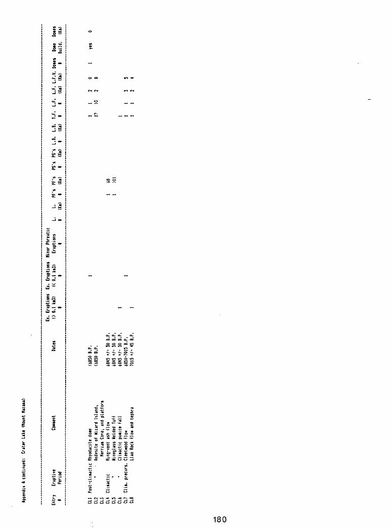
App
tndi
i A
cont
inue
d:
Cra
ter
Lake
(H
ount
Haz
aia)
Ent
ry IE
rupt
ive
Con
ent
Per
iod
Ex.
Eru
ptio
ns
Dat
es
(> 0
.1
ki3)
1
Ex.
Eru
ptio
ns
« 0
.1 k
i3)
1
Nin
or P
hrea
tic
11. 1
L.
PF's
(Ki)
1PF
's
PS's
(Ki)
1PS
's
L.B
.(K
i) 1
L.B
. T.
F.
L.F
.(K
i) 1
1L.
F.
L.F.
V.
Dot
es(K
i) (K
i) I
Bui
ld.
(Ki)
CL1
Post
-chia
ctic
R
hyod
acite
doi
eCL
2 '
A
ndes
ite o
f W
izar
d Is
land
,CL
J H
err
iai
Cone
, an
d p
latf
ori
CL4
Chia
ctic
R
ing-
vent
as
h flo
wCL
5 '
Win
egla
ss W
elde
d Tu
ffCL
6 '
Clii
act
ic p
uiic
e f
all
CL7
Clu
. pr
ecur
s.
Cle
etno
od
flow
CLB
Llao
Roc
k flo
w a
nd t
ephr
a
<66S
O B.
P.
<685
0 B.
P.
6845 +
/- 5
0 B.P.
6845 *
/- 5
0 B.
P.
6845 »
/- 5
0 B.
P.
6850-7015
B.P.
70
15 »
/- 4
5 B.
P.
60
Ml
yes
00 o
Appendii A
continued!
Crater L
ake
(Mount N
azai
a)
Entr
y Re
f.
I CL1
Baco
n, 1983;
1986
, writ
ten
cowu
nica
tion
.CL2
Baco
n, 19
83;-
1986
, written
cowunication.
CL3
CL4
Baco
n, 19B3.
CL5
Baco
n, 19
B3.
CL6
Baco
n, 19
B3.
CL7
Baco
n, 19
B3,
1985.
CLB
Baco
n, 19B3,
1985;
1986,
writ
ten
cont
inua
tion
; Da
vis,
19
78,
1985;
Blintan
and
others,
1979
; Ha
ck a
nd o
ther
s, 1979.
00
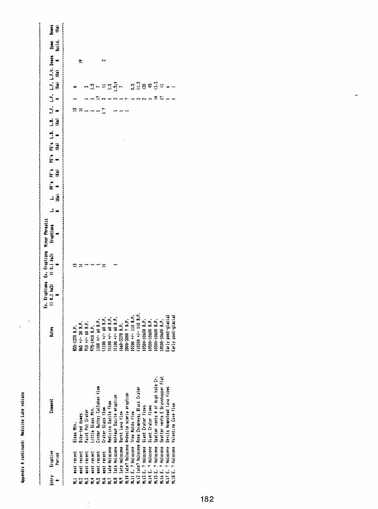
Appe
ndix
A c
onti
nued
: Medicine L
ake
volc
ano
Ent
ry
Eru
ptiv
e1
Per
iod
fill
tost
re
cent
NL2
tost
re
cent
NL3
lost
rec
ent
HL4
lost
re
cent
NL5
lost
re
cent
HL6
tost
re
cent
HL7
late
Hol
ocen
eHL
8 la
te H
oloc
ene
W.9
la
te H
oloc
ene
HL10
lat
e? H
oloc
ene
RL11
E.
? H
oloc
ene
NL12
lat
e? H
oloc
ene
NL13
E.
? H
oloc
ene
HL14
E. '
Hol
ocen
eHL
15 E
. ?
Hol
ocen
efill 6
E.
? H
oloc
ene
KL17
E.
? H
oloc
ene
m.1
8 E.
?
Hol
ocen
e
00 N>
Coi
ient
Gla
ss H
tn.
Dik
e-fe
d do
ies
Pai
nt
Pot
Cra
ter
Little
61
ass
Htn
.C
inde
r B
utte
; C
alla
han
flow
Cra
ter
Gla
ss
flow
Ned
icin
e D
acite
H
owH
oHia
n D
acite
eru
ptio
nB
urnt
la
va f
low
And
esite
sco
ria e
rupt
ion
Tree
Hol
ds
Ho*
Ross
Chi
iney
s;
Bla
ck
Cra
ter
Eia
nt
Cra
ter
flow
sG
iant
C
rate
r flo
ws
Spa
tter
vent
s N
of
Hig
h ho
le C
r.S
patte
r ve
nts
E G
rass
hopp
er
Fla
tD
evils
Hoi
este
ad
lava
flo
ws
Val
entin
e Ca
ve f
lon
Ex.
Eru
ptio
ns
Ex.
Eru
ptio
ns
Min
or P
hrea
tic
Dat
es
(>0.1
ki3
) «
0.1
k§
3)
Eru
ptio
ns
L.
L.
PF'
s P
F's
PS's
PS
's
L.B
.t
1 II
(K«>
1
(Ki>
1
(Ki)
1
855-
1270
B.P
. >3
865
+/-
50
B.P.
>1
910
*/-
60 B
.P.
197
5-14
10 B
.P.
111
00 +
/- 6
0 B
.P.
1<1
100
+/-
60
B.P.
>1
>110
0 +
/- 6
0 B.
P.M
100
+/-
60
B.P.
1
1660
-327
0 B.
P.20
00-3
000
? B.
P.10
200
*/-
110
B.P.
<102
00 »
/-
110
B.P.
1050
0-10
600
B.P.
1050
0-10
600
B.P.
1050
0-10
600
B.P.
1050
0-10
600
B.P.
Ear
ly p
ost
-gla
cia
lE
arly
po
st-g
laci
al
L.B
. T.
F.
L.F
.(K
i) 1
1
>3
1>1 1
11
11
1?1
? 3 1
1 2
1 1
1 ? 1 2 2 1 >4 1? 1 1
(Ki)
(Ki)
1 B
uild
. (K
i)
6>9
3 1.5 7 <1
2
1.5
1.5;
47 0.5
<1.5
>20 45 <3.5 <1 b 1
Appe
ndix
A
cont
inue
d;
Med
icin
e La
ke v
olca
no
Ent
ry
IR
et.
mi
HL2
KL3
nu «L5
HL6
HL7
HLB
W.9
Don
nelly
-Nol
an,
Don
nelly
-Nol
an,
Don
nelly
-Nol
an,
Hei
ken,
19
78.
Don
nelly
-Nol
an,
Don
nelly
-Nol
an,
Bill
er,
C.
D
., M
ille
r,
C.
D.,
Don
nelly
-Nol
an,
flllO
Don
nelly
-Nol
an,
«L11
C
haip
ion,
D.
E.
HL
12 C
haip
ion,
D.
E.
HL
53 C
haip
ion,
D
.E.,
HIM
C
haip
ion,
D
.E.,
HI 15
Don
nelly
-Nol
an,
HL16
Cha
ipio
n,
D.E
., HL
17
Don
nelly
-Nol
an,
HL18
Don
nelly
-Nol
an,
J.
H.,
1986
, w
ritten c
on
un
ica
tion
.J.
H
., 19
86,
written c
oiiu
nic
atio
n.
L
n.,
1936
, w
ritte
n co
itunic
atio
n.
J.
H.,
1986
, w
ritten c
oiiu
nic
atio
n.
J.
n.,
1986
, w
ritten c
oiiu
nic
atio
n;
Kill
er,
C.
D
., 19
86,
unpu
blis
hed
data
. 19
86,
unpu
blis
hed
data
. 19
86,
unpu
blis
hed
data
.J.
H
., 19
86,
written c
oiiu
nic
atio
n.
L
H.,
1986
, w
ritten c
oiiu
nic
atio
n.
, 19
86,
written c
oinu
nica
tion.
,
1986
, w
ritten c
oiiu
nic
atio
n.
and
Don
nely
-Nol
an,
J.
H.,
1986
, w
ritte
n co
iiunic
atio
n.
and
Don
nely
-Nol
an,
J.
H.,
1986
, w
ritte
n co
iiunic
atio
n.
J.
H.,
1986
, w
ritte
n co
iiunic
atio
n.
and
Don
nely
-Nol
an,
J.
n.,
19
86,
writ
ten
coiiu
nic
atio
n.
J.
H.,
1986
, w
ritte
n co
iiunic
atio
n.
J.
n.,
19
86,
writ
ten
coiiu
nic
atio
n.
00
CO
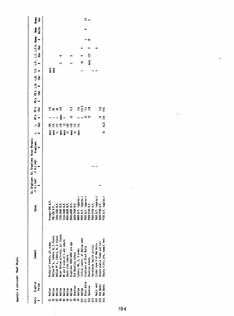
flppe
ndii
A co
ntin
ued:
M
ount
Sn
asta
Ent
ry
1 St S2 S3 54 55 Si
S7 SB S9 S10
Sll
S12
S13
S14
S15
S16
Eru
ptiv
e P
erio
d
Hot
lui
Ho
tlui
Ho
tlui
Hot
lui
Hot
lui
Hot
lui
Ho
tlui
Sha
stin
aH
otlu
iH
otlu
iB
lack
But
teS
hast
ina
Haf
ic
vent
Red
Bank
sRe
d Ba
nks
Cou
ent
His
toric
? ev
ents
, a
ll si
des
Hot
lui
PF'
s,
laha
rs,
N,
E fla
nks
H
otlu
i P
F's
, la
hars
, N,
E f
lank
sH
ajor
Hotlu
i a
ctivity,
all
Han
ksNE
and
E
side
pfs
and
la
hars
Sout
h si
de l
ahar
sE
rupt
ions
500
0-60
00 y
rs a
goO
ld S
hast
ina
laha
rsLa
hars
, NE
, E,
S
side
sIn
itia
l co
nstr
. of
H
otlu
i co
neE
rupt
ions
at
Bla
ck B
utte
Sha
stin
a ev
ents
Hor
nble
nde
daci
te a
irfa
llC
inde
r co
ne S
of
Red
But
teSh
asta
pui
ice
floiis
and
fa
llSh
asta
tithic
pfs
, su
uit v
ent
Ex.
Eru
ptio
ns
Ex.
Eru
ptio
ns
Hi n
or P
hrea
tic
Dat
es
(> 0
.1
ki3)
«
0.1
ki3
) E
rupt
ions
L.
I
1 II
Pre
sent
-200
B.P
.70
0-75
0 B.
1000
-150
017
00-3
000
3100
-340
040
00-4
500
5000
-600
060
00-7
000
8000
B.P
.90
00 B
.P.
9500
B.P
.95
00-9
700
9500
-970
096
00 B
.P.
9600
-970
097
00 B
.P.
P. B.P.
B.P.
B.P.
B.P.
B.P
.B.
P.(a
ppro
x.l
(app
rox.
l(a
ppro
x.)
B.P
.B.
P.
1(a
ppro
x.)
1B.
P.
1(a
ppro
x.)
any
any >1 any
any >3 any >2 any >3
L.
Pfs
(K
«)
1
>24
1>1
4 1
Ml
1>1
5 ta
ny13
1
>30
MB
>2>1
5>1
6 1 1 >3 >5 >4
>6.5
>1
0
PF'
s P
S'i
PS's
(K
i) 1
(U>
>12
>B >B >18
9.5
>16
M0.
5>1
1>1
8
MO
<=21
L.B
. L.
B.
T.F.
L.
F.
L.F
. L.
F.V
. D
oaet
Do
«e
Dot
es1
(Ki)
1 1
(Ki)
(Ki)
1 B
uild
. (K
i)
any
any
2 5
2 5
1 >5
9
91
4 14
any
>1
3 2
>5
21 1
6
00
Appendii A
con
tinu
ed)
Haunt
Shas
ta
00
Ol
Ent
ry
tR
ef.
51
Kil
ler,
19
80.
52
Kil
ler,
19
80.
53
Kil
ler,
19
80:
54
Kil
ler,
19
80.
S3
Kil
ler,
19
80.
Si
Kil
ler,
19
80.
S7
Kil
ler,
19
80.
S3
Kil
ler,
19
80.
59
Kil
ler,
19
80.
510
Kil
ler,
19
80.
511
Kil
ler,
19
BO.
512
Kil
ler,
19
80.
513
Kil
ler,
19
80.
514
Kil
ler,
19
80.
515
Kil
ler,
19
80.
Sli
K
ille
r,
1980
.
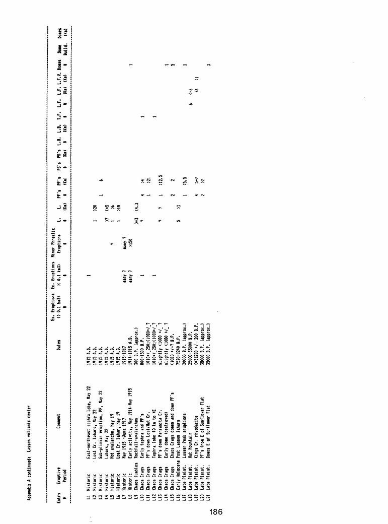
Appe
ndix
A c
ontin
ued!
(.m
en v
olca
nic
cent
er
Ent
ry 1 Li 17 13 I* L5 L4 L7 LB L9 L10
Lit
L12
L13
LI4
LI5
L16
L17
LIB
LI9
L20
_L
L21
CO
CD
Eru
ptiv
eP
erio
d
His
toric
His
toric
His
toric
His
toric
His
toric
His
toric
His
toric
His
toric
Chao
s Ju
ibte
sCh
aos
Cra
gsCh
aos
Cra
gsCh
aos
Cra
gsCh
aos
Cra
gsCh
aos
Cra
gsCh
aos
Cra
gsE
arly
Hol
ocen
eLa
te P
leis
t.La
te P
leis
t.La
te P
leis
t.La
te P
leis
t.La
te P
leis
t.
Cou
ent
Eas
t-no
rthe
ast
teph
ra
lobe
, Ha
y 22
Lost
C
r. la
hars
, Ha
y 22
Sub-
pi in
ian
erup
tion,
PF
, Ha
y 22
Laha
rs,
Nay
22Ho
t av
alan
che,
Ha
y 19
Lost
Cr.
lahar,
Hay
19
Hay
1915
-Ju
ne
1917
Ear
ly a
ctivity,
Nay
1914
-Hiy
19
15R
ockf
all-a
vala
nche
sE
arly
tep
hra
and
PF'
sPF
's d
own
Lost
/Hat
Cr.
Teph
ra
lobe
40
ki
to H
EP
F's
doiin
Han
zani
ta C
r.E
arly
doi
e (d
estro
yed)
Chao
s C
rags
doi
es a
nd d
oie
PF'
sPo
st
Lass
en
laha
rsLa
ssen
Pe
ak e
rupt
ions
Hat
Mou
ntai
nKi
ngs
Cr.
rhyo
daci
teP
F's
fro
i E
of
Sun
flow
er
Fla
tD
oies
E o
f S
unflo
wer
Fla
t
Ex.
Eru
ptio
ns
Ex.
Eru
ptio
ns
Min
or P
hre
itic
Dat
es
(> 0
.1
ki3)
«
0.1
ki
3)
Eru
ptio
ns
L.I
1 I
i
1915
A.D
. 1
1915
A.D
. 1
1915
A.D
.19
15 A
.D.
>719
15 A
.D.
? 1
1915
A.D
. 1
1915
-191
7 ia
ny ?
ta
ny ?
1914
-191
5 A.
D.
iany
?
>150
300
B.P.
(a
ppro
x.)
>=3
800-
1500
B.P
. 1
?10
10+/
_250
;<10
80+/
.?10
10+/
_250
;<10
80+/
1?
1sl
ightly
<10
80 +
/_ ?
?
slig
htly
U08
0 +
/. ?
<10B
O +/
-? B
.P.
7520
-824
0 B.
P.
520
000
B.P.
(a
ppro
x.)
2500
0-35
000
B.P.
(=31
280
+/-
200
B.P
.35
000
B.P.
(a
ppro
x.)
3500
0 B.
P.
(app
rox.
)
L.
PF'
s P
F's
PS's
PS
's
L.B
. L.
B.
T.F.
L.
F.
L.F.
L.
F.V
. D
om
DOM
D
ues
(Ki)
i (K
i) I
(Ka)
I
(Ki)
I I
(Ka)
(K
i) I
Bui
ld.
<* >
>20
1 6
<=5 >6 >18
1<4
.34
>4
11
>21
1?
1 M
2.5
12
2 5
>31
>5.5
1
6 <=
64
5-7
>3
<12
>23
App
tndi
i A
cont
inue
d:
Lais
en v
olca
nic
ctnttr
Ent
ry
Ref
. I Li
Chri
stia
nsen
and C
lynne, 1986;
Clynne,
fl.,
1986,
written
coMuni
cati
on;
Day
and
Alie
n, 1
925.
L2
Chri
stia
nsen
and
Clynne, 1986;
Day
and
Alie
n, 1925.
L3
Chri
stia
nsen
and
Clynne, 1986;
Day
and
Alie
n, 1925.
L4
Chri
stia
nsen
and
Clynne, 1986;
Clynne,
H.,
1986,
written
conu
nica
tion
.L5
Day
and
Alie
n, 19
25;
Clynne,
H.,
1986
, written
continuation.
L6
Clynne,
H.,
1986,
written
coMu
nica
tion
.L7
Day
and
Alie
n, 1925.
L8
Day
and
Alie
n, 19
25;
Christiansen a
nd C
lynne, 1986.
L9
Cran
dell
and
others, 19
74.;
Cly
nne,
H., 1986,
written
coMu
nica
tion
.L10
Crandell a
nd o
thers, 19
74;
Clynne,
N.,
1986
, written
conu
nica
tion
.Il
l Heiken a
nd E
ichelberger, 19
80;
Clyn
ne,
N.,
1986,
written
conu
nica
tion
.L12
Clyn
ne,
H.,
1966,
written
conunication.
L13
Heiken a
nd E
ichelberger, 19
80;
Clyn
ne,
H.,
1986,
written
conuni
cati
on.
114
Clyn
ne,
H.,
19B6,
written
conu
nica
tion
.L15
Cran
dell
and
others, 19
74;
Clyn
ne,
H.,
1986
, written
conu
nica
tion
.L16
Clynne,
H.,
1986
, written
conu
nica
tion
.L17
Cran
dell
and
Hul
line
aux,
19
70;
Clynne,
H.,
1986,
written
conu
nica
tion
.L18
Clynne,
H.,
1966,
written
conu
nica
tion
.L19
Clynne,
n.,
1986
, written
conu
nica
tion
._L
L20
Cnnd
ell
and
Null
inea
ux,
1970
; Triable
and
others,
1984.
00
L21
Cran
dell
and
Hullineaux, 1970;
Clyn
ne,
n.,
1986,
written
conu
nica
tion
.
Appe
ndix
A co
ntin
ued:
B
asal
tic v
olca
noes
and
vol
cani
c fie
lds
ot t
he C
asca
de R
ange
00 00
Entr
y Conent
1
HASH
IN6T
ON 8
ASALTIC
VOLC
ANOE
SBS1
Big
Lava
Bed;
Indi
an H
eaven
fiel
dBS2
T*in B
utte
s; In
dian
Heaven
fiel
dBS3
Sout
h Red
nt.;
In
dian
Heaven
fiel
d
OREGON B
ASALTIC
VOLCANOES
BS4
Scoria c
one
south
of T
he T
able
BS5
Forked B
utte
BS6
Forked B
utte
BS7
Jefferson
Creek
BS8
South
flan
k of S
outh C
inder
Peak
BS9
Sand
-Nas
h-Lo
st L
ake
fiel
dBS
10
Sand-Nash-Lost L
ake
field
BS11
Blue L
ake
Crater
BS12
Sp
atte
r Co
ne C
hain
BS13
In
acce
ssib
le C
one
BS14
Be
lknap
Crat
er (shield
volc
ano)
BS15
So
uth
Belknap
Cone
BS16
Li
ttle B
elknap
BS17
Tw
in C
rate
rsBS
18
Yapoah C
one
BS19
Yapoah C
one
BS20
Four-in-One
Cone
BS21
Coll
ier
Cone
BS22
Co
llier
Cone
BS23
Coll
ier
Cone
BS24
Le C
onte C
rater
BS25
Le
Conte C
rater
BS26
Cayuse C
rater
BS27
Cayuse C
rater
BS28
Katsuk a
nd T
alapus B
uttes
BS29
Re
d Cr
ater
chain o
f vents
BS30
Co
ne o
n N
flan
k of
nt. Bachelor
BS31
nt.
Bach
elor
suu
it c
one
BS32
nt.
Bachelor s
hield
volcano
BS33
nt.
Bachelor s
hield
volcano
BS34
Cones
alon
g So
da C
reek
BS35
Kn
olli
Butte s
hiel
d volc
ano
BS36
Sh
eridan n
t. shield v
olcano
BS37
Siah
Butte c
hain
of
vents
BS38
Si
ah B
utte
cha
in o
f vents
£S39
Si
ah B
utte c
hain o
f vents
BS40
Hu
ksi-
Pala
nush
-Shu
kash
-Twi
n La
kes
BS41
Davis
Lake
lava
flow
BS42
Black
Rock
BS43
Black
Rock
Butte
BS44
Little O
dell
Butte
Devils G
arden
Squa
t* R
idge
Four C
rate
rs
Ex.
Erup
tion
s Dates
(> 0
.1 k
i3)
1
500-3500 B
.P.
3500
-12,
000
B.P.
3500
-12,
000
B.P.
6500
B.P
. (a
ppro
x.65
00 B
.P.
(app
rox.
6500 B
.P.
(approx.
6500
B.P.
(approx.
1000 B
.P.
(approx.
2705
+/-
200 t
hru
>3850
+/-
215
B.P.
3440
+/-
250
B.P
.34
40 B
.P.
(approx.)
2705
-12,
000
B.P.
1590
+/-
160
thr
u >2883
B.P.
1775
+/-
400
B.P
.28
83 +
/- 1
75 B
.P.
2600
B.P.
(app
rox.
)2550-2883
8. P.
2550
-288
3 B.
P.25
50 *
/- 1
65 B
.P.
1600
+/- 1
00 B
.P.
1600
»/- 1
00 B
.P.
1600
+/- 1
00 B
.P.
6850-15000 B
.P.
6850-15000 B
.P.
9500-12000 B
.P.
9500-12000 B
.P.
15000
B.P. (approx.)
1500
0 B.P. (a
ppro
x.)
7000-11000 B
.P.
1100
0-13
000
B.P.
1100
0-13
000
B.P.
1100
0-13
000
B.P.
1200
0-15
000
B.P.
11000-15000
1500
0 (a
ppro
x.)
1300
0-15
000
B.P.
13000-15000
B.P.
1300
0-15
000
B.P.
6850-15000 B
.P.
<6850
B.P.
<6850
B.P.
<685
0 B.P.
6850-15000?
B.P.
Holocene
Holocene
Holo
cene
Ex.
Eruptions
Minor
Phreatic
« 0
.1 k
i3)
Eruptions
L.
L.
PF's
PF's
PS's
PS'f
L.B.
I.B
I It
(Ki)
1
(Ki)
1 (k
i)
1 (K
i
1 1 1 1 1 1 1 a
ny 1 iany
?1 M any 1 1 1
2
>1 1 1 3 >1
«any
?>1 >1 any 1
any
any
any
1
any
any
any
>5
iany?
1 1 1 1 1? 1? 1?
T.F. I 1? 1 1 1 1 1 1 any 1 1? >1 any 1 1 1 1 1 1 1 1 M? 1 any 1 any
any
any
any
any
any 1 1 1 1 1? 1? 1?
I.F. 1 1 1 1 1 1 >6 4 >2 1 10's
lO'i 1 1 2 6 1 1 2 1 2 1 1 1 2 1 10's
10's
10's 7 10's
10's
>30
MO MO any 1 1 1 1 any
any
any
L.F. L
.F.V
. Doies
Doie
s Do
tes
(Ki)
(ki)
I
Build.
(Ki)
15 9 3 12 5 7 3 >2 17 7 3 3 13 5 3 14 4 1 7 5
4 4 1 5 3 4 4 10 5 9 8 7 5 3 3 3 3 1.5 3 17 6
I4
Appe
ndix
A co
ntin
ued:
B
asal
tic v
olca
noes
and
vol
cani
c fie
lds
of t
he C
asca
de R
ange
t
8545
Thirsty
Point
B546
Cinn
aion
But
te
Date
s
6850
-150
00?
8. P.
6B
50- 1
5000
? B.
P.
Ex.
Erup
tion
s (>
0.1
ki3)
t
Ex.
Erup
tion
s « 0
.1 k
i3)
t 1 1
Minor
Phreatic
Eruptions
L.
L.
PF's
PF'i
PS's
PS's
L.B.
t t
(Ki)
t
(Ki)
t
(ki)
tL.B.
T.F.
L.F.
(Ki)
t t
1 1
1 la
ny
1
L.F.
L.F
.V.
Dotes
Doies
(Ki)
(k
i)
t Bu
ild.
7 5
(Ki)
CALI
FORN
IA B
ASAL
TIC
VOLC
ANOE
S BS
47
Shi
eld
volc
ano
north
of
Big
Lake
BS
4B
FloH
nor
th o
f Ba
ld M
ount
ain
BS«9
C
inde
r B
utte
BS5Q
Tm
n B
utte
s;
east
of
Burn
ey H
I. BS
51
Ande
s!te
of
Dev
ils R
ock
Gar
den
BS52
B
asal
t of
Hat
Cre
ek v
alle
y B5
53
Flo*
; ea
st b
ase
of M
Pro
spec
t Pk
Cin
der
Cone
Late
st P
leis
t-H
olo
Late
st P
leis
t-Hol
o La
test
Ple
ist-H
olo
Late
st P
leis
t-Hol
o La
test
Ple
ist-H
olo
Late
st P
leis
t-Hol
o La
test
Ple
ist-H
olo
15i7
? th
ru?
1851
A.D
.
00
CO
Appe
ndix
A c
onti
nued
! Basaltic v
olcanoes a
nd v
olcanic
fiel
ds o
f the
Casc
ade Range
Entr
y Re
f.
I
WASHINGTON BASALTIC
VOLC
ANOE
S 8S
1 Ha
uond
, i9
60.
BS2
Hauo
nd,
i960
. BS
3 Ha
uond
, 1980.
OREG
ON BASALTIC
VOLCANOES
BS4
Sutton,
1974
; Sc
ott,
19
77;
Scot
t, U. E.,
unpublished
data.
BS5
Scot
t, 1977.
BS6
Scott, 1977.
BS7
Scot
t, 1977.
BS8
Scott, 19
77.
BS9
Tayl
or,
1965;
Taylor,
1981.
BSIO
Taylor,
1965
.BS
11
Tayl
or,
1965
.BS
12
Taylor,
1965.
BS13
Taylor,
1965.
BS14
Taylor,
1965
; 19
B1.
BS15
Ta
ylor
, 1965;
1981
.BS
16
Taylor,
1965
; 1981.
BS17
Taylor,
1965;
1981
.BS
18
Tayl
or,
1965;
1981.
BS19
Taylor,
1965;
1981
.PS
20
Tayl
or,
1965;
1981.
-»
BS21
Taylor,
1965
; Sc
ott,
«.
E.
, un
publ
ishe
d da
ta.
~
BS22
Ta
ylor
, 1965;
Scott, «
. E.,
unpu
blis
hed
data.
BS23
Ta
ylor
, 19
65;
Scot
t, K.
E.,
unpu
blis
hed
data.
BS24
Clark
(198
3);
Scott
(19B6; in p
ress); Sc
ott,
M.
E.,
and
Gardner, C
. A. (u
npub
lish
ed d
ata)
BS25
Clark
(198
3);
Scott
(198
6; in p
ress); Scott, M.
E.,
and
Gardner, C. A. (unpublished d
ata)
BS26
Tayl
or,
1978;
Scot
t, 1987;
Scot
t, M. E.,
and
Gard
ner,
C.
A.,
unpublished
data.
BS27
Tayl
or,
1978;
Scot
t, 1987;
Scot
t, H. E.,
and
Gard
ner,
C.
A.,
unpu
blis
hed
data.
BS2B
Sc
ott,
N.
E.
, an
d Ga
rdne
r, C
. A.,
unpublished
data
.BS29
Scot
t, U.
E.
, and
Gard
ner,
C.
A.,
unpublished
data.
BS30
Sc
ott,
M. E.,
and
Gard
ner,
C.
A.,
unpublished
data.
BS31
Ta
ylor
, 1978;
Scot
t and
Gard
ner,
1985;
Scot
t, M. E.,
and
Gard
ner,
C.
A.,
unpu
blis
hed
data.
BS32
Taylor,
1978;
Scot
t and
Gard
ner,
1985;
Scot
t, M. E.,
and
Gard
ner,
C.
A.,
unpublished
data.
BS33
Ta
ylor
, 19
78;
Scott
and
Gard
ner,
19
85;
Scot
t, M
. E.,
and
Gard
ner,
C.
A.,
unpu
blis
hed
data.
BS34
Ta
ylor
, 19
78;
Scot
t, M
. E.,
and
Gardner, C.
A.,
unpublished
data.
BS35
Scott
and
Gard
ner,
19
85;
Scot
t, H.
E.,
and
Gard
ner,
C.
A.,
unpu
blis
hed
data.
BS36
Scott
and
Gard
ner,
19
85;
Scot
t, M. E.
, an
d Ga
rdne
r, C
. A.,
unpublished
data.
BS37
Scott
and
Gard
ner,
1985;
Scot
t, M.
E.,
and
Gard
ner,
C.
A.,
unpublished
data
.BS!B
Scott
and
Gard
ner,
19
85;
Scot
t, M. E.
, an
d Ga
rdne
r, C
. A.,
unpu
blis
hed
data.
BS39
Scott
and
Gard
ner,
1985;
Scot
t, M.
E., an
d Ga
rdne
r, C. A.,
unpublished
data.
BS40
Sc
ott,
M.
E.,
and
Gard
ner,
C. A.,
unpu
blis
hed
data.
BS41
Sh
erro
d, 19
86;
Scot
t,
U. E.,
unpublished
data
.BS42
Sher
rod,
1986;
Scot
t, W. E.,
unpublished
data.
BS43
Sh
erro
d, 1986;
Scot
t, M. E.
, unpublished
data.
BS44
Scot
t, H
. E.,
unpublished
data
.Pe
ters
on and
Gro
h, 1963;
Milker a
nd o
ther
s, 1967.
Pete
rson
and G
roh, 1963;
Walk
er a
nd o
ther
s, 1967.
Peterson and
Gro
h, 19
63,
1964;
Milker a
nd o
ther
s, 19
67.
Appe
ndix A
con
tinu
ed:
Basaltic v
olcanoes a
nd v
olcanic
fiel
ds o
f the
Casc
ade
Range
Entr
y Re
f.I
BS45
S
herr
od,
1986
. BS
46
She
rrod
, 19
86.
CALI
FORN
IA B
ASAL
TIC
VOLC
ANOE
S BS
47
Kill
er,
C.
D
., un
publ
ishe
d da
ta.
BS48
S
iith
and
Lued
ke,
1983
. BS
49
Hitl
er,
C.
D
., un
publ
ishe
d da
ta.
BS50
H
itle
r,
C.
D.,
unpu
blis
hed
data
. BS
51
Hac
Don
ald,
19
63.
BSS2
An
ders
on,
1940
; tta
cDon
ald,
19
64.
BS53
H
acD
onal
d,
1964
.M
iltia
is,
1928
; Fi
nch,
19
37;
Hac
Don
ald,
19
64;
Cly
nne,
H.
A,
19
86,
writ
ten
con
tinu
atio
n.
CO
APPENDIX B: Glossary
Andesite:
Ash (volcanic):
Ash cloud:
An extrusive volcanic rock of intermediate silica content (58-63 %) and intermediate viscosity when in a molten state.
Fragments of lava or rock smaller than 2 mm in size that are blasted into the air by volcanic explosions.
Cloud of volcanic ash formed by volcanic explosions or derived from a pyroclastic flow.
Atmospheric shock wave:
Basalt:
Ballistic fragment
Basaltic andesite:
Base surge:
Block:
Caldera:
Cinder cone:
Strong compressive atmospheric wave driven by volcanic ejecta.
An extrusive volcanic rock with a low silica content (< 53 %) and a low viscosity when in a molten state.
An explosively ejected rock fragment that follows a ballistic trajectory.
An extrusive volcanic rock with a silica content of 53-58 %. Viscosity when molten is intermediate between that of basalt and andesite.
Turbulent, low-density cloud of rock debris and water and (or) steam that moves over the ground surface at high speed.
Fragment of lava or rock larger than 64 mm in size that is blasted into the air by volcanic explosions.
A large volcanic collapse depression, more or less circular in form, with a diameter of one kilometer or more.
A conical landform composed of unconsolidated volcanic cinders, usually basalt or basaltic andesite in composition.
192
Composite volcano:
Conduit (volcanic)
Dacite:
Debris avalanche (volcanic):
Dike:
Dome:
Early Pleistocene
Fumarole:
Fission-track dating:
Glacier outburst flood:
Holocene:
Hydrothermal:
Igneous:
K-Ar dating:
A volcano that is composed of alternating layers of lava and pyroclastics. Synonymous with stratovolcano.
A subterranean passage through which magma reaches the surface during volcanic activity
An extrusive volcanic rock intermediate in silica content (63-68 %) and viscosity between that of andesite and rhyolite.
Flowing or sliding mixture of soil and rock debris, with or without water, that moves away from a volcano at high speed.
A tabular igneous body that cuts across the planar structures of the surrounding rocks.
A steep-sided mass of viscous lava extruded from a volcanic vent.
Part of the Pleistocene Epoch between 1.8 million and 730,000 years ago.
An opening in the ground from which hot water vapor and/or volcanic gases are emitted.
A method of calculating an age in years of an igneous rock by determining the ratio of spontaneous fission-track density to induced fission tracks.
Flood generated by the sudden release of water from a glacier.
Period of geologic time from about 10,000 years ago until the present.
Of or pertaining to heated water, or to the products of the action of heated water.
Solidified from a magma; also applied to processes related to the formation of igneous rocks.
Determination of the age of a mineral or rock in years based on the known radioactive decay rate of potassium-40 to argon-40.
193
Lahar:
Lahar-runout flow:
Lapilli:
Late glacial:
Late Pleistocene:
Late Quaternary:
Late Wisconsin:
Lateral blast:
Lava flow:
Lithic (volcanic):
Loess:
Mafic:
Magma:
A mixture of water-saturated rock debris that flows downslope under the influence of gravity from a volcano.
Hyperconcentrated streamflow transitional in sediment concentration between a lahar and normal streamflow.
Fragments of lava or rock between 2 and 64 mm in size that are blasted into the air by volcanic explosions.
Time period between about 20,000 and 15,000 years ago.
Part of the Pleistocene Epoch between 125,000 and 10,000 years ago.
Time period between about 20,000 years ago and the present.
Period of glacier expansion that, in the Cascades, culminated between about 22,000 and 18,000 years ago and ended between about 14,000 and 12,500 years ago.
A hot, low-density mixture of rock debris, ash, and gases that moves at high speed along the ground surface.
Stream of molten rock that erupts relatively nonexplosively from a volcano and moves slowly downslope.
Pertains to pyroclastic deposits that contain abundant fragments of previously-formed rocks and/or dense fragments.
A well-sorted deposit of windblown silt-sized particles that forms a blanket over the landscape.
An igneous rock composed chiefly of one or more ferromagnesian {iron-magnesium-rich), dark-colored minerals.
Molten or partly molten rock material generated within the Earth.
194
Magnetic polarity:
Middle Pleistocene
Moraine:
Phreatic eruption:
Pleistocene:
Pluton:
Poisson distribution
Postglacial:
Pumice:
Pyroclastic:
Pyroclastic flow:
Pyroclastic surge:
Direction of magnetic poles (either normal or reversed) preserved in igneous rocks after they cool through their Curie temperatures.
Part of the Pleistocene Epoch between about 730,000 and 125,000 years ago.
A mound, ridge, or other accumulation of unsorted, unstratified debris deposited by the direct action of glacier ice.
An explosion of steam, water, mud, and other material. May result from heating of groundwater by magma, and may generate base surges.
An Epoch of geologic time between about 1.8 million and 10,000 years ago.
Pertaining to igneous rock bodies that form at great depth.
A discrete frequency distribution based on the assumptions that (1) the events occur independently, (2) the probability of an event is independent of the time elapsed since the last event, and (3) the probability that two events will occur at the same time is vanishingly small.
Refers to the time since the last major glaciation, about the last 12,000 to 15,000 years.
A highly vesicular, frothy natural glass with a high silica content formed through volcanic activity.
A general term applied to volcanic material which has been explosively ejected from a vent.
High-density mass of hot, dry rock fragments mixed with hot gases, that moves away from a volcano at high speed.
Turbulent low-density cloud of hot rock debris and gases that moves over the ground surface at high speed.
195
Quaternary:
Rhyolite:
Satellite vent:
Scoria:
Seismicity:
Shield volcano:
Silicic:
Stratovolcano:
Tectonic:
Tephra:
Tuff:
Period of time that includes the Pleistocene and Holocene Epochs, about the last 1.8 million years.
An extrusive volcanic rock that has a high silica content (> 68 %) and very high viscosity when molten.
A secondary vent or flank vent at a volcanic center.
Vesiculated fragments of basalt or basaltic andesite.
Pertaining to earthquakes or earth vibration.
A volcano in the shape of a flattened dome. It is broad and low and is built of low- viscosity basaltic lava.
Term used to describe silica-rich volcanic rock or magma.
A volcano that is composed of alternating layers of lava and pyroclastics. Synonymous with composite volcano.
Pertaining to the forces involved in the deformation of the Earth's curst, or the structures or features produced by such deformation.
Materials of all sizes and types that are erupted from a volcano and deposited from the air.
Used loosely as a collective term for all consolidated pyroclastic rocks.
196