Embed Size (px)
Citation preview
Kidanemariam Jembere, Technical Advisor, GWP Africa Coordination Unit
Vulnerability Assessment and Options Appraisal in Developing an Adaptation Program in Uganda
(water resources management system)
Presentation for LEG Regional Training on NAPs27 February-3 March 2017, Lilongwe, Malawi
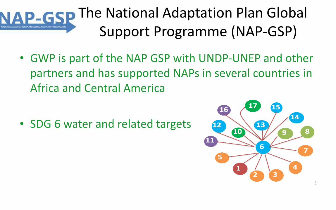
The National Adaptation Plan Global Support Programme (NAP-GSP)
• GWP is part of the NAP GSP with UNDP-UNEP and other partners and has supported NAPs in several countries in Africa and Central America
• SDG 6 water and related targets
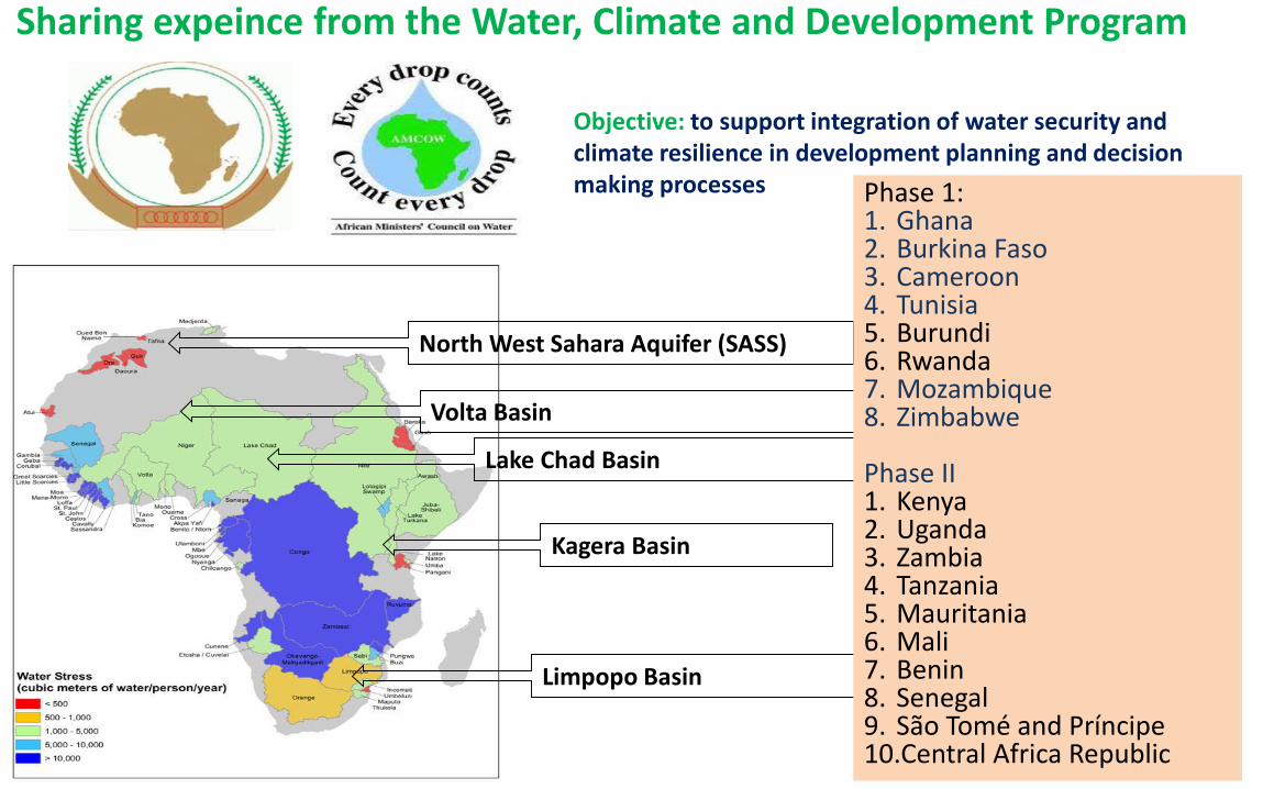
North West Sahara Aquifer (SASS)
Volta Basin
Lake Chad Basin
Limpopo Basin
Kagera Basin
Sharing expeince from the Water, Climate and Development Program
Phase 1:1. Ghana 2. Burkina Faso3. Cameroon 4. Tunisia5. Burundi6. Rwanda7. Mozambique8. Zimbabwe
Phase II1. Kenya2. Uganda3. Zambia4. Tanzania5. Mauritania6. Mali7. Benin8. Senegal 9. São Tomé and Príncipe10.Central Africa Republic
Objective: to support integration of water security and climate resilience in development planning and decision making processes
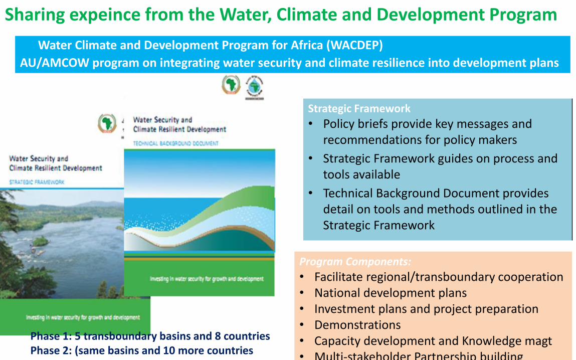
Water Climate and Development Program for Africa (WACDEP)
AU/AMCOW program on integrating water security and climate resilience into development plans
Sharing expeince from the Water, Climate and Development Program
Strategic Framework
• Policy briefs provide key messages and recommendations for policy makers
• Strategic Framework guides on process and tools available
• Technical Background Document provides detail on tools and methods outlined in the Strategic Framework
Program Components:
• Facilitate regional/transboundary cooperation• National development plans • Investment plans and project preparation• Demonstrations• Capacity development and Knowledge magt• Multi-stakeholder Partnership building
Phase 1: 5 transboundary basins and 8 countriesPhase 2: (same basins and 10 more countries
Vulnerability Assessment and Options Appraisal in Developing an Adaptation Program in Uganda
(water resources management system)
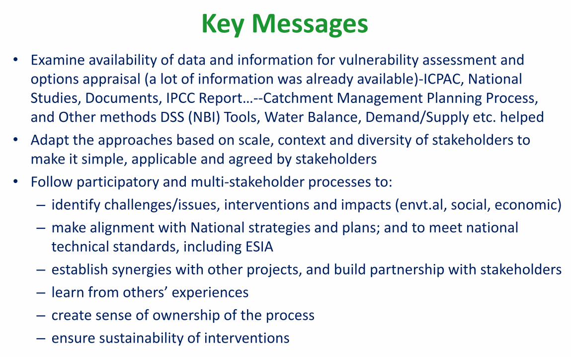
Key Messages• Examine availability of data and information for vulnerability assessment and
options appraisal (a lot of information was already available)-ICPAC, National Studies, Documents, IPCC Report…--Catchment Management Planning Process, and Other methods DSS (NBI) Tools, Water Balance, Demand/Supply etc. helped
• Adapt the approaches based on scale, context and diversity of stakeholders to make it simple, applicable and agreed by stakeholders
• Follow participatory and multi-stakeholder processes to:
– identify challenges/issues, interventions and impacts (envt.al, social, economic)
– make alignment with National strategies and plans; and to meet national technical standards, including ESIA
– establish synergies with other projects, and build partnership with stakeholders
– learn from others’ experiences
– create sense of ownership of the process
– ensure sustainability of interventions
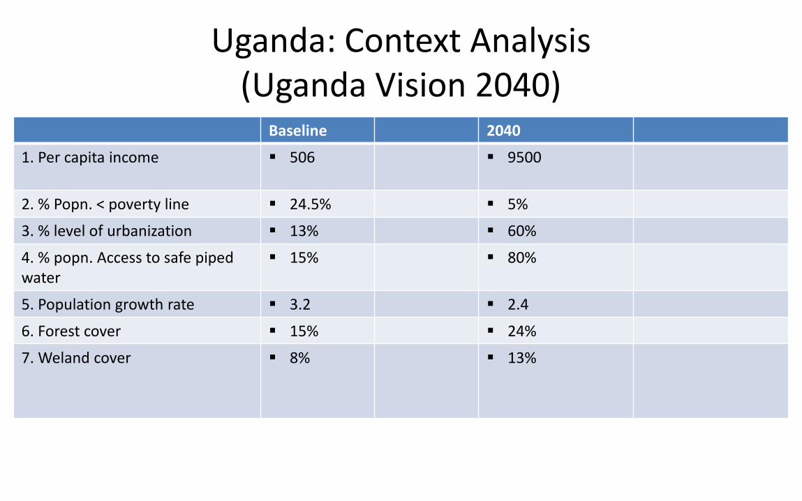
Uganda: Context Analysis(Uganda Vision 2040)
Baseline 2040
1. Per capita income 506 9500
2. % Popn. < poverty line 24.5% 5%
3. % level of urbanization 13% 60%
4. % popn. Access to safe pipedwater
15% 80%
5. Population growth rate 3.2 2.4
6. Forest cover 15% 24%
7. Weland cover 8% 13%
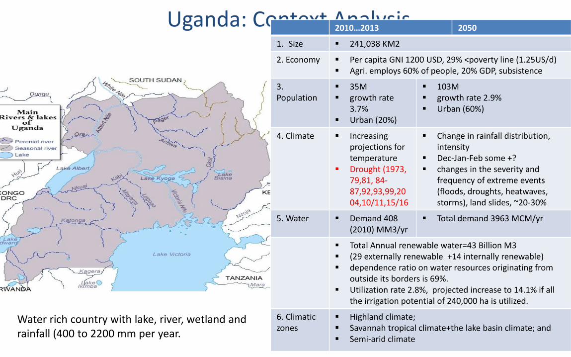
Uganda: Context Analysis2010…2013 2050
1. Size 241,038 KM2
2. Economy Per capita GNI 1200 USD, 29% <poverty line (1.25US/d) Agri. employs 60% of people, 20% GDP, subsistence
3. Population
35M growth rate
3.7% Urban (20%)
103M growth rate 2.9% Urban (60%)
4. Climate Increasingprojections for temperature
Drought (1973, 79,81, 84-87,92,93,99,2004,10/11,15/16
Change in rainfall distribution, intensity
Dec-Jan-Feb some +? changes in the severity and
frequency of extreme events (floods, droughts, heatwaves, storms), land slides, ~20-30%
5. Water Demand 408 (2010) MM3/yr
Total demand 3963 MCM/yr
Total Annual renewable water=43 Billion M3 (29 externally renewable +14 internally renewable) dependence ratio on water resources originating from
outside its borders is 69%. Utilization rate 2.8%, projected increase to 14.1% if all
the irrigation potential of 240,000 ha is utilized.
6. Climatic zones
Highland climate; Savannah tropical climate+the lake basin climate; and Semi-arid climate
Water rich country with lake, river, wetland and rainfall (400 to 2200 mm per year.
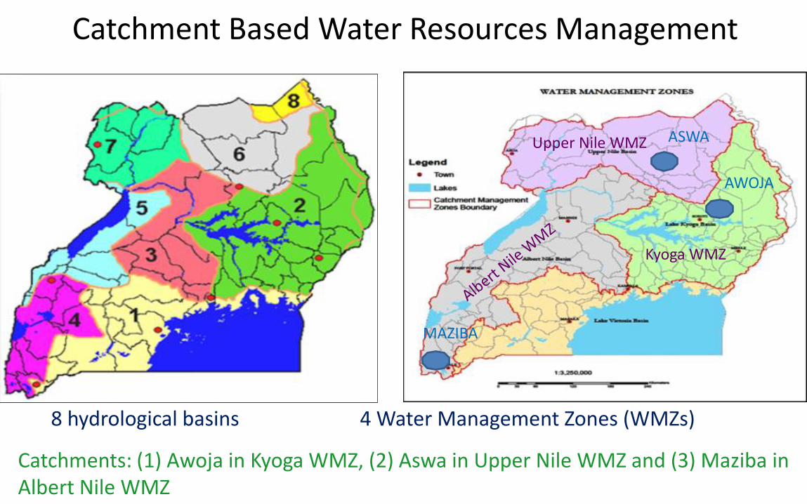
Catchment Based Water Resources Management
8 hydrological basins 4 Water Management Zones (WMZs)
AWOJA
ASWA
MAZIBA
Upper Nile WMZ
Kyoga WMZ
Catchments: (1) Awoja in Kyoga WMZ, (2) Aswa in Upper Nile WMZ and (3) Maziba in Albert Nile WMZ

Catchment selection criteria
• Relative degree of vulnerability to climate change, and severity of other challenges such as land degradation, water scarcity and population pressure
• Sensitivity of ecological systems such as degraded highlands, wetlands, grazing lands/savannah.
• Broader representation of climatic zones of Uganda..
• Representation of diverse livelihood and social systems
Note: Prioritization of catchments done by MWE as part of Catchment Management Planning process.
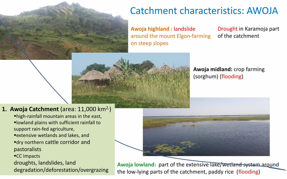
Awoja highland : landslidearound the mount Elgon-farming on steep slopes
Awoja midland: crop farming (sorghum) (flooding)
Awoja lowland: part of the extensive lake/wetland system around the low-lying parts of the catchment, paddy rice (flooding)
Drought in Karamoja part of the catchment
1. Awoja Catchment (area: 11,000 km2,)high-rainfall mountain areas in the east, lowland plains with sufficient rainfall to support rain-fed agriculture, extensive wetlands and lakes, and
dry northern cattle corridor and pastoralistsCC Impacts
droughts, landslides, land degradation/deforestation/overgrazing
Catchment characteristics: AWOJA
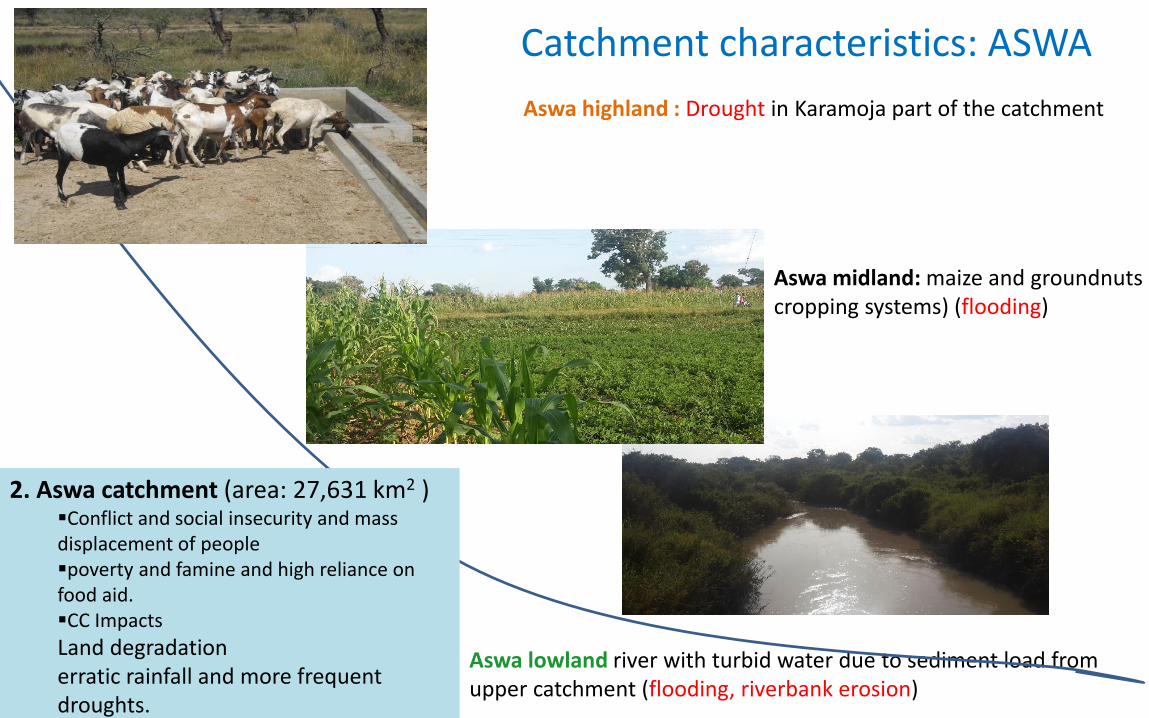
Aswa highland : Drought in Karamoja part of the catchment
Aswa midland: maize and groundnuts cropping systems) (flooding)
Aswa lowland river with turbid water due to sediment load from upper catchment (flooding, riverbank erosion)
Catchment characteristics: ASWA
2. Aswa catchment (area: 27,631 km2 )Conflict and social insecurity and mass displacement of peoplepoverty and famine and high reliance on food aid.CC Impacts
Land degradationerratic rainfall and more frequent droughts.
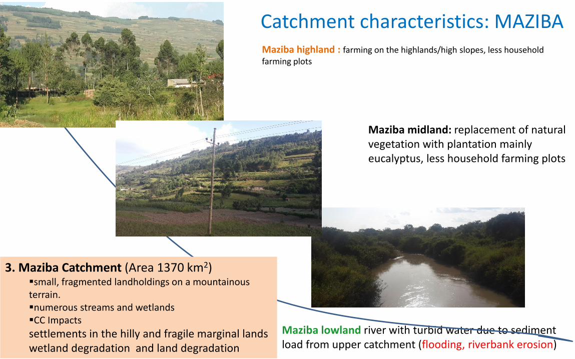
Maziba highland : farming on the highlands/high slopes, less household farming plots
Maziba midland: replacement of natural vegetation with plantation mainly eucalyptus, less household farming plots
Maziba lowland river with turbid water due to sediment load from upper catchment (flooding, riverbank erosion)
Catchment characteristics: MAZIBA
3. Maziba Catchment (Area 1370 km2) small, fragmented landholdings on a mountainous terrain. numerous streams and wetlandsCC Impacts
settlements in the hilly and fragile marginal lands wetland degradation and land degradation
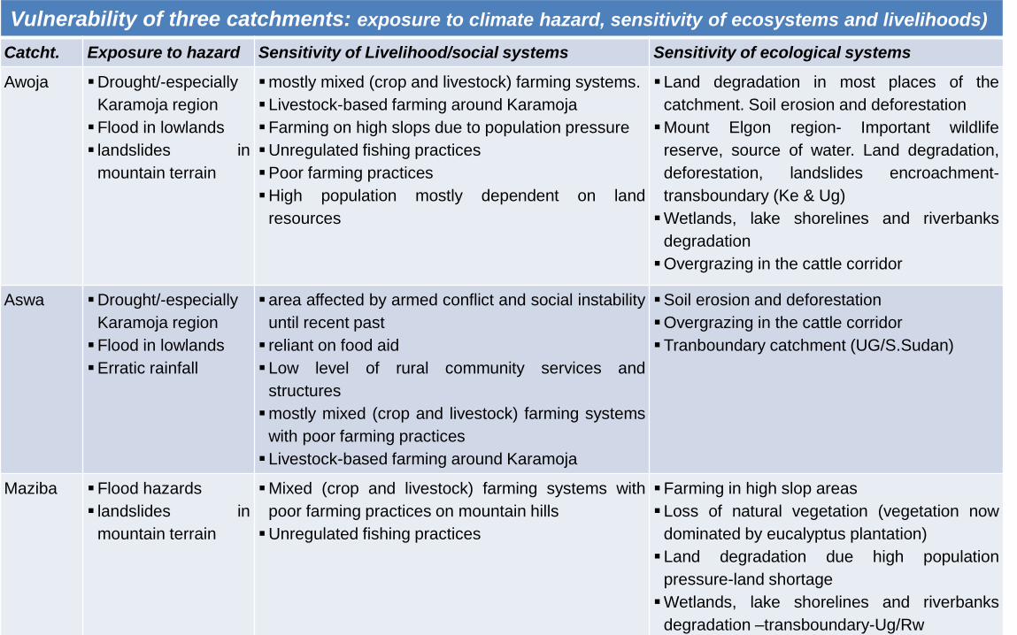
Vulnerability of three catchments: exposure to climate hazard, sensitivity of ecosystems and livelihoods)
Catcht. Exposure to hazard Sensitivity of Livelihood/social systems Sensitivity of ecological systems
Awoja Drought/-especially
Karamoja region
Flood in lowlands
landslides in
mountain terrain
mostly mixed (crop and livestock) farming systems.
Livestock-based farming around Karamoja
Farming on high slops due to population pressure
Unregulated fishing practices
Poor farming practices
High population mostly dependent on land
resources
Land degradation in most places of the
catchment. Soil erosion and deforestation
Mount Elgon region- Important wildlife
reserve, source of water. Land degradation,
deforestation, landslides encroachment-
transboundary (Ke & Ug)
Wetlands, lake shorelines and riverbanks
degradation
Overgrazing in the cattle corridor
Aswa Drought/-especially
Karamoja region
Flood in lowlands
Erratic rainfall
area affected by armed conflict and social instability
until recent past
reliant on food aid
Low level of rural community services and
structures
mostly mixed (crop and livestock) farming systems
with poor farming practices
Livestock-based farming around Karamoja
Soil erosion and deforestation
Overgrazing in the cattle corridor
Tranboundary catchment (UG/S.Sudan)
Maziba Flood hazards
landslides in
mountain terrain
Mixed (crop and livestock) farming systems with
poor farming practices on mountain hills
Unregulated fishing practices
Farming in high slop areas
Loss of natural vegetation (vegetation now
dominated by eucalyptus plantation)
Land degradation due high population
pressure-land shortage
Wetlands, lake shorelines and riverbanks
degradation –transboundary-Ug/Rw
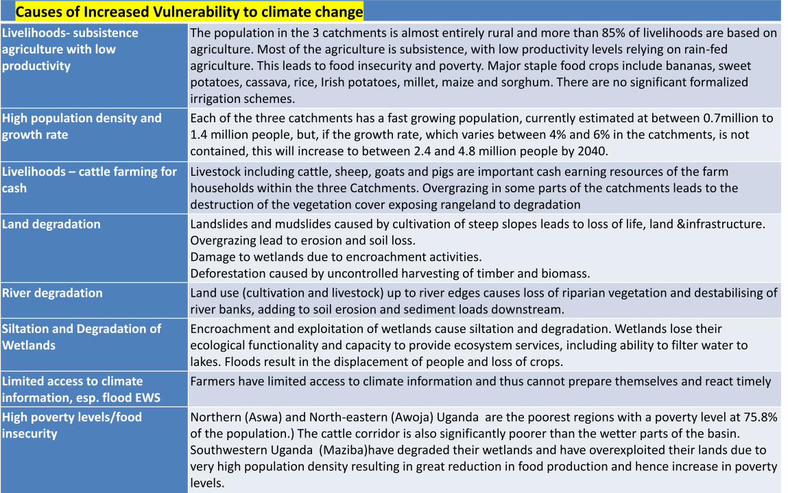
Causes of Increased Vulnerability to climate changeLivelihoods- subsistence agriculture with low productivity
The population in the 3 catchments is almost entirely rural and more than 85% of livelihoods are based on agriculture. Most of the agriculture is subsistence, with low productivity levels relying on rain-fed agriculture. This leads to food insecurity and poverty. Major staple food crops include bananas, sweet potatoes, cassava, rice, Irish potatoes, millet, maize and sorghum. There are no significant formalized irrigation schemes.
High population density and growth rate
Each of the three catchments has a fast growing population, currently estimated at between 0.7million to 1.4 million people, but, if the growth rate, which varies between 4% and 6% in the catchments, is not contained, this will increase to between 2.4 and 4.8 million people by 2040.
Livelihoods – cattle farming for cash
Livestock including cattle, sheep, goats and pigs are important cash earning resources of the farm households within the three Catchments. Overgrazing in some parts of the catchments leads to the destruction of the vegetation cover exposing rangeland to degradation
Land degradation Landslides and mudslides caused by cultivation of steep slopes leads to loss of life, land &infrastructure.Overgrazing lead to erosion and soil loss.Damage to wetlands due to encroachment activities. Deforestation caused by uncontrolled harvesting of timber and biomass.
River degradation Land use (cultivation and livestock) up to river edges causes loss of riparian vegetation and destabilising of river banks, adding to soil erosion and sediment loads downstream.
Siltation and Degradation of Wetlands
Encroachment and exploitation of wetlands cause siltation and degradation. Wetlands lose their ecological functionality and capacity to provide ecosystem services, including ability to filter water to lakes. Floods result in the displacement of people and loss of crops.
Limited access to climate information, esp. flood EWS
Farmers have limited access to climate information and thus cannot prepare themselves and react timely
High poverty levels/food insecurity
Northern (Aswa) and North-eastern (Awoja) Uganda are the poorest regions with a poverty level at 75.8% of the population.) The cattle corridor is also significantly poorer than the wetter parts of the basin. Southwestern Uganda (Maziba)have degraded their wetlands and have overexploited their lands due to very high population density resulting in great reduction in food production and hence increase in poverty levels.
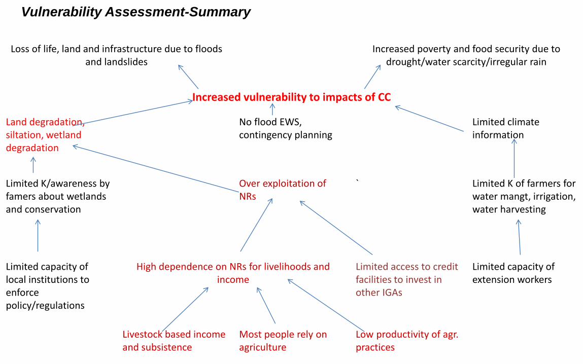
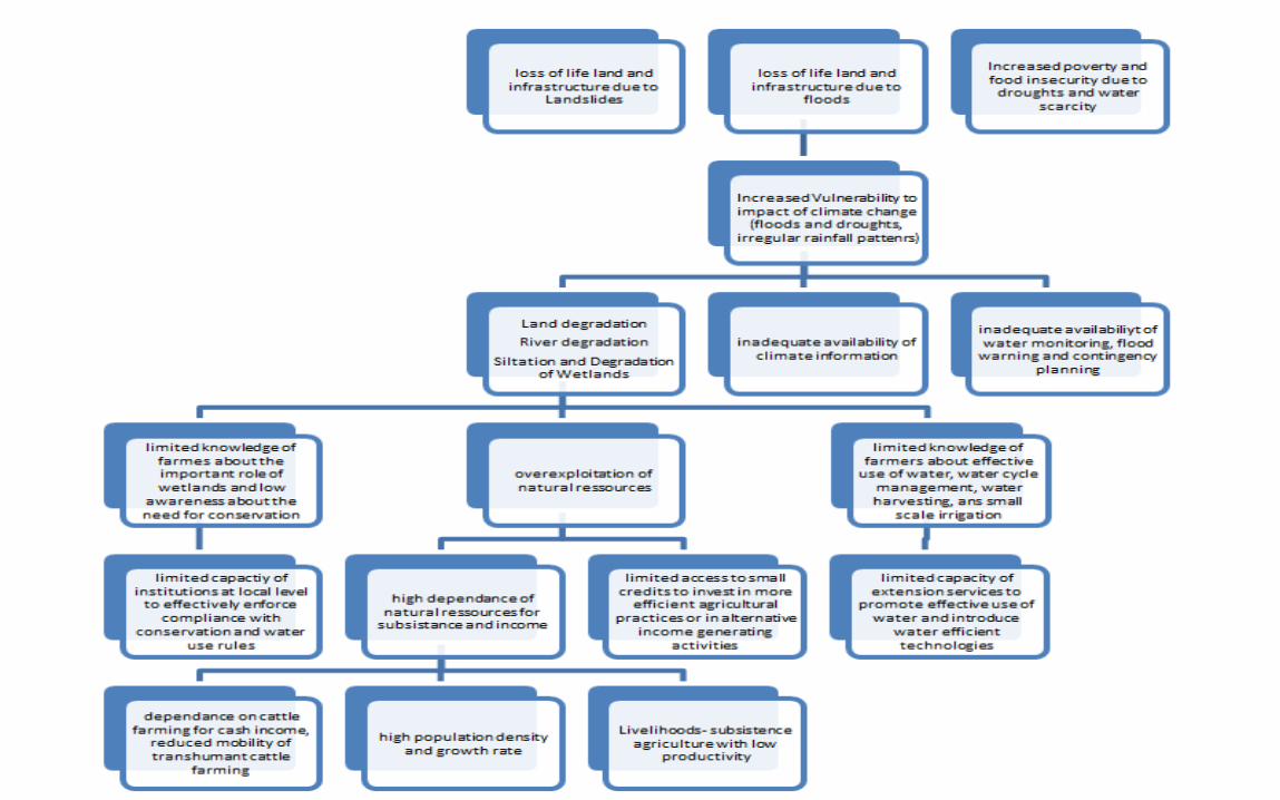
Loss of life, land and infrastructure due to floods and landslides
Increased poverty and food security due to drought/water scarcity/irregular rain
Increased vulnerability to impacts of CC
Land degradation, siltation, wetland degradation
No flood EWS, contingency planning
Limited climate information
Limited K/awareness by famers about wetlands and conservation
Over exploitation of NRs
` Limited K of farmers for water mangt, irrigation, water harvesting
Limited capacity of local institutions to enforce policy/regulations
High dependence on NRs for livelihoods and income
Limited access to credit facilities to invest in other IGAs
Limited capacity of extension workers
Livestock based income and subsistence
Most people rely on agriculture
Low productivity of agr. practices
Vulnerability Assessment-Summary
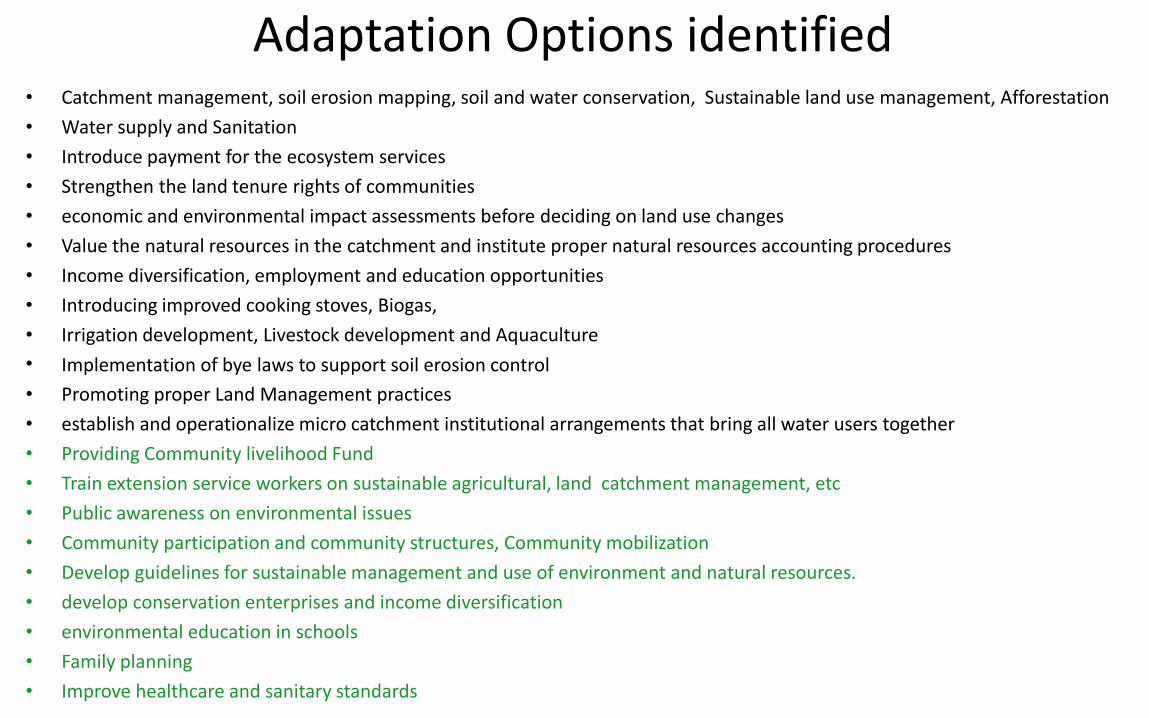
Adaptation Options identified• Catchment management, soil erosion mapping, soil and water conservation, Sustainable land use management, Afforestation
• Water supply and Sanitation
• Introduce payment for the ecosystem services
• Strengthen the land tenure rights of communities
• economic and environmental impact assessments before deciding on land use changes
• Value the natural resources in the catchment and institute proper natural resources accounting procedures
• Income diversification, employment and education opportunities
• Introducing improved cooking stoves, Biogas,
• Irrigation development, Livestock development and Aquaculture
• Implementation of bye laws to support soil erosion control
• Promoting proper Land Management practices
• establish and operationalize micro catchment institutional arrangements that bring all water users together
• Providing Community livelihood Fund
• Train extension service workers on sustainable agricultural, land catchment management, etc
• Public awareness on environmental issues
• Community participation and community structures, Community mobilization
• Develop guidelines for sustainable management and use of environment and natural resources.
• develop conservation enterprises and income diversification
• environmental education in schools
• Family planning
• Improve healthcare and sanitary standards
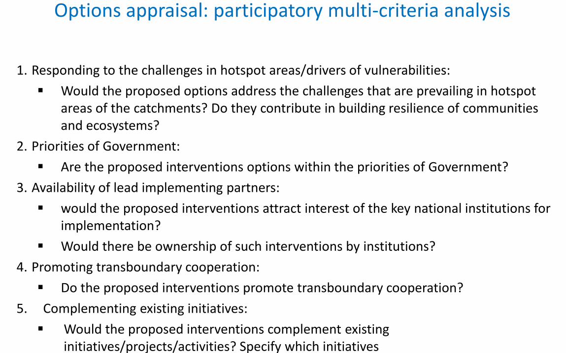
Options appraisal: participatory multi-criteria analysis
1. Responding to the challenges in hotspot areas/drivers of vulnerabilities:
Would the proposed options address the challenges that are prevailing in hotspot areas of the catchments? Do they contribute in building resilience of communities and ecosystems?
2. Priorities of Government:
Are the proposed interventions options within the priorities of Government?
3. Availability of lead implementing partners:
would the proposed interventions attract interest of the key national institutions for implementation?
Would there be ownership of such interventions by institutions?
4. Promoting transboundary cooperation:
Do the proposed interventions promote transboundary cooperation?
5. Complementing existing initiatives:
Would the proposed interventions complement existing initiatives/projects/activities? Specify which initiatives
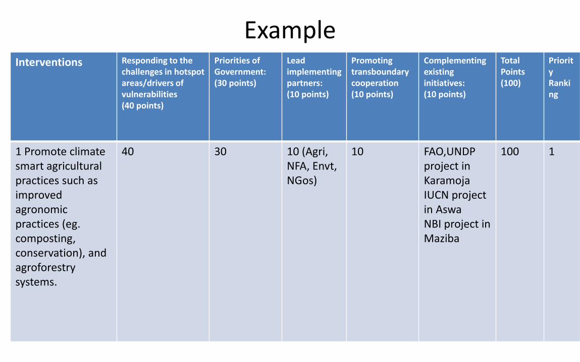
ExampleInterventions Responding to the
challenges in hotspot areas/drivers of vulnerabilities(40 points)
Priorities of Government:(30 points)
Lead implementing partners: (10 points)
Promoting transboundary cooperation(10 points)
Complementing existing initiatives: (10 points)
TotalPoints(100)
Priority Ranking
1 Promote climate smart agricultural practices such as improved agronomic practices (eg. composting, conservation), and agroforestry systems.
40 30 10 (Agri, NFA, Envt, NGos)
10 FAO,UNDPproject in KaramojaIUCN project in AswaNBI project in Maziba
100 1
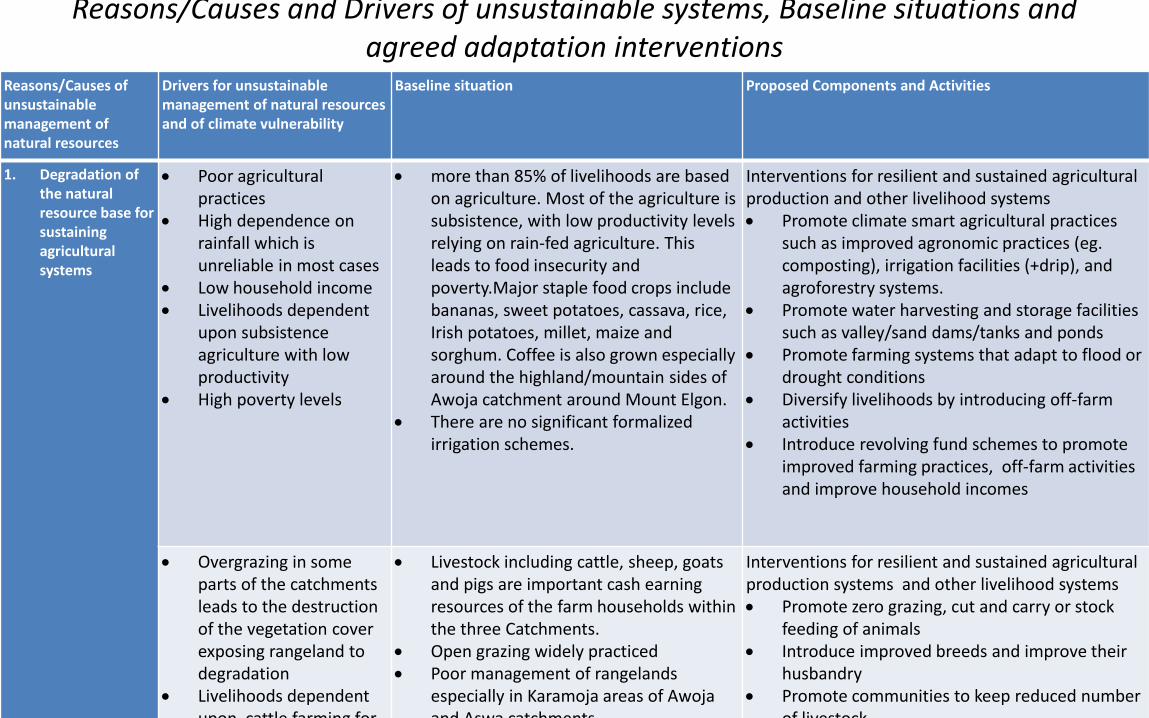
Reasons/Causes and Drivers of unsustainable systems, Baseline situations and agreed adaptation interventions
Reasons/Causes of unsustainable management of natural resources
Drivers for unsustainable management of natural resources and of climate vulnerability
Baseline situation Proposed Components and Activities
1. Degradation of the natural resource base for sustaining agricultural systems
Poor agricultural practices
High dependence on rainfall which is unreliable in most cases
Low household income Livelihoods dependent
upon subsistence agriculture with low productivity
High poverty levels
more than 85% of livelihoods are based on agriculture. Most of the agriculture is subsistence, with low productivity levels relying on rain-fed agriculture. This leads to food insecurity and poverty.Major staple food crops include bananas, sweet potatoes, cassava, rice, Irish potatoes, millet, maize and sorghum. Coffee is also grown especially around the highland/mountain sides of Awoja catchment around Mount Elgon.
There are no significant formalized irrigation schemes.
Interventions for resilient and sustained agricultural production and other livelihood systems Promote climate smart agricultural practices
such as improved agronomic practices (eg. composting), irrigation facilities (+drip), and agroforestry systems.
Promote water harvesting and storage facilities such as valley/sand dams/tanks and ponds
Promote farming systems that adapt to flood or drought conditions
Diversify livelihoods by introducing off-farm activities
Introduce revolving fund schemes to promote improved farming practices, off-farm activities and improve household incomes
Overgrazing in some parts of the catchments leads to the destruction of the vegetation cover exposing rangeland to degradation
Livelihoods dependent upon cattle farming for
Livestock including cattle, sheep, goats and pigs are important cash earning resources of the farm households within the three Catchments.
Open grazing widely practiced Poor management of rangelands
especially in Karamoja areas of Awojaand Aswa catchments
Interventions for resilient and sustained agricultural production systems and other livelihood systems Promote zero grazing, cut and carry or stock
feeding of animals Introduce improved breeds and improve their
husbandry Promote communities to keep reduced number
of livestock
Reasons/Causes and Drivers of unsustainable systems, Baseline situations and agreed adaptation interventions
Reasons/Causes of unsustainable management of natural resources
Drivers for unsustainable management of natural resources and of climate vulnerability
Baseline situation Proposed Components and Activities
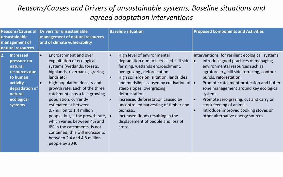
2. Increased pressure on natural resources due to human activity-degradation of natural ecological systems
Encroachment and over exploitation of ecological systems (wetlands, forests, highlands, riverbanks, grazing lands etc)
High population density and growth rate. Each of the three catchments has a fast growing population, currently estimated at between 0.7million to 1.4 million people, but, if the growth rate, which varies between 4% and 6% in the catchments, is not contained, this will increase to between 2.4 and 4.8 million people by 2040.
High level of environmental degradation due to increased hill side farming, wetlands encroachment, overgrazing , deforestation
High soil erosion, siltation, landslides and mudslides caused by cultivation of steep slopes, overgrazing, deforestation
Increased deforestation caused by uncontrolled harvesting of timber and biomass.
Increased floods resulting in the displacement of people and loss of crops.
Interventions for resilient ecological systems Introduce good practices of managing
environmental resources such as agroforestry, hill side terracing, contour bunds, reforestation,
Promote catchment protection and buffer zone management around key ecological systems
Promote zero grazing, cut and carry or stock feeding of animals
Introduce improved cooking stoves or other alternative energy sources
Reasons/Causes and Drivers of unsustainable systems, Baseline situations and agreed adaptation interventions
Reasons/Causes of unsustainable management of natural resources
Drivers for unsustainable management of natural resources and of climate vulnerability
Baseline situation Proposed Components and Activities
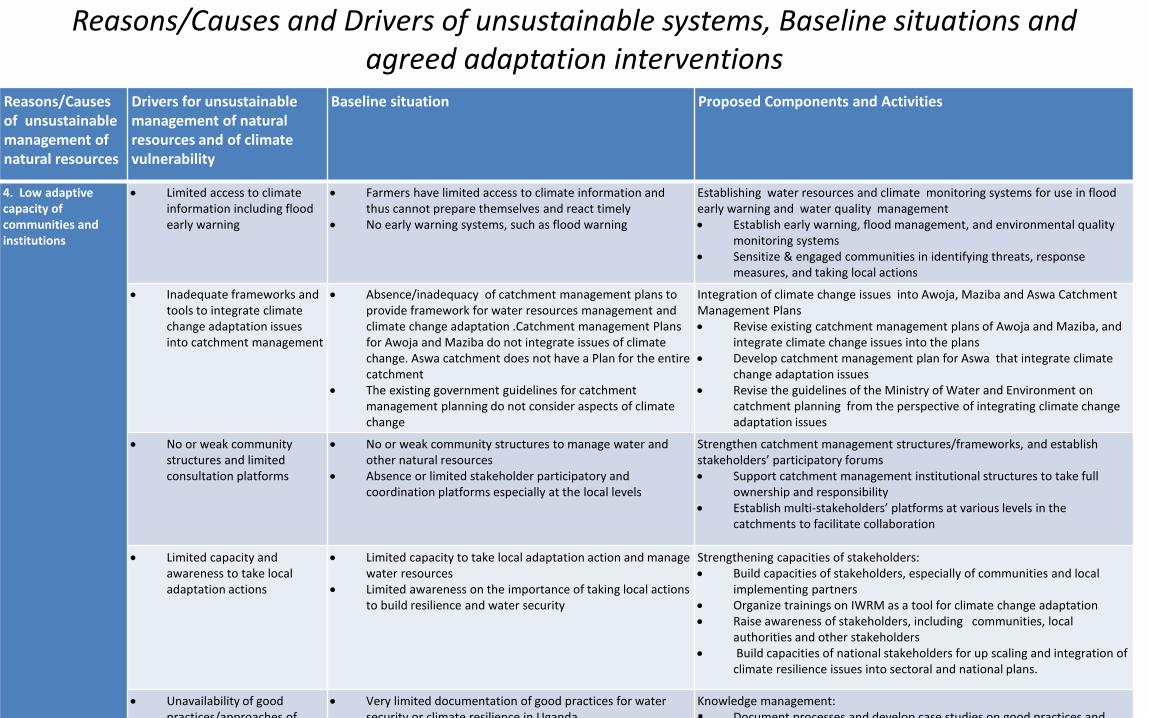
4. Low adaptive capacity of communities and institutions
Limited access to climate information including flood early warning
Farmers have limited access to climate information and thus cannot prepare themselves and react timely
No early warning systems, such as flood warning
Establishing water resources and climate monitoring systems for use in flood early warning and water quality management Establish early warning, flood management, and environmental quality
monitoring systems Sensitize & engaged communities in identifying threats, response
measures, and taking local actions
Inadequate frameworks and tools to integrate climate change adaptation issues into catchment management
Absence/inadequacy of catchment management plans to provide framework for water resources management and climate change adaptation .Catchment management Plans for Awoja and Maziba do not integrate issues of climate change. Aswa catchment does not have a Plan for the entire catchment
The existing government guidelines for catchment management planning do not consider aspects of climate change
Integration of climate change issues into Awoja, Maziba and Aswa Catchment Management Plans Revise existing catchment management plans of Awoja and Maziba, and
integrate climate change issues into the plans Develop catchment management plan for Aswa that integrate climate
change adaptation issues Revise the guidelines of the Ministry of Water and Environment on
catchment planning from the perspective of integrating climate change adaptation issues
No or weak community structures and limited consultation platforms
No or weak community structures to manage water and other natural resources
Absence or limited stakeholder participatory and coordination platforms especially at the local levels
Strengthen catchment management structures/frameworks, and establish stakeholders’ participatory forums Support catchment management institutional structures to take full
ownership and responsibility Establish multi-stakeholders’ platforms at various levels in the
catchments to facilitate collaboration
Limited capacity and awareness to take local adaptation actions
Limited capacity to take local adaptation action and manage water resources
Limited awareness on the importance of taking local actions to build resilience and water security
Strengthening capacities of stakeholders: Build capacities of stakeholders, especially of communities and local
implementing partners Organize trainings on IWRM as a tool for climate change adaptation Raise awareness of stakeholders, including communities, local
authorities and other stakeholders Build capacities of national stakeholders for up scaling and integration of
climate resilience issues into sectoral and national plans.
Unavailability of good practices/approaches of
Very limited documentation of good practices for water security or climate resilience in Uganda
Knowledge management: Document processes and develop case studies on good practices and
Institutions participated in the processN Institution/ Departments Mandates/
Main objectives of institutions Role/contribution in Project Preparation
1 Ministry of Finance Planning and Economic Development
Coordinating overall National Development planning and budgeting
Designated National Authority
Endorsed the Project Communicated on behalf of the Government of Uganda
2 Ministry of Water and Environment (MWE)
Policy and regulatory role for water and environmental issues
Executing Entity, together with GWP, technically coordinated the program development process
Made available key government documents3 National Environmental
Management Authority (NEMA) Regulatory authority for all environmental issues Provided guidance regarding the required social and environmental
impact assessments per Ugandan law Cleared the TOR and processes of conducting environmental and
social impact assessments
4 Uganda National Meteorological Authority (UNMA)
Meteorological services Contributed by reviewing the draft project proposal
5 Directorate of Environment Affairs, MWE
Policy and coordination of environmental activities
Contributed by reviewing the draft project proposal
6 Directorate of Water Resources Management, MWE
Policy implementation and coordination of water resources management activities
implementation of standards regarding waterquality and the issuance of permits
Lead Directorate with responsibility of executing the project on behalf of the MWE.
In collaboration with GWPEA, facilitated the process of project proposal development
7 Climate Change Department, MWE Policy and coordination of climate change issues UNFCC Focal Point
Contributed by reviewing the draft project proposal Provided the technical endorsement of the project content
8 Policy and Planning Department, MWE
Coordinating policy and planning of the Ministry Contributed by reviewing the draft project proposal, especially in making sure that the proposed project is in line with government priorities and strategies
9 International Union for Conservation of Nature (IUCN)
Nature conservation
Ecosystem based adaptation
Wetlands management
Experience sharing on revolving fund
Linking with its project in Aswa catchment
Contributed by reviewing the draft project proposal
10 ECOTRUST Environmental conservation Contributed by reviewing the draft project proposal
11 Environment Alert/ENRsNET (Environment and Natural Resources Network of CSOs)*
Environmental conservation
Networking and capacity building
Advocacy and lobbying
Contributed by reviewing the draft project proposal
Providing information on NGOs that are active in the project sites
12 UNDP-Country Office-Uganda Development partner Contributed by reviewing the draft project proposal
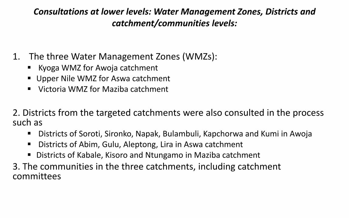
Consultations at lower levels: Water Management Zones, Districts and catchment/communities levels:
1. The three Water Management Zones (WMZs): Kyoga WMZ for Awoja catchment Upper Nile WMZ for Aswa catchment Victoria WMZ for Maziba catchment
2. Districts from the targeted catchments were also consulted in the process such as
Districts of Soroti, Sironko, Napak, Bulambuli, Kapchorwa and Kumi in Awoja Districts of Abim, Gulu, Aleptong, Lira in Aswa catchment Districts of Kabale, Kisoro and Ntungamo in Maziba catchment
3. The communities in the three catchments, including catchment committees
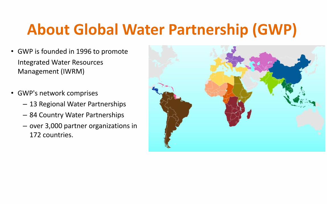
About Global Water Partnership (GWP)• GWP is founded in 1996 to promote
Integrated Water Resources Management (IWRM)
• GWP's network comprises
– 13 Regional Water Partnerships
– 84 Country Water Partnerships
– over 3,000 partner organizations in 172 countries.
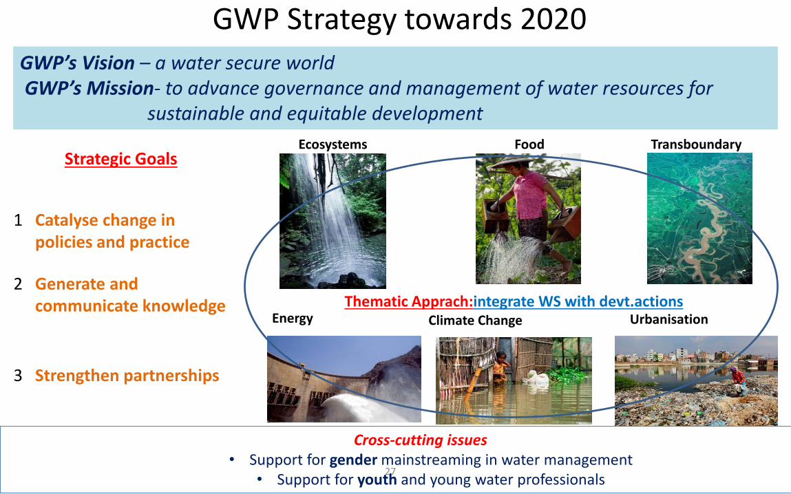
Cross-cutting issues • Support for gender mainstreaming in water management
• Support for youth and young water professionals
GWP Strategy towards 2020
27
FoodEcosystems Transboundary
Energy Climate Change Urbanisation
Strategic Goals
1 Catalyse change in policies and practice
2 Generate and communicate knowledge
3 Strengthen partnerships
GWP’s Vision – a water secure worldGWP’s Mission- to advance governance and management of water resources for
sustainable and equitable development
Thematic Apprach:integrate WS with devt.actions
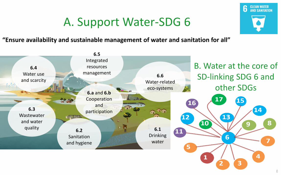
A. Support Water-SDG 6“Ensure availability and sustainable management of water and sanitation for all”
6.1Drinking
water
6.2Sanitation
and hygiene
6.3Wastewaterand water
quality
6.4Water use
and scarcity
6.5Integratedresources
management6.6
Water-related eco-systems
6.a and 6.bCooperation
and participation
B. Water at the core of SD-linking SDG 6 and
other SDGs