Embed Size (px)
Citation preview

1
WATER ON AND UNDER
GROUND
Objectives
• Define and describe the hydrologic cycle.
• Identify the basic characteristics of streams.
• Define drainage basin.
• Describe how floods occur and what factors may
make them worse.
• Define recurrence interval and show how it is used to
predict floods.
• Define water table.
• Identify two types of aquifers.
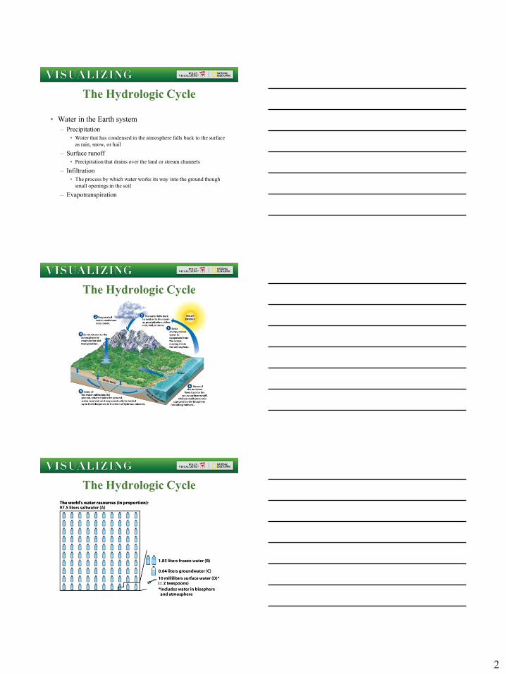
The Hydrologic Cycle
• Hydrology
– The scientific study of water
• Evaporation
– Water changes from a liquid into water
• Transpiration
– Water taken up by plants passes into the atmosphere
• Condensation
– Water changes from a vapor into a liquid or a solid
2
The Hydrologic Cycle
• Water in the Earth system
– Precipitation
• Water that has condensed in the atmosphere falls back to the surface
as rain, snow, or hail
– Surface runoff
• Precipitation that drains over the land or stream channels
– Infiltration
• The process by which water works its way into the ground though
small openings in the soil
– Evapotranspiration
The Hydrologic Cycle
The Hydrologic Cycle

3
The Hydrologic Cycle
How Water Affects Land
• Streams and stream flow
– Stream• A body of water that flows
downslope along a clearly defined natural passageway
How Water Affects Land
• Streams and stream flow
– Channel• The clearly defined
passageway through which a stream flows
– Straight
– Meandering
– Braided

4
Qu’Appelle Valley, Manitoba
Meandering Stream
Braided stream
How Water Affects Land
• Streams and stream flows
– Gradient
• The steepness of a stream
channel
– Discharge
• The mount of water passing by
a point on a channel’s bank
during a unit of time
– Load
• The suspended and dissolved
sediment carried by a stream

5
Discharge is the amount of water that flows through a channel. Discharge is
calculated by first finding the cross-sectional area of a stream and then
multiplying this times the velocity. The result will always be in a measure of
volume per unit time. Rather than trying to measure streams everywhere all the
time, stream gages (measure points) are used to estimate flow.
Where Does Sediment Come From?
Stream sediment is
called load. One way
streams procure
sediment is by erosion
itself. Particles loosened
by weathering are
picked up in surface
runoff and transported
to the stream channel.

6
Mass movement
events may move
loose material
downslope into the
stream channel, the
second way streams
procure sediment.
The third way
streams procure
sediment: the
stream itself may
also erode the
banks of its
channel and that
sediment too
becomes part of
the stream’s load.
Here we can
visualize the various
motions of bedload
particles and see
how small eddy
currents keep
suspended load
entrained.
Sediment Load

7
• http://media.pearsoncmg.com/bc/bc_0media_geo/activ
e_art/hdew_2e.html?OxbowLake
Floodplains
Meander Abandonment
Why a sinuous stream meanders

8
How water Affects Land• Stream deposits
– Alluvium
• Stream sediment
• Recently deposited
(geologically speaking)
– Floodplain
– Natural Levee
– Alluvial fan (right)
– Delta
Suspended-load deposits build up floodplains.
Delta
• Stream deposit
– Delta: deposition of stream
sediment in a standing
body of water like a lake
sea, or ocean.

9
•Erosion of the
Mississippi Delta
Building of artificial levees,
dams, etc. starve a delta of
sediment. Erosion by waves then
begins to erode the delta.
How Water Affects Land
• Drainage basin
– The total area from which
water flows into a stream
• Divide
– A topographic high that
separates adjacent drainage
basins
• Lakes
– Standing bodies of water that
have open surfaces, in direct
contact with the atmosphere
The Drainage Basin: all the area that supplies
water to a stream and its tributaries
10
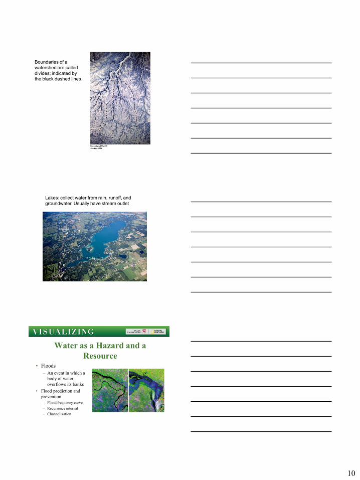
Boundaries of a
watershed are called
divides; indicated by
the black dashed lines.
Lakes: collect water from rain, runoff, and
groundwater. Usually have stream outlet
Water as a Hazard and a
Resource• Floods
– An event in which a
body of water
overflows its banks
• Flood prediction and
prevention
– Flood frequency curve
– Recurrence interval
– Channelization

11
Floods (Flows greater than bankfull capacity)
Due to high intensity rainfall, usually seasonal.
Intense rain cannot be absorbed quickly enough, so it runs off into streams.
Flash floods associated with canyons are generally the deepest and often most damaging (below right).
These events are rapid (flash) and difficult to predict.
Flash floods
Water as a Hazard and a
Resource
• Hydrographs of stream discharge

12
Water as a Hazard and a
Resource
Water as a Hazard and a Resource
• Flood Frequency Curve
Water as a Hazard and a
Resource• Surface water resources
– Reliable water supply critical to human survival and health, agriculture
and other economic activities
– Nearly 250 million people are designated as water-scarce

13
Freshwater Underground
• Ground water
– Subsurface water
contained in pore
spaces in regolith
and bedrock
• Water table
– The top surface of
the saturated zone
Freshwater Underground
• How groundwater moves
– Porosity
• The percentage of the total volume of a
body of rock or regolith that consists of
open spaces (pores)
– Permeability
• Measure of how easily a solid allows
fluids to pass through it
30% 15%

14
Freshwater Underground
• How groundwater
moves (continued)
– Percolation
• Groundwater seeps
downward
• Flows under the
influence of gravity
– Recharge
• Replenishment of
groundwater
Freshwater Underground
• How groundwater
moves (continued)
– Discharge
• Subsurface water
leaves the saturated
zone
• Becomes surface water
– Spring
• Occurs where the water
table intersects the land
surface

15
Freshwater Underground
• Where groundwater is
stored
– Aquifer
• A body of rock or
regolith that is water
saturated, porous, and
permeable
– Aquiclude
• A layer of impermeable
rock
– Artesian well
Wells in confined aquifers

16
Freshwater Underground
• When groundwater
dissolves rock
– Karst topography
– Sinkholes
– Cave
• Underground open space
• A cavern is a system of
connected caves
Major karst landforms
• Dolines (sinkholes)
Collapse dolines
Colorado Plateau

17
Collapse dolines
Edwards Limestone, Texas: recharge area for Edwards
Aquifer
Solution or subsidence doline
Mitchell Plain, Indiana
Caves and Speleothems
Stalactite
Stalagmite
Column